Article

Propagation Characteristics of Hydrological Drought Based on Variable and Fixed Threshold Methods in Snowmelt and Rainfall Driven Catchments

1
State Key Laboratory of Hydrology-Water Resources and Hydraulic Engineering, Nanjing Hydraulic Research Institute, Nanjing 210000, China
2
Key Laboratory of Hydrometeorological Disaster Mechanism and Warning of Ministry of Water Resources, Collaborative Innovation Center on Forecast and Evaluation of Meteorological Disasters, Nanjing University of Information Science and Technology, Nanjing 210044, China
3
Inland Water Unit, Environmental Monitoring and Reporting Branch, Ontario Ministry of Environment, Conservation and Parks, Dorset, ON P0A 1E0, Canada
*
Authors to whom correspondence should be addressed.
Water 2022, 14(20), 3219; https://doi.org/10.3390/w14203219
Submission received: 1 September 2022 / Revised: 30 September 2022 / Accepted: 10 October 2022 / Published: 13 October 2022
(This article belongs to the Special Issue Challenges of Hydrological Drought Monitoring and Prediction)

Abstract

:
Based on long-term (>30 years) monthly streamflow data from two catchments with different hydrological features, i.e., snowmelt-driven in Harp Lake, south-central, Canada and rainfall-driven in Dongjiang river, south China, the differences in the hydrological drought (HD) propagation characteristics identified by fixed (FDT) and variable drought thresholds (VDT) were explored. The results showed that (i) despite both FDT and VDT methods being able to describe HD propagation patterns well (i.e., slow intensification but quick recovery), the onset time, peak intensity time, and termination time of HD within a year were significantly different between the two methods, due to the different drought conceptual backgrounds of the methods. (ii) The HD months identified by VDT were close to evenly distributed in each month of the year, while the HD months identified by FDT were mainly concentrated in the dry season. (iii) The onset, peak intensity, and termination time of HD identified by FDT were in good agreement with the dryness/wetness attributes of the two study basins and can be recommended in the study case. (iv) More methods for monitoring and predicting HD, and for revealing the driving mechanisms for HD propagation, are needed.

1. Introduction

Droughts develop slowly, and persistent droughts cause serious pressure on water resources and ecosystems [1,2,3]. Typically, droughts can be broadly classified into meteorological, agricultural, hydrological, and socio-economic droughts [3]; these four drought types refer to deficits of precipitation, soil moisture, runoff or river discharge, and social water supply, respectively. Hydrological droughts (HD), characterized by surface runoff or streamflow shortages, are caused by continuation of meteorological drought [4]. HD has a serious impact on the water quantity and water quality [5,6], causing water shortages, worsening water pollution, and affecting industrial and agricultural production [1,7]. Thus, effective monitoring and prediction of HD is beneficial for managing water resources, especially during droughts.
Commonly, drought propagation refers to the period or process from meteorological drought to other types of droughts (e.g., agricultural and hydrological) [8,9]. Some kind of threshold is applied to identify a drought and its propagation. The issues concerning the drought propagation threshold and propagation processes have been explored previously, providing many interesting results [10,11,12]. In general, drought propagation can be described as follows: following the HD onset, the lifecycle of a HD includes an intensification stage and a recovery stage [13,14]. The intensification stage is the period from the HD onset to the time when the peak intensity (maximum water shortage during HD) is realized, while the recovery stage refers to the period from the peak intensity to the complete termination of the drought. In recent years, research on the HD propagation processes, including the formation threshold (e.g., formation from meteorological drought to HD) [10,11,12], intensification and recovery patterns [13,14], the water required for recovery [3], and the impacts of climate change and human regulation activities on these processes [15,16,17,18] have received widespread attention. Monitoring or evaluation methods (e.g., drought index) for HD based on in situ observation and/or remote sensing data have also been developed [19,20,21].
Due to the complexity of the drivers and hydrologic responses to hydrological drought, previous studies have recommended multiple methods and multiple drought thresholds for identifying HD, because no single method or threshold is commonly applicable to all water users or managers [22,23]. Commonly, either a variable drought threshold or a fixed drought threshold is used to identify HD events and then analyze the propagation characteristics [23]. The variable drought threshold (VDT) method usually defaults the occurrence frequency of drought in a certain period (e.g., a month) of a year to be the same, and thus, multiple and variable thresholds are required for extracting HD events for different months. The threshold for identifying a HD for a month or season that is usually wet is quite different the threshold for a month or season which is usually dry. A fixed drought threshold (FDT) considers the entire time series of streamflow as a whole for a year or multiple years, and adopts only one threshold with special meaning, such as the ecological security flow, to identify a HD. The VDT and FDT have different concepts and principles, and thus, may reveal different results for HD events and their propagation processes. A recent study from Hammond et al. (2022) [24] found that, despite the spatial patterns of HD in the U.S. being consistent between VDT and FDT, the average HD duration identified from FDT was longer than that of VDT. Although previous studies have provided valuable information for monitoring and predicting HD under changing environments, using different methods separately [15,25], studies considering both VDT and FDT for extracting HD characteristics from a propagation perspective (i.e., timing of onset, peak intensity, and termination), and revealing the differences caused by the two threshold methods in basins with different hydrological features, are lacking, and this necessitates more in-depth research work.
Therefore, our study aimed to understand the differences between VDT and FDT for identifying the HD propagation characteristics in two selected catchments with different hydrological features (i.e., snowmelt- and rainfall-driven basins). We focused on three main tasks:
(i)
Reveal the difference in the HD distribution pattern within a year;
(ii)
Demonstrate the difference in the propagation characteristics of HD events;
(iii)
Determine/explain the possible reasons for these differences.
The results of this study may provide a reference for selecting reasonable HD assessment methods for a certain catchment, so as to further enrich drought theories.

2. Methods

2.1. Fixed and Variable Drought Threshold

A Q20 value (the 20% discharge on the cumulative frequency curve of historical streamflow from low to high) was commonly used to identify HD events in previous studies [15,23,24,25]. If a streamflow (Q) under a certain timescale (usually a few months) is below the Q20 threshold, i.e., the monthly streamflow in a river minus the Q20 threshold is negative (QQ20), it is regarded as a HD. The duration (D), severity (S), and intensity (I) are three basic characteristics of HD [2]. D is defined as the time span from the onset to the termination of the HD (i.e., the period from t1 to t2 in Figure 1), and the S is the absolute value for the sum of a negative drought index (QQ20) during the D. Similarly to reference [26], we created an HD index time series Qx(t) (i.e., QQ20) that specifies for each monthly time step ‘t’ if the streamflow variable Q(t) is at or below the threshold Q20 (Q20), and thus a streamflow anomaly below the threshold is identified, as defined in (Equation (1)):
Q x ( t ) = Q Q 20
One month or a few continuous months whose Qx(t) ≤ 0 indicate a HD event. Then, the accumulated months from the onset to termination of a certain HD is regarded as D. Thus, the severity S (Equation (2)) and intensity I (Equation (3)) for the HD event are:
S = t o n s e t t t e r m i n a t i o n [ Q x ( t ) 0 ]
I = S D
The units of D, S, and I are month, m3/s, and m3/s, because the same timescale for the streamflow (e.g., monthly streamflow (unit: m3/s)) was used. When a separate Q20 for each month within a year (thus twelve thresholds for a year) are determined to extract the HD events, this is called the variable drought threshold (VDT) method. If there is just one Q20 threshold for all months to extract HD events, this is the fixed drought threshold (FDT) method.

2.2. Identification of Hydrological Propagation Characteristics

According to the definition of previous studies [13,14], the duration D can be further divided into a drought intensification duration (DID) and drought recovery duration (DRD), based on the location of the time point of peak intensity (PI) (i.e., the t2 in Figure 1). The DID period is regarded as from the drought onset (i.e., t1 in Figure 1) to its PI (i.e., t2 in Figure 1), and the DRD is defined as from the PI time point (i.e., t2 in Figure 1) to the drought termination (i.e., t3 in Figure 1). In this study, the time points of onset (t1), PI (t2), and termination (t3) were extracted for analyzing the HD propagation characteristics of drought events. We chose the threshold of 0 as a preliminary criterion for the onset and termination time of a drought based on HD time series (i.e., Sx(t)). The reason for this was that when the Qx(t) is lower (or larger) than 0, the streamflow is in a shortage (or surplus) condition [3]. It is noted that the termination time is the first month when the Qx(t) > 0 after the drought end. Since the monthly streamflow was used to extract DID and DRD for a HD event in this study, the HD events longer than 3 months D were extracted for analyzing their propagation characteristics [13]. The linear trend and box-plot methods were also used to analyze the variation of the variables of interest in this study.

3. Study Case and Dataset

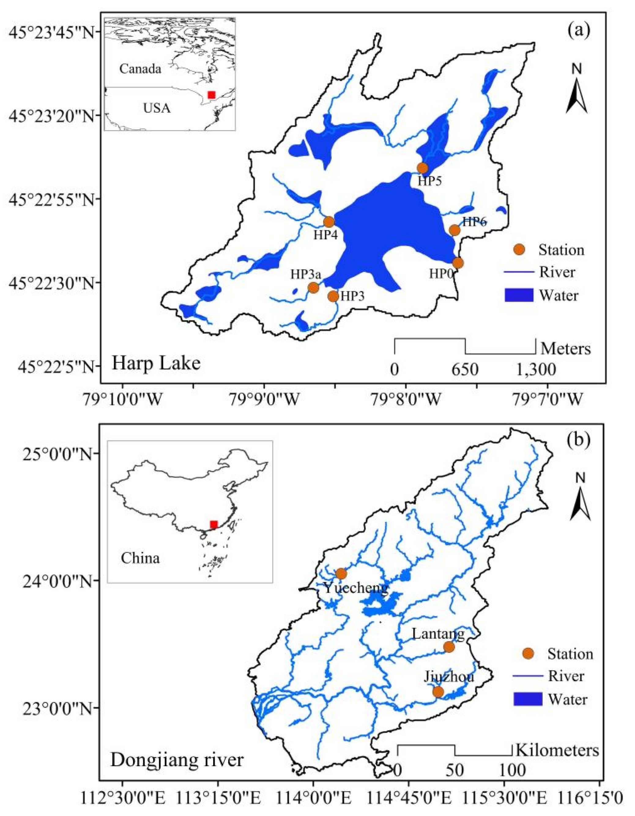
This study focuses on two catchments: the Harp Lake catchment, which is located in south-central Ontario, Canada, and has an area of 5.42 km2 (Figure 2a); and Dongjiang River catchment, which is located in south China and has an area of 31,840 km2. The Harp Lake catchment is a typical snowmelt-driven basin. Approximately one third of annual rainfall falls as snow in winter, with the majority of rain falling in autumn (accounting for 30% of the annual precipitation based on monthly records), and most runoff is from the spring snowmelt in the Harp Lake catchment. HP0, HP3, HP3a, HP4, HP5, and HP6 are the six drainage basins in the catchment, facilitated by long-term environmental monitoring of water quantity (Table 1). HP0 is the final controlling point of the catchment. Monthly streamflow was collected for these sites. The data were collected by the Inland Waters Unit, Environmental Monitoring and Reporting Branch, Ontario Ministry of Environment, Conservation and Parks, Canada.
Regarding the Dongjiang River catchment (Figure 2b), it is a typical rainfall-driven basin, where approximately 80% of the annual precipitation occurs in the warm season, from April to September [27,28]. Yuecheng, Lantang, and Jiuzhou are three branches of the Dongjiang River basin and have long-term streamflow records [27,28,29]. The monthly streamflows for Yuecheng, Lantang, and Jiuzhou were obtained from the water conservancy and electric power bureau of Guangdong Province, China (Table 1). All datasets have undergone strict quality control and have been used in previous studies [27,28,29,30,31,32,33,34].

4. Results and Discussion

4.1. Distribution Patterns of Streamflow within a Year

Figure 3 shows the variation of monthly streamflow within a year in the Harp Lake Figure 3a–f and Dongjiang River Figure 3g–i catchment. There are similar variation patterns of the monthly streamflow for the six stations of Harp Lake catchment and three stations of Dongjiang River catchment. For the two catchments, the monthly streamflow varies greatly between different months of the year.
For the Harp Lake catchment, the average of streamflow (i.e., the little square symbol in the box-plots) in April is the largest. For the Dongjiang River catchment, the average streamflow in August is the largest. Extreme streamflows (red circles), including extreme high (over the 95% quantile) and low streamflows (lower than the 5% quantile), occur in most months in the two selected catchments. The occurrence of samples for the extreme low streamflows were less frequent than extreme high streamflows (i.e., the boxplots of the tentacle extension for the extreme high flow are longer than that of extreme low flow). In other words, the frequency of extreme drought in the Harp Lake and Dongjiang River catchment was lower than the flooding frequency.
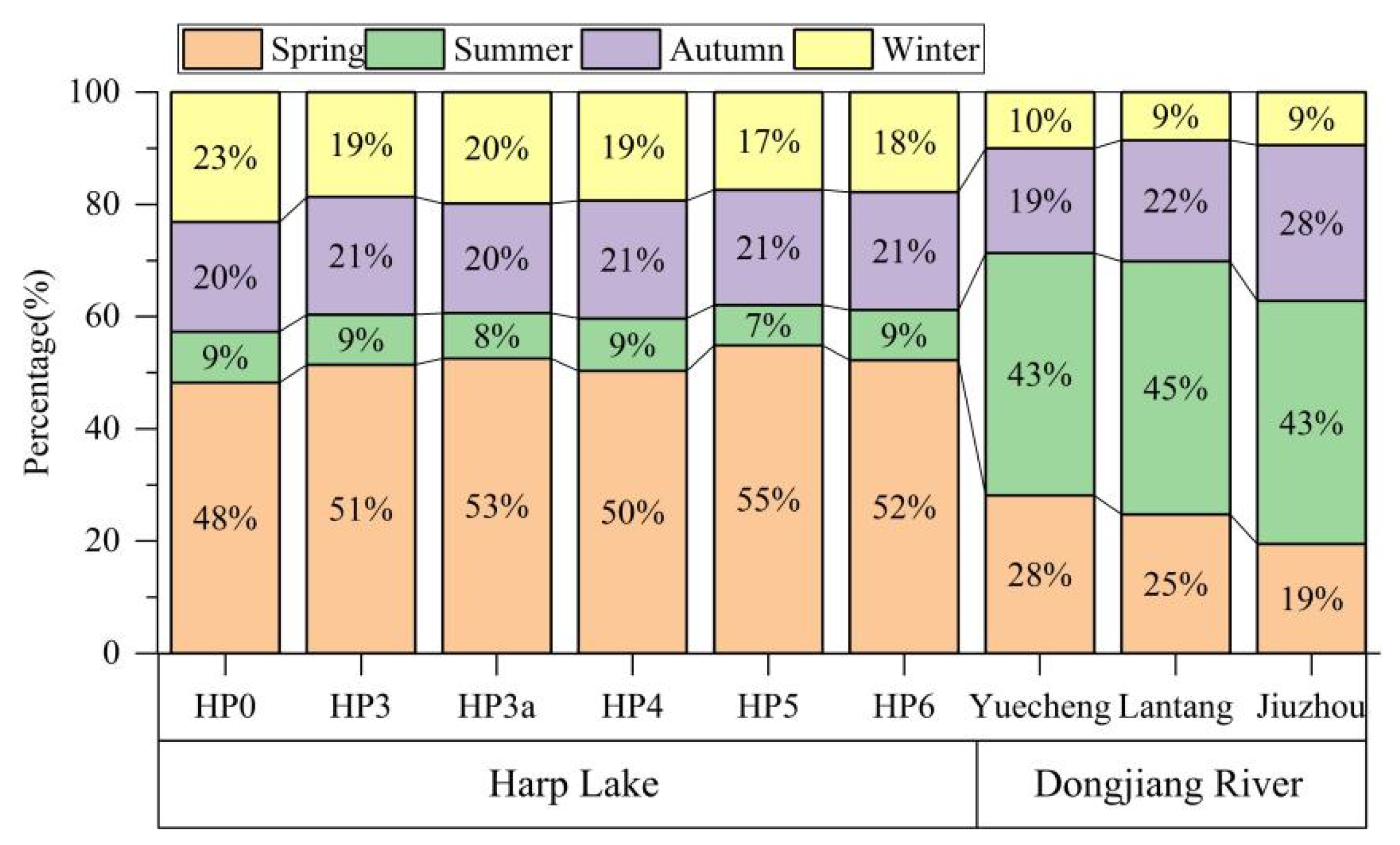
For the seasonal streamflow, the ratio of seasonal mean streamflow to the total annual streamflow was the largest in spring for the Harp Lake catchment and in summer for the Dongjiang River catchment (Figure 4). For the six stations of the Harp Lake catchment, the ratios of spring streamflow to the total annual flow were 48%, 51%, 53%, 50%, 55%, and 52%, at HP0, HP3, HP3a, HP4, HP5, and HP6, respectively. For the three stations of the Dongjiang River catchment, the ratios of summer streamflow to the total annual flow were 43%, 45%, and 43%, at Yuecheng, Lantang, and Jiuzhou, respectively.

4.2. Distribution Patterns of Hydrological Droughts within a Year

Since the HP0 site is the outlet control site for the Harp Lake catchment, and as Lantang has the longest streamflow records among the three stations of the Dongjiang River catchment, the HD at the HP0 site and Lantang station were identified and illustrated based on the methods developed in Section 2. The HD identified using the FDT and VDT methods were obviously different, both in the Harp Lake Figure 5a,b or Dongjiang River Figure 5c,d catchments.
For the HP0 station of the Harp Lake catchment, there were 35 and 50 HD events identified based on the FDT and VDT methods, in which 22 and 8 HD events have durations longer than 3 months, respectively. The most HD months extracted using the FDT method mainly occurred from June to October (dry season), especially from July to September (Figure 5a). However, the distribution of HD months identified using the VDT method occurred over all months (Figure 5b). The HD event with the longest duration occurred in 1998, with 7 months (from May to November in 1998) and a 0.12 m3/s deficit based on the FDT method, and with 8 months (from May to December in 1998) and a 0.13 m3/s deficit based on the VDT method. The year 1998 had one of the major droughts recorded in Canada [35]. The average D and S for the HD events with longer than 3 months identified by FDT (VDT) were 3.91 (4.67) months and 0.0634 (0.0421) m3/s, respectively (Table 1). The average of DID was shorter than that of DRD for both FDT (2.64 vs. 1.27 months) and VDT (3.33 vs. 1.33 months) (Table 2).
For the Lantang station of the Dongjiang River catchment, there were 52 and 52 HD events identified based on the FDT and VDT methods, in which 19 and 15 HD events had a duration longer than 3 months, respectively. The majority of HD months identified using the FDT method occurred from October to March of the next year (dry season). However, the HD months extracted with the VDT method occurred over all months. The HD event with the longest duration occurred in 1963–1964, with 15 months (from January 1963 to March 1964) and a 44.59 m3/s deficit based on the FDT method; and 14 months (from February 1963 to March 1964) and a 84.38 m3/s deficit based on the VDT method. The major drought event in 1963–1964 was also identified by previous studies using standardized drought methods in south China [3,10]. The average D and S for the HD events longer than 3 months identified by FDT (VDT) were 5.05 (5.47) months and 10.62 (23.58) m3/s, respectively (Table 1). The average of DID was shorter than that of DRD for both FDT (2.64 vs. 1.27 months) and VDT (3.33 vs. 1.33 months) (Table 2).
Generally, most HD months extracted using the FDT method occurred in the dry season for the two study catchments, but the HD months identified using the VDT method occurred over all months, because the Q20 threshold for each month was used, and there was about a 20% probability HD for every month. Moreover, the HD duration and severity identified using the FDT method was shorter and smaller than with VDT. By comparing Figure 5a,b and Figure 5c,d, the HD severity in the dry season identified with the FDT method was more severe than for the VDT; however, the HD severity in the wet season extracted using the FDT method was lesser than with VDT, because almost no HD was identified by FDT during the wet season.

4.3. Hydrological Drought Propagation Characteristics

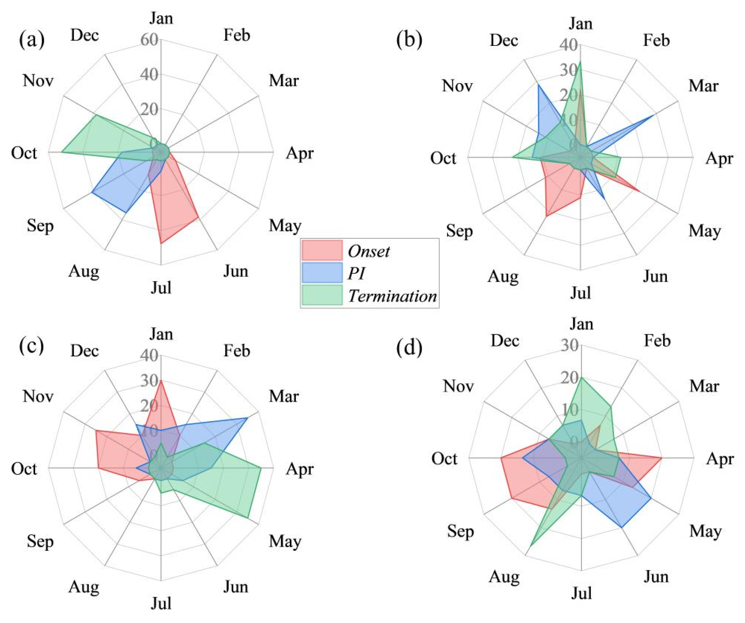
The onset, PI, and termination time of HD events identified using the FDT method mainly occurred in June to November in the HP0 station of Harp Lake catchment (Figure 6a). Most of onset time of HD events occurred in June and July, the PI time mostly occurred from August to October, and the termination time was mostly focused in October and November. However, the onset, PI, and termination time of HD events extracted using the VDT method were distributed or scattered in all months (Figure 6b) at the HP0 station of the Harp Lake catchment. Relatively speaking, the most onset time of HD events identified using the VDT method occurred in January, April, and October, while the PI time of HD events mostly occurred in March and December, and the termination time of HD events mostly occurred in January and October. For the Lantang station of the Dongjiang River catchment, the times for the onset, PI, and termination of HD events identified using the FDT method mainly occurred from October to May (mostly occurring in the dry season) Figure 6c. In addition, these key time points of HD events identified using the VDT method were distributed or scattered in all months within the year at the Lantang station of the Dongjiang River catchment Figure 6d. Overall, there were very different results for the onset, PI, and termination time of HD events extracted using the FDT and VDT methods.

4.4. Variation of Hydrological Drought Characteristics

There is a regular and significant positive relationship between the duration and severity of HD both with the FDT (p = 0.00) and VDT (p = 0.00) methods for the HP0 station of Harp Lake (Figure 7a,b) and the Lantang station of Dongjiang River (Figure 7e,f) catchments; when the duration increases, the severity also increases. Conversely, the relationship between duration and severity under the FDT method was better than that under the VDT method (i.e., R2 = 0.89 vs. R2 = 0.43 at the HP0 station of Harp Lake catchment, and R2 = 0.78 vs. R2 = 0.68 in the Lantang station of the Dongjiang River catchment). An insignificantly decreasing trend for the HD intensity is seen for the FDT (slope= −0.1335, R2 = 0.1, p = 0.06) and VDT (slope= −0.0351, R2 = 0.00, p = 0.81) results identified in past few decades of the Harp Lake catchment (Figure 7c,d). In addition, for the Dongjiang catchment, a decreasing trend for HD intensity was identified with both the FDT and VDT methods, with an insignificant (slope= −0.0137, R2 = 0.05, p = 0.13) decreasing trend for HD intensity extracted using the FDT method, and a significant (slope= −0.0658, R2 = 0.12, p = 0.01) decreasing trend using the VDT method (Figure 7g,h).

5. Discussion

There are obvious differences in the HD propagation processes identified using the FDT and VDT methods. The reasons for these differences are related to the differences in the background of the drought concepts of the FDT and VDT methods. For example, the principle of the VDT method is that a HD is judged based on a relative and time-sensitive concept; that is, the deficits of streamflow in a certain month relative to the historical streamflow in the same month. Thus, the HD frequency identified in different months is close to equivalent, which will cause a drought-free state in the wet season to be identified as a drought. In fact, similarly, the Standardized Runoff Index (SRI) [36] and the Standardized Streamflow Index (SSI) [37], commonly applied to identify the HD, are also based on the relative drought concept. Each drought level in a certain month is regarded as having an equal frequency for SRI and SSI [2]. The fixed drought threshold method regards the entire monthly streamflow series as a whole and just uses one fixed threshold for all months in a year to identify HD events [22]. The basic principle of the FDT method is to regard HD as an absolute concept, rather than a relative concept [22,23,38]. Thus, the HD identified using the FDT method mainly occurred in the actually dry season (from June to October in the Harp Lake catchment and from October to March in the Dongjiang River catchment) Figure 5a,c), and never allowed the wet season to be judged as an HD event.
For the Harp Lake catchment, the lowest flow occurred in the summer and pre-autumn, especially in summer (Figure 3a–f); and thus, when the FDT method was used, it inevitably determined that HD events were concentrated in the summer and pre-summer (i.e., dry season). For the Dongjiang River catchment, the lowest flow occurred from October to March of the next year, see Figure 3g–i; and thus, when the FDT method was used, it also inevitably determined that HD events were concentrated in autumn and winter (i.e., dry season). However, the HD occurrence month, as extracted by the VDT method, seems to be unreasonable and does not fit with the local climatic features, both in the Harp Lake and Dongjiang River catchments. For example, most of the PI time occurred in March, October, and December Figure 6b using the VDT method, but the average streamflows in these months were high, especially in March Figure 3a at the HP0 station of the Harp Lake catchment. Moreover, most of PI occurred in May and June Figure 6d using the VDT method, but the average streamflows in these two months were high Figure 3a in the Lantang station of Dongjiang River catchments.
The significant positive relationship between the duration and severity of HD, as shown in Figure 7a,b in the Harp Lake catchment and Dongjiang River catchment (Figure 7e,f) confirmed findings obtained from other catchments of other regions [9,10,11,16,39]. We also found that the relationship between the duration and severity identified using the FDT method was better than that of VDT method. The reason for this that the HD events identified using the FDT method were mainly concentrated in dry season (i.e., summer and pre-autumn in the Harp Lake catchment, autumn and winter in the Dongjiang River catchment), and the streamflow was lower than in the other seasons. However, the distribution of HD events identified by VDT was relatively scattered within the year, and the relationship between the duration and severity was inevitably worse. Therefore, if we use the relationship of drought characteristics to describe a related issue, care should be taken regarding the different results from the different methods.
The long-term change trends of annual streamflow in the Harp Lake and Dongjiang River catchments were further examined Figure 8a,b. The slope for the variation of annual streamflow in the HP0 station was positive (Figure 8a), indicating an increasing trend for the annual streamflow in general. The slope for the variation of annual streamflow at the Lantang station of Dongjiang River catchment was negative (Figure 8b), indicating a decreasing trend for the annual streamflow at the Lantang site of the Dongjiang River catchment. However, the change trend of annual streamflow, both in the HP0 and Lantang station, did not pass the significant test (i.e., p > 0.05). We assume that the different change trends of HD intensity between the FDT and VDT methods (as shown in Figure 7) are partly related to the change trends of annual streamflow. In other words, when the streamflow increases (decrease), the HD intensity may decrease (increase). For the HP0 station in the Harp Lake catchment, the change trend of HD intensity was insignificant decreased and was consistent with the change trend of annual streamflow in general. For the Lantang station of the Dongjiang River catchment, the change trend of HD intensity had an insignificant (FDT method) or significant (VDT method) decrease, but the change trend of the annual streamflow also showed an insignificant decrease (slope= −0.0461, p = 0.57). The possible reason for the decreasing trend of HD intensity in the Lantang station of Dongjiang River catchment may have been cascade reservoir regulation [40]. The variation of HD characteristics is very complex and related to many direct or indirect factors, which need to be further studied.
It is not possible to give a reasonable answer or recommendation to address questions such as: which method of FDT and VDT is more reasonable, how to monitor and forecast HD under the changing environment, and what are the basic criteria for using the two types of methods? More studies for these challenging issues are necessary. For the selected cases (i.e., Harp Lake and Dongjiang River catchments), the time of onset, PI, and termination of HD events identified using the FDT method were more consistent with the hydrological attributes than with the VDT method. Although previous studies [22,24] also explored the differences of HD characteristics between the FDT and VDT methods, the differences in HD propagation processes between these two methods were overlooked. Here, our suggestion would be that the implementation of drought prevention and disaster mitigation policies should be carried out scientifically, by selecting a reasonable identification method and corresponding threshold based on the regional needs of drought prevention and disaster reduction from a HD propagation perspective. More cases and trials in different climate zones are needed. We recommend employing more approaches to monitor and forecast HD propagation processes, to explain their propagation patterns and driving mechanisms from more perspectives.

6. Conclusions

The variable drought threshold method identified hydrological droughts which were scattered over 12 months in a year, whereas the droughts identified by the fixed drought threshold method occurred in the dry season. The variable drought threshold method may overestimate the drought severity for the wet season, which may lead to the failure of drought monitoring and forecasting. The selection of the drought threshold has an important influence on the identification results of the fixed drought threshold method, and this may lead to overestimation of the drought severity in the dry season. The average hydrological drought duration and severity extracted using the fixed drought threshold were smaller than when using a variable drought threshold. The fixed and variable drought threshold methods have different background concepts, and there are significant differences in the identified propagation processes of hydrological drought. Research on hydrological droughts needs to be based on the research objectives that select appropriate methods and corresponding thresholds, for conducting a targeted drought analysis and reducing drought disaster losses under a changing environment.

Author Contributions

Writing—original draft, J.W.; Data curation, writing-review and editing, H.Y.; Supervision, G.W. All authors have read and agreed to the published version of the manuscript.

Funding

This work was supported by the National Nature Science Foundation of China (Grant No. 52121006, 41830863, 52109020) and the Nature Science Foundation of Jiangsu Province, China (Grant No. BK20210652). Many thanks to our colleagues who collected the field data.

Data Availability Statement

Data available on request due to restrictions privacy.

Conflicts of Interest

The authors declare no conflict of interest.

References

  1. AghaKouchak, A.; Feldman, D.; Hoerling, M.; Huxman, T.; Lund, J. Recognize anthropogenic drought. Nature 2015, 524, 409–411. [Google Scholar] [CrossRef] [PubMed] [Green Version]
  2. Mishra, A.; Singh, V.P. A review of drought concepts. J. Hydrol. 2010, 391, 202–216. [Google Scholar] [CrossRef]
  3. Wu, J.; Chen, X.; Love, C.; Yao, H.; Chen, X.; AghaKouchak, A. Determination of water required to recover from hydrological drought: Perspective from drought propagation and non-standardized indices. J. Hydrol. 2021, 590, 125227. [Google Scholar] [CrossRef]
  4. Linsley, R.; Kohler, M.; Paulhus, J. Hydrology for Engineers, 3rd ed.; McGraw-Hill: New York, NY, USA, 1982. [Google Scholar]
  5. Wu, J.; Yao, H.; Yuan, X.; Lin, B. Dissolved organic carbon response to hydrological drought characteristics: Based on long-term measurements of headwater streams. Water Res. 2022, 215, 115252. [Google Scholar] [CrossRef]
  6. Attrill, M.J.; Power, M. Modelling the effect of drought on estuarine water quality. Water Res. 2000, 34, 1584–1594. [Google Scholar] [CrossRef]
  7. Sheffield, J.; Wood, E.F.; Roderick, M.L. Little change in global drought over the past 60 years. Nature 2012, 491, 435–437. [Google Scholar] [CrossRef] [PubMed]
  8. Barker, L.J.; Hannaford, J.; Chiverton, A.; Svensson, C. From meteorological to hydrological drought using standardized indicators. Hydrol. Earth Syst. Sci. 2016, 20, 2483–2505. [Google Scholar] [CrossRef] [Green Version]
  9. Wu, J.; Chen, X.; Yao, H.; Zhang, D. Multi-timescale assessment of propagation thresholds from meteorological to hydrological drought. Sci. Total Environ. 2020, 765, 144232. [Google Scholar] [CrossRef]
  10. Wu, J.; Chen, X.; Yao, H.; Gao, L.; Chen, Y.; Liu, M. Non-linear relationship of hydrological drought responding to meteorological drought and impact of a large reservoir. J. Hydrol. 2017, 551, 495–507. [Google Scholar] [CrossRef]
  11. Tijdeman, E.; Barker, L.J.; Svoboda, M.D.; Stahl, K. Natural and human influences on the link between meteorological and hydrological drought indices for a large set of catchments in the contiguous United States. Water Resour. Res. 2018, 54, 6005–6023. [Google Scholar] [CrossRef]
  12. Huang, S.; Huang, Q.; Chang, J.; Zhu, Y.; Li, X. Drought structure based on a nonparametric multivariate standardized drought index across the Yellow River basin, China. J. Hydrol. 2015, 530, 127–136. [Google Scholar] [CrossRef]
  13. Wu, J.; Chen, X.; Yao, H.; Liu, Z.; Zhang, D. Hydrological drought instantaneous propagation speed based on the variable motion relationship of speed-time process. Water Resour. Res. 2018, 54, 9549–9565. [Google Scholar] [CrossRef]
  14. Parry, S.; Wilby, R.L.; Prudhomme, C.; Wood, P.J. A systematic assessment of drought termination in the Inited Kingdom. Hydrol. Earth Syst. Sci. 2016, 20, 4265–4281. [Google Scholar] [CrossRef] [Green Version]
  15. Wu, J.; Yuan, X.; Yao, H.; Chen, X.; Wang, G. Reservoirs regulate the relationship between hydrological drought recovery water and drought characteristics. J. Hydrol. 2021, 603, 127127. [Google Scholar] [CrossRef]
  16. Apurv, T.; Sivapalan, M.; Cai, X. Understanding the role of climate characteristics in drought propagation. Water Resour. Res. 2017, 53, 9304–9329. [Google Scholar] [CrossRef] [Green Version]
  17. Zeleke, E.B.; Melesse, A.M.; Kidanewold, B.B. Assessment of climate and catchment control drought propagation in the Tekeze River Basin, Ethiopia. Water 2022, 14, 1564. [Google Scholar] [CrossRef]
  18. Zalokar, L.; Kobold, M.; Sraj, M. Investigation of spatial and temporal variability of hydrological drought in Slovenia using the standardized streamflow index (SSI). Water 2021, 13, 3197. [Google Scholar] [CrossRef]
  19. Xu, L.; Abbaszadeh, P.; Moeadkhani, H.; Chen, N.; Zhang, X. Continental drought monitoring using satellite soil moisture, data assimilation and an integrated drought index. Remote Sens. Environ. 2020, 250, 112028. [Google Scholar] [CrossRef]
  20. Hao, Z.; AghaKouchak, A. A nonparametric multivariate multi-index drought monitoring framework. J. Hydrometeorol. 2014, 15, 89–101. [Google Scholar] [CrossRef]
  21. Shah, D.; Mishra, V. Integrated drought index (IDI) for drought monitoring and assessment in India. Water Resour. Res. 2020, 56, WR026284. [Google Scholar] [CrossRef]
  22. Stahl, K.; Vidal, J.P.; Hannaford, J.; Tijdeman, E.; Laaha, G.; Gauster, T.; Tallaksen, L.M. The challenges of hydrological drought definition, quantification and communication: An interdisciplinary perspective. Proc. IAHS 2020, 383, 293–295. [Google Scholar] [CrossRef]
  23. Van Loon, A.F. Hydrological drought explained. WIREs Water. 2015, 2, 359–392. [Google Scholar] [CrossRef]
  24. Hammond, J.C.; Simeone, C.; Hecht, J.S.; Hodgkins, G.A.; Lombard, M.; McCabe, G.; Price, A.N. Going beyond low flows: Streamflow drought deficit and duration illuminate distinct spatiotemporal drought pattersn and trends in the U.S. during the last century. Water Resour. Res. 2022, 58, e2022WR031930. [Google Scholar] [CrossRef]
  25. Van Loon, A.F.; Rangecroft, S.; Coxon, G.; Breña Naranjo, J.A.; Van Ogtrop, F.; Van Lanen, H.A. Using paired catchments to quantify the human influence on hydrological droughts. Hydrol. Earth Syst. Sci. 2019, 23, 1725–1739. [Google Scholar] [CrossRef] [Green Version]
  26. Tijdeman, E.; Hannaford, J.; Stahl, K. Human influences on streamflow drought characteristics in England and Wales. Hydrol. Earth Syst. Sci. 2018, 22, 1051–1064. [Google Scholar] [CrossRef] [Green Version]
  27. Wu, J.; Mallakpour, I.; Yuan, X.; Yao, H.; Wang, G.; Chen, X. Impact of the false intensification and recovery on the hydrological drought internal propagation. Weather Clim. Extreme 2022, 36, 100430. [Google Scholar] [CrossRef]
  28. Lin, K.; Lv, F.; Chen, L.; Singh, V.P.; Zhang, Q.; Chen, X. Xinanjiang model combined with curve number to simulate the effect of land use change on environmental flow. J. Hydrol. 2014, 519, 6142–13152. [Google Scholar] [CrossRef]
  29. Wu, J.; Yao, H.; Chen, X.; Wang, G.; Bai, X.; Zhang, D. A framework for assessing compond drought events from a drought propgation perspective. J. Hydrol. 2022, 604, 127228. [Google Scholar] [CrossRef]
  30. Zhang, D.; Yao, H.; James, A.; Lin, Q.; Fu, W. Modifying SWAT-CS for simulation chloride dynamics in a Boreal Shield headwater catchment in south-central Ontario, Canada. Sci. Total Environ. 2020, 717, 137213. [Google Scholar] [CrossRef]
  31. Morison, M.Q.; Higgins, S.N.; Webster, K.L.; Emilson, E.J.S.; Yao, H.; Casson, N.J. Spring coherence in dissolved organic carbon export dominates total coherence in Boreal Shield forested catchments. Environ. Res. Lett. 2022, 17, 014048. [Google Scholar] [CrossRef]
  32. Yao, H.; Scott, L.; Guay, C.; Dillon, P. Hydrological impacts of climate change predicted for an inland lake catchment in Ontario by using monthly water balance analyses. Hydrol. Process. 2009, 23, 2368–2382. [Google Scholar] [CrossRef]
  33. Yao, H.; James, A.; McConnell, C.; Turnbull, B.; Field, T.; Somers, K.M. Relative contributions of stream concentration, stream discharge and shoreline load to base cation trends in Red Chalk and Harp Lakes, south-central Ontario, Canada. Hydrol. Process. 2016, 30, 858–872. [Google Scholar] [CrossRef]
  34. James, A.L.; Yao, H.; McConnell, C.; Field, T.; Yang, Y. The DESC catchments: Long-term monitoring of inland Precambrian shield catchment streamflow and water chemistry in Central Ontario, Canada. Hydrol. Process. 2022, 36, e14491. [Google Scholar] [CrossRef]
  35. Glass, V.M.; Percival, D.C.; Proctor, J.T.A. Tolerance of lowbush blueberries (Vaccinium angustifolium Ait.) to drought stress. I. Soil Water and yield component analysis. Can. J. Plant Sci. 2005, 85, 911–917. [Google Scholar] [CrossRef]
  36. Shukla, S.; Wood, A.W. Use of a standardized runoff index for characterizing hydrologic drought. Geophys. Res. Lett. 2008, 35, 41–46. [Google Scholar] [CrossRef] [Green Version]
  37. Vicente-Serrano, S.M.; Lopez-Moreno, J.I.; Begueria, S.; Lorenzo-Lacruz, L.; Azorin-Molina, C.; Moran-Tejeda, E. Accurate computation of a streamflow drought index. J. Hydrol. Eng. 2011, 17, 318–332. [Google Scholar] [CrossRef] [Green Version]
  38. Tallaksen, L.M.; Hisdal, H.; Van Lanen, H.A.J. Space-time modelling of catchment scale drought characteristics. J. Hydrol. 2009, 375, 363–372. [Google Scholar] [CrossRef]
  39. Wu, J.; Chen, X.; Yuan, X.; Yao, H.; Zhao, Y.; AghaKouchak, A. The interactions between hydrological drought evolution and precipitation-streamflow relationship. J. Hydrol. 2021, 597, 126210. [Google Scholar] [CrossRef]
  40. Xiao, X.; Chen, X.; Zhang, L.; Lai, R.; Liu, J. Impacts of small cascaded hydropower plants on river discharge in a basin in Southern China. Hydrol. Process 2019, 33, 1420–1433. [Google Scholar] [CrossRef]
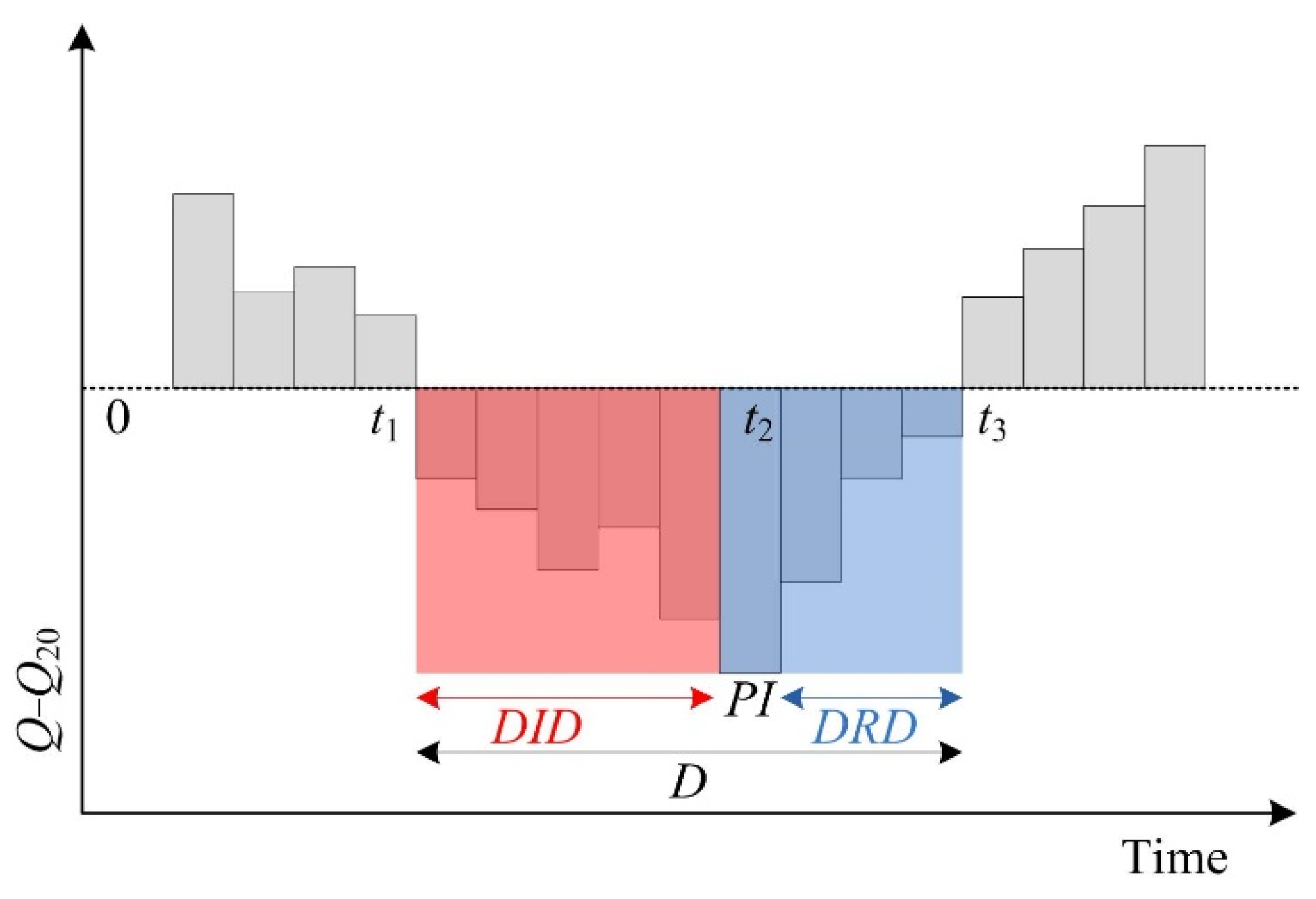
Figure 1. Propagation characteristics of hydrological drought. D is the drought duration; DID and DRD represent drought intensification and recovery durations; and PI is the peak intensity. Red and blue shaded represent intensification and recovery stages of hydrological drought, respectively [13].
Water 14 03219 g001
Figure 2. Location of the Harp Lake catchment (a) and Dongjiang River catchment (b), and their corresponding hydrological monitoring stations.
Water 14 03219 g002
Figure 3. Box-plots for monthly streamflow in different months within a year in the Harp Lake (af) and Dongjiang River (gi) catchment; (a) HP0, (b) HP3, (c) HP3a, (d) HP4, (e) HP5, (f) HP6, (g) Yuecheng, (h) Lantang, and (i) Jiuzhou.
Water 14 03219 g003
Figure 4. Ratio of seasonal streamflow to the total annual streamflow in the Harp Lake and Dongjiang River catchments.
Water 14 03219 g004
Figure 5. The distribution of streamflow deficit (i.e., the time series of Q − Q20 ≤ 0) within a year, based on a fixed drought threshold (FDT) (a,c) and variable drought threshold (VDT) (b,d) at the HP0 station of Harp Lake catchment (a,b) and Dongjiang River catchment (c,d). The scaled legend bar on the right indicates the streamflow deficit in that month. The black grid in the figure shows that the streamflow deficit was lower than the minimum in the scaled legend.
Water 14 03219 g005
Figure 6. The onset, peak intensity (PI), and termination time of hydrological drought (HD) events within a year based on the fixed drought threshold (FDT) (a,c) and variable drought threshold (VDT) (b,d) at the HP0 station of the Harp Lake catchment (a,b) and Lantang station of the Dongjiang River catchment (c,d).
Water 14 03219 g006
Figure 7. The relationship between the duration and severity of hydrological drought (HD) events at the HP0 station of the Harp Lake catchment (ad) and Dongjiang River catchment (eh) based on a fixed drought threshold (a) and (e) and variable drought threshold (b) and (f) methods; the linear change trend for the HD intensity identified using a fixed drought threshold (c) and (g) and variable drought threshold (d) and (h), respectively.
Water 14 03219 g007
Figure 8. The change trend of annual streamflow in at the HP0 site of Harp Lake (a) and the Lantang station of the Dongjiang River (b) catchment.
Water 14 03219 g008
Table 1. The data for this study.
CatchmentStationTimescaleStreamflow Records
Harp LakeHP0Monthly1978–2019
HP3Monthly1978–2019
HP3aMonthly1978–2019
HP4Monthly1978–2019
HP5Monthly1978–2019
HP6Monthly1978–2019
Dongjiang RiverYuechengMonthly1960–2006
LantangMonthly1958–2015
JiuzhouMonthly1960–2006
Table 2. Averages for the propagation characteristics of hydrological drought (HD) events with a duration longer than 3 months at the HP0 station of Harp Lake and the Lantang station of the Dongjiang River catchment; FDT and VDT represent fixed and variable drought threshold methods, respectively; D and S are the duration and severity of HD; DID and DRD are the HD intensification and recovery duration.
CatchmentMethodsD (Month)S (m3/s)DIDDRD
Harp LakeFDT3.910.0542.641.27
VDT4.670.0623.331.33
Dongjiang RiverFDT5.0510.623.161.89
VDT5.4723.582.62.87
Publisher’s Note: MDPI stays neutral with regard to jurisdictional claims in published maps and institutional affiliations.