Article

Evaluation of Soil and Water Conservation Function in Dingxi City, Upper Yellow River Basin

Institute of Geographic Sciences and Natural Resources Research, Chinese Academy of Sciences, Beijing 100101, China
Water 2022, 14(18), 2919; https://doi.org/10.3390/w14182919
Submission received: 16 August 2022 / Revised: 13 September 2022 / Accepted: 14 September 2022 / Published: 18 September 2022

Abstract

:
Dingxi City is located in the upper reaches of the Yellow River Basin, at the intersection between the Loess Plateau and West Qinling Mountains. The water and soil conservation function of Dingxi City is very important and have become key constraining factors for economic and social development. Due to the fragmented terrain and landscape patches, high spatial accuracy in the assessment of water and soil conservation is required for proper management. In this study, we introduced an index system for the evaluation of soil and water conservation functions, including various influencing factors. The results showed that area percentages of the five levels (lower, low, medium, high, and higher) in soil conservation were 6.24, 6.25, 23.49, 30.95, and 33.07, respectively, and the areas with higher soil conservation were mainly concentrated in the hilly and gully areas of the Loess Plateau with low vegetation coverage. The percentages of water conservation in the five levels (lower, low, medium, high, and higher) were 40.49, 21.78, 16.66, 7.9, and 13.11, respectively, and the areas with higher water conservation were concentrated in Min County and Zhang County, with the most abundant precipitation and highest vegetation coverage. In addition, functional areas of soil and water conservation had obvious spatial heterogeneity. Among them, the proportion of high-grade functional areas for soil conservation decreased with an increase in precipitation, whereas a high proportion of high-grade functional areas for water conservation was concentrated in areas with precipitation of more than 600 mm. The conflict between agricultural production and ecological protection of soil and water conservation is prominent, and areas with serious conflict are concentrated in the central and northern areas of Dingxi City. Based on this, we suggest a spatial layout guidance for agricultural production and ecological protection, providing a scientific basis for decision-making that supports ecological protection and high-quality sustainable development in Dingxi City.

1. Introduction

Soil and water conservation are the typical ecosystem services of river basins [1]. Soil conservation is the ability of an ecosystem to prevent erosion and store sediment through its structures and processes [2]. Soil conservation services play an integral role in avoiding droughts and floods and targeting ecological improvements [3]. Water conservation is the ability of an ecosystem to protect its internal hydrological process, meeting the water demand and contributing to flood storage, flood peak reduction, and water purification [4]. The study of soil and water conservation has great value in maintaining ecosystem stability and ensuring high-quality economic and social development [5].
Research on soil and water conservation has become a hot issue in international ecology [6,7,8,9]. Since the Universal Soil Erosion Equation (USLE) for soil erosion was proposed by the U.S. Department of Agriculture [10], many scholars have studied the soil retention capacities of different areas applying different methods. Fu et al. evaluated the soil conservation function of Loess Plateau ecosystems based on land cover change and USLE modeling, and results showed that vegetation restoration greatly improved soil conservation, and changes in soil conservation functions were crucial to regional ecological restoration [11]. RUSLE was also used for the mountainous areas of Kyrgyzstan, leading to mapping of the Kyrgyzstan soil erosion model [12]. The WEPP model was used for Ansai to assess the ability to predict runoff and soil erosion on the steep slopes of hilly gullies in the Loess Plateau of China [13]. To evaluate the capacity of soil erosion in three different tillage systems (monopoly, chisel plow, and no-till), Bhuyan et al. employed three erosion prediction models ( the WEPP, Erosion Productivity Impact Calculator (EPIC), and Areal Nonpoint Source Watershed Environment Response Simulation (ANSWERS)) [14]. In addition to the above soil modeling methods, evaluation methods based on hierarchical analysis, frequency analysis, expert consultation, gray cluster analysis, and other indicator analysis methods are also widely used to measure soil conservation functions [15].
Similar to soil conservation, water conservation is important in social and ecological research [16,17]. Water conversation originated from the study of forest ecosystems, where scholars measured the actual parameters of the forest to calculate water retention rate [18]. With the expansion of the study area, modeling tools were gradually applied in the assessment of water content. Hu et al. used the Integrated Valuation of Ecosystem Services and Trade-offs (InVEST) model to assess water conservation in Dongting Lake and Poyang Lake wetlands [19]. Many scholars have also applied InVEST to ecological service studies in the Chubut River basin [20], northern Israel [21], etc. The hydrological model WEP-l combined with the water balance model revealed the response of water conversation to climate change in the Yangtze River basin [22]. In addition, some hydrological models with physical mechanisms, such as the SWAT model [23], have also been applied in water conservation studies.
In China, especially in the Loess Plateau region, soil and water conservation have received widespread attention [24,25]. Dingxi City is located at the intersection of the Loess Plateau and western Qinling Mountains. Its ecosystem function is important and vulnerable. On the one hand, the hilly-gullied loess region in Dingxi City is widely distributed, and its soil conservation is a key factor in ecological stability; Dingxi City is also the birthplace of an important tributary of the Yellow River, and its water conservation is extremely important. On the other hand, Dingxi City is in an ecological transition zone in a semi-arid area. The ecosystem is extremely sensitive and vulnerable, easily damaged, and difficult to recover, which highlights the importance of strengthening the ecological protection in this area. In addition, Dingxi City is in an ecotone between farming and animal husbandry. There is a high intensity of agricultural activities, and they are mainly affected by climate change. In the past 10 years or so, the precipitation in this area has significantly increased and ecological quality has improved. However, with the increase in precipitation, farmland areas also increased by 52.5% from 2008 to 2018. The large-scale expansion of farmland has occupied ecological land and a large amount of water resources, which could aggravate regional soil erosion and affect the water conservation in the river. To solve this conflict between agricultural production and ecological protection, it is necessary to identify the important functional areas of water and soil conservation in Dingxi City. As the terrain and landscape patches of Dingxi City are extremely fragmented, high-precision assessments of ecological function are required for proper management, and are currently unavailable in the literature.
In this study, the importance of soil and water conservation function was evaluated on a 100 m grid scale, and key areas of soil and water conservation were identified. The spatial overlap between these areas and their relationship with agricultural activities are discussed. Furthermore, we provide guidance for the coordinated development of agricultural production and ecological protection. The results of this study can provide a scientific basis for the ecological protection and agricultural management of Dingxi City, which has great ecological importance and vulnerability.

2. Materials and Methods
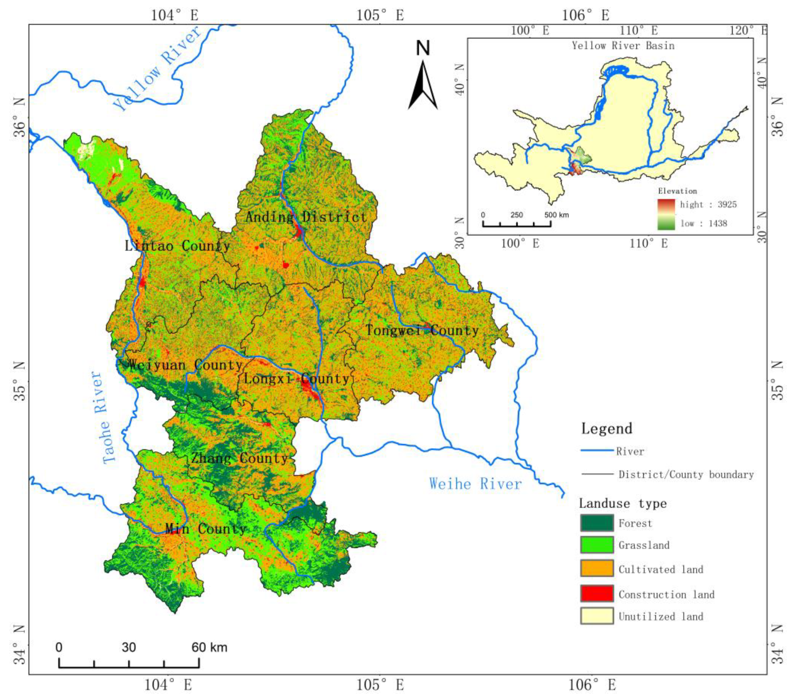
2.1. Study Areas

Dingxi City is located in the middle of Gansu Province, between 34°26′–35°35′ N and 103°52′–105°13′ E (Figure 1). It covers a total area of 19,600 square kilometers. The overall topography of the city fluctuates greatly, with a complex terrain, mountains that are vertical and horizontal, and a greatly varying climate. The central and northern parts of the city are dry and less rainy, whereas the southern area is cold and damp. The average annual temperature is 5.7–7.7 °C. Mean annual precipitation is about 500 mm, decreasing from south to north (Figure 2b). Evaporation is as high as 1400 mm or more. Using the Weihe River as the boundary, the geography is roughly divided into two natural types: the loess hilly and gully areas of the north and alpine and humid areas of the south. The central and northern parts account for 60% of the total area, and is in a middle temperate semi-arid zone with low precipitation, sufficient sunshine, and relatively high temperatures. Anding District, Longxi County, Tongwei County, Lintao County, and Weiyuan County are located in the loess hilly and gully area in the upper reaches of the Loess Plateau (Figure 2a), including three water systems and terraces at all levels of their main tributaries. Lintao County and Weiyuan County are part of the Taohe River Basin, the largest tributary of the Yellow River, and most of Anding District is located in the Guanchuan River Basin. The warm temperate semi-humid areas have high altitudes and low temperatures. Zhang County and Min County are located in the West Qinling Mountains, and belongs to the north-south transitional zone of China. The southeast of Min County belongs to the Jialing River Basin, a tributary of the Yangtze River. It is a sensitive area for the global climate change response. This area is rich in biodiversity, and a key protected area for surface water sources in Dingxi City. There are various soil types in the study area, including approximately six types of primary soil, arid soil, and alpine soil, among which the primary and calcareous soils are mainly distributed in the northern Loess plateau area, in Anding District and Tongwei County, and semi-eluvial and a small amount of eluvial soils are distributed in most areas of Zhang County and Min County in the south. The ecological environment of Dingxi area is fragile. Due to the long-term lack of water resources, poor land resources, and low soil organic matter content, the situation is especially serious in the northern part of the region. In addition, many artificial reclamations of steep slopes into cultivated land have caused serious soil loss and surface and groundwater loss in this area. This has contributed further to the sharp deterioration in the ecological environment and loss of biodiversity. The city‘s soil erosion area is 16,726.6 km2, accounting for 85.3% of the total land area. Serious soil erosion, shortage of water resources, a harsh ecological environment, and fragile agricultural foundations have become the main "bottlenecks" restricting the healthy development of the local economy and society for a long time. The task of protection and governance is extremely arduous, seriously restricting the development of industrial and agricultural production and improvement in the ecological environment.

2.2. Data Sources

Soil erosion intensity classification data in a kilometer grid, Normalized Difference Vegetation Index (NDVI) data in a kilometer grid, and DEM data in a 30 m grid were downloaded from the Resource and Environment Data Center, Chinese Academy of Sciences (https://www.resdc.cn/ accessed on 15 Sep 2022). The land use vector map (1:50,000 scale) came from the Second National Land Use Survey evaluation in 2018. All the above data were resampled to a 100 m grid using a bilinear interpolation algorithm in ArcGIS. The precipitation and evaporation from 1980 to 2015 were derived from the observation data of meteorological stations in Dingxi City and surrounding areas and interpolated to a 100 m grid by the Kriging method.

2.3. Methods

Soil and water conservation refer to the ability of ecosystems to conserve soil and water resources, prevent and mitigate disasters, and improve the ecological environment [26,27,28,29]. Due to the importance of existing data and the difficulty in obtaining the data, basic and representative data points were selected to reflect soil loss status, soil quality status, and water conservation capacity.

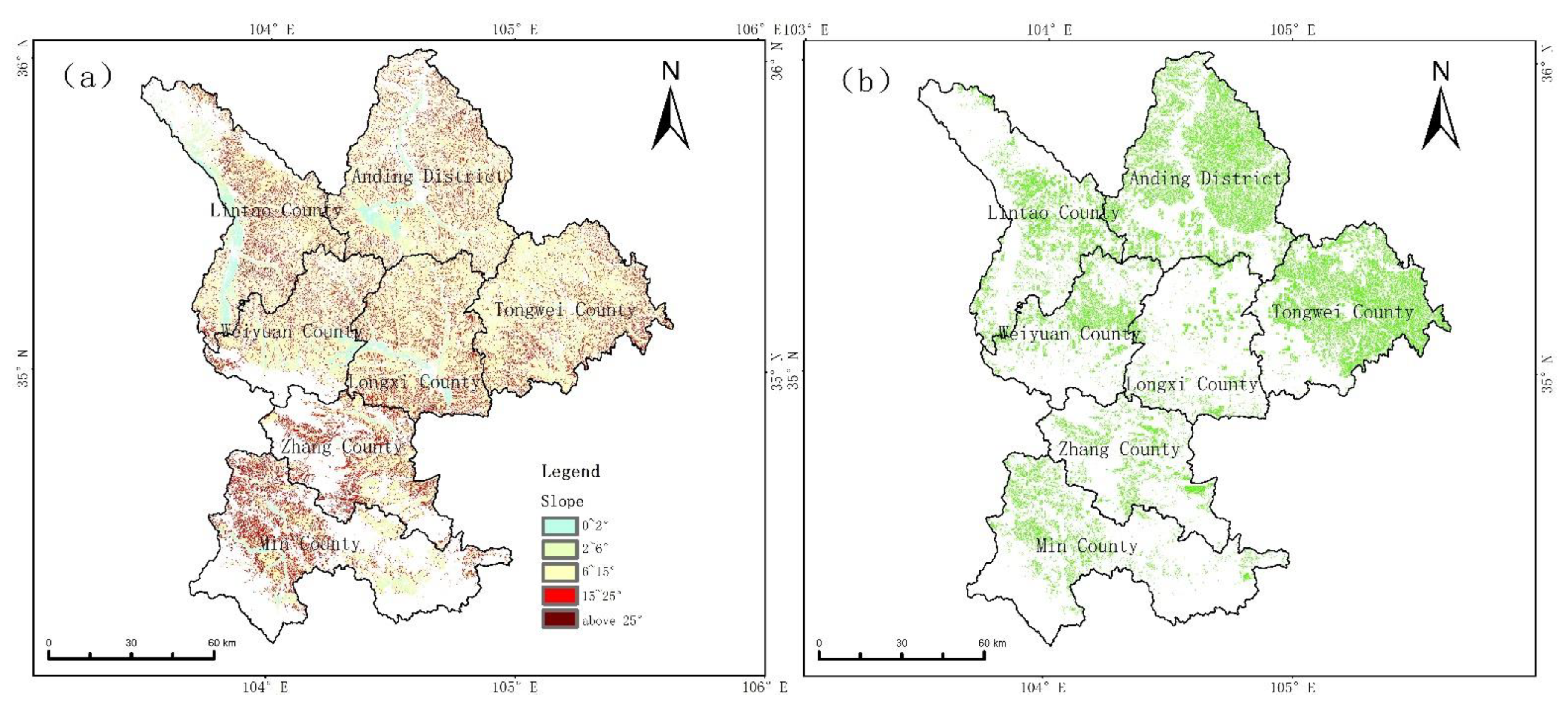
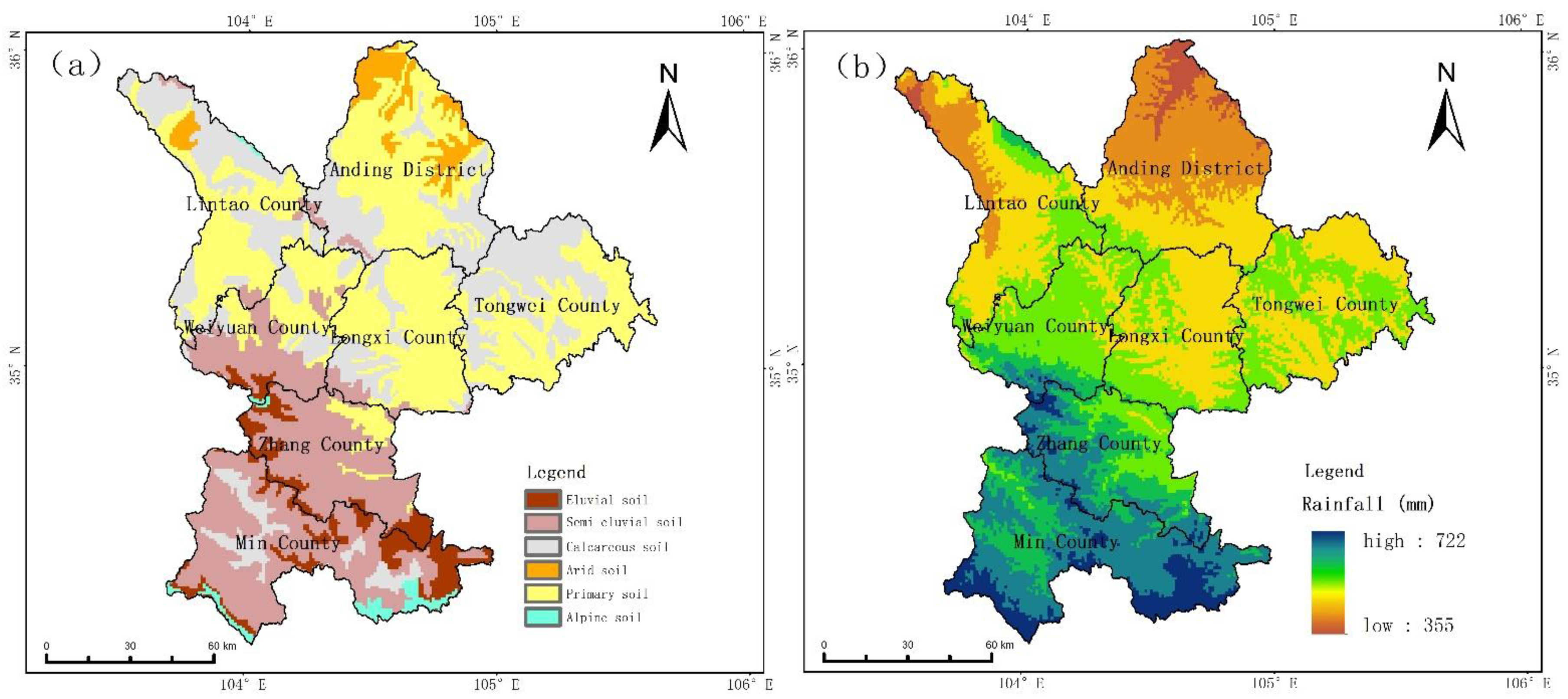
2.3.1. Establishment of the Soil Conservation Evaluation Index System

The soil conservation evaluation index system comprehensively calculates and analyzes evaluation factors such as soil erosion intensity, vegetation coverage, and topographical features, and divides the ecosystem into five grade areas of soil conservation function (lower, low, medium, high, and higher, and assigned a value from 1 to 5, according to level of importance). Soil erosion intensity was mainly reflected in the soil erosion intensity parameter (SEI). Soil erosion destroys the soil structure by destroying the surface soil, which in turn causes soil loss [30,31]. The slope is the most significant factor affecting soil erosion. Erosion is proportional to the steepness of the slope and increasing the slope will increase the risk of gravity erosion [32]; vegetation coverage plays a key role in controlling soil erosion [33], and vegetation directly hits the ground and reduces runoff scouring by isolating rainfall. An increase in vegetation coverage intercepts rainfall, reducing rainfall energy, and thus, reducing the erosive force. Based on the actual situation of Dingxi City and relevant planning and design results of soil and water conservation, we formulated evaluation and classification standards, and the classification results were appropriately adjusted [34].
In this study, soil loss intensity, slope, and NDVI were used as to comprehensively evaluate the level of soil conservation importance in Dingxi City. The Soil Conservation Importance Index (SCII for short, the same below) was measured as the product of these three factors. The formula for calculating the terrain weighting factor and for the vegetation coverage factor, based on NDVI, are as follows:
SCII   =   SEI × F s l p × K n d v i
[ F s l p ] = MIN ( 1 , S L P 30 )
K n d v i = N D V I i N D V I m i n N D V I m a x N D V I m i n
In the formula, SEI is the soil erosion intensity parameter, and the assignment method is shown in Table 1; F s l p is the terrain weighting factor based on the slope, SLP is the slope value, which is the smaller value between SLP/30 and 1; K n d v i is the vegetation coverage weighting based on NDVI. N D V I i   is the NDVI index of the evaluation unit; N D V I m i n and N D V I m a x are the minimum and maximum values of NDVI in the study area, respectively. Based on the terrain factors in the study area, the slope extraction results were reclassified and assigned. The more serious the degree of soil loss caused by the terrain factors, the greater the assigned value; the vegetation coverage was a key inhibitory factor affecting soil erosion. The main effect of soil loss control measure is directly reflected in vegetation changes, so vegetation coverage is an important regional environmental factor for soil conservation monitoring.

2.3.2. Establishment of the Water Conservation Evaluation Index System

The water conservation capacity ecosystem of Dingxi City is composed of the water conservation capacity of the surface cover layer and soil water conservation capacity, which are related to the surface cover state, vegetation type and coverage, litter composition, and soil thickness. Water conservation capacity is closely related to factors such as soil physical properties and is the result of the comprehensive effect of vegetation and soil [35]. According to a method of evaluating the importance of water conservation function at home and abroad [36], combined with the coexistence of the gully area of the Loess Plateau and the West Qinling Mountains in Dingxi City, three factors, namely the runoff modulus, ecosystem type, and characteristic vegetation, were selected as influencing water sources. These three factors were assigned the same weight in the assessment of water conservation in Dingxi City, and the assessment grades were appropriately adjusted in combination with the design results of water conservation-related planning.
The water conservation importance index (WCII for short, shown below) mainly considers three factors: the basin runoff modulus, ecosystem type, and characteristic vegetation. Similar to the SCII, five important grade areas are divided. The calculation formulas are as follows:
[ WCII ] = R × K e c o × A L T
A L T = M a x ( H i ,   H c h a r a c t e r i s t i c   v e g e t a t i o n ) / H m a x
In these formulae, R refers to the yield per unit area (mm), and Formula 6 (Fu Baopu equation) is used according to the observation data of precipitation and evaporation; K e c o is the land cover factor based on the type of ecosystem. The larger the value of forest, grassland, and other land cover types, the smaller the value of cultivated land and urban construction land. Table 2 shows the specific assignment method of the land surface factor; ALT is based on elevation. H i is the pixel elevation value; H m a x is the maximum altitude of the evaluation area; H Feature   Vegetation vegetation is the elevation value of the vegetation with the largest distribution area among the vertical zonal vegetation in the evaluation area, which is 2000 m in this study. The characteristic vegetation factor based on elevation considers the influence of main local vegetation on the water conservation function.
The runoff modulus is calculated using the Fu Baopu equation [37], the formula is as follows:
R = P     E = P · [ 1 + ( E 0 P ) ω ] 1 ω E 0

3. Results and Discussions

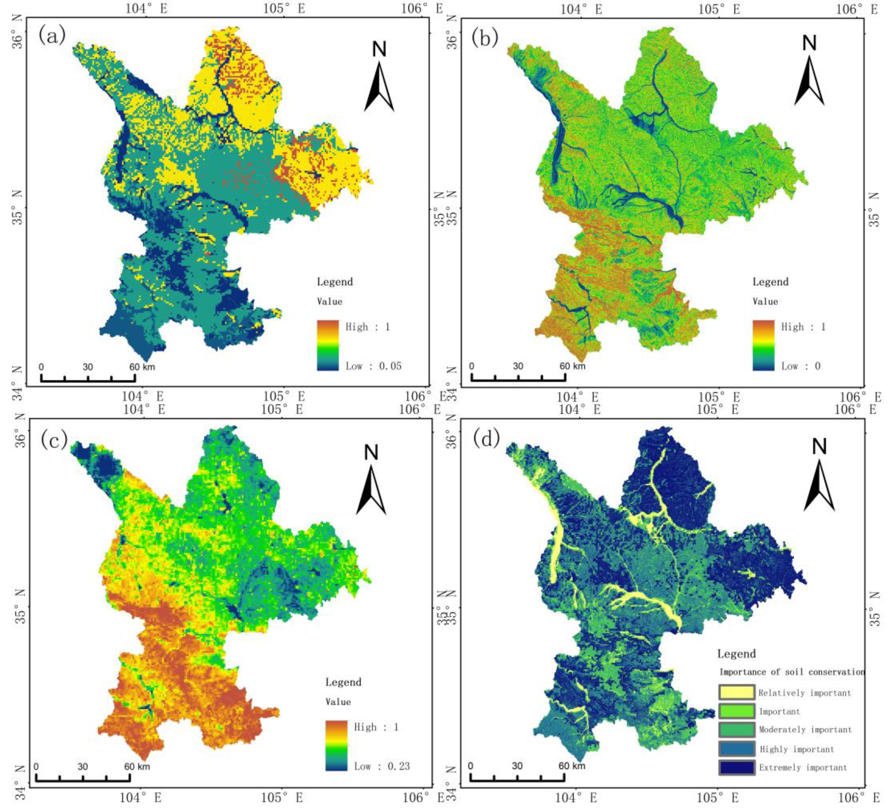
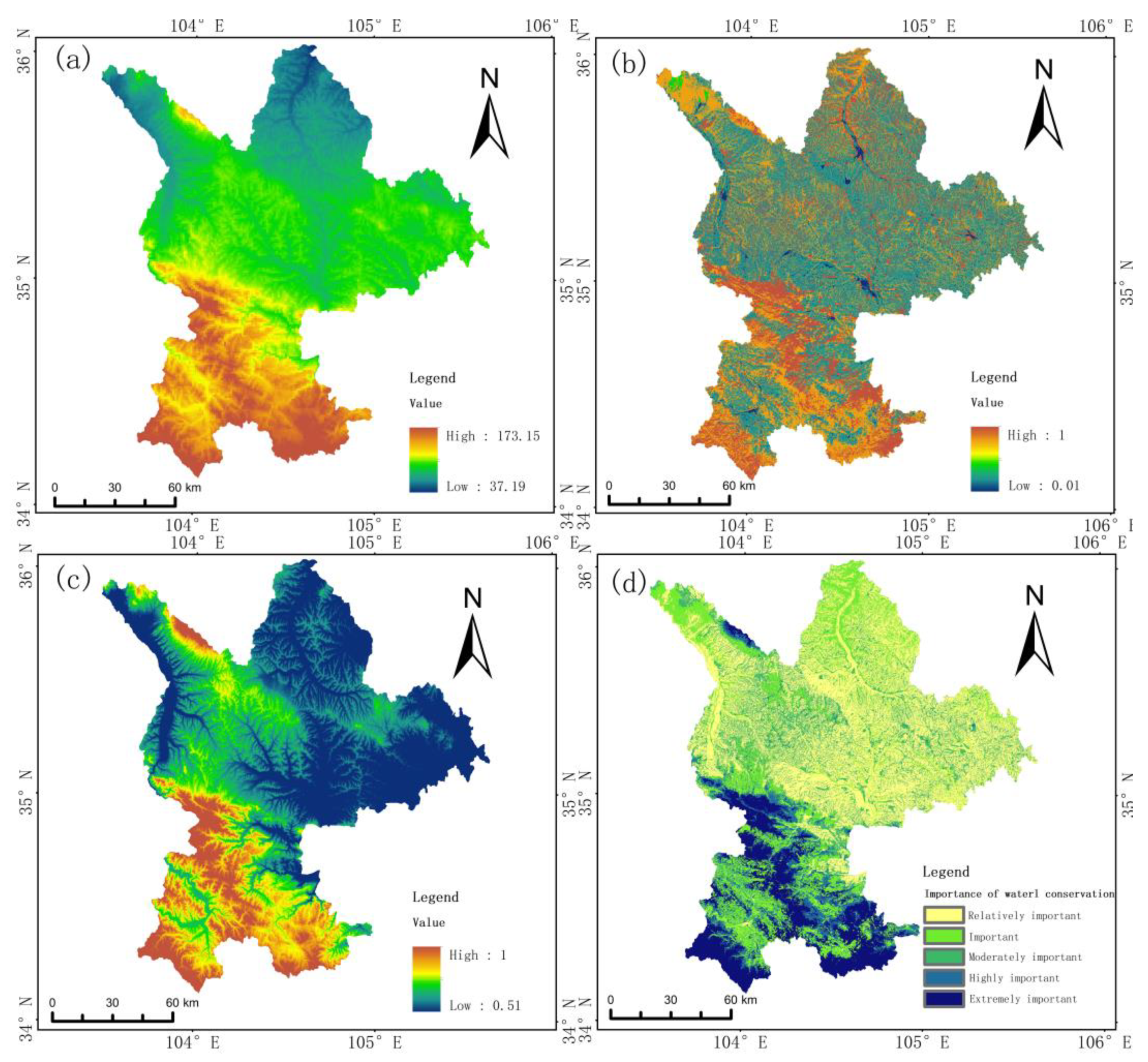
3.1. Soil Conservation Function Evaluation

Soil erosion destroys the soil structure and changes soil hydraulic properties, which in turn causes soil loss and a series of negative consequences [38,39]. For a long time, affected by the influence of natural and human activities, Dingxi City has witnessed a deterioration in the ecological environment, infertile soil, as well as a prominent soil erosion problem. The statistics of the annual average soil erosion modulus were as high as 5527 t/km. According to Figure 3a, the whole soil erosion intensity in Dingxi City shows a spatial distribution characteristic of being low in the south and high in the north, with Anding District and Tongwei County being soil erosion-prone areas, whereas remaining areas generally have low soil erosion intensity. In addition, vegetation cover is a key inhibitory factor affecting soil erosion and is also a critical element in the evaluation of the need for soil conservation [40]. As shown in Figure 3c, the distribution of vegetation cover and soil erosion intensity are basically the same, which implies that Anding District and Tongwei County are still prone to soil erosion. Generally, areas with a steeper slope, profile curvature, surface roughness, and located closer to the gully network are more susceptible to silo erosion [3,41,42]. Thus, when only considering the topography factor (Figure 3b), Zhang County and Min County are more exposed by soil erosion than areas north of Zhang County. However, this is clearly contrary to results based on the distribution of soil erosion intensity and vegetation cover, indicating that a single factor may not reflect the true situation of soil erosion. Based on single-factor evaluation, the regional soil conservation importance indicator was obtained by comprehensive measurement and divided into five grades, i.e., lower, low, medium, high, and higher, and the corresponding area percentages were 6.24, 6.25, 23.49, 30.95, and 33.07%, respectively. Overall, more than 60% of Dingxi City were important areas for soil conservation, mainly in the northern area, and the importance of soil conservation in the southern areas were low (Figure 3d). The northern Anding District, eastern Tongwei County, and northwestern part of Lintao County held the highest level of importance for soil conservation. With the development of ravines, strong soil erosion, and low vegetation coverage, these areas are inclined to serious soil erosion. On the contrary, Southern Weiyuan County, Zhang County, and Min County were under the joint influences of a steep slope, high vegetation cover, and light soil erosion intensity, and had ecological environments better than those of the central and northern areas, so the soil erosion problem was less severe and the importance of soil conservation was lower. Therefore, in areas with a high soil conservation grade, the comprehensive management of the catchment should be strengthened, with emphasis on implementing sloping land remediation and soil erosion ditch management. It is necessary to implement the “Grain for Green” program in scattered sloping farmlands to mitigate and control the pace of soil erosion.

3.2. Water Conservation Function Evaluation

As presented in Figure 4a, the spatial distribution of the average runoff depth (R) from 1980 to 2015 in Dingxi City faced significant changes. Overall, the R is characterized as being low in the north and high in the south. For example, the R is relatively large in Min County and Zhang County, with a maximum of 173 mm (i.e., runoff modulus of 173,000 m3/km2), but is smaller in the five northern counties, with a minimum runoff modulus of 37,000 m3/km2. The distributions of the characteristic vegetation and ground cover factors also show similar spatial distributions as the runoff depth, with high values concentrated in most areas of Zhang County and Min County (Figure 4b,c). Based on the results of single factor evaluation, the importance of water conservation was measured comprehensively and divided into five levels, i.e., lower, low, medium, high, and higher, with the corresponding area percentages being 40.49, 21.78, 16.66, 7.9, and 13.11%, respectively. It was evident that the water conservation importance of Dingxi City was characterized as being high in the south and low in the north, with most areas in Zhang County and Min County considered high-level in water conservation importance or higher (almost 30 percent, Figure 4d). These areas are dominated by forest ecosystems, which are the main bodies of water conservation, and thus, are important water conservation areas. In contrast, the importance of water conservation in the northern five counties (districts), where there was high human activity and little natural vegetation maintenance, was at the lower or low level. This shows that the water conservation capacities of high vegetation cover areas are superior to low vegetation cover areas, which is in line with the general rule of water conservation capacity of ecosystems. For example, the results of Shi et al. in the Qianshan watershed showed that the forest coverage rate was increased, and the water conservation capacity was improved [43]. Besides, combined with land use type, we find that water conservation capacity presents the characteristics of forest > grassland, water > garden, unused land > cultivated land > construction land (Figure 4c), where some areas have good water conservation capacity due to the presence of parks and urban greenery in urban and built-up areas. This may be related to the effects of different vegetation types on soil structure, soil water-holding capacity, and soil infiltration capacity. A study by Yu et al. proposed that the water conservation capacity of the Liaohe River Basin was broad-leaved forest > mixed coniferous and broad-leaved forest > coniferous forest > shrub forest > grassland > farmland [44]. The roots of the vegetation distributed in the farmland were underdeveloped, soil pores were not developed, and infiltration capacity was poor. At the same time, due to long-term cultivation, the soil surface was seriously damaged and soil water-holding capacity was poor, which led to worse water conservation capacities in the farmland than other regions.
Areas with high water conservation grades were mainly distributed in mountainous areas, where the impact of human activities were relatively low, but there were also problems of farming on steep slopes, which led to the fragmentation of natural ecological patches. It is important to strengthen the ecological conservation of the catchment, increase implementation of the “Grain for Green” project, and practice follow-up management. It is vital to gradually improve water conservation through a natural, restoration-based approach.

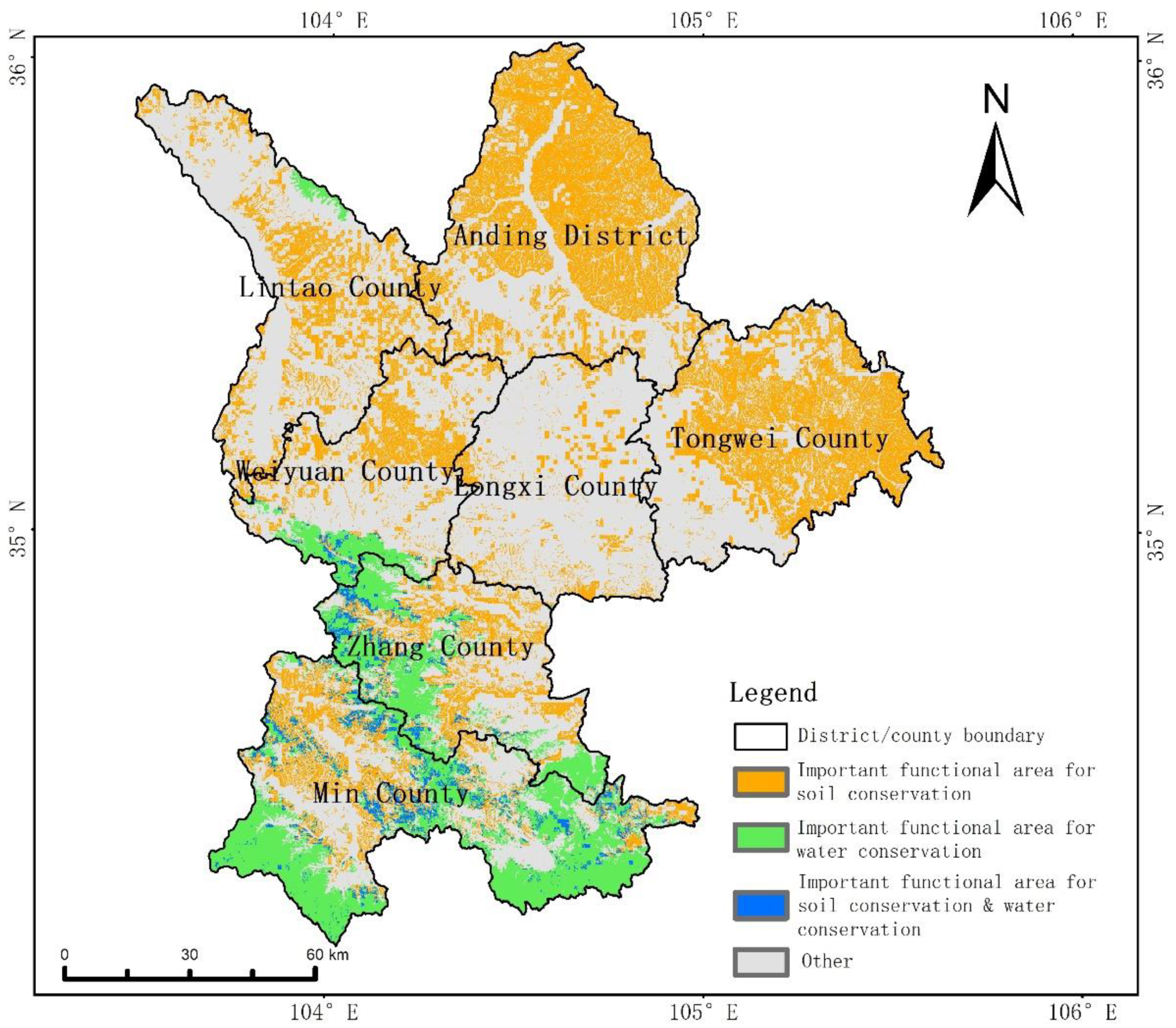
3.3. Distribution Characteristics of Ecological Protection Important Functional Areas for Soil Conservation and Water Conservations

3.3.1. Spatial Distribution of Functional Areas and Its Relationship with Precipitation

We analyzed the role of precipitation in the distribution of soil and water conservation functional areas. As shown in Figure 2b, the average annual precipitation in Dingxi City ranges from 355 to 722 mm, and the distribution generally trends with more precipitation in the south and less in the north, exhibiting opposite (similar) spatial features to soil (water) conservation functional areas. As shown in Figure 5 and Table 3, as precipitation increases, the percentage area of very important soil conservation zones gradually decreases. This is mainly attributed to poor vegetation cover, gullies, and high soil erosion intensity over a long period of time. Thus, in areas with less precipitation, such as Anding District and Tongwei County, high priority must be given to the practice of soil conservation. On the contrary, in areas with higher precipitation (especially in areas with more than 600 mm), such as Min County and Zhang County, the importance of water conservation function is very prominent. Previous research has also demonstrated that precipitation is the main influencing factor on soil and water conservation. For example, a 1% change in precipitation leads to a 2% change in sediment loads and a 1.3% change in water discharge in eight large Chinese rivers [45]. Furthermore, the amount, intensity, and variation patterns of precipitation can cause different effects in various regions [46,47,48]. The results of this study shows that the spatial characteristics of Dingxi City are closely related to the spatial patterns of precipitation [42].
In addition, soil and water conservation of Dingxi City were superimposed on the areas with highest-level importance to analyze their spatial characteristics. As shown in Figure 5, there are obvious spatial heterogeneity characteristics. Important functional areas for soil conservation accounted for 31.1% of the city and were mainly located in Anding District and Tongwei County in the north of Dingxi, whereas important functional areas for water conservation accounted for 11.1% and were mainly located in Zhang County and Min County in the south of the city. There was very little spatial overlap between the two, and the areas occupied by the important soil conservation/water conservation function was only 2% of the regional area, and was concentrated in an area where the precipitation was 600–700 mm. Dingxi City is located in the semi-humid and semi-arid climate zone of the Loess Plateau. Results on the spatial and temporal distribution of soil and water conservation and net primary productivity services in the Loess Plateau ecosystem by Wang et al. showed that for the Loess Plateau, there is a trade-off (negative correlation) between soil conservation and water conservation in semi-humid and semi-arid climate zones [49]. This is similar to the large spatial heterogeneity of soil and water conservation functional zones in Dingxi City obtained in our study.

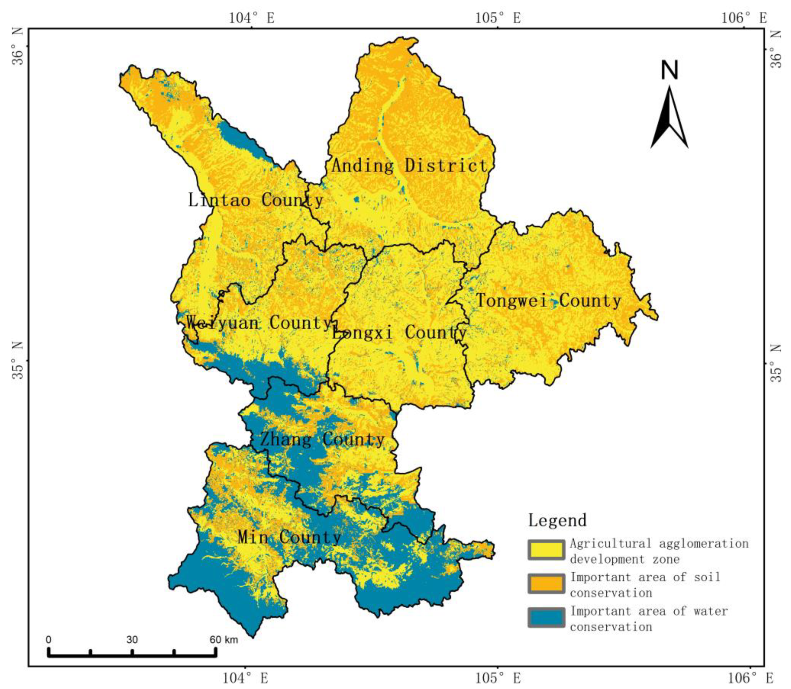
3.3.2. Spatial Coupling between Ecological Protection Functional Areas and Cultivated Land

Different types of land use show different effects on soil erosion, and among them, the influence of agricultural production on ecological protection in Dingxi City cannot be overlooked [50]. The conflict between agricultural production and ecological protection in Dingxi City is prominent. About half of the land area in Dingxi City is farmland, of which 33.0% is in the higher grade area of soil conservation function, which is the main source of conflict between regional development and ecological protection. Figure 6 shows the slope grade of farmland and its conflict spots with a higher grade area of soil conservation function; the coupling relationship between them is counted in Table 4. Among the 9326.5 km2 of cultivated land in Dingxi City, 1815.9 km2 of the land has a slope below 6°, and the area of conflict with the higher grade area of soil conservation function is small, only 27.2 km2. A land area of 5176.7 km2 has a slope between 6 and 15°, and 1662.8 km2 of this has a higher grade area of soil conservation function, with the proportion being 32.1%. Of the 2153.5 km2 of farmland with a slope of 15–25°, 1234.3 km2 is the higher grade area of soil conservation function, with a proportion of 57.3%. Among the 180.4 km2 of farmland with a slope above 25°, 152.0 km2 is the higher grade area of soil conservation function, with a proportion of 84.3%. Previous studies indicated that agricultural soil erosion could cause severe loss of soil water and strongly influence available water content [39,51]. Considering the current situation of farmland in Dingxi City, it is necessary to take appropriate measures to protect crops and food security. The conflict areas were mainly distributed in the north-central parts of Dingxi City, among which the distribution was more intensive in Anding County, Tongwei County, the northern part of Commissioner County, and the eastern part of Lintao County, whereas conflict areas in Longxi County, Zhang County, and the central-eastern part of Min County were relatively few and scattered.
Coordinating the conflict between agricultural production and ecological protection has become an urgent problem in the sustainable development of Dingxi City. Regional control was taken seriously in China. A county-based major function oriented zoning was issued in 2010, which designated Tongwei County as an important ecological functional area for soil and water conservation, whereas all other counties were divided into major agricultural production areas. The results of this study show that there is a lot of territorial space with important soil and water conservation functions besides Tongwei County. In addition, agricultural development activities have heavily crowded out the important functional areas of soil conservation. Therefore, there needs to be higher precision spatial planning because the county-based functional zoning does not meet management requirements. In order to solve the conflict between farmland development and ecological protection, a more accurate geographical functional zoning scheme is needed, and the evaluation of soil and water conservation in this study provides a possible method for this purpose. In our study, we utilized a spatial layout guidance of Dingxi City (Figure 7), where the space was divided into agricultural agglomeration development zones, soil conservation zones, and water conservation zones by combining factors of climatic conditions, land use type, and patch size. In soil conservation zones, cultivated land above 25° should be restored to ecological land, and cultivated land between 15 and 25° should be transformed into terraced fields. In water conservation zones, scattered cultivated land and steeply sloped grassland should be closed to restore the quality of vegetation. These results were recognized by local experts and applied to management practice, indicating that the results of this study were consistent with the real-life situations.

4. Conclusions

In this study, the soil and water conservation functions of Dingxi City was evaluated on a 100 m grid scale, and their spatial distribution characteristics were analyzed. According to our evaluation, we identified important areas for water and soil conservation. Our analysis demonstrated that soil conservation areas were concentrated in Weiyuan County, the northern part of Anding District, and the watershed areas of Taohe River, Guanchuan River, and Weihe River. They have developed gullies, low vegetation cover, and strong soil erosion, being the most serious areas of soil erosion in Dingxi City. Water conservation areas were mainly distributed in Min County and Zhang County, which have the richest precipitation resources and highest vegetation coverage. Their ecological conditions were relatively good, and they were important water conservation areas in the upper reaches of the Yellow River. Soil and water conservation areas had almost no spatial overlaps and obvious spatial variabilities. In different ecological functional areas, ecological management can be targeted to balance economic development and ecological protection. Based on the analysis of spatial distribution characteristics, it was concluded that the distribution of soil and water conservation function in Dingxi City had obvious spatial heterogeneity. Areas with greater precipitation showed fewer higher grade areas of soil conservation, whereas higher grade areas of water conservation were concentrated in areas with precipitation higher than 600 mm. In addition, this study analyzed the spatial distributions of ecological functional areas based on their evaluation results and conflict areas with agricultural activities, which provided a spatial orientation for the agricultural management of Dingxi City.

Funding

This research was funded by the Second Tibetan Plateau Scientific Expedition and Research Program (No. 2019QZKK0406) and National Natural Science Foundation of China (Nos. 41971164; 72050001).

Data Availability Statement

The data presented in this study are available on request from the corresponding author.

Acknowledgments

The author would like to thank Dingxi Development and Reform Commission for the help in field investigation and results demonstration and acknowledge X.Y. Song, H. Wu, and H.X. An, K. Zhou for their technical assistance in laboratory works.

Conflicts of Interest

The author declares no conflict of interest.

References

  1. Zhao, Y.; Wang, Z.; Sun, B.; Zhang, C.; Ji, Q.; Feng, L.; Shi, M. A study on scheme of soil and water conservation regionalization in China. J. Geog. Sci. 2013, 23, 721–734. [Google Scholar] [CrossRef]
  2. Zhao, W.; Liu, Y.; Daryanto, S.; Fu, B.; Wang, S.; Liu, Y. Metacoupling supply and demand for soil conservation service. Curr. Opin. Environ. Sustain. 2018, 33, 136–141. [Google Scholar] [CrossRef]
  3. Sun, W.; Shao, Q.; Liu, J.; Zhai, J. Assessing the effects of land use and topography on soil erosion on the Loess Plateau in China. Catena 2014, 121, 151–163. [Google Scholar] [CrossRef]
  4. Bai, Y.; Ochuodho, T.O.; Yang, J. Impact of land use and climate change on water-related ecosystem services in Kentucky, USA. Ecol. Indic. 2019, 102, 51–64. [Google Scholar] [CrossRef]
  5. Hu, X.; Li, Z.; Nie, X.; Wang, D.; Huang, J.; Deng, C.; Shi, L.; Wang, L.; Ning, K. Regionalization of Soil and Water Conservation Aimed at Ecosystem Services Improvement. Sci. Rep. 2020, 10. [Google Scholar] [CrossRef] [PubMed]
  6. Jiang, P.; Guo, F.; Luo, Y.-C.; Wei, J.; Sun, X.-W.; Wu, G. Water and soil conservation function of typical plantation forest ecosystems in semi-arid region of Western Liaoning Province. Ying Yong Sheng Tai Xue Bao J. Appl. Ecol. 2007, 18, 2905–2909. [Google Scholar]
  7. Naseri, F.; Azari, M.; Dastorani, M.T. Spatial optimization of soil and water conservation practices using coupled SWAT model and evolutionary algorithm. Int. Soil Water Conserv. Res. 2021, 9, 566–577. [Google Scholar] [CrossRef]
  8. Su, S.; Liu, X. The Water Storage Function of Litters and Soil in Five Typical Plantations in the Northern and Southern Mountains of Lanzhou, Northwest China. Sustainability 2022, 14, 8231. [Google Scholar] [CrossRef]
  9. Jia, H.; Wang, X.; Sun, W.; Mu, X.; Gao, P.; Zhao, G.; Li, Z. Estimation of Soil Erosion and Evaluation of Soil and Water Conservation Benefit in Terraces under Extreme Precipitation. Water 2022, 14, 1675. [Google Scholar] [CrossRef]
  10. Wischmeier, W.H. Predicting rainfall erosion losses-a guide to conservation planning. Agric. Handb. 1978, 537, 285–291. [Google Scholar]
  11. Fu, B.J.; Liu, Y.; Lu, Y.H.; He, C.S.; Zeng, Y.; Wu, B.F. Assessing the soil erosion control service of ecosystems change in the Loess Plateau of China. Ecol. Complex. 2011, 8, 284–293. [Google Scholar] [CrossRef]
  12. Kulikov, M.; Schickhoff, U.; GrÖNgrÖFt, A.; Borchardt, P. Modelling soil erodibility in mountain rangelands of southern Kyrgyzstan. Pedosphere 2020, 30, 443–456. [Google Scholar] [CrossRef]
  13. Zheng, F.; Zhang, X.C.; Wang, J.; Flanagan, D.C. Assessing applicability of the WEPP hillslope model to steep landscapes in the northern Loess Plateau of China. Soil Tillage Res. 2020, 197, 104492. [Google Scholar] [CrossRef]
  14. Bhuyan, S.J.; Kalita, P.K.; Janssen, K.A.; Barnes, P.L. Soil loss predictions with three erosion simulation models. Environ. Modell. Softw. 2002, 17, 137–146. [Google Scholar] [CrossRef]
  15. Yao, C.; Wang, J.L.; Li, S.H.; Wang, L.X.; Ma, L.C.; Pan, J.Y.; Gao, F.; Liu, G.J. land degradation dynamic remote sensing monitoring of Fuxian Lake basin. Remote Sens. Technol. Appl. 2016, 31, 388–396. [Google Scholar]
  16. Hu, W.; Li, G.; Li, Z. Spatial and temporal evolution characteristics of the water conservation function and its driving factors in regional lake wetlands—Two types of homogeneous lakes as examples. Ecol. Indic. 2021, 130. [Google Scholar] [CrossRef]
  17. Zhou, B.Y.; Li, Z.W.; Tian, S.M.; You, Y.C. A review on water conservation capacity in Yellow River source region. Adv. Sci. Technol. Water Resour. 2002, 42, 87–93. [Google Scholar]
  18. Li, M.; Liang, D.; Xia, J.; Song, J.; Cheng, D.; Wu, J.; Cao, Y.; Sun, H.; Li, Q. Evaluation of water conservation function of Danjiang River Basin in Qinling Mountains, China based on InVEST model. J. Environ. Manage. 2021, 286, 112212. [Google Scholar] [CrossRef]
  19. Sun, W.; Shao, Q.; Liu, J. Soil erosion and its response to the changes of precipitation and vegetation cover on the Loess Plateau. J. Geog. Sci. 2013, 23, 1091–1106. [Google Scholar] [CrossRef]
  20. Pessacg, N.; Flaherty, S.; Brandizi, L.; Solman, S.; Pascual, M. Getting water right: A case study in water yield modelling based on precipitation data. Sci. Total Environ. 2015, 537, 225–234. [Google Scholar] [CrossRef]
  21. Divinsky, I.; Becker, N.; Bar, P. Ecosystem service tradeoff between grazing intensity and other services—A case study in Karei-Deshe experimental cattle range in northern Israel. Ecosyst. Serv. 2017, 24, 16–27. [Google Scholar] [CrossRef]
  22. Xu, F.; Zhao, L.; Jia, Y.; Niu, C.; Liu, X.; Liu, H. Evaluation of water conservation function of Beijiang River basin in Nanling Mountains, China, based on WEP-L model. Ecol. Indic. 2022, 134. [Google Scholar] [CrossRef]
  23. Cong, W.; Sun, X.; Guo, H.; Shan, R. Comparison of the SWAT and InVEST models to determine hydrological ecosystem service spatial patterns, priorities and trade-offs in a complex basin. Ecol. Indic. 2020, 112. [Google Scholar] [CrossRef]
  24. Huang, L.; Cao, W.; Wu, D.; Gong, G.-L.; Zhao, G.-S. Assessment on the changing conditions of ecosystems in key ecological function zones in China. Chin. J. Appl. Ecol. 2015, 26, 2758–2766. [Google Scholar]
  25. Rao, E.; Ouyang, Z.; Yu, X.; Xiao, Y. Spatial patterns and impacts of soil conservation service in China. Geomorphology 2014, 207, 64–70. [Google Scholar] [CrossRef]
  26. Liu, Z.Q.; Wang, H.Y.; Tian, F.X.; Bao, Y.H.; He, X.B.; Li, H.Z.; Jia, G.D. Estimation of Service Value of Soil and Water Conservation Function in Dongzhi Tablelan, Qingyang City of Gansu Province. Bull. Soil Water Conserv. 2018, 38, 168–173. [Google Scholar]
  27. Pang, J.; Liu, X.; Huang, Q. A new quality evaluation system of soil and water conservation for sustainable agricultural development. Agric. Water Manag. 2020, 240. [Google Scholar] [CrossRef]
  28. Chen, Y.; Gong, A.; Zeng, T.; Yang, Y. Evaluation of water conservation function in the Xiongan New Area based on the comprehensive index method. PLoS ONE 2020, 15, e0238768. [Google Scholar] [CrossRef]
  29. Wang, X.; Li, X.; Wang, J. Urban Water Conservation Evaluation Based on Multi-grade Uncertain Comprehensive Evaluation Method. Water Resour. Manag. 2017, 32, 417–431. [Google Scholar] [CrossRef]
  30. Cai, Q.G.; H, J.J.; Tian, L. Cou-pling Relationship between Soil Erosion Control Paradigm and Ecology Theory. Prog. Geogr. 2007, 26, 11–20. [Google Scholar]
  31. Wang, D.; Li, Z.; Zeng, G.; Nie, X.; Liu, C. Evaluation of Regionalization of Soil and Water Conservation in China. Sustainability 2018, 10, 3320. [Google Scholar] [CrossRef]
  32. Chen, H.Y. Evaluation of the importance of soil and water conservation function with forest ecosystem in Yunxian County, Yunnan. Shaanxi For. Sci. Technol. 2022, 50, 50–55. [Google Scholar]
  33. Xu, X.L.; Ma, K.M.; Fu, B.J.; Liu, X.C.; Huang, Y.; Qi, J. Research review of the relationship between vegetation and soil loss. Acta Ecol. Sin. 2006, 26, 3137–3143. [Google Scholar]
  34. Fan, J. Post-Earthquake Restoration and Reconstruction in Ludian: Evaluation of Resources and Environment Carrying Capacity and Research on Sustainable Development; Science Press: Beijing, China, 2016. [Google Scholar]
  35. Leprieur, C.; Kerr, Y.H.; Mastorchio, S.; Meunier, J.C. Monitoring vegetation cover across semi-arid regions: Comparison of remote observations from various scales. Int. J. Remote Sens. 2000, 21, 281–300. [Google Scholar] [CrossRef]
  36. Bai, Y.; Chu, D.; Tian, L.; Feng, Y.; Zhang, Z. Assessing the importance of water conservation function in Wuhan City circle. J. Geo-Inf. Sci. 2014, 16, 233–241. [Google Scholar]
  37. Fu, B.P. On the calculation of the evaporation from land surface. Chin. J. Atmos. Sci. 1981, 5, 23–31. [Google Scholar]
  38. Gu, Z.; Xie, Y.; Gao, Y.; Ren, X.; Cheng, C.; Wang, S. Quantitative assessment of soil productivity and predicted impacts of water erosion in the black soil region of northeastern China. Sci. Total Environ. 2018, 637, 706–716. [Google Scholar] [CrossRef]
  39. Ouyang, W.; Wu, Y.; Hao, Z.; Zhang, Q.; Bu, Q.; Gao, X. Combined impacts of land use and soil property changes on soil erosion in a mollisol area under long-term agricultural development. Sci. Total Environ. 2018, 613, 798–809. [Google Scholar] [CrossRef]
  40. Grizzetti, B.; Lanzanova, D.; Liquete, C.; Reynaud, A.; Cardoso, A.C. Assessing water ecosystem services for water resource management. Environ. Sci. Policy. 2016, 61, 194–203. [Google Scholar] [CrossRef]
  41. Hou, J.; Fu, B.; Wang, S.; Zhu, H. Comprehensive analysis of relationship between vegetation attributes and soil erosion on hillslopes in the Loess Plateau of China. Environ. Earth Sci. 2014, 72, 1721–1731. [Google Scholar] [CrossRef]
  42. Li, Z.; Fang, H. Impacts of climate change on water erosion: A review. Earth Sci. Rev. 2016, 163, 94–117. [Google Scholar] [CrossRef]
  43. Shi, Q.; Zhang, J.C.; Zhuang, J.Y.; Gu, Z.Y.; Wu, Y.W.; Liu, X. Impact of forest vegetation change on runoff in Qianshan watershed. J. Nanchang Inst. Technol. 2014, 33, 11–15. [Google Scholar]
  44. Yu, Z.L.; Fu, S.C.; Wang, Z.M.; Pan, Y.Y.; Yuan, J.Q.; Yang, F.; Zhang, D.W. Water conservation capacity of different vegetation types in Liaohe River basin of Jilin province. Soil Water Conserv. China 2022, 07, 51–55. [Google Scholar]
  45. Lu, X.X.; Ran, L.S.; Liu, S.; Jiang, T.; Zhang, S.R.; Wang, J.J. Sediment loads response to climate change: A preliminary study of eight large Chinese rivers. Int. J. Sediment Res. 2013, 28, 1–14. [Google Scholar] [CrossRef]
  46. Tang, J.L.; Cheng, X.Q.; Zhu, B.; Gao, M.R.; Wang, T.; Zhang, X.F.; Zhao, P.; You, X. Rainfall and tillage impacts on soil erosion of sloping cropland with subtropical monsoon climate—A case study in hilly purple soil area, China. J. Mt. Sci. 2015, 12, 134–144. [Google Scholar] [CrossRef]
  47. Bangash, R.F.; Passuello, A.; Sanchez-Canales, M.; Terrado, M.; Lopez, A.; Javier Elorza, F.; Ziv, G.; Acuna, V.; Schuhmacher, M. Ecosystem services in Mediterranean river basin: Climate change impact on water provisioning and erosion control. Sci. Total Environ. 2013, 458, 246–255. [Google Scholar] [CrossRef]
  48. Maeda, E.E.; Pellikka, P.K.E.; Siljander, M.; Clark, B.J.F. Potential impacts of agricultural expansion and climate change on soil erosion in the Eastern Arc Mountains of Kenya. Geomorphology 2010, 123, 279–289. [Google Scholar] [CrossRef]
  49. Wang, X.Z.; Wu, J.Z.; Wu, P.X.; Shang, G.Z.P.; Deng, L. Spatial and temporal distribution and trade-off water conservation, soil conservation and NPP services in the ecosystems of the Loess Plateau from 2000 to 2015. J. Soil Water Conserv. 2021, 35, 114–121+128. [Google Scholar]
  50. Gautam, S.; Mbonimpa, E.G.; Kumar, S.; Bonta, J.V.; Lal, R. Agricultural policy environmental eXtender model simulation of climate change impacts on runoff from a small no-till watershed. J. Soil Water Conserv. 2015, 70, 101–109. [Google Scholar] [CrossRef]
  51. Li, T.C.; Shao, M.A.; Jia, Y.H.; Jia, X.X.; Huang, L.M. Small-scale observation on the effects of the burrowing activities of mole crickets on soil erosion and hydrologic processes. Agric. Ecosyst. Environ. 2018, 261, 136–143. [Google Scholar] [CrossRef]
Figure 1. Location of Dingxi city.
Water 14 02919 g001
Figure 2. (a) Soil types and (b) average precipitation from 1980 to 2015.
Water 14 02919 g002
Figure 3. (a) Erosion intensity factor; (b)topography factor; (c) vegetation factor; and (d) classification of soil conservation importance.
Water 14 02919 g003
Figure 4. (a) Average runoff depth from 1980 to 2015; (b) characteristic vegetation factors of water conservation importance; (c) surface cover factors of water conservation importance; and (d) classification of water conservation importance.
Water 14 02919 g004
Figure 5. The overlap between important functional areas for soil and water conservation.
Water 14 02919 g005
Figure 6. (a) Spatial distribution of cultivated land and its relationship with slope, and the (b) overlapping areas of cultivated land and important areas of soil conservation function.
Water 14 02919 g006
Figure 7. Spatial layout of agricultural production and ecological protection functions.
Water 14 02919 g007
Table 1. Grading method of soil erosion intensity parameters.
GradingAverage Erosion Modulus (t/km2a)Average Drain Thickness (mm/a)Parameter Setting
1 Micro erosion<1000<0.740.05
2 Mild erosion1000~25000.74~1.90.1
3 Moderate erosion2500~50001.9~3.70.2
4 Strong erosion5000~80003.7~5.90.5
5 Extreme erosion8000~15,0005.9~11.11
Table 2. Assignment method of the land cover factor.
Land Use TypeForestGrass, WaterGarden, Unused LandCultivated LandConstruction Land
assignment size10.80.40.20.01
Table 3. Ratio of soil and water conservation functional areas in the city in different precipitation zones.
PrecipitationTotal Area (km2)Soil Conservation AreaWater Conservation AreaOverlapping AreaSummation
km2%km2%km2%km2%
<400 mm417.3231.055.30.00.00.00.0231.055.3
400–500 mm8581.43253.937.90.00.00.00.03253.937.9
500–600 mm6690.22184.332.6208.33.136.20.52356.435.2
600–700 mm3721.9781.121.02252.960.5352.79.52681.372.0
>700 mm99.43.53.598.599.13.23.398.899.3
Total19,510.36453.833.12559.713.1392.12.08621.444.2
Table 4. Coupling analysis of the importance of cultivated land slope and soil conservation function (km2).
LowerLowMediumHighHigherTotal
0–2°439.364.426.70.00.0530.5
2–6°180.4310.1551.5216.327.21285.4
6–15°51.4165.51330.01967.01662.85176.7
15–25°0.111.3105.4802.41234.32153.5
>25°0.00.113.514.9152.0180.4
Total671.3551.42027.13000.53076.29326.5
Publisher’s Note: MDPI stays neutral with regard to jurisdictional claims in published maps and institutional affiliations.

