Case Report

Assessment of Infiltration from Private Sewer Laterals: Case Study in Jurmala, Latvia

Water Research and Environmental Biotechnology Laboratory, Faculty of Civil Engineering, Riga Technical University, Ķīpsalas iela 6A-263, LV-1048 Rīga, Latvia
*
Author to whom correspondence should be addressed.
Water 2022, 14(18), 2870; https://doi.org/10.3390/w14182870
Submission received: 8 August 2022 / Revised: 1 September 2022 / Accepted: 13 September 2022 / Published: 14 September 2022
(This article belongs to the Section Urban Water Management)

Abstract

:
The presence of excess water in centralized sewerage systems is known to have a multitude of unfavorable effects on the daily operation of the wastewater infrastructure. The additional volume of I/I-water decreases the hydraulic capacity of wastewater collection networks, reduces the efficiency of wastewater treatment processes, and increases the costs of transporting and treating the wastewater. Currently, most I/I studies in Latvia are conducted on the scale of the wastewater treatment plant service area and determine only the common performance indicators for a given year. However, data of such resolution are not sufficient to identify problem areas within the networks and to introduce cost-effective measures. The contribution of private sewer laterals to the overall I/I volume is an area of particular interest. Although it is possible to locate and quantify I/I from individual house connections, in practice, given the financial and time constraints, it is not feasible to apply a case-by-case approach. Thus, a simple method to predetermine the problematic parts of the system before conducting on-site inspections is needed. This study investigates the link between groundwater levels and observed night-time wastewater flows on a sub-catchment scale by performing a linear regression analysis (940 data points in total). The results show a direct correlation (R > 0.70 in all cases) between said parameters and highlight the impacts of poorly built and ill-maintained house connections. The presented approach can be widely adopted by system operators to help identify potential sources of diluted wastewater and to aid in the development of priority-based renovation plans.

1. Introduction

The ever-decreasing resilience of centralized sewerage systems has been brought forth as one of the main challenges in the water services industry [1]. The detrimental effects of aging infrastructure and its continuous deterioration are known to be amplified by the impacts of climate change, rapid urbanization, and shifting water demand patterns [2]. One phenomenon that contributes to the impaired resilience of wastewater collection systems is infiltration and inflow (I/I). I/I (also referred to as extraneous water, parasite water, etc.) is a common occurrence in sewerage systems and has been extensively reported in the literature [3].
The unfavorable impacts of excess water have been thoroughly documented by other authors. In essence, the presence of I/I within sewerage systems leads to negative financial, environmental, and social implications. The additional volume of I/I-water decreases the hydraulic capacity of WCNs [4] and reduces the efficiency of wastewater treatment processes [5]. In addition, the costs associated with the transportation and treatment of wastewater have been proven to increase [6,7]. It should be noted that positive aspects of the phenomenon have been reported as well. Increased wastewater discharge partially alleviates the risk of degradation of downstream sewer infrastructure caused by blockages, odor formation, and corrosion processes. Furthermore, WCNs prone to I/I essentially function as drainage systems and provide a means of groundwater level control within an area [8,9].
In general, I/I is the sum of groundwater infiltration and surface runoff inflow. The key difference between these components is that infiltration is usually of a diffuse origin and occurs through damaged components of the wastewater collection network (WCN). On the contrary, inflow largely depends on the design of the system and mostly originates from singular inputs. Possible sources of I/I are summarized in Figure 1.
Methods of investigating I/I can be classified using different types of criteria. In general, most of the methods found in the literature serve one of the three purposes: (1) to identify the presence of I/I within the system, (2) to locate the sources of I/I, or (3) to quantify the amount of I/I. A comprehensive description of the available methods for assessment, including their underlying assumptions and limitations, can be found in the literature [11,12].
I/I-water expressed in terms of absolute volume (m3), volume per unit length (m3/km), or as the portion of total wastewater flow (%) are key performance indicators (KPI) commonly used to describe how well the sewerage system serves its intended purpose [13]. Previous research efforts have shown that the share of I/I-water varies between systems (usually ranging from 10% to 70%) and depends on a multitude of factors such as the location and the technical state of a given system, weather and hydrogeological conditions during the time of the study, and quantification method used [6,14,15,16,17,18,19,20]. In Latvia, data regarding drinking water and wastewater utilities are annually aggregated by The Public Utilities Commission (PUC); during the 2016–2020 period, the share of I/I-water was reported to be between 1% and 74%, with an average of 35% [21]. Albeit useful for comparison purposes, this data serve little practical use for system operators because of its limited resolution (a single data point for the whole system per year).
Subsequently, it is impossible to identify problem areas within the WCNs and to develop cost-effective renovation plans, as it is endorsed in several national planning documents. It is neither feasible to objectively assess the impacts of previous procurements, such as the installation of pipe liners or the replacement of manholes and pipes. However, the publicly-owned portions of the sewerage system are only one aspect of the problem. Poorly constructed and badly maintained private sewer laterals are often cited as being a significant contributor towards the total I/I volume. Basic volumetric methods for the quantification of I/I-water originating from house connections have been developed. However, these approaches are often unpractical due to the sheer amount of on-site work required (most imply modifying the hydraulic conditions within the pipelines) [3].
The purpose of the presented study is to investigate the link between the groundwater level (GWL) and the observed night-time wastewater flows on a sub-catchment scale in order to highlight the impacts of the poorly built private sewer infrastructure. The study also aims to assess whether the proposed method can be used in other sewerage systems for the analysis of I/I processes and can potentially aid in the development of priority-based renovation plans.

2. Materials and Methods

2.1. Study Area

Data compiled by the PUC indicate that the share of I/I-water in Jurmala, during the 2016–2020 period, was between 38.4% and 44.7%. Because of the excessive length of existing gravity sewer mains (371 km in 2020) and new lines being built (an additional 71 km by the end of 2022), it was necessary to narrow down the area of investigation. The study was conducted in Kemeri WCN, which serves around 1700 PE and is part of the Sloka wastewater treatment plant (WWTP) catchment area. This region was chosen on account of its known operational anomalies; during the night-time, sewage reservoirs in all pumping stations (PSs) continue to fill up, despite potable water usage stopping.
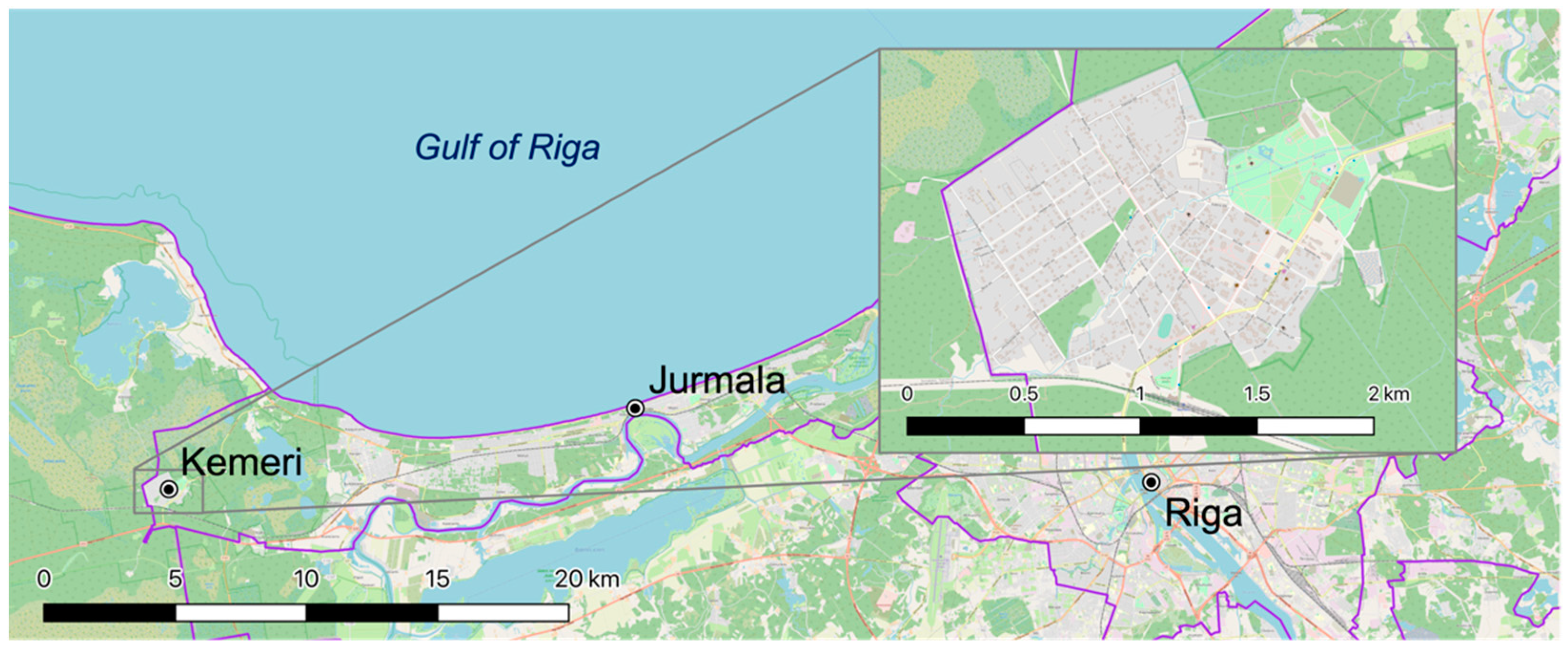
Kemeri is a suburb located within the city of Jurmala, around 40 km west of Latvia’s capital Riga. It consists mainly of low-rise residential buildings and green areas: parks, forests, vacant land plots, etc. The location of the study area is shown in Figure 2.
In general, Jurmala has distinct seasons with wet periods during autumn and spring, dry summers, and cold winters. The study was carried out from October 2021 until May 2022, during which time the second wettest winter since 1924 was recorded [23]. Periods of sub-zero temperatures frequently alternated with stretches of warm weather, which resulted in multiple rapid snowmelt events and a noticeable increase in total wastewater flow.
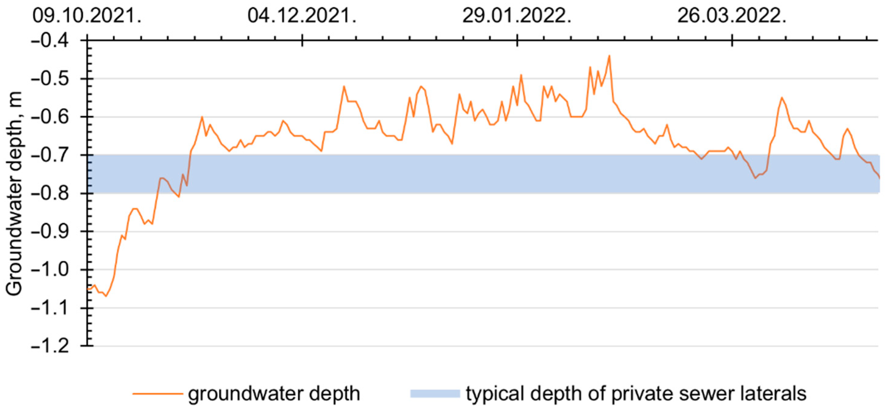
As a result of being surrounded by swamps and marshy areas, the groundwater level (GWL) in Kemeri was noticeably higher than in the rest of the city. Data from depth-to-water maps suggest that the average groundwater depth (GWD) in Kemeri is 0.50 m [24]. The observed changes in GWD during the time of study are depicted in Figure 3.
The total length of the wastewater collection network (WCN) in Kemeri was 14.467 km. The greater part of it (approx. 86%) was built less than 20 years ago using PP pipes (hereinafter, new pipes). The rest of the system (approx. 14%) was constructed in the 1960s and 1970s using mainly reinforced concrete pipes, none of the which have been renovated or replaced (hereinafter, old pipes). During the time of the study, 100% of the publicly-owned sewer mains were constantly below the groundwater table.
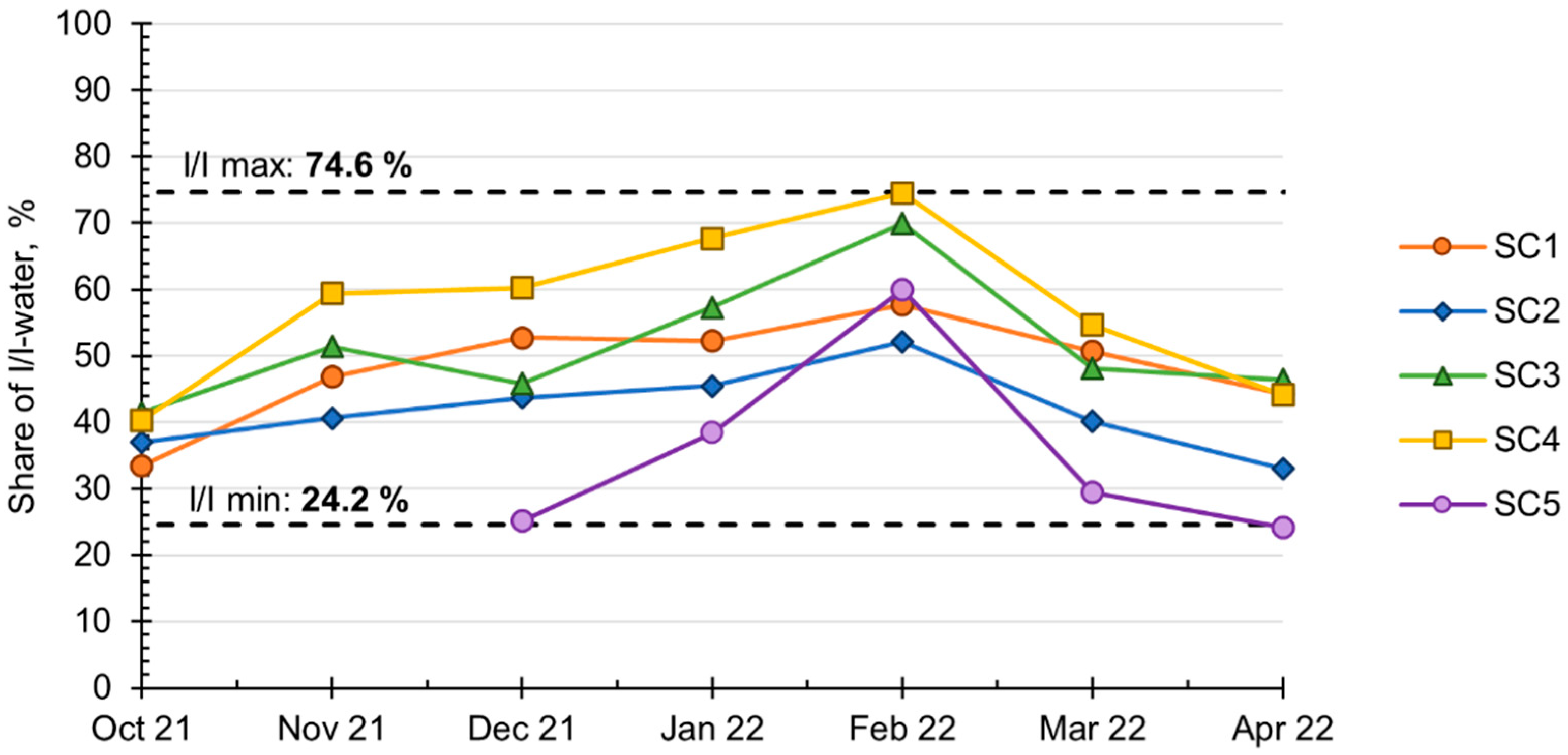
The wastewater collection system was intended to function as a separate system, yet it operates similar to a combined system, conveying both domestic sewerage and surface runoff. During the time of the study, the share of I/I-water on the sub-catchment (SC) level fluctuated between 24.2% and 74.6%. The results were obtained using the water balance method (WBM) [19]. Data regarding domestic wastewater discharge volumes were assumed to match potable water meter readings within the SCs. The results of WBM calculations are summarized in Figure 4.

2.2. Sub-Catchment Description

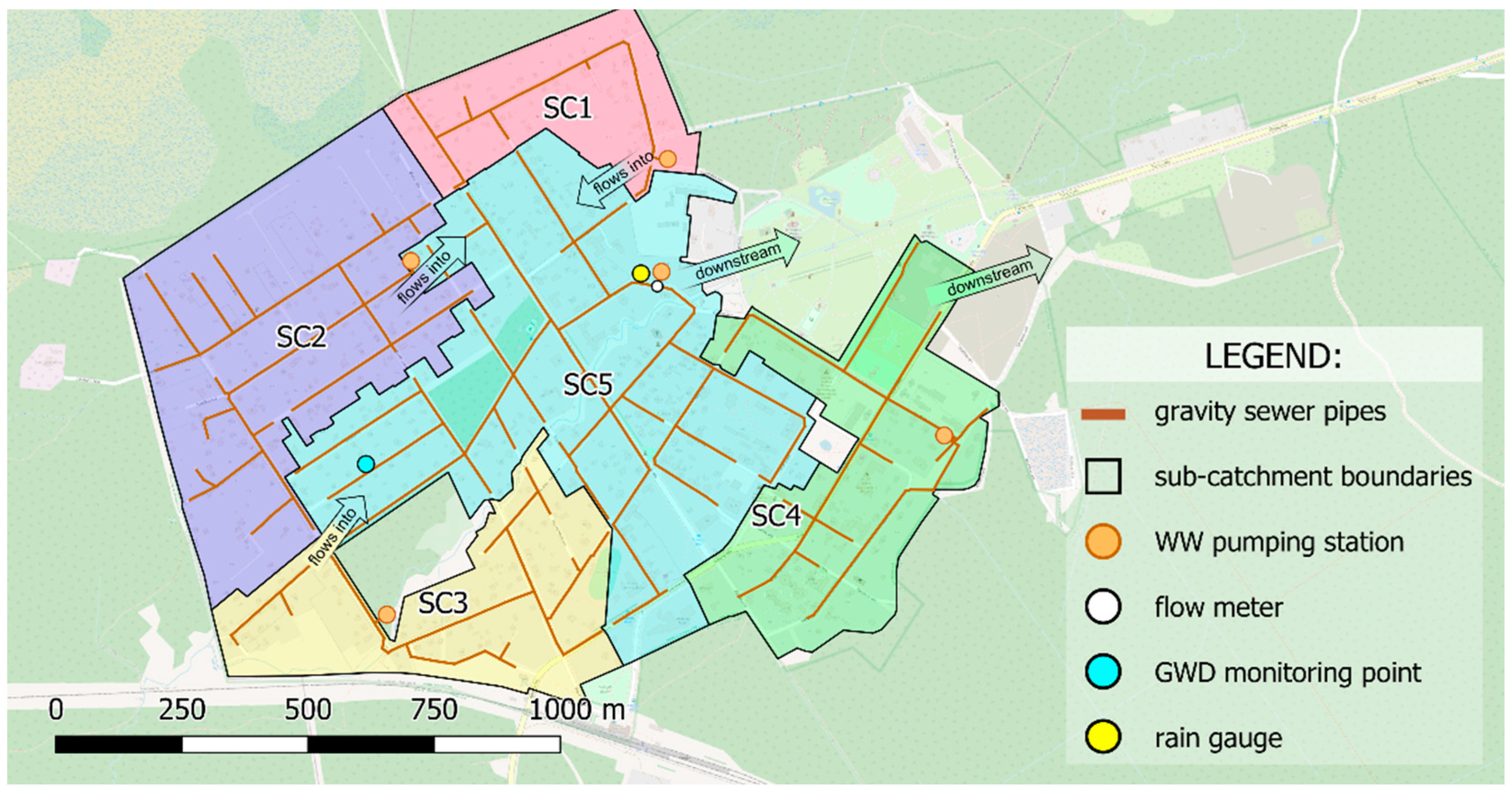
The study area consists of five distinct sub-catchments. SCs 1–3 are situated upstream of the SC5. Wastewater generated by SC4 and SC5 was pumped further downstream via parallel force mains. The system layout, as well as the sub-catchment boundaries and measurement locations, are illustrated in Figure 5.
The characteristics of SCs are summarized in Table 1. During on-site visits, pipes and sewer appurtenances in SCs 1–3 were assessed to be in good condition; CCTV and visual inspections did not reveal any substantial damages to any of the WCN components. In SC4 and SC5, most of the old pipes and manholes were determined to be in bad condition. During the study, no parts of the system were renovated or replaced.
On average, around 63% of properties are connected to the Kemeri WCN. Because of the increasing demands of international environmental policies, the local utility is actively engaged in connecting households to the centralized sewerage system. As a result, the process of connecting to the WCN has been streamlined and excludes watertightness tests that are mandatory for sewer mains maintained by the water services provider. According to data provided by the local utility, the typical depth of the private sewer laterals is 0.70–0.80 m.

2.3. Method to Assess the I/I from Private Sewer Laterals

The impact of private sewer laterals was assessed by grouping the data points based on groundwater depth. Group I (GWD ≤ 0.75 m) indicates where most of the private sewer laterals are partially or entirely submerged in groundwater, and group II (GWD > 0.75 m) indicates where private sewer laterals are above GWL. The results presented in Section 3 regard group I.
For each sub-catchment, a linear regression analysis was applied between GWL and wastewater flow. To test the hypothesis that GWL influences wastewater flow, p-values were calculated. The analysis was carried out using the Descriptive Statistics and Regression modules of the Data Analysis tool in MS Excel v16.60.
For the regression analysis, minimal wastewater flow data during night-time hours (from 00:00 a.m. to 06:00 a.m.) and daily GWL values was used. The night-time window was chosen in accordance with local water supply system data; during the mentioned hours, potable water usage essentially ceased, hence the sewage discharge is minimal. To assess the impacts of both seasonal and temporary GWL changes, data were examined under different weather conditions, including both dry and wet weather events. To record rainfall intensity and daily accumulated precipitation, a Kalyx-RG tipping bucket rain gauge by Campbell Scientific was set up on the PS roof in SC5.
The proposed method acted as the middle ground between system-wide I/I studies and in-depth inspections of individual house drains. While it is not possible to quantify the volume of I/I-water entering the system through faulty house connections using this approach, a comparison among SCs or system segments can be made. It should be noted that the results obtained within a certain SC cannot be extrapolated to other areas without prior consideration of local hydrological conditions and sewerage system attributes. However, considering that the required data are readily available for most utility operators (gathered by the SCADA system or published in open access), an extensive analysis can be carried out relatively quickly. Therefore, the proposed approach has the potential to result in sizable savings in terms of capital and workforce costs.

2.4. Measuring Equipment

To carry out the regression analysis described in Section 2.3, collection of reliable wastewater flow and groundwater level data was essential. GWD data was gathered manually by taking daily measurements in a well within the study area. Wastewater flow was measured using MACE FloPro XCi flow meter equipped with a combined velocity and depth sensor designed for use in partially full pipes. The characteristics of the equipment used during the study are outlined in Table 2; measurement locations can be seen in Figure 5.
The wastewater flow meter uses the velocity–area principle to calculate the flowrate Q. Calculations are done using Formula (1) by taking into account average flow velocity and its cross-sectional area:
Q = vavg × A,
where:
Q is the flowrate, m3/s;
vavg is the average flow velocity, m/s;
A is the flow cross-section, m2.
The flow cross-sectional area A is determined by continuously measuring the flow depth and taking into account the geometrical properties (shape and dimensions) of the conduit. Depth was measured using a single pressure transducer, placed in the bottom part of the pipe slightly offset from the invert. To fine-tune the flow depth readings, an offset value was introduced in the software during the setup process.
The flow velocity was measured using a submerged ultrasonic sensor, which operated based on the Doppler principle. Per the manufacturers recommendations, the sensors were installed facing upstream. The measurement frequency was set to 1 min, however, to smoothen the data series and minimize the impact of instantaneous flow fluctuations, a sliding average with a period of 5 min was used.
It should be noted that continuous data logging was not possible due to various environmental factors encountered during the study. Interruptions in the data series were caused by a build-up of sediment on top of the sensors and excessive humidity within the sewer atmosphere. Therefore, to obtain reliable data for comparative I/I studies, it is crucial to frequently monitor the state of measuring equipment. In total, 13 days with abnormal and erroneous data were excluded from the analysis.
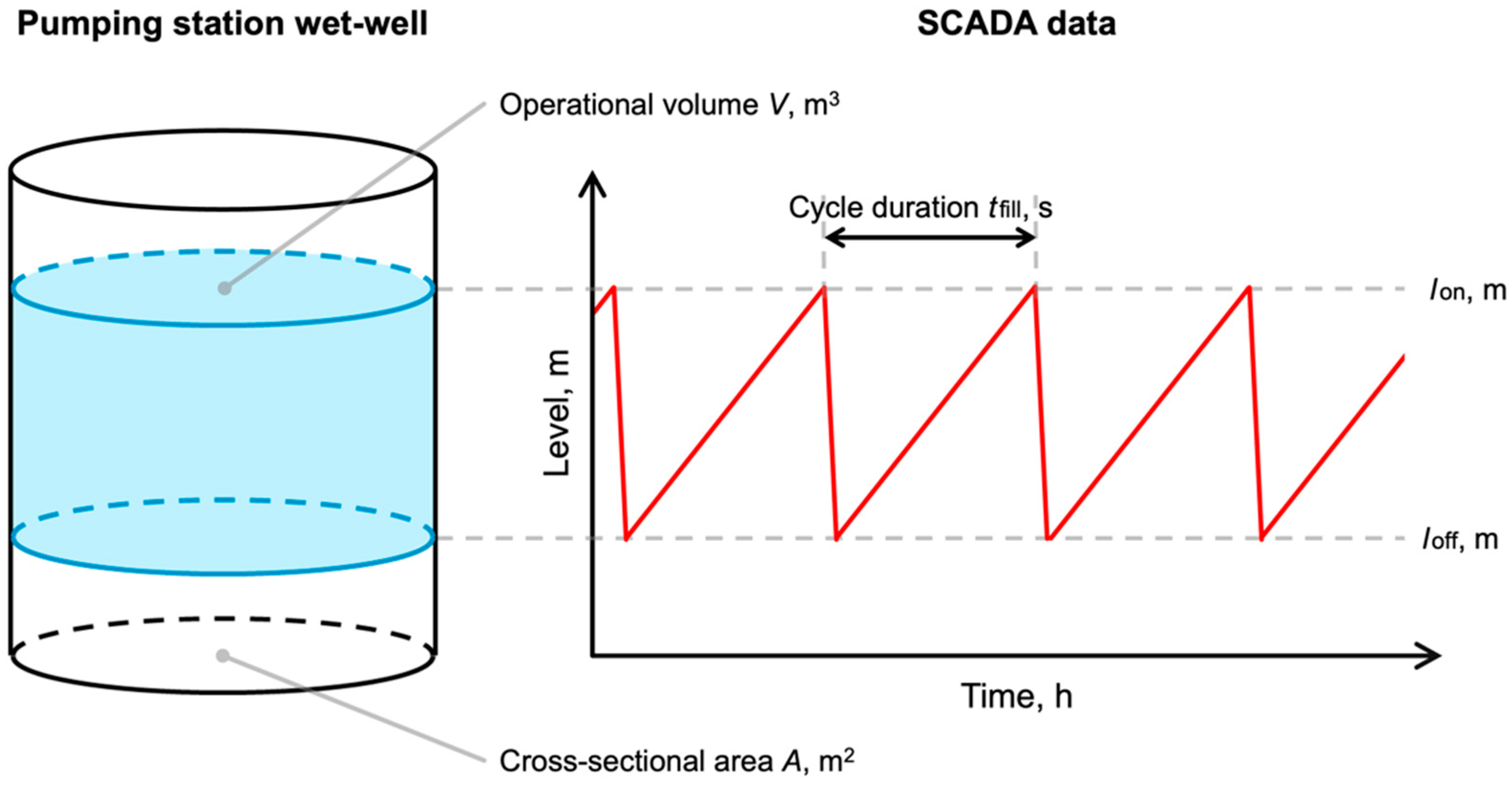
Direct flow measurements were taken at the inlet of the Puskina street PS wet-well. As it has been previously pointed out, the operational limitations of flow measuring equipment make it difficult to obtain accurate data for smaller drainage areas [25]. In the case of upstream sub-catchments in Kemeri, during night-time hours the flow depth did not meet the minimal criteria specified by the sensor manufacturer. Thus, a different approach was used to determine the wastewater flow. Based on data collected by the SCADA system, the average flowrate during the pumping cycle was calculated using the operational volume of the wet-well and the time it takes to fill up the reservoir. The calculations were done using Formula (2):
Qavg = Ares × (lon − loff)/tfill,
where:
Qavg is the flowrate, m3/s;
Ares is the cross-sectional area of the PS wet-well, m2;
lon is the pump start elevation, m;
loff is the pump stop elevation, m;
tfill is the pump cycle duration, s.
Figure 6 illustrates the method used to calculate the average flowrate during pump operation.
It should be noted that calculations made using Formula (2) do not account for the sewage that enters the pumping station during the pump operation. However, in this case, the pump working time greatly exceeds the time it takes to fill up the reservoir, so the impact on the overall result can be deemed negligible. The applicability of Formula (2) in other studies should be evaluated.

3. Results

The main characteristics of WCNs (dimensions, installation depth, land use types, etc.) among selected territories are similar. However, it should be noted that portions of SC3 and SC5 are situated near a small creek with five crossings in total. As a result, these areas are more susceptible to surface water inflow during rapid snowmelt events.
To gauge the influence of local hydrological conditions on the performance of selected WCNs, a linear regression model was created for each of the SCs. The results indicate a distinct negative correlation between GWD and the observed night-time wastewater flows, i.e., if GWL rises, baseflow in the sewer systems increases. The regression analysis results are summarized in Table 3.
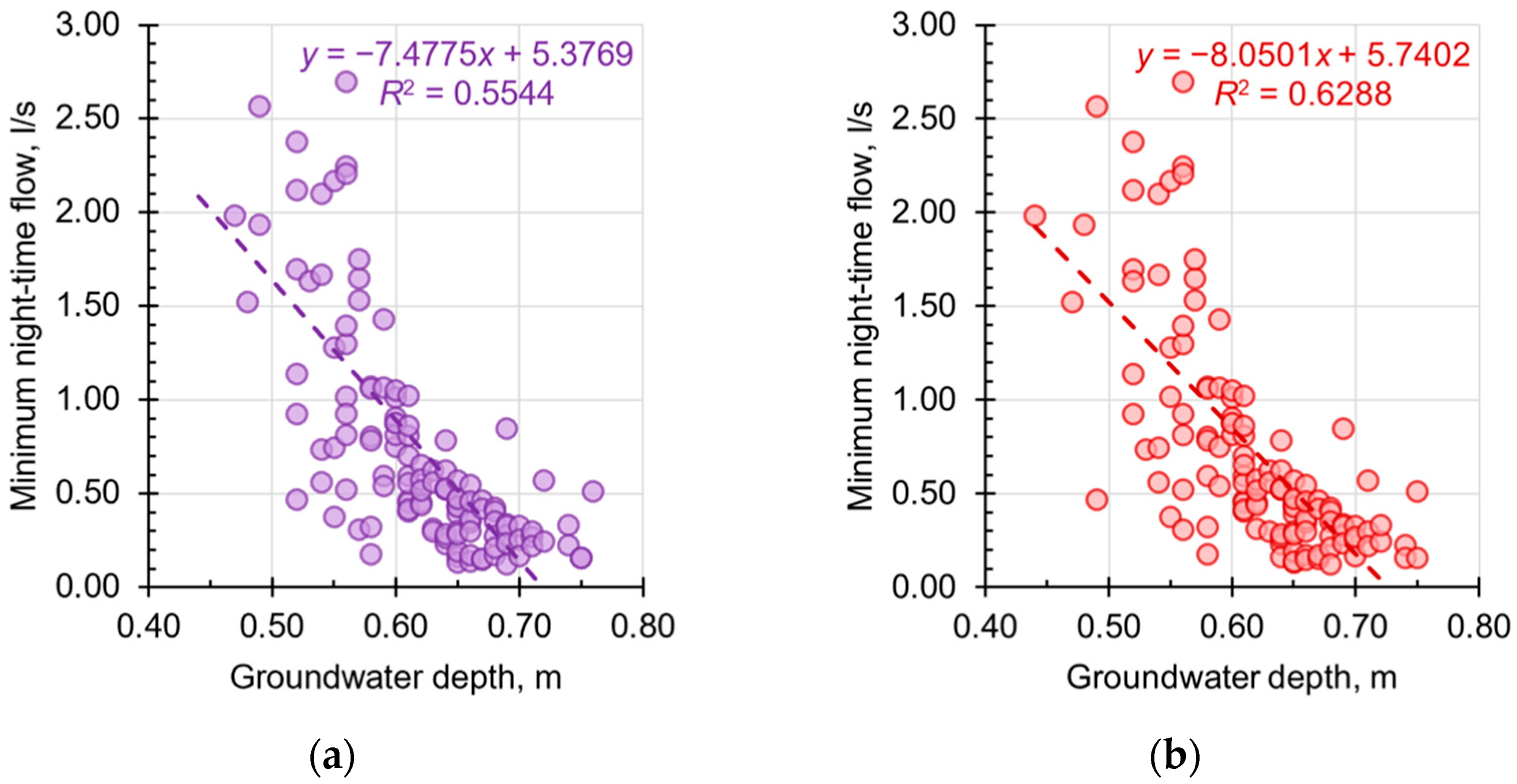
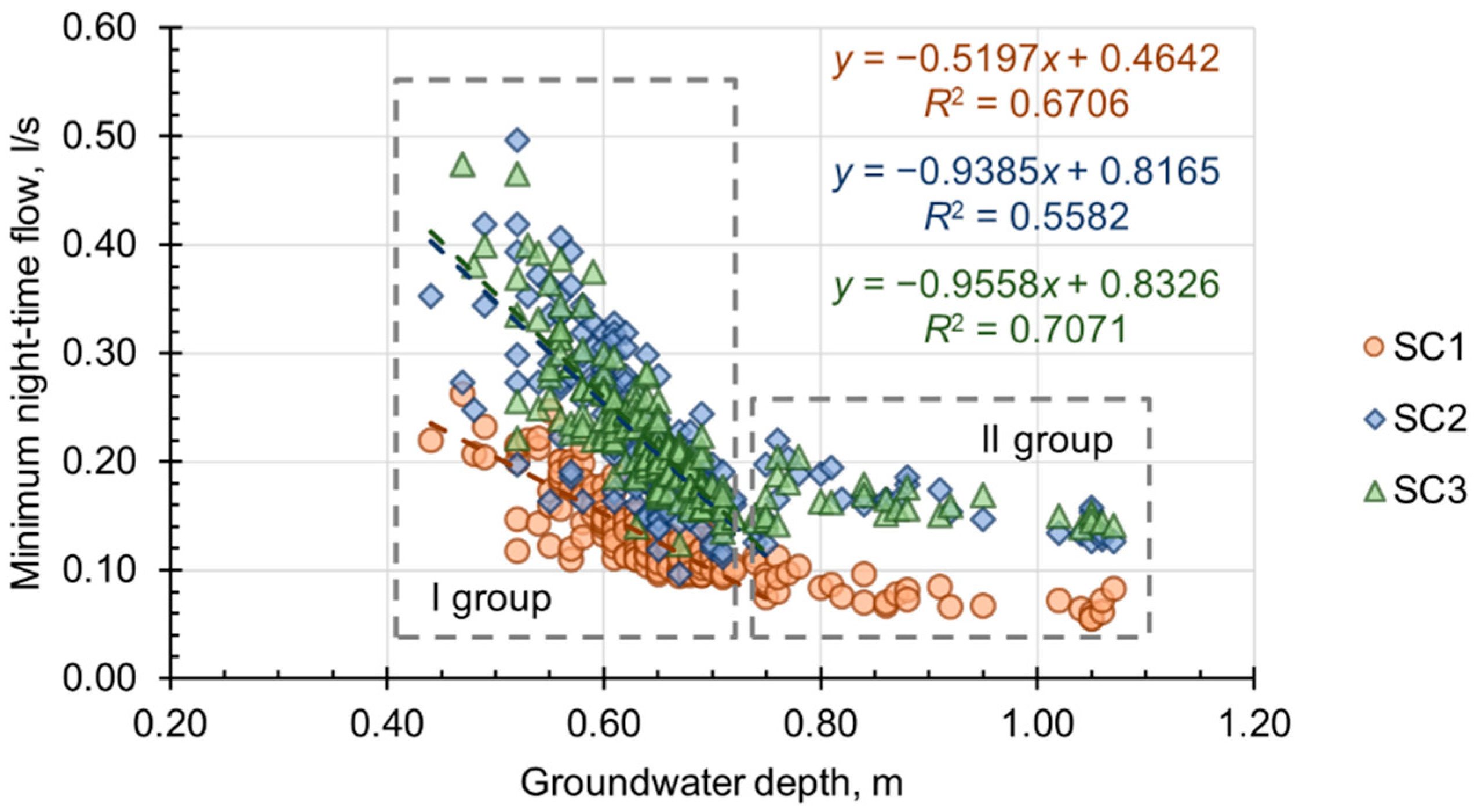
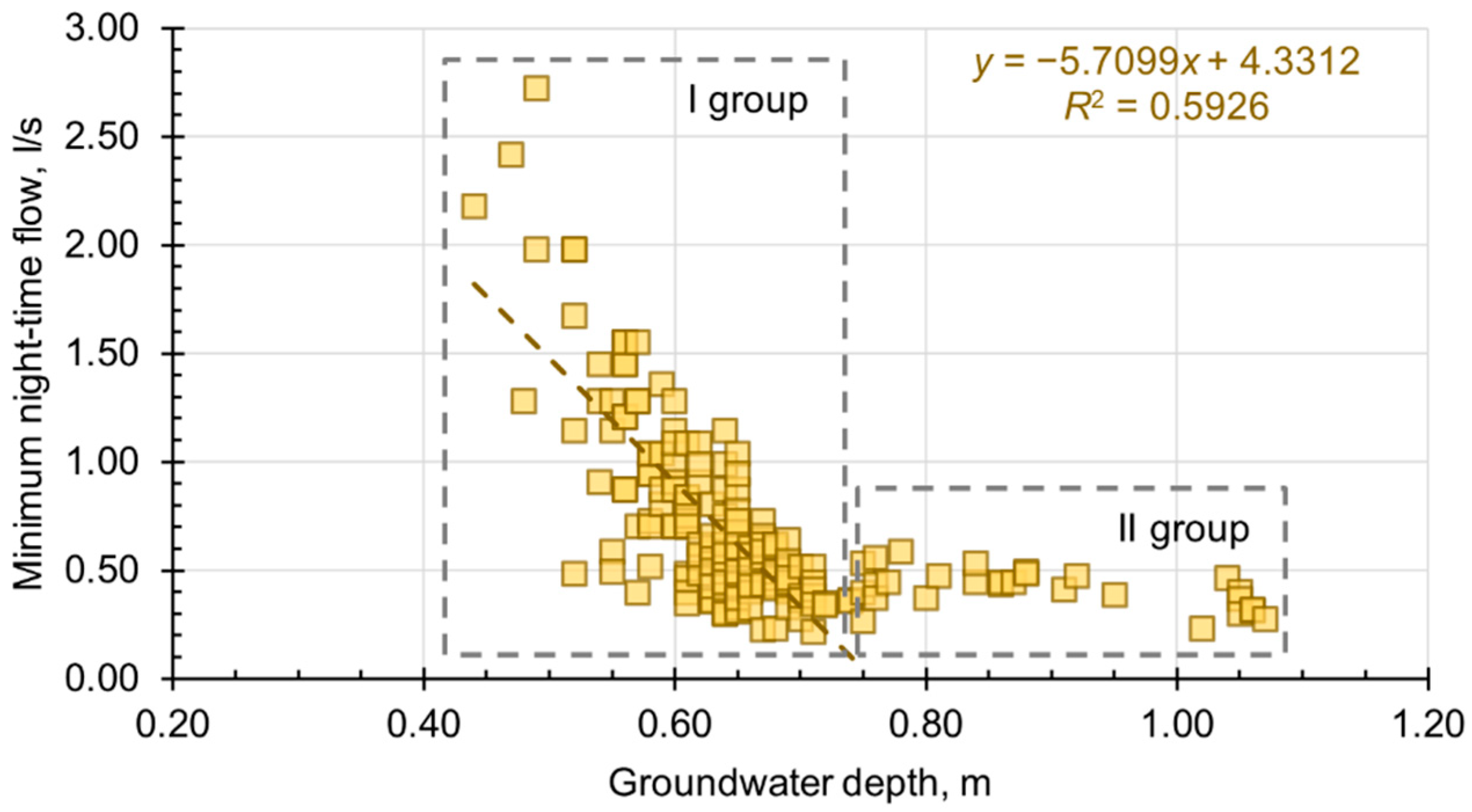
Because, in all cases, the correlation coefficient was R > 0.70 and regression coefficient was R2 > 0.50, it was possible to use the fitted regression equations to predict the wastewater flow values for the new observations of GWD. The calculated p-values (<<0.05) indicate that the observed results are statistically significant thus null hypothesis can be rejected. Based on the results, it can be concluded that GWL variations influence wastewater flows within the study area. Data points, their respective regression lines, and regression equations are shown in Figure 7, Figure 8 and Figure 9.
In the case of SC5, a delay (approx. 1 day) existed between the rise of GWL and an observable increase in wastewater baseflow. This could be explained by the time it takes for sewage to reach the PS from the farthest points of upstream SCs. An alternative regression model was developed considering the time lag; in this case, a stronger correlation was observed.
A similar situation was observed in other SCs. In Figure 8 and Figure 9, the observations form two distinct groups: group I with a definite correlation and group II with no apparent relationship between GWD and wastewater baseflow. For all of the studied SCs, the line of separation between the mentioned groups can be drawn at GWD 0.75 m, which corresponds to the typical installation depth of private sewer laterals.
Data points in group II are relatively stable and can be attributed to damage in the publicly-owned part of the system. The fluctuations in these values can be explained by the inevitable use of potable water and the subsequent generation of domestic wastewater during night-time. Thus, it can be reasonably hypothesized that the main culprit of I/I within the study area is poorly built private sewer laterals and possible local drainage system connections.
In the case of SC4, minimum wastewater flow during night-time hours was 2–5 times greater when compared with SCs with new pipes. This observation can be explained by the fact that the greater part of the network within the mentioned SC was built more than 50 years ago using lower quality materials that, in turn, are more susceptible to corrosion damage.

4. Discussion

Limiting the volume of I/I-water that enters the WCN through defective infrastructure components and faulty connections is one way of increasing the resilience of existing sewerage systems. The presence of excess water is a definite problem within the Kemeri WCN. During the study, the share of I/I-water exceeded 30% in all of the studied SCs. These alarming figures can be attributed to a combination of factors. Old pipes, overdue maintenance of various infrastructure elements, subpar upkeep of private sewer networks, incorrectly routed stormwater sewer appurtenances, and drainage system connections are all likely contributors towards the total I/I volume.
Data compiled by the PUC indicate that the share of I/I-water in Jurmala, during the 2016–2020 period, was between 38.4% and 44.7% [21]. However, during the time of the study, the share of I/I-water on a SC scale fluctuated between 24.2% and 74.6%. Because the main characteristics of the analyzed SCs (potable water use patterns, land use types, WCN parameters, etc.) are similar, it can be concluded that the proposed approach can be used for prioritizing problem areas within the WCN and for narrowing down areas of further interest. This paper presents a simple method for investigating the link between GWL and wastewater flow during night-time hours. Linear regression analysis between the mentioned variables can be a useful tool to identify the potential sources of diluted wastewater. Although numerous methods for locating I/I are available, most of them require extensive use of on-site work or substantial capital investments. Coupled with the groundwater infiltration potential (GWIP) method [26], this can be a productive approach for pinpointing exact problem areas within the WCN. By narrowing down the scope of further investigations, sizable savings in terms of capital and workforce costs can be achieved.
The results show a distinct correlation between GWL and observed sewer system baseflow during periods of high groundwater levels. Similar conclusions on a system-wide scale have been made by other authors [27]. Based on the distribution of the analyzed data points, it can be hypothesized that the source of the problem is located within the privately-owned parts of the sewerage system. GWL during winter and early spring corresponds to the typical installation depth of said components. Private sewer laterals, which are situated above GWL for most of the year but become partially or fully submerged during prolonged periods of wet weather, are susceptible to groundwater infiltration through damaged manholes and pipes.
The volume of infiltrate that originates from house connections is unknown and should, therefore, be the subject of further investigations. The potential use of other quantification techniques, such as distributed temperature sensing (DTS), should be considered. The mentioned approach has previously been successfully applied in catchment areas similar to Kemeri [28,29]. Factors such as pipe age, piping material, number of manholes were not considered during the current research project; therefore, further studies should implement principal component analysis (PCA) as a means of ranking the influence of these factors.
The results obtained during the study represent the situation in Kemeri WCN and must not be extrapolated to other areas without prior consideration of local hydrological conditions and sewerage system attributes. Uncertainty in the obtained results can be caused by the use of SCADA data for average flowrate calculations. However, the choice regarding the data acquisition method is not critical, considering the objective of the study is to determine the dominant source of I/I rather than to work out the exact volume of I/I-water. A similar notion has been previously expressed by other authors [11]. Another point to consider when evaluating the results is the spatial relation of the GWL monitoring point and the studied SCs. Based on the relatively flat terrain and the available information regarding soil composition within the study area, the hydrological properties (consequently GWL) were assumed to remain constant throughout the SCs. To gain an outlook on I/I processes within other SCs in Jurmala, expansion of the GWL monitoring network is necessary.
Considering that sewer system overflows did not occur during the study period, it can be said that the presence of excess water in Kemeri WCN has financial implications. The problem could be partially solved by implementing water tightness requirements for private sewer laterals into national legislation, and enforcing them on a municipal level through comprehensive testing of home connections before acceptance into operation. The amount of excess water that can be eliminated through comprehensive testing of new connections should be examined for each SC separately. Another point of contention is the current state of existing house connections, which are outside the maintenance boundaries set by the local utility and are thus not included in the WCN renovation plans.
In the case of Kemeri, the potential remediation strategies for minimizing I/I should include upgrades to the existing drainage systems. As it has been previously pointed out [8], the elimination of I/I will inevitably elevate the groundwater table, which in turn will result in flooding of depressed territories. The positive impacts of I/I (additional flushing, decrease in odors, and corrosion), as well as cost of procurements, should be taken into account when setting I/I reduction goals.

5. Conclusions

In the presented study, the use of linear regression analysis between GWL and wastewater baseflow to predict the likely sources of excess water was considered and analyzed in multiple SCs in Jurmala, Latvia. For this purpose, continuous logging of wastewater flow and daily measurements of GWL were carried out.
The results show a distinct correlation between GWD and observed night-time wastewater flows during periods of high groundwater tables. Based on the observation that the increase of wastewater baseflow occurred when private sewer laterals were partially or entirely underwater, it is reasonable to hypothesize that the main sources of I/I were located within the privately-owned parts of the sewerage system. However, to accurately quantify the volume of excess water originating from house connections, the use of more sophisticated methods (such as DTS) should be considered.
This method has shown robustness even in relatively small drainage areas. Coupled with the groundwater infiltration potential (GWIP) method, this can be a productive approach for pinpointing exact problem areas within the WCN and narrowing down the scope of further investigations.
The results of this study highlight the impact of poorly built private sewer laterals on the overall resilience of a centralized sewerage system. I/I investigation is a demanding and time-consuming endeavor, but can provide invaluable insights into the current state of the system. The results obtained during such activities can aid system operators and decision-makers in setting the order of renovations. The development of cost-effective procurements is a crucial part of sewer infrastructure asset management, as well as sustainable urban water management.

Author Contributions

conceptualization, G.D. and S.D.; methodology, G.D.; investigation, G.D.; writing—original draft preparation, G.D.; writing—review and editing, S.D. and J.R.; visualization, G.D.; supervision, S.D. and J.R. All authors have read and agreed to the published version of the manuscript.

Funding

The research was funded by the Riga Technical University under grant no. ZM-2021/9 and was supported by the European Union (European Regional Development Fund) Interreg Baltic Sea Region Program under grant no. #R093.

Institutional Review Board Statement

Not applicable.

Informed Consent Statement

Not applicable.

Data Availability Statement

Not applicable.

Acknowledgments

The authors wish to thank Jurmalas udens Ltd. for willingly sharing information and providing access to their data and facilities. The authors also thank Riga Technical University for funding the study.

Conflicts of Interest

The authors declare no conflict of interest.

References

  1. Infrastructure to 2030 (Volume 2): Mapping Policy for Electricity, Water and Transport. Available online: https://www.oecd.org/futures/infrastructureto2030/40953164.pdf (accessed on 3 August 2022).
  2. Semadeni-Davies, A.; Hernebring, C.; Svensson, G.; Gustafsson, L.-G. The Impacts of Climate Change and Urbanisation on Drainage in Helsingborg, Sweden: Combined Sewer System. J. Hydrol. 2008, 350, 100–113. [Google Scholar] [CrossRef]
  3. Ellis, J.B. (Ed.) Assessing Infiltration and Exfiltration on the Performance of Urban Sewer Systems (APUSS); IWA Publishing: London, UK, 2010; ISBN 978-1-84339-149-4. [Google Scholar]
  4. Thorndahl, S.; Balling, J.D.; Larsen, U.B.B. Analysis and Integrated Modelling of Groundwater Infiltration to Sewer Networks: Integrated Modelling of Groundwater Infiltration to Sewer Networks. Hydrol. Process. 2016, 30, 3228–3238. [Google Scholar] [CrossRef]
  5. Rödel, S.; Günthert, F.W.; Brüggemann, T. Investigating the Impacts of Extraneous Water on Wastewater Treatment Plants. Water Sci. Technol. 2017, 75, 847–855. [Google Scholar] [CrossRef] [PubMed]
  6. Weiß, G.; Brombach, H.; Haller, B. Infiltration and Inflow in Combined Sewer Systems: Long-Term Analysis. Water Sci. Technol. 2002, 45, 11–19. [Google Scholar] [CrossRef] [PubMed]
  7. Sola, K.J.; Bjerkholt, J.T.; Lindholm, O.G.; Ratnaweera, H. Analysing Consequences of Infiltration and Inflow Water (I/I-Water) Using Cost-Benefit Analyses. Water Sci. Technol. 2020, 82, 1312–1326. [Google Scholar] [CrossRef] [PubMed]
  8. Gustafsson, L.-G. Alternative Drainage Schemes for Reduction of Inflow/Infiltration-Prediction and Follow-Up of Effects with the Aid of an Integrated Sewer/Aquifer Model. In Proceedings of the 1st International Conference on Urban Drainage, Internet, 21 September 2000; p. 17. [Google Scholar]
  9. Marleni, N.; Gray, S.; Sharma, A.; Burn, S.; Muttil, N. Impact of Water Management Practice Scenarios on Wastewater Flow and Contaminant Concentration. J. Environ. Manag. 2015, 151, 461–471. [Google Scholar] [CrossRef] [PubMed]
  10. Saletti, A.O.; Rosén, L.; Lindhe, A. Framework for Risk-Based Decision Support on Infiltration and Inflow to Wastewater Sewer Systems. Water 2021, 13, 2320. [Google Scholar] [CrossRef]
  11. Bénédittis, J.; Bertrand-Krajewski, J.-L. Infiltration in Sewer Systems: Comparison of Measurement Methods. Water Sci. Technol. 2005, 52, 219–227. [Google Scholar] [CrossRef] [PubMed]
  12. Beheshti, M.; Sægrov, S.; Ugarelli, R. Infiltration/Inflow Assessment and Detection in Urban Sewer System. Vann 2015, 1, 24–34. [Google Scholar]
  13. Matos, R.; International Water Association (Eds.) Performance Indicators for Wastewater Services; Manual of best practice; IWA Publishing: London, UK, 2003; ISBN 978-1-900222-90-7. [Google Scholar]
  14. Kracht, O.; Gujer, W. Quantification of Infiltration into Sewers Based on Time Series of Pollutant Loads. Water Sci. Technol. 2005, 52, 209–218. [Google Scholar] [CrossRef] [PubMed]
  15. Bareš, V.; Krejčí, P.; Stránský, D.; Sýkora, P. Long-Term Monitoring of Infiltration/Inflow Based on Diurnal Variation of Pollutant Mass Flux. In Proceedings of the 11th International Conference on Urban Drainage, Edinburgh, UK, 31 August–5 September 2008; p. 10. [Google Scholar]
  16. Dirckx, G.; Bixio, D.; Thoeye, C.; De Gueldre, G.; Van De Steene, B. Dilution of Sewage in Flanders Mapped with Mathematical and Tracer Methods. Urban Water J. 2009, 6, 81–92. [Google Scholar] [CrossRef]
  17. Prigiobbe, V.; Giulianelli, M. Quantification of Sewer System Infiltration Using Δ18O Hydrograph Separation. Water Sci. Technol. 2009, 60, 727–735. [Google Scholar] [CrossRef] [PubMed]
  18. De Ville, N.; Le, H.M.; Schmidt, L.; Verbanck, M.A. Data-Mining Analysis of in-Sewer Infiltration Patterns: Seasonal Characteristics of Clear Water Seepage into Brussels Main Sewers. Urban Water J. 2017, 14, 1090–1096. [Google Scholar] [CrossRef]
  19. Sola, K.J.; Bjerkholt, J.T.; Lindholm, O.G.; Ratnaweera, H. Infiltration and Inflow (I/I) to Wastewater Systems in Norway, Sweden, Denmark, and Finland. Water 2018, 10, 1696. [Google Scholar] [CrossRef]
  20. Kaczor, G.; Agnieszka, C. Analysis of the Proportion of Incidental Water in Annual Wastewater Inflows to a Selected Treatment Plant during a 15-Year Observation Period. J. Ecol. Eng. 2021, 22, 204–211. [Google Scholar] [CrossRef]
  21. Ūdenssaimniecības Nozares Rādītāji. Available online: https://www.sprk.gov.lv/content/nozares-raditaji-0 (accessed on 3 August 2022). (In Latvian)
  22. Relation: Jūrmala (13048687)-OpenStreetMap. Available online: https://www.openstreetmap.org/relation/13048687 (accessed on 24 August 2022).
  23. Ziema, 2021. Available online: https://klimats.meteo.lv/laika_apstaklu_raksturojums/2022/ziema/ (accessed on 3 August 2022). (In Latvian).
  24. Depth-to-Water Kartēšanas Dati. Available online: http://www.silava.lv/produkti/Kartografiskie-materiali.aspx (accessed on 3 August 2022). (In Latvian).
  25. Sola, K.J.; Bjerkholt, J.; Lindholm, O.; Ratnaweera, H. What Effect Does Rehabilitation of Wastewater Pipelines Have on the Share of Infiltration and Inflow Water (I/I-Water)? Water 2021, 13, 1934. [Google Scholar] [CrossRef]
  26. Dirckx, G.; Van Daele, S.; Hellinck, N. Groundwater Infiltration Potential (GWIP) as an Aid to Determining the Cause of Dilution of Waste Water. J. Hydrol. 2016, 542, 474–486. [Google Scholar] [CrossRef]
  27. Fung, A.; Babcock, R. A Flow-Calibrated Method to Project Groundwater Infiltration into Coastal Sewers Affected by Sea Level Rise. Water 2020, 12, 1934. [Google Scholar] [CrossRef]
  28. Beheshti, M.; Sægrov, S. Quantification Assessment of Extraneous Water Infiltration and Inflow by Analysis of the Thermal Behavior of the Sewer Network. Water 2018, 10, 1070. [Google Scholar] [CrossRef]
  29. Beheshti, M.; Sægrov, S. Detection of Extraneous Water Ingress into the Sewer System Using Tandem Methods—A Case Study in Trondheim City. Water Sci. Technol. 2019, 79, 231–239. [Google Scholar] [CrossRef] [PubMed]
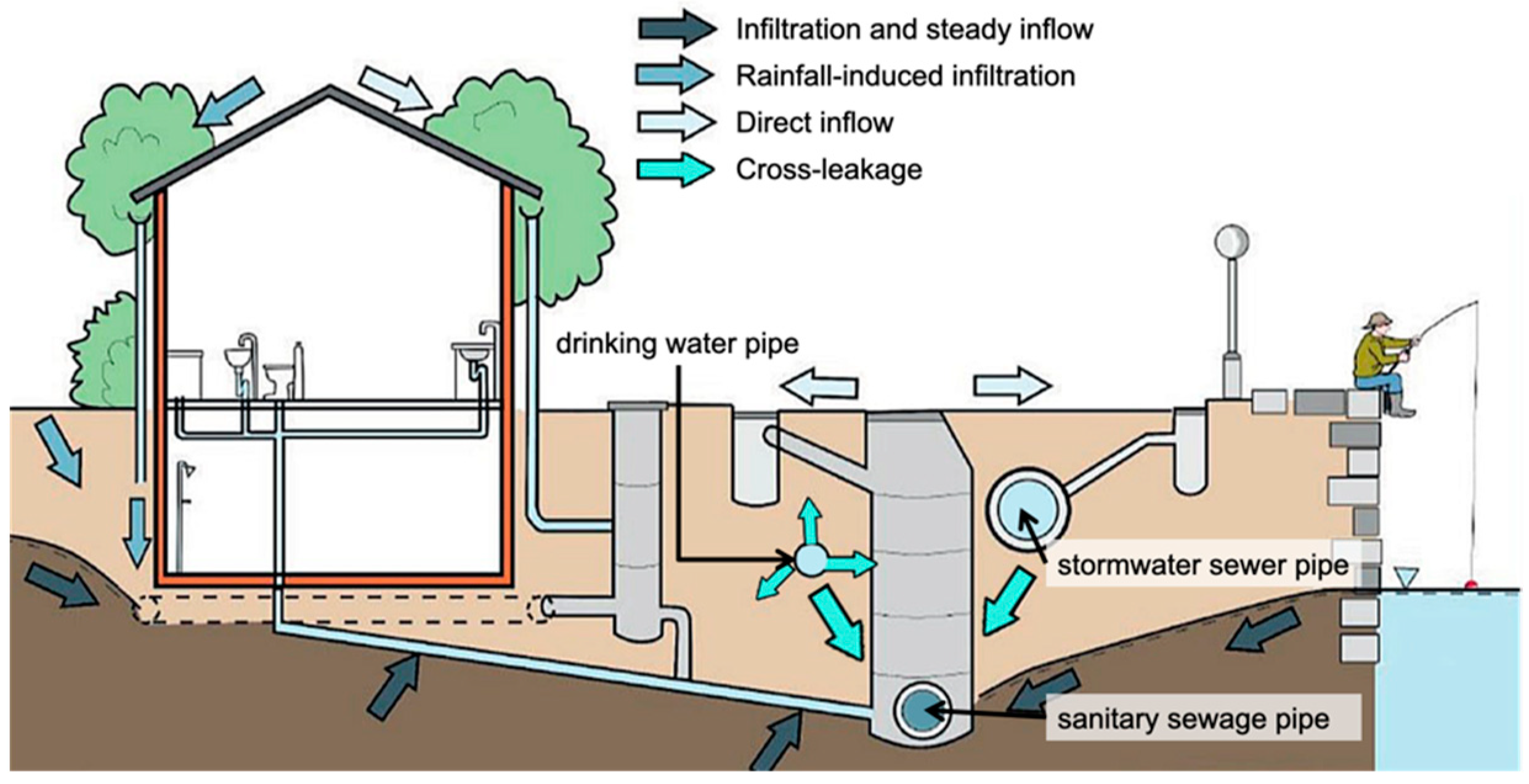
Figure 1. Possible sources of infiltration and inflow (modified from [10]).
Water 14 02870 g001
Figure 2. Location of the study area (basemap taken from [22]).
Water 14 02870 g002
Figure 3. GWD variation during the study period.
Water 14 02870 g003
Figure 4. Results of WBM during the study period.
Water 14 02870 g004
Figure 5. Sub-catchment boundaries and WCS layout in Kemeri.
Water 14 02870 g005
Figure 6. Schematic illustrating the average flowrate calculation process used in the study.
Water 14 02870 g006
Figure 7. Scatter plots with trendlines and regression equations for SC5: (a) w/o offset; (b) w/offset.
Water 14 02870 g007
Figure 8. Scatter plots with trendlines and regression equations for SCs 1–3.
Water 14 02870 g008
Figure 9. Scatter plot with trendline and regression equation for SC4.
Water 14 02870 g009
Table 1. Characteristics of the sub-catchments.
Sub-CatchmentNetwork
Length, m
Share of Old * Pipes, %Average
Depth, m
Connected Households, %
SC11120.302.4785
SC23144.802.4860
SC32067.102.7264
SC42486.7822.7846
SC5 **5648.2312.6058
* Within the context of this publication pipes built before 2000 are called “old”. ** Data do not include upstream territories.
Table 2. Characteristics of the measuring equipment used during the study.
Measuring DeviceParameter MeasuredMeasurement AccuracyMeasurement Frequency
MACE FloPro XCiFlow velocity±1% up to 3.0 m/sEvery minute
Flow depth0.2–1.0% of full scale
Campbell ScientificRainfall depth± 0.2 mmEvery 5 min
Kalyx-RGRainfall intensity>98% up to 20 mm/h
Measuring RodGroundwater level±0.01 mDaily
Table 3. The results of the regression analysis between wastewater flow and GWL.
ParameterSC1SC2SC3SC4SC5
w/o offsetw/offset
Correlation coeff. R0.81890.74710.84100.76980.77460.7930
Regression coeff. R20.67060.55820.70710.59260.55440.6288
y-intercept0.46420.81650.83264.33125.37695.7402
Slope−0.5197−0.9385−0.9558−5.7009−7.4775−8.0501
p-value1.33 × 10−423.74 × 10−321.15 × 10−462.28 × 10−352.48 × 10−235.01 × 10⁻²⁸
Count171173173174125124
Publisher’s Note: MDPI stays neutral with regard to jurisdictional claims in published maps and institutional affiliations.