Article

Latitudinal and Altitudinal Gradients of Riverine Landscapes in Andean Rivers

1
Departamento de Sistemas Acuáticos, Facultad de Ciencias Ambientales, Universidad de Concepción, Concepción 4070386, Chile
2
Centro de Ciencias Ambientales EULA-Chile, Universidad de Concepción, Concepción 4070386, Chile
3
Departamento de Ingeniería Ambiental, Facultad de Ciencias Ambientales, Universidad de Concepción, Concepción 4070386, Chile
4
Departamento de Ingeniería Civil, Facultad de Ingeniería, Universidad de Concepción, Concepción 4070386, Chile
5
Instituto de Ciencias Marinas y Limnológicas, Facultad de Ciencias, Universidad Austral de Chile, Valdivia 5090000, Chile
6
Facultad de Ciencias, Universidad Católica de la Santísima Concepción, Concepción 4030000, Chile
*
Author to whom correspondence should be addressed.
Water 2022, 14(17), 2614; https://doi.org/10.3390/w14172614
Submission received: 26 July 2022 / Revised: 22 August 2022 / Accepted: 23 August 2022 / Published: 25 August 2022
(This article belongs to the Topic Remote Sensing in Water Resources Management Models)

Abstract

:
Exact knowledge of the physical structures of different river sections that govern their ecological structure and function is essential for the efficient conservation and management of riverine ecosystems. Eleven Andean river basins (Maipo, Rapel, Mataquito, Maule, Itata, Biobío, Toltén, Valdivia, Bueno and Puelo) comprise large scale latitudinal and altitudinal gradients and accommodate 71% of the Chilean population that strongly depend on their ecosystem services. Here, based on 16 hydrogeomorphic variables (on basin, valley and channel scales), we assessed the riverine landscapes (Functional Process Zones; FPZs) of these river basins using a top-down multivariate statistical approach. Two steep valley and downstream slope FPZs, three sinuous FPZs and two braided FPZs emerged in 8906 river sections. The proportion of the occurrence of FPZs was characterised by a clear latitudinal pattern which is strongly related to the proportions of each river basin within the large morphostructural units of Chile. As such, the proportion of each river basin within the Andes Cordillera, Central Valley and Coastal Cordillera is a strong driver of the fluvial geomorphology and, thus, of the FPZs’ arrangement in each river network. FPZ classification captured geomorphic diversity that coincided with the latitudinal and altitudinal gradients of Chilean Andean river basins strongly related to the hydrological characteristics of the assessed river basins and large scale spatial distribution of fish fauna endemism. As such, the identified large geomorphic units (FPZs) that are strongly tied up with hydrology and ecology hierarchies of riverine landscape provide robust operational tools that can be instrumental for river ecosystem monitoring and management at a basin scale.

1. Introduction

Rivers are complex adaptive ecosystems that respond to natural and anthropogenic disturbances in complex ways [1]. Understanding the ability of rivers to respond to disturbances requires a paradigm where they are viewed as hierarchical, dynamic and multidimensional ecosystems [2]. Conceptual frameworks proposed to understand river ecosystems identify geomorphology, hydrology and ecology as important subsystems or hierarchies that allow river issues to be identified and studied at appropriate scales [3,4]. In the geomorphology hierarchy, the river basin is at the highest level of organisation; with a wide spatial extent that is shaped by long-term geological and climatological processes, they are thus relatively resistant to change. Nested within the river basin at the next level of organisation or scale are Functional Process Zones (FPZs). These are large sections of rivers with relatively uniform geological histories, and channel morphologies controlled by similar discharge and sediment regimes [5]. FPZs contain common structural and functional units that promote similar functional ecological organisations [2,6,7]. The geomorphic hierarchy continues down to the reach, site and microhabitat level [3].
In the last two decades, the study and management of river systems has had a notable shift from a reach or site-based focus to more holistic larger landscape or river basin-scale focus [8]. This shift was, among others, a result of increasing recognition that reach/site-based approaches to the study of rivers often failed to address problems that contribute to longer-term declines in the structure and function of rivers at the river basin scale [2,9]. Increasingly, river research focuses on the structure and processes occurring within FPZs as the most appropriate scale for understanding river ecosystems and their response to disturbances [7,10,11]. At this level of river hierarchy, complex biological responses can be disentangled in order to understand which are the key variables that should be managed to maintain river resilience [12]. For example, ref. [10] showed how study at the FPZ scale allows one to disentangle the complex responses of macroinvertebrate assemblages to flow regulation due to dam operation. The type and position of the FPZ within the river network were the primary drivers of macroinvertebrate responses to flow regulation. Indeed, recognition of FPZs of different complexities within river networks is instrumental for comparisons within and among different river basins in order to unravel the complex ecological responses to changes in hydrology and other natural or anthropogenic disturbances.
The Chilean Andean rivers between 32° and 41° S hold a distinctive spatial distribution, running from ˜3000 m.a.s.l. in the Andes Cordillera to the Pacific Ocean, from East to West, with a parallel distribution from North to South. Furthermore, these basins remained isolated for more than 10,000 years [13]. The Chilean economy and social wellbeing depend strongly on these rivers as they provide water for human consumption, irrigation, hydropower, mining, industries and recreation as well as dilution of domestic and industrial wastewaters. Furthermore, accelerated expansion of the multipurpose use of these rivers has not been accompanied by an increase in the generation of knowledge about their ecosystems’ functioning and resilience [14]. As a consequence, increasing anthropogenic pressures threaten the ability of these rivers to continue the provision of a diverse range of ecosystem services that are highly valued by the society. Eleven Andean river basins located between 32° and 41° S comprise natural and anthropogenic gradients. From North to South, the Maipo, Rapel, Mataquito, Maule, Itata and Biobío rivers are described as rivers with discharge dominated by snowmelt and torrential flows, whereas more southern Toltén, Valdivia, Bueno and Puelo rivers are characterised by discharge regulation due the presence of large headwater lakes or lake chains [15]. Furthermore, a gradient of anthropogenic interventions in these river basins runs between a high level of alterations mainly due to network fragmentation and pollution (Maipo, Rapel, Biobío and Maule rivers), through medium alteration (Mataquito and Itata rivers), to less altered and still non-fragmented large river networks (Imperial, Toltén, Valdivia, Bueno and Puelo rivers).
Different classifications based on characteristics such as hydrological regime, slope or bed sediments have been proposed for Chilean rivers; see [15,16,17,18,19] for examples. Furthermore, ecological classifications based on fish composition related to the hydrological characteristics of the river basin [20] as well as eco-hydrological classifications have been suggested [21]. These classifications, however, have generally considered the hydrological regime as the main factor that determines the structure of the river ecosystem.
To date, management actions for Chilean rivers have been relatively ineffective because the scale of the issues and their hierarchical influence are not well understood or considered [14]. Assessment of specific characteristics and the spatial arrangement of functional process zones (FPZs) may provide an appropriate framework to monitor and manage resilience in riverine ecosystems. In this study, we used an approach based on Geographic Information System (GIS) tools to characterise riverine landscapes and classify FPZs of eleven Chilean Andean river basins located between 32° and 41° S. We expected that FPZ classification would capture the main geomorphic (dis)similarities at the latitudinal and altitudinal gradients of the eleven river basins and that it would relate to the hydrological characteristics previously described for these river basins.

2. Materials and Methods

2.1. Study Area

Eleven river basins located in central-southern Chile between latitudes 32°55′ and 42°09′ S, and longitudes 69°48′ and 72°22′ W were considered in this study (Figure 1). The human population of this area is about 12,316,144 inhabitants (71% of the total population of Chile) [22] and is concentrated in a few big cities located in the Central Valley and coastal plains. Table 1 summarizes the principal characteristics of the studied river basins. In the northern part of the study area, between the Maipo and Biobío River basins, the climate is dominated by the Pacific anticyclone [23,24]. According to the Köppen–Geiger climate classification [25], the predominant climate type is a warm-summer Mediterranean climate (Csb). In the southern part of the study area, between the Imperial and Puelo River basins, the climate is dominated by the southern westerlies [23,24] and is a temperate oceanic climate (Cfb) according to the Köppen–Geiger climate classification [25]. The Biobío and Imperial River basins are located in a climatic transition area with a mixed influence of the southeast Pacific anticyclone and the westerlies [23,24,26]. The climate variability of the study area is influenced by oscillations characterised by different periodicity such as the El Niño-Southern Oscillation [27], the Pacific Decadal Oscillation [28] and the Antarctic Oscillation [24,29]. Approximately 30% of the winter storms are warm winter rainstorms caused by atmospheric rivers [30].
The region of the studied river basins is composed of a number of morphostructural units from East to West: Andes Cordillera, Central Valley and Coastal Cordillera [31]. The Andes Cordillera is a chain of high mountains with a strong relief and steep slopes that in its western part of the Chilean territory mostly comprises Oligocene–Miocene continental volcanoclastic rocks, intruded by Miocene–Pliocene granitoid [13]. The Central Valley is a geological depression with an approximately 70-km-wide plain formed between the Andes and the coastal range with a Mesozoic to Quaternary sedimentary infill [13,31]. The Chilean Coastal Cordillera consists of low and topographically smooth mountains composed predominantly of Late Palaeozoic and Mesozoic igneous rocks, with paired belts of Palaeozoic metamorphic rocks cropping out south of 34° S.
According to the soil taxonomy classification system, most of the study area is covered by six orders, namely Alfisols, Entisols, Inceptisols, Mollisols, Ultisols and Vertisols, as well as Andisol and Histosol series [32]. The study area includes most of the cultivated and productive land in Chile, with the majority of farms (72%) and forest plantations (54%) in the country [32]. The rainfall regime, soil properties, high slopes and land uses make the study area particularly vulnerable to erosion processes [32]. During the irrigation season between October and April, the river basins between the Maipo and Biobío rivers experience water extractions that limit river flow to the minimum allowed environmental flows (10% of the average monthly discharge).
The rivers within the studied basins flow predominantly from East to West and are characterised by a total length between 200 and 400 km, Strahler’s orders up to eight, and annual mean discharges at the mouth between 100 and 1000 m3/s (Table 1). All the studied rivers flow from the Andes through the Central Valley to the Pacific Ocean and are characterised by river longitudinal slopes in the Andes between 5 and 10% [33,34]. Most of the studied river networks are free-flowing, with the exception of the Rapel, Maule and Biobío rivers that accommodate large reservoirs for hydropower production and irrigation. Consistently, these are the most fragmented river networks [35] (Table 1). The study area accommodates 91 of the 148 existing hydropower plants in Chile, with a total power of 5.05 GW, i.e., 76% of the national installed hydropower. Furthermore, 30 new hydropower plants with a total potential of 0.65 GW are under environmental evaluation or construction in the study area [36].

2.2. Riverine Landscape Characterisation

The characterisation of riverine landscapes in order to identify groups of river reaches with similar hydrogeomorphic character (FPZs) was based on 16 hydrogeomorphic variables [37,38]. First, the river networks of the eleven river basins were digitalized using Google Earth Pro 7.3 satellite images. Subsequently, the river network of each river basin was segmented into sections between 1.5 and 3 km long. The lengths of each section were defined based on changes in valley or channel widths and confinement. In each of these sections, data were extracted and 16 hydrogeomorphic variables were calculated (Table 2). Each variable was calculated using ArcGIS 10.4.1. software based on models proposed by Williams, D’Amico [37]. GIS data layers were obtained by combining ArcGIS® tools (v. 10.4.1), ArcHydro extension and FLDPLN model, and a stand-alone inundation model designed for MATLAB® (v. 9.7) [37]. Each river section was characterised by variables corresponding to three spatial scales: river basin, valley and channel (Table 2). Elevation was determined from a 12.5 m digital elevation model obtained from the Natural Resources Information Centre of Chile (CIREN) (Santiago, Chile). Dominant geology was measured from a 1:1,000,000-scale vector geology map of the catchments [39] and aggregated into five categories: intrusive rocks, metamorphic rocks, sedimentary sequences, volcanic sequences and volcano-sedimentary sequences. Mean long-term annual precipitation was derived from raster data sourced from WorldClim (available at https://www.worldclim.org/data/index.html, accessed on the 1 July 2019). Channel planform was determined based on [37] and categorised as: (1) single channel; (2) multi-channel, low island density; (3) multi-channel, high island density; and (4) lakes and reservoir. Confinement categories were based on [40] and categorised as: Confined: more than 90% of the channel is in direct contact with slopes, and the river flood valley is limited to some isolated areas; Partially confined: the channel is in contact with the flood valley for 10 to 90% of length; Not confined: less than 10% of the channel is in contact with hillsides. Valley width, valley floor width and channel width were calculated based on transects automatically generated using the transect construction module of the Digital Shoreline Analysis System (DSAS) software v5.1 (available at https://www.usgs.gov/centers/whcmsc/science/digital-shoreline-analysis-system-dsas accessed on the 1 July 2019). Distances between transects were of 0.6 km for valley variables, and 0.1 km for channel variables. Transects were generated automatically to optimize the computation time [37].

2.3. Functional Process Zones Assessment

FPZs were assessed using a multivariate statistical approach [2,38]. Data obtained for each river network were analysed together to allow the emergence of similar FPZs across the eleven river basins. The final data matrix comprised 16 hydrogeomorphic variables and 8906 river sections. In order to identify groups of river sections of similar morphology, a hierarchical UPGMA cluster analysis based on the Gower similarity matrix was used [6]. Gower’s similarity coefficient applies to continuous and categorical variables simultaneously [41]. Elevation and precipitation were removed from the cluster analysis to allow the determination of homogeneous groups independent of their position within the river network. These variables, however, were used for interpretations of the results and FPZ descriptions. Furthermore, side-valley slopes on both sides of the river section were introduced into the clustering as maximum and minimum valley slopes. This allowed for the resulting clusters to be differentiated by both the steepness of the slope, as well as the symmetry/asymmetry of slopes between sides. Finally, valley floor width and channel width were log-transformed to more precisely represent changes in river widths (an additional meter in width corresponds to a larger relative change in a narrow valley or channel than in a wider one). The cutting of the resulting dendrogram was defined by the identification of the inflexion point in the curve of the relationship between the number of clusters and their similarity [38]. Groups with similar morphology were determined as FPZs. Groups with less than 1% of the total river segments were classified as singular or rare sections and were removed from further analyses. A permutational multivariate analysis of variance (PERMANOVA) [42] on the Gower similarity matrix was used to determine significant differences among FPZs. The resulting patterns of significant differences among FPZs and river basins as well as predictor geomorphic variables were visualized using unconstrained principal coordinates analysis (PCO) on the Gower matrix and cluster analyses [43].
After the identification of significantly different FPZs together with their corresponding predictor variables, FPZs were named, characterised, and arrayed onto the streamlines of each of the eleven river networks to delineate the position of reaches with similar geomorphic character. To assess the organization of FPZs along latitudinal and altitudinal gradients, the proportion of each FPZ within each river basin was calculated. Finally, the similarity among the river basins based on their FPZ composition (number of river sections of each FPZ within a river network) was determined by estimating a Gower similarity matrix and a hierarchical UPGMA cluster analysis.

3. Results

3.1. Riverine Landscape and Functional Process Zones

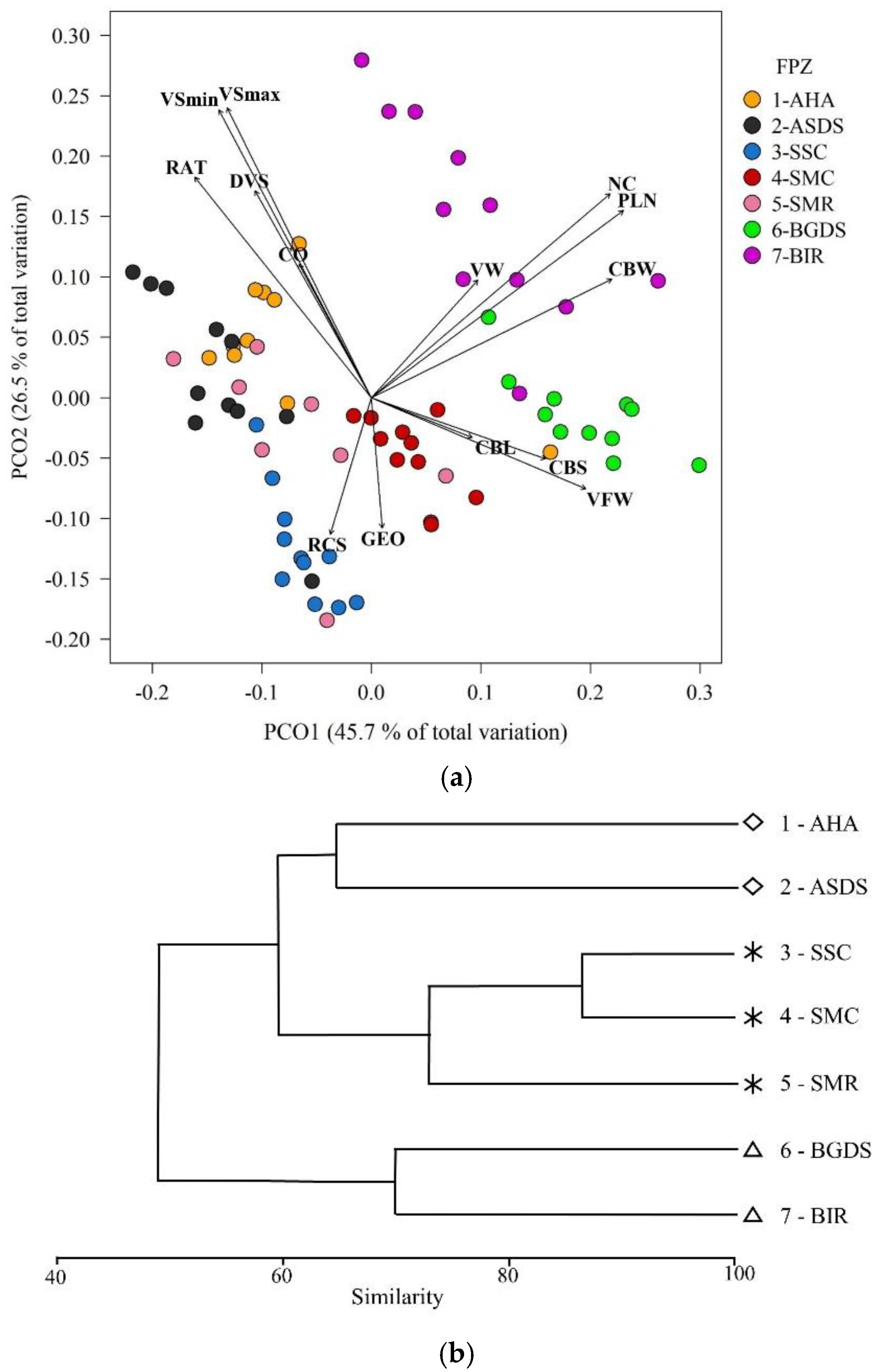
8809 sections of the total 8906 sections analysed clustered into eight groups or FPZs (Table S1). The remaining 97 river sections represented singular or rare sections. Of the eight identified FPZs, one comprised river sections exclusively of lakes and reservoir channel planforms and was also characterised by a higher channel belt wavelength and channel belt sinuosity (a total of 189 river sections) (Figure S1, Table S1). The remaining seven FPZs represented river channel planforms and were further analysed. Riverine FPZs were all significantly different among each other (PERMANOVA; Pseudo-F = 1287.7; P = 0.001; Table S2). Based on their similarities and geomorphic characteristics, the seven riverine FPZs identified for the south-central Chilean Andean rivers are described in Table 3. Figures S2–S4 exemplify river sections with the distinctive characteristics of the three FPZ groups identified: steep valley and downstream slope rivers, sinuous rivers and braided rivers. Variables at the channel scale, i.e., channel width, channel planform and number of channels, contributed the most to dissimilarity among FPZs (Figure 2a). FPZs AHA and ASDS were similar to each other and different from the remaining FPZs due to their steep downstream valley slope (Figure 2a). At 65% similarity, FPZs SSC, SMC and SMR clustered together due to higher channel sinuosity in these FPZs (Figure 2b). Both PCO and cluster analyses showed higher dissimilarity of braided rivers FPZs (BGDS and BIR) with the remaining FPZs. This dissimilarity was principally related to the greater number and density of channels in BGDS and BIR (Figure 2a).

3.2. Distribution and Compositions of Functional Process Zones in the Study Area

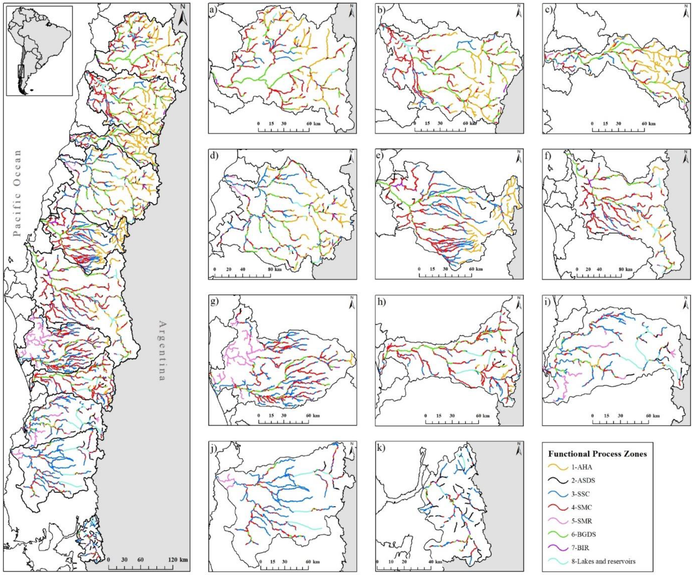
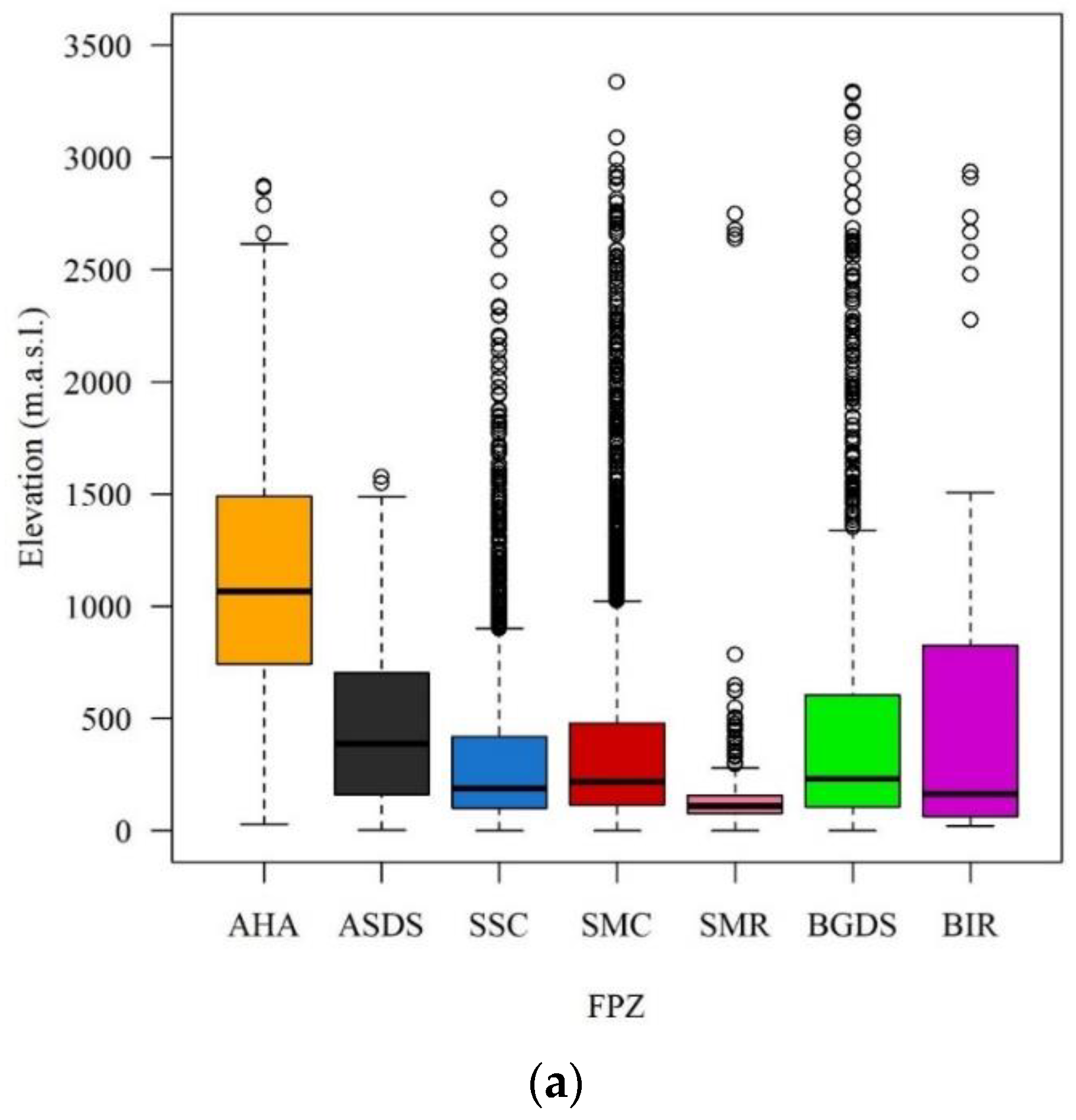
The identified FPZs showed a patchy distribution within the eleven assessed river basins (Figure 3). In general, high elevation steep slope rivers FPZs, particularly AHA, tended to be associated with Andean zones whereas BGDS was linked to the central valley and SMR reflected coastal range effects (Figure 3). However, there was no clear continuum from upstream to downstream as most FPZs were characterised by a wide range of elevations (Figure 4a). The exception was SMR, which was strongly associated with lowlands and thus was consistently present in a higher proportion of river basins characterised by lower elevations (Imperial, Valdivia and Bueno rivers; Figure 4b).
A clear latitudinal gradient of FPZs composition emerged among the eleven river basins analysed (Figure 5). Dominant FPZs, mostly SSC and SMC, were common in all the study area. However, the proportion of some FPZs significantly varied from North to South. For instance, northern basins (between the Maipo and the Biobío) were characterised by a higher proportion of AHA, which is consistent with their higher mean elevation (Figure 5a). Towards the South, the proportion of AHA tended to decrease and disappeared in the southernmost Puelo River basin. Indeed, the Puelo River also displayed a considerable proportion of steep valley and downstream slope rivers but was represented by ASDS. Furthermore, the proportion of braided rivers also decreased in more southern basins (Figure 5a).
At 65% similarity, the river basins were grouped in four clusters based on their FPZ composition, and this clustering was strongly associated with their latitudinal position (Figure 5b). The exception was the Toltén River basin, which groups with more northern basins. This is mainly explained by a lower proportion of SSC in the Toltén River basin in comparison with other geographically closer basins (Maule, Itata and Biobío). Furthermore, the Puelo River basin appeared to be dissimilar to all other basins because of the absence of AHA and a higher proportion of ASDS (Figure 5b).

4. Discussion

In this study, we described Functional Process Zones for eleven river basins in a wide latitudinal gradient of Andean rivers of the southern region of South America. Steep valley and downstream slope rivers, sinuous and braided river FPZs were identified. Although these broad categories of hydrogeomorphic patches are commonly known, here they emerged from statistical analyses using a top-down approach to characterize the geomorphic structure (digital elevation model data and remote sensing imagery) applied to small scale river sections [2]. Functional Process Zones (FPZs) are physically distinct sections of river networks that accommodate unique macroinvertebrates communities, fish communities [6,44] and food webs [11,45]. Therefore, identifying the geomorphic character of FPZs provides keystone knowledge to advance the understanding of the structure and functioning of river ecosystems and is a first step in managing resilient rivers so that they continue to provide ecosystem services.
Physical heterogeneity is a strong driver of river ecosystem function, and significant natural variation in physical conditions among rivers was expected [11,45]. At this scale of large river sections nested within river basins, seven FPZs captured the geomorphic variation in the eleven assessed river basins. Based on statistical analyses, the seven riverine FPZ were differentiated first by channel planform (number and density of channels), separating braided rivers (2 FPZs: BGDS and BIR) from other river typologies. Next, the non-braided rivers were divided into two categories, sinuous rivers (3 FPZs: SSC, SMC, and SMR) and steep valley and downstream slope rivers (2 FPZs: AHA and ASDS). We found that the proportion of occurrence of these river typologies showed a clear latitudinal pattern which was strongly related to the proportions of each river basin within the large morphostructural units of Chile. As such, the proportion of each river basin within the Andes Cordillera, Central Valley and Coastal Cordillera was a strong driver of the fluvial geomorphology and, thus, of the FPZs arrangement in each river network.

4.1. Functional Process Zones of the Chilean Andean Rivers

As predicted by the Riverine Ecosystem Synthesis (RES), FPZs are patchily distributed along river networks, and are partially predictable [2]. The sequence in which FPZs were placed varied within and among the eleven assessed river basins. Although the number of FPZs within each river basin was similar (6 or 7), the composition and evenness in the proportion of each FPZ was not homogeneous. As such, the Mataquito, Maule, Itata and Biobío River basins appeared to be more geodiverse [46,47] compared to the remaining river basins that were assessed. Consequently, a higher heterogeneity of habitats, biodiversity and ecosystem services may be expected in these basins [46,48]. In following paragraphs, we will discuss main characteristics of each of the principal identified FPZ groups.

4.2. Steep Valley and Downstream Slope Rivers

The steep valley and downstream slope rivers group is composed of AHA and ASDS that correspond to steep and narrow rivers. These rivers are characterised by high velocity, turbulent waters that transport significant volumes of materials, and have limited energy dissipation during large floods [49,50]. These two FPZs emerged from other river sections due to their higher values of downstream valley slope, confinement, and maximum and minimum valley slopes. AHA is primarily characterised by rivers with high downstream slope at high elevations, principally located in the headwaters of river basins with the highest maximum elevations within the Andes Cordillera. As such, AHA was more represented in northern rivers, between the Maipo and the Biobío basin. Indeed, the Andes Cordillera gradually decreases in altitude from the Maipo River basin towards the South and reaches significantly lower maximum altitudes southern to the Biobío River basin [51]. AHA represents headwater zones that function as sediment supply areas that rapidly convey sediment downstream [2].
ASDS is the second FPZ in the steep valley and downstream slope rivers group characterised by a single river channel and occurrence at lower elevations compared to AHA. Interestingly, ASDS was uncommon in all the assessed river basins with the exception of the Puelo River basin where it emerged as the most frequent FPZ. The Puelo River is the only river basin assessed within this study that is located in the Patagonian ecoregion [19], and consistently, it significantly differed from other assessed basins in its FPZ arrangement. Patagonian rivers originate in glaciers located in the eastern part of the Andes and are characterised by waters with a high particulate material content [19]. In contrast with other assessed basins, 80.1% of the area of the Puelo River basin lies within the Andes Cordillera, and the Coastal Cordillera is not present within this basin. Thus, most river sections of the Puelo Rivers were steep and of a single sinuous channel, a geomorphology similar to that described for other Patagonian rivers such as the Baker and Exploradores rivers [51,52].

4.3. Sinuous Rivers

Sinuous meandering rivers (sinuosity above 1.3) generally form on moderate-to-low slopes and are associated with well-developed floodplains [2]. Ref. [53] estimated that the dominant morphological pattern in Chilean rivers is the sinuous type. Our results were consistent with this estimation as sinuous river FPZs indeed represented the most abundant river sections across the eleven assessed river basins. Three sinuous FPZs emerged that could be further discriminated among them due to their sinuosity level and the number of channels. SSC represents low sinuosity single channel rivers, meanwhile SMCs are sinuous meandering rivers with more than one channel. SMR is characterised by a higher sinuosity and lower elevation compared to SSC and SMC FPZs. SSC and SMC were significantly predominant in river basins with large areas within the Central Valley (48–61%), such as the Imperial, Toltén, Valdivia and Bueno rivers. Although SSC and SMC occurred primarily in the Central Valley, patches of these FPZs were found widespread within the river networks. In turn, SMR was mostly related to lowland rivers within the Coastal Cordillera of the Imperial, Valdivia and Bueno River basins [54]. Indeed, these river basins are characterised by large headwater lakes of glacial origin and are classified as “rivers of constant flow, low gradient and lacustrine regulation” [15].

4.4. Braided Rivers

Headwater zones of Andean river basins occur in erodible volcanic mountains that contribute significant volumes of sediment [49]. This sediment supply is subsequently redeposited during floods resulting in braided rivers [50]. Two FPZs identified in the study area represented braided rivers and these can be differentiated between them by lithology. BIR occurs only on intrusive rocks, meanwhile BGDS is present on volcanic and volcanic-sedimentary sequences. BGDS was more frequent compared to BIR along all the assessed latitudinal gradient. Consistently, the dominant geology in river basins between the Maipo and Toltén river basins is composed of >37% of volcanic and volcanic-sedimentary sequences. Indeed, braided rivers have been previously described in the Chilean Central Valley [49]. However, we found that braided sections were widespread within the river networks as predicted by RES, with longer sections in the middle and lower zones within the assessed basins.
Braided rivers commonly have a higher river metabolism and nutrient uptake because of their greater spatial heterogeneity and hydraulic connectivity between the river channel and both floodplains and hyporheic zone [50]. Furthermore, braided and wandering gravel-bed rivers are also generally characterised by the presence of dynamic vegetated patches within the river corridor [55]. Ref. [51] found a tendency of an increase in the proportion of fluvial islands relative to the active channel area in Chilean rivers between 33° and 39° S. Here, we found a clear latitudinal pattern of a decreasing proportion of braided rivers within basins between 32° and 41° S. Indeed, the northern river basins (Maipo, Rapel, Mataquito and Maule) are characterised by >40% of their area being located in the Andes and higher maximum elevations that drive sediment production and transport. In contrast, the more southern rivers (Itata, Biobío, Imperial, Toltén, Valdivia and Bueno) are characterised by a higher ratio of their surface being located within the Central Valley. Furthermore, the Toltén, Valdivia and Bueno rivers accommodate large headwater lakes that serve as sediment traps.

4.5. Contributions to River Classification and Its Relation with Fish Fauna Distribution

Research of river geomorphology has not received much attention in Chile until recently, when some projects focusing on fluvial form, processes and dynamics as a tool to develop sustainable river management strategies have started [56]. Previous classifications of rivers in Chile were based on hydrological regime [15], eco-hydrology [21], fractal dimensions [16,17] or ecoregions [19,57]. Eco-hydrological classification was carried out following the River Continuum Concept, using four large-scale controlling factors (climate, flow, geology and catchment relative position), land-use as mesoscale factor and slope as a variable at the reach scale [21,58]. Subsequently, River Environmental Classification was obtained based on the hierarchical superposition of these six factors [21]. Fractal properties of 23 Chilean fluvial networks were studied using eight morphometric properties by [16]. While this classification helps to comprehend the drainage patterns, it is difficult to relate it to the riverine ecosystem function. Ref. [19] proposed the construction of a typology system based on the European Water Framework Directive that includes expert opinions and classifies ecoregions and water bodies using categorical ranges of variables at the basin and reach scale. More recently, ref. [51] proposed a geomorphic hierarchical approach at the basin and reach scales that identifies clusters with homogeneous geomorphic characteristics for 19 rivers (sub-basins of larger Andean basins). Despite each of the previous classifications advancing the knowledge of river systems in Chile, to understand the functioning of riverine ecosystems, a hierarchical top-down approach with variables derived at all hierarchical geomorphic scales (basin, valley and channel) should be applied [2]. Only such an approach allows one to assess processes that are commensurate with the scale essential for the comprehension of riverine ecosystems and the entire river network [2]. As such, our work is the first to date geomorphic classifications based on the measurements of 16 variables at the basin, valley and channel scales.
The only previous study that identified FPZs in Chilean rivers was performed by [6] and focused on two river basins that are also included in the present study (Biobío and Imperial River basins). Ref. [6] analysed only the principal river network and at reach sections of 5 km, obtaining seven FPZs. From these, Andean and Sub-Andean FPZs coincided with AHA, Central Valley cobble dominated, Central Valley gravel dominated with SSC and SMC, and Lowland with BGDS. SMR was not identified by these authors since they did not include the river network in the Coastal Cordillera. Refs. [6,10] found that each of these FPZs hosted unique fish and macroinvertebrate communities in the Biobío River basin. Our river basin classification based on the arrangement of FPZs in each basin also reveals important coincidences with the distribution of the Chilean native fish fauna [59]. As such, the cluster conformed by the Maipo, Rapel and Mataquito river basins overlap with the Central area of fish endemism; the cluster of the Maule, Itata and Biobío river basins coincides with the South-Central area of endemism; the cluster of the Imperial, Valdivia and Bueno concurs with the Southern endemism area; and finally, the Puelo River clustered at low similarity with other southern rivers representing the Patagonian Province. Only the Toltén basin appears incongruent with the native fish species distribution since it was placed together with the northern rivers due to a large proportion of its basin being in the Andes Cordillera. Indeed, the Toltén River basin was not classified by [59] in any of the endemism areas due to a lack of data when the classification was proposed.

4.6. FPZs, Anthropic Alterations and River Basin Management

There is growing evidence of significant changes and a loss of geodiversity (i.e., variety of geological, geomorphic and soil features) in multiple river basins worldwide [46]. Indeed, as shown for European rivers, principal changes that have occurred during the late twentieth century are river channel narrowing and incision, simplification of channel patterns, reduction in lateral activity and bed sediment storage and fluxes [60]. Apart from these changes in river channels, at the valley scale, a significant reduction in floodplain areas has been reported [61]. Furthermore, there is growing evidence of a direct relation of these geomorphic changes with freshwater biodiversity loss [60]. In comparison with European rivers, Chilean river basins have been exposed to anthropogenic alterations to a lesser extent and for a shorter period of time and, therefore, it is still possible to understand more natural river morphodynamics at a basin scale. However, in some river basins, changes on a river reach scale are already evidenced [62,63,64]. As such, changes in planform and significant channel incision but without changes in vegetation cover have been reported as an effect of instream gravel mining in a 22 km long river reach in the Maipo River [64]. In contrast, ref. [62] have reported a significant increase in vegetation cover (mainly due to the colonisation of the river channel by invasive species such as the silver wattle Acacia dealbata) in the Maule River in a 36 km long river reach downstream of a hydroelectric dam operating since 1985. This increase is attributed to the combined effects of hydropower operation and ten years of drought and have caused a significant loss of geomorphic dynamics and channel stabilisation [62]. In addition, the Rapel hydropower dam was reported to cause significant changes in the channel planform and geomorphic dynamics of the Rapel River [63]. Specifically, the 19 km long river reach below the dam operating since 1968 changed from a braided to a single channel river [63]. This change is reflected in our results, as the river reach of the Rapel River just below the Rapel hydropower dam emerged as ASDS, which was unexpected in the lower part of the basin and only appeared in this basin and in this particular zone. As such, the appearance of this FPZ in this zone may be attributed to dam effects. Such a change was not observed in the Maule and Biobío basins that also accommodate hydropower dams, most probably due to the much shorter operation time of these dams (the Maule hydropower dam was constructed in 1985, whereas the Biobío hydropower dams were constructed in 1994, 2004 and 2014; [35]). This corroborates that changes in river dynamics reflected in geomorphic changes at the FPZ scale occur at a large timescale (decades).
To conserve the resilience of riverine ecosystems and assure the ecosystem services they provide for the society, exact knowledge of the physical structure of different river sections that govern their ecological structure and function is essential [2]. Statistically rigorous classification of river networks in Chilean river basins based on geomorphic features at basin, valley and channel scales presented here provided an efficient framework for river classification and allowed the identification and characterisation of distinct FPZs and their spatial arrangement. Knowledge of FPZs may allow effective selection of sites for riverine ecosystem monitoring, identification of reference condition sites to assess the effects of anthropogenic activities on riverine ecosystems and guide river rehabilitation actions. Our FPZ classification captured the geomorphic diversity that coincided with the latitudinal and altitudinal gradients of Chilean Andean river basins and was strongly related to the hydrological characteristics of these river basins and large scale spatial distribution of fish fauna endemism. As such, river geomorphology assessed by FPZ classification that is strongly tied up with hydrology and ecology hierarchies provides robust operational units that can be instrumental for river ecosystem monitoring and management at a basin scale.

Supplementary Materials

The following supporting information can be downloaded at: https://www.mdpi.com/article/10.3390/w14172614/s1.

Author Contributions

Conceptualization, E.H. and K.G.; methodology, E.H, A.Z., G.D., A.M., P.A., O.L. and K.G.; software, A.Z.; validation, E.H., A.Z., P.A., O.L. and K.G.; formal analysis, E.H., A.Z., K.G.; investigation, E.H, A.Z., G.D., A.M., P.A., O.L. and K.G.; resources, E.H., K.G. and O.L.; writing—original draft preparation, E.H. and K.G.; writing—review and editing, E.H, A.Z., G.D., A.M., P.A., O.L. and K.G.; funding acquisition, E.H. All authors have read and agreed to the published version of the manuscript.

Funding

This research was funded by FONDECYT 1190647 and the APC was funded by FONDECYT 1190647.

Data Availability Statement

Not applicable.

Acknowledgments

We acknowledge Rocío Bocaletti, Paulina Vega, Katherine Arias, Macarena Ramírez, Valentina Rivas, and Rocío Pedreros for her help with the digitalization process.

Conflicts of Interest

The authors declare no conflict of interest.

References

  1. Thorp, J.H.; Thoms, M.C.; Delong, M.D. The riverine ecosystem synthesis: Biocomplexity in river networks across space and time. River Res. Appl. 2006, 22, 123–147. [Google Scholar] [CrossRef]
  2. Thorp, J.H.; Thoms, M.C.; Delong, M.D. The Riverine Ecosystem Synthesis. Towards Conceptual Cohesiveness in River Science; Aquatic Ecology Series, Ed.; Academic Press: San Diego, CA, USA, 2008. [Google Scholar]
  3. Dollar, E.; James, C.; Rogers, K.; Thoms, M. A framework for interdisciplinary understanding of rivers as ecosystems. Geomorphology 2007, 89, 147–162. [Google Scholar] [CrossRef]
  4. Delong, M.D.; Thoms, M.C. An Ecosystem Framework for River Science and Management. In River Science: Research and Management for the 21st Century; Gilvear, D.J., Greenwood, M.T., Thoms, M.C., Wood, P.J., Eds.; Wiley Blackwell: Chichester, UK, 2016; pp. 12–36. [Google Scholar]
  5. Thoms, M.; Parsons, M. Eco-Geomorphology: An Interdisciplinary Approach to River Science; International Association of Hydrological Sciences: Wallingford, UK, 2002; Volume 276, pp. 113–119. [Google Scholar]
  6. Elgueta, A.; Thoms, M.C.; Górski, K.; Díaz, G.; Habit, E.M. Functional process zones and their fish communities in temperate Andean river networks. River Res. Appl. 2019, 35, 1702–1711. [Google Scholar] [CrossRef]
  7. Maasri, A.; Pyron, M.; Arsenault, E.R.; Thorp, J.H.; Mendsaikhan, B.; Tromboni, F.; Minder, M.; Kenner, S.J.; Costello, J.; Chandra, S.; et al. Valley-scale hydrogeomorphology drives river fish assemblage variation in Mongolia. Ecol. Evol. 2021, 11, 6527–6535. [Google Scholar] [CrossRef]
  8. Thoms, M. An introduction to river science: Research and applications. In River Science: Research and Management for the 21st Century; Gilvear, D.J., Greenwood, M.T., Thoms, M.C., Wood, P.J., Eds.; Wiley Blackwell: Chichester, UK, 2016; pp. 1–11. [Google Scholar]
  9. Likens, G.E.; Walker, K.F.; Davies, P.E.; Brookes, J.; Olley, J.; Young, W.J.; Thoms, M.C.; Lake, P.S.; Gawne, B.; Davis, J.; et al. Ecosystem science: Toward a new paradigm for managing Australia’s inland aquatic ecosystems. Mar. Freshw. Res. 2009, 60, 271–279. [Google Scholar] [CrossRef]
  10. Elgueta, A.; Górski, K.; Thoms, M.; Fierro, P.; Toledo, B.; Manosalva, A.; Habit, E. Interplay of geomorphology and hydrology drives macroinvertebrate assemblage responses to hydropeaking. Sci. Total Environ. 2020, 768, 144262. [Google Scholar] [CrossRef]
  11. DeBoer, J.A.; Thoms, M.C.; Delong, M.D.; Parsons, M.E.; Casper, A.F. Heterogeneity of ecosystem function in an “Anthropocene” river system. Anthropocene 2020, 31, 1–11. [Google Scholar] [CrossRef]
  12. Van Looy, K.; Tonkin, J.D.; Floury, M.; Leigh, C.; Soininen, J.; Larsen, S.; Heino, J.; Poff, N.L.; Delong, M.; Jähnig, S.C.; et al. The three Rs of river ecosystem resilience: Resources, recruitment, and refugia. River Res. Appl. 2019, 35, 107–120. [Google Scholar] [CrossRef]
  13. Charrier, R.; Ramos, V.A.; Tapia, F.; Sagripanti, L. Tectono-stratigraphic evolution of the Andean Orogen between 31 and 37°S (Chile and Western Argentina). Geol. Soc. Lond. Spéc. Publ. 2014, 399, 13–61. [Google Scholar] [CrossRef]
  14. Habit, E.; García, A.; Díaz, G.; Arriagada, P.; Link, O.; Parra, O.; Thoms, M. River science and management issues in Chile: Hydropower development and native fish communities. River Res. Appl. 2018, 35, 489–499. [Google Scholar] [CrossRef]
  15. Niemeyer, H.; Hidrografía, C.P. Geografía de Chile; Instituto Geográfico Militar: Santiago, Chile, 1984. [Google Scholar]
  16. Martínez, F.; Manríquez, H.; Ojeda, A.; Olea, G.A. A Fractal Description of Fluvial Networks in Chile: A Geography Not as Crazy as Thought. 2021. Available online: https://www.preprints.org/manuscript/202112.0471/v1 (accessed on 22 August 2022).
  17. Martinez, F.; Ojeda, A.; Manríquez, H. Application of Fractal Theory to Describe the Morphological Complexity of Large Stream Networks in Chile. Water Resour. 2022, 49, 301–310. [Google Scholar] [CrossRef]
  18. Alvarez-Garreton, C.; Mendoza, P.A.; Boisier, J.P.; Addor, N.; Galleguillos, M.; Zambrano-Bigiarini, M.; Lara, A.; Puelma, C.; Cortes, G.; Garreaud, R.; et al. The CAMELS-CL dataset: Catchment attributes and meteorology for large sample studies—Chile dataset. Hydrol. Earth Syst. Sci. 2018, 22, 5817–5846. [Google Scholar] [CrossRef]
  19. Fuster, R.; Escobar, C.; Lillo, G.; de la Fuente, A. Construction of a typology system for rivers in Chile based on the European Water Framework Directive (WFD). Environ. Earth Sci. 2014, 73, 5255–5268. [Google Scholar] [CrossRef]
  20. Vila, I.; Fuentes, L.; Contreras, M. Peces límnicos de Chile. Bol. Mus. Nac. Hist. Nat. 1999, 48, 61–75. [Google Scholar]
  21. Peredo Parada, M.M.; Martinez-Capel, F.; Quevedo Tejada, D.I.; Hernández Mascarell, A.B. Implementation of an eco-hydrological classification in Chilean rivers. Gayana 2011, 75, 26–38. [Google Scholar] [CrossRef]
  22. INE. Synthesis of Results of the 2017 Census. Instituto Nacional de Estadística. Available online: https://www.censo2017.cl/descargas/home/sintesis-de-resultados-censo2017.pdf (accessed on 22 August 2022).
  23. Garreaud, R.D.; Vuille, M.; Compagnucci, R.; Marengo, J. Present-day South. American climate. Palaeogeogr. Palaeoclimatol. Palaeoecol. 2009, 281, 180–195. [Google Scholar] [CrossRef]
  24. Valdés-Pineda, R.; Cañón, J.; Valdés, J.B. Multi-decadal 40-to 60-year cycles of precipitation variability in Chile (South America) and their relationship to the AMO and PDO signals. J. Hydrol. 2018, 556, 1153–1170. [Google Scholar] [CrossRef]
  25. Beck, H.E.; Zimmermann, N.E.; McVicar, T.R.; Vergopolan, N.; Berg, A.; Wood, E.F. Present and future Köppen-Geiger climate classification maps at 1-km resolution. Sci. Data 2018, 5, 180214. [Google Scholar] [CrossRef]
  26. Falvey, M.; Garreaud, R. Regional cooling in a warming world: Recent temperature trends in the southeast Pacific and along the west coast of subtropical South America (1979–2006). J. Geophys. Res. Earth Surf. 2009, 114. [Google Scholar] [CrossRef]
  27. Escobar, F.; Aceituno, P. Influencia del fenómeno ENSO sobre la precipitación nival en el sector andino de Chile central durante el invierno. Bull. De L’institut Français D’études Andin. 1998, 27, 753–759. Available online: https://www.persee.fr/doc/bifea_0303-7495_1998_num_27_3_1328 (accessed on 22 August 2022).
  28. Montecinos, A.; Aceituno, P. Seasonality of the ENSO-Related Rainfall Variability in Central Chile and Associated Circulation Anomalies. J. Clim. 2003, 16, 281–296. [Google Scholar] [CrossRef]
  29. Urrutia, R.B.; Lara, A.; Villalba, R.; Christie, D.A.; Le Quesne, C.; Cuq, A. Multicentury tree ring reconstruction of annual streamflow for the Maule River watershed in south central Chile. Water Resour. Res. 2011, 47. [Google Scholar] [CrossRef] [Green Version]
  30. Garreaud, R. Warm Winter Storms in Central Chile. J. Hydrometeorol. 2013, 14, 1515–1534. [Google Scholar] [CrossRef]
  31. Jordan, T.E.; Isacks, B.L.; Allmendinger, R.W.; Brewer, J.A.; Ramos, V.A.; Ando, C.J. Andean tectonics related to geometry of subducted Nazca plate. GSA Bull. 1983, 94, 341–361. [Google Scholar] [CrossRef]
  32. Bonilla, C.A.; Johnson, O.I. Soil erodibility mapping and its correlation with soil properties in Central Chile. Geoderma 2012, 189–190, 116–123. [Google Scholar] [CrossRef]
  33. Link, O.; Habit, E. Requirements and boundary conditions for fish passes of non-sport fish species based on Chilean experiences. Rev. Environ. Sci. Bio/Technol. 2014, 14, 9–21. [Google Scholar] [CrossRef]
  34. Laborde, A.; Habit, E.; Link, O.; Kemp, P. Strategic methodology to set priorities for sustainable hydropower development in a biodiversity hotspot. Sci. Total Environ. 2020, 714, 136735. [Google Scholar] [CrossRef]
  35. Díaz, G.; Arriagada, P.; Górski, K.; Link, O.; Karelovic, B.; Gonzalez, J.; Habit, E. Fragmentation of Chilean Andean rivers: Expected effects of hydropower development. Rev. Chil. de Hist. Nat. 2019, 92, 1. [Google Scholar] [CrossRef]
  36. Arriagada, P.; Dieppois, B.; Sidibe, M.; Link, O. Impacts of Climate Change and Climate Variability on Hydropower Potential in Data-Scarce Regions Subjected to Multi-Decadal Variability. Energies 2019, 12, 2747. [Google Scholar] [CrossRef]
  37. Williams, B.S.; D’Amico, E.; Kastens, J.H.; Thorp, J.H.; Flotemersch, J.E.; Thoms, M.C. Automated riverine landscape characterization: GIS-based tools for watershed-scale research, assessment, and management. Environ. Monit. Assess. 2013, 185, 7485–7499. [Google Scholar] [CrossRef]
  38. Thoms, M.; Scown, M.; Flotemersch, J. Characterization of River Networks: A GIS Approach and Its Applications. JAWRA J. Am. Water Resour. Assoc. 2018, 54, 899–913. [Google Scholar] [CrossRef]
  39. Sernageomin, S. Mapa Geológico de Chile: Versión Digital. Servicio Nacional de Geología y Minería, Publicación Geológica Digital. 2003, p. 4. Available online: Chrome-extension://efaidnbmnnnibpcajpcglclefindmkaj/http://www.ipgp.fr/~dechabal/Geol-millon.pdf (accessed on 22 August 2022).
  40. Rinaldi, M.; Surian, N.; Comiti, F.; Bussettini, M.; Belletti, B.; Nardi, L.; Lastoria, B.; Golfieri, B. Guidebook for the Evaluation of Stream Morphological Conditions by the Morphological Quality Index (MQI). 2016. Available online: https://reformrivers.eu/guidebook-evaluation-stream-morphological-conditions-morphological-quality-index-mqi.html (accessed on 22 August 2022).
  41. Gower, J.C. A General Coefficient of Similarity and Some of Its Properties. Biometrics 1971, 27, 857. [Google Scholar] [CrossRef]
  42. Anderson, M.J. Permutational Multivariate Analysis of Variance (PERMANOVA); Balakrishnan, N., Colton, T., Everitt, B., Piegorsch, W., Ruggeri, F., Teugels, J.L., Eds.; John Wiley & Sons, Ltd.: Hoboken, NJ, USA, 2017; pp. 1–15. [Google Scholar] [CrossRef]
  43. Clarke, K.R.; Gorleya, R.N.; Somerfield, P.J.; Warwick, R.M. Change in Marine Communities: An Approach to Statistical Analysis and Interpretation, 3rd ed.; PRIMER-E: Plymouth, UK, 2014; Available online: https://updates.primer-e.com/primer7/manuals/Methods_manual_v7.pdf (accessed on 22 August 2022).
  44. Maasri, A.; Thorp, J.H.; Kotlinski, N.; Kiesel, J.; Erdenee, B.; Jähnig, S.C. Variation in macroinvertebrate community structure of functional process zones along the river continuum: New elements for the interpretation of the river ecosystem synthesis. River Res. Appl. 2021, 37, 665–674. [Google Scholar] [CrossRef]
  45. Thoms, M.; Delong, M.; Flotemersch, J.; Collins, S. Physical heterogeneity and aquatic community function in river networks: A case study from the Kanawha River Basin, USA. Geomorphology 2017, 290, 277–287. [Google Scholar] [CrossRef]
  46. Alahuhta, J.; Ala-Hulkko, T.; Tukiainen, H.; Purola, L.; Akujärvi, A.; Lampinen, R.; Hjort, J. The role of geodiversity in providing ecosystem services at broad scales. Ecol. Indic. 2018, 91, 47–56. [Google Scholar] [CrossRef]
  47. Tukiainen, H.; Maliniemi, T.; Alahuhta, J.; Hjort, J.; Lindholm, M.; Salminen, H.; Vilmi, A.; Heino, J. Quantifying alpha, beta and gamma geodiversity. Prog. Phys. Geogr. Earth Environ. 2022, 1–12. [Google Scholar] [CrossRef]
  48. Burnett, M.R.; August, P.V.; Brown, J.H., Jr.; Killingbeck, K.T. The Influence of Geomorphological Heterogeneity on Biodiversity I. A Patch-Scale Perspective. Conserv. Biol. 1998, 12, 363–370. [Google Scholar] [CrossRef]
  49. Harris-Pascal, D. Fluvial Geomorphology of the Bió-Bió Basin. 2014: ENVS 6312. p. 24. Available online: https://www.academia.edu/11802085/Geomorphology_and_microcatchment_management_of_the_Bio_Bio_Basin_Chile (accessed on 22 August 2022).
  50. Wohl, E. Geomorphic context in rivers. Prog. Phys. Geogr. Earth Environ. 2018, 42, 841–857. [Google Scholar] [CrossRef]
  51. Ulloa, H.; Iroumé, A.; Picco, L.; Vergara, G.; Sitzia, T.; Mao, L.; Mazzorana, B. Do the morphological characteristics of Chilean gravel-bed rivers exhibit latitudinal patterns? J. S. Am. Earth Sci. 2020, 99, 102522. [Google Scholar] [CrossRef]
  52. Bañales-Seguel, C.; Salazar, A.; Mao, L. Hydro-morphological characteristics and recent changes of a nearly pristine river system in Chilean Patagonia: The Exploradores river network. J. S. Am. Earth Sci. 2019, 98, 102444. [Google Scholar] [CrossRef]
  53. Martínez, F.; Madrid, H. Sinuosidad y Dimensión Fractal de Cauces Chilenos. Tecnol. Y Cienc. Del Agua 2019, 13, 172–224. [Google Scholar] [CrossRef]
  54. Candel, J.H.J.; Makaske, B.; Kijm, N.; Kleinhans, M.G.; Storms, J.E.A.; Wallinga, J. Self-constraining of low-energy rivers explains low channel mobility and tortuous planforms. Depos. Rec. 2020, 6, 648–669. [Google Scholar] [CrossRef]
  55. Gurnell, A.M.; Corenblit, D.; García de Jalón, D.; González del Tánago, M.; Grabowski, R.C.; O’Hare, M.T.; Szewczyk, M. A Conceptual Model of Vegetation-hydrogeomorphology Interactions within River Corridors. River Res. Appl. 2015, 32, 142–163. [Google Scholar] [CrossRef]
  56. Andreoli, A.; Mao, L.; Iroume, A.; Arumi, J.L.; Nardini, A.; Pizarro, R.; Caamaño, D.; Meier, C.; Link, O. The need for a hydromorphological approach to Chilean river management. Rev. Chil. Hist. Nat. 2012, 85, 339–343. [Google Scholar] [CrossRef]
  57. Abell, R.; Thieme, M.L.; Revenga, C.; Bryer, M.; Kottelat, M.; Bogutskaya, N.; Coad, B.; Mandrak, N.; Balderas, S.C.; Bussing, W.; et al. Freshwater Ecoregions of the World: A New Map of Biogeographic Units for Freshwater Biodiversity Conservation. BioScience 2008, 58, 403–414. [Google Scholar] [CrossRef]
  58. Vannote, R.L.; Minshall, G.W.; Cummins, K.W.; Sedell, J.R.; Cushing, C.E. The river continuum concept. Can. J. Fish. Aquatic Sci. 1980, 37, 130–137. [Google Scholar] [CrossRef]
  59. Dyer, B. Revisión sistemática y biogeográfica de los peces dulceacuícola de Chile. Estud. Oceanol. 2000, 19, 77–98. [Google Scholar]
  60. Downs, P.W.; Piégay, H. Catchment-scale cumulative impact of human activities on river channels in the late Anthropocene: Implications, limitations, prospect. Geomorphology 2019, 338, 88–104. [Google Scholar] [CrossRef]
  61. Maaß, A.-L.; Schüttrumpf, H.; Lehmkuhl, F. Human impact on fluvial systems in Europe with special regard to today’s river restorations. Environ. Sci. Eur. 2021, 33, 1–13. [Google Scholar] [CrossRef]
  62. Pacheco, F.; Rojas, O.; Hernández, E.; Caamaño, D. Effects on Fluvial Geomorphology and Vegetation Cover following Hydroelectric Power Plant Operation: A Case Study in the Maule River (Chile). Water 2022, 14, 1673. [Google Scholar] [CrossRef]
  63. Alcayaga, H.; Palma, S.; Caamaño, D.; Mao, L.; Soto-Alvarez, M. Detecting and quantifying hydromorphology changes in a chilean river after 50 years of dam operation. J. S. Am. Earth Sci. 2019, 93, 253–266. [Google Scholar] [CrossRef]
  64. Arróspide, F.; Mao, L.; Escauriaza, C. Morphological evolution of the Maipo River in central Chile: Influence of instream gravel mining. Geomorphology 2018, 306, 182–197. [Google Scholar] [CrossRef]
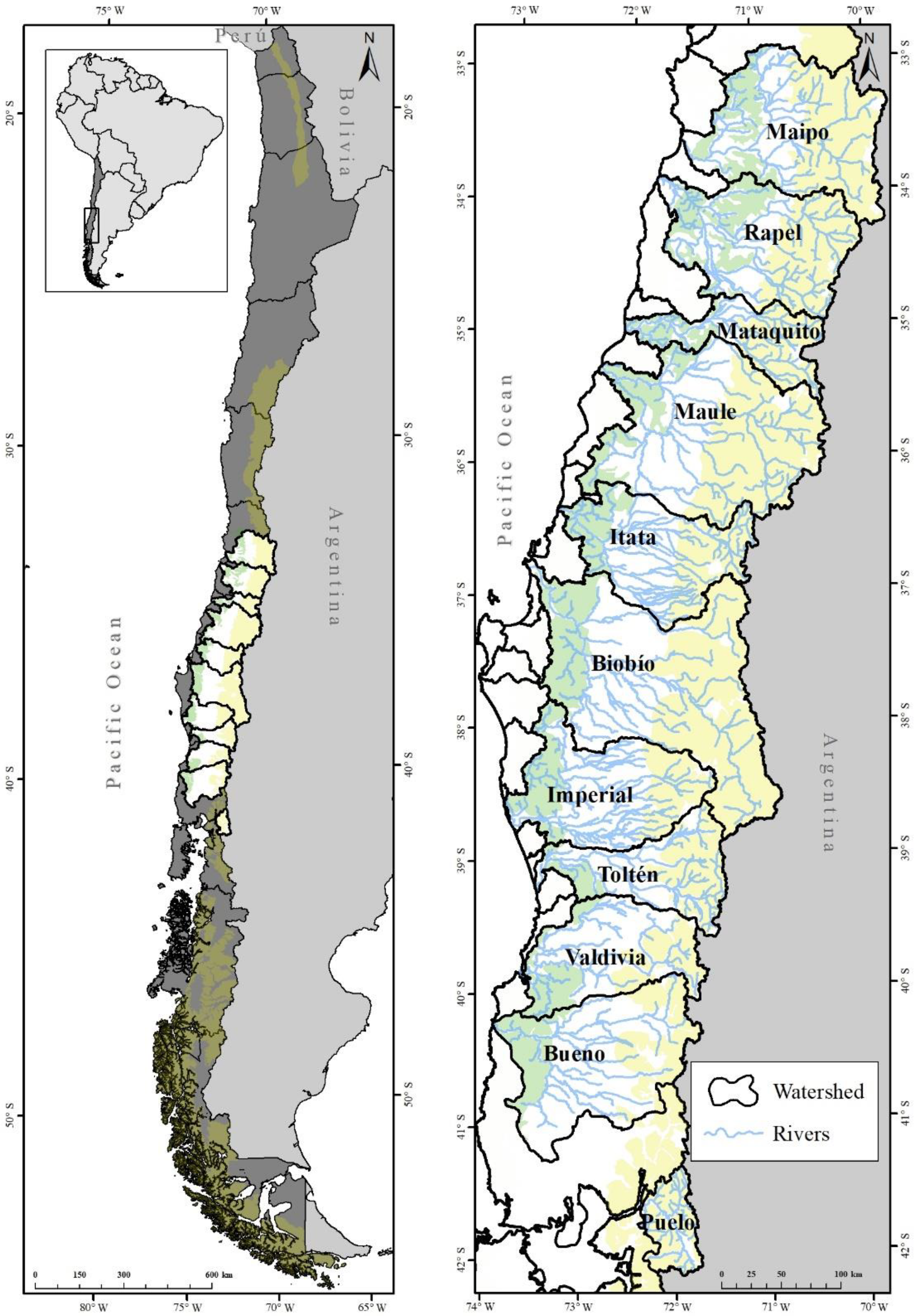
Figure 1. Geographic location of the eleven studied river basins and their river networks assessed in this study. Yellow area represents the Andes Cordillera; white area is the Central Valley; and green area corresponds to the Coastal Cordillera.
Water 14 02614 g001
Figure 2. (a) Principal coordinate analysis (PCO) diagram showing the position of the riverine FPZs in relation to the geomorphic variables. (b) Cluster of the seven FPZs showing similarity at 60%. See variable abbreviations in Table 2.
Water 14 02614 g002
Figure 3. Position of the identified FPZs in each of the eleven river networks. (a) Maipo; (b) Rapel; (c) Mataquito; (d) Maule; (e) Itata; (f) Biobío; (g) Imperial; (h) Toltén; (i) Valdivia; (j) Bueno; (k) Puelo. Singular or rare sections are not drawn.
Water 14 02614 g003
Figure 4. (a) Range of elevations of each FPZs in the eleven river basins. (b) Mean elevation of each of the river basin calculated from elevations of all defined river sections (symbols indicate groups at 65% similarity).
Water 14 02614 g004aWater 14 02614 g004b
Figure 5. (a) Proportion of riverine FPZs in each river basin (ordered from North to South). (b) Similarity among river basins based on their geomorphic characteristics. Symbols represent clusters at 65% similarity.
Water 14 02614 g005
Table 1. Geographic position, catchment area, maximum altitude, climate, mean annual precipitation and mean annual discharge at the mouth of eleven studied river basins. Csa, hot-summer Mediterranean climate; Csb, warm-summer Mediterranean climate; Cfb, Oceanic climate (Marine west coast) [25].
BasinLatitude
(° ′)
Longitude
(° ′)
Area
(km2)
Maximum Altitude
(m)
Predominant ClimateFlow Regime *PPMA
(mm)
QMA (m3/s)Fragmentation Index **
Maipo32°55′–34°18′ S69°48′–71°38′ W15,2736546Csa-CsbSnowmelt6501340.393
Rapel33°54′–35°00′ S70°01′–71°51′ W13,7665138Csa-CsbSnowmelt-rain8821690.463
Mataquito34°48′–35°38′ S70°24′–72°11′ W63324058CsbSnowmelt-rain13731130.080
Maule35°06′–36°35′ S70°21′–72°27′ W21,0523931CsbSnowmelt-rain14004950.361
Itata36°12′–37°20′ S71°02′–72°52′ W11,3263178CsbSnowmelt-rain17643310.044
Biobío36°52′–38°54′ S70°50′–73°12′ W24,3693487CsbRain18739710.436
Imperial37°49′–38°58′ S71°27′–73°30′ W12,6683066Csb-CfbRain20562640.002
Toltén38°36′–39°38′ S71°24′–73°14′ W84483710CfbRain20625400.016
Valdivia39°18′–40°12′ S71°36′–73°24′ W10,2442824CfbRain25925460.021
Bueno39°54′–41°17′ S71°40′–73°43′ W15,3662410CfbRain28613940.025
Puelo41°21′–42°09′ S71°46′–72°22′ W30943343CfbSnowmelt-rain23896290.001
* from [24]; ** estimated based on [35].
Table 2. Variables used for the determination of the Functional Process Zones. m: meters, mm: millimetres; DL: dimensionless; DEM: Digital Elevation Model.
ScaleVariableUnitAbbreviationData Source
BasinElevationMELE12.5 m DEM CIREN
Dominant GeologyDLGEOChile geological map 1:1,000,000
Mean annual precipitationMmPREWorldClim Rainfall Raster
ValleyValley floor widthMVFWFloodplain Shapefile
Valley widthMVWValley Shapefile
Ratio of valley width to valley floor widthMRATFloodplain and valley Shapefiles
Right valley slopedegreesRVSSlope Raster
Left valley slopedegreesLVSSlope Raster
Downstream valley slopedegreesDVSSlope Raster
ChannelChannel belt widthMCBWChannel Shapefile
Channel belt wavelengthMCBLChannel Shapefile
Channel belt sinuosityDLCBSChannel Shapefile
River network Shapefile
Channel River sinuosityDLRCSRiver network Shapefile
Valley Shapefile
Channel planformDLPLNSatellite images
Number of channels-NCSatellite images
ConfinementDLCOFloodplain and channel Shapefiles
Table 3. Main characteristics of the riverine Functional Process Zones identified for eleven river basins.
Common Characteristics at 60% SimilarityNumberFPZ NameFPZ AbbreviationGeomorphological Characterization
Steep valley and downstream slope rivers 1Andean High Altitude FPZAHAHigh altitude rivers (>1000 m.a.s.l.), narrow channel in volcano-sedimentary sequences.
2Andean Steep Downstream Slope FPZASDSSteep downstream slope rivers, narrow channel in intrusive rock.
Sinuous rivers3Sinuous Single-channel FPZSSCSinuous rivers with single channel.
4Sinuous Multi-channel FPZSMCSinuous rivers with multiple channels.
5Sinuous Metamorphic Rock FPZSMRHighly sinuous rivers at low elevations in metamorphic rock.
Braided rivers6Braided Gentle Downstream Slope FPZBGDSBraided gentle downstream slope with wide channel and valley.
7Braided Intrusive Rock FPZBIRBraided rivers with wide channel and valley in intrusive rocks.
Publisher’s Note: MDPI stays neutral with regard to jurisdictional claims in published maps and institutional affiliations.