The PlaceMarker Survey: A Place-Based Tool for Supporting the Monitoring and Appraisal of River-Related Projects and Natural Capital Assessments
Abstract
:1. Introduction
2. The PlaceMarker Survey
2.1. Key Features
2.2. Structure of the PlaceMarker Survey, Measurements, Indices, and Impression-Based Assessments
3. Development and Testing of the PlaceMarker Survey: Some Early Results and Implications
4. Discussion
5. Conclusions
Supplementary Materials
Author Contributions
Funding
Institutional Review Board Statement
Informed Consent Statement
Data Availability Statement
Acknowledgments
Conflicts of Interest
References
- Adams, W.M. The value of valuing nature. Science 2014, 346, 549–551. [Google Scholar] [CrossRef]
- De Vries, S.; Verheij, R.A.; Groenewegen, P.P.; Spreeuwenberg, P. Natural Environments—Healthy Environments? An Exploratory Analysis of the Relationship Between Greenspace and Health. Environ. Plan. A 2003, 35, 1717–1731. [Google Scholar] [CrossRef]
- Available online: www.valuing-nature.net (accessed on 5 May 2022).
- HM Government. A Green Future: Our 25 Year Plan to Improve the Environment; HM Government: London, UK, 2018; 151p. Available online: www.gov.uk/government/publications (accessed on 5 May 2022).
- HM Government. National Planning Policy Framework; HM Government: London, UK, 2019; ISBN 978-1-5286-1033-9. Available online: www.gov.uk/government/publications (accessed on 5 May 2022).
- Defra Making Space for Water: Developing a New Government Strategy for Flood and Coastal Erosion Risk Management in England; A Consultation Exercise; Department for Environment, Food and Rural Affairs: London, UK, 2004; 155p. Available online: www.defra.gov.uk (accessed on 5 May 2022).
- Lawton, J.H.; Brotherton, P.N.M.; Brown, V.K.; Elphick, C.; Fitter, A.H.; Forshaw, J.; Haddow, R.W.; Hilborne, S.; Leafe, R.N.; Mace, G.M.; et al. Making Space for Nature: A review of England’s wildlife sites and ecological network. In Report to Defra; Department for Environment, Food and Rural Affairs: London, UK, 2010. [Google Scholar]
- Millennium Ecosystem Assessment. Ecosystems and Human Well-Being: Synthesis; Island Press: Washington, DC, USA, 2005. [Google Scholar]
- Fish, R.; Church, A.; Willis, C.; Winter, M.; Tratalos, J.A.; Haines-Young, R.; Potschin, M. Making space for cultural ecosystem services: Insights from a study of the UK nature improvement initiative. Ecosyst. Serv. 2016, 21 Pt B, 329–343. [Google Scholar] [CrossRef]
- Jones, L.; Holland, R.A.; Ball, J.; Sykes, T.; Taylor, G.; Ingwall-Kings, L.; Snaddon, J.L.; Peh, K.S.-H. A place-based participatory mapping approach for assessing cultural ecosystem services in urban green space. People Nat. 2020, 2, 123–137. [Google Scholar] [CrossRef]
- Scott, A.; Hölzinger, O.; Sadler, J. Making Plans for Green Infrastructure in England: Review of National Planning and Environmental Policies and Project Partners’ Plans; Published as Part of the NERC Funded Project ‘Injecting a Natural Capital Planning Tool into GreenBlue Infrastructure Management’ (Grant Ref:, NE/N017587/1); Northumbria University: Newcastle upon Tyne, UK; University of Birmingham: Birmingham, UK, 2017. [Google Scholar]
- UK NEA. UK National Ecosystem Assessment: Technical Report; UNEP-WCMC: Cambridge, UK, 2011. [Google Scholar]
- Constanza, R.; Daly, H.E. Natural Capital and Sustainable Development. Conserv. Biol. 1992, 6, 37–46. [Google Scholar] [CrossRef]
- European Commission (EC). Directive 2000/60/EC of the European Parliament and of the Council of 23 October 2000 establishing a framework for community action in the field of water policy. Off. J. Eur. Communities 2000, L327, 1–72. [Google Scholar]
- England, J.; Skinner, K.S.; Carter, M.G. Monitoring, river restoration and the Water Framework Directive. Water Environ. J. 2008, 22, 227–234. [Google Scholar] [CrossRef]
- Smith, B.; Clifford, N.J.; Mant, J. The changing nature of river restoration. WIREs Water 2014, 1, 249–262. [Google Scholar] [CrossRef]
- Environment Agency: Creating a Better Place. Our Ambition to 2020. Defra/EA. June 2018. Available online: https://www.gov.uk/government/publications/environment-agency-our-ambition-to-2020 (accessed on 5 May 2022).
- HM Government. A Green Future: Our 25 Year Plan to Improve the Environment; Annex 1: Supplementary Evidence Report; HM Government: London, UK, 2018; 145p. Available online: www.gov.uk/government/publications (accessed on 5 May 2022).
- Available online: https://www.gov.uk/guidance/enabling-a-natural-capital-approach-enca (accessed on 5 May 2022).
- Rice, P.; Lusardi, J.; Lord, A.; Sunderland, T. Natural Capital Evidence Handbook: To Support Place-Based Planning and Decision-Making; Natural England Research Report, Number 092; Natural England: York, UK, May 2021; 41p. [Google Scholar]
- Panks, S.; White, N.; Newsome, A.; Nash, M.; Potter, J.; Heydon, M.; Mayhew, E.; Alvarez, M.; Russell, T.; Cashion, C.; et al. Biodiversity Metric 3.1: Auditing and Accounting for Biodiversity—User Guide; Natural England: York, UK, 2022. [Google Scholar]
- JNCC. Handbook for Phase 1 Habitat Survey—A Technique for Environmental Audit (Revised 2010); JNCC: Peterborough, UK, 2010. [Google Scholar]
- Gurnell, A.M.; Scott, S.J.; England, J.; Gurnell, D.J.; Jeffries, R.; Shuker, L.; Wharton, G. Assessing river condition: A multiscale approach designed for operational application in the context of biodiversity net gain. River Res. Appl. 2020, 36, 1559–1578. [Google Scholar] [CrossRef]
- CIEEM; CIRIA; IEMA. 2016 Biodiversity Net Gain—Good Practice Principles for Development. Available online: https://www.cieem.net/data/files/Publications/Biodiversity-Net-Gain-Principles.pdf (accessed on 5 May 2022).
- Crosher, I.; Gold, S.; Heaver, M.; Heydon, M.; Moore, L.; Panks, S.; Scott, S.; Stone, D.; White, N. The Biodiversity Metric 2.0: Auditing and Accounting for Biodiversity Value; User Guide (Beta Version, July 2019); Natural England: York, UK, 2019. [Google Scholar]
- Boitsidis, A.J.; Gurnell, A.M. Environmental Sustainability Indicators for Urban River Management. In Sustainable Management of Urban Rivers and Floodplains (SMURF); Kings College London: London, UK, 2004; LIFE02 ENV/UK/000144. [Google Scholar]
- Boitsidis, A.J.; Gurnell, A.M.; Scott, M.; Petts, G.E.; Armitage, P.D. A decision support system for identifying the habitat quality and rehabilitation potential of urban rivers. Water Environ. J. 2006, 20, 1–11. [Google Scholar] [CrossRef]
- Davenport, A.J.; Gurnell, A.M.; Armitage, P.D. Classifying urban rivers. Water Sci. Technol. 2001, 43, 147–155. [Google Scholar] [CrossRef]
- Davenport, A.J.; Gurnell, A.M.; Armitage, P.D. Habitat survey and classification of urban rivers. River Res. Appl. 2004, 20, 687–704. [Google Scholar] [CrossRef]
- Raven, P.J.; Holmes, N.T.H.; Dawson, F.H.; Fox, P.J.A.; Everard, M.; Fozzard, I.R.; Rouen, K.J. River Habitat Quality the Physical Character of Rivers and Streams in the UK and Isle of Man; River Habitat Survey Report No. 2; Environment Agency: Bristol, UK, 1998; p. 86. [Google Scholar]
- Raven, P.J.; Holmes, N.T.H.; Naura, M.; Dawson, F.H. Using river habitat survey for environmental assessment and catchment planning in the U.K. Hydrobiologia 2000, 422–423, 359–367. [Google Scholar] [CrossRef]
- Shuker, L.; Gurnell, A.M.; Raco, M. Some simple tools for communicating the biophysical condition of urban rivers to support decision-making in relation to river restoration. Urban Ecosyst. 2012, 15, 389–408. [Google Scholar] [CrossRef]
- Available online: http://www.urbanriversurvey.org (accessed on 5 May 2022).
- Kaplan, S. The analysis of perception via preference: A strategy for studying how the environment is experienced. Landsc. Plan. 1985, 12, 161–176. [Google Scholar] [CrossRef]
- Zube, E.H.; Sell, J.L.; Taylor, J. Landscape Perception: Research, Application and Theory. Landsc. Plan. 1982, 9, 1–33. [Google Scholar] [CrossRef]
- Mander, U.; Uuemaa, E. Landscape assessment for sustainable planning (editorial). Ecol. Indic. 2010, 10, 1–3. [Google Scholar] [CrossRef]


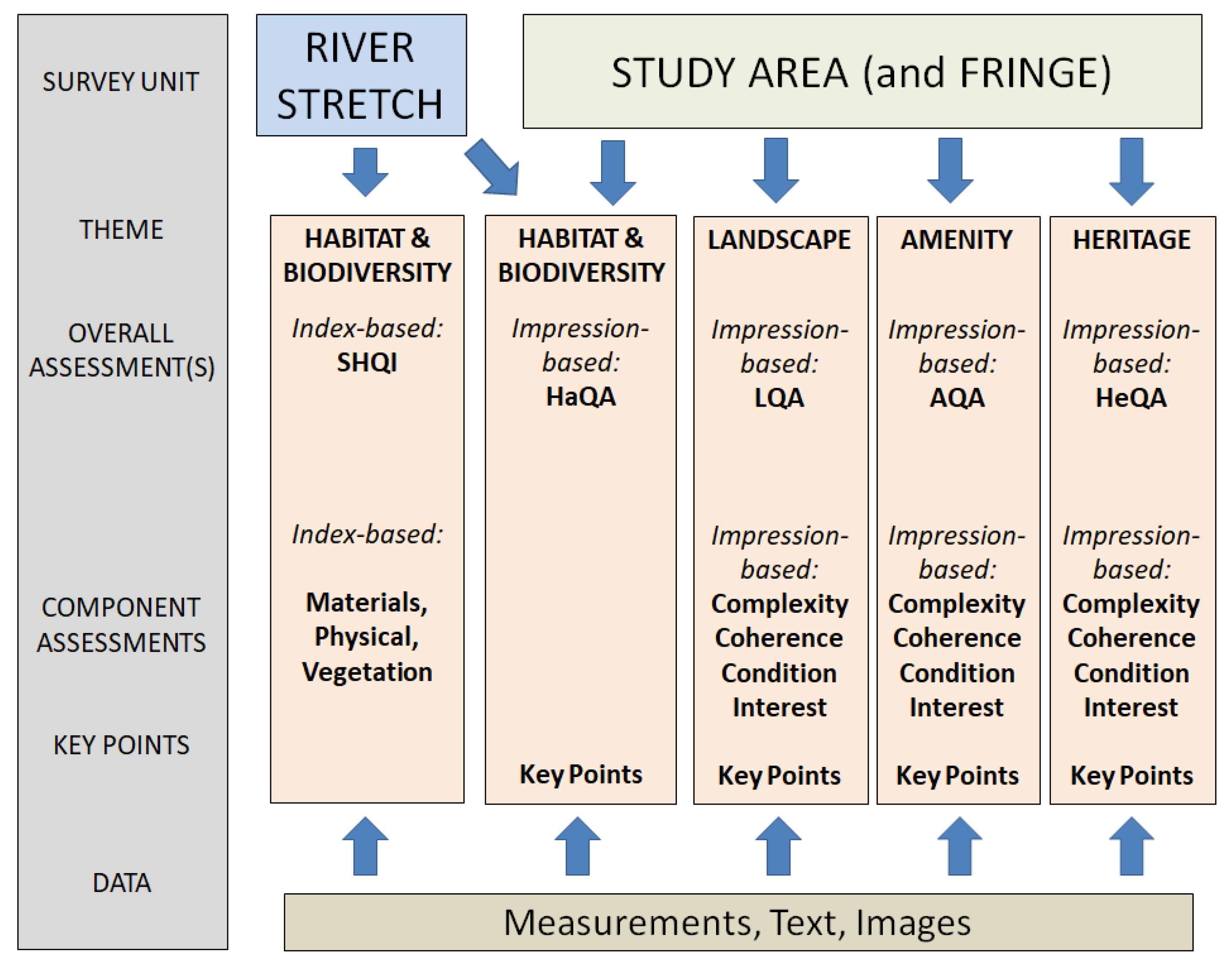
| Measurements: Quantitative and semi-quantitative measurements are recorded on a 4-page River Survey form, supported by two code sheets and a 3-page Study Area form. |
| Indices and Index-based Assessments: These are calculated automatically once the field survey measurements have been entered into the online system, checked, and approved. |
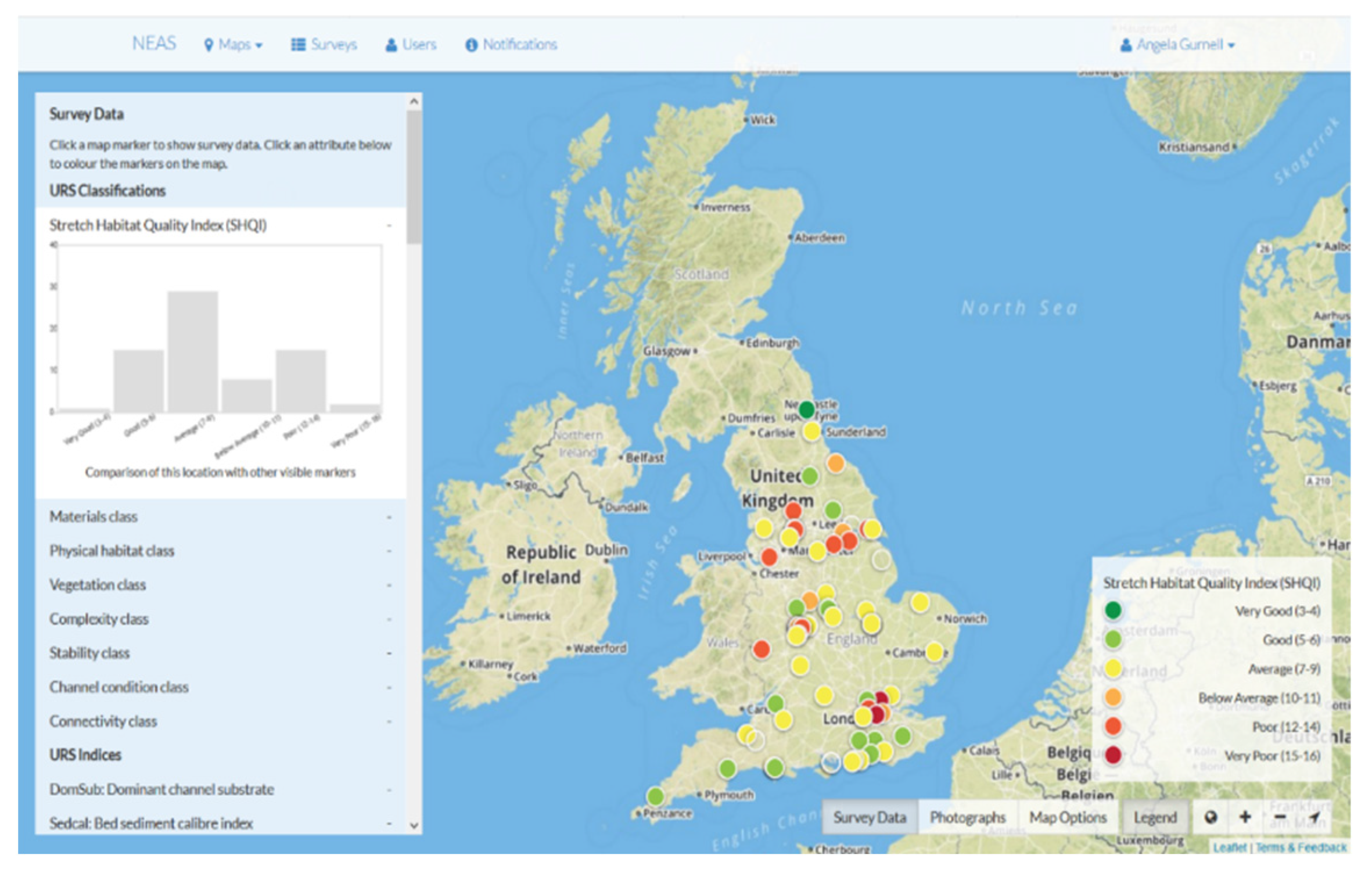
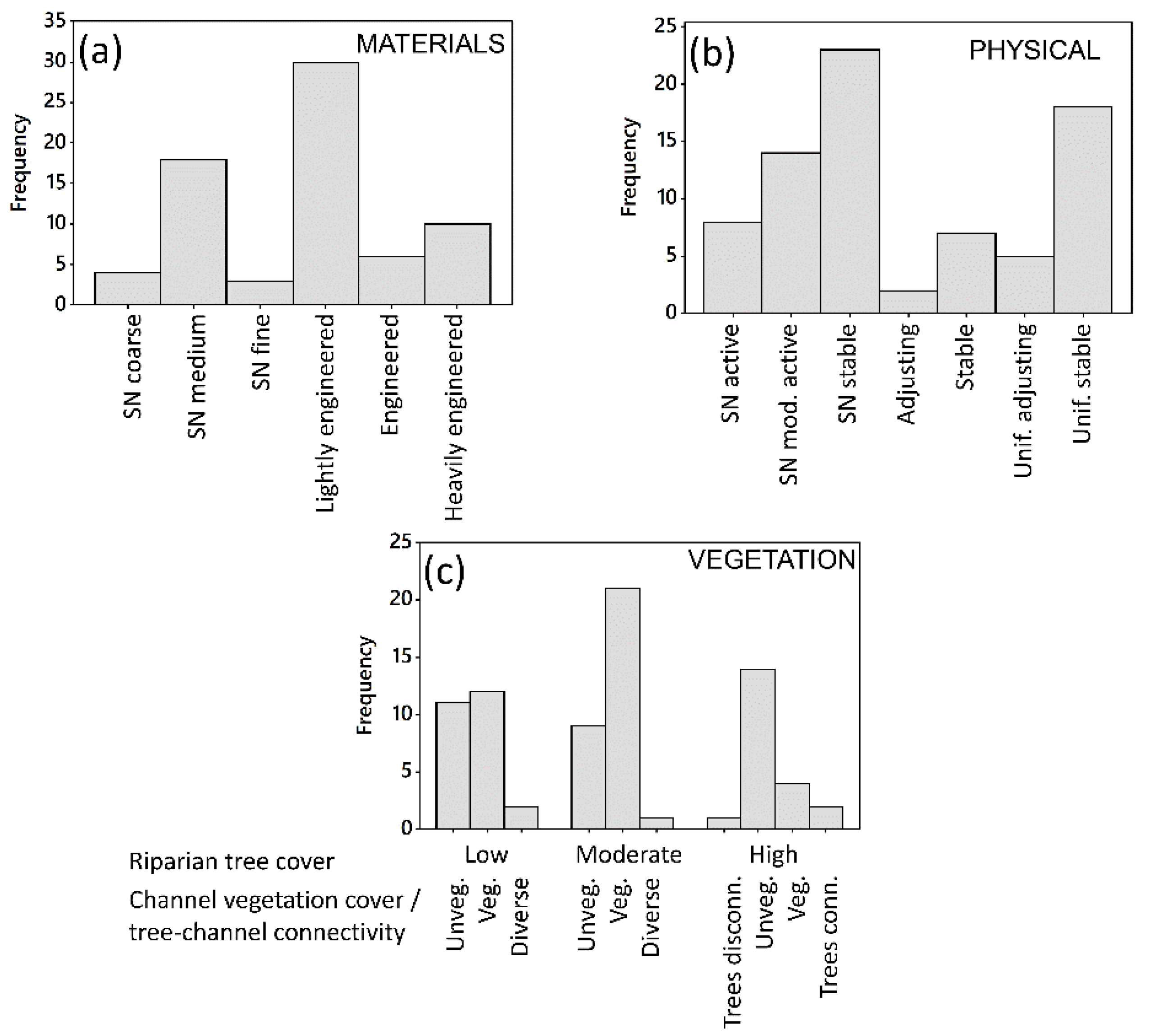
| River Survey Indices (n = 70): These are derived from River Survey measurements (based on indices used in the Urban River Survey) to describe the following characteristics of the river and its margins: sediment calibre; flow types; bar types; bank profile types; vegetation; bank protection; pollution and nuisance plant species; channel stability; channel adjustment (refer to Supplementary Information (2) Table S1 pp. 3–13 for full details). Based on these indices, surveyed river stretches are classified according to their Materials, Physical Habitat, and Vegetation [27]. The Stretch Habitat Quality Index (SHQI) is derived from these three component classifications and supports the evaluation of Habitat and Biodiversity. SHQI values range from 3 to 16 with the lowest scores representing the highest-quality stretches. |
| Study Area Indices (n = 20): These are derived from measurements of the Study Area to describe characteristics, including: land cover; human accessibility and connectivity; recreation; education facilities; health and safety; economic and social value (refer to Supplementary Information (2) Table S2 pp. 14–17 for full details). |
| Key Points: These record the impressions gained by the surveyor while walking the whole site to complete the River and Study Area Surveys and are assembled in the field after completing the River and Study Area forms. They include summary points, ideally accompanied by images (e.g., photographs, maps, documents, annotated field sketches) and accurate locations of features of importance at the time of the survey. See for example Supplementary Information (3). Key points are crucial in supporting the high-level impression-based assessments of Habitat, Landscape, Amenity, and Heritage. |
| Impression-based Assessments: These reflect the surveyor’s overview of the “quality” of the Study Area and its river and generate four impression-based assessments: Habitat Quality Assessment (HaQA,; Landscape Quality Assessment (LQA), Amenity Quality Assessment (AQA), and Heritage Quality Assessment (HeQA). The assessments are recorded in the field on four forms, each with a guidance sheet. A single score is assigned and based on a 5-point scale, where 1 represents Very Good or optimum quality for the site, 2 Good, 3 Average, 4 Poor, and 5 Very Poor. Assessments of the Complexity, Coherence, Interest, and Condition, also recorded on a 5-point scale, a measure of the Level of Confidence of the surveyor (High, Medium, Low), and the Key Points all support the single high-level impression-based assessments of Landscape, Amenity, and Heritage. Refer to Supplementary Information (1) Technical Manual for full descriptions of the impression-based assessments and assignment of scores. |
| Sediment Calibre Indices | Bank Protection Indices |
|---|---|
| Dominant Channel Substrate Type Bed Sediment Calibre Index Dominant Bank Material Type Bank Sediment Calibre Index Number of Mineral Bed Sediment Classes | Dominant Bank Material Protection Type Dominant Bank Protection Class Number Bank Protection Types Proportion Biodegradable Bank Protection Proportion Open Matrix Bank Protection Proportion Solid Bank Protection Proportion Immobile Bank Materials Proportion Immobile Substrate |
| Flow Type Indices | Pollution and Nuisance Plant Species Indices |
| Dominant Flow Types Number of Flow Types Number of Flow Habitats Proportion of Pools Proportion of Marginal Dead Water Proportion of Glides Proportion of Riffles Proportion of Runs | Number of Pollution Indicators Extent of Trash and Gross Pollution Number of Nuisance Plant Species Extent of Nuisance Plant Species Severity of invasion by Nuisance Plant Species Number of Input Pipes Number of Leach Points Number of Input and Leach Points Potential River Pollution Intensity |
| Bar Type Indices | Channel Stability Indices |
| Count of Vegetated Side Bars Count of Unvegetated Side Bars Count of Sand/Silt Deposits Count of Unvegetated and Vegetated Mid-channel Bar Count of Unvegetated and Vegetated Point Bars Number of Bar Types | Heavily Vegetated Banks and Bars Negligible bank erosion Extensive Mature Trees along Banks Stable Channel |
| Bank Profile Type Indices | Channel Adjustment Indices |
| Dominant Natural Bank Profile Type Number of Natural Bank Profile Types Number of Natural Bank Habitats Dominant Artificial Bank Profile Type Number of Artificial Bank Profile Types Proportion Natural Bank Profiles Proportion No Bank Protection Proportion Artificial Bank Profiles | Evidence for Lateral Migration Evidence for Channel Widening Evidence for Channel Narrowing Potential Channel Bed Incision Evidence for Bed and/or Bank Aggradation |
| Vegetation Indices | Other |
| Average Channel Vegetation Cover Number of Channel Vegetation Types Dominant Channel Vegetation Type Count of Tree Features Complexity Bank Face Structure Complexity Bank Top Structure Complexity Tree Cover Number of Vegetation Habitats | Number of River and Margin Habitats Extent of Disruption of Longitudinal Continuity by In-channel Structures Number of Special Features |
Land Cover Indices
|
| SHQI Values | SHQI Categories | Characteristics | Management Recommendations |
|---|---|---|---|
| 3–4 | Very Good | Predominantly semi-natural stretches or those that are recovering strongly from past interventions. Well-developed riparian vegetation, tree cover, and in some cases, diverse channel vegetation. | Leave these stretches free of management and protect them from development. |
| 5–6 | Good | Semi-natural, recovering, and a few uniform channels displaying some activity, with good vegetation complexity and tree cover. | Remove any remaining reinforcement to allow the channel to recover more freely and protect it from further development. |
| 7–9 | Average | Stretches with varying levels of engineering, but displaying some level of either recovery or activity, with reduced riparian vegetation complexity. | Target for rehabilitation opportunities. Where possible, reduce the levels of immobile substrates and bank materials and increase sinuosity. Tree cover and bank top and face vegetation should be managed to provide increased variety and complexity. |
| 10–11 | Below Average | Stretches with varying levels of modification, but showing high levels of activity, combined with low bank vegetation complexity, and often, channels are choked with macrophytes. | Target for rehabilitation opportunities. Where possible, reduce or alter the level and/or type of reinforcement and increase channel sinuosity where possible. Where macrophyte cover is excessive, increase tree cover through planting to provide partial shade and/or narrow the channel to increase shear stresses. |
| 12–14 | Poor | Moderate to heavily engineered channels with low to moderate levels of activity, low complexity of bank vegetation, and often, algal-dominated channels. | Assess the water quality for improvement of in-channel vegetation diversity and assess the level of rehabilitation required to improve the physical condition of the channel. Where possible, reduce the level and/or type of reinforcement and increase channel sinuosity. |
| 15–16 | Very Poor | Heavily engineered, often algal-dominated, stable channels with little vegetation complexity. | Improve water quality and undertake aesthetic rehabilitation in the short term followed by some reduction in the level of reinforcement and an increase in channel sinuosity where possible. |
Publisher’s Note: MDPI stays neutral with regard to jurisdictional claims in published maps and institutional affiliations. |
© 2022 by the authors. Licensee MDPI, Basel, Switzerland. This article is an open access article distributed under the terms and conditions of the Creative Commons Attribution (CC BY) license (https://creativecommons.org/licenses/by/4.0/).
Share and Cite
Wharton, G.; Gurnell, A.M.; Ross, M.; Pereira-Gurnell, D. The PlaceMarker Survey: A Place-Based Tool for Supporting the Monitoring and Appraisal of River-Related Projects and Natural Capital Assessments. Water 2022, 14, 2514. https://doi.org/10.3390/w14162514
Wharton G, Gurnell AM, Ross M, Pereira-Gurnell D. The PlaceMarker Survey: A Place-Based Tool for Supporting the Monitoring and Appraisal of River-Related Projects and Natural Capital Assessments. Water. 2022; 14(16):2514. https://doi.org/10.3390/w14162514
Chicago/Turabian StyleWharton, Geraldene, Angela M. Gurnell, Mark Ross, and Dave Pereira-Gurnell. 2022. "The PlaceMarker Survey: A Place-Based Tool for Supporting the Monitoring and Appraisal of River-Related Projects and Natural Capital Assessments" Water 14, no. 16: 2514. https://doi.org/10.3390/w14162514


