
Evaluating Impacts of Detailed Land Use and Management Inputs on the Accuracy and Resolution of SWAT Predictions in an Experimental Watershed


Abstract
:1. Introduction
2. Materials and Methods
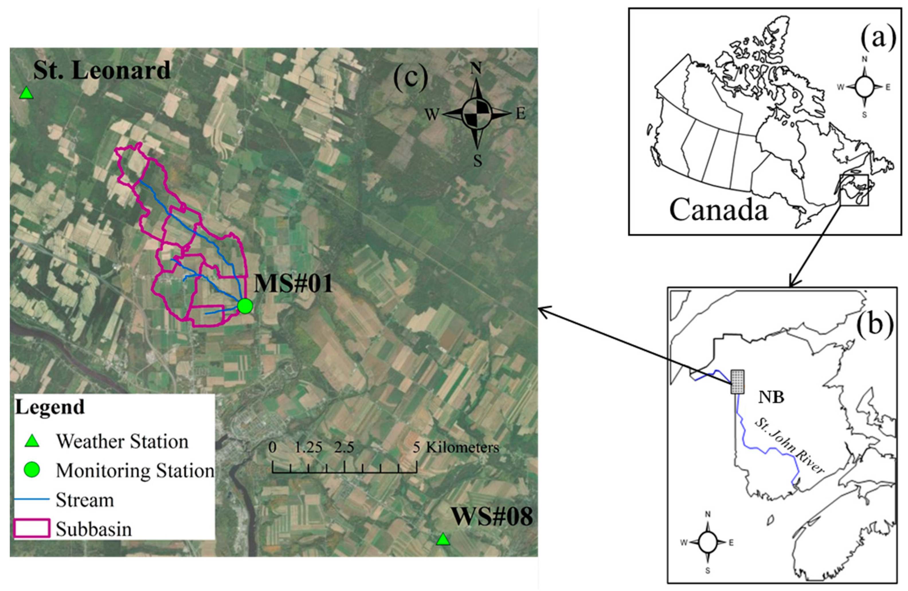
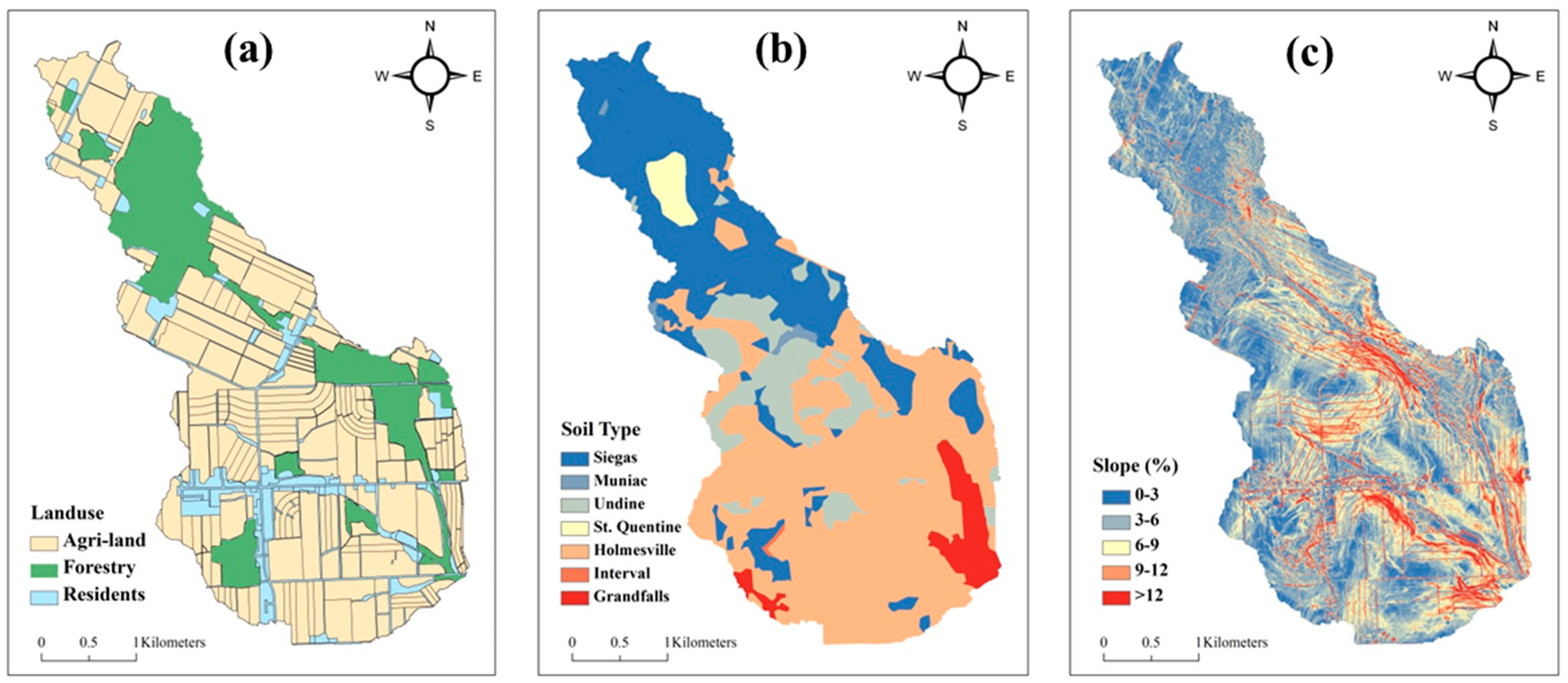
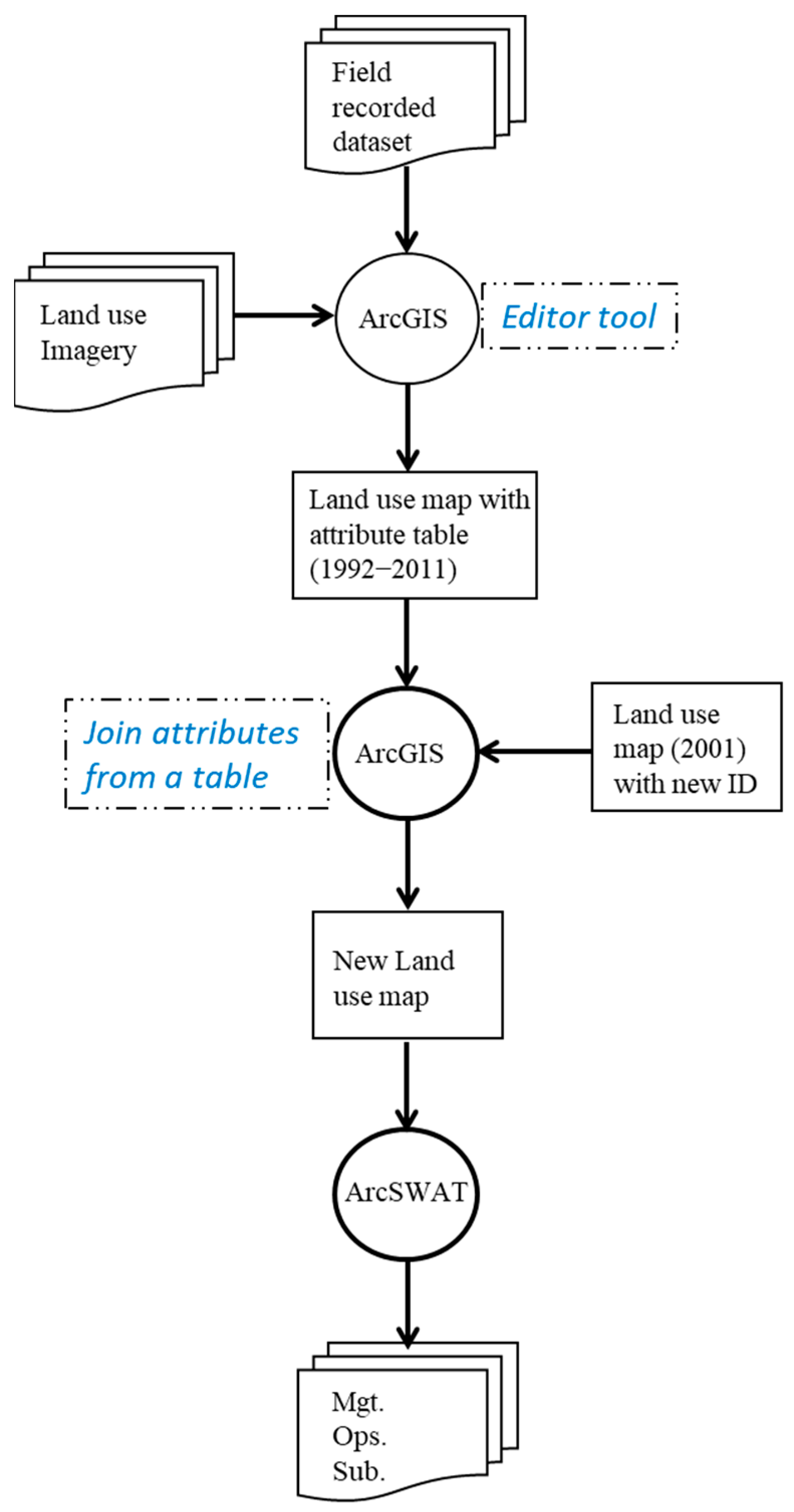
2.1. Study Site and Data Collection
2.2. SWAT Setup
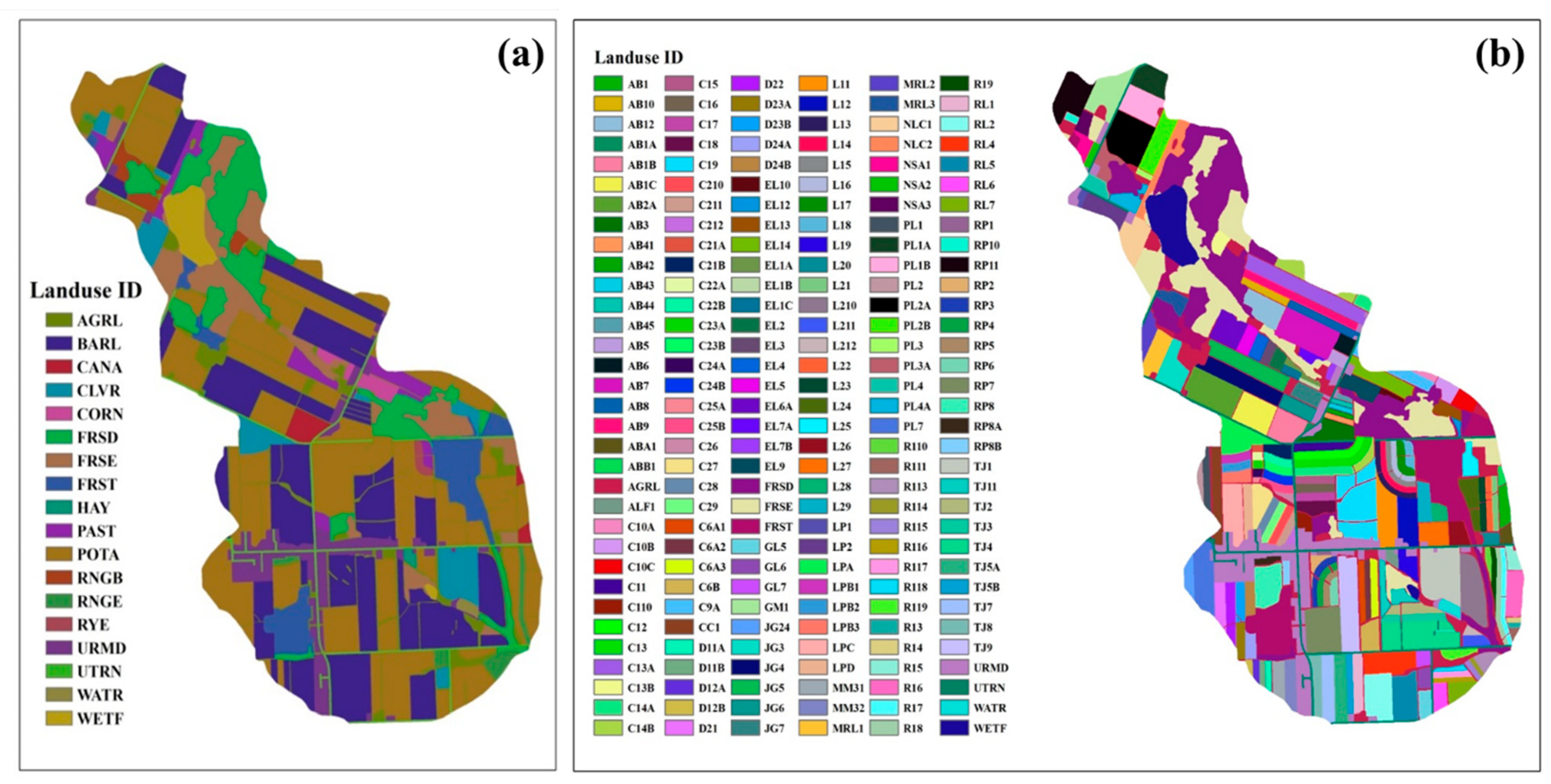
2.2.1. New Land Use Map
2.2.2. Management Data Configuration
- (1)
- Potato–barley was assigned to land use ID POTA. For other land use IDs, it was assumed that no crop rotation took place;
- (2)
- Fertilizers were applied only to potato and barley, and fertilizer amounts and N/P ratios were averaged over the entire watershed based on 2001 survey data from the BBW;
- (3)
- Contour tillage was applied only to potato and barley fields, and tillage areas were proportionally assigned to potato and barley fields over the entire watershed based on 2001 survey data from the BBW; and
- (4)
- FDT and grassed waterways were applied only to potato and barley fields, and their areas were proportionally assigned to potato and barley fields in individual subbasins based on 2001 survey data from the BBW.
2.3. SWAT Calibration and Validation
2.4. Statistical Evaluation
3. Results and Discussion
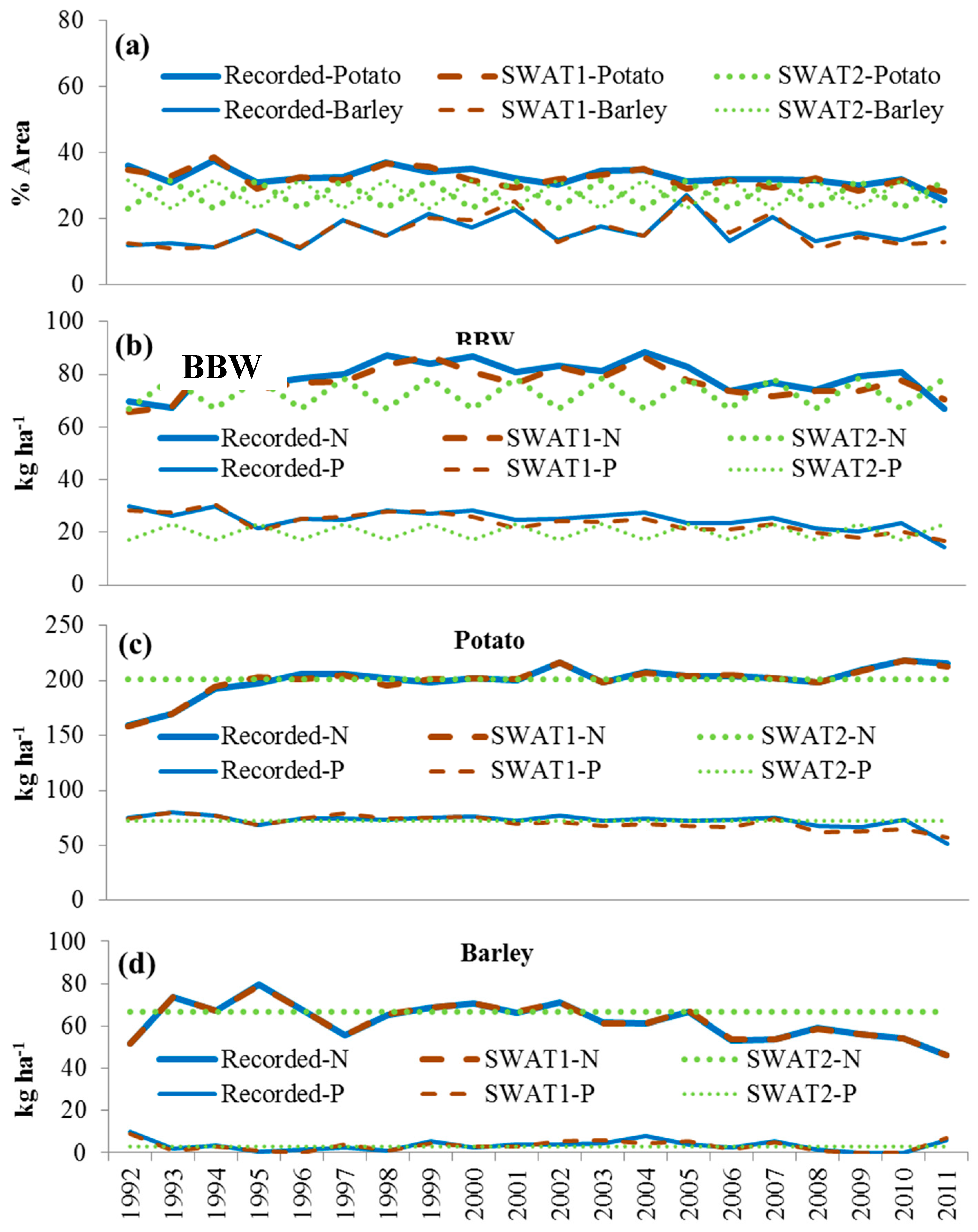
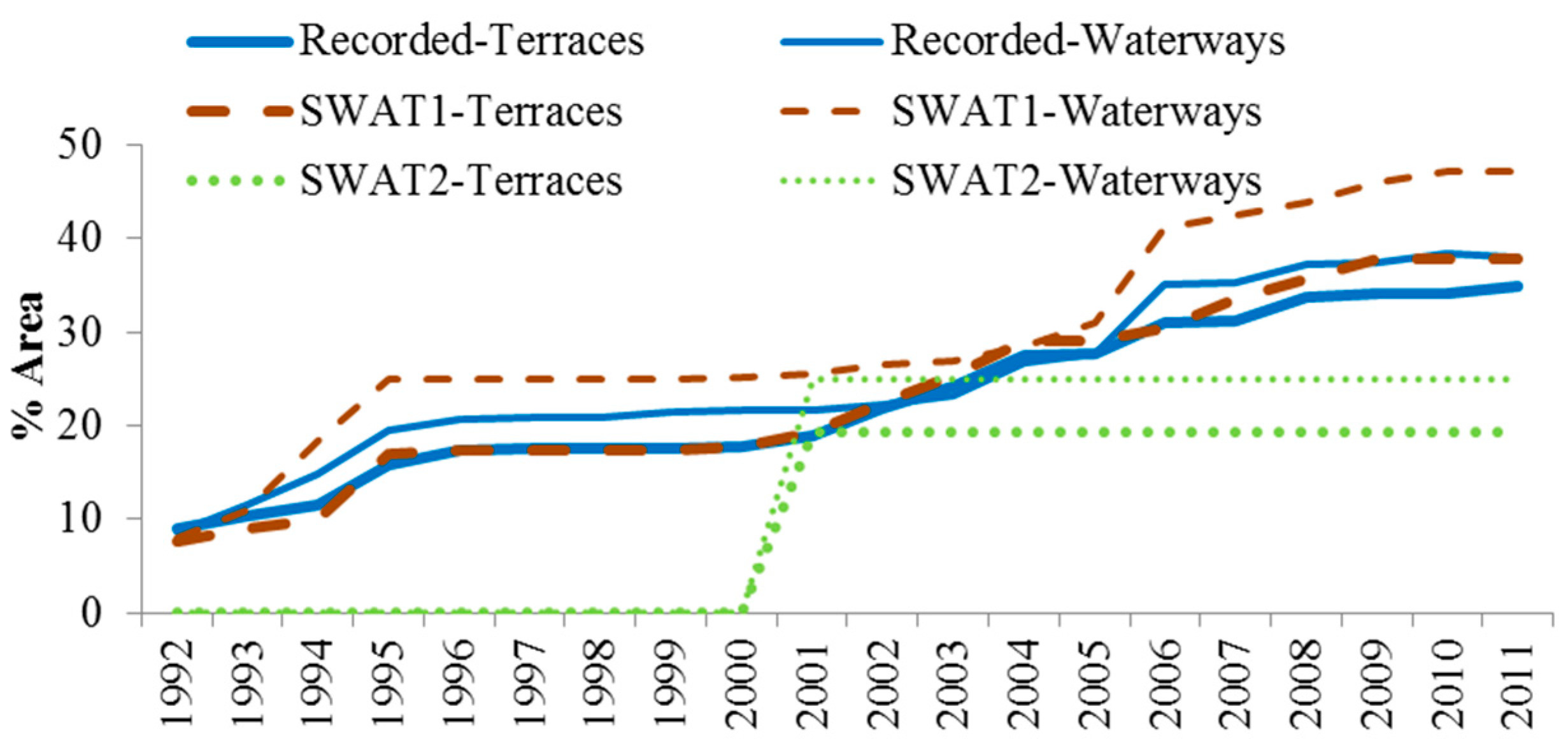
3.1. Input Resolutions of Land Use and Management Practices
3.1.1. Crop Rotation, Fertilizer Application, and Contour Tillage
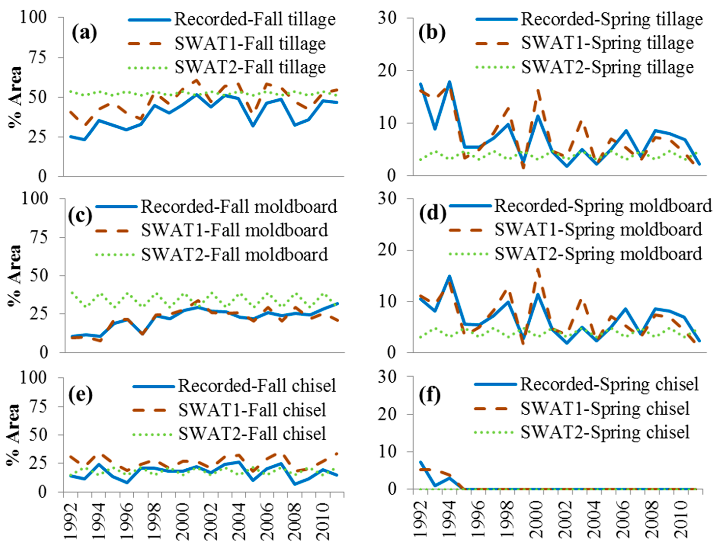
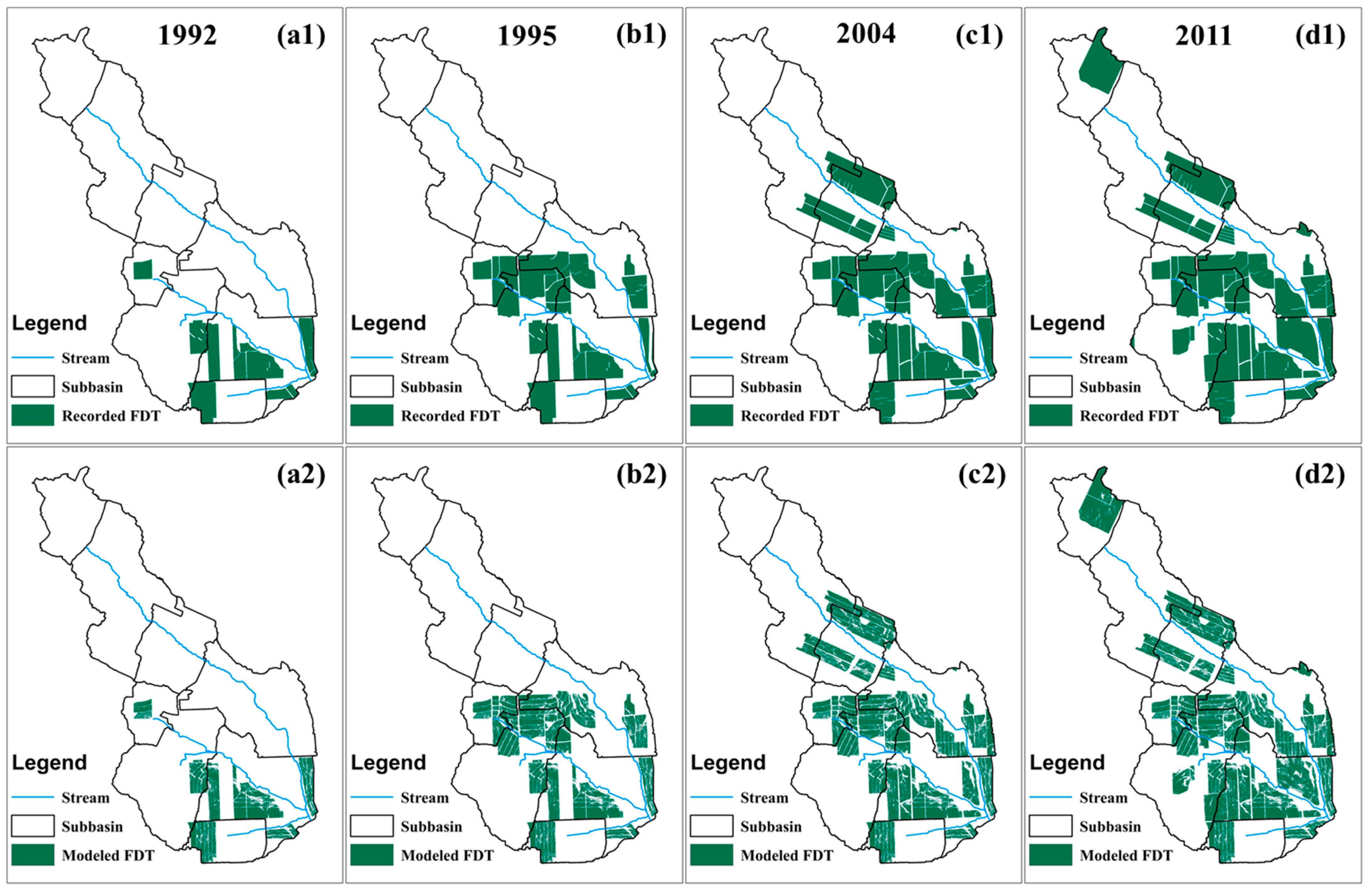
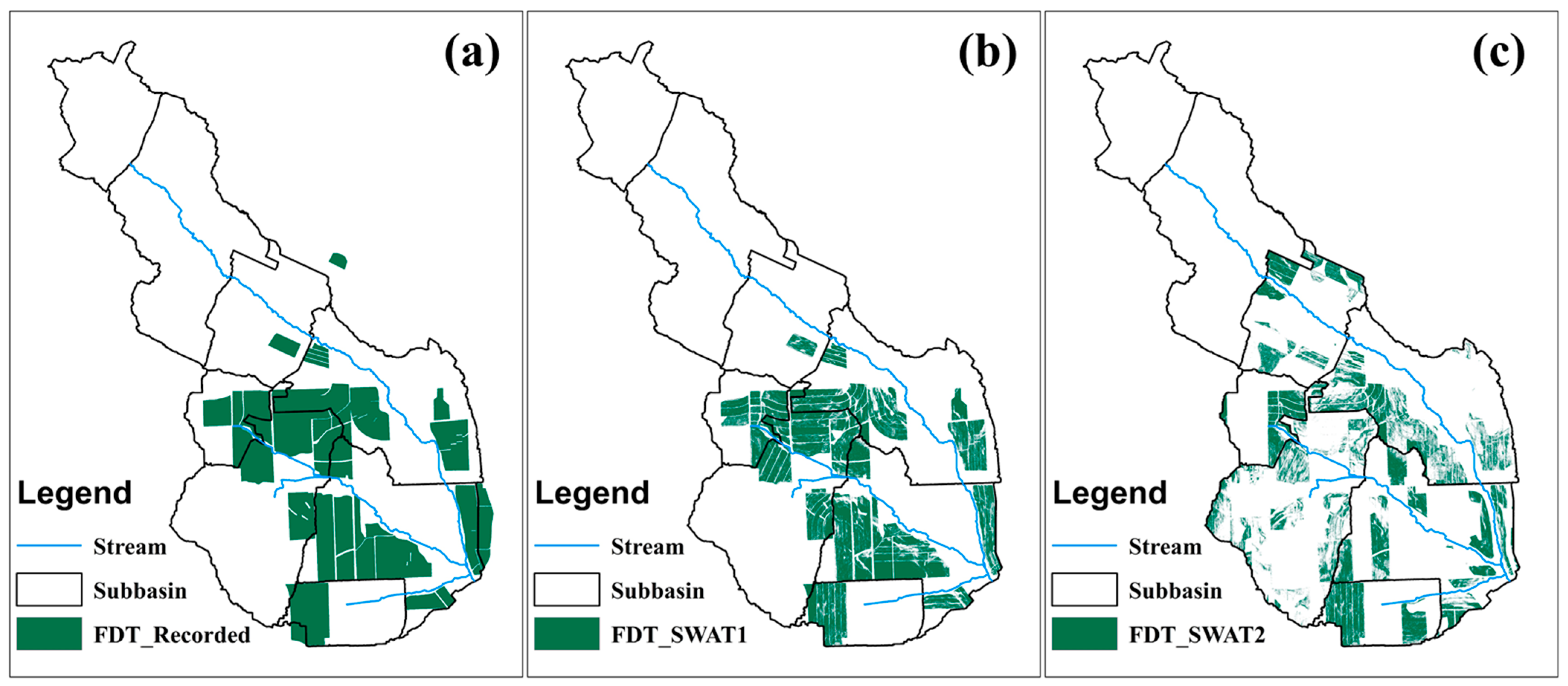
3.1.2. Terraces and Grassed Waterways
3.2. SWAT Calibration
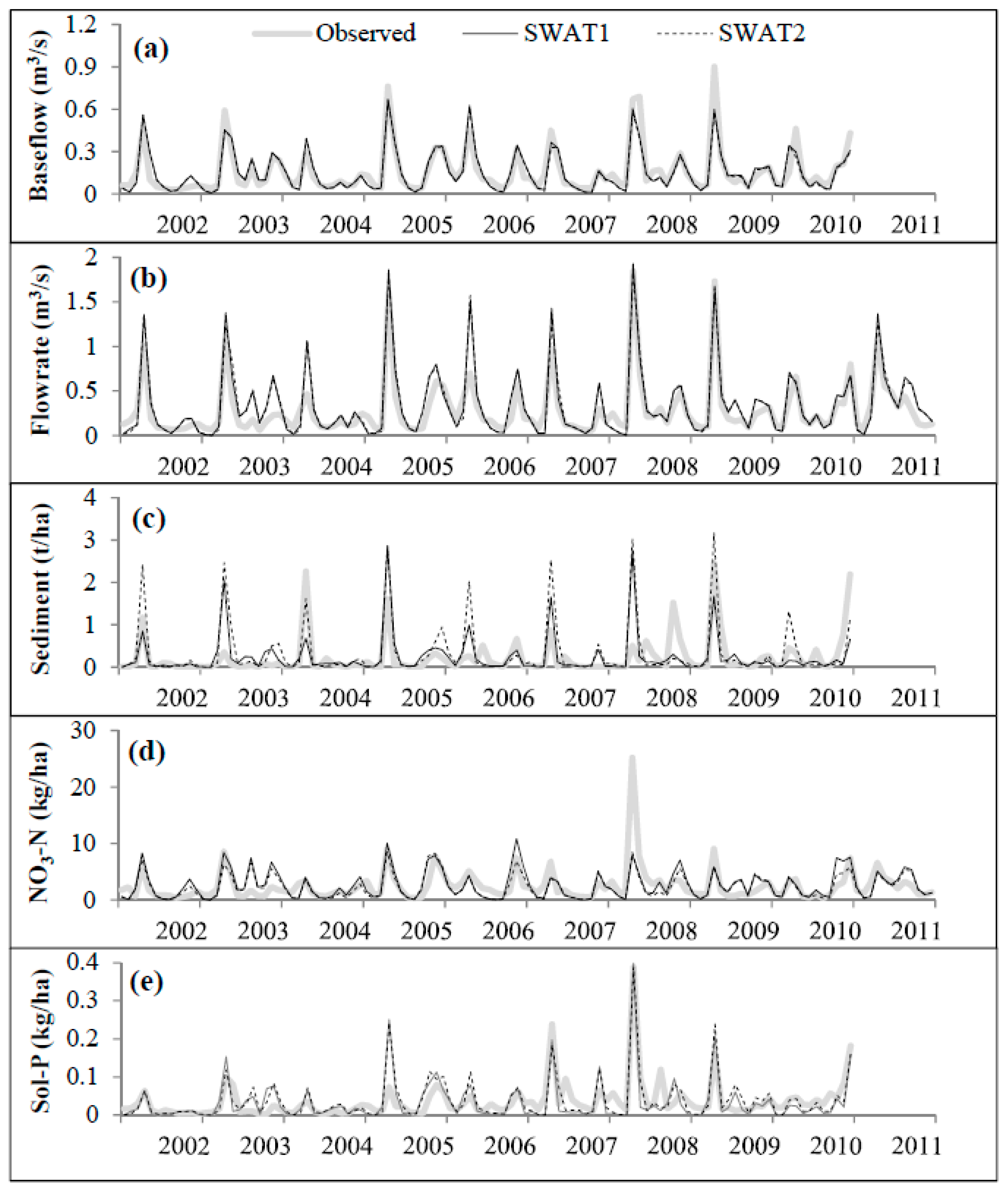
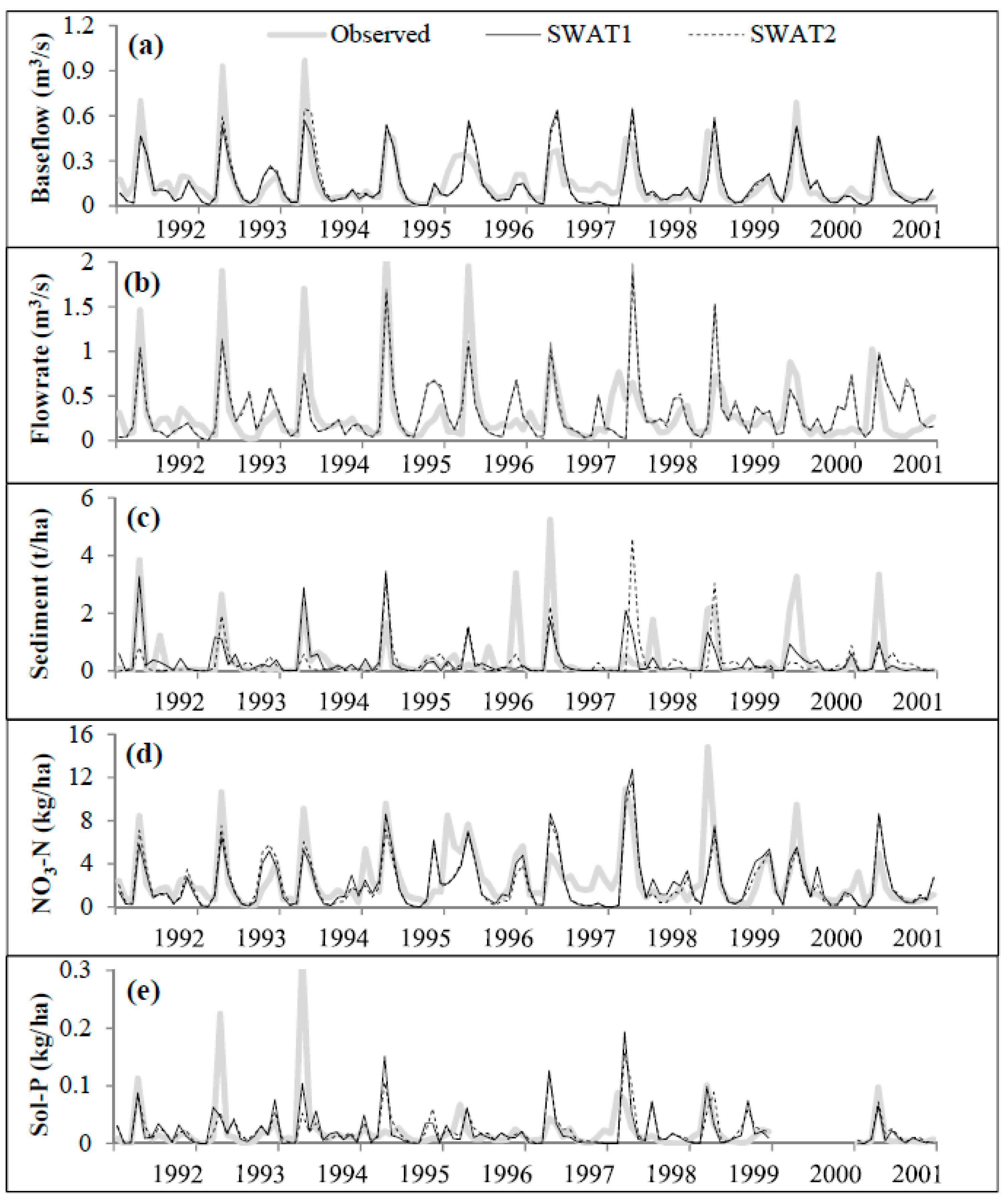
3.3. Impacts on Monthly Water Flow and Sediment and Nutrient Loadings
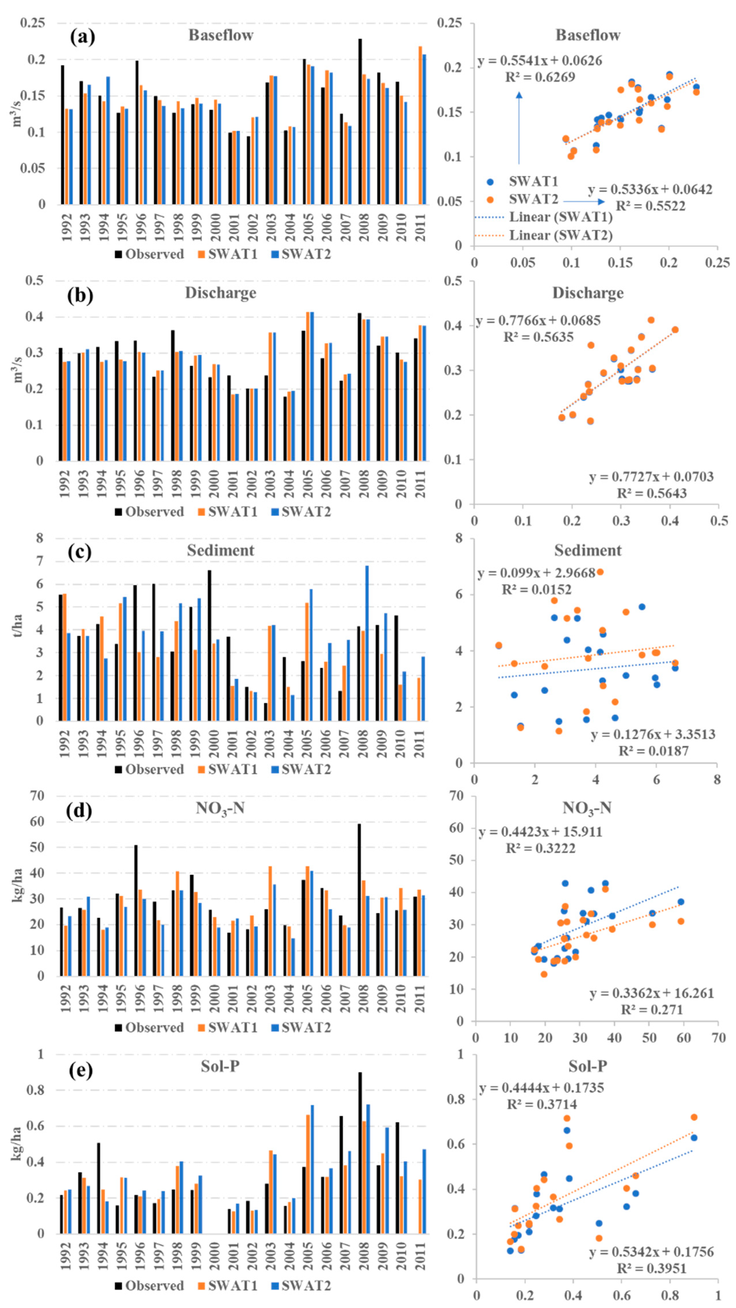
3.4. Impacts on Annual Stream Flow and Sediment and Nutrient Loadings
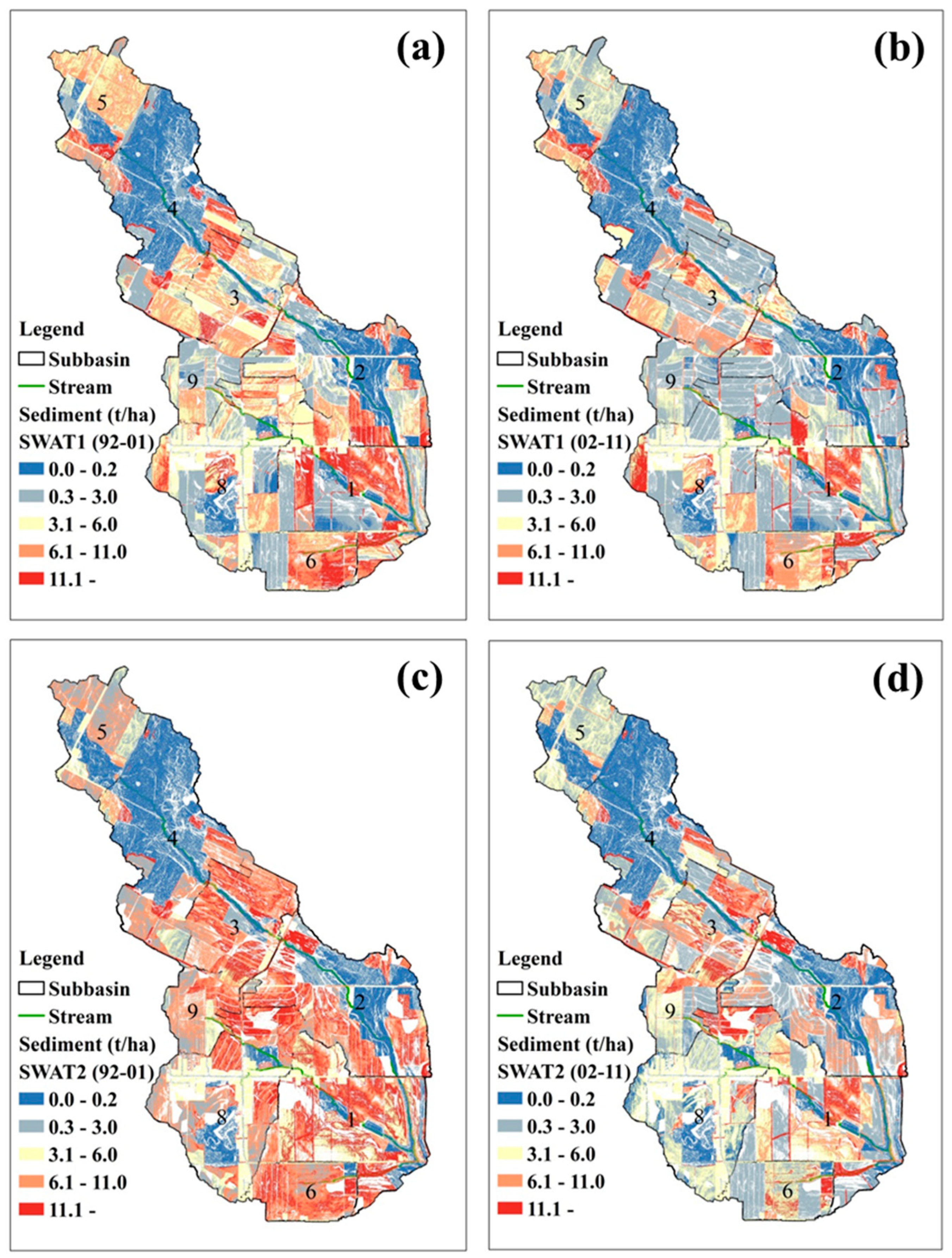
3.5. Spatial Impact of FDT on Soil Erosion
4. Comparing with Other Studies
5. Conclusions
Author Contributions
Funding
Institutional Review Board Statement
Informed Consent Statement
Data Availability Statement
Conflicts of Interest
References
- Singh, V.P.; Frevert, D.K. Watershed Models; CRC Press: Boca Raton, FL, USA, 2005. [Google Scholar]
- Junyu, Q.; Liying, S.; Qiangguo, C. Zonal differences of runoff and sediment reduction effects for typical management small watersheds in China. Int. Soil Water Conserv. Res. 2013, 1, 39–48. [Google Scholar] [CrossRef] [Green Version]
- Sharpley, A.N.; Williams, J.R. EPIC-Erosion/Productivity Impact Calculator: 1. Model Documentation; Technical Bulletin-United States Department of Agriculture: Washington, DC, USA, 1990. [Google Scholar]
- Laflen, J.M.; Lane, L.J.; Foster, G.R. WEPP: A new generation of erosion prediction technology. J. Soil Water Conserv. 1991, 46, 34–38. [Google Scholar]
- Graham, D.N.; Butts, M.B. Flexible, integrated watershed modelling with MIKE SHE. Watershed Models 2005, 849336090, 245–272. [Google Scholar]
- Beasley, D.; Huggins, L.; Monke, A. ANSWERS: A model for watershed planning. Trans. ASAE 1980, 23, 938–944. [Google Scholar] [CrossRef]
- Young, R.A.; Onstad, C.; Bosch, D.; Anderson, W. AGNPS: A nonpoint-source pollution model for evaluating agricultural watersheds. J. Soil Water Conser. 1989, 44, 168–173. [Google Scholar]
- Hundecha, Y.; Bárdossy, A. Modeling of the effect of land use changes on the runoff generation of a river basin through parameter regionalization of a watershed model. J. Hydrol. 2004, 292, 281–295. [Google Scholar] [CrossRef]
- Manguerra, H.; Engel, B. Hydrological Parameterization of Watersheds for Runoff Prediction Using SWAT. JAWRA J. Am. Water Resour. Assoc. 1998, 34, 1149–1162. [Google Scholar] [CrossRef]
- Beven, K. Changing ideas in hydrology—The case of physically-based models. J. Hydrol. 1989, 105, 157–172. [Google Scholar] [CrossRef]
- Goulden, T.; Jamieson, R.; Hopkinson, C.; Sterling, S.; Sinclair, A.; Hebb, D. Sensitivity of hydrological outputs from SWAT to DEM spatial resolution. Photogramm. Eng. Remote Sens. 2014, 80, 639–652. [Google Scholar] [CrossRef]
- Kalcic, M.M.; Chaubey, I.; Frankenberger, J. Defining Soil and Water Assessment Tool (SWAT) hydrologic response units (HRUs) by field boundaries. Int. J. Agric. Biol. Eng. 2015, 8, 69–80. [Google Scholar]
- Ahiablame, L.; Sinha, T.; Paul, M.; Ji, J.-H.; Rajib, A. Streamflow response to potential land use and climate changes in the James River watershed, Upper Midwest United States. J. Hydrol. Reg. Stud. 2017, 14, 150–166. [Google Scholar] [CrossRef]
- Jha, M.; Gassman, P.W.; Secchi, S.; Gu, R.; Arnold, J. Effect of Watershed Subdivision on Swat Flow, Sediment, and Nutrient Predictions. JAWRA J. Am. Water Resour. Assoc. 2004, 40, 811–825. [Google Scholar] [CrossRef] [Green Version]
- Arnold, J.G.; Srinivasan, R.; Muttiah, R.S.; Williams, J.R. Large area hydrologic modeling and assessment part I: Model development. JAWRA J. Am. Water Resour. Assoc. 1998, 34, 73–89. [Google Scholar] [CrossRef]
- Gassman, P.W.; Reyes, M.R.; Green, C.H.; Arnold, J.G. SWAT peer-reviewed literature: A review. In Proceedings of the 3rd International SWAT Conference, Zurich, Switzerland, 11–15 July 2005. [Google Scholar]
- Ullrich, A.; Volk, M. Application of the Soil and Water Assessment Tool (SWAT) to predict the impact of alternative management practices on water quality and quantity. Agric. Water Manag. 2009, 96, 1207–1217. [Google Scholar] [CrossRef]
- Qi, J.; Li, S.; Bourque, C.P.; Xing, Z.; Meng, F.R. Developing a decision support tool for assessing land use change and BMPs in ungauged watersheds based on decision rules provided by SWAT simulation. Hydrol. Earth Syst. Sci. 2018, 22, 3789–3806. [Google Scholar] [CrossRef] [Green Version]
- Qi, J.; Li, S.; Jamieson, R.; Hebb, D.; Xing, Z.; Meng, F.-R. Modifying SWAT with an energy balance module to simulate snowmelt for maritime regions. Environ. Model. Softw. 2017, 93, 146–160. [Google Scholar] [CrossRef]
- Qi, J.; Li, S.; Li, Q.; Xing, Z.; Bourque, C.P.-A.; Meng, F.-R. A new soil-temperature module for SWAT application in regions with seasonal snow cover. J. Hydrol. 2016, 538, 863–877. [Google Scholar] [CrossRef]
- Wang, Q.; Qi, J.; Li, J.; Cole, J.; Waldhoff, S.T.; Zhang, X. Nitrate loading projection is sensitive to freeze-thaw cycle representation. Water Res. 2020, 186, 116355. [Google Scholar] [CrossRef]
- Wang, Q.; Qi, J.; Wu, H.; Zeng, Y.; Shui, W.; Zeng, J.; Zhang, X. Freeze-Thaw cycle representation alters response of watershed hydrology to future climate change. Catena 2020, 195, 104767. [Google Scholar] [CrossRef]
- Abbaspour, K.C.; Rouholahnejad, E.; Vaghefi, S.; Srinivasan, R.; Yang, H.; Kløve, B. A continental-scale hydrology and water quality model for Europe: Calibration and uncertainty of a high-resolution large-scale SWAT model. J. Hydrol. 2015, 524, 733–752. [Google Scholar] [CrossRef] [Green Version]
- Akoko, G.; Le, T.H.; Gomi, T.; Kato, T. A review of SWAT model application in Africa. Water 2021, 13, 1313. [Google Scholar] [CrossRef]
- Li, Q.; Qi, J.; Xing, Z.; Li, S.; Jiang, Y.; Danielescu, S.; Zhu, H.; Wei, X.; Meng, F.-R. An approach for assessing impact of land use and biophysical conditions across landscape on recharge rate and nitrogen loading of groundwater. Agric. Ecosyst. Environ. 2014, 196, 114–124. [Google Scholar] [CrossRef]
- Yang, Q.; Meng, F.-R.; Zhao, Z.; Chow, T.L.; Benoy, G.; Rees, H.W.; Bourque, C.P.-A. Assessing the impacts of flow diversion terraces on stream water and sediment yields at a watershed level using SWAT model. Agric. Ecosyst. Environ. 2009, 132, 23–31. [Google Scholar] [CrossRef]
- Gassman, P.W.; Reyes, M.R.; Green, C.H.; Arnold, J.G. The soil and water assessment tool: Historical development, applications, and future research directions. Trans. ASABE 2007, 50, 1211–1250. [Google Scholar] [CrossRef] [Green Version]
- Ning, J.; Gao, Z.; Lu, Q. Runoff simulation using a modified SWAT model with spatially continuous HRUs. Environ. Earth Sci. 2015, 74, 5895–5905. [Google Scholar] [CrossRef]
- Chow, T.; Rees, H. Impacts of Intensive Potato Production on Water Yield and Sediment Load (Black Brook Experimental Watershed: 1992–2002 Summary); Potato Research Centre, AAFC: Fredericton, NB, Canada, 2006; p. 26. [Google Scholar]
- Zhao, Z.; Chow, T.L.; Yang, Q.; Rees, H.W.; Benoy, G.; Xing, Z.; Meng, F.-R. Model prediction of soil drainage classes based on digital elevation model parameters and soil attributes from coarse resolution soil maps. Can. J. Soil Sci. 2008, 88, 787–799. [Google Scholar] [CrossRef]
- Mellerowicz, K.T. Soils of the Black Brook Watershed St. Andre Parish, Madawaska County; New Brunswick Department of Agriculture: Fredericton, NB, Canada, 1993. [Google Scholar]
- Chow, L.; Xing, Z.; Benoy, G.; Rees, H.; Meng, F.; Jiang, Y.; Daigle, J. Hydrology and water quality across gradients of agricultural intensity in the Little River watershed area, New Brunswick, Canada. J. Soil Water Conserv. 2011, 66, 71–84. [Google Scholar] [CrossRef] [Green Version]
- Zhao, Z.; Benoy, G.; Chow, T.L.; Rees, H.W.; Daigle, J.-L.; Meng, F.-R. Impacts of accuracy and resolution of conventional and LiDAR based DEMs on parameters used in hydrologic modeling. Water Resour. Manag. 2010, 24, 1363–1380. [Google Scholar] [CrossRef]
- Qi, J.; Liang, K.; Li, S.; Wang, L.; Meng, F.-R. Hydrological evaluation of flow diversion terraces using downhill-slope calculation method for high resolution and accuracy DEMs. Sustainability 2018, 10, 2414. [Google Scholar] [CrossRef] [Green Version]
- Yang, Q.; Zhao, Z.; Chow, T.L.; Rees, H.W.; Bourque, C.P.A.; Meng, F.R. Using GIS and a digital elevation model to assess the effectiveness of variable grade flow diversion terraces in reducing soil erosion in northwestern New Brunswick, Canada. Hydrol. Process. 2009, 23, 3271–3280. [Google Scholar] [CrossRef]
- Yang, Q.; Zhao, Z.; Benoy, G.; Chow, T.L.; Rees, H.W.; Bourque, C.P.-A.; Meng, F.-R. A watershed-scale assessment of cost-effectiveness of sediment abatement with flow diversion terraces. J. Environ. Qual. 2010, 39, 220–227. [Google Scholar] [CrossRef] [PubMed]
- Haan, C.T.; Barfield, B.J.; Hayes, J.C. Design Hydrology and Sedimentology for Small Catchments; Academic Press: San Diego, CA, USA, 1994. [Google Scholar]
- Wischmeier, W.H.; Smith, D.D. Predicting Rainfall Erosion Losses-A Guide to Conservation Planning. In Agriculture Handbook; Department of Agriculture: Washington, DC, USA, 1978. [Google Scholar]
- Cronshey, R.; McCuen, R.H.; Miller, N.; Rawls, W.; Robbins, S.; Woodward, D. Urban Hydrology for Small Watersheds; National Resources Conservation Service, USDA: Washington, DC, USA, 1986. [Google Scholar]
- Abbaspour, K.; Vejdani, M.; Haghighat, S. SWAT-CUP Calibration and Uncertainty Programs for SWAT; MODSIM 2007 International Congress on Modelling and Simulation, Modelling and Simulation Society of Australia and New Zealand, Australian National University: Canberra, Australia, 2007. [Google Scholar]
- Zhang, R.; Li, Q.; Chow, T.L.; Li, S.; Danielescu, S. Baseflow separation in a small watershed in New Brunswick, Canada, using a recursive digital filter calibrated with the conductivity mass balance method. Hydrol. Process. 2013, 27, 2659–2665. [Google Scholar] [CrossRef]
- Li, Q.; Xing, Z.; Danielescu, S.; Li, S.; Jiang, Y.; Meng, F.-R. Data requirements for using combined conductivity mass balance and recursive digital filter method to estimate groundwater recharge in a small watershed, New Brunswick, Canada. J. Hydrol. 2014, 511, 658–664. [Google Scholar] [CrossRef]
- Nash, J.; Sutcliffe, J. River flow forecasting through conceptual models part I—A discussion of principles. J. Hydrol. 1970, 10, 282–290. [Google Scholar] [CrossRef]
- Qi, J.; Li, S.; Li, Q.; Xing, Z.; Bourque, C.P.-A.; Meng, F.-R. Assessing an Enhanced Version of SWAT on Water Quantity and Quality Simulation in Regions with Seasonal Snow Cover. Water Resour. Manag. 2016, 1–17. [Google Scholar] [CrossRef]
- Moriasi, D.N.; Arnold, J.G.; Van Liew, M.W.; Bingner, R.L.; Harmel, R.D.; Veith, T.L. Model evaluation guidelines for systematic quantification of accuracy in watershed simulations. Trans. ASABE 2007, 50, 885–900. [Google Scholar] [CrossRef]
- Qiu, H.; Qi, J.; Lee, S.; Moglen, G.E.; McCarty, G.W.; Chen, M.; Zhang, X. Effects of temporal resolution of river routing on hydrologic modeling and aquatic ecosystem health assessment with the SWAT model. Environ. Model. Softw. 2021, 146, 105232. [Google Scholar] [CrossRef]
- Lobb, D.A.; Li, S.; McConkey, B.G. Agriculture and Agri-Food Canada; Soil Erosion: Ottawa, ON, Canada, 2016. [Google Scholar]
- Wang, Q.; Liu, R.; Men, C.; Guo, L.; Miao, Y. Effects of dynamic land use inputs on improvement of SWAT model performance and uncertainty analysis of outputs. J. Hydrol. 2018, 563, 874–886. [Google Scholar] [CrossRef]
- Wagner, P.D.; Bhallamudi, S.M.; Narasimhan, B.; Kumar, S.; Fohrer, N.; Fiener, P. Comparing the effects of dynamic versus static representations of land use change in hydrologic impact assessments. Environ. Model. Softw. 2019, 122, 103987. [Google Scholar] [CrossRef]
- Aghsaei, H.; Dinan, N.M.; Moridi, A.; Asadolahi, Z.; Delavar, M.; Fohrer, N.; Wagner, P.D. Effects of dynamic land use/land cover change on water resources and sediment yield in the Anzali wetland catchment, Gilan, Iran. Sci. Total. Environ. 2020, 712, 136449. [Google Scholar] [CrossRef]
- Tram, V.N.Q.; Somura, H.; Moroizumi, T. The Impacts of Land-Use Input Conditions on Flow and Sediment Discharge in the Dakbla Watershed, Central Highlands of Vietnam. Water 2021, 13, 627. [Google Scholar] [CrossRef]


| Dataset | SWAT1 | SWAT2 | Location | Purposes |
|---|---|---|---|---|
| 1-m resolution LiDAR DEM | 2010 | — | BBW | SWAT setup |
| Soil map | 1993 | — | BBW | SWAT setup |
| Land use maps | 1992–2011 | 2001 | BBW | SWAT setup |
| Precipitation, temperature, relative humidity, and wind speed | 1992–2011 | — | St. Leonard | SWAT setup |
| Solar radiation | 1992–2011 | — | WS#08 | SWAT setup |
| Tillage operation (spring and fall) | 1992–2011 | 2001 | BBW | SWAT setup |
| Fertilizer application | 1992–2011 | 2001 | BBW | SWAT setup |
| Crop rotation | 1992–2011 | 2001 | BBW | SWAT setup |
| Terraces and grassed waterways | 1992–2011 | 2001 | BBW | SWAT setup |
| Discharge, sediment, NO3-N, and Sol-P | 1992–2011 | — | MS#01 | SWAT calibration & validation |
| Subbasin Number | Area (ha) | Fraction of Total Area (%) | HRUs SWAT1 | HRUs SWAT2 | Main Channel Width (m) | Avg. Channel Slope (m m−1) | Main Channel Length (km) | Main Channel Depth (m) |
|---|---|---|---|---|---|---|---|---|
| 1 | 227 | 17.31 | 154 | 49 | 6.1 | 0.018 | 1.53 | 0.4 |
| 2 | 226 | 17.22 | 180 | 57 | 4.2 | 0.009 | 2.80 | 0.3 |
| 3 | 131 | 9.95 | 108 | 50 | 3.3 | 0.008 | 1.32 | 0.2 |
| 4 | 245 | 18.69 | 95 | 45 | 2.8 | 0.007 | 2.21 | 0.2 |
| 5 | 108 | 8.21 | 46 | 25 | 1.4 | 0.005 | 0.02 | 0.1 |
| 6 | 78 | 5.93 | 37 | 17 | 1.1 | 0.018 | 0.68 | 0.1 |
| 8 | 234 | 17.82 | 189 | 41 | 2.5 | 0.017 | 0.96 | 0.2 |
| 9 | 64 | 4.87 | 78 | 26 | 1.0 | 0.029 | 0.46 | 0.1 |
| BMPs | Parameter | Meaning | Initial Value | Calibrated |
|---|---|---|---|---|
| FDT | TERR_P | USLE practice factor | 0.12, slope < 3 | ×(1−0.2) |
| 0.10, 3 < slope < 9 | ||||
| 0.15, 9 < slope | ||||
| TERR_CN | Initial SCS curve number II | 50 | 72 | |
| TERR_SL | Average slope length (m) | 25–100 | 50 for SWAT2 | |
| Grassed waterways | GWATN | Manning’s N value | 0.35 | 0.35 |
| GWATSPCON | Sediment linear parameter | 0.005 | 0.005 | |
| GWATD | Depth of grassed waterway (m) | 3/64 × GWATW | 3/64 × GWATW | |
| GWATW | Mean width of grassed waterway (m) | 5 | 5 | |
| GWATL | Length of grassed waterway (km) | HRU length | HRU length | |
| GWATS | Mean slope of grassed waterways (m) | 0.75 × HRU slope | 0.75 × HRU slope | |
| Contour Tillage | USLE_P | USLE practice factor | 0.5 | 0.6 |
| Relevant Process | Parameter | Unit | Default | Used |
|---|---|---|---|---|
| Snowmelt | Smtmp | °C | 0 | 0.375 |
| Sftmp | °C | 0 | 0.175 | |
| Smfmx | mm °C−1 day−1 | 4.5 | 9.725 | |
| Smfmn | mm °C−1 day−1 | 4.5 | 3.525 | |
| Timp | — | 1 | 0.15 | |
| Baseflow | Alpha_Bf | day−1 | 0.048 | 0.04 |
| Gw_Delay | day | 31 | 1 | |
| Revapmn | mm | 1 | 500 | |
| Rchrg_Dp | — | 0.05 | 0 | |
| Surface and lateral flow | Surlag | — | 4 | 0.075 |
| Esco | — | 0.95 | 0.17 | |
| Epco | — | 1 | 0.93 | |
| Slsoil | m | default | × (1 − 0.5) | |
| NO3-N | Anion_Excl | — | default | × (1 − 0.7) |
| CDN | — | 1.4 | 0.15 | |
| SDNCO | — | 1.1 | 1 | |
| N_Updis | — | 20 | 100 | |
| Sol-P | Phoskd | — | 175 | 110 |
| P_Updis | — | 20 | 25 | |
| PSP | — | 0.7 | 0.7 |
| Period | Model | Index | Base Flow | Discharge | Sediment | NO3-N | Sol-P |
|---|---|---|---|---|---|---|---|
| Ι | SWAT1 | Re (%) | −5.0 | −6.4 | −20.3 | −11.8 | 2.8 |
| R2 | 0.65 | 0.62 | 0.40 | 0.50 | 0.23 | ||
| NS | 0.63 | 0.61 | 0.39 | 0.43 | 0.14 | ||
| SWAT2 | Re (%) | −4.8 | −5.9 | −16.1 | −16.4 | 6.4 | |
| R2 | 0.67 | 0.58 | 0.39 | 0.51 | 0.16 | ||
| NS | 0.65 | 0.58 | 0.39 | 0.46 | 0.09 | ||
| ΙΙ | SWAT1 | Re (%) | −2.5 | 9.2 | 5.6 | 6.1 | −8.7 |
| R2 | 0.82 | 0.89 | 0.30 | 0.40 | 0.65 | ||
| NS | 0.82 | 0.86 | 0.04 | 0.34 | 0.53 | ||
| SWAT2 | Re (%) | −4.8 | 9.2 | 35.9 | −8.2 | 4.3 | |
| R2 | 0.80 | 0.88 | 0.29 | 0.45 | 0.67 | ||
| NS | 0.80 | 0.85 | −0.62 | 0.44 | 0.56 |
Publisher’s Note: MDPI stays neutral with regard to jurisdictional claims in published maps and institutional affiliations. |
© 2022 by the authors. Licensee MDPI, Basel, Switzerland. This article is an open access article distributed under the terms and conditions of the Creative Commons Attribution (CC BY) license (https://creativecommons.org/licenses/by/4.0/).
Share and Cite
Qi, J.; Kang, X.; Li, S.; Meng, F. Evaluating Impacts of Detailed Land Use and Management Inputs on the Accuracy and Resolution of SWAT Predictions in an Experimental Watershed. Water 2022, 14, 2352. https://doi.org/10.3390/w14152352
Qi J, Kang X, Li S, Meng F. Evaluating Impacts of Detailed Land Use and Management Inputs on the Accuracy and Resolution of SWAT Predictions in an Experimental Watershed. Water. 2022; 14(15):2352. https://doi.org/10.3390/w14152352
Chicago/Turabian StyleQi, Junyu, Xiaoyu Kang, Sheng Li, and Fanrui Meng. 2022. "Evaluating Impacts of Detailed Land Use and Management Inputs on the Accuracy and Resolution of SWAT Predictions in an Experimental Watershed" Water 14, no. 15: 2352. https://doi.org/10.3390/w14152352
APA StyleQi, J., Kang, X., Li, S., & Meng, F. (2022). Evaluating Impacts of Detailed Land Use and Management Inputs on the Accuracy and Resolution of SWAT Predictions in an Experimental Watershed. Water, 14(15), 2352. https://doi.org/10.3390/w14152352