
Alpine Wetland Evolution and Their Response to Climate Change in the Yellow-River-Source National Park from 2000 to 2020

 ,
,
Abstract
:1. Introduction
2. Materials and Methods
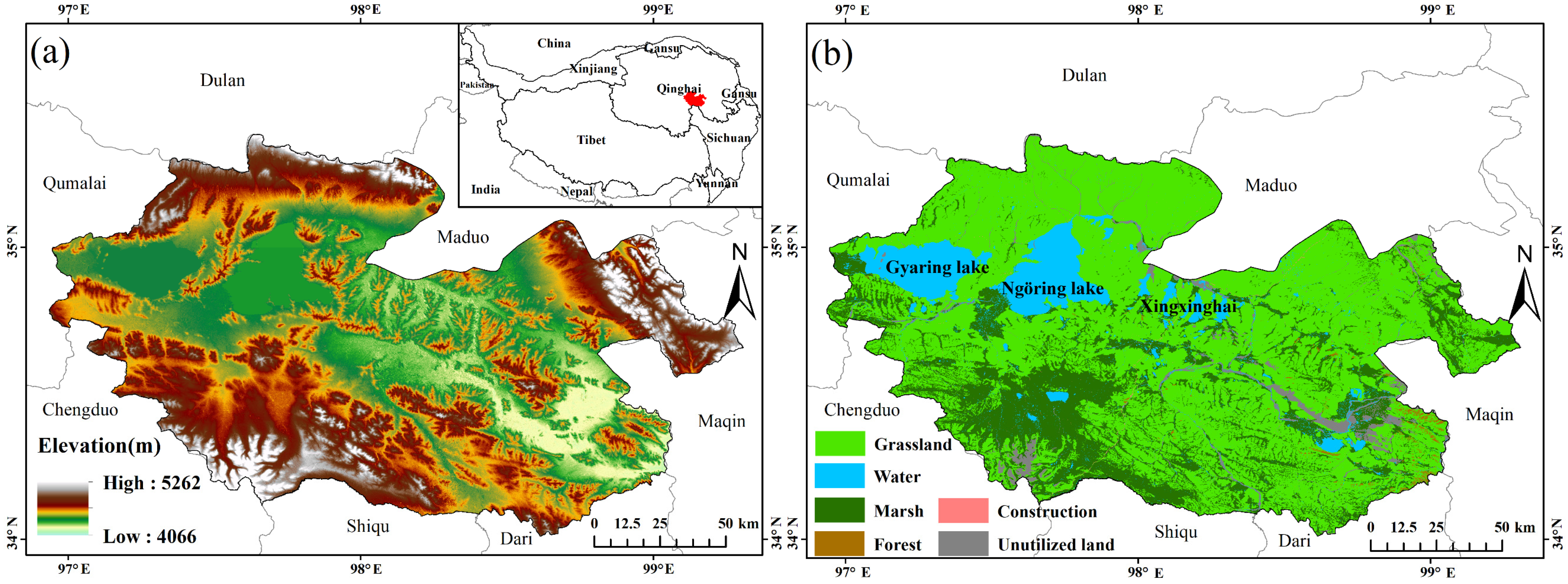
2.1. Study Area
2.2. Wetland Classification System
2.3. Data and Processing
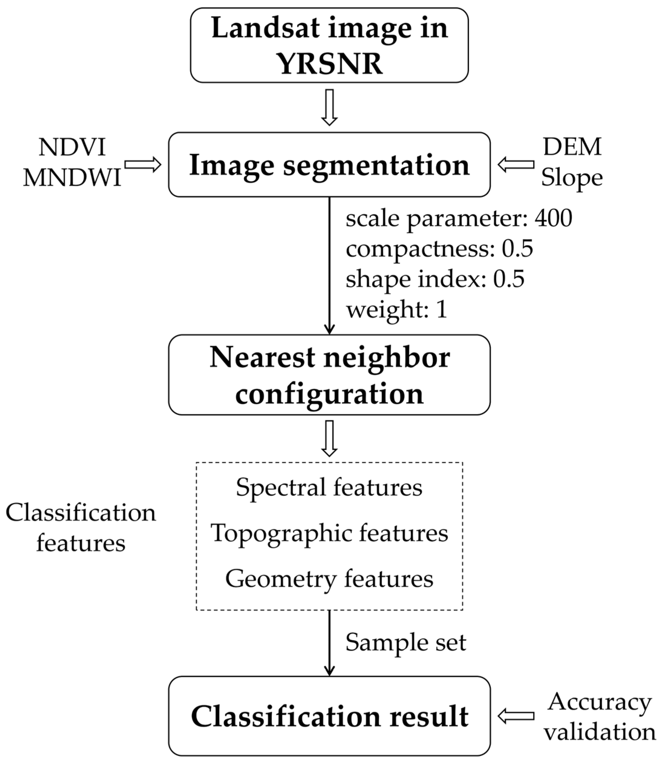
2.4. Object-Based Wetland Classification Method
2.5. Grey Relation Analysis Method
3. Results
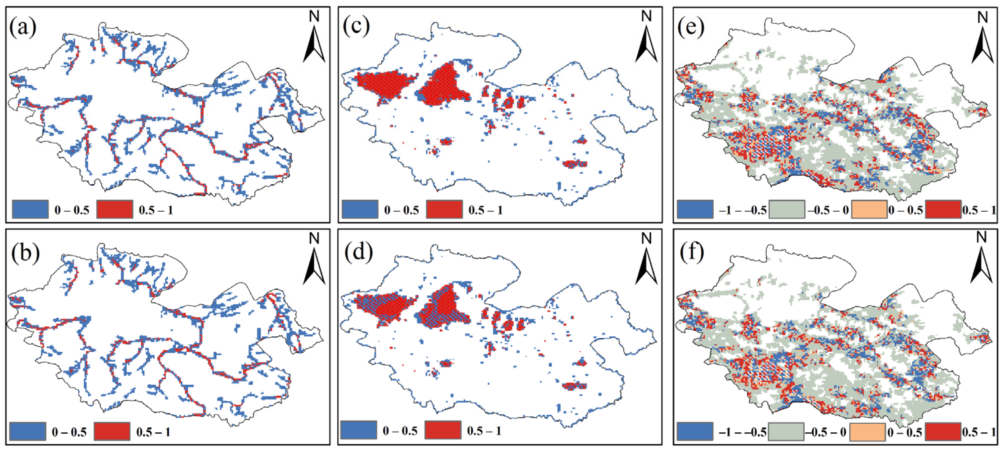
3.1. The Classification Rule Set of Wetlands in the YRSNP
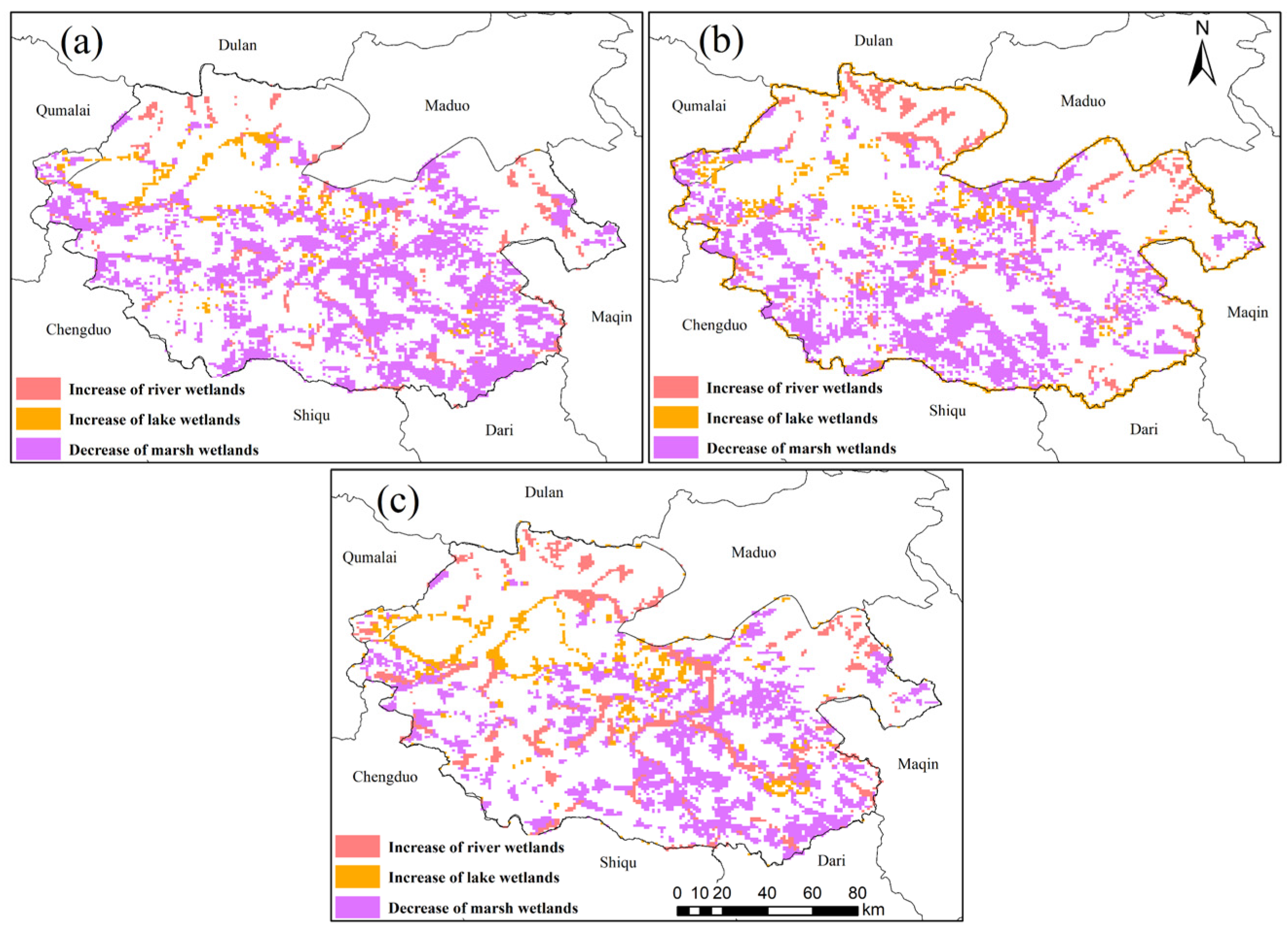
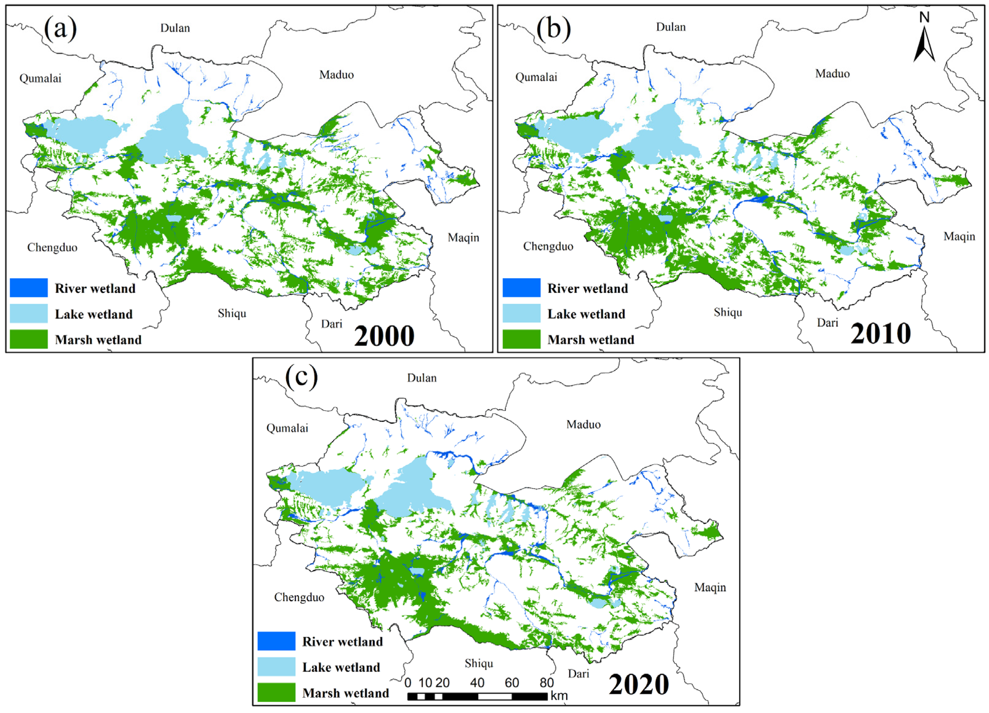
3.2. Spatiotemporal Evolution Pattern of Wetlands in the Three-River-Source Region from 2000 to 2020
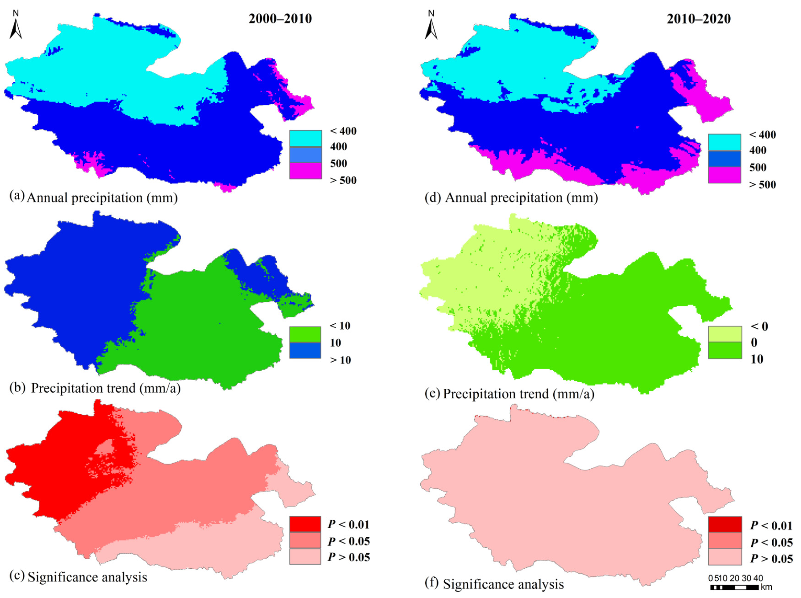
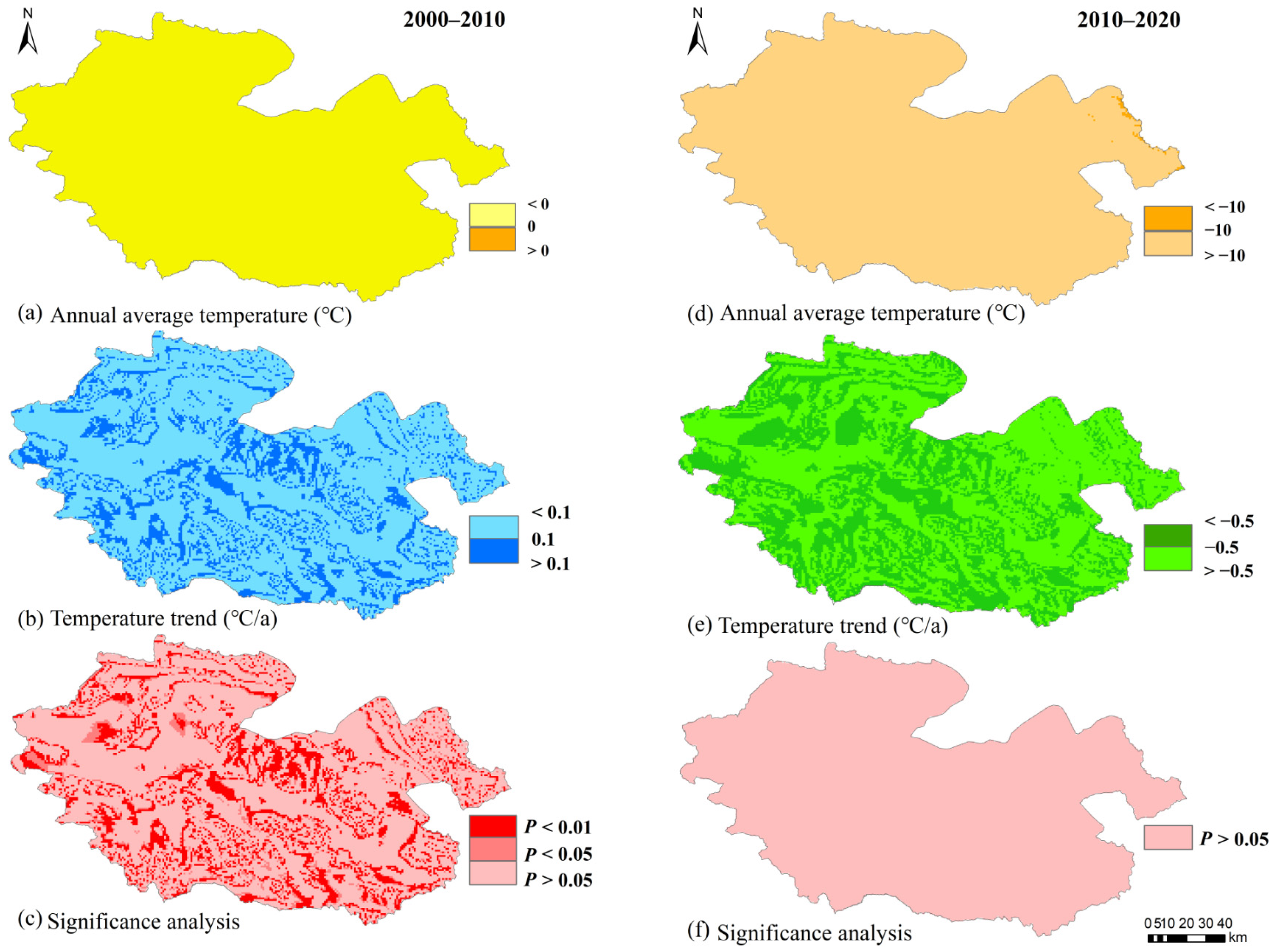
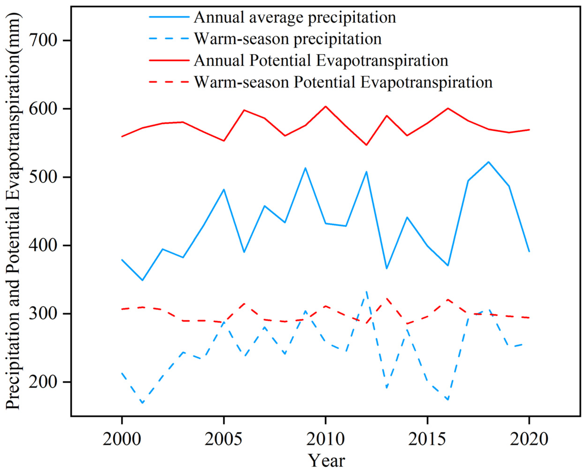
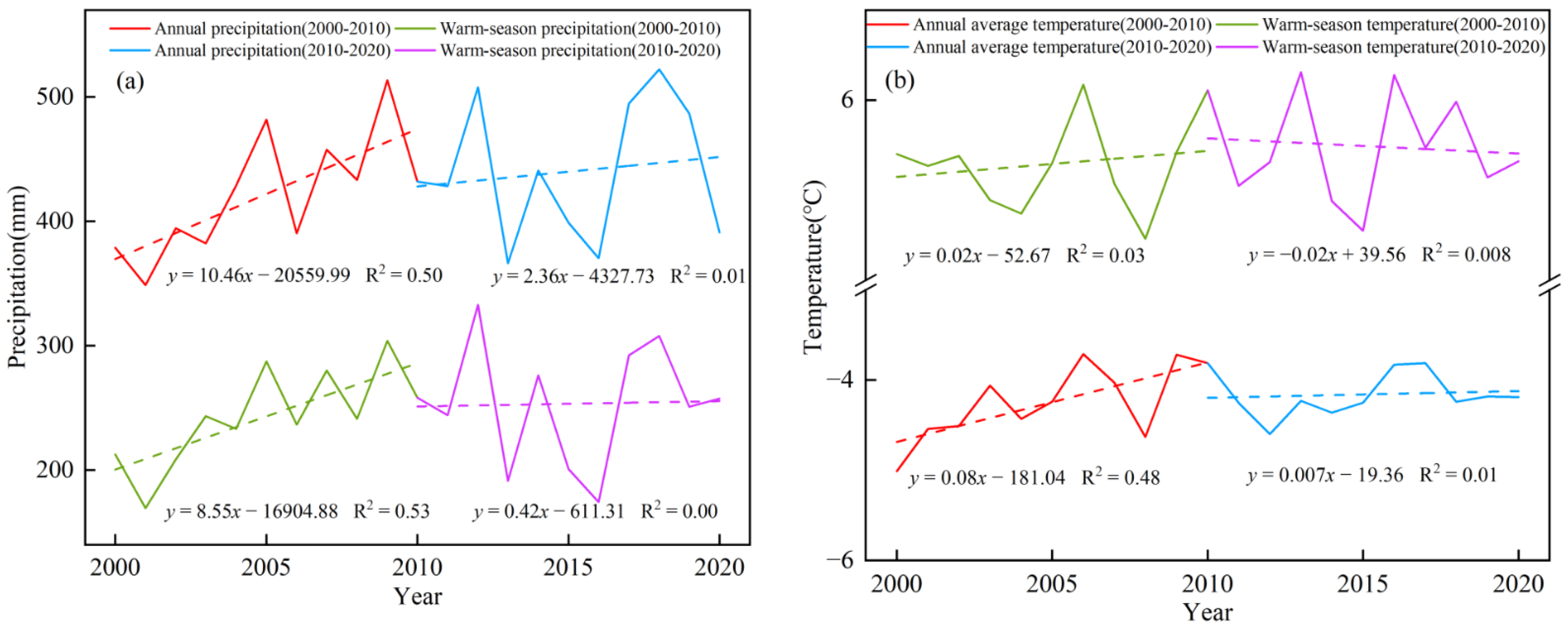
3.3. Spatiotemporal Patterns of Precipitation and Temperature in the YRSNP from 2000 to 2020
3.4. Relationship between Wetland Changes and Climate Change
4. Discussion
5. Conclusions
Author Contributions
Funding
Institutional Review Board Statement
Informed Consent Statement
Data Availability Statement
Acknowledgments
Conflicts of Interest
References
- Fickas, K.C.; Cohen, W.B.; Yang, Z. Landsat-based monitoring of annual wetland change in the Willamette Valley of Oregon, USA from 1972 to 2012. Wetl. Ecol. Manag. 2016, 24, 73–92. [Google Scholar] [CrossRef]
- Ghimire, U.; Nandimandalam, H.; Martinez-Guerra, E.; Gude, V.G. Wetlands for wastewater treatment. Water Environ. Res. 2019, 91, 1378–1389. [Google Scholar] [CrossRef] [PubMed] [Green Version]
- Colvin, S.A.; Sullivan, S.M.P.; Shirey, P.D.; Colvin, R.W.; Winemiller, K.O.; Hughes, R.M.; Fausch, K.D.; Infante, D.M.; Olden, J.D.; Bestgen, K.R. Headwater streams and wetlands are critical for sustaining fish, fisheries, and ecosystem services. Fisheries 2019, 44, 73–91. [Google Scholar] [CrossRef]
- Li, W.; Xue, P.; Liu, C.; Yan, H.; Zhu, G.; Cao, Y. Monitoring and landscape dynamic analysis of alpine wetland area based on multiple algorithms: A case study of Zoige plateau. Sensors 2020, 20, 7315. [Google Scholar] [CrossRef] [PubMed]
- Yu, H.; Liu, B.-T.; Wang, G.-X.; Zhang, T.-Z.; Yang, Y.; Lu, Y.-Q.; Xu, Y.-X.; Huang, M.; Yang, Y.; Zhang, L. Grass-livestock balance based grassland ecological carrying capability and sustainable strategy in the Yellow River Source National Park, Tibet Plateau, China. J. Mt. Sci. 2021, 18, 2201–2211. [Google Scholar] [CrossRef]
- Liu, Z.; Li, S.; Wei, W.; Song, X. Research progress on alpine wetland changes and driving forces in Qinghai-Tibet Plateau during the last three decades. Chin. J. Ecol. 2019, 38, 856–862. [Google Scholar]
- Liu, L.; Cao, W.; Shao, Q.; Huang, L.; He, T. Characteristics of Land Use/Cover and Macroscopic Ecological Changes in the Headwaters of the Yangtze River and of the Yellow River over the Past 30 Years. Sustainability 2016, 8, 237. [Google Scholar] [CrossRef] [Green Version]
- Wang, X.; Chen, R.; Yang, Y. Effects of permafrost degradation on the hydrological regime in the source regions of the Yangtze and Yellow Rivers, China. Water 2017, 9, 897. [Google Scholar] [CrossRef] [Green Version]
- Liu, P.; Guan, L.; Lu, C.; Zhang, M.X.; Lei, G.C. Technical Characteristics and Application Prospects of Achievements of the Second National Wetland Investigation. Wetl. Sci. 2011, 9, 284–289. (In Chinese) [Google Scholar]
- DeLancey, E.R.; Simms, J.F.; Mahdianpari, M.; Brisco, B.; Mahoney, C.; Kariyeva, J. Comparing deep learning and shallow learning for large-scale wetland classification in Alberta, Canada. Remote Sens. 2019, 12, 2. [Google Scholar] [CrossRef] [Green Version]
- Simioni, J.P.; Guasselli, L.A.; de Oliveira, G.G.; Ruiz, L.F.; de Oliveira, G. A comparison of data mining techniques and multi-sensor analysis for inland marshes delineation. Wetl. Ecol. Manag. 2020, 28, 577–594. [Google Scholar] [CrossRef]
- Soltani, K.; Amiri, A.; Zeynoddin, M.; Ebtehaj, I.; Gharabaghi, B.; Bonakdari, H. Forecasting monthly fluctuations of lake surface areas using remote sensing techniques and novel machine learning methods. Theor. Appl. Climatol. 2021, 143, 713–735. [Google Scholar] [CrossRef]
- Russi, D.; ten Brink, P.; Farmer, A.; Badura, T.; Coates, D.; Förster, J.; Kumar, R.; Davidson, N. The Economics of Ecosystems and Biodiversity (TEEB) for Water and Wetlands; IEEP: London, UK, 2013. [Google Scholar]
- Wang, J.; Zhu, Q.; Yang, Y.; Zhang, X.; Zhang, J.; Yuan, M.; Chen, H.; Peng, C. High uncertainties detected in the wetlands distribution of the Qinghai–Tibet Plateau based on multisource data. Landsc. Ecol. Eng. 2020, 16, 47–61. [Google Scholar] [CrossRef]
- Weise, K.; Höfer, R.; Franke, J.; Guelmami, A.; Simonson, W.; Muro, J.; O’Connor, B.; Strauch, A.; Flink, S.; Eberle, J. Wetland extent tools for SDG 6.6. 1 reporting from the Satellite-based Wetland Observation Service (SWOS). Remote Sens. Environ. 2020, 247, 111892. [Google Scholar] [CrossRef]
- Mahdianpari, M.; Salehi, B.; Mohammadimanesh, F.; Homayouni, S.; Gill, E. The first wetland inventory map of newfoundland at a spatial resolution of 10 m using sentinel-1 and sentinel-2 data on the google earth engine cloud computing platform. Remote Sens. 2018, 11, 43. [Google Scholar] [CrossRef] [Green Version]
- Yao, T. TPE international program: A program for coping with major future environmental challenges of The Third Pole region. Prog. Geogr. 2014, 33, 884–892. [Google Scholar]
- Zhao, Z.; Liu, L.; Wang, Z.; Zhang, Y.; Li, L.; Liu, F. Dynamic Changes of Plateau Wetlands in the Damqu River Basin, Yangtze River Source Region, China, 1988–2015. Wetlands 2020, 40, 1409–1424. [Google Scholar] [CrossRef]
- Ma, C.; He, Y. Spatiotemporal Trends and Ecological Determinants in Population by Elevation in China Since 1990. Chin. Geogr. Sci. 2021, 31, 248–260. [Google Scholar] [CrossRef]
- Wang, R.; He, M.; Niu, Z. Responses of alpine wetlands to climate changes on the Qinghai-Tibetan Plateau based on remote sensing. Chin. Geogr. Sci. 2020, 30, 189–201. [Google Scholar] [CrossRef]
- Lang, Q.; Niu, Z.; Hong, X.; Yang, X. Remote Sensing Monitoring and Change Analysis of Wetlands in the Tibetan Plateau. Geomat. Inf. Sci. Wuhan Univ. 2021, 46, 230–237. [Google Scholar]
- Zhang, Y.; Yan, J.; Cheng, X.; He, X. Wetland Changes and Their Relation to Climate Change in the Pumqu Basin, Tibetan Plateau. Int. J. Environ. Res. Public Health 2021, 18, 2682. [Google Scholar] [CrossRef] [PubMed]
- Cao, W.; Liu, L.; Wu, D.; Huang, L. Spatial and temporal variations and the importance of hierarchy of ecosystem functions in the Three-river-source National Park. Acta Ecol. Sin. 2019, 39, 1361–1374. [Google Scholar]
- Hu, G.; Jin, H.; Dong, Z.; Lu, J.; Yan, C. Driving forces of aeolian desertification in the source region of the Yellow River: 1975–2005. Environ. Earth Sci. 2013, 70, 3245–3254. [Google Scholar] [CrossRef]
- Bai, J.; Ouyang, H.; Xu, H.; Zhou, C.; Gao, J. Advances in studies of wetlands in Qinghai-Tibet Plateau. Prog. Geogr. 2004, 23, 1–9. [Google Scholar]
- Gong, P.; Niu, Z.; Cheng, X.; Zhao, K.; Zhou, D.; Guo, J.; Liang, L.; Wang, X.; Li, D.; Huang, H. China’s wetland change (1990–2000) determined by remote sensing. Sci. China Earth Sci. 2010, 53, 1036–1042. [Google Scholar] [CrossRef]
- Peng, S.; Ding, Y.; Liu, W.; Li, Z. 1 km monthly temperature and precipitation dataset for China from 1901 to 2017. Earth Syst. Sci. Data 2019, 11, 1931–1946. [Google Scholar] [CrossRef] [Green Version]
- Peng, S.; Ding, Y.; Wen, Z.; Chen, Y.; Cao, Y.; Ren, J. Spatiotemporal change and trend analysis of potential evapotranspiration over the Loess Plateau of China during 2011–2100. Agric. For. Meteorol. 2017, 233, 183–194. [Google Scholar] [CrossRef] [Green Version]
- Allen, R.G.; Pereira, L.S.; Raes, D.; Smith, M. Crop evapotranspiration-Guidelines for computing crop water requirements-FAO Irrigation and drainage paper 56. Fao Rome 1998, 300, D05109. [Google Scholar]
- Ma, L.; Li, M.; Ma, X.; Cheng, L.; Du, P.; Liu, Y. A review of supervised object-based land-cover image classification. ISPRS J. Photogramm. Remote Sens. 2017, 130, 277–293. [Google Scholar] [CrossRef]
- Zhang, C.H.; Li, X.N.; Wu, M.Q.; Qin, W.S.; Zhang, J. Object-oriented Classification of Land Cover Based on Landsat 8 OLI Image Data in the Kunyu Mountain. Sci. Geogr. Sin. 2018, 38, 1904–1913. (In Chinese) [Google Scholar]
- Landis, J.R.; Koch, G.G. The measurement of observer agreement for categorical data. Biometrics 1977, 33, 159–174. [Google Scholar] [CrossRef] [PubMed] [Green Version]
- Fang, L.; Dong, B.; Wang, C.; Yang, F.; Cui, Y.; Xu, W.; Peng, L.; Wang, Y.; Li, H. Research on the influence of land use change to habitat of cranes in Shengjin Lake wetland. Environ. Sci. Pollut. Res. 2020, 27, 7515–7525. [Google Scholar] [CrossRef]
- Shen, G.; Yang, X.; Jin, Y.; Xu, B.; Zhou, Q. Remote sensing and evaluation of the wetland ecological degradation process of the Zoige Plateau Wetland in China. Ecol. Indic. 2019, 104, 48–58. [Google Scholar] [CrossRef]
- Li, F.; Chang, G.; Xiao, J.; Zhou, B.-R.; Fu, Y. Relationship between wetlands changes and climate change in the Yellow River source region. J. Nat. Resour. 2009, 24, 683–690. [Google Scholar]
- Brierley, G.J.; Li, X.; Cullum, C.; Gao, J. Landscape and Ecosystem Diversity, Dynamics and Management in the Yellow River Source Zone; Springer: Cham, Switzerland, 2016. [Google Scholar]
- Song, X.; Yang, G.; Yan, C.; Duan, H.; Liu, G.; Zhu, Y. Driving forces behind land use and cover change in the Qinghai-Tibetan Plateau: A case study of the source region of the Yellow River, Qinghai Province, China. Environ. Earth Sci. 2009, 59, 793–801. [Google Scholar] [CrossRef]
- Luo, C.; Hao, M.; Li, Y.; Tong, L. Monitoring the changes of wetlands in the Source Region of Three Rivers with remote sensing data from 1976 to 2013. In Proceedings of the 2016 4th International Workshop on Earth Observation and Remote Sensing Applications (EORSA), Guangzhou, China, 4–6 July 2016; pp. 198–201. [Google Scholar]
- Ablat, X.; Wang, Q.; Arkin, N.; Guoping, T.; Sawut, R. Spatiotemporal variations and underlying mechanism of the floodplain wetlands in the meandering Yellow River in arid and semi-arid regions. Ecol. Indic. 2022, 136, 108709. [Google Scholar] [CrossRef]
- Li, X.; Xue, Z.; Gao, J. Dynamic changes of plateau wetlands in Madou County, the Yellow River source zone of China: 1990–2013. Wetlands 2016, 36, 299–310. [Google Scholar] [CrossRef]
- Yang, K.; Ye, B.; Zhou, D.; Wu, B.; Foken, T.; Qin, J.; Zhou, Z. Response of hydrological cycle to recent climate changes in the Tibetan Plateau. Clim. Chang. 2011, 109, 517–534. [Google Scholar] [CrossRef]
- Xi, Y.; Miao, C.; Wu, J.; Duan, Q.; Lei, X.; Li, H. Spatiotemporal Changes in Extreme Temperature and Precipitation Events in the Three-Rivers Headwater Region, China. J. Geophys. Res. Atmos. 2018, 123, 5827–5844. [Google Scholar] [CrossRef]
- Meng, F.; Su, F.; Yang, D.; Tong, K.; Hao, Z. Impacts of recent climate change on the hydrology in the source region of the Yellow River basin. J. Hydrol. Reg. Stud. 2016, 6, 66–81. [Google Scholar] [CrossRef] [Green Version]
- Xue, Z.; Lyu, X.; Chen, Z.; Zhang, Z.; Jiang, M.; Zhang, K.; Lyu, Y. Spatial and temporal changes of wetlands on the Qinghai-Tibetan Plateau from the 1970s to 2010s. Chin. Geogr. Sci. 2018, 28, 935–945. [Google Scholar] [CrossRef] [Green Version]
- Du, J.; Wang, G.; Yang, Y.; Zhang, T.; Mao, T. Temporal and spatial variation of the distributive patterns and driving force analysis in the Yangtze River and Yellow River source regions wetland. Acta Ecol. Sin. 2015, 35, 6173–6182. [Google Scholar]
- Jin, X.; Jin, H.; Luo, D.; Sheng, Y.; Wu, Q.; Wu, J.; Wang, W.; Huang, S.; Li, X.; Liang, S. Impacts of Permafrost Degradation on Hydrology and Vegetation in the Source Area of the Yellow River on Northeastern Qinghai-Tibet Plateau, Southwest China. Front. Earth Sci. 2022, 10, 845824. [Google Scholar] [CrossRef]
- Amani, M.; Mahdavi, S.; Kakooei, M.; Ghorbanian, A.; Brisco, B.; DeLancey, E.R.; Toure, S.; Reyes, E.L. Wetland Change Analysis in Alberta, Canada using Four Decades of Landsat Imagery. IEEE J. Sel. Top. Appl. Earth Obs. Remote Sens. 2021, 14, 10314–10335. [Google Scholar] [CrossRef]
- Luo, N.; Yu, R.; Mao, D.; Wen, B.; Liu, X. Spatiotemporal variations of wetlands in the northern Xinjiang with relationship to climate change. Wetl. Ecol. Manag. 2021, 29, 617–631. [Google Scholar] [CrossRef]
- Dong, L.; Xu, M. Dynamic Changes of the Alpine Wetlands in Tibet, China. In Proceedings of the IGARSS 2018–2018 IEEE International Geoscience and Remote Sensing Symposium, Valencia, Spain, 22–27 July 2018; pp. 9229–9232. [Google Scholar]
- Shao, Q.; Cao, W.; Fan, J.; Huang, L.; Xu, X. Effects of an ecological conservation and restoration project in the Three-River Source Region, China. J. Geogr. Sci. 2017, 27, 183–204. [Google Scholar] [CrossRef]


| Category | Description | Remote Sensing Image | Field Image |
|---|---|---|---|
| River wetland | Natural linear waterbody with flowing water in the wetland area | 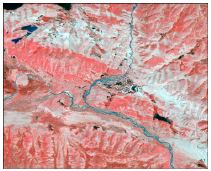 | 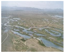 |
| Lake wetland | Natural polygon waterbody with standing water in the wetland area | 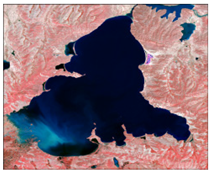 | 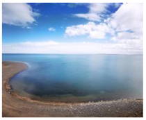 |
| Marsh wetland | Natural wetland with dominant woody vegetation and dominant herbaceous vegetation in the wetland area |  | 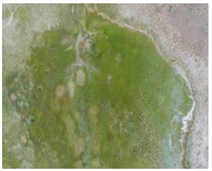 |
| Category | Feature | Description | Application |
|---|---|---|---|
| Spectral features | Blue | Different bands of Landsat image | Image segmentation |
| Green | |||
| Red | |||
| NIR | |||
| SWIR1 | |||
| SWIR2 | |||
| annual NDVImax | (NIR − Red)/(NIR + Red) Annual maximum NDVI | ||
| annual MNDWImax | (Green − SWIR)/(Green + SWIR) Annual maximum NDVI | ||
| Mean | Layer mean value calculated from the layer values of all pixels forming an image object. | Classification rules | |
| Brightness | Sum of the mean values of the layers containing spectral information divided by their quantity computed for an image object. | ||
| StdDev | Standard deviation calculated from the layer values of all n pixels forming an image object. | ||
| Topographic features | DEM (m) | DEM with a resolution 30 m. | Image segmentation |
| Slope (°) | Generated from DEM. | ||
| Geometry features | Length (m) | The length can be calculated using the length-to-width ratio derived from a bounding box approximation. | Classification rules |
| Length/Width | Length-to-width ratio of an image object. | ||
| Density | Describe the distribution of an image object in pixel space. | ||
| Shape index | The smoothness of an image object’s border. |
| Kappa Coefficient | Strength of Agreement |
|---|---|
| <0 | Poor |
| 0~0.2 | Slight |
| 0.2~0.4 | Fair |
| 0.4~0.6 | Moderate |
| 0.6~0.8 | Substantial |
| 0.8~1 | Almost perfect |
| Classification Rules | River Wetland | Lake Wetland | Marsh Wetland |
|---|---|---|---|
| Density | 0.29–1.58 | 0.89–2.37 | 0.98–2.26 |
| Length (m) | 190.51–831.93 | 109.22–552.41 | 116–560.62 |
| Length/Width | 2.09–10.95 | 1.02–3.31 | 1.01–5.71 |
| Shape index | 2.67–11.85 | 1.75–5.67 | 3.33–5.37 |
| NDVI | 0.033–0.38 | –0.073–0.055 | 0.31–0.73 |
| NDWI | 0.38–0.90 | 0.86–0.95 | 0.18–0.78 |
| DEM (m) | 4161.78–4328.23 | 4162.00–4421.41 | 4164.41–4277.41 |
| Slope (°) | 2.35–13.92 | 0–9.44 | 2.48–7.67 |
| Wetland Categories | Kappa Coefficient | Overall Accuracy | ||||
|---|---|---|---|---|---|---|
| 2000 | 2010 | 2020 | 2000 | 2010 | 2020 | |
| River wetland | 0.55 | 0.58 | 0.68 | 0.60 | 0.62 | 0.69 |
| Lake wetland | 0.81 | 0.85 | 0.85 | 0.94 | 0.95 | 0.95 |
| Marsh wetland | 0.59 | 0.65 | 0.71 | 0.68 | 0.75 | 0.81 |
| Total wetland | 0.63 | 0.70 | 0.75 | 0.73 | 0.77 | 0.82 |
| Wetland Categories | 2000 | 2010 | 2020 | 2000–2010 | 2010–2020 | 2000–2020 | ||||||
|---|---|---|---|---|---|---|---|---|---|---|---|---|
| % | % | % | Change% | Change% | Change% | |||||||
| River wetland | 399.05 | 6.63 | 415.16 | 7.14 | 428.69 | 7.88 | 16.11 | 4.04 | 13.53 | 3.25 | 29.64 | 7.42 |
| Lake wetland | 1426.24 | 23.69 | 1486.33 | 25.57 | 1517.43 | 26.07 | 60.09 | 4.21 | 31.1 | 2.09 | 91.19 | 6.01 |
| Marsh wetland | 4196.10 | 69.69 | 3910.21 | 67.28 | 3843.67 | 66.04 | −285.89 | −6.81 | −66.54 | −1.70 | −352.43 | −9.17 |
| Total | 6254.56 | 100.00 | 5811.70 | 100.00 | 5819.79 | 100.00 | −442.86 | −7.08 | 8.09 | 0.14 | −434.77 | −7.47 |
| Climate Factors | River Wetland | Lake Wetland | Marsh Wetland | Total Wetland |
|---|---|---|---|---|
| Annual average precipitation | 0.7126 | 0.8005 | 0.6375 | 0.6629 |
| Warm-season precipitation | 0.6347 | 0.6600 | 0.5579 | 0.5570 |
| Annual average temperature | 0.5642 | 0.5713 | 0.8054 | 0.6869 |
| Warm-season temperature | 0.6742 | 0.7551 | 0.6679 | 0.7122 |
Publisher’s Note: MDPI stays neutral with regard to jurisdictional claims in published maps and institutional affiliations. |
© 2022 by the authors. Licensee MDPI, Basel, Switzerland. This article is an open access article distributed under the terms and conditions of the Creative Commons Attribution (CC BY) license (https://creativecommons.org/licenses/by/4.0/).
Share and Cite
Ma, T.; She, Y.; Zhao, L.; Hu, B.; Feng, X.; Zhao, J.; Zhao, Z. Alpine Wetland Evolution and Their Response to Climate Change in the Yellow-River-Source National Park from 2000 to 2020. Water 2022, 14, 2351. https://doi.org/10.3390/w14152351
Ma T, She Y, Zhao L, Hu B, Feng X, Zhao J, Zhao Z. Alpine Wetland Evolution and Their Response to Climate Change in the Yellow-River-Source National Park from 2000 to 2020. Water. 2022; 14(15):2351. https://doi.org/10.3390/w14152351
Chicago/Turabian StyleMa, Tao, Yandi She, Li Zhao, Bixia Hu, Xueke Feng, Jing Zhao, and Zhizhong Zhao. 2022. "Alpine Wetland Evolution and Their Response to Climate Change in the Yellow-River-Source National Park from 2000 to 2020" Water 14, no. 15: 2351. https://doi.org/10.3390/w14152351