Article

Soil Water Behavior of Sandy Soils under Semiarid Conditions in the Shendong Mining Area (China)

1
State Key Laboratory of Water Resource Protection and Utilization in Coal Mining, Beijing 102209, China
2
School of Earth and Environment, Anhui University of Science and Technology, Huainan 232001, China
3
Shenhua Shendong Coal Group Co., Ltd. Technology Research Institute, Shenmu 719315, China
4
Engineering Research Center of Ministry of Education for Mine Ecological Restoration, China University of Mining and Technology, Xuzhou 221116, China
*
Author to whom correspondence should be addressed.
Water 2022, 14(14), 2159; https://doi.org/10.3390/w14142159
Submission received: 20 April 2022 / Revised: 29 June 2022 / Accepted: 4 July 2022 / Published: 7 July 2022
(This article belongs to the Section Soil and Water)

Abstract

:
The soil water behavior of sandy soils was studied under semiarid conditions in the Shendong mining area (China). The soil water content (θ) was measured under different depths and topographies using an HH2 moisture meter. The infiltration process was studied using a Guelph soil permeameter. A set of hydrodynamic variables was calculated in the laboratory. The θ of the first 20 cm was the lowest and increased with depth. The content of soil water increased from the top slope to the bottom slope. The infiltration experiments showed that the steady state infiltration rate was >40 mm h−1 in most cases. Owing to the higher contents of sand and soil macropores at the top of the slope and the top 0–20 cm of surface soil, the initial infiltration rate and steady infiltration rate were higher. The average available water capacity was 18.28%, which was consistent with the predominance of a sandy textural fraction. The results of a soil water retention curve and a rainfall simulation experiment showed that there was a low soil water retention capacity throughout the whole profile. This study contributes to the understanding of several aspects of the soil water behavior of sandy soils and provides key information for environmental management and land reclamation under semiarid conditions in the Shendong mining area.

1. Introduction

Soil water resources, an important part of the water cycle, are the basis for the survival of plants. In arid and semiarid regions, owing to the extremely fragile ecological system, soil moisture serves as the key ecological and environmental factor of plant growth [1,2,3,4,5]. It is an important indicator for monitoring land degradation [6,7] and an important input factor of terrestrial ecosystems [8]. It is also the key element of agricultural systems and hydrological and climatic elements [9].
In arid and semiarid environments, water stress affects many properties of the soil, including the decay of the soil’s organic matter (OM), the characteristics of soil infiltration, the composition of soil granulometry, and the mineralization of soil nutrients [10,11]. OM provides necessary nutrients and improves soil fertility [12]. In addition, the OM retains water, stabilizes the soil structure, and renders the soil more resistant to degradation [13]. The infiltration process of soil water determines the redistribution of rainwater on the surface, which has an important influence on the content of water in the topsoil [14,15,16]. Soil moisture is affected by the soil’s granulometric composition. Particularly in semiarid areas, where the evaporation is greater than the precipitation in the summer, the soil granulometric composition has a significant impact on the soil water content [17,18]. Consequently, knowledge of soil water behavior and the relationship between these factors and soil moisture in a semiarid ecosystem is very important.
During the past few decades, numerous studies on the primary related factors of water behavior have been conducted in the top layers of semiarid soil. Ceballos et al. [10] investigated the soil behavior of sandy soils in the Duero Basin (Spain) under semiarid conditions. Mathur and Sundaramoorthy [19] explored the patterns of richness of herbaceous species and productivity along gradients of soil moisture and nutrients in the Indian Thar Desert. Tillman et al. [20] used the basin characteristics model and the groundwater recharge model to estimate the basin-scale potential evapotranspiration of soil moisture in the Verde Valley (Arizona, USA). Guo [21] studied the limits of soil water resource use in a semiarid loess hilly area. Dong [22] presented results from a study of the storage of soil moisture by different land use types in the Ningxia semiarid loess hilly area in China. The rates of litter production and the influences of soil moisture on the interannual variability during the respiration of litter in the semiarid Loess Plateau were studied by Zhang et al. [23]. The content of soil water in most semiarid ecosystems is not only influenced by air temperature and humidity, but also by the soil’s physical characteristics, such as texture. Many studies have shown the strong relationships between the content of soil water and the physical characteristics of soil [24,25,26]. In addition, the soil water retention capacity was considered to be an important indicator of soil quality according to Fayos [27]. However, considering the mutual and multiple influences on soil moisture in semiarid areas, the relative importance of these factors merits further study [24,28]. A better understanding of the soil water behavior of sandy soils under the semiarid conditions in the Shendong mining area would provide theoretical guidance for land reclamation and plant restoration in this area.
The primary purpose of this study was to analyze the soil water behavior of the sandy soils in a representative wind drift sand region at the junction of the Loess Plateau and the Maowusu Desert in China. The detailed objectives of this study were as follows: (1) to describe the relationships between soil moisture and the physical properties of the study area, (2) to study the infiltration process by the method of a set of field experiments using a Guelph soil permeameter, (3) to calculate the available soil water content using the water retention curves, and (4) to analyze the soil water retention capacity according to the results of the water retention curves and a rainfall experiment.

2. Materials and Methods

2.1. Study Sites

The study was conducted at the Bulianta coal mine of the Shendong mining area, Erdos City, the Inner Mongolia Autonomous Region, north China (Figure 1), with an altitude of more than 1000 m. The sampling sites for this study were located within 116°21′ E to 117°11′ E and 38°52′ N to 39°50′ N. The area studied has a temperate continental climate with an annual average temperature of 6.2 °C, an average annual precipitation of 436.7 mm, and an annual evaporation of 2163 mm, since this is the semiarid part of north China [29,30]. The soil texture is sandy in the upper part of the soil profile. The surface is covered by quicksand and semi-fixed sand. The areas of desertification and potential desertification account for approximately 85% of the total area under semiarid climatic conditions [30].
The study site underwent an intensive process of coal exploitation throughout its history, which led to the destruction of surface vegetation. Artificial vegetation occupies a large proportion of the study area. The dominant vegetation primarily includes psammophytes, such as sea buckthorn (Hippophae rhamnoides), Salix psammophila, and Caragana spp.

2.2. Soil Moisture Measurements

The surface soil moisture (θ) was measured at the six most representative points of the sandy soils of the study area. Two points were installed at the top (TS1 and TS2), middle (MS3 and MS4), and bottom (BS5 and BS6) of the slope. The points where the measurements were conducted in the study area included the top of slope, which was primarily covered by S. psammophila and Caragana, and the middle and bottom of the slope, with a predominant cover of sea buckthorn and Caragana. In all cases, the surface was undulating, and the slope gradients did not exceed 5%. An HH2 Moisture Meter (Theta-probe Type ML2x; Delta-T Devices, Ltd., Cambridge, UK) [31] was used, with three probes that were 6.8 cm long and three different analogue outputs. One of the probes was used to measure the volumetric water content; the others can be used to measure the bulk electrical conductivity and temperature, but they were not used for this paper. The probes were installed vertically at each soil moisture measurement point and measured the soil moisture at 0–20, 20–40, and 40–60 cm below the soil surface, respectively. Three duplicate readings were measured at each measurement point, which was sampled every hour [24]. The positions of the measurement sites were recorded by GPS.
To study the soil water retention capacity, the after-rainfall soil moisture also needed to be measured at each control point. During the period of 4 June 2016 to 5 June 2016, there was 22.2 mm of rainfall in the study area based on the records of the meteorological station located 10 km away from the study site. When it had finished raining, a 1 m × 1 m × 1 m profile was excavated from the slope at TS1 and TS2, MS3 and MS4, and BS5 and BS6 with a shovel. An HH2 Moisture Meter (Theta-probe Type ML2x; Delta-T Devices, Ltd., Cambridge, UK) was used to measure three replicates of soil moisture along the soil profile at 0–20, 20–40, and 40–60 cm deep. The measurements were made at intervals of 0, 1, 10, and 48 h after the rain had fallen.

2.3. Soil Infiltration Experiments

The soil infiltration experiments were performed near six soil moisture control points to conduct a detailed study of the topsoil’s water infiltration features and saturated hydraulic conductivity, using a Guelph soil permeameter (Zeal Quest Scientific Technology Co., Ltd., Shanghai, China) as described by Reynolds et al. [32], Li et al. [16], and Kuráž [33]. A detailed description of the Guelph soil permeameter has been provided by Kuráž [33] and Reynolds et al. [32]. At least three duplicate measurements of the topsoil were taken at each measurement site. A constant depth of 20 cm was selected for the boreholes, as described by Kuráž [33] and Reynolds et al. [32]. A brush was used to clean the wall of borehole to eliminate the non-permeable membrane produced by the auger before measuring. The saturated hydraulic conductivity (Ksat) was calculated according to the following equation:
K sat = C Q 2 π H 2 + C π a 2 ,
where C is a dimensionless factor that is a function of the soil texture and the H/a ratio; Q (m3·s−1) is the quasi-steady flow infiltrating into the vertical borehole; a (m) is the radius of the borehole; and H (m) is the height of the water level maintained above the borehole bottom [33].

2.4. Soil Sampling and Laboratory Analyses

To calculate the soil’s physical and hydrodynamic properties in the laboratory, each plot was divided into two equal subplots to sample disturbed and undisturbed soil [34]. Three duplicate soil samples were taken from the center of each subplot at depths of 0–20 cm, 20–40, and 40–60 cm in June 2016.
The bulk density (BD) was determined using a 100 cm3 (5.1 cm in diameter × 5 cm high) steel cylinder on the undisturbed soil samples, close to where the soil moisture had been measured [35,36,37,38]. Approximately 100 g of disturbed soil samples were collected for analyses of the soil’s granulometric composition (GC) as previously described [24,39,40,41] and the OM content using the Walkley–Black wet digestion method [24,42]. Based on a study by Zhang et al. [43], the following equation was used to fit the soil water retention curve:
θ = a φ b ,
where θ (%) is the volumetric water content; φ (kPa) is the soil water suction, and a and b are fitting parameters. The soil’s volumetric water content under different amounts of soil water suction (six different matric potentials φ: 100, 200, 500, 700, 1300 and 1500 kPa) was determined using an HH2 Moisture Meter (Delta-T, Inc., Makati, Philippines). The value of θ was measured at nine soil water potential values, which ranged from −33 to −1500 kPa [24]. The field capacity (FC) equaled the content of soil moisture at a soil water potential of −33 kPa, and the wilting point (WP) equaled the content of soil moisture at a soil water potential of −1500 kPa [10,24,44]. Thus, the available water capacity (AWC) of each collected soil sample was calculated using the following equation: AWC = FC − WP.

2.5. Statistical Analysis

The data were analyzed using Microsoft Excel (Redmond, WA, USA) and Origin 9.1 for Windows (OriginLab, Northampton, MA, USA). A Pearson’s correlation coefficient analysis was used to determine the relationships between the soil moisture and the physical properties. The spatial distribution of the soil moisture was estimated using the geostatistical analytical software ArcGIS version 10.1 (ESRI, Redlands, CA, USA).

3. Results and Discussion

3.1. Soil Moisture and Physical Properties

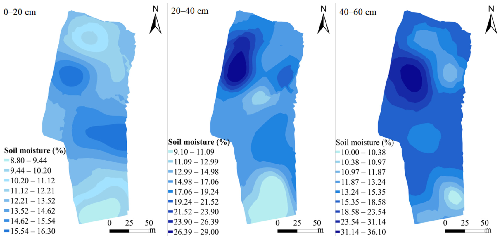
The spatial distribution (0–20, 20–40, and 40–60 cm) of the soil moisture is shown in Figure 2. The amount of moisture in the first 20 cm of topsoil was between 8.88% and 16.30%, and that of the 20–40 cm and 40–60 cm topsoil was from 9.10% to 29.0% and 10.0% to 36.10%, respectively. The soil moisture of the first 20 cm was obviously lower, since it increased with depth. The mean water content of the 0–20, 20–40, and 40–60 cm topsoil was 13.73%, 16.97%, and 18.26%, respectively. The soil moisture increased with a decrease in the slope height. The highest soil moisture was observed at the bottom of the slope (BS). The values of soil moisture were in the following order: BS > MS > TS.
The soil texture classification standards of the USDA indicated that the soil texture at the soil sampling points was loamy sand and sandy loam (Figure 3). The mean fractions of sand, silt, and clay were 80.50%, 9.77%, and 9.73%, respectively (Table 1). The clay fraction was highly variable and ranged from 3.73% to 13.35%. The silt fraction was also quite variable and ranged between 7.66% and 13.89%. The sand fraction was less variable (coefficient of variation, CV = 3.92%) compared with the higher spatial variability of the silt (CV = 14.22%) and clay (CV = 29.32%) fractions. An important decrease in the sand fraction was observed at the sampling sites from the top of the slope to the bottom of the slope, and the fraction of clay was higher at the bottom of the slope, accordingly. Table 1 also shows the marked regularity of the soil texture along the profile (0–20, 20–40, and 40–60 cm). The sand fraction decreased with depth, while the clay fraction increased. These phenomena are primarily attributed to the migration of fine earth. This result was similar to that of Ceballos et al. [10].
The OM content was between 0.29% and 0.60% with a mean value of 0.45% and a CV value of 22.85%. At each sampling site, the amount of OM in the first layer (0–20 cm) was obviously higher than those of the other two layers (20–40 and 40–60 cm). Liu et al. [44] and Ceballos et al. [10] found similar results in sandy soils. At the top of a slope, the soil’s OM content was lower than that at the bottom of the slope. This could be explained by the multiple influences of the decomposition of animal and plant residues, root exudates, microbial synthesis, and surface runoff. As shown in Table 1, the values of the soil BD were very similar, with a CV value of 4.24% and an average measured value of 1.69 g cm–3. The values of the saturated soil hydraulic conductivity (Ksat) were between 5.01 and 54.0 cm h–1 with a mean value of 20.38 cm h–1 and high spatial variability (CV = 79.91%). The Ksat of the top of the slope was higher than those in the rest of the study area, with a maximum value of 54.0 cm h–1. The lowest Ksat was found at the middle of the slope, with a value of 5.01 cm h–1.
The soil moisture content is the key environmental factor for semiarid areas. It is generally influenced by the soil’s physical properties, such as the soil texture, BD, the OM content, and the hydraulic conductivity. In addition, the soil moisture content is also related to topographic factors. The influence of these factors cannot be studied independently of each other. To better understand these interactions in a semiarid area of north China, the relationships between the soil moisture and soil texture, BD, OM content, hydraulic conductivity, and topographic factors were analyzed in this study.
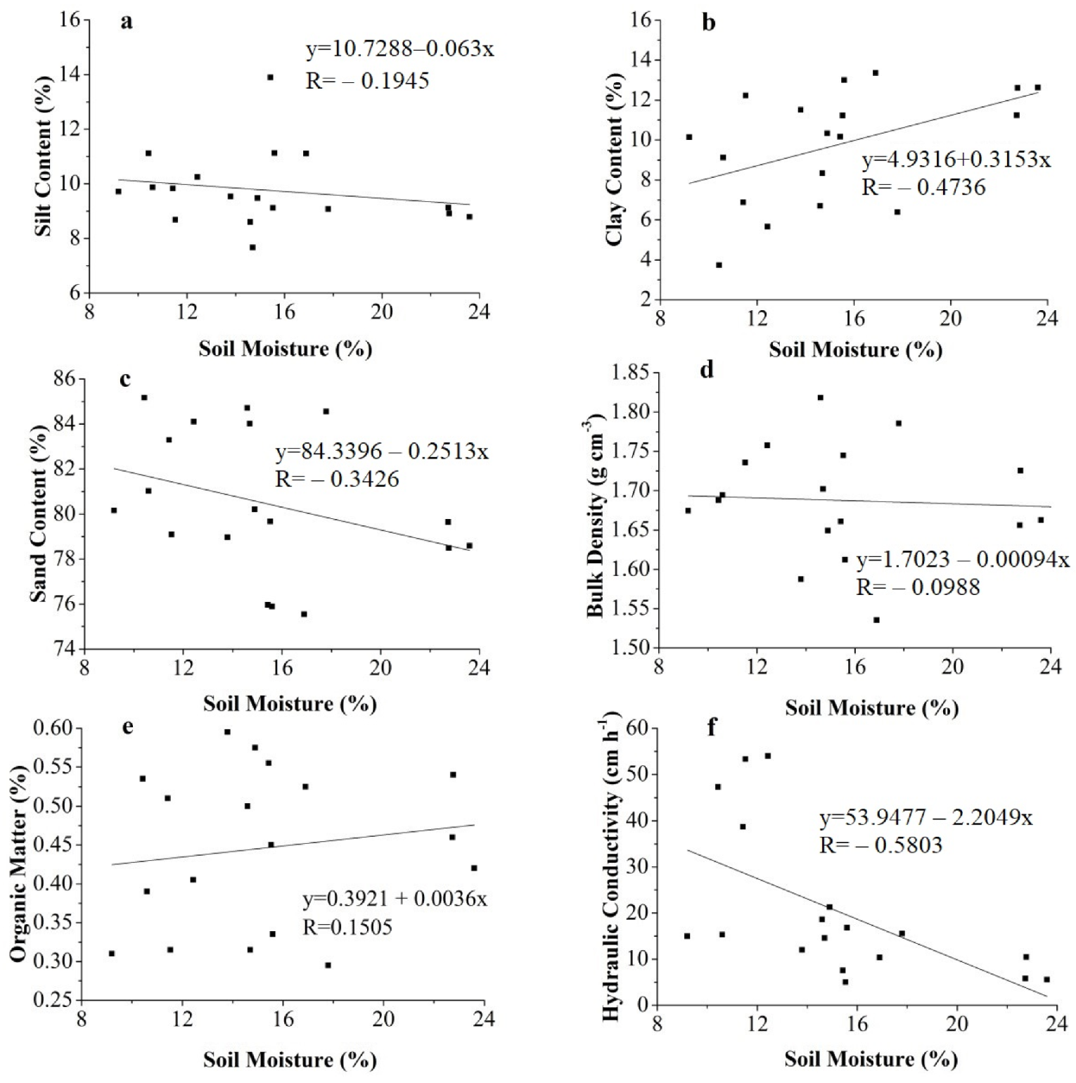
Figure 4 shows the relationships between soil moisture and soil texture, BD, OM content, and hydraulic conductivity. Figure 4a–c show the relationship between the soil moisture and soil particles in the study area. These analyses revealed that the soil moisture content and the sand and silt content were negatively correlated, with correlation coefficients of −0.3426 and −0.1945, respectively. The content of clay in the soil was positively correlated with the soil moisture content, with a correlation coefficient of 0.4735. This phenomenon is supported by previous research [11,17]. Zhang et al. [11] found that the soil moisture was primarily affected by the content of clay, and the relationship between contents of soil moisture and clay was highly significant. Li [17] showed that the soil water content and the soil particle composition are directly related. Smaller soil particles result in a greater surface area of the soil and a higher maximum moisture content. This further explains the relationship between the soil moisture content and the soil particles. The relationship between soil moisture and BD is shown in Figure 4d. A negative linear correlation was used to fit the relationship between soil moisture and BD, but the low R value indicated that such a relationship might not exist. The value equaled t −0.0988. The BD showed very similar values and a mean value of 1.69 g cm–3. The BD is a less important variable for the soil moisture when compared with the soil texture, the OM content, and the hydraulic conductivity in this study. Figure 4e shows the relationship between soil moisture and the OM content. The fitted linear curve for the soil moisture and organic matter was y = 0.3921 + 0.0036x, with R = 0.1505. As previously described [38,45], the soil OM was sensitive to soil moisture. Research by Zhang and Shao [38] showed a significant effect of the soil OM content on soil moisture. The soil moisture content increased with an increase in OM content, and an appropriate increase in OM content could improve the soil water storage capacity. This study identified a positive correlation for the relationship between soil moisture and OM, but a low R value indicated that such a relationship might not exist. The low value of R was primarily attributed to the low OM of the surface soil samplings in this study area. The relationship between soil moisture and the saturated soil hydraulic conductivity is shown in Figure 4f. The fitted linear curve for soil moisture and saturated soil hydraulic conductivity was y = 53.9477 − 2.2049x, with R = −0.5803. This revealed that the content of soil water was negatively correlated with the soil’s saturated hydraulic conductivity. A higher saturated soil hydraulic conductivity (Ksat) resulted in a weakening of the soil’s ability to retain water. In contrast, the soil had a strong water retention capacity. This result is supported by a previous study [46]. In addition, the soil particle size had an important influence on the Ksat. Soil particles with larger diameters were not conducive to the formation of capillary pores, since the content of fine particles, such as clay, silt, and OM, was low, the ability to fill the space was weak, and the fractal dimension of the soil was small. Moreover, the sandy soil was better at infiltrating, which was not conducive to the retention of water.
The relationship between soil moisture and topography was also examined in this study. As shown in Figure 2, the soil moisture content of the TS was obviously lower than those of MS and BS. The soil moisture increased with a decrease in slope height. In addition, the soil moisture of BS1 was lower than that of BS2 (Figure 2). There were essentially two reasons for this. On the one hand, the elevation of BS2 was lower compared with that of BS1 (Figure 1), which constituted the bottom of slope. This further proved that the soil moisture content increased with a decrease in slope. Alternatively, the content of sand was higher in BS1, and the content of clay was higher in BS2 (Table 1), which explained why the soil moisture was higher at BS2. This phenomenon is supported by a previous study [46], but contrasts with the findings of another study [24]. This difference is primarily owing to the higher content of sand in the middle and bottom of the slope and the greater lichen cover near the top. A study on the spatial variability of soil moisture and its influence factor on the Loess Plateau by Liu and Shao [47] found that the soil moisture content from the top to the bottom of a slope tended to increase. In addition, the soil moisture content was also influenced by the groundwater level, land use pattern, and surface vegetation [24,48,49]. The effects of different vegetation cover, land use patterns, and groundwater levels on the content of soil moisture in the study area merit further study.

3.2. Soil Infiltration Process

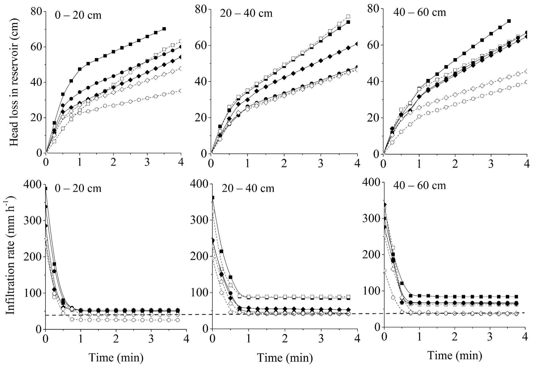
Soil infiltration is the process by which water on the soil surface penetrates the soil. The quantification of soil infiltrability is very important for determining the components of hydrological modeling, irrigation design, and many other processes [50]. The results of soil infiltration (Figure 5) show that there were some differences during the process of soil infiltration at different layers. The slope of the curve indicates the infiltration rate of the soil. As a whole, the lowest steady infiltration rate was 25.8 mm h–1 (MS2, 0–20 cm). In most cases, the steady infiltration rates were >40 mm h–1. These results are similar to those obtained by Ceballos [10] in a study on the soil water behavior of sandy soils under semiarid conditions in the Duero Basin. Ceballos [10] found significant relationships between the soil texture and steady infiltration rate. Typically, the rate of steady infiltration of the soil in which the sand content is >80% and the clay content is <10% is always >40 mm h–1. In this study, the initial infiltration rate of TS1 for the first layer was much higher than that of the other points measured. The steady infiltration rate of TS2 was the highest. The initial rate of infiltration of the 20–40 cm layer and the steady rate of infiltration of the top slope were higher than those of the middle and bottom slopes. The rate of initial infiltration and the steady infiltration rate of MS2 were the lowest in the 40–60 cm layer.
There are many factors that affect the soil infiltration characteristics, such as soil texture, particularly the content of sand; the gravel fraction and rock fragments in the soil; the soil use pattern; and the vegetation type [10,51,52]. The highest initial infiltration rate and steady infiltration rate were observed at the top of the slope (Figure 5). Field observations found almost no gravel or anthropogenic interference in the top slope soil. In the analysis of soil infiltration, the highest content of sand was observed in the plots with the highest initial infiltration rates and steady infiltration rates (TS1, TS2, and BS1), where the mean content of sand in these plots was 80.85%, 83.43%, and 84.42%, respectively (Table 1). The lowest initial infiltration rate and steady infiltration rate were found in plot MS2 (Figure 5), where the average contents of sand and clay were 75.80% and 12.15%, respectively (Table 1). The coarse pores of sand provide a natural condition for the production of preferential flow in the soil, which is conducive to the infiltration of water. Thus, higher initial infiltration rates and steady infiltration rates were related to a higher content of sand in this study. Similarly, a study by Vries and Chow [53] found that soil macropores were the primary reason for the rapid production of interflow. Under the same hydraulic conductivity, the water moved more quickly owing to the soil macropores, and the infiltration depth was deeper [53]. Meek [54] found that greater infiltration rates probably resulted from the flow of water through macropores in a study of infiltration rates as affected by an alfalfa (Medicago sativa) and no-till cotton (Gossypium hirsutum) cropping system.

3.3. Available Soil Water

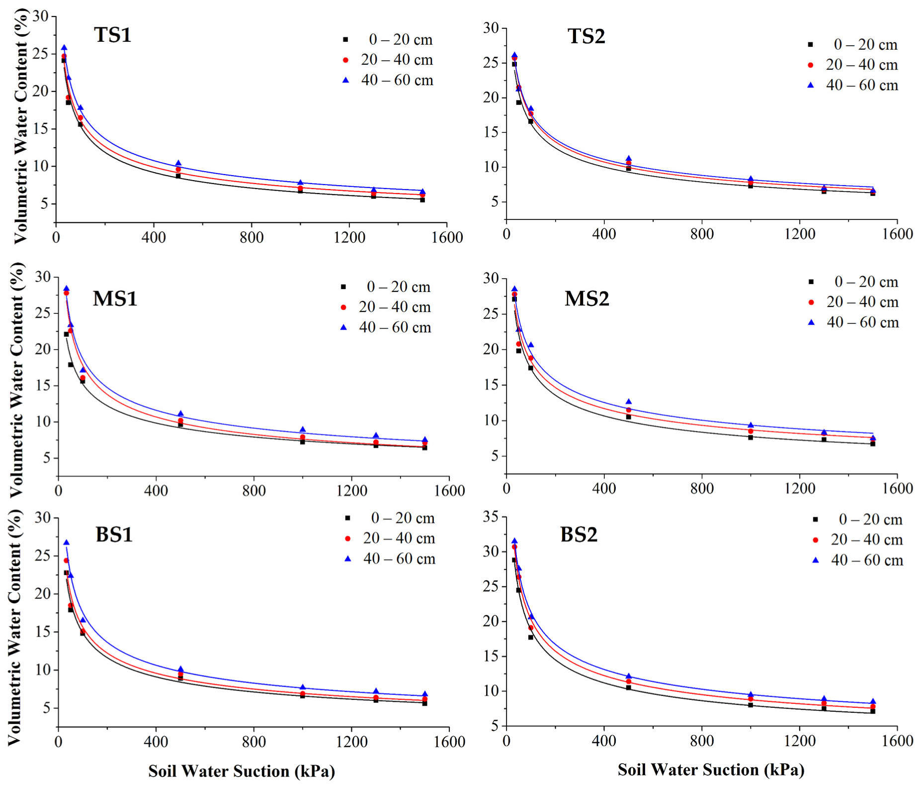
The soil water retention curve, which reflects the relationship between the soil moisture content and the energy and condition of the soil to retain water, is an important curve of soil water characteristics [55,56]. The fitted results are shown in Table 2 and Figure 6.
The soil water retention curve reflects the calculation of the water content at FC, WP, and AWC for the sampling sites (Table 2). The AWC increased from the TS to BS. The average FC was 25.81% with a variation coefficient of 10.50%. The WP was more variable, and varied by approximately 6.81%. The average AWC was 19.0%. These results are similar to those reported by Zhou [57], who showed that the WP of the northwest arid area of northwest China and the Tibetan Plateau was primarily between 5.5 and 8.3%, and the FC was < 32.0%. The AWC increased as the fraction of sand decreased and the fraction of clay increased. This phenomenon is supported by the research of Ceballos et al. [10] and Fares and Alva [58]. Ceballos et al. [10] obtained a highly significant correlation coefficient between the AWC and the clay fraction (R2 = 0.77; p = 0.005). The relationship between AWC and the soil particle composition, particularly the clay fraction, explains why a higher AWC was found in the 40–60 cm layer below the soil surface and at the BS (owing to the migration of fine soil particles) (Table 1). A highly significant correlation between the AWC and the OM content was obtained in some studies [10,59]. However, this relationship was not obvious in this study, owing to the low contents of soil OM at each sampling point.

3.4. Soil Water Retention Capacity

To estimate the soil water retention capacity of sandy soils under natural conditions, a soil water retention curve was obtained using Equation (2). The soil water retention curve reflects the soil water retention capacity. A higher curve indicates a stronger retention capacity, and a lower curve indicates a weaker retention capacity [43].
The soil water retention curve for the six sampling points is shown in Figure 6. The highest soil water retention capacity was in the 40–60 cm layer, where the decrease in the soil water content with the water potential was the slowest. The weakest soil water retention capacity was found in the 0–20 cm layer, where the decrease in the soil water content with the water potential was the fastest. Under the same suction conditions, the soil moisture content at the different layers of the soil varied. The 40–60 cm soil layer maintained the maximum amount of soil water. Correspondingly, the amount of soil water maintained by the 0–20 cm layer was the lowest. It is also apparent in Figure 6 that the soil water retention curves of MS1, MS2, and BS2 were higher than those of TS1, TS2, and BS1, which indicates that the water retention capacity of MS1, MS2, and BS2 was higher in the study area. This was primarily related to the lower soil hydraulic conductivity, and the lower contents of sand and higher contents of clay in MS1, MS2, and BS2 (Table 1). The soil texture is another factor that affects the soil water retention capacity [27,60,61,62,63]. A study by Franco-Vizcaíno [64] on the water regime in soils and plants along an aridity gradient in central Baja California showed that the soil water in sandy soils was depleted much more quickly than that in loamy soils.
A rainfall experiment was used to study the retention characteristics of soil water. The soil moisture was measured during and after rainfall. The mean soil moisture content was 12.24% at the beginning of rainfall. After 22.2 mm of rainfall in approximately 1 h, the soil moisture content reached its maximum and decreased with time. The mean increase in the soil moisture content was 199.12% at 1 h, which decreased to 79.64% 48 h later (Table 3). At 48 h after the end of the rainfall, the soil water contents of TS1, TS2, MS1, MS2, and BS1 were less than the corresponding soil water contents at field capacity, indicating that the soil lost water at a faster rate than that of the water supplied in these sites. However, the soil water content of BS2 was higher than the soil water content at FC, revealing that the soil water retention capacity of BS2 was higher than that of the other sampling points.
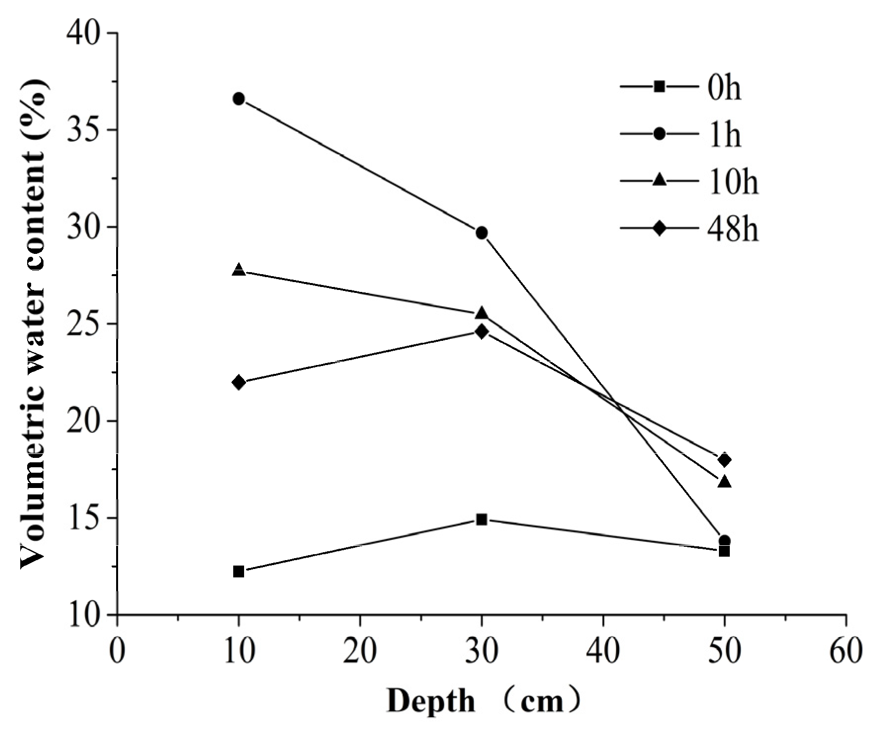
The soil water distribution pattern along the profile during the rainfall simulation experiment is shown in Figure 7. The water content of the whole profile ranged from 12.24% to 14.92% before the rainfall experiment, which was lower than the FC. One hour after the end of the experiment, the soil water content in the 0–20 and 20–40 cm layers below the soil surface exceeded the water content at FC, which increased to 36.61% and 29.70%, respectively. However, the 40–60 cm layer below the soil surface only showed small changes in the soil water content. At 48 h after the end of the rainfall, the soil water content of the 0–20 and 20–40 cm layers below the soil surface decreased to 21.99% and 24.62%, respectively. The relatively higher soil hydraulic conductivity of the 0–20 and 20–40 cm soil layers (Table 1) explained the faster flux of the wetting front at these layers. Similarly, the lower soil hydraulic conductivity of the 40–60 cm soil was the primary reason of the slower flux of the wetting front at this layer [10]. However, 48 h after the end of the rainfall, the soil water content of the whole profile was ≤FC, which reveals that the soil water retention capacity was low throughout the whole profile. During the experiment, the study area experienced a rainfall intensity of 22 mm in an hour. If the influence of temperature during this period is ignored, the rainfall would substantially increase the moisture content of the surface soil. In fact, owing to the high summer temperatures in this area and the sunny days after the rain, there is no doubt that a substantial amount of the surface water evaporated, which weakened the supplementary effect of rainfall on the soil water to some extent. Under the conditions of sufficient sunlight and strong solar radiation, with an increase in light intensity and sunshine hours, the evaporation of surface soil water will increase, which will further reduce the content of soil water. Therefore, during the experiment, particularly within 48 h after rainfall infiltration, the evaporation effect of soil water loss cannot be ignored. However, considering that the study area was located on a small hillside, the evaporation rates of all the measured points were considered almost the same, and the influence of soil water evaporation on the change in soil water content was almost the same. The soil water evaporation at the monitoring points was not measured during the experiment. The relationship between evaporation intensity and soil water loss will be studied in more detail in subsequent research.

4. Conclusions

This study examined the soil water behavior of sandy soils under semiarid conditions in the Shendong mining area (China). The values of soil moisture at different positions of the slope were in the following order: BS > MS > TS. The soil moisture of the first 20 cm of soil was the lowest, and the moisture levels increased with depth. These results can be explained by the distribution of the soil’s clay fraction, owing to its positive influence on the soil moisture in the case studied. In most cases, the steady state infiltration rates were >40 mm h–1. Owing to the higher sand content and soil macropores at the TS and 0–20 cm surface soil, the initial infiltration rate and steady infiltration rate were higher. The average AWC was 18.28%, which was consistent with the predominance of sandy textural fractions. The results of a soil water retention curve and a rainfall simulation experiment revealed a low soil water retention capacity throughout the whole profile. Several considerations on the soil water behavior of sandy soils have been reported in this study that will enable an understanding of the heterogeneity in soil water behavior in these arid ecosystems and provide data for optimal land management.

Author Contributions

Conceptualization, Y.L.; data curation, L.L.; formal analysis, Y.L.; funding acquisition, Y.L. and S.L.; investigation, Y.G.; project administration, Y.L. and S.L.; resources, L.L.; software, Y.G.; writing—original draft, Y.L.; writing—review and editing, L.L. All authors have read and agreed to the published version of the manuscript.

Funding

This research was funded by the Open Fund of State Key Laboratory of Water Resource Protection and Utilization in Coal Mining (No. WPUKFJJ2019-16), the Mine Ecological Restoration Engineering Research Center Open Fund of the Ministry of Education (No. KSSTXF202108), the Ordos Science & Technology Plan (No. 2021EEDSCXQDFZ010), the National Key Research and Development Program (No. 2016YFC0501107), and the National Natural Science Foundation of China (No. U1361214).

Informed Consent Statement

Not applicable.

Data Availability Statement

Not applicable.

Acknowledgments

The authors thank the Open Fund of State Key Laboratory of Water Resource Protection and Utilization in Coal Mining and the Anhui University of Science and Technology for their strong support in data use and funding. The authors also thank the reviewers for their constructive suggestions on the modification and improvement of the manuscript.

Conflicts of Interest

The authors declare no conflict of interest.

References

  1. Nash, M.S.; Wierenga, P.J.; Gutjahr, A. Time series analysis of soil moisture and rainfall along a line transect in arid rangeland. Soil Sci. 1991, 152, 189–198. [Google Scholar] [CrossRef]
  2. Liu, Y.; Lei, S.G.; Chen, X.Y.; Chen, M.; Zhang, X.Y.; Long, L.L. Disturbance mechanism of coal mining subsidence to typical plants in a semiarid area using O–J–I–P chlorophyll a fluorescence analysis. Photosynthetica 2020, 58, 1178–1187. [Google Scholar] [CrossRef]
  3. Rodriguez-Iturbe, I.; D’Odorico, P.; Porporato, A.; Ridolfi, L. On the spatial and temporal links between vegetation, climate, and soil moisture. Water Resour. Res. 1999, 35, 3709–3722. [Google Scholar] [CrossRef]
  4. Lei, S.G. Monitoring and analyzing the mining impacts on key environmental elements in desert area. J. China Coal Soc. 2010, 35, 1587–1588. [Google Scholar] [CrossRef]
  5. Lei, S.G.; Bian, Z.F. Research progress on the environment impacts from underground coal mining in arid western area of China. Acta Ecol. Sin. 2014, 34, 2837–2843. [Google Scholar] [CrossRef]
  6. Cai, D.; Xu, H. Extracting Soil Moisture from Landsat Imagery of Xiamen City Using a Spectral Feature Space Composed of Fractional Vegetation Cover and Land Surface Temperature. Remote Sens. Technol. Appl. 2011, 23, 278–283. Available online: http://www.rsta.ac.cn/EN/10.11873/j.issn.1004-0323.2008.3.278 (accessed on 25 January 2022).
  7. Wang, J.; Liang, J.; Li, Z.; Wu, W.; Yu, J.; Han, L. Assessment of Arid area Soil Moisture Status Based on Characteristics of Surface Temperature/vegetation Index Space. Chin. J. Soil Sci. 2014, 45, 39–46. [Google Scholar] [CrossRef]
  8. Jackson, T.; Mansfield, K.; Saafi, M.; Colman, T.; Romine, P. Measuring soil temperature and moisture using wireless MEMS sensors. Measurement 2008, 41, 381–390. [Google Scholar] [CrossRef]
  9. Chauhan, N.S.; Miller, S.; Ardanuy, P. Spaceborne soil moisture estimation at high resolution: A microwave-optical/IR synergistic approach. Int. J. Remote Sens. 2003, 24, 4599–4622. [Google Scholar] [CrossRef]
  10. Ceballos, A.; Martinez-Fernández, J.; Santos, F.; Alonso, P. Soil-water behaviour of sandy soils under semi-arid conditions in the Duero Basin (Spain). J. Arid Environ. 2002, 51, 501–519. [Google Scholar] [CrossRef]
  11. Zhang, Y.; Zhang, G.; Wang, Z. Influence of soil particle composition on soil moisture in loess profiles. Bull. Soil Water Conserv. 2009, 29, 6–15. [Google Scholar] [CrossRef]
  12. Chen, H. Environmental Soil Science; Science Press: Beijing, China, 2005; pp. 49–50. [Google Scholar]
  13. Vladimir, S.; Jan, H.; Martin, J.; Dusan, S. Soil structure and soil organic matter in water-stable aggregates under different application rates of biochar. Vietnam J. Earth Sci. 2018, 40, 97–108. [Google Scholar] [CrossRef] [Green Version]
  14. Bao, H.; Hou, L.; Liu, J.; Li, L. Experiment on process of soil water infiltration and redistribution under simulated rainfall. Trans. Chin. Soc. Agric. Eng. 2011, 27, 70–75. [Google Scholar] [CrossRef]
  15. Morbidelli, R.; Corradini, C.; Saltalippi, C.; Brocca, L. Initial soil water content as input to field-scale infiltration and surface runoff models. Water Resour. Manag. 2012, 26, 1793–1807. [Google Scholar] [CrossRef]
  16. Li, G.; Feng, Q.; Zhang, F.; Cheng, A. The soil infiltration characteristics of typical grassland in Babao River Basin of Qi-lian Mountain. Agric. Res. Arid Areas 2014, 32, 60–65. [Google Scholar] [CrossRef]
  17. Li, X. The partiele composition of several arid region soil of Gansu province and its effect on soil moisture constants. Gansu Nongye Daxue Xuebao 1993, 4, 376–379. [Google Scholar]
  18. Luo, Y.X.; Liu, R.T.; Zhang, J.; Chang, H.T. Soil particle composition, fractal dimension and their effects on soil properties following sand-binding revegetation within straw checkerboard in Tengger Desert, China. Chin. J. Appl. Ecol. 2019, 30, 525–535. [Google Scholar] [CrossRef]
  19. Mathur, M.; Sundaramoorthy, S. Patterns of herbaceous species richness and productivity along gradients of soil moisture and nutrients in the Indian Thar Desert. J. Arid Environ. 2016, 125, 80–87. [Google Scholar] [CrossRef]
  20. Tillman, F.D.; Wiele, S.M.; Pool, D.R. A comparison of estimates of basin-scale soil-moisture evapotranspiration and estimates of riparian groundwater evapotranspiration with implications for water budgets in the Verde Valley, Central Arizona, USA. J. Arid Environ. 2016, 124, 278–291. [Google Scholar] [CrossRef] [Green Version]
  21. Guo, Z. Soil water resource use limit in semi-arid loess hilly area. Yingyong Shengtai Xuebao 2010, 21, 3029–3035. [Google Scholar] [CrossRef]
  22. Dong, L.; Li, S.; Jiang, Q.; Zhang, R.Y.; Cai, J.J.; Wang, Y.L.; Ma, F. Soil moisture storage of different land use types in Ningxia semi-arid loess hilly area. J. Arid Land Environ. 2011, 25, 184–189. [Google Scholar]
  23. Zhang, Y.; Gan, Z.; Li, R.; Wang, R.; Li, N.; Zhao, M.; Du, L.; Guo, S.; Jiang, J.; Wang, Z. Litter production rates and soil moisture influences interannual variability in litter respiration in the semi-arid Loess Plateau, China. J. Arid Land Environ. 2016, 125, 43–51. [Google Scholar] [CrossRef]
  24. Cantón, Y.; Solé-Benet, A.; Domingo, F. Temporal and spatial patterns of soil moisture in semiarid badlands of SE Spain. J. Hydrol. 2004, 285, 199–214. [Google Scholar] [CrossRef]
  25. Fitzjohn, C.; Ternan, J.L.; Williams, A.G. Soil moisture variability in a semi-arid gully catchment: Implications for runoff and erosion control. Catena 1998, 32, 55–70. [Google Scholar] [CrossRef]
  26. Wang, Y. Spatial Distribution and Influence Factors of Dried Soil Layers Across the Loess Plateau. Ph.D. Thesis, University of Chinese Academy of Sciences, Beijing, China, 2010. [Google Scholar]
  27. Fayos, C.B. The roles of texture and structure in the water retention capacity of burnt Mediterranean soils with varying rainfall. Catena 1997, 31, 219–236. [Google Scholar] [CrossRef]
  28. Famiglietti, J.S.; Rudnicki, J.W.; Rodell, M. Variability in surface moisture content along a hillslope transect: Rattlesnake Hill, Texas. J. Hydrol. 1998, 210, 259–281. [Google Scholar] [CrossRef] [Green Version]
  29. Gu, Y. Analysis on flora of soil and water conservation plants in Shendong mining area. Bull. Soil Water Conserv. 2016, 36, 260–263. [Google Scholar] [CrossRef]
  30. Zhou, R. Influence of Coal Mining Subsidence on Properties of Sandy Soil in Erdos. Master’s Thesis, Inner Mongolia Agriculture University, Hohhot, China, 2008. [Google Scholar]
  31. Gan, L.; Ma, R.; Peng, Y.; Peng, X.; Mo, C.; Rainer, H. The effect of different grazing intensities on spatial distribution of soil water under Leymus chinensis and Stipa grands grassland. Ecol. Environ. Sci. 2015, 24, 1274–1279. [Google Scholar] [CrossRef]
  32. Reynolds, W.D.; Elrick, D.E.; Topp, G.C. A reexamination of the constant head well permeameter method for measuring saturated hydraulic conductivity above the water table1. Soil Sci. 1983, 136, 250. [Google Scholar] [CrossRef]
  33. Kuráž, V. Soil properties and water regime of reclaimed surface dumps in the North Bohemian brown-coal region—a field study. Waste Manag. 2001, 21, 147–151. [Google Scholar] [CrossRef]
  34. Celik, I.; Gunal, H.; Budak, M.; Akpinar, C. Effects of long-term organic and mineral fertilizers on bulk density and penetration resistance in semi-arid Mediterranean soil conditions. Geoderma 2010, 160, 236–243. [Google Scholar] [CrossRef]
  35. Ahmad, N.; Hassan, F.; Qadir, G. Effect of subsurface soil compaction and improvement measures on soil properties. Int. J. Agric. Biol. 2007, 9, 509–513. [Google Scholar]
  36. Green, R.E.; Ahuja, L.R.; Chong, S.K. Hydraulic conductivity, diffusivity, and sorptivity of unsaturated soils: Field methods. Methods Soil Anal. Part 1 Phys. Mineral. Methods 1986, 5, 771–798. [Google Scholar] [CrossRef]
  37. Holliday, V.T. Methods of soil analysis, part 1, physical and mineralogical methods (2nd edition), A. Klute, Ed. 1986, American Society of Agronomy, Agronomy Monographs 9(1), Madison, Wisconsin. Geoarchaeology 1990, 5, 87–89. [Google Scholar] [CrossRef]
  38. Zhang, S.; Shao, M. Spatial variability of soil moisture content and soil organic matter content in Oasis Marginal Zone. Arid Zone Res. 2014, 31, 812–818. [Google Scholar] [CrossRef]
  39. Carter, D.L.; Mortland, M.M.; Kemper, W.D. “Specific surface”—Methods of Soil Analysis: Part 1. Phys. Mineral. Methods 1986, 5, 413–423. [Google Scholar]
  40. Gee, G.W.; Or, D. Particle-size analysis. In Methods of Soil Analysis; Soil Science Society of America: Madison, WI, USA, 2002; pp. 255–293. [Google Scholar]
  41. Gee, G.W.; Bauder, J.W. Particle-size Analysis. In Methods of Soil Analysis: Part I—Physical and Mineralogical Methods; Campbell, G.S., Jackson, R.D., Mortland, M.M., Nielsen, D.R., Klute, A., Eds.; American Society of Agronomy: Madison, WI, USA, 1986; pp. 383–411. [Google Scholar]
  42. Nelson, D.W.; Sommers, L.E. Total carbon, organic carbon, and organic matter. In Methods of Soil Analysis: Part 3. Chemical Methods, SSSA Book Series No. 5; SSSA and ASA: Madison, WI, USA, 1996; pp. 961–1010. [Google Scholar] [CrossRef]
  43. Zhang, Q.; Sun, X.; Yu, W. Studies on soil water characteristic curves and infiltration capability of Maowusu sandy soil. For. Res. 2004, 17, 9–14. [Google Scholar] [CrossRef]
  44. Liu, J.; Xu, S.; Liu, H. A review of development in estimating soil water retention characteristics from soil data. J. Hydraul. Eng. 2004, 2, 68–76. [Google Scholar] [CrossRef]
  45. Wang, Q.; Zeng, Z.; Zhong, M. Soil moisture alters the response of soil organic carbon mineralization to litter addition. Ecosystems 2016, 19, 450–460. [Google Scholar] [CrossRef]
  46. Liu, C.L.; Shao, M.A.; Zhang, X.C.; Li, S.Q. Study on Soil Moisture Spatial Variability of Degraded Slope in Shenmu Wind-Water Erosion Crisscross Region. J. Soil Water Conserv. 2005, 33, 132–135. [Google Scholar]
  47. Liu, C.; Shao, M. Spatial variation of saturated hydraulic conductivity and soil water of the surface layer of a slope on the Loess Plateau. Sci. Soil Water Conserv. 2009, 7, 13–18. [Google Scholar] [CrossRef]
  48. Bian, Z.; Lei, S.; Chang, L.; Zhang, R. Affecting factors analysis of soil moisture for arid mining area based on TM images. J. China Coal Soc. 2009, 34, 520–525. [Google Scholar] [CrossRef]
  49. Bi, Y.; Zou, H.; Peng, C.; Shi, L. Effects of mining subsidence on soil water movement in sandy area. J. China Coal Soc. 2014, 39, 490–496. [Google Scholar] [CrossRef]
  50. Mao, L.; Bralts, V.F.; Pan, Y.; Liu, H.; Lei, T. Methods for measuring soil infiltration: State of the art. Int. J. Agric. Biol 2008, 1, 22–30. [Google Scholar] [CrossRef]
  51. Kidron, G.J.; Yaalon, D.H.; Vonshak, A. Two causes for runoff initiation on microbiotic crusts: Hydrophobicity and pore clogging. Soil Sci. 1999, 164, 18–27. [Google Scholar] [CrossRef]
  52. Poesen, J.; Ingelmo Sanchez, F.; Mucher, H. The hydrological response of soil surfaces to rainfall as affected by cover and position of rock fragments in the top layer. Earth Surf. Process. Landf. 1990, 15, 653–671. [Google Scholar] [CrossRef]
  53. De Vries, J.; Chow, T.L. Hydrologic behavior of a forested mountain soil in coastal British Columbia. Water Resour. Res. 1978, 14, 935–942. [Google Scholar] [CrossRef]
  54. Meek, B.D.; Detar, W.R.; Rechel, E.R.; Carter, L.M.; Rolph, D. Infiltration rate as affected by an alfalfa and no-till cotton cropping system. Soil Sci. Soc. Am. J. 1990, 54, 505–508. [Google Scholar] [CrossRef] [Green Version]
  55. Jury, W.A.; Horton, R. Soil Physics; John Wiley & Sons: Hoboken, NJ, USA, 2004. [Google Scholar]
  56. Wang, H.; Yang, W.; Zhang, X. Soil water characteristics of woodlands on slope in loess areas in West Shaanxi. Agric. Res. Arid Areas 2005, 23, 147–150. [Google Scholar] [CrossRef]
  57. Zhou, W. A Study on Available Water Capacity of Main Soil Types in China Based on GIS. Master Thesis, Nanjing Agricultural University, Nanjing, China, 2003. [Google Scholar] [CrossRef]
  58. Fares, A.; Alva, A.K. Soil water components based on capacitance probes in a sandy soil. Soil Sci. Soc. Am. J. 2000, 64, 311–318. [Google Scholar] [CrossRef]
  59. Ingelmo, F.; Cuadrado, S.; Ibanez, A.; Hernandez, J. Hydric properties of some Spanish soils in relation to their rock fragment content: Implications for runoff and vegetation. Catena 1994, 23, 73–85. [Google Scholar] [CrossRef]
  60. da Costa, A.; Albuquerque, J.A.; da Costa, A.; Pertile, P.; da Silva, F.R. Water retention and availability in soils of the State of Santa Catarina-Brazil: Effect of textural classes, soil classes and lithology. Rev. Bras. Cienc. Solo 2013, 37, 1535–1548. [Google Scholar] [CrossRef] [Green Version]
  61. Ren, L.; Huang, M.; Fan, J. Study on water retention capacity for drained soils with different textural layering. Nongye Gongcheng Xuebao/Trans. Chin. Soc. Agric. Eng. 2013, 29, 105–111. [Google Scholar] [CrossRef]
  62. Liu, Y.; Lu, J.; Wang, R.; Han, X.; Chen, Y. Soil structure, nutrient accumulation and water retention character in eroded hilly red soil after virescence. J. Soil Water Conserv. 2000, 14, 79–82. [Google Scholar] [CrossRef]
  63. Su, Y.; Zhu, J.; Wang, P.; Wang, D.B.; Lin, Y. Research progress on soil water holding capacity. Chin. Agric. Sci. Bull. 2013, 29, 140–145. [Google Scholar] [CrossRef]
  64. Franco-Vizcaíno, E. Water regime in soils and plants along an aridity gradient in central Baja California, Mexico. J. Arid Environ. 1994, 27, 309–323. [Google Scholar] [CrossRef]
Figure 1. The locations of the study region: (a) the geographic location of Inner Mongolia; (b) the geographic location of Bulianta; and (c) the sampling sites and altitude of the study region.
Water 14 02159 g001
Figure 2. Spatial distribution of soil moisture in the study area.
Water 14 02159 g002
Figure 3. Soil texture classification diagram of sampling points (black solid points).
Water 14 02159 g003
Figure 4. Relationships between soil moisture and soil texture, bulk density, organic matter content, and hydraulic conductivity.
Water 14 02159 g004
Figure 5. Soil infiltration processes and infiltration rates of study sites. ( Water 14 02159 i001) TS1; ( Water 14 02159 i002) TS2; ( Water 14 02159 i003) MS1; ( Water 14 02159 i004) MS2; ( Water 14 02159 i005) BS1; and ( Water 14 02159 i006) BS2.
Water 14 02159 g005
Figure 6. Soil water retention curve. The black point fitted line is the surface 0–20 cm soil water conservation curve, the red point fitted line is the 20–40 cm soil water conservation curve, and the blue point fitted line is the 40–60 cm soil water conservation curve.
Water 14 02159 g006
Figure 7. Soil water distribution pattern along the profile during the rainfall simulation experiment.
Water 14 02159 g007
Table 1. Physical properties of the sampling plot soil.
PlotLayer
(cm)
Texture Classification
(USDA)
Sand
(%)
Silt
(%)
Clay (%)OM (%)BD
(g cm–3)
Ksat
(cm h–1)
TS10–20Loamy Sand83.299.836.880.521.6838.67
20–40Loamy Sand80.159.7110.140.311.6714.97
40–60Sandy Loam79.108.6812.230.321.7453.33
TS20–20Loamy Sand85.1611.123.730.541.6947.33
20–40Loamy Sand84.1010.255.660.411.7654.00
40–60Loamy Sand81.029.879.120.391.6915.27
MS10–20Loamy Sand80.209.4810.330.581.6521.27
20–40Loamy Sand79.649.1311.240.461.665.79
40–60Loamy Sand79.679.1211.220.451.745.01
MS20–20Sandy Loam75.9613.8910.160.561.667.53
20–40Sandy Loam75.5411.1113.350.531.5110.32
40–60Sandy Loam75.8911.1212.990.341.6116.81
BS10–20Loamy Sand84.718.596.700.501.8018.60
20–40Loamy Sand84.559.086.380.291.7915.51
40–60Loamy Sand84.017.668.330.321.7014.55
BS20–20Sandy Loam78.979.5411.50.601.5911.97
20–40Sandy Loam78.488.9112.610.541.7310.44
40–60Sandy Loam78.598.7912.630.421.665.55
Aver. Loamy Sand80.509.779.730.451.6920.38
SD 3.161.392.850.100.0716.29
CV (%) 3.9214.2229.3222.854.2479.91
Table 2. Soil water retention curve, water content at field capacity, water content at wilting point, and available capacity of the sampling sites.
PlotLayer
(cm)
Soil Water Retention CurveCorrelationFC
(%)
WP
(%)
AWC
(%)
TS10−20y = 84.79x − 0.3710.98923.175.6217.55
20−40y = 81.67x − 0.3520.98823.856.2217.63
40−60y = 86.85x − 0.3480.99725.726.8218.90
TS20−20y = 80.89x − 0.3480.98823.966.3517.61
20−40y = 85.35x − 0.3460.99625.466.7918.67
40−60y = 82.54x − 0.3340.98924.796.6718.12
MS10−20y = 64.64x − 0.3140.99121.566.5015.06
20−40y = 96.93x − 0.3680.98726.776.5720.20
40−60y = 91.34x − 0.3440.98827.437.3820.05
MS20−20y = 86.40x − 0.3490.97325.506.7318.77
20−40y = 82.14x − 0.3250.97526.377.6318.74
40−60y = 85.19x − 0.3200.98327.838.2019.63
BS10−20y = 75.74x − 0.3540.99121.975.6916.28
20−40y = 79.35x − 0.3530.98223.096.0017.09
40−60y = 92.41x − 0.3610.99526.726.7419.98
BS20−20y = 104.90x − 0.3730.99628.456.8621.59
20−40y = 108.52x − 0.3640.99530.397.5822.81
40−60y = 107.11x − 0.3500.98231.508.2823.22
Average 25.816.8119.00
CV (%) 10.5011.1211.16
Table 3. Temporal changes in 0–20 cm soil moisture at the rainfall application plots (θ, volumetric soil moisture content, %).
Plot0 h1 h10 h48 h
TS18.7933.8522.115.77
TS29.5735.3827.17517.94
MS114.7636.73330.5620.41
MS214.1138.0529.1922.15
BS110.6937.4124.818.43
BS215.5138.2232.4529.21
AVERAGE12.238336.6071727.712521.985
CV (%)21.614.2412.5922.21
Publisher’s Note: MDPI stays neutral with regard to jurisdictional claims in published maps and institutional affiliations.