
Normal Pressure Shale Gas Preservation Conditions in the Transition Zone of the Southeast Basin Margin of Sichuan Basin


Abstract
:1. Introduction
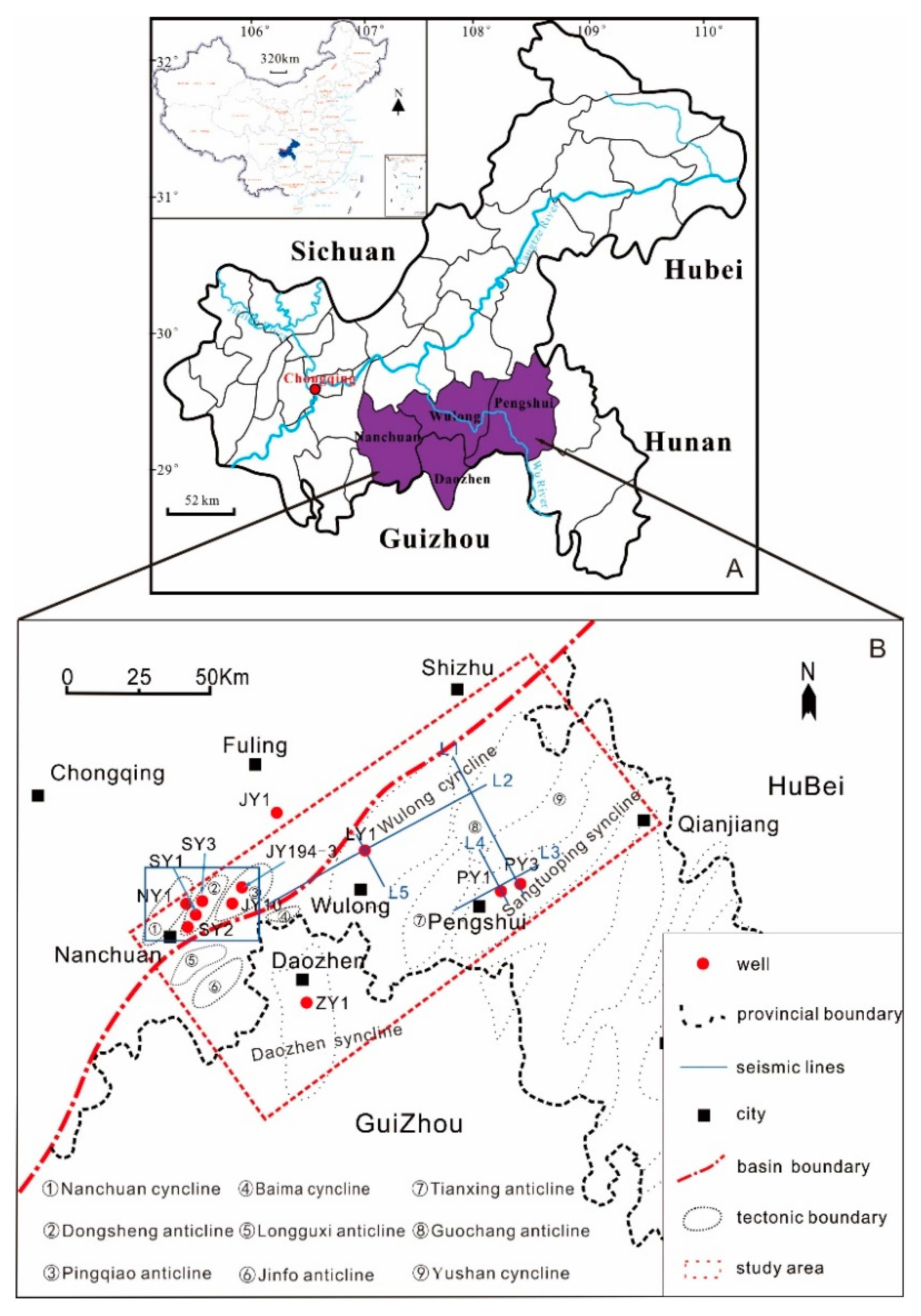
2. Geological Setting
3. Data and Method
3.1. Data
3.2. Methodology
4. Results
4.1. Well Data Analysis
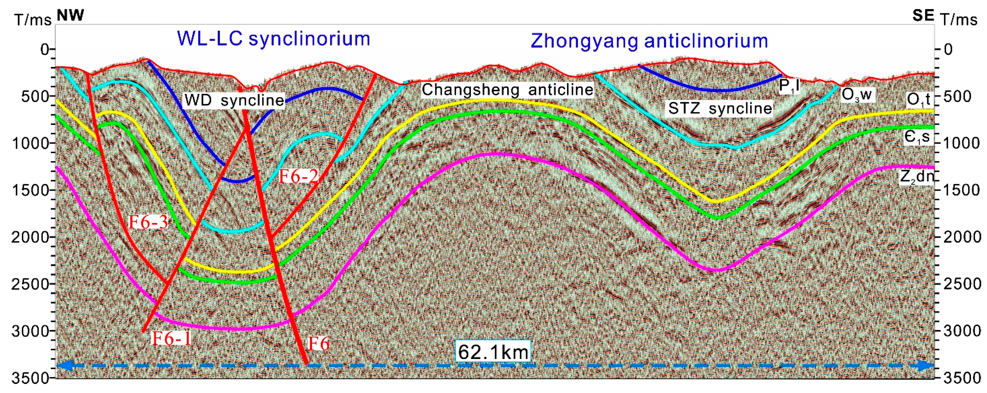
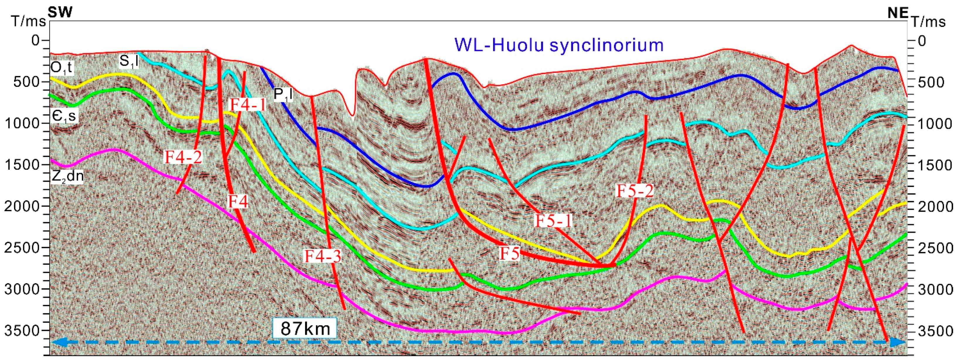
4.2. Seismic Interpretation
4.2.1. Fault Characteristic
4.2.2. Fold Characteristic
5. Discussion
5.1. Impact on Shale Gas Preservation Conditions
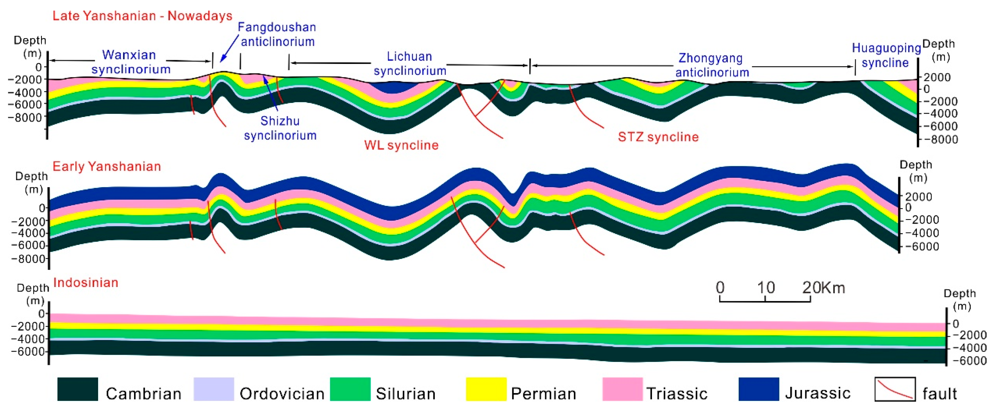
5.1.1. Tectonic Condition
5.1.2. Closure Condition
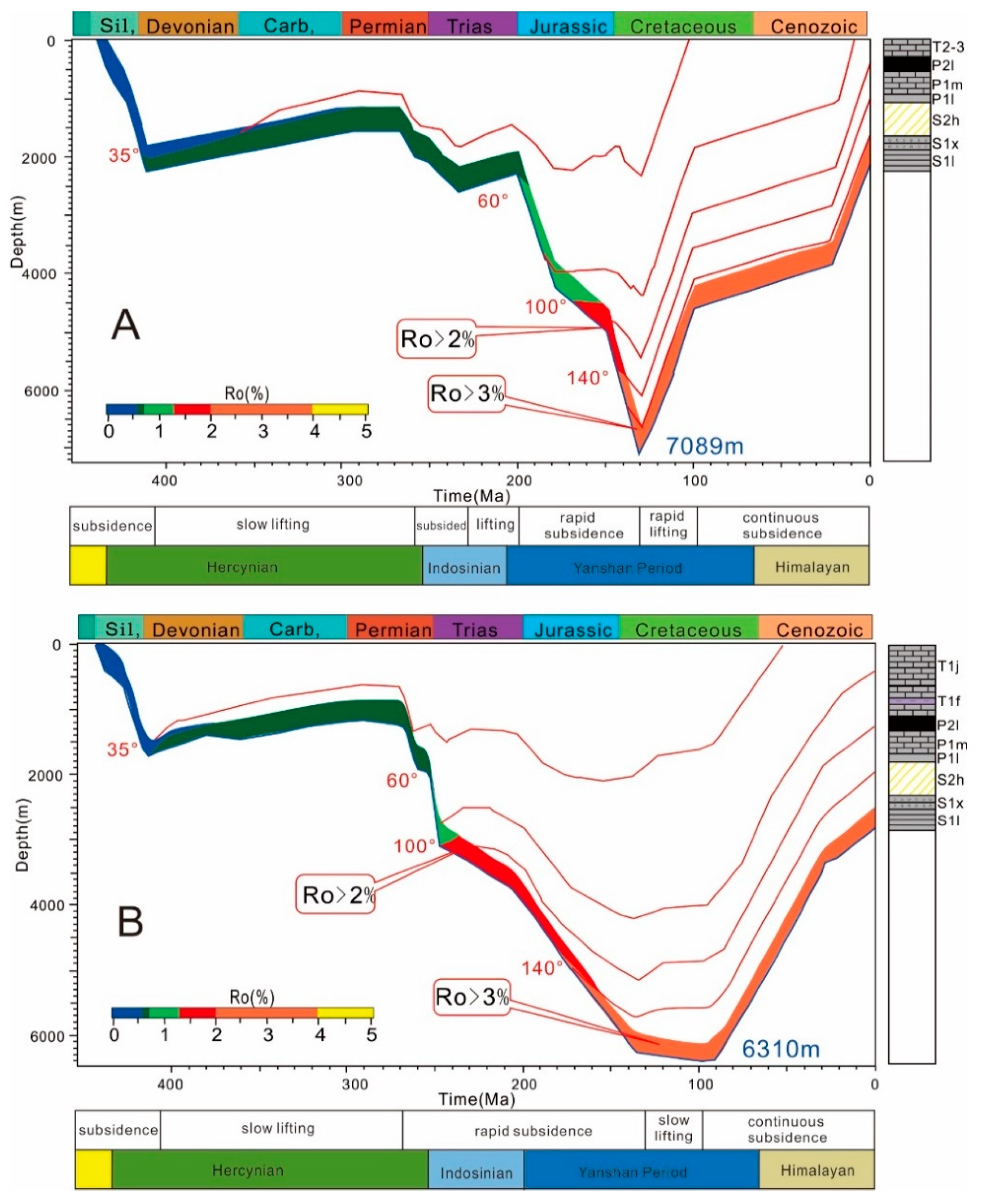
5.1.3. Formation Mechanism of Nature Pressure Shale Gas
5.2. Enrichment Model of Nature Pressure Shale Gas
6. Summary and Conclusions
Author Contributions
Funding
Data Availability Statement
Acknowledgments
Conflicts of Interest
References
- Ma, X.H. A golden era for natural gas development in the Sichuan Basin. Nat. Gas Ind. 2017, 4, 163–173. [Google Scholar] [CrossRef]
- Zou, C.N.; Yang, Z.; Sun, S.; Zhao, Q.; Bai, W.; Liu, H.; Pan, S.; Wu, S.; Yuan, Y. Exploring petroleum inside source kitchen: Shale oil and gas in the Sichuan Basin. Sci. China Earth Sci. 2020, 63, 934–953. [Google Scholar] [CrossRef]
- Zhai, G.; Wang, Y.; Bao, S.; Guo, T.; Zhou, Z.; Chen, X.; Wang, J. Major factors controlling the accumulation and high productivity of marine shale gas and prospect forecast in southern China. Earth Sci. 2017, 42, 1057–1068. [Google Scholar]
- Guo, X.S. Rules of two-factors enrichment for marine shale gas in southern China Understanding from the Longmaxi formation shale gas in The Sichuan basin and its surrounding area. Acta Geol. Sin. 2014, 88, 1209–1218. [Google Scholar]
- Thanh, H.V.; Sugai, Y.; Nguele, R.; Sasaki, K. Integrated workflow in 3D geological model construction for evaluation of CO2 storage capacity of a fractured basement reservoir in Cuu Long Basin, Vietnam. Int. J. Greenh. Gas Control. 2019, 90, 102826. [Google Scholar] [CrossRef]
- Vo Thanh, H.; Sugai, Y.; Sasaki, K. Impact of a new geological modelling method on the enhancement of the CO2 storage assessment of E sequence of Nam Vang field, offshore Vietnam. Energy Sources Part A Recovery Util. Environ. Eff. 2020, 42, 1499–1512. [Google Scholar] [CrossRef]
- Jin, Z.; Cai, L. Exploration prospects problems, and strategies of marine oil and gas in China. Oil Gas Geol. 2006, 27, 722–730. [Google Scholar]
- Fang, Z. Challenges and countermeasures for exploration and development of normal pressure shale gas in southern China. Reserv. Eval. Dev. 2019, 9, 1–13. [Google Scholar]
- Nie, H.K.; He, Z.L.; Liu, G. Status and direction of shale gas exploration and development in China. J. China Univ. Min. Technol. 2020, 49, 13–35. [Google Scholar]
- Ran, T.; Tan, X.; Chen, H.; Wang, J.; Xue, W.; Chen, Q.; Zeng, C.; Chen, C. Geological characteristics of shale gas accumulation in the Lower Silurian Longmaxi Formation in southeastern Chongqing. Pet. Geol. Recovery 2017, 24, 17–26. [Google Scholar]
- Pan, R.F.; Li, X.T.; Jin, J.J.; Zhu, Z.Z.; Meng, J.H. Heterogeneity characteristics and controlling factors of normal-pressure shale gas reservoirs in the basin-margin transition zone of SE Chongqing. Nat. Gas Ind. 2018, 38, 26–36. [Google Scholar]
- Yuan, Y.S.; Fang, Z.X.; He, X.P.; Peng, Y.M.; Long, S.X. Normal pressure formation mechanism of Longmaxi shale gas in Pengshui and its adjacent areas. Reserv. Eval. Dev. 2020, 10, 9r16. [Google Scholar]
- Nie, H.K.; Wang, H.; He, Z.L.; Wang, R.; Zhang, P.; Peng, Y.M. Formation mechanism, distribution and exploration prospect of normal pressure shale gas reservoir: A case study of Wufeng formation-Longmaxi formation in The Sichuan basin and its periphery. Acta Pet. Sin. 2019, 40, 131–143, 164. [Google Scholar]
- He, X.P.; Gao, Y.Q.; Tang, X.; Zhang, P.; He, G. Analysis of major factors controlling the accumulation in normal pressure shale gas in the southeast of Chongqing. Nat. Gas Geosci. 2017, 28, 654–664. [Google Scholar]
- Fang, Z.X.; He, X.P. Formation and evolution of shale gas in the Wulong slanting normal pressure in southeastern Chongqing. Oil Gas Geol. 2016, 37, 819–827. [Google Scholar]
- He, Z.L.; Nie, H.K.; Zhang, Y. The main factors of shale gas enrichment of Ordovician Wufeng formation-Silurian Longmaxi formation in the The Sichuan basin and its adjacent areas. Earth Sci. Front. 2016, 23, 8–17. [Google Scholar]
- Peng, Y.M.; Long, S.X.; He, X.P.; Tang, J.; Nie, H.K.; Gao, Y.M.; Xue, G.; Fan, Y.; Liu, Y. Characteristics of normal-pressure shale gas reservoirs and evaluation of its favorable areas in Pengshui. Reserv. Eval. Dev. 2020, 10, 12–19. [Google Scholar]
- He, Z.L.; Hu, Z.Q.; Nie, H.K.; Li, S.J.; Xu, J. Characterization of shale gas enrichment in the Wufeng-Longmaxi formation in the The Sichuan Basin and its evaluation of geological construction-transformation evolution sequence. Nat. Gas Geosci. 2017, 28, 724–733. [Google Scholar] [CrossRef]
- He, G.S.; He, X.P.; Gao, Y.Q.; Wan, J.; Zhang, P.; Zhang, Y.; Gao, H. Enrichment model of normal-pressure shale gas in the Jinfo slope of the basin-margin transition zone in Southeast Chongqing. Nat. Gas Ind. 2020, 40, 50–60. [Google Scholar]
- Sun, M.D.; Yu, B.S.; Li, J.; Cao, X.M.; Xia, W. Features and Major Controlling Factors of Longmaxi Shale Reservoir in Southeastern Chongqing. Spec. Oil Gas Reserv. 2014, 21, 63–66. [Google Scholar]
- Nie, H.; Jin, Z.; Ma, X.; Liu, Z.; Lin, T.; Yang, Z. Graptolites zone and sedimentary characteristics of upper Ordovivian Wufeng formation-lower Silurian Longmaxi formation in The Sichuan basin and its adjacent areas. Acta Petrolei Sin. 2017, 38, 160–174. [Google Scholar]
- He, X.P.; Zhang, P.; Fang, D.Z.; Mei, J.; He, G.; Lu, B. Production characteristics of normal pressure shale gasin Pengshui-Wulong area, southeast Chongqing. Pet. Geol. Recovery Effic. 2018, 25, 72–79. [Google Scholar]
- He, X.P.; Wang, Y.H.; Wang, Y.Q.; Zhang, L.; Wang, K.; Gao, Y.; Liu, M. Exploration practices of normal-pressure shale gas in the marginal transition zone of the southeast The Sichuan Basin. China Pet. Explor. 2020, 25, 126–136. [Google Scholar]
- Cai, Z.R.; Xia, B.; Huang, Q.; Wan, Z. Comparative study of the tectonic setting on the formation and preservation of Paleozoic shale gas between the upper Yangtze and the lower Yangtze platforms. Nat. Gas Geosci. 2015, 26, 1446–1454. [Google Scholar]
- Li, S.J.; Li, Y.; He, Z. Differential deformation on two sides of Qiyueshan Fault along the eastern margin of The Sichuan Basin, China, and its influence on shale gas preservation. Mar. Pet. Geol. 2020, 121, 104602. [Google Scholar] [CrossRef]
- Zhang, J.C.; Nie, H.K.; Xu, B. Geological Condition of Shale Gas Accumulation in The Sichuan Basin. Nat. Gas Ind. 2008, 28, 151–156. [Google Scholar]
- Powley, D.E. Pressures and hydrogeology in petroleum basins. Earth Sci. Rev. 1990, 79, 215–226. [Google Scholar] [CrossRef]
- Zhao, W.; Jing, T.; Wu, B.; Zhou, Y.; Xiong, X. Controlling mechanism of faults on the preservation conditions of shale gas: A case study of Wufeng-Longmaxi Formation in Southeast Chongqing. Gas Geosci. 2018, 29, 1333–1344. [Google Scholar]
- Dong, D.; Wang, Y.; Li, X.; Zou, C.; Guan, Q.; Zhang, C.; Huang, J.; Wang, S.; Wang, H.; Liu, H.; et al. Breakthrough and prospect of shale gas exploration and development in China. Nat. Gas Ind. 2016, 36, 19–32. [Google Scholar] [CrossRef] [Green Version]
- Guo, T.L. Evaluation of highly thermally mature shale-gas reservoirs in complex structural parts of the The Sichuan Basin. J. Earth Sci. 2013, 24, 863–873. [Google Scholar] [CrossRef]


| Characteristics | Value |
|---|---|
| Seismic type | 3D |
| Sample rate | 2 ms |
| Group interval | 25 m |
| Shooting interval | 50 m |
| Area | 168 km2 |
| Seismic Line | Structural Location | Direction | Total Length (km) | Total L Shots |
|---|---|---|---|---|
| L1 | WL-PS | NW-SE | 56.11 | 815 |
| L2 | WL | NE-SW | 87.3 | 1708 |
| L3 | PS | NE-SW | 32.61 | 559 |
| L4 | PS | NW-SE | 20.48 | 391 |
| L5 | WL | NE-SW | 16.2 | 370 |
| Well | Structural Position | Type | Total Depth (m) | Pressure Type |
|---|---|---|---|---|
| NY1 | Nanchuan cyncline | Vertical well | 4456 | overpressure |
| SY1 | Dongsheng anticline | Horizontal well | 3507 | overpressure |
| SY2 | Dongsheng anticline | Horizontal well | 4300 | overpressure |
| SY3 | Dongsheng anticline | Horizontal well | 5966 | overpressure |
| JY194-3 | Pingqiao slope | Horizontal well | 2723 | overpressure |
| JY10 | Pingqiao slope | Horizontal well | 3441 | normal pressure |
| LY1 | Wulong cyncline | Horizontal well | 4328 | normal pressure |
| LY2 | Wulong cyncline | Horizontal well | 4563 | normal pressure |
| PY1 | Sangtuoping cyncline | Horizontal well | 2208 | normal pressure |
| PY3 | Sangtuoping cyncline | Horizontal well | - | normal pressure |
| ZY1 | Daozhen cyncline | Horizontal well | - | normal pressure |
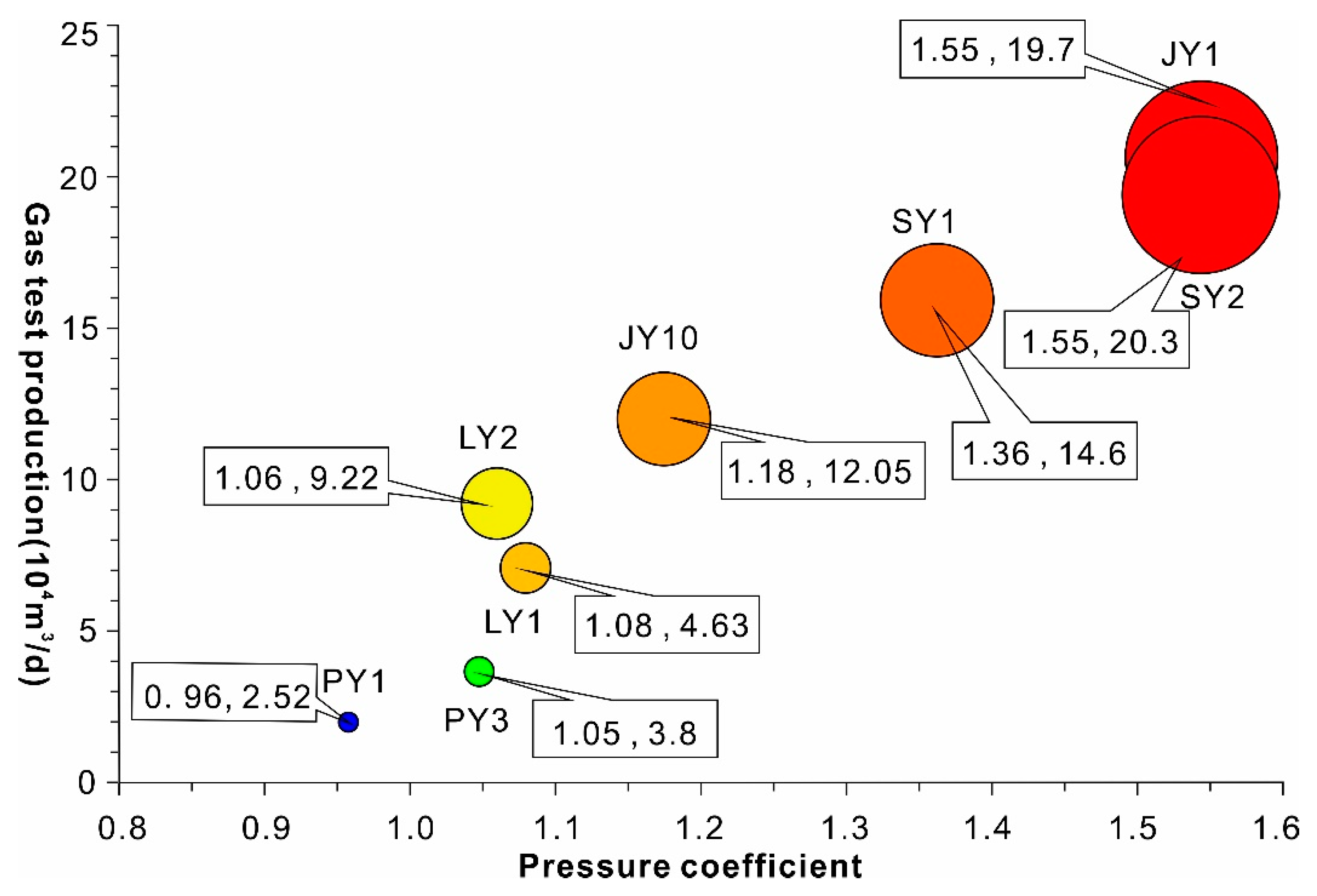
| Well | Tectonic Style | Fault/Denudation Boundary Distance (km) | Buried Depth (m) | Pressure Coefficient | TOC | Initial Production 104 m3/d |
|---|---|---|---|---|---|---|
| NY1 | Fault nose | No | 4411 | 1.35 | 3.09 | — |
| SY1 | Anticline | No | 3476 | 1.36 | 3.1 | 14.6 |
| SY2 | Anticline | Fault 3.4 | 2985 | 1.55 | 3.15 | 19.7 |
| SY3 | Anticline | Fault 2.7 | 4134 | 1.32 | 3.2 | 16.2 |
| JY194-3 | Slope | No | 2705 | 1.3 | 3.25 | 34.3 |
| JY10 | Slope | Fault 4.8 | 3404 | 1.18 | 3.19 | 12.05 |
| PY1 | Wide gentle syncline | Erosion 5.9 | 2160 | 0.96 | 3.22 | 2.52 |
| PY3 | Synclinal nucleus | Erosion 8.1 | 2809 | 1.05 | 3.28 | 3.8 |
| LY1 | Wide gentle syncline | Fault 2.1 | 2832 | 1.08 | 5.37 | 6.5 |
| LY2 | Wide gentle syncline | No | 2500 | 1.06 | 4.26 | 9.22 |
| ZY1 | slope | Erosion 2.8 | 595 | 1.18 | 2.88 | — |
| Fault | Type | Grade | Strike | Dip | Faulted Stratum | Fault Distance (m) | Length (km) |
|---|---|---|---|---|---|---|---|
| F1 | Reverse fault | I | SW-NE | E | Sinian | 3000 | - |
| F2 | Reverse fault | II | SW-NE | E | Sinian-P | 242–659 | 23.2 |
| F3 | Reverse fault | II | W-N | SE | Sinian-P | 1200–2100 | 40 |
| F4 | Reverse fault | II | SW-NE | SE | basement | 450–550 | 88.6 |
| F5 | Reverse fault | II | S-N | E | Sinian | 180 | 23.2 |
| F6 | Reverse fault | II | S-N | E | Sinian | 1600 | 48.6 |
Publisher’s Note: MDPI stays neutral with regard to jurisdictional claims in published maps and institutional affiliations. |
© 2022 by the authors. Licensee MDPI, Basel, Switzerland. This article is an open access article distributed under the terms and conditions of the Creative Commons Attribution (CC BY) license (https://creativecommons.org/licenses/by/4.0/).
Share and Cite
Liu, Y.; Jin, J.; Pan, R.; Li, X.; Zhu, Z.; Xu, L. Normal Pressure Shale Gas Preservation Conditions in the Transition Zone of the Southeast Basin Margin of Sichuan Basin. Water 2022, 14, 1562. https://doi.org/10.3390/w14101562
Liu Y, Jin J, Pan R, Li X, Zhu Z, Xu L. Normal Pressure Shale Gas Preservation Conditions in the Transition Zone of the Southeast Basin Margin of Sichuan Basin. Water. 2022; 14(10):1562. https://doi.org/10.3390/w14101562
Chicago/Turabian StyleLiu, Yisheng, Jineng Jin, Renfang Pan, Xiaotian Li, Zhengping Zhu, and Lingling Xu. 2022. "Normal Pressure Shale Gas Preservation Conditions in the Transition Zone of the Southeast Basin Margin of Sichuan Basin" Water 14, no. 10: 1562. https://doi.org/10.3390/w14101562
APA StyleLiu, Y., Jin, J., Pan, R., Li, X., Zhu, Z., & Xu, L. (2022). Normal Pressure Shale Gas Preservation Conditions in the Transition Zone of the Southeast Basin Margin of Sichuan Basin. Water, 14(10), 1562. https://doi.org/10.3390/w14101562