
Trend and Attribution Analysis of Runoff Changes in the Weihe River Basin in the Last 50 Years


Abstract
:1. Introduction
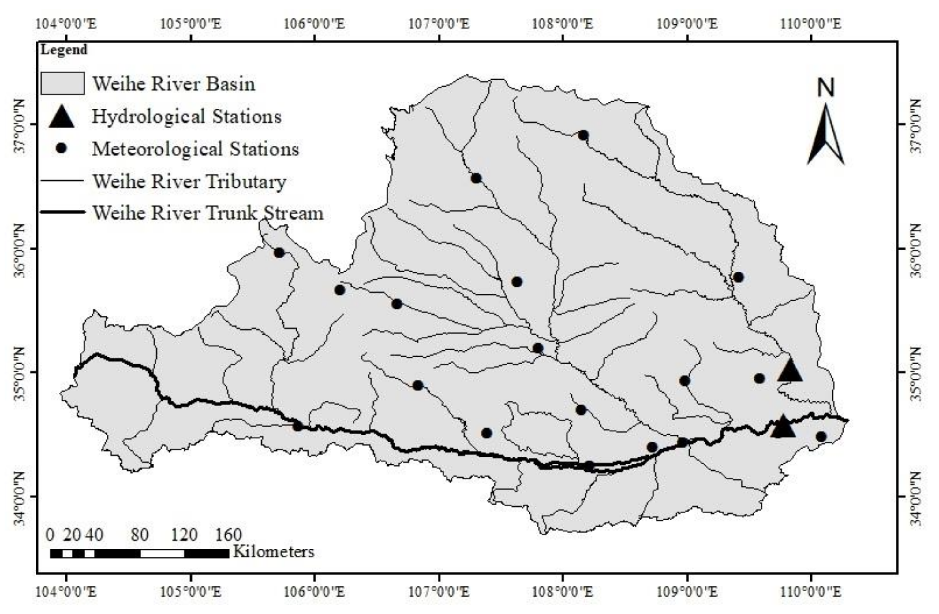
2. Study Area
3. Data and Methodology
3.1. Data Collection and Preprocessing
3.2. Methodology
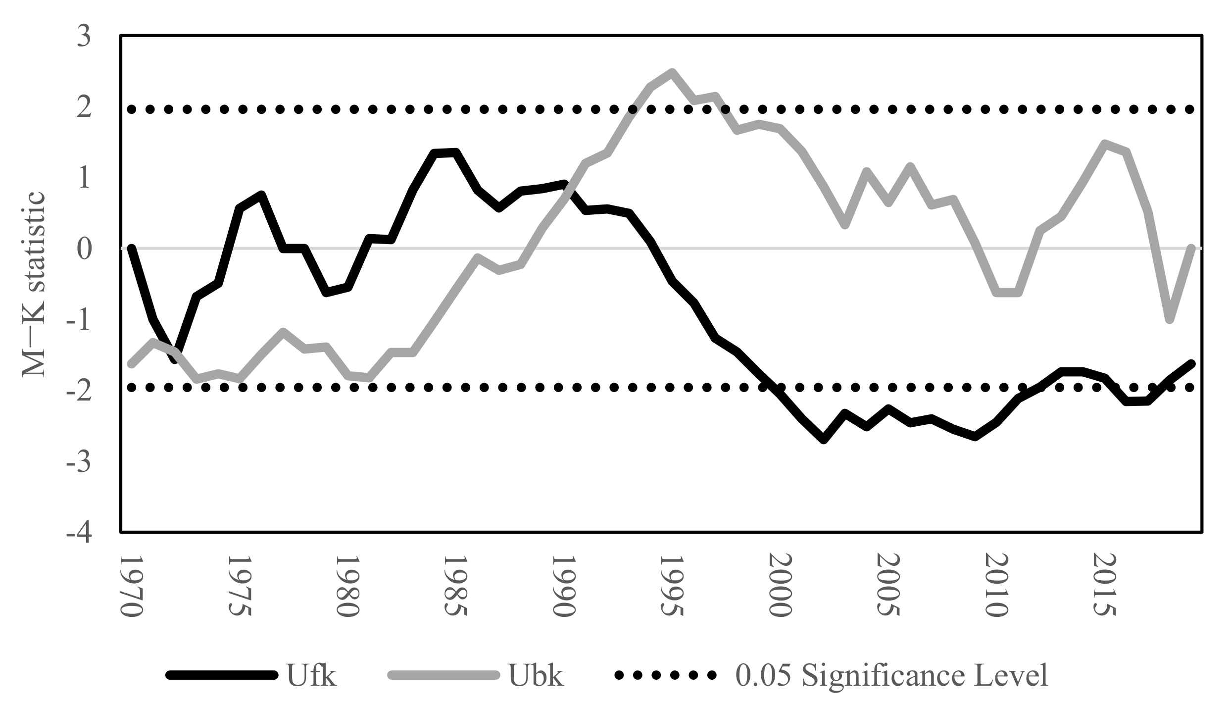
3.2.1. Mann–Kendall Analysis Method
3.2.2. Runoff Change Attribution Identification Based on the Budyko Framework
- 1.
- The Budyko Framework
- 2.
- Climate Elasticity Analysis Method
4. Results
4.1. Analysis of Hydrometeorological Elements
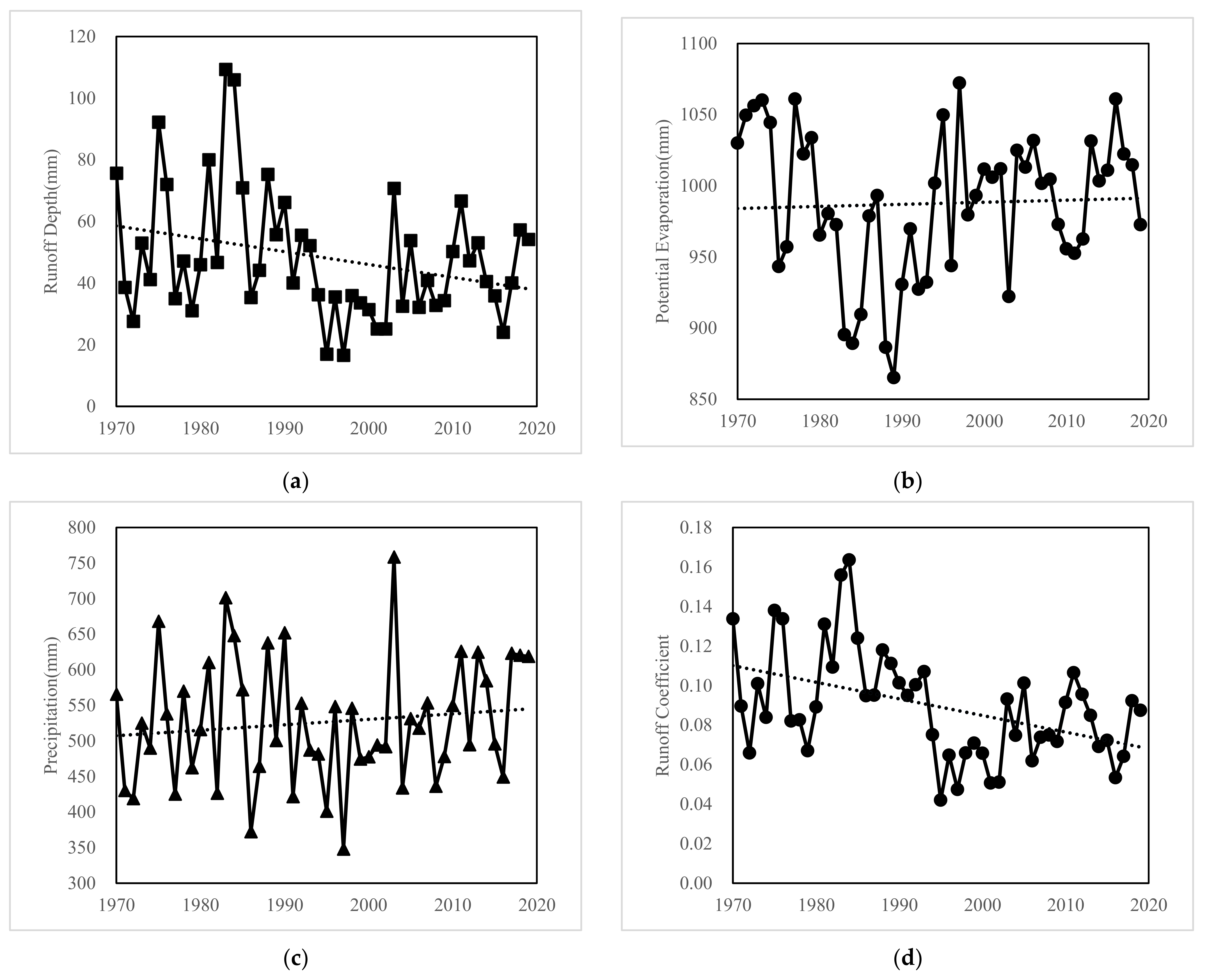
4.1.1. Trend Analysis
4.1.2. Mutation Point Detection
4.2. Analysis of Hydrometeorological Elements
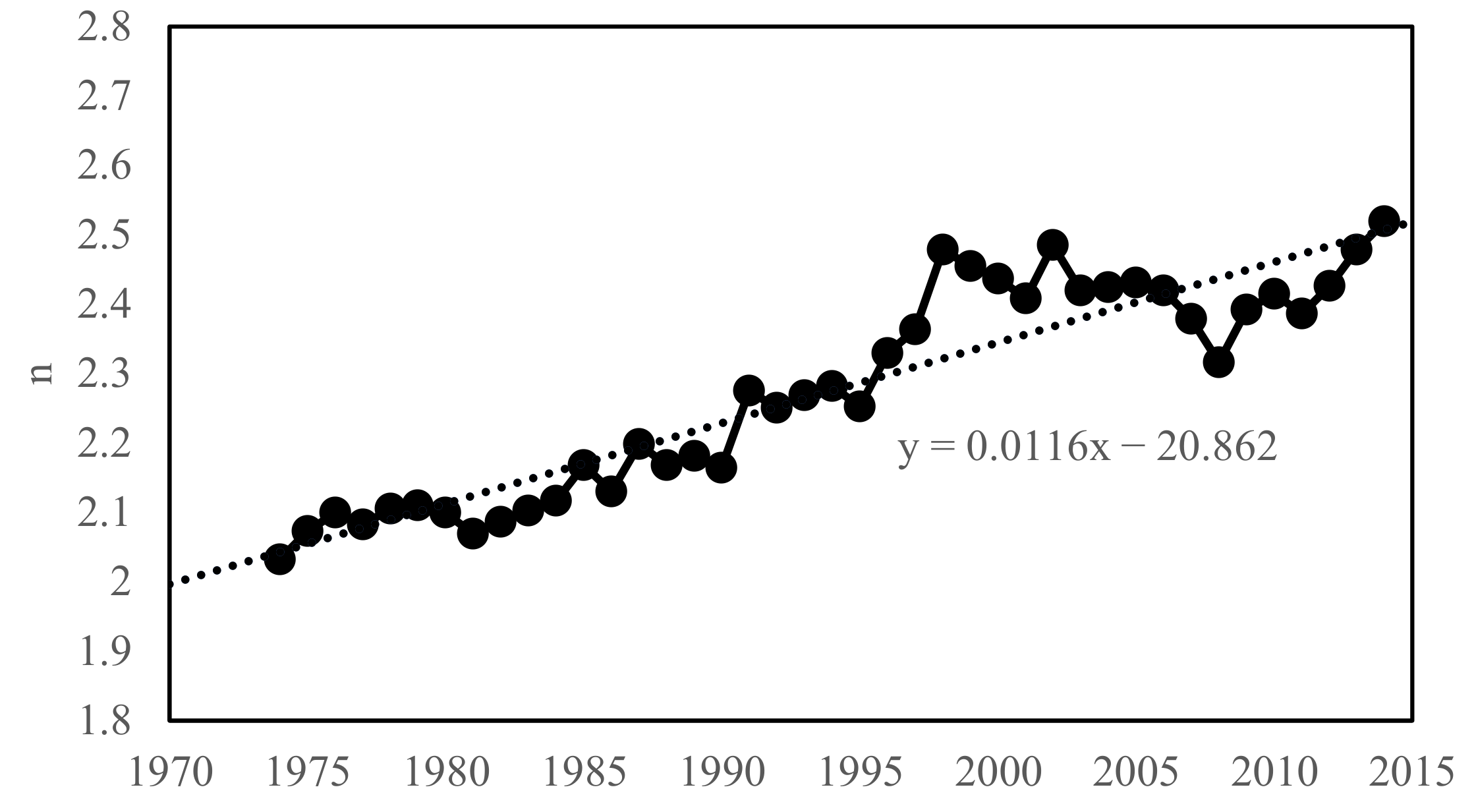
4.3. Runoff Change Attribution Identification
5. Discussion
6. Conclusions
- 1.
- Runoff in the Weihe River basin shows a decreasing trend during 1970–2019 with an abrupt change in 1990 and then decreasing significantly; potential evapotranspiration and precipitation increases slightly during 1970–2019, with the rate of 1.46 mm and 7.68 mm per decade, respectively.
- 2.
- According to the elasticity coefficients of each period, runoff is the most sensitive to precipitation (2.72~3.17), second most sensitive to underlying surface parameter (−2.01~−2.35), and least sensitive to potential evapotranspiration (−1.72~−2.17). Underlying surface parameter and potential evapotranspiration were negatively correlated with runoff, while precipitation was positively correlated.
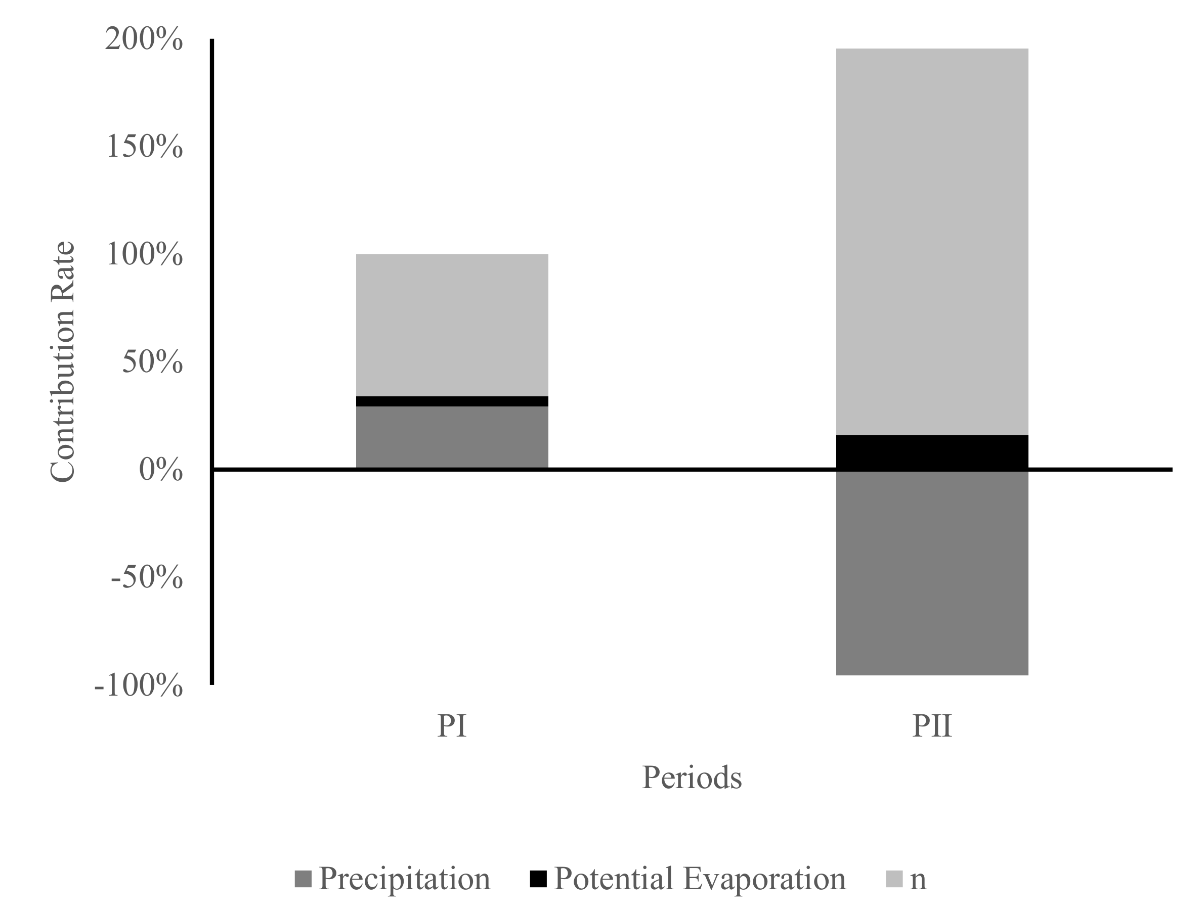
- 3.
- During 1990–2009, the increase in underlying surface parameter led to a decrease in runoff by 13.92 mm, which contributed 66.11% to the runoff variation. The effect of precipitation and potential evapotranspiration was a secondary factor. The combination effects of precipitation, potential evapotranspiration and underlying surface parameter changes resulted in a significant decrease in runoff by 21.06 mm. During 2010–2019, underlying surface parameter increased further, resulting in a 22.19 mm decrease in runoff, accounting for 179.65% of runoff change; precipitation turned to an upward trend, which led to a 11.80 mm (accounting for −95.56% of the total runoff change) increase in runoff.
- 4.
- In the future, climate change, precipitation, evaporation, and runoff in the Weihe River basin are likely to increase. The increase in vegetation coverage and the interference of human activities will add more uncertainties to the change in the Weihe River runoff. In summary, the runoff of the Weihe River will increase in the future, which requires more comprehensive assessment of climate change and human activities.
Author Contributions
Funding
Institutional Review Board Statement
Informed Consent Statement
Conflicts of Interest
References
- Zhang, L.P.; Xia, J.; Hu, Z.F. Situation and problem analysis of water resource security in China. Resour. Environ. Yangtze Basin 2009, 18, 116–120. [Google Scholar]
- Zhang, Q.; Singh, V.P.; Sun, P.; Chen, X.; Zhang, Z.; Li, J. Precipitation and streamflow changes in China: Changing patterns, causes and implications. J. Hydrol. 2011, 410, 204–216. [Google Scholar] [CrossRef]
- Wagener, T.; Sivapalan, M.; Troch, P.A.; McGlynn, B.L.; Harman, C.J.; Gupta, H.V.; Kumar, P.; Rao, P.S.; Basu, N.B.; Wilson, J.S. The future of hydrology: An evolving science for a changing world. Water Resour. Res. 2010, 46, W05301. [Google Scholar] [CrossRef]
- Zhang, Y.; Guan, D.; Jin, C.; Wang, A.; Wu, J.; Yuan, F. Analysis of impacts of climate variability and human activity on streamflow for a river basin in northeast China. J. Hydrol. 2011, 410, 239–247. [Google Scholar] [CrossRef]
- Ma, H.; Yang, D.; Tan, S.K.; Gao, B.; Hu, Q. Impact of climate variability and human activity on streamflow decrease in the Miyun Reservoir catchment. J. Hydrol. 2010, 389, 317–324. [Google Scholar] [CrossRef]
- Budyko, M.I. Climate and Life; Academic Press: Cambridge, MA, USA, 1974. [Google Scholar]
- Choudhury, B. Evaluation of an empirical equation for annual evaporation using field observations and results from a biophysical model. J. Hydrol. 1999, 216, 99–110. [Google Scholar] [CrossRef]
- Yokoo, Y.; Sivapalan, M.; Oki, T. Investigating the roles of climate seasonality and landscape characteristics on mean annual and monthly water balances. J. Hydrol. 2008, 357, 255–269. [Google Scholar] [CrossRef]
- Zhang, S.; Yang, H.; Yang, D. Quantifying the effect of vegetation change on the regional water balance within the Budyko Framework. Geophys. Res. Lett. 2015, 43, 1140–1148. [Google Scholar] [CrossRef]
- Depeng, Z.; Zongxue, X.; Caihong, S. Impact of change and human activity on streamflow in the wei river basin. J. Beijing Norm. Univ. 2013, 49, 115–123. [Google Scholar]
- Sun, Y.; Li, D. Features and response to climate-driven factors of the runoff in the upper reaches of the Weihe River in 1975–2011. J. Glaciol. Geocryol. 2014, 36, 413–423. [Google Scholar]
- Shi, R.; Tian, P.; Zhao, G.; Mu, X.; Zou, Y.; Liu, Y. Comparative study of runoff changes and their attribution in typical watersheds in China’s north-south transitional zone. Yellow River 2020, 42, 29–35. [Google Scholar]
- Zhang, L.; Zhao, G.; Mu, X.; Gao, P.; Sun, W. Attribution of runoff variation in the Wei River basin based on the Budyko hypothesis. Acta Ecol. Sin. 2018, 38, 7607–7617. [Google Scholar]
- Yellow River Conservancy Commission of the Ministry of Water Resources. The Main Tributaries of the Yellow River System. Available online: http://www.yrcc.gov.cn/hhyl/hhgk/hd/sx/201108/t20110814_103450.html,2011-08-14 (accessed on 3 April 2021).
- China Meteorlogical Administration. Grades of Meteorological Drought: GB/T 20481-2017; Standards Press of China: Beijing, China, 1996.
- Wei, F. Xiandai Qihou Tongji Zhenduan Yu Yuce Jishu; Meteorological Press: Beijing, China, 2007.
- Roderick, M.L. A simple framework for relating variations in runoff to variations in climatic conditions and catchment properties. Water Resour. Res. 2011, 47, W00G07. [Google Scholar] [CrossRef]
- Yang, D.; Zhang, S.; Xu, X. Attribution analysis for runoff decline in Yellow River Basin during past fifty years based on Budyko hypothesis. Sci. Sin. 2015, 45, 1024–1034. [Google Scholar]
- Liliang, R.; Hongren, S.; Fei, Y.; Chongxu, Z.H.; Xiaoli, Y.A.; Peili, Z.H. Hydrological drought characteristics in the Weihe catchment in a changing environmen. Adv. Water Sci. 2016, 27, 492–500. [Google Scholar]
- Hou, Q.L.; Bai, H.Y.; Ren, Y.Y.; He, Y.N.; Ma, X.P. Analysis of variation in runoff of the main stream of the Weihe River and related driving forces over the last 50 years. Resour. Sci. 2011, 33, 1505–1512. [Google Scholar]
- Caixia, B.; Xingmin, M.; Guangju, Z.; Hua, B. Effects of climate change and human activity on streamflow in the Wei River Basin. Sci. Soil Water Conserv. 2013, 11, 33–38. [Google Scholar]
- Liu, Y.; Wang, G.; Jin, J.; Bao, Z.; Liu, C. An attribution method for catchment-scale runoff variation evaluation under environmental change based on Budyko hypothesis. Hydro-Sci. Eng. 2014, 6, 1–8. [Google Scholar]
- Ning, Y.; Yang, X.; Sun, W.; Mu, X.; Gao, P.; Zhao, G.; Song, X. The trend of runoff change and its attribution in the middle reaches of the Yellow River. J. Nat. Resour. 2021, 36, 256–269. [Google Scholar] [CrossRef]
- Tang, D. Middle Reaches of Yellow River Protection Forest System Construction and Soil and Water Conservation; Northwest University Press: Xi’an, China, 2000. [Google Scholar]


| Researcher | Main Influencing Factors | Contribution Rate |
|---|---|---|
| Zuo | Human activities | More than 50% |
| Sun | Potential evapotranspiration | More than 60% |
| Shi | Human activities | 48.87% |
| Zhang | Human activities | More than 60% |
| Area | Watershed Area (104 km2) | Runoff (104 m3/a) | Runoff Depth (mm/a) | Rainfall (mm/a) | Period (Year) |
|---|---|---|---|---|---|
| Weihe River Basin | 14.48 | 638,525.14 | 48.34 | 526.11 | 1970~2019 |
| Elements | M–K Method Statistic | 0.05 Significance Level | Significance | Linear Fitting Formula | Maximum Value/mm | Minimum Value/mm | Extreme Value Ratio |
|---|---|---|---|---|---|---|---|
| Runoff depth, Q | −2.05 | ±1.96 | Significant | y = −0.4167x + 879.52 | 109.31 | 16.48 | 6.63 |
| Potential evapotranspiration, ET | −0.04 | Not significant | y = 0.1464x + 695.76 | 1072.17 | 865.16 | 1.24 | |
| Precipitation, P | 0.61 | Not significant | y = 0.7675x − 1004.6 | 758.16 | 347.74 | 2.18 | |
| Runoff coefficient, a | −3.29 | Significant | y = −0.0008x + 1.7665 | 0.16 | 0.04 | 4 |
| Periods\Elements | Precipitation | Runoff Depth | Potential Evaporation | ||||||
|---|---|---|---|---|---|---|---|---|---|
| Average Value/mm | Amount of Change/mm | Rate of Change | Average Value/mm | Amount of Change/mm | Rate of Change | Average Value/mm | Amount of Change/mm | Rate of Change | |
| Base periods | 526.90 | - | - | 59.09 | - | - | 979.73 | - | - |
| PΙ | 504.11 | −22.79 | −4.33% | 38.32 | −20.77 | −35.15% | 990.04 | 10.31 | 1.05% |
| PII | 568.55 | 41.65 | 7.90% | 46.86 | −12.23 | −20.70% | 998.74 | 19.01 | 1.94% |
| Periods\Elasticity Coefficients | Underlying Subsurface Parameter, n | |||
|---|---|---|---|---|
| Base period | 2.06 | 2.72 | −1.72 | −2.01 |
| PΙ | 2.35 | 3.06 | −2.06 | −2.35 |
| PII | 2.52 | 3.17 | −2.17 | −2.18 |
| Periods\Elements | ∂Q/∂P ∆P + ∂Q/∂ET ∆ET + ∂Q/∂n ∆n/mm | Difference/mm | ||||
|---|---|---|---|---|---|---|
| PΙ | −6.18 | −0.95 | 13.92 | −20.77 | −21.06 | 0.29 |
| PII | 11.80 | −1.96 | 22.19 | −12.23 | −12.35 | 0.12 |
Publisher’s Note: MDPI stays neutral with regard to jurisdictional claims in published maps and institutional affiliations. |
© 2021 by the authors. Licensee MDPI, Basel, Switzerland. This article is an open access article distributed under the terms and conditions of the Creative Commons Attribution (CC BY) license (https://creativecommons.org/licenses/by/4.0/).
Share and Cite
Xu, J.; Gao, X.; Yang, Z.; Xu, T. Trend and Attribution Analysis of Runoff Changes in the Weihe River Basin in the Last 50 Years. Water 2022, 14, 47. https://doi.org/10.3390/w14010047
Xu J, Gao X, Yang Z, Xu T. Trend and Attribution Analysis of Runoff Changes in the Weihe River Basin in the Last 50 Years. Water. 2022; 14(1):47. https://doi.org/10.3390/w14010047
Chicago/Turabian StyleXu, Junjie, Xichao Gao, Zhiyong Yang, and Tianyin Xu. 2022. "Trend and Attribution Analysis of Runoff Changes in the Weihe River Basin in the Last 50 Years" Water 14, no. 1: 47. https://doi.org/10.3390/w14010047
APA StyleXu, J., Gao, X., Yang, Z., & Xu, T. (2022). Trend and Attribution Analysis of Runoff Changes in the Weihe River Basin in the Last 50 Years. Water, 14(1), 47. https://doi.org/10.3390/w14010047