
Controls on Streamflow Densities in Semiarid Rocky Mountain Catchments


 , ,
, ,
Abstract
:1. Introduction
2. Materials and Methods
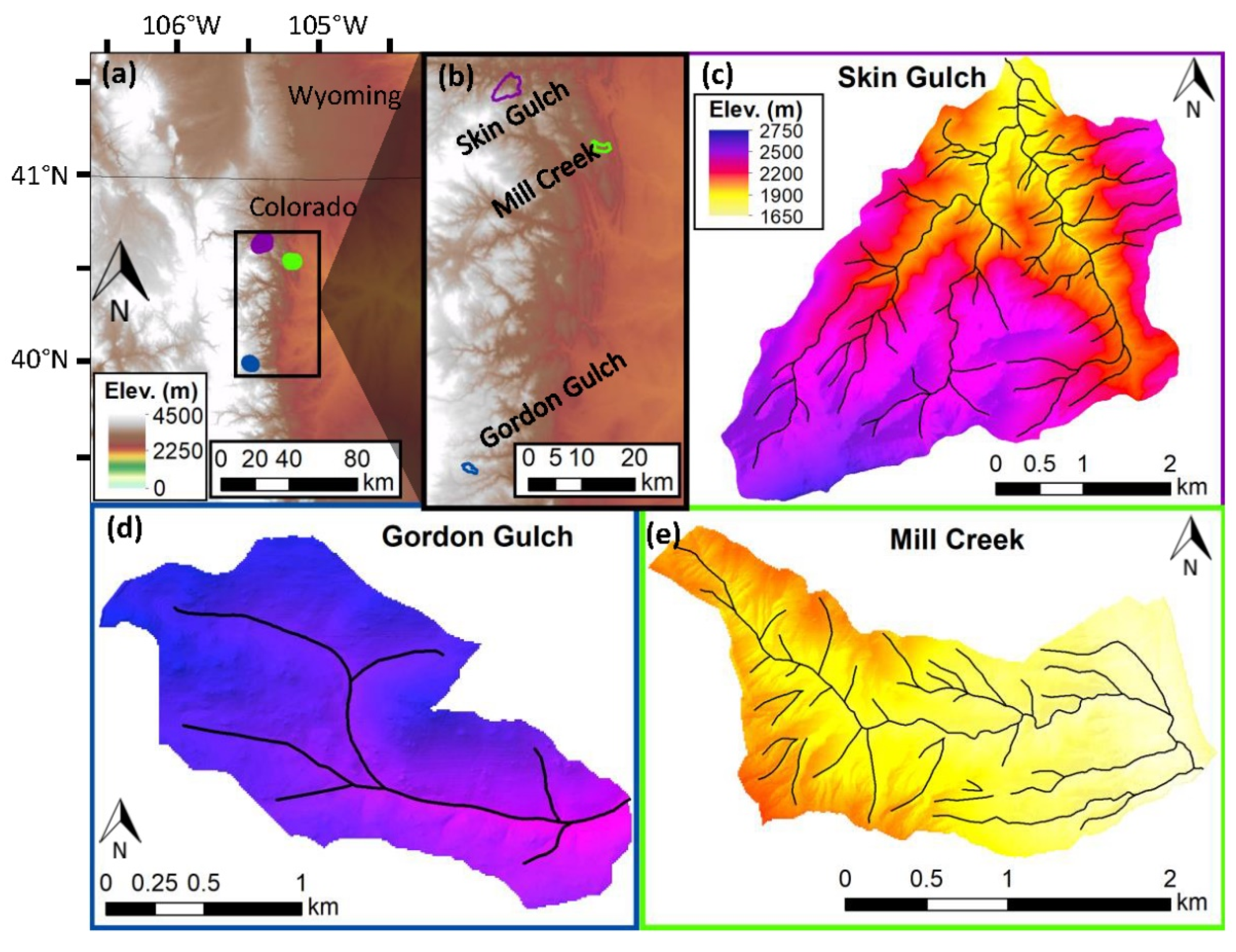
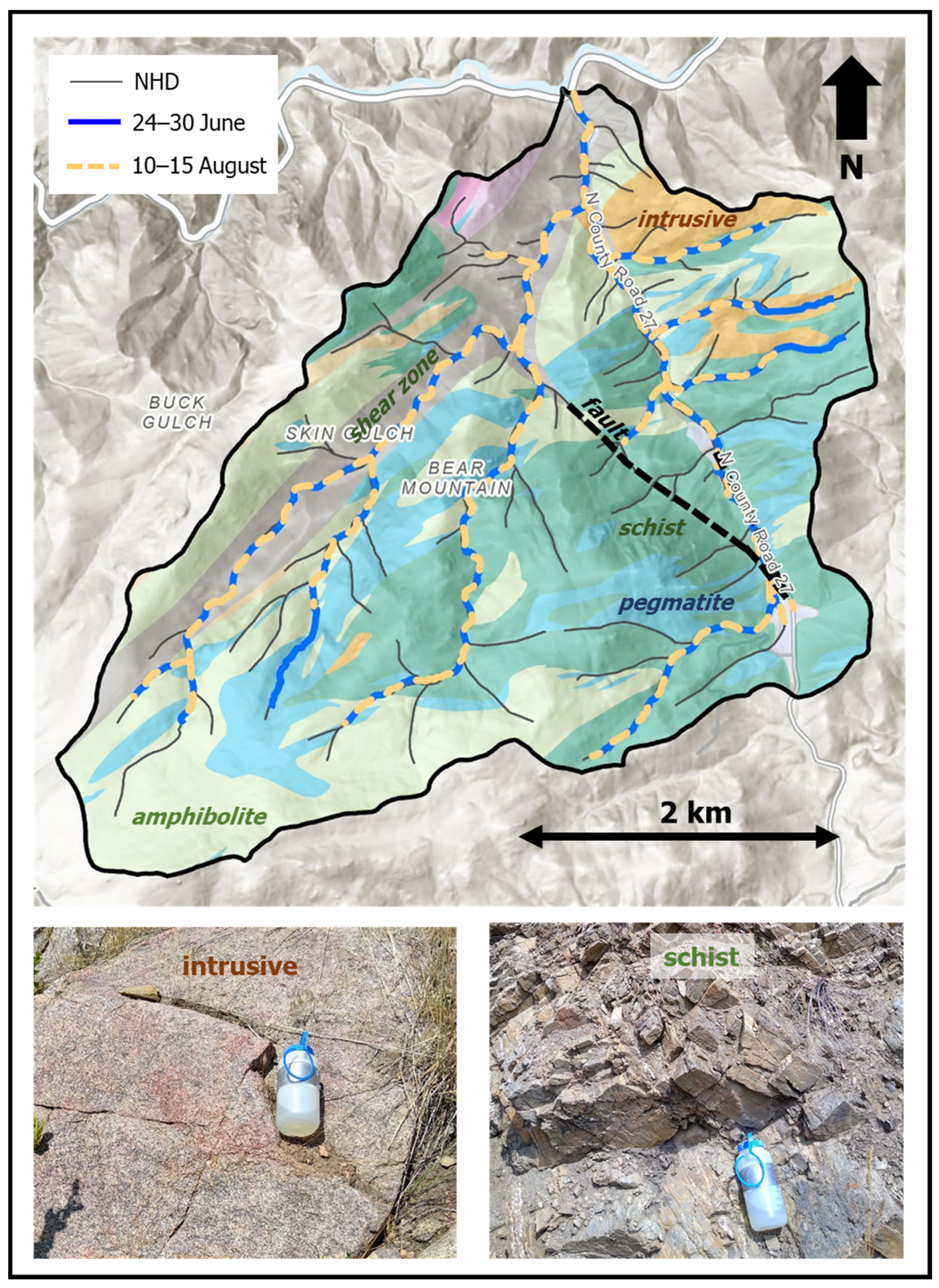
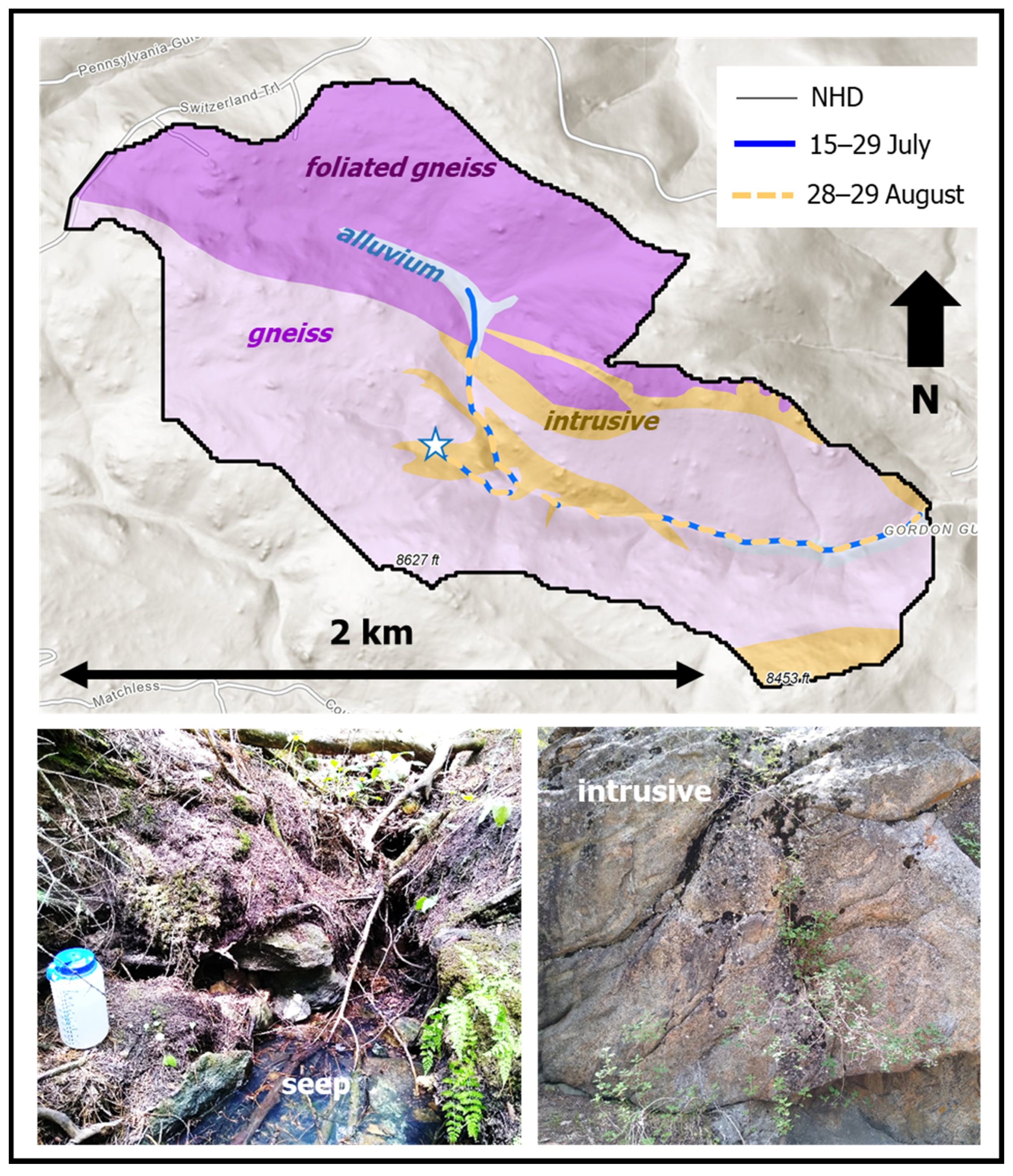
2.1. Study Sites
2.2. Data and Analysis Methods
3. Results
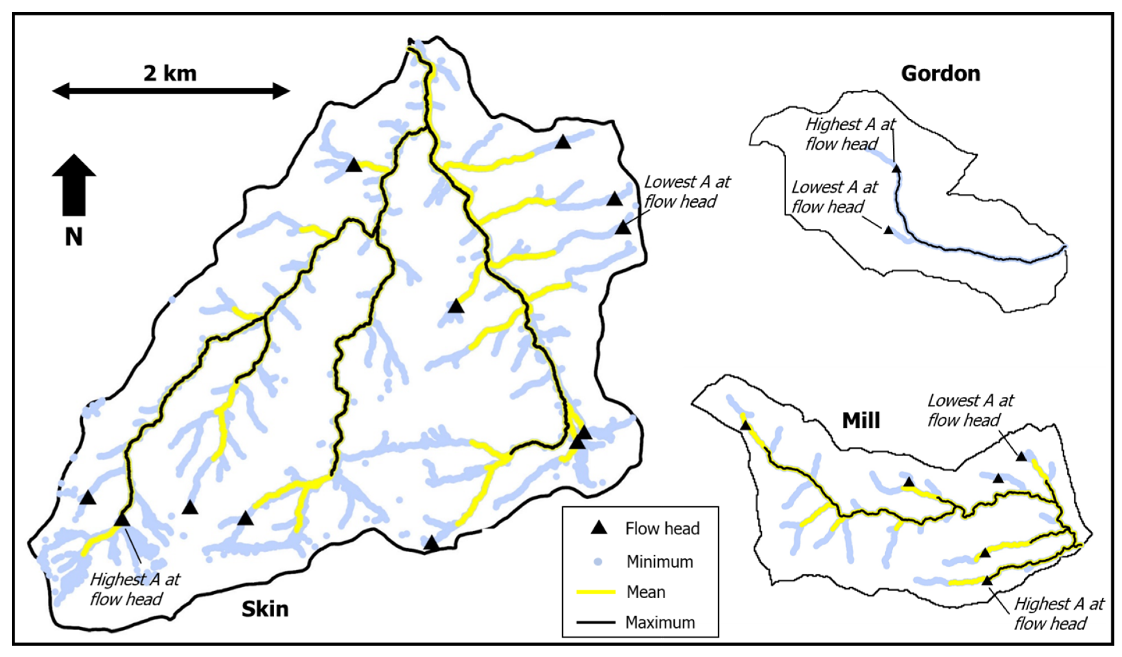
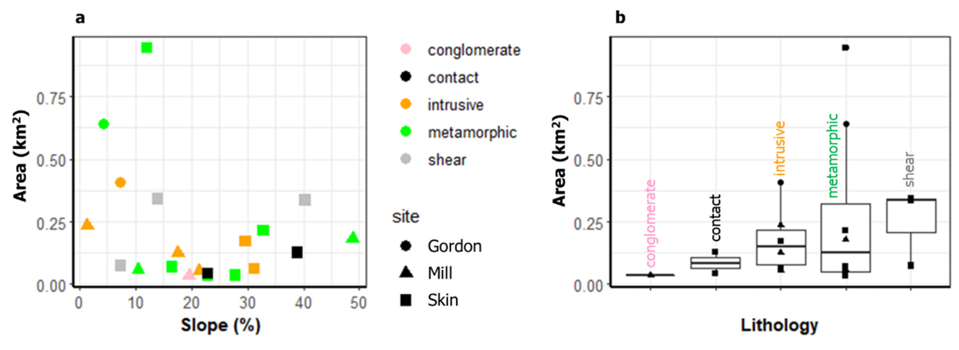
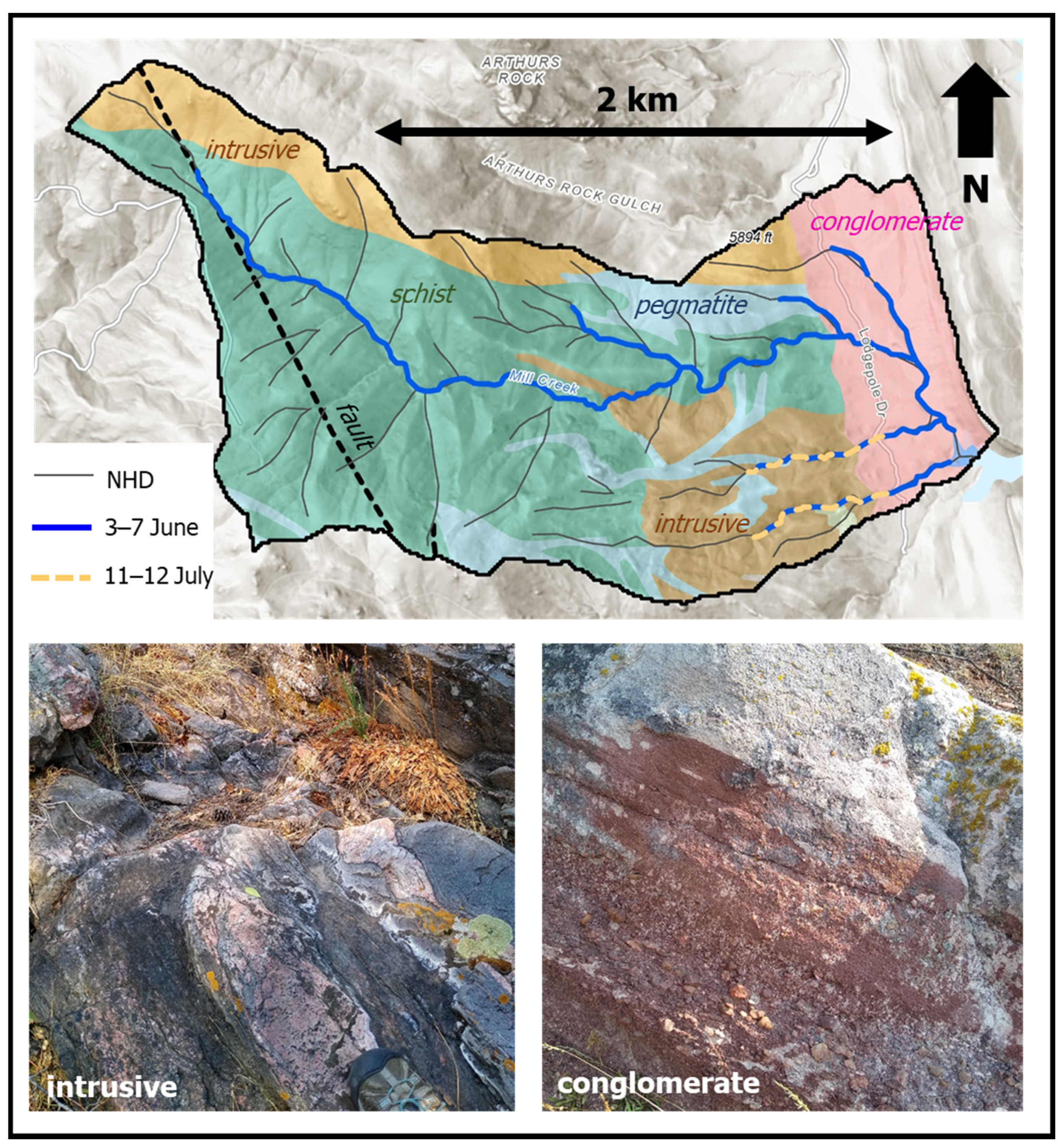
3.1. Field Surveys
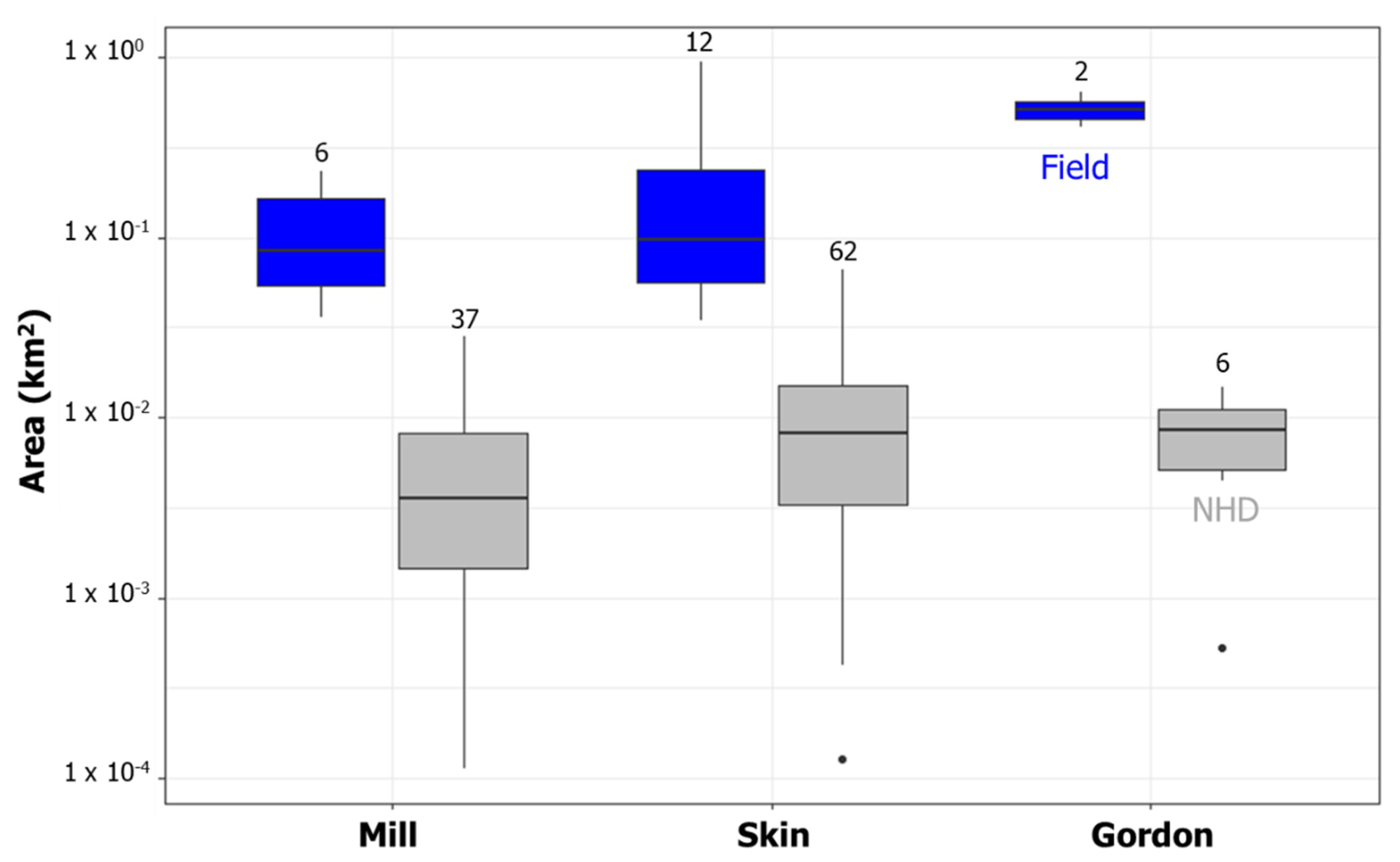
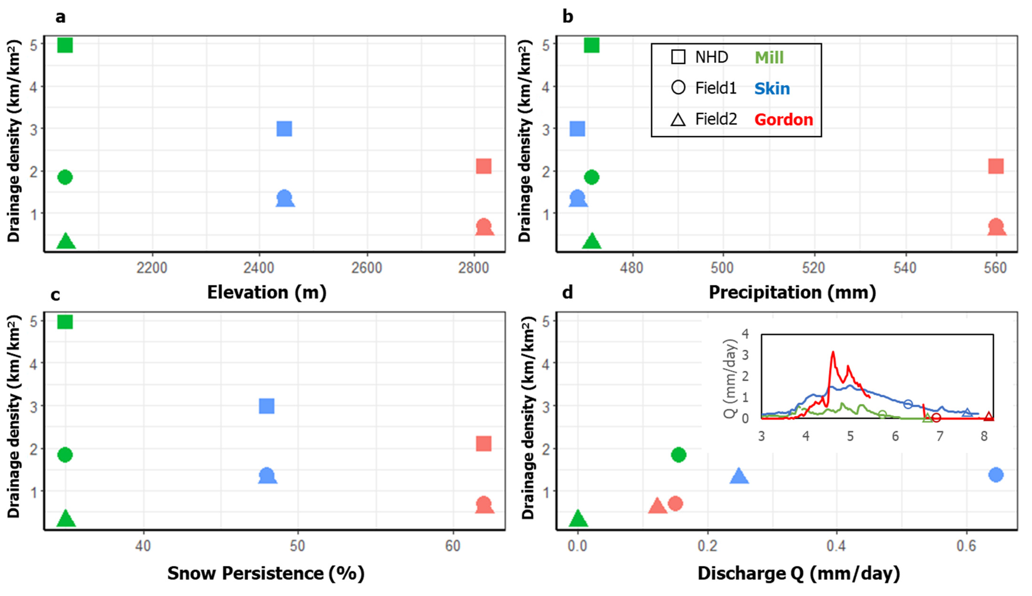
3.2. Catchment Comparison
4. Discussion
4.1. Geologic Influences
4.2. Topographic Thresholds
4.3. Climate and Land Cover Influences
4.4. Implications for Future Research
5. Conclusions
Author Contributions
Funding
Institutional Review Board Statement
Informed Consent Statement
Data Availability Statement
Acknowledgments
Conflicts of Interest
References
- Datry, T.; Larned, S.T.; Tockner, K. Intermittent Rivers: A Challenge for Freshwater Ecology. BioScience 2014, 64, 229–235. [Google Scholar] [CrossRef] [Green Version]
- Nadeau, T.-L.; Rains, M.C. Hydrological Connectivity of Headwaters to Downstream Waters: Introduction to the Featured Collection. JAWRA J. Am. Water Resour. Assoc. 2007, 43, 1–4. [Google Scholar] [CrossRef]
- Acuña, V.; Hunter, M.; Ruhí, A. Managing temporary streams and rivers as unique rather than second-class ecosystems. Biol. Conserv. 2017, 211, 12–19. [Google Scholar] [CrossRef]
- Dewald, T. Making the Digital Water Flow: The Evolution of Geospatial Surface Water Frameworks; USEPA Office of Water: Washington, DC, USA, 2017; 8p.
- Hansen, W.F. Identifying stream types and management implications. For. Ecol. Manag. 2001, 143, 39–46. [Google Scholar] [CrossRef]
- Fritz, K.; Hagenbuch, E.; D’Amico, E.; Reif, M.; Wigington, P.; Leibowitz, S.; Comeleo, R.; Ebersole, J.; Nadeau, T. Comparing the Extent and Permanence of Headwater Streams from Two Field Surveys to Values from Hydrologic Databases and Maps. J. Am. Water Resour. Assoc. 2013, 49, 867–882. [Google Scholar] [CrossRef]
- Villines, J.A.; Agouridis, C.T.; Warner, R.C.; Barton, C.D. Using GIS to Delineate Headwater Stream Origins in the Appalachian Coalfields of Kentucky. JAWRA J. Am. Water Resour. Assoc. 2015, 51, 1667–1687. [Google Scholar] [CrossRef]
- Dietrich, W.E.; Dunne, T. The channel head. In Channel Network Hydrology; Beven, K., Kirkby, M.J., Eds.; Wiley: London, UK, 1993; pp. 175–219. [Google Scholar]
- Bull, L.; Kirkby, M. Gully processes and modelling. Prog. Phys. Geogr. Earth Environ. 1997, 21, 354–374. [Google Scholar] [CrossRef]
- Day, D.G. Drainage density changes during rainfall. Earth Surf. Process. Landf. 1978, 3, 319–326. [Google Scholar] [CrossRef]
- Jaeger, K.L.; Montgomery, D.R.; Bolton, S.M. Channel and Perennial Flow Initiation in Headwater Streams: Management Implications of Variability in Source-Area Size. Environ. Manag. 2007, 40, 775–786. [Google Scholar] [CrossRef] [Green Version]
- Godsey, S.E.; Kirchner, J.W. Dynamic, discontinuous stream networks: Hydrologically driven variations in active drainage density, flowing channels and stream order. Hydrol. Process. 2014, 28, 5791–5803. [Google Scholar] [CrossRef]
- Goulsbra, C.; Evans, M.; Lindsay, J. Temporary streams in a peatland catchment: Pattern, timing, and controls on stream network expansion and contraction. Earth Surf. Process. Landf. 2014, 39, 790–803. [Google Scholar] [CrossRef]
- Shaw, S.B.; Bonville, D.B.; Chandler, D.G. Combining observations of channel network contraction and spatial discharge variation to inform spatial controls on baseflow in Birch Creek, Catskill Mountains, USA. J. Hydrol. Reg. Stud. 2017, 12, 1–12. [Google Scholar] [CrossRef]
- Lovill, S.M.; Hahm, W.J.; Dietrich, W.E. Drainage from the Critical Zone: Lithologic Controls on the Persistence and Spatial Extent of Wetted Channels during the Summer Dry Season. Water Resour. Res. 2018, 54, 5702–5726. [Google Scholar] [CrossRef]
- Barefoot, E.; Pavelsky, T.M.; Allen, G.H.; Zimmer, M.A.; McGlynn, B.L. Temporally variable stream width and surface area dis-tributions in a headwater catchment. Water Resour. Res. 2019, 55, 7166–7181. [Google Scholar] [CrossRef]
- Van Meerveld, H.J.I.; Kirchner, J.W.; Vis, M.J.P.; Assendelft, R.S.; Seibert, J. Expansion and contraction of the flowing stream network alter hillslope flowpath lengths and the shape of the travel time distribution. Hydrol. Earth Syst. Sci. 2019, 23, 4825–4834. [Google Scholar] [CrossRef] [Green Version]
- Durighetto, N.; Vingiani, F.; Bertassello, L.E.; Camporese, M.; Botter, G. Intraseasonal Drainage Network Dynamics in a Headwater Catchment of the Italian Alps. Water Resour. Res. 2020, 56, e2019WR025563. [Google Scholar] [CrossRef] [Green Version]
- Perez, A.; Innocente dos Santos, C.; Sá, J.H.; Arienti, P.F.; Chaffe, P.L. Connectivity of Ephemeral and Intermittent Streams in a Subtropical Atlantic Forest Headwater Catchment. Water 2020, 12, 1526. [Google Scholar] [CrossRef]
- Abrahams, A.D.; Ponczynski, J.J. Drainage density in relation to precipitation intensity in the U.S.A. J. Hydrol. 1984, 75, 383–388. [Google Scholar] [CrossRef]
- Collins, D.B.G.; Bras, R.L. Climatic and ecological controls of equilibrium drainage density, relief, and channel concavity in dry lands. Water Resour. Res. 2010, 46. [Google Scholar] [CrossRef] [Green Version]
- Abrahams, A.D. Channel Networks: A Geomorphological Perspective. Water Resour. Res. 1984, 20, 161–188. [Google Scholar] [CrossRef]
- Sangireddy, H.; Carothers, R.A.; Stark, C.P.; Passalacqua, P. Controls of climate, topography, vegetation, and lithology on drainage density extracted from high resolution topography data. J. Hydrol. 2016, 537, 271–282. [Google Scholar] [CrossRef] [Green Version]
- Day, D.G. Lithologic controls of drainage density: A study of six small rural catchments in New England, N.S.W. Catena 1980, 7, 339–351. [Google Scholar] [CrossRef]
- Prancevic, J.P.; Kirchner, J.W. Topographic Controls on the Extension and Retraction of Flowing Streams. Geophys. Res. Lett. 2019, 46, 2084–2092. [Google Scholar] [CrossRef] [Green Version]
- Jensen, C.K.; McGuire, K.J.; Prince, P.S. Headwater stream length dynamics across four physiographic provinces of the Appalachian Highlands. Hydrol. Process. 2017, 31, 3350–3363. [Google Scholar] [CrossRef] [Green Version]
- Whiting, J.A.; Godsey, S.E. Discontinuous headwater stream networks with stable flowheads, Salmon River basin, Idaho. Hydrol. Process. 2016, 30, 2305–2316. [Google Scholar] [CrossRef]
- Alfaro, C.; Wallace, M. Origin and classification of springs and historical review with current applications. Environ. Earth Sci. 1994, 24, 112–124. [Google Scholar] [CrossRef]
- Montgomery, D.R.; Dietrich, W.E. Where do channels begin? Nat. Cell Biol. 1988, 336, 232–234. [Google Scholar] [CrossRef]
- Tarboton, D.G.; Bras, R.L.; Rodriguez-Iturbe, I. On the extraction of channel networks from digital elevation data. Hydrol. Process. 1991, 5, 81–100. [Google Scholar] [CrossRef]
- Tarboton, D.G.; Bras, R.L.; Rodriguez-Iturbe, I. A physical basis for drainage density. Geomorphology 1992, 5, 59–76. [Google Scholar] [CrossRef]
- Benstead, J.P.; Leigh, D.S. An expanded role for river networks. Nat. Geosci. 2012, 5, 678–679. [Google Scholar] [CrossRef]
- Beven, K.; Kirkby, M. A physically based variable contributing area model of basin hydrology. Hydrol. Sci. Bull. 1979, 24, 43–69. [Google Scholar] [CrossRef] [Green Version]
- Helmlinger, K.R.; Kumar, P.; Foufoula-Georgiou, E. On the use of digital elevation model data for Hortonian and fractal analyses of channel networks. Water Resour. Res. 1993, 29, 2599–2613. [Google Scholar] [CrossRef]
- Heine, R.A.; Lant, C.L.; Sengupta, R.R. Development and Comparison of Approaches for Automated Mapping of Stream Channel Networks. Ann. Assoc. Am. Geogr. 2004, 94, 477–490. [Google Scholar] [CrossRef]
- Clubb, F.J.; Mudd, S.M.; Milodowski, D.T.; Hurst, M.D.; Slater, L.J. Objective extraction of channel heads from high-resolution topographic data. Water Resour. Res. 2014, 50, 4283–4304. [Google Scholar] [CrossRef] [Green Version]
- Zhang, W.; Montgomery, D.R. Digital elevation model grid size, landscape representation, and hydrologic simulations. Water Resour. Res. 1994, 30, 1019–1028. [Google Scholar] [CrossRef]
- Wolock, D.M.; McCabe, G.J. Differences in topographic characteristics computed from 100- and 1000-m resolution digital elevation model data. Hydrol. Process. 2000, 14, 987–1002. [Google Scholar] [CrossRef]
- McMaster, K.J. Effects of digital elevation model resolution on derived stream network positions. Water Resour. Res. 2002, 38, 13-1–13-8. [Google Scholar] [CrossRef]
- Usery, E.L.; Finn, M.P.; Scheidt, D.J.; Ruhl, S.; Beard, T.; Bearden, M. Geospatial data resampling and resolution effects on watershed modeling: A case study using the agricultural non-point source pollution model. J. Geogr. Syst. 2004, 6, 289–306. [Google Scholar] [CrossRef]
- Kienzle, S. The Effect of DEM Raster Resolution on First Order, Second Order and Compound Terrain Derivatives. Trans. GIS 2003, 8, 83–111. [Google Scholar] [CrossRef]
- Sørensen, R.; Seibert, J. Effects of DEM resolution on the calculation of topographical indices: TWI and its components. J. Hydrol. 2007, 347, 79–89. [Google Scholar] [CrossRef]
- Colson, T.; Gregory, J.; Dorney, J.; Russell, P. Topographic and soil maps do not accurately depict headwater stream networks. Natl. Wetl. Newsl. 2008, 30, 25–28. [Google Scholar]
- Vaze, J.; Teng, J.; Spencer, G. Impact of DEM accuracy and resolution on topographic indices. Environ. Model. Softw. 2010, 25, 1086–1098. [Google Scholar] [CrossRef]
- Hastings, B.E.; Kampf, S.K. Evaluation of digital channel network derivation methods in a glaciated subalpine catchment. Earth Surf. Process. Landf. 2014, 39, 1790–1802. [Google Scholar] [CrossRef]
- Orlandini, S.; Tarolli, P.; Moretti, G.; Fontana, G.D. On the prediction of channel heads in a complex alpine terrain using gridded elevation data. Water Resour. Res. 2011, 47. [Google Scholar] [CrossRef] [Green Version]
- Jencso, K.G.; McGlynn, B.L. Hierarchical controls on runoff generation: Topographically driven hydrologic connectivity, geology, and vegetation. Water Resour. Res. 2011, 47. [Google Scholar] [CrossRef] [Green Version]
- Emanuel, R.E.; Hazen, A.G.; McGlynn, B.L.; Jencso, K.G. Vegetation and topographic influences on the connectivity of shallow groundwater between hillslopes and streams. Ecohydrology 2013, 7, 887–895. [Google Scholar] [CrossRef]
- Wagener, T.; Sivapalan, M.; Troch, P.; Woods, R. Catchment Classification and Hydrologic Similarity. Geogr. Compass 2007, 1, 901–931. [Google Scholar] [CrossRef]
- Ferreras, A.M.G.; Barquín, J. Mapping the temporary and perennial character of whole river networks. Water Resour. Res. 2017, 53, 6709–6724. [Google Scholar] [CrossRef] [Green Version]
- Jensen, C.K.; McGuire, K.J.; Shao, Y.; Dolloff, C.A. Modeling wet headwater stream networks across multiple flow conditions in the Appalachian Highlands. Earth Surf. Process. Landf. 2018, 43, 2762–2778. [Google Scholar] [CrossRef] [Green Version]
- Braddock, W.A.; Calvert, R.; O’Connor, J.T.; Swann, G. Geologic Map of the Horsetooth Reservoir Quadrangle, Larimer County, Colorado; U.S. Geological Survey: Washington, DC, USA, 1989.
- Daly, C. Descriptions of PRISM Spatial Climate Datasets for the Conterminous United States; PRISM Climate Group: Corvallis, OR, USA, 2013; 14p. [Google Scholar]
- Abatzoglou, J.T. Development of gridded surface meteorological data for ecological applications and modelling. Int. J. Clim. 2013, 33, 121–131. [Google Scholar] [CrossRef]
- Nesse, W.D.; Braddock, W.A. Geologic Map of the Pingree Park Quadrangle, Larimer County, Colorado; U.S. Geological Survey: Washington, DC, USA, 1989.
- Kampf, S.K.; Brogan, D.J.; Schmeer, S.; Macdonald, L.H.; Nelson, P.A. How do geomorphic effects of rainfall vary with storm type and spatial scale in a post-fire landscape? Geomorphology 2016, 273, 39–51. [Google Scholar] [CrossRef] [Green Version]
- Schmeer, S.R.; Kampf, S.K.; Macdonald, L.H.; Hewitt, J.; Wilson, C. Empirical models of annual post-fire erosion on mulched and unmulched hillslopes. Catena 2018, 163, 276–287. [Google Scholar] [CrossRef]
- Wohl, E. Migration of channel heads following wildfire in the Colorado Front Range, USA. Earth Surf. Process. Landf. 2013, 38, 1049–1053. [Google Scholar] [CrossRef]
- Wilson, C.; Kampf, S.K.; Ryan, S.; Covino, T.; Macdonald, L.H.; Gleason, H. Connectivity of post-fire runoff and sediment from nested hillslopes and watersheds. Hydrol. Process. 2021, 35. [Google Scholar] [CrossRef]
- Chapin, C.E.; Kelley, S.A. The Rocky Mountain erosion surface in the Front Range of Colorado. In Geologic history of the Colorado Front Range; Bolyard, D.A., Sonnenberg, S.A., Eds.; Rocky Mountain Association of Geologists: Denver, CO, USA, 1997; pp. 101–113. [Google Scholar]
- Gable, D.J. Geologic Map of the Gold Hill Quadrangle, Boulder County, Colorado (No. 1525); U.S. Geological Survey: Washington, DC, USA, 1980.
- Anderson, S.P.; Kelly, P.J.; Hoffman, N.; Barnhart, K.; Befus, K.; Ouimet, W. Is This Steady State? Weathering and Critical Zone Architecture in Gordon Gulch, Colorado Front Range. In Geophysical Monograph Series; Wiley: Hoboken, NJ, USA, 2021; pp. 231–252. [Google Scholar]
- Marr, J.W. Ecosystems of the East Slope of the Front Range in Colorado; Series in Biology; University of Colorado Press: Boulder, CO, USA, 1961; Available online: http://scholar.colorado.edu/sbio/21 (accessed on 30 November 2020).
- Peet, R.K. Forest vegetation of the Colorado Front Range: Composition and dynamics. Vegetation 1981, 45, 3–75. [Google Scholar] [CrossRef]
- Hinckley, E.-L.S.; Ebel, B.A.; Barnes, R.T.; Anderson, R.S.; Williams, M.W.; Anderson, S.P. Aspect control of water movement on hillslopes near the rain-snow transition of the Colorado Front Range. Hydrol. Process. 2014, 28, 74–85. [Google Scholar] [CrossRef]
- Martin, C.; Kampf, S.; Hammond, J. Colorado Front Range Flow Presence Maps. HydroShare. 2020. Available online: http://www.hydroshare.org/resource/4f813a9eeedb494ba8e37a1b8ff58d32 (accessed on 30 November 2020).
- Kampf, S.; Hammond, J.; Richard, G.; Sholtes, J.; Puntenney-Desmond, K.; Willi, K.; Eurich, A.; Harrison, H.; Anenberg, A. Colorado Small Catchment Hydrology Datasets. HydroShare. 2020. Available online: http://www.hydroshare.org/resource/8d8b3c4e3d9c4f538cea53d81791c41e (accessed on 30 November 2020).
- Anderson, S.; Ragar, D. BCCZO—Streamflow/Discharge—(GGL_SW_0_Dis)—Gordon Gulch: Lower—(2011–2019). HydroShare. 2020. Available online: http://www.hydroshare.org/resource/c2384bd1743a4276a88a5110b1964ce0 (accessed on 30 November 2020).
- U.S. Geological Survey. 1 Meter Digital Elevation Models (DEMs)—USGS National Map 3DEP Downloadable Data Collection; U.S. Geological Survey: Washington, DC, USA, 2017. Available online: https://www.sciencebase.gov/catalog/item/543e6b86e4b0fd76af69cf4c (accessed on 30 November 2020).
- National Ecological Observatory Network. Airborne Observation Platform; National Ecological Observatory Network: Boulder, CO, USA, 2013. [Google Scholar]
- Tarboton, D.G. A new method for the determination of flow directions and upslope areas in grid digital elevation models. Water Resour. Res. 1997, 33, 309–319. [Google Scholar] [CrossRef] [Green Version]
- Hammond, J.C.; Saavedra, F.A.; Kampf, S.K. MODIS MOD10A2 Derived Snow Persistence and No Data Index for the Western U.S. HydroShare. 2017. Available online: http://dx.doi.org/10.4211/hs.1c62269aa802467688d25540caf2467e (accessed on 30 November 2020).
- Güntner, A.; Seibert, J.; Uhlenbrook, S. Modeling spatial patterns of saturated areas: An evaluation of different terrain indices. Water Resour. Res. 2004, 40. [Google Scholar] [CrossRef] [Green Version]
- Payn, R.A.; Gooseff, M.N.; McGlynn, B.L.; E Bencala, K.; Wondzell, S.M. Exploring changes in the spatial distribution of stream baseflow generation during a seasonal recession. Water Resour. Res. 2012, 48, 04519. [Google Scholar] [CrossRef] [Green Version]
- Jencso, K.G.; McGlynn, B.L.; Gooseff, M.N.; Wondzell, S.M.; Bencala, K.E.; Marshall, L.A. Hydrologic connectivity between landscapes and streams: Transferring reach-and plot-scale understanding to the catchment scale. Water Resour. Res 2009, 45, W04428. [Google Scholar] [CrossRef] [Green Version]
- Kampf, S.K.; Burges, S.J.; Hammond, J.C.; Bhaskar, A.; Covino, T.P.; Eurich, A.; Harrison, H.; Lefsky, M.; Martin, C.; McGrath, D.; et al. The case for an open water balance: Re-envisioning network design and data analysis for a complex, un-certain world. Water Resour. Res. 2020, 56, e2019WR026699. [Google Scholar] [CrossRef]
- Dietrich, W.E.; Wilson, C.J.; Montgomery, D.R.; Mckean, J.; Bauer, R. Erosion thresholds and land surface morphology. Geology 1992, 20, 675–679. [Google Scholar] [CrossRef]
- Dietrich, W.E.; Wilson, C.J.; Montgomery, D.R.; Mckean, J. Analysis of Erosion Thresholds, Channel Networks, and Landscape Morphology Using a Digital Terrain Model. J. Geol. 1993, 101, 259–278. [Google Scholar] [CrossRef] [Green Version]
- Anenberg, A. Effects of Snow Persistence on Soil Water Nitrogen across an Elevation Gradient. Master’s Thesis, Colorado State University, Fort Collins, CO, USA, 2019. [Google Scholar]
- Henkle, J.E.; Wohl, E.; Beckman, N. Locations of channel heads in the semiarid Colorado Front Range, USA. Geomorphology 2011, 129, 309–319. [Google Scholar] [CrossRef]
- Richer, E.E.; Kampf, S.K.; Fassnacht, S.R.; Moore, C.C. Spatiotemporal index for analyzing controls on snow climatology: Application in the Colorado Front Range. Phys. Geogr. 2013, 34, 85–107. [Google Scholar] [CrossRef]
- Hammond, J.C.; Harpold, A.A.; Weiss, S.; Kampf, S.K. Partitioning snowmelt and rainfall in the critical zone: Effects of climate type and soil properties. Hydrol. Earth Syst. Sci. 2019, 23, 3553–3570. [Google Scholar] [CrossRef] [Green Version]
- Kampf, S.; Strobl, B.; Hammond, J.; Anenberg, A.; Etter, S.; Martin, C.; Puntenney-Desmond, K.; Seibert, J.; Van Meerveld, I. Testing the Waters: Mobile Apps for Crowdsourced Streamflow Data. Eos 2018, 99, 30–34. [Google Scholar] [CrossRef]
- Wohl, E.; Scott, D.N. Transience of channel head locations following disturbance. Earth Surf. Process. Landf. 2017, 42, 1132–1139. [Google Scholar] [CrossRef]
- Brogan, D.J.; Macdonald, L.H.; Nelson, P.A.; Morgan, J.A. Geomorphic complexity and sensitivity in channels to fire and floods in mountain catchments. Geomorphology 2019, 337, 53–68. [Google Scholar] [CrossRef] [Green Version]


| Characteristic | Mill Creek | Skin Gulch | Gordon Gulch |
|---|---|---|---|
| Drainage area (km2) | 3.8 | 15.5 | 2.6 |
| Elevation range (m) | 1651–2166 | 1841–2682 | 2432–2733 |
| Mean slope (°) | 21.5 | 22.3 | 13.9 |
| Mean annual precipitation (mm) 1 | 464 | 516 | 511 |
| 2016 precipitation (mm) 1 | 471 | 468 | 560 |
| Mean annual potential evapotranspiration (PET) (mm) 2 | 1245 | 1135 | 1166 |
| Aridity index 1,2 | 0.37 | 0.45 | 0.44 |
| Trip 1 | Trip 2 | |||||
|---|---|---|---|---|---|---|
| Site | Dates | Discharge | ADD | Dates | Discharge | ADD |
| Mill Creek | 3–7 June | 0.1–0.2 | 1.83 | 11–12 July | 0 | 0.30 |
| Skin Gulch | 24–30 June | 0.6–0.7 | 1.37 | 10–15 August | 0.2–0.3 | 1.29 |
| Gordon Gulch | 15–19 July | 0.1–0.3 | 0.69 | 28–29 August | 0.1–0.3 | 0.61 |
Publisher’s Note: MDPI stays neutral with regard to jurisdictional claims in published maps and institutional affiliations. |
© 2021 by the authors. Licensee MDPI, Basel, Switzerland. This article is an open access article distributed under the terms and conditions of the Creative Commons Attribution (CC BY) license (http://creativecommons.org/licenses/by/4.0/).
Share and Cite
Martin, C.; Kampf, S.K.; Hammond, J.C.; Wilson, C.; Anderson, S.P. Controls on Streamflow Densities in Semiarid Rocky Mountain Catchments. Water 2021, 13, 521. https://doi.org/10.3390/w13040521
Martin C, Kampf SK, Hammond JC, Wilson C, Anderson SP. Controls on Streamflow Densities in Semiarid Rocky Mountain Catchments. Water. 2021; 13(4):521. https://doi.org/10.3390/w13040521
Chicago/Turabian StyleMartin, Caroline, Stephanie K. Kampf, John C. Hammond, Codie Wilson, and Suzanne P. Anderson. 2021. "Controls on Streamflow Densities in Semiarid Rocky Mountain Catchments" Water 13, no. 4: 521. https://doi.org/10.3390/w13040521