Abstract
Groundwater stored in aquifers experiences a wide variety of natural, induced and/or anthropogenic disturbances. Among them, groundwater extraction is the main disturbance that affects most of the aquifers in the world. Aquifer’s resilience, understood as the potential of the aquifer to sustain disturbances on the long term and to guarantee essential qualities and functions, provides a key tool when assessing sustainable groundwater management alternatives. The aim of this work is to illustrate an aquifer resilience framework that can support groundwater sustainable management. A theoretical framework is based on the identification of the key variables that parameterize the quantitative and qualitative responses of the groundwater flow system to pumping. An example from the literature based in Denmark is provided as an illustration of the proposed framework. The results show that long-term high quality data are essential to make a step further in aquifers dynamic responses. The quantitative understanding of the aquifer’s behavior before, during and after groundwater extraction provides a valuable source of information in order to identify thresholds of change (tipping points, transitions or regime shifts) which could permit pro-active groundwater management decisions. Moreover, a deeper understanding on the aquifer’s dynamics provides useful information in order to avert threats that may put the sustainability of the system at risk.
1. Introduction
Groundwater is a valuable and limited resource. Some countries are entirely dependent on groundwater for water supply, while many ecosystems are also groundwater-dependent [1]. In many parts of the world, mainly in arid and semiarid regions, aquifers are subject to stress. Stress can be defined as a situation in which demand is greater than supply and typically leads to aquifer overdrafts [2,3,4] and/or groundwater mining [5]. If we are able to understand the aquifer response to pumping before any harm in the system is produced, undesirable situations could be avoided. Long-term series of specific data may provide the keys to understanding possible changes in aquifer dynamics.
Groundwater sustainability assessments are usually based on snapshots of the water cycle or on an overview of the system evolution over a few decades. Due to the nature of aquifer systems, this can be insufficient for practical purposes [6]. Long-term aquifer trends can be approached from different standpoints. For instance, Luczak et al. [7] investigated long-term changes from the perspective of the water balance, while Gejl et al [8] analyzed long-term trends in extractions, piezometric levels and groundwater quality.
Aquifers range from fissured systems [9] to porous and unconsolidated [10] sedimentary deposits [11]. Suitably, a wide range of responses to extraction can be expected. Predicting deterioration is therefore complex [8,12,13,14]. Many authors have analyzed the linkages between groundwater pumping and groundwater levels with the aim of proposing sustainable extraction schemes [15,16,17,18]. In this context, we content that an enhanced understanding of long-term trends in quantity and quality can be coupled with the specific properties of a given aquifer in order to inform sustainable management practices.
From a general standpoint, extraction is said to be sustainable when it causes no unacceptable impacts on groundwater level, water quality or environmental flow requirements [19]. However, there is no scientific consensus as to how this translates into practice [8]. A number of indicators are frequently used [20,21]. These include groundwater footprints [22] or sustainable groundwater extraction [23], among others. While we agree with Gejl et al. [8] that these are on a midpoint level and that they are useful to identify environmental mechanisms, these indicators do not comprehensively deal with actual impacts or deterioration of the resource itself. Furthermore, they are of little assistance when addressing local-scale challenges. Thus, one of the goals of this paper is to investigate the long-term effects of water extraction on aquifer deterioration. This is achieved by studying the links between groundwater variables and their relationships with the physical and hydrogeological characteristics of the aquifer.
The underlying hypothesis of our research is that anthropogenic actions will tend to deteriorate the groundwater ecosystem over time. This typically translates into negative effects on groundwater quality and base flow [24,25]. Aquifer response will depend on factors such as the geological, physical and hydrogeological properties of the aquifer, flow patterns and the magnitude and location of anthropogenic actions. Continuous deterioration of water quality and quantity indicators points at an unsustainable rate of extraction, in which case water security is at risk. According to Gray and Sadoff [26], water-security is defined as “the availability of an acceptable quantity and quality of water for health, livelihoods, ecosystems and production, coupled with an acceptable level of water related risks to people, environments and economies.”
Exploring the capacity of an aquifer to cope with sustained groundwater extraction (system inertia) requires an identification of the thresholds that trigger important and/or permanent changes. Non-elastic subsidence is an example of an irreversible change, as it leads to a storage capacity loss and ensuing transmissivity. Meanwhile, the interaction between surface water and groundwater, supporting terrestrial and aquatic groundwater dependent ecosystems, is recovered in those cases where the aquifer returns to its saturated conditions. Groundwater deterioration processes and early warning about these threats can be part of the knowledge base when previous events have been properly monitored and analyzed.
Aquifer resilience is closely linked to sustainable water management. In this paper, aquifer resilience is defined as: “the capacity of an aquifer to maintain storage and maintain its essential functions in the face of anthropogenic pressures” [17,27]. It may also be defined as the ability to “return to a reference state” after a disturbance [28]. The proposed methodology provides a tool to act against undesirable changes and understand critical tipping points.
We focuses on the identification and analysis of the main factors that control the capacity of the aquifer to cope with specific disturbances, without changing its structure and functioning. Although it is acknowledged that natural fluctuations can be important, this research places the emphasis on anthropogenic impacts.
In particular, this study aims to:
- Explore the links between aspects and processes involved in the internal dynamic of the aquifer when affecting by perturbation.
- Analyze the relationship between lag time and aquifer’s resilience.
- Propose a theoretical methodological framework to understand the resilience in terms of definition, problem parametrization, modelling and measurement.
- Apply the procedure to a specific example from the literature
2. Aquifer Systems and Buffering Capacity
2.1. Self-Regulating Capacity of Aquifers Affected by Groundwater Extraction
In a natural state, aquifers present some degree of buffering capacity to cope with climate events (self-regulating capacity) that increases with the aquifer storage capacity [29]. Lags and overlaps occur between climate cycles with different frequency and extent, which ultimately tends to result in a compensation of effects. In aquifers with low storage capacity and thus lower buffering capacity to climate events, the effects can be more evident. The best manifestation of the buffering capacity is shown through the surface-groundwater interactions in a hypothetical pristine situation, where natural mechanisms of aquifer recharge and discharge are active. When a major change happens, it leads to a state of alternatives in which the internal variables change, interacting with externally driven variables, leading to a loss of resilience [30]. Groundwater extraction and pollutions are examples of human activities that disturb this self-regulating capacity, reducing or even losing the aquifer resilience [31]. Moreover, not all renewed groundwater in an aquifer can be pumped out. Most groundwater has to be retained into the aquifer for environmental purposes and to support the natural functioning of the aquifer if there is a will of sustainable. For example, minimum groundwater flows are needed to avoid seawater intrusion at the coastal boundary, to provide hydrostatic support for the aquifer matrix to avoid subsidence, to maintain acceptable spring flows and to generate and maintain a gradient for regional groundwater circulation [17,19]. Galassi et al. (2014) [32] provides an example of major change, associated to earthquakes and their effects on groundwater biodiversity.
2.2. Factors Contributing to Aquifer Resilience across Different Scales
Table 1 relates some of the intrinsic factors that have a direct influence on the aquifer resilience and buffering capacity at different scales. At the microscopic scale, the mineral structure composing the rocks and their chemical composition regulate the crystallization structure, as well as the mineral and rock assembly. At the lithological scale, the type of rocky formation transfers the physical properties to its environment, according to its composition, structure, geological position and contact with surrounding materials. Finally, at the overall aquifer scale, the aquifer type (rocks composing it) with its specific features—intrinsic permeability, porosity, storage coefficient, transmissivity—are the main factors conditioning the resilience capacity of the aquifer. The water table determines the saturation conditions of the materials, conditioning the response of the aquifer to any impact depending on the physical state. These specific features define the groundwater patterns.

Table 1.
Intrinsic factors that contribute to resilience and buffering capacity of groundwater systems across different scales. Hierarchy of organization and selected traits.
When aquifers are exposed to several simultaneous disturbances, chain interactions occur and the results are difficult to predict and to model. Nevertheless, there also exist evidence of the system’s inertia (resistance to change) coming from different independent and physically consistent measurements of interrelated elements, such as groundwater temperature, electric conductivity, total dissolved solids, pH, redox and so forth. The analysis of the resilience and buffering capacity of an aquifer could be insufficiently consistent or concluding. In this case, the comparison with different indicators would allow confirming or rejecting this analysis. The use of homogeneous working scales and independent indicators should be considered in order to avoid local heterogeneity effects of the media and interference among indicators which would affect the model heterogeneity.
The system properties condition the system resilience but the analysis of resilience also provide information about the system properties, particularly through the analysis of feedback processes. Some authors differentiate between stabilizing feedbacks versus amplifying feedbacks, the first being critical to keep the system’s stability.
2.3. Factors Controlling Internal Changes in Groundwater Flow Systems (GFS)
2.3.1. Water Extraction and Hydraulic Heads
Under natural conditions, this means before groundwater pumping, aquifers typically tend to converge toward a ‘steady-state.’ This concept implies that the spatial distribution of the potential is invariable with time. In general, this regime does not appear in reality but it is a useful concept when it is approximated [33]. Recharge and discharge balance out over long periods and this translates into a more or less stable piezometric surface. Inducing extraction will perturb this equilibrium. It will cause changes in the hydraulic gradient and consequently, in groundwater flow patterns [19,33].
2.3.2. Water Quantity Parameters and Processes Affected by Groundwater Extraction
Any change in the components of the aquifer water balance will cause changes in the groundwater flow direction. Groundwater extractions may increase aquifer recharge since the decrease in groundwater levels increases the thickness of the unsaturated zone and increases the gradient and thereby the amount of rainwater that can transit and be retained which would otherwise become surface or subsurface runoff. The aquifer development implies a reduction in groundwater volume storage but not in storage capacity of the aquifer, which is increased. The increasing volume of extraction may also cause changes in aquifer compaction that can occur in saturated porous media if they become desaturated or even if fine entrainment occurs during pumping [34,35].
2.3.3. Water Quality Parameters and Processes Affected by Groundwater Extraction
As the saturated zone empties, pumping induces a change in the redox conditions. This implies changes in a set of groundwater quality indicators, including those referring to biogeochemical processes [8,12]. Periodic physical and chemical analyses of the groundwater samples (pH, chloride, sulfate, calcium, magnesium, sodium, nitrates, arsenic, iron, etc.) may provide the information to decide which parameters are the most relevant for our specific study, depending on the type of aquifer and geological and hydrogeological characteristics. Redox changes may cause mobilization of previously stable constituents or retained substances in the aquifer. Additionally, the physical remobilization of substances should be considered. A peculiar example of physical remobilization of substances caused by groundwater extraction itself is that of mercury in La Plana de Castellón coastal aquifer (Spain). Natural Hg particles present in the detrital aquifer matrix were dragged (particles smaller than 0.45 µm) just high extraction rates (higher than 30 L/s, during more than 10 hours per day) were produced in irrigation wells [36,37]. During those high pumping rate periods, Hg concentrations reached up to 21 µg/L decreasing to less than 1 µg/L during the long resting periods (no pumping). With lower flow rates, no significant Hg concentrations were detected.
3. Materials and Methods
3.1. Procedure to Decompose Resilience
This section presents a multi-step methodology with a threefold objective: first, to identify the most relevant variables involved in the system dynamics; second, to build a conceptual map of the system dynamics, integrating expert and scientific knowledge; and third, to provide a procedure applicable to any type of aquifer.
3.1.1. Aquifer Resilience: From What Disturbance to What System
The first step in an aquifer resilience approach is to define “from what to what” and “how.” It means, from what state to what steady or transitory new state. After a perturbation, the system may bounce back to the initial state (recovery) or evolve to a new state. Once the main drivers are defined, the attention should be on the characterization of the event or perturbation itself. These terms are frequently used; however, they may imply different characteristics and should eventually be defined. Frequently, these terms are used indistinctively in the literature and may be encompassed under the general concept cause/effect factors, regardless of the significance of each one. The meaning of the above mentioned terms allows one to identify just one Cause concept “event” and the rest are effect expressions with an increasing significance: from shock (less) to impact (more). With the intention of using the proper term in every situation, the following definitions are proposed:
- Event: any episode with the capacity to modify aquifer dynamics.
- Reaction/shock: the physical response to a sudden, unexpected event.
- Perturbation: a small change in the regular behavior of an object or system.
- Stress: an important effect produced by a situation that tends to negatively change the condition of a system.
- Impact: a powerful effect incurred by something (especially new) on a system´s behavior.
3.1.2. System Conceptualization
The system conceptualization implies defining the conceptual or the mental model of the system including the limits, the components and the analyzed perturbation, as well as the relationships among them (Figure 1). Resilience is not a single number or a result. It is an emergent property that applies in different ways and in the different domains that make up the system. It is contextual and it depends on which part of the system you are looking at and what questions you are asking [38]. When looking at the scale, some authors describe three methodological steps: 1) Specific resilience is the resilience of some part of the system to a particular kind of disturbance; 2) General resilience is the property of a system to be in a state of equilibrium in spite of various generic disturbances; 3) Transformability of the system where the key point deals with whether a disturbance might push the system over a particular threshold or beyond a tipping point from where it changes the way it functions. Specified resilience and general resilience are complementary, linked aspects of self-organizing social-ecological systems [38]. Therefore, both of them should be properly considered in any resilience analysis or framework.
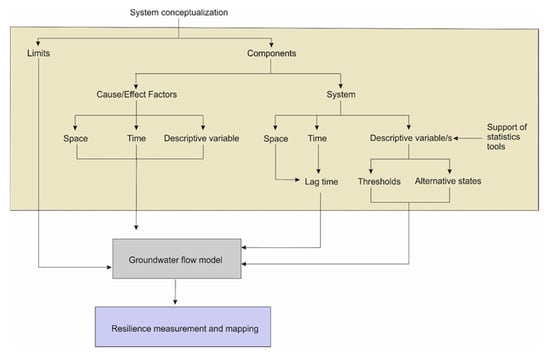
Figure 1.
Flowchart of conceptual, operational and methodological considerations when applied to the aquifer resilience approach. The procedure has three phases: the first one, in beige, describes the data treatment and definition of key variables; the second one, in grey, the groundwater flow model; and the third one, in purple, the resilience measurement and mapping.
In the system conceptualization, the definition of what is inside the system and what is outside the system (drivers) is the first step.
3.1.3. Types of System Responses
Monitoring the aquifer allows analyzing groundwater patterns and different types of aquifer responses can be recognized, that is, equilibrium state and transient state, towards a new equilibrium. The time scale on which an aquifer system adjusts to a new equilibrium is often referred to as “response time” or “lag time” [39]. Two equilibrium states are separated by a threshold. Between one equilibrium state and another, there is a critical threshold. This critical threshold [38] could reach what is called a “tipping point” in which the system breaks down its equilibrium and changes (transforms) into other new equilibrium. Some authors define “transformation” and “adaptation” terms to differentiate those cases in which the system changes its functions and structure and there is no change in them [30]. It may even be a hard task to discriminate between periods of equilibrium and transition. Even in a same equilibrium period, there may be instability to a certain range.
Under a situation of pumping, however, the lag time covers the equilibrium phase plus the threshold (hereinafter we will refer to it as “transition”) crossed to reach the new equilibrium. Therefore, there is an important difference between lag time and aquifer resilience, being the former the time between the beginning of the event and the first changes in the aquifer descriptive variables. Cook and Lamontagne [40] observed that, as there will always be a time lag between groundwater abstraction and reduction in natural discharge, the current apparent health of an exploited aquifer and the ecosystems that depend upon it does not necessarily indicate that the situation will be sustainable in the longer term. In fact, lag time implies a new equilibrium that include the transition period. Figure 2 represents the stages of an aquifer development and the changes observed in the average groundwater level and in the groundwater balance.
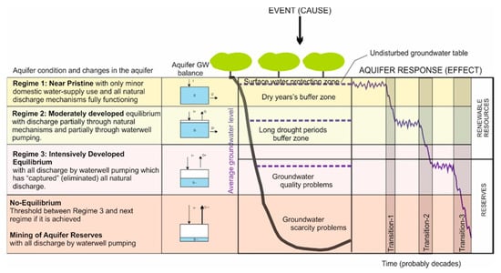
Figure 2.
Stages of groundwater resource development and the implications of storage depletion (adapted from [29]). We assume the piezometric level as descriptive variable. The piezometric level indicates time series of the groundwater system state. The grey area represents the state shift made evident by the changes manifested the system. Transition-1 shows a decrease of the capillary finger with the corresponding affection to terrestrial groundwater dependent ecosystems, as well as changes in surface water and groundwater interactions (discharges to rivers and wetlands reduced). Transition-2 shows changes in groundwater heads (decreasing) with implications on groundwater availability. Transition-3 implies changes in groundwater quality (possibly in groundwater hydrochemical facies) and associated problems of water scarcity. These three transitions also imply changes in hydraulic parameters (Transmissivity and Storability).
However, the aquifer response to pumping does not only affect groundwater quantity but also groundwater quality as will be illustrated in the case study (Section 3.2). The monitoring of both aspects—before, during and after event—jointly with physical and hydrogeological characteristics of the aquifer, are essential to understand aquifer resilience.
3.1.4. Cause/Effect Characterization
The cause/effect factors should be characterized in terms of typology and spatial and temporal dimensions: temporal range, character (discontinuous/continuous), spatial coverage and magnitude (Figure 1).
An isolated event is different from one maintained over time and the adaptation of the system ought to be different. Also, the magnitude of the effects influences the response of the system. Some shocks and stresses, either individually or in combination, might lead to a long-term decline in the aquifer functioning, thus altering its provision of ecosystem services.
An aquifer might be considered in equilibrium under conditions of non-human perturbation. Human interventions imply the presence of processes, which are response to changes in the groundwater system [27].
It should be noticed that “many different shocks and stresses may combine or occur closely together, each impacting the level of resilience at different scales and each requiring separate or integrated measures to reduce the abruptness of downward [development] trends” [41].
3.1.5. Definition of the Descriptive Variable
The descriptive variable is a dependent variable among a set of independent variables that act as disturbing elements in the system, either from a natural or anthropogenic origin and whose measurement helps in the description or quantification of the system’s behavior against disturbances. Examples of descriptive or independent variables commonly used in hydrogeological systems are piezometric levels, spring flows, surface water flows, electric conductivity, pH, temperature or chemical concentrations. These are typically controlled by independent variables such as precipitation, abstractions, evapotranspiration and irrigation returns.
Depending on the specific process to be monitored, the most suitable descriptive variable should be selected. Each disturbance propagates along the system generating a series of changes in response to it. These changes play out by triggering a series of processes that lead to the changes in a series of specific variables that should be observed during a time period long enough to reflect the behavior of the system before, during and after the disturbance. This requires having good quality registers and databases.
Statistical correlations between observed parameters is a useful auxiliary tool to identify relevant variables and evaluate them. For example, t-test, that assess the statistical significance of a selected variable.
3.1.6. Aquifer Resilience Measurement
Aquifer resilience is likely to be measured in temporal dimensions. This temporal scale refers to the time from the beginning of the event until the first transition begins. In fact, the first changes into the first transition imply that the system has already been affected. What we suggest is that it could be possible to predict the moment in which the system may suffer a transition (aquifer deterioration) through the combination of long-term series of descriptive variables of the aquifer’s groundwater patterns and groundwater hydrochemical model. In fact, this integrative model should be able to show the aquifer’s complexity involving a complete compilation of the aquifer knowledge and look for a step further than an estimation of time response, in order to predict internal changes into the groundwater flow and transport system. Machine learning and big data tools could provide additional support to identify groundwater patterns. This will be particularly useful for modelling multiple processes. It is worth considering that the results of the proposed methodology are case-specific and are strongly dependent on the amount of data involved in the process. The model itself represents one of the possible views of the system, not the only one.
One of the problems that arises is due to the fact that events like water abstractions are normally maintained and do not cease in the short term. In most aquifers that are currently being exploited, pumping is a continuous and prolonged event over time, so the analysis of the aquifer’s resilience only makes sense within the framework of identifying the system trend towards a new state of balance. Approaches to this concept have been made in works where the central theme was, for example, the intensive exploitation of groundwater and water mining. In specific cases, resilience has been identified as the time that it would take to recover from pumping. For example, in the Canary Islands and particularly in Gran Canaria and Tenerife, it would range between decades and up to one century [42].
At a local scale and on a temporal scale of days, the analysis of the hydrological resilience of aquifers can be undertaken through diagnostic techniques such as a pumping test. By measuring a dependent variable (water depth in the pumping well and in observation wells) and controlling the independent variables (yield and pumping time), the specific effects of the disturbance could be quantified, as well as the inertia and recovery time and the local hydraulic parameters of the aquifer could be obtained. In a broad sense, an assessment of the resilience of this system points to the pumping that could be made. The major drawback of the use of pumping tests is that they are local and specific in time and space and their extrapolation to greater extensions of the system depends largely on the anisotropy and heterogeneity of the aquifer. The most frequently used procedure to estimate aquifer resilience is based on some type of index.
3.2. Case Study
The selected case study provides an example for the first phase of the procedure explained in Section 3.1. (Figure 1). It is a set of confined coastal aquifers with long-term series analyzed, located around Copenhagen (Denmark). Gejl et al. [8] investigated 1900–2015 series of groundwater quality parameters, pumping rates and groundwater levels in 28 well fields. These authors focused on well fields with a maximum 10-year gap in data and extraction. They also emphasized long time series, using wells that began pumping before 1970 and that have remained operational for more than 30 years with no major changes within the well field that could result in changes in water quality. Extraction and water quality data was available for each well field, not lumped. These criteria are common to analyze aquifer’s resilience.
The aquifer consists of a sand layer (unconfined aquifer), clay (aquitard) and chalk (deep confined aquifer) (Figure 3a), with abundant presence of pyrite [43]. Processes affecting groundwater quality, include oxidation of pyrite, which produces sulphate and iron precipitates and which may release nickel and arsenic [44]. Furthermore, other important processes are also participating in the system’s dynamics: saltwater intrusion and other dissolution/precipitation processes different from the pyrite oxidation above-mentioned. The background concentration of sulphate in groundwater in Denmark ranges from 10 to 30 mg/L.
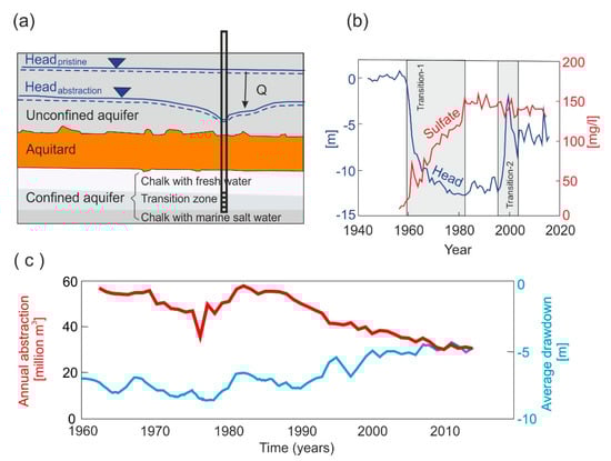
Figure 3.
Case study of a set of confined coastal aquifers around Copenhagen (Denmark) (adapted from [8]). (a) The confined aquifer are generally formed by an upper layer of chalk with freshwater, an intermediate layer of transition zone with Mg and NaCl and a lower layer of Chalk with marine salt water. (b) Potentiometric heads from 1940 until 2014 experienced a 2–14 m decrease in the nearby potentiometric surface compared to the pre-pumping potentiometric surface recordings, meanwhile sulphate concentrations increased from less than 10 mg/L to around 140 mg/L after the maximum extraction period, compared to the earliest water quality parameters. (c) Total extraction since 1962 and the average dra-down at the 28 well fields. Note from 1990, the decrease in annual extraction could be modeled as an exponential decay function.
Aquifer Development
Time-scale dimension for extraction covers a period of around 50 years with the highest water extraction reached in the 1980s (Figure 3c). Extractions are known for each year, so the impact is well quantified. Extractions from the deep confined aquifer caused a small change in the potentiometric surfaces of the shallow unconfined and a large change in the confined aquifer, deriving in an increase of the vertical hydraulic gradient.
4. Results and Discussion
4.1. Identifying the Most Relevant Variables
Descriptive variables are potentiometric surface, vertical gradients and water quality parameters for the wells in the case study. Groundwater extractions are the independent variable since the others vary depending on the extractions and in case of action, it is the only one on which you can intervene.
Identifying these variables as indicators of change was enabled by the follow-up and comparison of other monitored variables (water quality parameters) in the same time interval. Groundwater levels were obtained from monitoring wells close to the studied well field, where the influence from other well fields was expected to be minimal. The final dataset included 3389 samples of water quality analyses for 28 well fields (1940–2 to 2015). This comprises 20,330 individual records of water quality parameters. After processing these data, Gejl et al. [8] observed that the most relevant indicator for water quality was sulphate concentrations because is the process that produces the higher quality problems and the most sensitive to water depletion.
Extraction, groundwater level and water quality data were analyzed jointly [8]. Descriptive variables were chosen based on statistical tools, such as correlations between parameters evaluated by t-tests. Three sub-periods were identified: (a) pre-pumping; (b) the maximum extraction period; (c) 20 years after the maximum extraction period (this is equivalent to three steady stages from our approach separated by two transition periods (Figure 3b)). The authors observe that in (b) the well fields experienced a 2–14 m decrease in the nearby potentiometric surface compared to the first –or pre-pumping—potentiometric surface recordings. Sulphate concentrations increased in 25 out of 27 well fields after the maximum extraction period, compared to the earliest water quality measurements.
4.2. Identification of Thresholds and Lag Time
According to the system’s changes described by the authors, we recognized two transitions (or thresholds) in the time series (extractions, potentiometric surface and sulphate concentrations). A first transition (Transition-1) goes from the pre-pumping conditions to during-pumping conditions (Figure 3b). The associated changes show a steep decrease in the potentiometric surface versus an increase in sulphate concentrations. Meanwhile, the changes associated to Transition-2 show an increase in potentiometric surface versus a stabilization in sulphate concentrations (Figure 3b). The equilibrium state is found first for the potentiometric surface and second, for the sulphate concentration in the Transition-1. Meanwhile in the Transition-2 the only variable that experiences changes is the potentiometric surface. It means that after a potentiometric head decrease of about 13 meters, the sulphate concentration reaches a semi-steady state and thus, the sulphate concentration turns into an independent variable from potentiometric head and, consequently, from extraction. This new steady and independent state for sulphates indicates an irreversible situation.
The lag time estimation is around 40 years (with the groundwater quality deterioration already produced into the aquifer). The Transition-1 appears at the beginning of the 1960s, after around 50 years of aquifers development. This means that the aquifers tolerance to pumping could resist the experienced volumes of extraction (around 55 million m3/yr) without experiencing important changes. Changes in aquifer conditions during that pumping period reveal pyrite oxidation to be a key long term water quality indicator, as observed from calcium and sulfate and calcium content. Therefore, changes in pyrite can indicate (un)sustainable groundwater extraction.
4.3. Aquifer Resilience and Groundwater Sustainability Management
Some aspects are relevant: the aquifer resilience will be maintained as long as the aquifer is under confined conditions. However, if the water quality changes drastically, the aquifer is not resilient to pumping and it can take very long time to come back to the starting water quality conditions. The degree of exploitation determines the conditions of confinement and un-confinement of the aquifers, which determine the hydrodynamic behavior. This means that an important hydrodynamic change will happen the moment the aquifer shifts from a confined to an unconfined state. The self-regulatory capacity will be seriously affected and the aquifers will be exposed to impacts for which they previously had mechanisms to find a new equilibrium.
Some challenges to cope with in the future will be:
- Even though the aquifer’s development could potentially be in an advanced state (perhaps in the regime 3 Figure 2), there are not changes in the aquifer skeleton which could cause subsidence problems.
- The different degree of exploitation or development of wells in some sectors, compared to others in the same aquifer, can generate a compartmentalization in its hydrodynamic operation, observing, for example, different piezometric trends in different sectors for the same time period. This could be interpreted as different states of equilibrium for the same time period.
The measurement of the buffering capacity, resilience or recovery of an ecosystem from a certain disturbance requires not only a good characterization but also a definition of its spatial and temporal dimensions. Yet this is not sufficient. According to Llamas et al. [45], a profound change is needed in the understanding of the mechanisms behind aquifer regime shifts. This aspect is important since it remains unclear how aquifers will respond to current trends of climate patterns and anthropogenic pressures.
Aquifer resilience constitutes an important groundwater related ecosystem service of outstanding value, given its potential to mitigate droughts and assist in emergency situations [46]. In the studied aquifers, an important characteristic that increases their resilience, is their ability to recover from exhaustion situations in certain cases. This ecosystem service, can be of benefit for humans and a service of need/dependence. For this reason, we consider it essential to develop a research line in this area, in which knowledge can be generated through different interested international professional groups. The integration of the concept of resilience in water and ecological management implies working with long-term planning, something that is usually outside the scope of the temporary interest of some political processes and of many research projects. It is not about exhausting an aquifer to learn or know but rather about discovering the limits of response of the system to avoid surpassing them. What is not possible is to undertake a sustainable management of an aquifer without having enough knowledge of the system. Lack of knowledge poses a risk of degrading or destroying the natural heritage and future water security.
We agree with the conclusions by Rockström et al. [47] at a planetary scale. At the aquifer scale, much of the uncertainty in quantifying aquifer resilience is due to our lack of scientific knowledge about: the site specific nature of the biophysical thresholds themselves; the intrinsic uncertainty of how complex systems behave; the ways in which other biophysical processes such as feedback mechanisms interact with the primary control variable; and the uncertainty regarding the allowed time of overshoot for a critical control variable in the aquifer system before a threshold is crossed.
4.4. Limitations and Needs of Further Research
The described approach could be useful for analyzing long-term series of well-known aquifers. Regarding aquifers monitoring, the approach could also be applied for the analysis of big data using GIS technologies. The results will contribute to improve the efficiency of groundwater resource management and will help to concretize the threshold of potential changes in the groundwater flow system.
The most important handicap for this type of studies is the lack of long-term time series and the difficulties to work in the field with monitoring equipment not subject to temporal projects. A well-defined network of monitoring data should be established and controlled by regional governments to guarantee a solid data-base for research and protection of aquifers [33]. Another important challenge is the lack of historical information. In most countries, extraction data records start in the 1960’s, whereas the coverage records for the whole country is not achieved until many years later. Therefore, it is not possible to carry out synchronic studies for different areas.
Modelling aquifer resilience is an open field of work, which needs the support of long time series and potentially big data to guarantee the quality of the analysis and assessment. Machine learning techniques may provide an important support to identify thresholds once the key variables have been defined.
5. Concluding Remarks
An aquifer resilience approach was proposed, starting from an in-depth knowledge of the aquifer. This means either a quantitative or a qualitative understanding of the processes involved in the aquifer’s dynamics. Using a set of key variables, which describe the groundwater patterns, this approach is based on the identification of thresholds of change as an efficient and helpful supporting tool to evaluate sustainable groundwater extractions.
The analysis of the resilience of an aquifer implies an in-depth knowledge of the aquifer system, in its physical aspects (geometry, storage volume, etc.) but also fundamentally, in its dynamic aspects either for qualitative or quantitative processes. We agree with some authors who have identified this aquifer capacity as a latent capacity [48] since it may not manifest itself until a certain moment of stressful conditions.
Knowing the system is not enough to undertake a good management but it is also necessary to identify the surrounding stressors. An aquifer is affected by, for example, droughts, agricultural pollution, groundwater pumping and climate change, both in quality and quantity. These impacts from these stresses can occur individually or simultaneously. Groundwater managers must consider this and act with a proactive response, in which a number of measures is available to mitigate the changes that may occur in the system, before they reach a point of no return.
The identification of thresholds is based on the respective patterns. However, there is no consensus from the scientific community on the usefulness of empirical data to understand ecosystem responses to changes. This remark is open to debate. While in the field of ecology some authors defend that the thresholds for ecological responses to global change do not emerge from empirical data [49], in the hydrogeological sphere, there is no pronouncement on the matter.
The existing indices and indicators to quantify the resilience of a system have been proposed in the field of ecology and are rarely extrapolated to the hydrogeological field. This means that hydrogeology itself must be the area in which the indicators that allow this measure to be achieved have to be generated. The proposed methodology constitutes an approximation but it needs an empirical validation in different types of aquifers. Besides, there is a need to develop methods to understand the join impacts of natural fluctuations and anthropogenic impacts.
It is important to strengthen and develop this line of work of aquifer resilience in order to: (a) achieve an in-depth knowledge of the systems, leading to adopt a more proactive management based on the principle that to prevent is better than to cure; (b) properly manage aquifers where the operating limits have been exceeded, so that these aquifers can continue to provide their services in the future.
Determining aquifer resilience may allow for improved management practices and react before causing irreversible deterioration.
Author Contributions
Conceptualization: Á.d.l.H.-P. Methodology: Á.d.l.H.-P. and J.L.-G. Formal analysis and investigation: Á.d.l.H.-P., H.J.H. and R.N.G. Writing—original draft preparation: Á.d.l.H.-P. Writing—review and editing: Á.d.l.H.-P., B.M., E.L.-G., H.J.H., P.Z.-M., P.M.-S. All authors have read and agreed to the published version of the manuscript.
Funding
This research was funded by the European Commission under the H2020 Programme, NAIAD “Nature Insurance value: Assessment and Demonstration” project (Grant No. 730497).
Institutional Review Board Statement
Not applicable.
Acknowledgments
Authors wish to thank the support received from the Duero Basin Authority (Confederación Hidrográfica del Duero, CHD, in Spanish) to carry out this research and the review and useful comments received from the anonymous reviewers.
Conflicts of Interest
The authors declare no conflict of interest.
References
- SKM. Atlas of Groundwater Dependent Ecosystems. Ecosystems (GDE Atlas), Phase 2. Task 5 Report: Identifying and Mapping GDEs; Australian Government, National Water Commission, CSIRO and SKM: Melbourne, Australia, 2012. Available online: http://www.bom.gov.au/water/groundwater/dge/map.shtml (accessed on 2 February 2020).
- Martínez-Santos, P.; Castaño-Castaño, S.; Hernández-Espriú, A. Revisiting groundwater overdraft based on the experience of the Mancha Occidental Aquifer, Spain. Hydrogeol. J. 2018, 26, 1083–1097. [Google Scholar] [CrossRef]
- Custodio, E. Aquifer overexploitation: What does it mean? Hydrogeol. J. 2002, 10, 254–277. [Google Scholar] [CrossRef]
- Llamas, M.R.; Custodio, E. Intensive use of groundwater: A new situation which demands proactive action. In Intensive Use of Groundwater, Challenges and Opportunities; Llamas, R., Custodio, E., Eds.; Instituto Geológico y Minero de España, Generalitat Valenciana, Fundación Marcelino Botín, A.A. Balkema Publishers: Avereest, The Netherlands, 2003; pp. 13–31. [Google Scholar]
- MASE. Aspectos Hidrológicos, Ambientales, Económicos, Sociales y éticos del Consumo de Reservas de Agua Subterránea en España: Minería del Agua Subterránea en España; [Hydrogeological, Environmental, Economic, Social and Ethical Aspects of Groundwater Reserves Consumption in Spain]; MASE, 2015; pp. 1–490. Available online: https://h2ogeo.upc.edu/images/pdf/proyectos/Empresas/Informe_MASE.pdf (accessed on 2 February 2021).
- Loftis, J.C. Trends in groundwater quality. Hydrol. Process. 1996, 10, 335–355. [Google Scholar] [CrossRef]
- Luczaj, J.A.; Maas, J.; Hart, D.J.; Odekirk, J. Aquifer Drawdown and Recovery in the Northeast Groundwater Management Area, Wisconsin, USA: A Century of Groundwater Use. Geoscience 2017, 7, 11. [Google Scholar] [CrossRef]
- Gejl, R.; Rygaard, M.; Henriksen, H.; Rasmussen, J.; Bjerg, P. Understanding the impacts of groundwater abstraction through long-term trends in water quality. Water Res. 2019, 156, 241–251. [Google Scholar] [CrossRef] [PubMed]
- Goldscheider, N.; Chen, Z.; Auler, A.S.; Bakalowicz, M.; Broda, S.; Drew, D.; Hartmann, J.; Jiang, G.; Moosdorf, N.; Stevanovic, Z.; et al. Global distribution of carbonate rocks and karst water resources. Hydrogeol. J. 2020, 28, 1661–1677. [Google Scholar] [CrossRef]
- Tóth, J. Groundwater as a geologic agent: An overview of the causes, processes, and manifestations. Hydrogeol. J. 1999, 7, 1–14. [Google Scholar] [CrossRef]
- Harvey, T.M.; Arnaud, E.; Meyer, J.R.; Steelman, C.M.; Parker, B.L. Characterizing scales of hydrogeological heterogeneity in ice-marginal sediments in Wisconsin, USA. Hydrogeol. J. 2019, 27, 1949–1968. [Google Scholar] [CrossRef]
- Hinsby, K.; Troldborg, L.; Purtschert, R.; Corcho Alvarado, J.A. Integrated Dynamic Modelling of Tracer Transport and Long Term Groundwater/Surface Water Interaction using four 30 Year 3H Time Series and Multiple Tracers for Groundwater Dating; International Atomic Energy Agency (IAEA): Vienna, Austria, 2006; pp. 73–95. [Google Scholar]
- Henriksen, H.; Troldborg, L.; Højberg, A.L.; Refsgaard, J.C. Assessment of exploitable groundwater resources of Denmark by use of ensemble resource indicators and a numerical groundwater–surface water model. J. Hydrol. 2008, 348, 224–240. [Google Scholar] [CrossRef]
- Custodio, E. Recarga Natural a los Acuíferos, Metodología y Soporte de la Isotopía del Agua. Aplicación a la Planificación Hidrológica y Conocimiento de las Aguas Subterráneas en España [Natural Recharge to Aquifers, Methodology and Support of Water Isotopy. Application to Hydrological Planning and Knowledge of Groundwater in Spain]; Report RAEMIA; CETAQUA, UPC, SUEZ: Cornellà de Llobregat, Spain, 2019. [Google Scholar]
- Sophocleous, M. Environmental implications of intensive use with special regard to streams and wetlands. In Intensive Use of Groundwater, Challenges and Opportunities; Llamas, R., Custodio, E., Eds.; Instituto Geológico y Minero de España, Generalitat Valenciana, Fundación Marcelino Botín; A.A. Balkema Publishers: Avereest, The Netherlands, 2003; pp. 93–112. [Google Scholar]
- Holman, I.P.; Allen, D.M.; Cuthbert, M.O.; Goderniaux, P. Towards best practice for assessing the impacts of climate change on groundwater. Hydrogeol. J. 2011, 20, 1–4. [Google Scholar] [CrossRef]
- Davidson, P. Aquifer Dynamics and Resilience Review; MDC Technical Report No: 12-001; Malborough District Council: Blenheim, New Zealand, 2012. Available online: https://www.marlborough.govt.nz/repository/libraries/id:1w1mps0ir17q9sgxanf9/hierarchy/Documents/Environment/Groundwater/Groundwater%20Reports%202012%20List/AquiferReslienceReport2012.pdf (accessed on 2 February 2020).
- Lapworth, D.J.; Macdonald, A.M.; Tijani, M.N.; Darling, G.; Gooddy, D.C.; Bonsor, H.C.; Araguás-Araguás, L.J. Residence times of shallow groundwater in West Africa: Implications for hydrogeology and resilience to future changes in climate. Hydrogeol. J. 2013, 21, 673–686. [Google Scholar] [CrossRef]
- Henriksen, H.J.; Refsgaard, J.C. Sustainable Groundwater Abstraction—A Review Report; Danmarks og Groenlands Geolo-giske Undersogelse Rapport 2013/30; GEUS: Copenhagen, Denmark, 2013; Available online: https://www.miljoeogressourcer.dk/filer/lix/4048/Sustainable_groundwater_abstraction__GEUS_.pdf (accessed on 2 February 2021).
- Boulay, A.-M.; Bare, J.; Benini, L.; Berger, M.; Lathuillière, M.J.; Manzardo, A.; Margni, M.; Motoshita, M.; Núñez, M.; Pastor, A.V.; et al. The WULCA consensus characterization model for water scarcity footprints: Assessing impacts of water consumption based on available water remaining (AWARE). Int. J. Life Cycle Assess. 2018, 23, 368–378. [Google Scholar] [CrossRef]
- Gejl, R.; Bjerg, P.; Henriksen, H.; Hauschild, M.; Rasmussen, J.; Rygaard, M. Integrating groundwater stress in life-cycle assessments—An evaluation of water abstraction. J. Environ. Manag. 2018, 222, 112–121. [Google Scholar] [CrossRef] [PubMed]
- Gleeson, T.; Wada, Y.; Bierkens, M.F.P.; Van Beek, L.P.H. Water balance of global aquifers revealed by groundwater footprint. Nat. Cell Biol. 2012, 488, 197–200. [Google Scholar] [CrossRef]
- Thomas, B.F. Sustainability indices to evaluate groundwater adaptive management: A case study in California (USA) for the Sustainable Groundwater Management Act. Hydrogeol. J. 2018, 27, 239–248. [Google Scholar] [CrossRef]
- MEA. Millennium Ecosystem Assessment. Ecosystems and Human Well-Being: Synthesis; Island Press: Washington, DC, USA, 2005. [Google Scholar]
- SNEA. Ecosystems and Biodiversity for Human Wellbeing. Spanish National Ecosystem Assessment. Synthesis of Key Findings; Fundación Biodiversidad, Ministerio de Agricultura, Alimentación y Medio Ambiente de España: Madrid, Spain, 2014; Available online: www.Ecomilenio.es (accessed on 5 February 2020).
- Grey, D.; Sadoff, C.W. Sink or Swim? Water security for growth and development. Hydrol. Res. 2007, 9, 545–571. [Google Scholar] [CrossRef]
- Falkenmark, M.; Wang-Erlandsson, L.; Rockström, J. Understanding of water resilience in the Anthropocene. J. Hydrol. 2019, 2, 100009. [Google Scholar] [CrossRef]
- Prathapar, S.A. Quantifying resilience of aquifer. In Proceedings of the IAH Canberra, Canberra, Australia, 14 April 2016; Available online: https://www.researchgate.net/publication/301294416_Quantifying_Resilience_of_Aquifers (accessed on 9 February 2020).
- Foster, S.; Macdonald, A.M. The ‘water security’ dialogue: Why it needs to be better informed about groundwater. Hydrogeol. J. 2014, 22, 1489–1492. [Google Scholar] [CrossRef]
- Walker, B.; Holling, C.S.; Carpenter, S.R.; Kinzig, A.P. Resilience, Adaptability and Transformability in Social-ecological Systems. Ecol. Soc. 2004, 9, 5. [Google Scholar] [CrossRef]
- Land and Ecosystems (WLE) CGIAR Research Program on Water; Sri Lanka International Water Management Institute Colombo. Building Resilience through Sustainable Groundwater Use; International Water Management Institute (IWMI). CGIAR Research Program on Water, Land and Ecosystems (WLE): Colombo, Sri Lanka, 2017. [Google Scholar]
- Galassi, D.M.P.; Lombardo, P.; Fiasca, B.; Di Cioccio, A.; Di Lorenzo, T.; Petitta, M.; Di Carlo, P. Earthquakes trigger the loss of groundwater biodiversity. Sci. Rep. 2015, 4, 6273. [Google Scholar] [CrossRef] [PubMed]
- USGS. Confined and Unconfined Aquifers Respond Differently to Pumping; USGS: Reston, VA, USA, 2001; 14p. Available online: https://pubs.usgs.gov/circ/circ1186/pdf/boxa.pdf (accessed on 8 April 2020).
- Al-Badran, Y.; Schanz, T. Modelling the compaction curve of fine-grained soils. Soils Found. 2014, 54, 426–438. [Google Scholar] [CrossRef]
- Chapman, R.E. Chapter 3. Compaction of Sediment and Sedimentary Rocks and its Consequences. In Developments in Petroleum Science; Elsevier: Amsterdam, The Netherlands, 1983. [Google Scholar]
- López Gutiérrez, J.; García Menéndez, O.; Ballesteros Navarro, B.J.; Díaz Losada, E. Resultados preliminares sobre el origen del la presencia de mercurio en el acuífero de la Plana de Castellón (España). In Proceedings of the International workshop: From Data Gathering and Groundwater Modelling to Integrated Management, Alicante, Spain, 4–8 October 2005; 658p. [Google Scholar]
- IGME. Evaluación del Riesgo de Contaminación de las Aguas Subterráneas por Metales Pesados en el Acuífero de la Plana de Castellón (España); Aplicación al Caso del Mercurio; Sistema de Información Documental del IGME. SID Code 63389; Instituto Geológico y Minero de España: Madrid, Spain, 2007; Volume 2, documentos inéditos. [Google Scholar]
- Dakos, V.; Carpenter, S.R.; Van Nes, E.H.; Scheffer, M. Resilience indicators: Prospects and limitations for early warnings of regime shifts. Philos. Trans. R. Soc. B Biol. Sci. 2015, 370, 20130263. [Google Scholar] [CrossRef]
- Sophocleous, M. Retracted: On Understanding and Predicting Groundwater Response Time. Ground Water 2011, 50, 528–540. [Google Scholar] [CrossRef] [PubMed]
- Cook, P.G.; Lamontagne, S. Assessing and Protecting Water Requirements for Groundwater Dependent Ecosystems; Hydrological Society of South Australia. The Science of Environmental Water Requirements in South Australia, Seminar Proceedings; Hydrological Society of South Australia: Australian Government: Adelaide, Australia, 2002; pp. 49–54. [Google Scholar]
- Mitchell, T.; Harris, K. Resilience: A Risk Management Approach; Overseas Development Institute (ODI): London, UK, 2012; Available online: https://www.odi.org/sites/odi.org.uk/files/odi-assets/publications-opinion-files/7552.pdf (accessed on 5 February 2020).
- Custodio, E.; Cabrera, M.D.C.; Poncela, R.; Puga, L.-O.; Skupien, E.; Del Villar, A. Groundwater intensive exploitation and mining in Gran Canaria and Tenerife, Canary Islands, Spain: Hydrogeological, environmental, economic and social aspects. Sci. Total. Environ. 2016, 557, 425–437. [Google Scholar] [CrossRef] [PubMed]
- Jakobsen, P.R.; Rohde, M.M.; Sheldon, E. Structures and stratigraphy of Danian limestone, eastern Sjælland, Denmark. Geol. Surv. Den. Greenl. Bull. 1969, 38, 21–24. [Google Scholar] [CrossRef]
- Appelo, C.A.; Postma, D. Geochemistry, Groundwater and Pollution; CRC Press: Boca Raton, FL, USA, 2005; Volume 2. [Google Scholar]
- Llamas, M.R.; Martínez-Santos, P.; de la Hera, A. The manifold dimensions of groundwater sustainability: An overview. In The Global Importance of Groundwater in the 21st Century: Proceedings of the International Symposium on Groundwater Sustainability, Alicante, Spain, 24–27 January 2006; Ragone, S., de la Hera, Á., Hernández-Mora, N., Bergkamp, G., McKay, J., Eds.; National Groundwater Association: Westerville, OH, USA, 2007; Volume 3, pp. 105–116. [Google Scholar]
- Vrba, J.; Renaud, F.G. Overview of groundwater for emergency use and human security. Hydrogeol. J. 2016, 24, 273–276. [Google Scholar] [CrossRef]
- Rockström, J.; Steffen, W.; Noone, K.; Persson, Å.; Chapin, F.S.; Lambin, E.; Lenton, T.M.; Scheffer, M.; Folke, C.; Schellnhuber, H.; et al. Planetary boundaries: Exploring the safe operating space for humanity. Ecol. Soc. 2009, 14, 32. [Google Scholar] [CrossRef]
- Angeler, D.G.; Fried-Petersen, H.B.; Allen, C.R.; Garmestani, A.; Twidwell, D.; Chuang, W.-C.; Donovan, V.M.; Eason, T.; Roberts, C.P.; Sundstrom, S.M.; et al. Adaptive capacity in ecosystems. In Advances in Ecological Research; Elsevier: Amsterdam, The Netherlands, 2019; Volume 60, pp. 1–24. [Google Scholar]
- Hillebrand, H.; Donohue, I.; Harpole, W.S.; Hodapp, D.; Kucera, M.; Lewandowska, A.M.; Merder, J.; Montoya, J.M.; Freund, J.A. Thresholds for ecological responses to global change do not emerge from empirical data. Nat. Ecol. Evol. 2020, 4, 1–8. [Google Scholar] [CrossRef] [PubMed]
Publisher’s Note: MDPI stays neutral with regard to jurisdictional claims in published maps and institutional affiliations. |
© 2021 by the authors. Licensee MDPI, Basel, Switzerland. This article is an open access article distributed under the terms and conditions of the Creative Commons Attribution (CC BY) license (http://creativecommons.org/licenses/by/4.0/).