
Upstream Solutions to Downstream Problems: Investing in Rural Natural Infrastructure for Water Quality Improvement and Flood Risk Mitigation


Abstract
:1. Introduction
Durable structural and/or native perennial vegetative measures embedded in a landscape or riverscape that are inspired and supported by nature, restore ecological processes, and deliver multiple environmental benefits to downstream communities.
2. Materials and Methods
3. Results
3.1. Types of NI Measures in Agricultural Landscapes
Categorization of NI by Landscape Position
- Associated with the upland (topographically above a zero- or first-order stream, not in the vicinity of a stream or drainage ditch)
- Associated with artificial drainage structures (topographically above a zero- or first-order stream, hydrologically connected to such a stream by artificial drainage structures)
- Associated with small (first—third order) streams, also with drainage ditches resulting from modification of such streams
- Associated with medium and large (fourth—seventh order) rivers
3.2. Water Quality Benefits of NI Measures
3.3. Flood Mitigation Benefits of Natural Infrastructure Measures
4. Discussion
4.1. NI Performance and Comparison with Other Studies
4.2. Variability in NI Performance
4.3. Land Use and NI
4.4. NI Measures in the Watershed Context
5. Conclusions
Supplementary Materials
Author Contributions
Funding
Institutional Review Board Statement
Informed Consent Statement
Data Availability Statement
Acknowledgments
Conflicts of Interest
References
- New Data Shows Millions of People, Trillions in Property at Risk from Flooding—But Infrastructure Investments Now Can Significantly Lower Flood Risk. Available online: https://www.wri.org/news/release-new-data-shows-millions-people-trillions-property-risk-flooding-infrastructure (accessed on 27 October 2021).
- Bassi, A.M.; Bechauf, R.; Casier, L.; Cutler, E. How Can Investment in Nature Close the Infrastructure Gap? International Institute of Sustainable Development: Winnipeg, Canada, 2021. [Google Scholar]
- Mateo-Sagasta, J.; Zadeh, S.M.; Turral, H. More People, More Food, Worse Water? A Global Review of Water Pollution from Agriculture; Food and Agriculture Organization of the United Nations: Rome, Italy, 2018. [Google Scholar]
- Sobota, D.J.; Compton, J.E.; McCrackin, M.L.; Singh, S. Cost of reactive nitrogen release from human activities to the environment in the United States. Environ. Res. Lett. 2015, 10, 025006. [Google Scholar] [CrossRef]
- McFarland, A.R.; Larsen, L.; Yeshitela, K.; Engida, A.N.; Love, N.G. Guide for using green infrastructure in urban environments for stormwater management. Environ. Sci. Water Res. Technol. 2019, 5, 643–659. [Google Scholar] [CrossRef]
- Qiu, J.; Queiroz, C.; Bennett, E.M.; Cord, A.F.; Crouzat, E.; Lavorel, S.; Maes, J.; Meacham, M.; Norström, A.V.; Peterson, G.D. Land-use intensity mediates ecosystem service tradeoffs across regional social-ecological systems. Ecosyst. People 2021, 17, 264–278. [Google Scholar] [CrossRef]
- Cunniff, S.E. Scaling protection and restoration of natural infrastructure to reduce flood impacts and enhance resilience. Shore Beach 2019, 87, 4. [Google Scholar] [CrossRef]
- Temmerman, S.; Meire, P.; Bouma, T.J.; Herman, P.M.; Ysebaert, T.; De Vriend, H.J. Ecosystem-based coastal defence in the face of global change. Nature 2013, 504, 79–83. [Google Scholar] [CrossRef] [PubMed]
- Howarth, R.W.; Chan, F.; Swaney, D.; Marino, R.; Hayn, M. Role of external inputs of nutrients to aquatic ecosystems in determining prevalence of nitrogen vs. phosphorus limitation of net primary productivity. Biogeochemistry 2021, 154, 293–306. [Google Scholar] [CrossRef]
- Hansen, A.T.; Dolph, C.L.; Foufoula-Georgiou, E.; Finlay, J.C. Contribution of wetlands to nitrate removal at the watershed scale. Nat. Geosci. 2018, 11, 127–132. [Google Scholar] [CrossRef]
- Barber, N.J.; Quinn, P.F. Mitigating diffuse water pollution from agriculture using soft-engineered runoff attenuation features. Area 2012, 44, 454–462. [Google Scholar] [CrossRef]
- Iacob, O.; Rowan, J.S.; Brown, I.; Ellis, C. Evaluating wider benefits of natural flood management strategies: An ecosystem-based adaptation perspective. Hydrol. Res. 2014, 45, 774–787. [Google Scholar] [CrossRef] [Green Version]
- Kelly, S.A.; Takbiri, Z.; Belmont, P.; Foufoula-Georgiou, E. Human amplified changes in precipitation–runoff patterns in large river basins of the Midwestern United States. Hydrol. Earth Syst. Sci. 2017, 21, 5065–5088. [Google Scholar] [CrossRef] [Green Version]
- Schilling, K.E.; Gassman, P.W.; Arenas-Amado, A.; Jones, C.S.; Arnold, J. Quantifying the contribution of tile drainage to basin-scale water yield using analytical and numerical models. Sci. Total Environ. 2019, 657, 297–309. [Google Scholar] [CrossRef]
- Lu, C.; Zhang, J.; Tian, H.; Crumpton, W.G.; Helmers, M.J.; Cai, W.-J.; Hopkinson, C.S.; Lohrenz, S.E. Increased extreme precipitation challenges nitrogen load management to the Gulf of Mexico. Commun. Earth Environ. 2020, 1, 21. [Google Scholar] [CrossRef]
- USGCRP. Chapter 21: Midwest In: Impacts, Risks, and Adaptation in the United States: Fourth National Climate Assessment; Reidmiller, D.R., Avery, C.W., Easterling, D.R., Kunkel, K.E., Lewis, K.L.M., Maycock, T.K., Stewart, B.C., Eds.; U.S. Global Change Research Program: Washington, DC, USA, 2018; pp. 872–940. [Google Scholar]
- Biello, D. Deadly Algae Are Everywhere, Thanks to Agriculture. Scientific American. 2014. Available online: https://www.scientificamerican.com/article/deadly-algae-are-everywhere-thanks-to-agriculture/ (accessed on 28 October 2021).
- Jose, S.; Gold, M.; Zamora, D. Appendix A: Regional Summaries: Midwest. In Agroforestry: Enhancing Resiliency in US Agricultural Landscapes under Changing Conditions; Gen. Tech. Report WO-96; Schoeneberger, M.M., Bentrup, G., Patel-Weynand, T., Eds.; US Department of Agriculture, Forest Service: Washington, DC, USA, 2017; p. 177. [Google Scholar]
- Land, M.; Granéli, W.; Grimvall, A.; Hoffmann, C.C.; Mitsch, W.J.; Tonderski, K.S.; Verhoeven, J.T. How effective are created or restored freshwater wetlands for nitrogen and phosphorus removal? A systematic review. Environ. Evid. 2016, 5, 9. [Google Scholar] [CrossRef] [Green Version]
- Moreno-Mateos, D.; Comín, F.A.; Pedrocchi, C.; Causapé, J. Effect of wetlands on water quality of an agricultural catchment in a semi-arid area under land use transformation. Wetlands 2009, 29, 1104–1113. [Google Scholar] [CrossRef]
- Craft, C.; Vymazal, J.; Kröpfelová, L. Carbon sequestration and nutrient accumulation in floodplain and depressional wetlands. Ecol. Eng. 2018, 114, 137–145. [Google Scholar] [CrossRef]
- Javaheri, A.; Babbar-Sebens, M. On comparison of peak flow reductions, flood inundation maps, and velocity maps in evaluating effects of restored wetlands on channel flooding. Ecol. Eng. 2014, 73, 132–145. [Google Scholar] [CrossRef]
- Ameli, A.A.; Creed, I.F. Does wetland location matter when managing wetlands for watershed-scale flood and drought resilience? J. Am. Water Resour. Assoc. 2019, 55, 529–542. [Google Scholar] [CrossRef]
- Yang, W.; Wang, X.; Liu, Y.; Gabor, S.; Boychuk, L.; Badiou, P. Simulated environmental effects of wetland restoration scenarios in a typical Canadian prairie watershed. Wetl. Ecol. Manag. 2010, 18, 269–279. [Google Scholar] [CrossRef]
- Syswerda, S.; Basso, B.; Hamilton, S.; Tausig, J.; Robertson, G. Long-term nitrate loss along an agricultural intensity gradient in the Upper Midwest USA. Agric. Ecosyst. Environ. 2012, 149, 10–19. [Google Scholar] [CrossRef] [Green Version]
- Dixon, S.J.; Sear, D.A.; Odoni, N.A.; Sykes, T.; Lane, S.N. The effects of river restoration on catchment scale flood risk and flood hydrology. Earth Surf. Process. Landf. 2016, 41, 997–1008. [Google Scholar] [CrossRef]
- Salazar Galán, S.A.; Francés, F.; Komma, J.; Blume, J.; Francke, T.; Bronstert, A.; Blöschl, G. A comparative analysis of the effectiveness of flood management measures based on the concept of retaining water in the landscape in different European hydro-climatic regions. Nat. Hazards Earth Syst. Sci. 2012, 12, 3287–3306. [Google Scholar] [CrossRef] [Green Version]
- Iacob, O.; Brown, I.; Rowan, J. Natural flood management, land use and climate change trade-offs: The case of Tarland catchment, Scotland. Hydrol. Sci. J. 2017, 62, 1931–1948. [Google Scholar] [CrossRef] [Green Version]
- Váňová, V.; Langhammer, J. Modelling the impact of land cover changes on flood mitigation in the upper Lužnice basin. J. Hydrol. Hydromech. 2011, 59, 262–274. [Google Scholar] [CrossRef] [Green Version]
- Culman, S.W.; Snapp, S.S.; Ollenburger, M.; Basso, B.; DeHaan, L.R. Soil and water quality rapidly responds to the perennial grain Kernza wheatgrass. Agron. J. 2013, 105, 735–744. [Google Scholar] [CrossRef] [Green Version]
- McIsaac, G.F.; David, M.B.; Mitchell, C.A. Miscanthus and switchgrass production in central Illinois: Impacts on hydrology and inorganic nitrogen leaching. J. Environ. Qual. 2010, 39, 1790–1799. [Google Scholar] [CrossRef] [Green Version]
- Cibin, R.; Trybula, E.; Chaubey, I.; Brouder, S.M.; Volenec, J.J. Watershed-scale impacts of bioenergy crops on hydrology and water quality using improved SWAT model. GCB Bioenergy 2016, 8, 837–848. [Google Scholar] [CrossRef]
- Nicholson, A.R.; O‘Donnell, G.M.; Wilkinson, M.E.; Quinn, P.F. The potential of runoff attenuation features as a Natural Flood Management approach. J. Flood Risk Manag. 2020, 13, e12565. [Google Scholar] [CrossRef] [Green Version]
- Metcalfe, P.; Beven, K.; Hankin, B.; Lamb, R. A new method, with application, for analysis of the impacts on flood risk of widely distributed enhanced hillslope storage. Hydrol. Earth Syst. Sci. 2018, 22, 2589–2605. [Google Scholar] [CrossRef] [Green Version]
- Fleischer, S.; Gustafson, A.; Joelsson, A.; Pansar, J.; Stibe, L. Nitrogen removal in created ponds. Ambio 1994, 23, 349–357. Available online: http://www.jstor.org/stable/4314235 (accessed on 29 October 2021).
- Ibrahim, Y.A.; Amir-Faryar, B. Strategic insights on the role of farm ponds as nonconventional stormwater management facilities. J. Hydrol. Eng. 2018, 23, 04018023. [Google Scholar] [CrossRef]
- Chrétien, F.; Gagnon, P.; Thériault, G.; Guillou, M. Performance analysis of a wet-retention pond in a small agricultural catchment. J. Environ. Eng. 2016, 142, 04016005. [Google Scholar] [CrossRef]
- Mitsch, W.J.; Day, J.W., Jr. Restoration of wetlands in the Mississippi–Ohio–Missouri (MOM) River Basin: Experience and needed research. Ecol. Eng. 2006, 26, 55–69. [Google Scholar] [CrossRef]
- Groh, T.A.; Gentry, L.E.; David, M.B. Nitrogen removal and greenhouse gas emissions from constructed wetlands receiving tile drainage water. J. Environ. Qual. 2015, 44, 1001–1010. [Google Scholar] [CrossRef] [PubMed] [Green Version]
- Walters, K.M.; Babbar-Sebens, M. Using climate change scenarios to evaluate future effectiveness of potential wetlands in mitigating high flows in a Midwestern U.S. watershed. Ecol. Eng. 2016, 89, 80–102. [Google Scholar] [CrossRef] [Green Version]
- Jaynes, D.B.; Isenhart, T.M. Reconnecting tile drainage to riparian buffer hydrology for enhanced nitrate removal. J. Environ. Qual. 2014, 43, 631–638. [Google Scholar] [CrossRef] [PubMed] [Green Version]
- Groh, T.A.; Davis, M.P.; Isenhart, T.M.; Jaynes, D.B.; Parkin, T.B. In Situ denitrification in saturated riparian buffers. J. Environ. Qual. 2019, 48, 376–384. [Google Scholar] [CrossRef] [PubMed] [Green Version]
- Zak, D.; Stutter, M.; Jensen, H.S.; Egemose, S.; Carstensen, M.V.; Audet, J.; Strand, J.A.; Feuerbach, P.; Hoffmann, C.C.; Christen, B. An assessment of the multifunctionality of integrated buffer zones in Northwestern Europe. J. Environ. Qual. 2019, 48, 362–375. [Google Scholar] [CrossRef] [Green Version]
- Castaldelli, G.; Soana, E.; Racchetti, E.; Vincenzi, F.; Fano, E.A.; Bartoli, M. Vegetated canals mitigate nitrogen surplus in agricultural watersheds. Agric. Ecosyst. Environ. 2015, 212, 253–262. [Google Scholar] [CrossRef]
- Pierobon, E.; Castaldelli, G.; Mantovani, S.; Vincenzi, F.; Fano, E.A. Nitrogen removal in vegetated and unvegetated drainage ditches impacted by diffuse and point sources of pollution. CLEAN-Soil Air Water 2013, 41, 24–31. [Google Scholar] [CrossRef]
- Taylor, J.; Moore, M.; Speir, S.L.; Testa, S. Vegetated ditch habitats provide net nitrogen sink and phosphorus storage capacity in agricultural drainage networks despite senescent plant leaching. Water 2020, 12, 875. [Google Scholar] [CrossRef] [Green Version]
- Schilling, K.E.; Streeter, M.T.; Clair, M.S.; Meissen, J. Subsurface nutrient processing capacity in agricultural roadside ditches. Sci. Total Environ. 2018, 637, 470–479. [Google Scholar] [CrossRef]
- Klocker, C.A.; Kaushal, S.S.; Groffman, P.M.; Mayer, P.M.; Morgan, R.P. Nitrogen uptake and denitrification in restored and unrestored streams in urban Maryland, USA. Aquat. Sci. 2009, 71, 411–424. [Google Scholar] [CrossRef]
- Newcomer Johnson, T.A.; Kaushal, S.S.; Mayer, P.M.; Smith, R.M.; Sivirichi, G.M. Nutrient retention in restored streams and rivers: A global review and synthesis. Water 2016, 8, 116. [Google Scholar] [CrossRef] [Green Version]
- Newcomer Johnson, T.A.; Kaushal, S.S.; Mayer, P.M.; Grese, M.M. Effects of stormwater management and stream restoration on watershed nitrogen retention. Biogeochemistry 2014, 121, 81–106. [Google Scholar] [CrossRef]
- Liu, Y.; Gebremeskel, S.; de Smedt, F.; Hoffmann, L.; Pfister, L. Simulation of flood reduction by natural river rehabilitation using a distributed hydrological model. Hydrol. Earth Syst. Sci. 2004, 8, 1129–1140. [Google Scholar] [CrossRef]
- Hammersmark, C.T.; Rains, M.C.; Mount, J.F. Quantifying the hydrological effects of stream restoration in a montane meadow, northern California, USA. River Res. Appl. 2008, 24, 735–753. [Google Scholar] [CrossRef]
- Speir, S.L.; Tank, J.L.; Mahl, U.H. Quantifying denitrification following floodplain restoration via the two-stage ditch in an agricultural watershed. Ecol. Eng. 2020, 155, 105945. [Google Scholar] [CrossRef]
- Hanrahan, B.R.; Tank, J.L.; Dee, M.M.; Trentman, M.T.; Berg, E.M.; McMillan, S.K. Restored floodplains enhance denitrification compared to naturalized floodplains in agricultural streams. Biogeochemistry 2018, 141, 419–437. [Google Scholar] [CrossRef]
- Dee, M.M.; Tank, J.L. Inundation time mediates denitrification end products and carbon limitation in constructed floodplains of an agricultural stream. Biogeochemistry 2020, 149, 141–158. [Google Scholar] [CrossRef]
- Lowrance, R.; Altier, L.S.; Newbold, J.D.; Schnabel, R.R.; Groffman, P.M.; Denver, J.M.; Correll, D.L.; Gilliam, J.W.; Robinson, J.L.; Brinsfield, R.B. Water quality functions of riparian forest buffers in Chesapeake Bay watersheds. Environ. Manag. 1997, 21, 687–712. Available online: https://repository.si.edu/bitstream/handle/10088/17707/serc_Lowrance_etal_1997_EnvironManage_21_687_712.pdf (accessed on 29 October 2021). [CrossRef] [PubMed]
- Newbold, J.D.; Herbert, S.; Sweeney, B.W.; Kiry, P.; Alberts, S.J. Water Quality Functions of a 15-Year-Old Riparian Forest Buffer System 1. JAWRA J. Am. Water Resour. Assoc. 2010, 46, 299–310. [Google Scholar] [CrossRef]
- Peterjohn, W.T.; Correll, D.L. Nutrient dynamics in an agricultural watershed: Observations on the role of a riparian forest. Ecology 1984, 65, 1466–1475. [Google Scholar] [CrossRef]
- Pinay, G.; Roques, L.; Fabre, A. Spatial and temporal patterns of denitrification in a riparian forest. J. Appl. Ecol. 1993, 581–591. [Google Scholar] [CrossRef]
- Anderson, B.; Rutherfurd, I.; Western, A. An analysis of the influence of riparian vegetation on the propagation of flood waves. Environ. Model. Softw. 2006, 21, 1290–1296. [Google Scholar] [CrossRef]
- Forshay, K.J.; Stanley, E.H. Rapid nitrate loss and denitrification in a temperate river floodplain. Biogeochemistry 2005, 75, 43–64. [Google Scholar] [CrossRef]
- Acreman, M.; Riddington, R.; Booker, D. Hydrological impacts of floodplain restoration: A case study of the River Cherwell, UK. Hydrol. Earth Syst. Sci. 2003, 7, 75–85. [Google Scholar] [CrossRef] [Green Version]
- Ahilan, S.; Guan, M.; Sleigh, A.; Wright, N.; Chang, H. The influence of floodplain restoration on flow and sediment dynamics in an urban river. J. Flood Risk Manag. 2018, 11, S986–S1001. [Google Scholar] [CrossRef]
- Clilverd, H.; Thompson, J.; Heppell, C.; Sayer, C.; Axmacher, J. Coupled hydrological/hydraulic modelling of river restoration impacts and floodplain hydrodynamics. River Res. Appl. 2016, 32, 1927–1948. [Google Scholar] [CrossRef]
- Golden, H.E.; Rajib, A.; Lane, C.R.; Christensen, J.R.; Wu, Q.; Mengistu, S. Non-floodplain wetlands affect watershed nutrient dynamics: A critical review. Environ. Sci. Technol. 2019, 53, 7203–7214. [Google Scholar] [CrossRef]
- Wallace, J.; Waltham, N.J. On the potential for improving water quality entering the Great Barrier Reef lagoon using constructed wetlands. Mar. Pollut. Bull. 2021, 170, 112627. [Google Scholar] [CrossRef]
- Natho, S.; Tschikof, M.; Bondar-Kunze, E.; Hein, T. Modeling the effect of enhanced lateral connectivity on nutrient retention capacity in large river floodplains: How much connected floodplain do we need? Front. Environ. Sci. 2020, 8, 74. [Google Scholar] [CrossRef]
- Vidon, P.G.; Welsh, M.K.; Hassanzadeh, Y.T. Twenty years of riparian zone research (1997–2017): Where to next? J. Environ. Qual. 2019, 48, 248–260. [Google Scholar] [CrossRef] [PubMed]
- Hill, A.R. Groundwater nitrate removal in riparian buffer zones: A review of research progress in the past 20 years. Biogeochemistry 2019, 143, 347–369. [Google Scholar] [CrossRef]
- Wilkinson, M.E.; Addy, S.; Quinn, P.F.; Stutter, M. Natural flood management: Small-scale progress and larger-scale challenges. Scott. Geogr. J. 2019, 135, 23–32. [Google Scholar] [CrossRef]
- Dadson, S.J.; Hall, J.W.; Murgatroyd, A.; Acreman, M.; Bates, P.; Beven, K.; Heathwaite, L.; Holden, J.; Holman, I.P.; Lane, S.N.; et al. A restatement of the natural science evidence concerning catchment-based ‘natural’ flood management in the UK. Proc. R. Soc. A Math. Phys. Eng. Sci. 2017, 473, 20160706. [Google Scholar] [CrossRef] [Green Version]
- Nilsson, C.; Riis, T.; Sarneel, J.M.; Svavarsdóttir, K. Ecological restoration as a means of managing inland flood hazards. BioScience 2018, 68, 89–99. [Google Scholar] [CrossRef]
- Crumpton, W.G.; Stenback, G.A.; Fisher, S.W.; Stenback, J.Z.; Green, D.I. Water Quality Performance of Wetlands Receiving Nonpoint-Source Nitrogen Loads: Nitrate and Total Nitrogen Removal Efficiency and Controlling Factors. J. Environ. Qual. 2020, 49, 735–744. [Google Scholar] [CrossRef] [PubMed] [Green Version]
- Haque, A.; Ali, G.; Badiou, P. Hydrological dynamics of prairie pothole wetlands: Dominant processes and landscape controls under contrasted conditions. Hydrol. Process. 2018, 32, 2405–2422. [Google Scholar] [CrossRef]
- McLellan, E.L.; Schilling, K.E.; Wolter, C.F.; Tomer, M.D.; Porter, S.A.; Magner, J.A.; Smith, D.R.; Prokopy, L.S. Right practice, right place: A conservation planning toolbox for meeting water quality goals in the Corn Belt. J. Soil Water Conserv. 2018, 73, 29A–34A. [Google Scholar] [CrossRef] [Green Version]
- Lien, E.; Magner, J. Engineered biosystem treatment trains: A review of agricultural nutrient sequestration. Invent. J. Res. Technol. Eng. Manag. 2017, 1, 5–10. [Google Scholar]
- Goeller, B.C.; Febria, C.M.; McKergow, L.A.; Harding, J.S.; Matheson, F.E.; Tanner, C.C.; McIntosh, A.R. Combining tools from edge-of-field to in-stream to attenuate reactive nitrogen along small agricultural waterways. Water 2020, 12, 383. [Google Scholar] [CrossRef] [Green Version]
- Mendes, L.R.D. Nitrogen Removal from Agricultural Subsurface Drainage by Surface-Flow Wetlands: Variability. Processes 2021, 9, 156. [Google Scholar] [CrossRef]
- Hankin, B.; Metcalfe, P.; Beven, K.; Chappell, N.A. Integration of hillslope hydrology and 2D hydraulic modelling for natural flood management. Hydrol. Res. 2019, 50, 1535–1548. [Google Scholar] [CrossRef] [Green Version]


| Metric (Units) | Number of Studies Using Metric | Number of NI Measures for Which Metric Is Used | |
|---|---|---|---|
| Flood Mitigation | Peak flow reduction (%) | 30 | 10 |
| Flow velocity (m s−1) | 6 | 6 | |
| Surface runoff (mm h−1 or l s−1) | 6 | 4 | |
| Flood depth/flood height (m) | 4 | 2 | |
| Flood area (m2) | 2 | 2 | |
| Flood duration (h) | 2 | 2 | |
| Storage capacity (m3) | 4 | 3 | |
| Time to peak (h) | 3 | 3 | |
| Changes in baseflow (%) | 1 | 1 | |
| Number of flood events | 1 | 1 | |
| Time to base flow (h) | 1 | 1 | |
| Nitrogen Mitigation | Nitrogen removal rate in kg ha−1 yr−1 | 38 | 15 |
| Nitrogen removal rate, variable metrics * | 11 | 6 | |
| Concentration reduction (%) | 9 | 6 | |
| Denitrification potential (ug N g−1 h−1) | 2 | 4 | |
| Denitrification enzyme activity (ng g−1 h−1) | 1 | 1 | |
| N mineralization rate (μmol N m−2 d−1) | 1 | 1 |
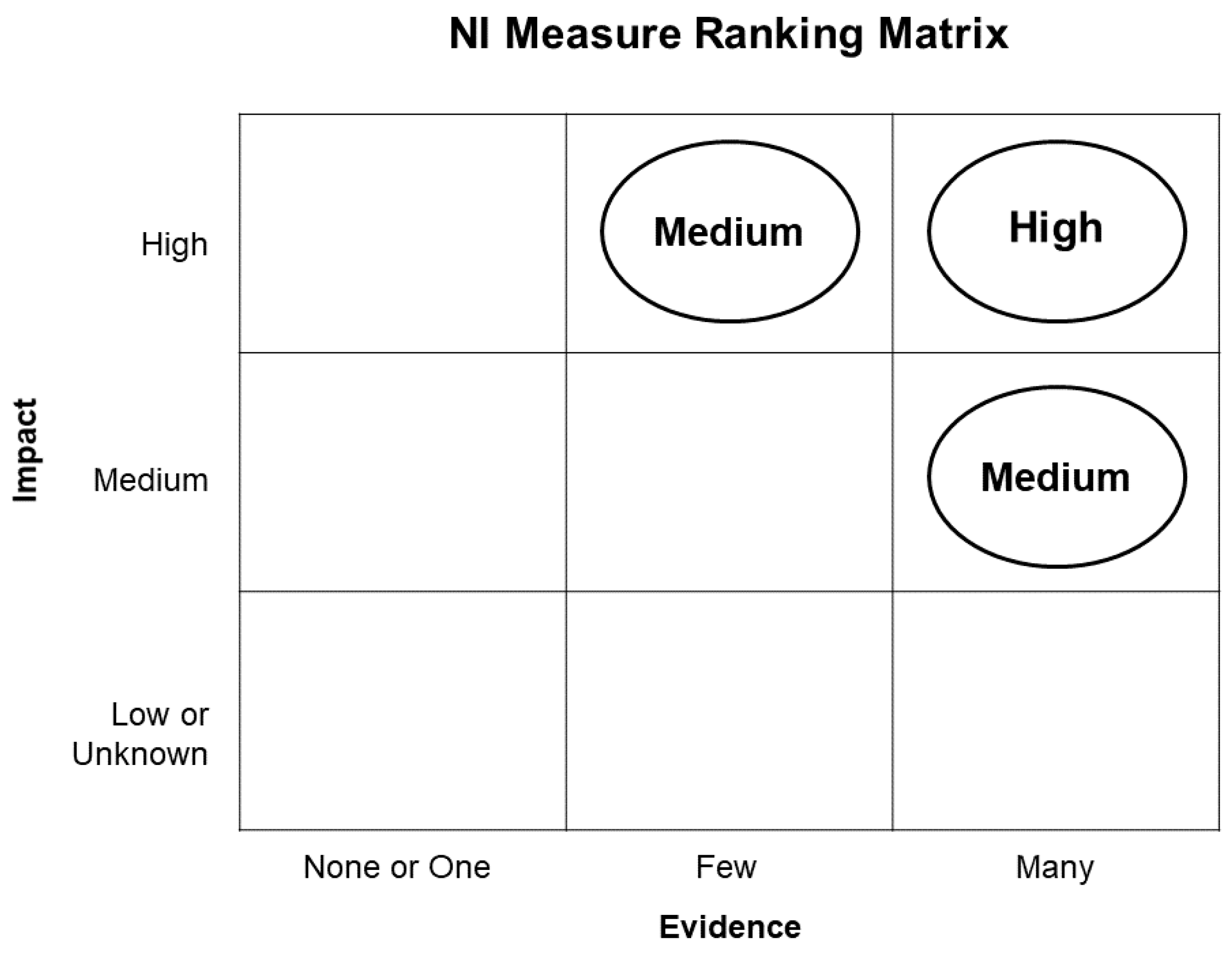
| Strength of Evidence (# of Publications) | Measure Effectiveness | |
|---|---|---|
| None | Water quality, reported as kg N ha−1 yr−1 reduction in nitrogen load | Unknown |
| Low = less than 500 kg N ha−1 yr−1 | ||
| One | Medium = 500–1000 kg N ha−1 yr−1 | |
| High = greater than 1000 kg N ha−1 yr−1 | ||
| Few (2) | Flood risk reduction, reported as % reduction in peak flow | Unknown |
| Low = less than 15% | ||
| Many (3 or more) | Medium = 15–25% | |
| High = greater than 25% | ||
| Landscape Position | ||
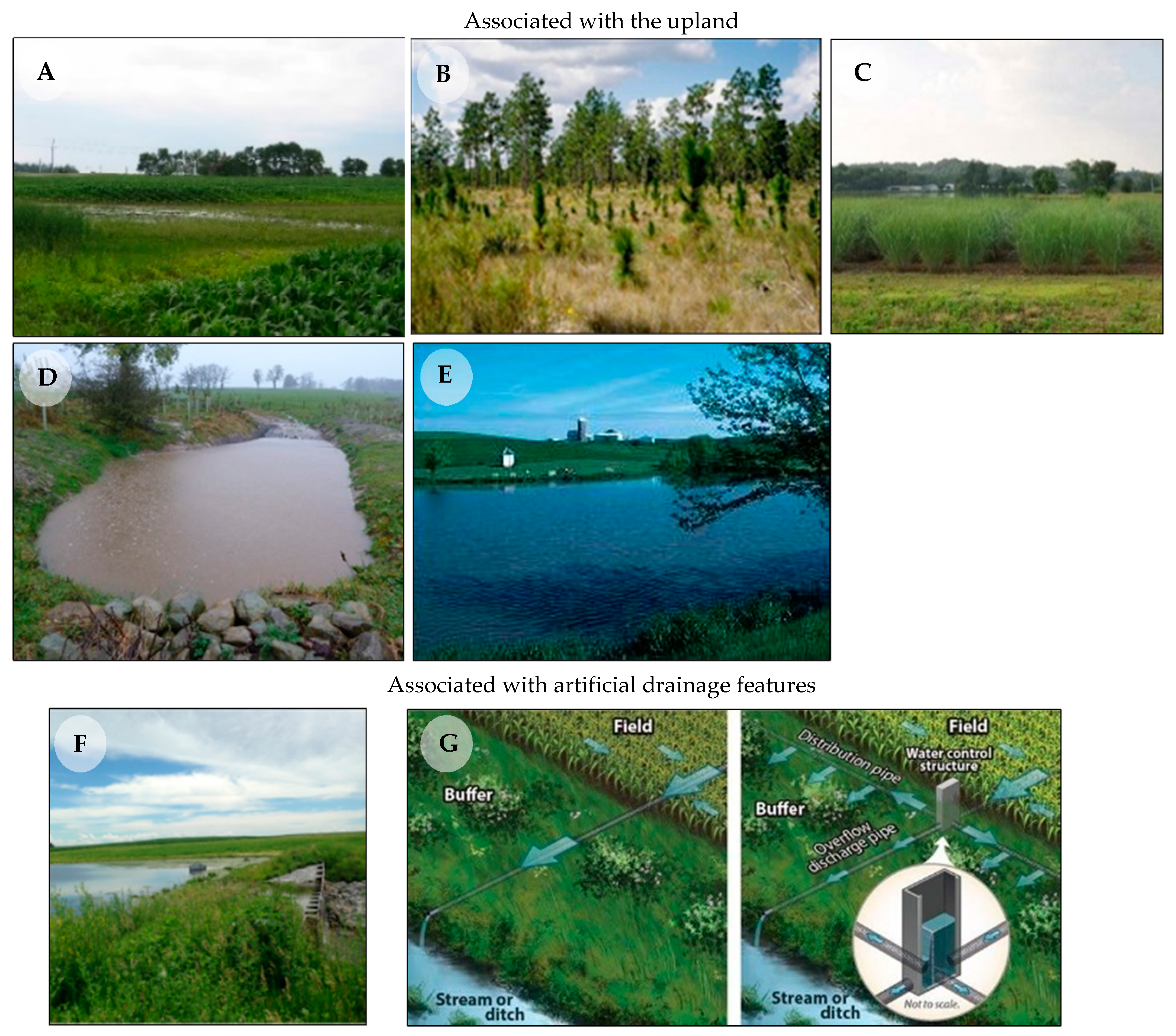
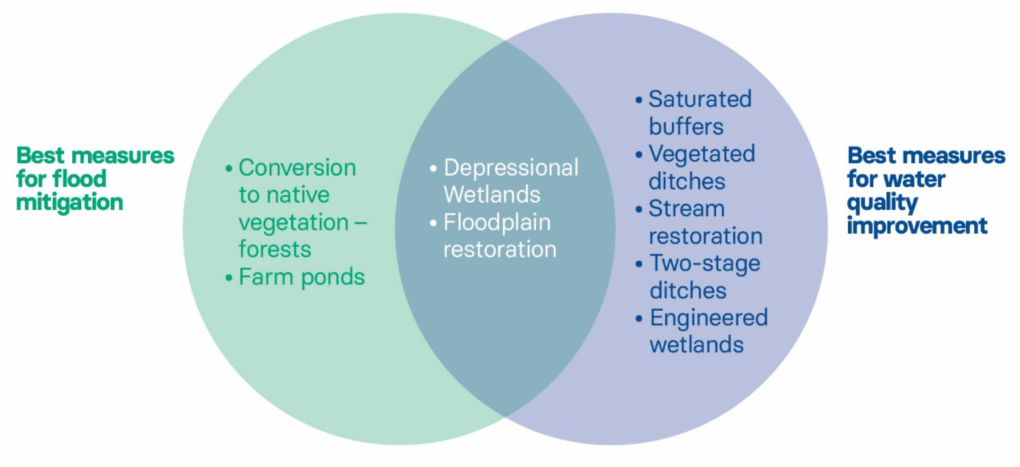
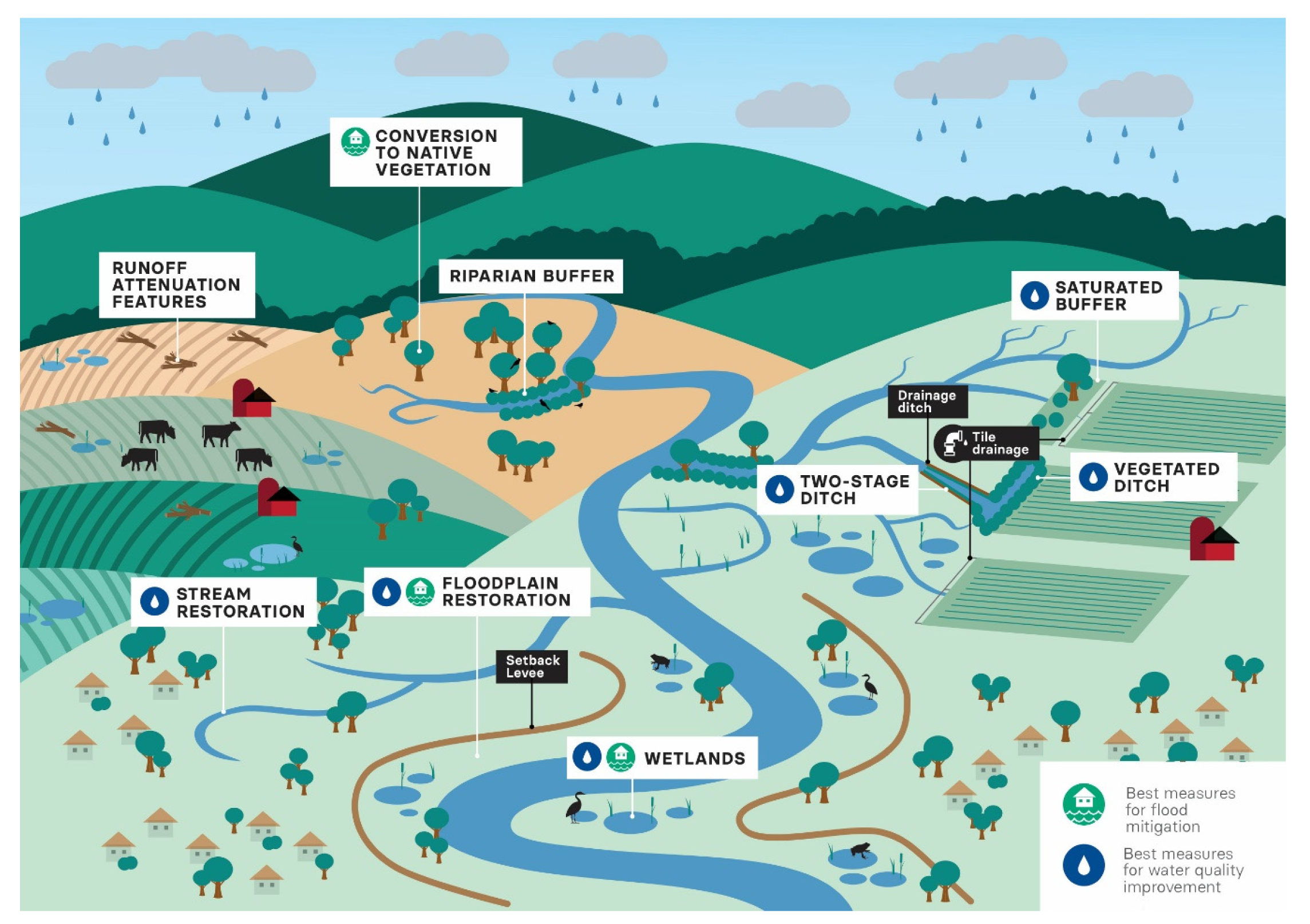
| Associated with the upland | Wetlands—Depressional | Sometimes described as “isolated” wetlands. Most are shallow with depths <1 m and a median size of 0.16 ha, but they can be as large as several hundred hectares. See Figure 2A. |
| Conversion of cropland to native vegetation—forest or grasses | Land use change that converts cropland to forest vegetation or to grass vegetation (including prairie, perennial crops and pasture). See Figure 2B and Figure 2C. | |
| Runoff attenuation features (RAF) | Used primarily in the U.K. and Europe, RAFs intercept overland flow and temporarily store water behind small “leaky “dams over a period of 4–24 h. See Figure 2D. | |
| Farm ponds | Impoundments that are intended for long term storage of water for livestock and/or fishing. They can be constructed with an embankment/berm or dugout out of the earth to fill with water. See Figure 2E. | |
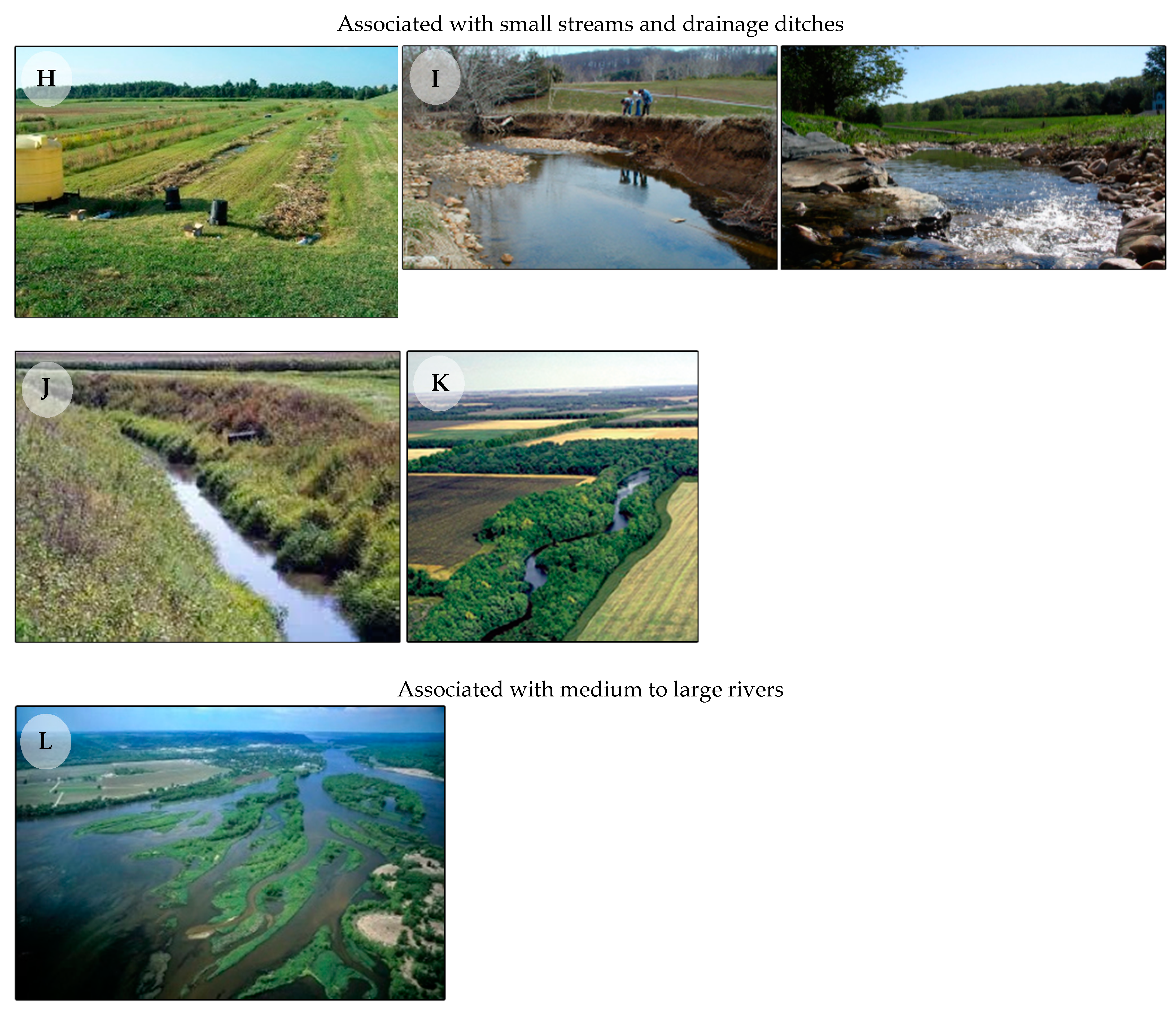
| Associated with artificial drainage structures | Wetlands—engineered | Wetlands constructed where wetlands did not exist before, typically by creating an embankment to intercept the flow from the outlets of artificial drainage structures such as tile drains. They are usually much larger than depressional wetlands and intercept a much larger drainage area. See Figure 2F. |
| Saturated buffers | Used in the U.S.A. where tile drains bypass riparian buffers. They are constructed with a perforated distribution pipe to spread drainage water laterally across the buffer subsurface to promote denitrification. See Figure 2G. | |
| Associated with small streams and drainage ditches | Vegetated ditches | Drainage ditches are planted with grasses or other vegetation to reduce sediment and nutrient pollution. See Figure 2H. |
| Stream restoration | Restoring the geomorphic structure of the stream by raising the stream bed, installing meanders to a channelized stream, re-grading the stream channel, reconnecting oxbows, etc. See Figure 2I. | |
| Two-stage ditches | Modified drainage ditches that have two “benches” on either side of the channel that function as floodplains. Pipes or tile drains empty onto the constructed floodplain rather than directly into the ditch. See Figure 2J. | |
| Riparian forest buffers | Forested areas (natural or re-established) separating streams or rivers from adjacent agricultural land. See Figure 2K. | |
| Associated with larger streams and rivers | Floodplain restoration | Reconnecting the main channel with the floodplain to allow for periodic inundation. It may occur as part of modifications to levees (levee removal, breaching or setback) or in areas without levees. Floodplain restoration is often associated with reconnection of river flows to previously disconnected wetlands (oxbow restoration) and/or planting of native vegetation (e.g., forested floodplain restoration). See Figure 2L. |
| Water Quality | Flood Mitigation | |||||
|---|---|---|---|---|---|---|
| NI Measure Name | Evidence; Impact | Nitrogen loss reduction, average; range (kg ha−1 yr−1) | Evidence; Impact | Peak flow reduction, average; range (%) | Watershed size (km2) | Storm size (AEP) |
| Upland natural infrastructure | ||||||
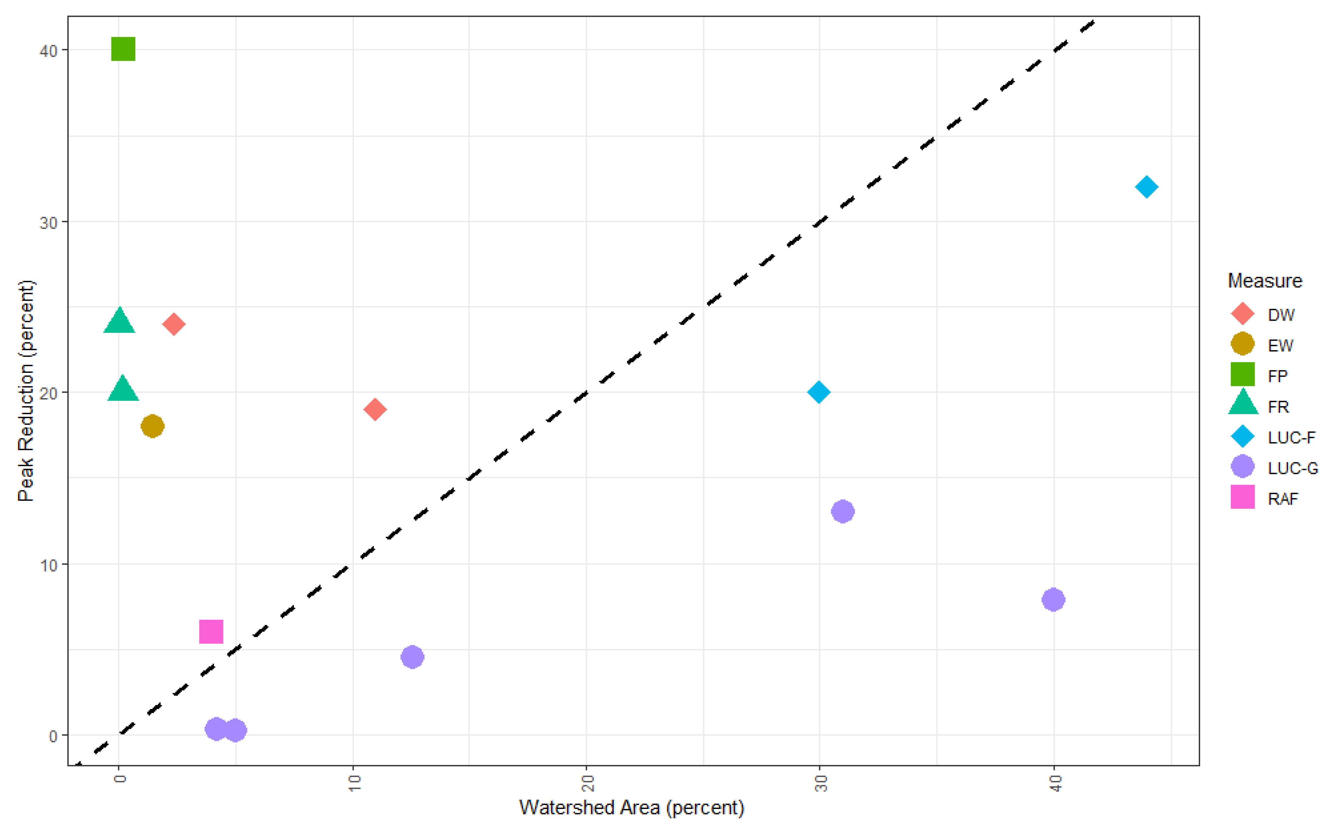
| Wetland—depressional | Many; High | 1113; 37–1810 kg ha−1 yr−1 [19,20,21] | Many; High | 26; 14–41% [22,23,24] | 23–886 km2 [22,23,24] | 1, 10, 39% AEP [22,23] |
| Conversion of cropland to native vegetation—forest | One; Low | 56; 51–61 kg ha−1 yr−1 [25] | Many; High | 27; 19–34% [26,27,28,29] | 25–954 km2 [26,27,28,29] | 1, 5, 10% AEP [28,29] |
| Conversion of cropland to native vegetation—grasses | Many; Low | 55; 29–120 kg ha−1 yr−1 [25,30,31] | Few; Low | 10; 5–14% [29,32] | 943–2089 km2 [29,32] | 1, 5, 10% AEP [29] |
| Runoff attenuation features | None; Unknown | Typical designs do not attenuate nutrients [11] | Many; Low | 9; 3–30% [27,33,34] | 6–954 km2 [27,33,34] | 39% AEP [33] |
| Farm ponds | One; Medium | N/A; 73–7000 kg ha−1 yr−1 [35] | Few; High | 38; 13–55% [36,37] | 0.231–1050 km2 [36,37] | 10, 39% AEP [36] |
| Associated with artificial drainage structures | ||||||
| Wetlands—engineered | Many; Medium | 646; 97–1810 kg ha−1 yr−1 [19,38,39] | One; Medium | 17; 15–20% [40] | 420 km2 [40] | Unknown |
| Saturated buffers | Many; Medium | 706; 60–2190 kg ha−1 yr−1 [41,42,43] | None; Unknown | No peer reviewed studies. | - | - |
| Associated with small streams and drainage ditches | ||||||
| Vegetated ditches | Many; High | 1189; 150–2263 kg ha−1 yr−1 [44,45,46,47] | None; Unknown | No peer reviewed studies. | - | - |
| Stream Restoration | Many; High | 2818; 47–10183 kg ha−1 yr−1 [48,49,50] | Few; Medium | 17; 13–25% [51,52] | 480 km2 [51] | 20–39% AEP [52] |
| Two-stage ditches | Many; Medium | 661; 62–1664 kg ha−1 yr−1 [53,54,55] | None; Unknown | No peer reviewed studies. | - | - |
| Riparian forest buffers | Many; Low | 89; 11–285 kg ha−1 yr−1 [56,57,58,59] | One; Medium | 20% [60] | Unknown | 1, 39% AEP [60] |
| Associated with larger streams and rivers | ||||||
| Floodplain restoration | Many; Medium | 596; 20–1226 kg ha−1 yr−1 [38,50,61] | Many; Medium | 17; 10–24% [62,63,64] | 115–901 km2 [62,63,64] | 1, 2, 4, 7, 10, 20, 39% AEP [62,63] |
Publisher’s Note: MDPI stays neutral with regard to jurisdictional claims in published maps and institutional affiliations. |
© 2021 by the authors. Licensee MDPI, Basel, Switzerland. This article is an open access article distributed under the terms and conditions of the Creative Commons Attribution (CC BY) license (https://creativecommons.org/licenses/by/4.0/).
Share and Cite
Suttles, K.M.; Eagle, A.J.; McLellan, E.L. Upstream Solutions to Downstream Problems: Investing in Rural Natural Infrastructure for Water Quality Improvement and Flood Risk Mitigation. Water 2021, 13, 3579. https://doi.org/10.3390/w13243579
Suttles KM, Eagle AJ, McLellan EL. Upstream Solutions to Downstream Problems: Investing in Rural Natural Infrastructure for Water Quality Improvement and Flood Risk Mitigation. Water. 2021; 13(24):3579. https://doi.org/10.3390/w13243579
Chicago/Turabian StyleSuttles, Kelly M., Alison J. Eagle, and Eileen L. McLellan. 2021. "Upstream Solutions to Downstream Problems: Investing in Rural Natural Infrastructure for Water Quality Improvement and Flood Risk Mitigation" Water 13, no. 24: 3579. https://doi.org/10.3390/w13243579
APA StyleSuttles, K. M., Eagle, A. J., & McLellan, E. L. (2021). Upstream Solutions to Downstream Problems: Investing in Rural Natural Infrastructure for Water Quality Improvement and Flood Risk Mitigation. Water, 13(24), 3579. https://doi.org/10.3390/w13243579