
Study of Impact of Cloud-Seeding on Intensity-Duration-Frequency (IDF) Curves of Sharjah City, the United Arab Emirates


1
Dubai Campus, Heriot-Watt University, Dubai Knowledge Park, Dubai P.O. Box 38103, United Arab Emirates
2
School of Energy, Geoscience, Infrastructure and Society (EGIS), Heriot-Watt University, Edinburgh EH14 4AS, UK
*
Author to whom correspondence should be addressed.
Water 2021, 13(23), 3363; https://doi.org/10.3390/w13233363
Submission received: 5 November 2021
/
Revised: 24 November 2021
/
Accepted: 25 November 2021
/
Published: 27 November 2021
(This article belongs to the Section Hydrology)
Abstract
:Despite the availability of some studies related to rainfall characteristics in Sharjah city and the UAE, very few of these studies have investigated any causal link between recent cloud-seeding missions and the increasing rainfall intensities and urban floods being experienced. This study has assessed the impact of cloud-seeding operations that started in 2010 on the IDF curves of Sharjah city, The UAE. Hourly rainfall data spanning between 2010 and 2020 available at three stations, namely Sharjah Airport, Al Dhaid, and Mleiha, and provided by the National Center of Meteorology were used. To allow comparison with the pre-cloudseeding (2010) era, these records were extended back to 1992 using the much longer data available at Dubai Airport with the aid of the Self-organizing map approach. The developed IDF curves showed an apparent increase in rainfall intensities after implementing the cloud-seeding missions. In addition, the estimated mean rainfall intensities for three regions of the city were also much higher for the cloudseeded years compared to the pre-cloudseeding period. The study suggests that, while cloud-seeding provides water security benefits, its impact on urban flooding should also be carefully considered in the context of urban development plans.
1. Introduction
Addressing urban flood impacts requires a comprehensive understanding of the climate conditions at a specific region depending mainly on previous research and published meteorological data records. Sharjah city in the UAE has witnessed repetitive events of urban floods in the last three decades, especially during the rainy months that extend from December to March. The recent urban flood of January 2020 showed significant challenges to the city and impacted the daily life of the populace in all aspects. However, Sharjah city, similar to many cities in the Arabian Gulf region, is seeking to explore efficient solutions to this dilemma where previous studies are rare and meteorological data are hard to obtain.
Previous studies in the region, such as those conducted by Yilmaz et al. [1] and Sherif et al. [2], had discussed the impact of climate change on intensity-duration-frequency (IDF) curves. However, none had examined the impact of cloud-seeding missions on the (IDF) relationship for Sharjah city or other places as far as the authors are aware.
In the last decade, motivated by booming global cloud-seeding programs, the United Arab Emirates started operating cloud-seeding missions for additional rainwater to meet the rising water needs in the country. The first exploratory programs started in the 1990s and altered the quantity of precipitation released from clouds (Malik et al.) [3]. Following the initial exploratory missions, the programs took off on a large scale in 2010 as an official policy of the government. This was inevitable for a very arid country with a normal average annual rainfall of less than 100 mm and high evaporation rates (Mazroui and Farrah) [4], resulting in non-existent surface water and over-reliance on the non-renewable groundwater resources that have led to the depletion of aquifers.
As noted above, in 2010, the UAE began the cloud-seeding project officially, which registered success in developing rainstorms in the deserts of Dubai and Abu Dhabi (Kumar and Suzuki) [5]. By 2016, the UAE reinforced its missions on cloud-seeding with approximately 100 flights per year carrying ionic compounds (such as sodium chloride) to seed the clouds. In 2018, the National Centre for Meteorology in the UAE revealed that the country executed 184 cloud-seeding operations as a consequence of which there was a 55 mm increase in annual rainfall the following year (Ćurić et al.) [6].
The cloud-seeding process enhances the amount of rainfall of the storms. According to the National newspaper [7], the amount of rainfall generated by cloud-seeding operations increases by 35 percent in clear weather conditions, which had been observed in several areas that share the border with Sharjah city in the first three months of 2020. The Ministry of Environment, Water, and Agriculture emphasized that the program targeted specific clouds to release the highest quantity of water. While the increased precipitation will benefit groundwater recharge, the increased runoff generated can overwhelm inappropriately sized drainage networks resulting in urban flooding (Al Hosari et al.) [8].
Almazroui et al. [9] explored the anticipated changes in temperature and precipitation in the near and far future over the Arabian Peninsula, which includes the UAE in the east. They noted that the amount of precipitation in the eastern region is minimal due to the hyper-arid climate, a situation that is unlikely to change much in the future. All this makes rainfall enhancement efforts such as the ongoing cloud-seeding programs extremely important for water security in the country.
In 2020, Dar Consultants [10], an engineering consultancy firm, was commissioned by Dubai Municipality to develop a comprehensive solution for stormwater accumulation, conveyance, and proper discharge. The consultant highlighted several aspects to consider in dealing with the city’s urban floods, such as evaluating and updating stormwater network design criteria, including IDF curves, storm profiles, and the impact of the prevalent cloud-seeding on these aspects. However, Dar concluded that no specific data on the cloud-seeding effect on rainfall intensities had been discussed or presented. Therefore, it requires further review in later stages of rainfall analysis and requires much more time than the short period allocated to the current high-level study.
On the local level of Sharjah city, Yilmaz et al. [1] conducted rainfall trend analysis using hourly data received from Sharjah International Airport to understand climate change effects on the intensity-frequency-duration variability in the city. The study succeeded in presenting a general methodology to update developed IDF curves and stressed the importance of longer rainfall data records to reduce the variability of estimated design intensities. Merabtene et al. [11] assessed seasonal and annual rainfall trends and variability in Sharjah and found that the annual rainfall trend over Sharjah city is continuously decreasing.
Drainage networks are traditionally sized based on the adopted storm intensity as derived from the IDF function. The existing network of Sharjah city had been constructed in stages over the last forty years using intensities derived with pre-cloudseeding IDF functions as expected. Any increase in these intensities due to cloud-seeding will invalidate the existing designs with implications for the performance of the network (Adeloye and Rustum) [12].
This paper will develop IDF functions for Sharjah city using hourly rainfall records from 1992 up to 2020 and thus quantify any impact that the cloud-seeding may have had on rainfall intensities. The paper also addresses the gap in the literature to discuss the impact of cloud-seeding operation on IDF functions.
2. Literature Review
In light of the increasing interest in hydrological studies in the region, researchers attempt to better understand the actual water resources situation throughout their valuable scientific papers related to Sharjah city and the UAE in general. The outcomes of these studies have helped to improve the understanding of the historical climatological characteristics of the country, including the development of applicable methodologies for designing locally relevant IDF curves. However, these existing tools, albeit useful, suffer from the limitation in which they were developed using relatively short data records for the pre-cloud seeding period that may not be relevant for the actually enhanced rainfall situations in the country. The significance of this paper is to address these two gaps and thus provide refined IDF functions that will form the basis of assessment of facilities for flood control and conveyance.
On the local level of Sharjah city, Yilmaz et al. [1] conducted rainfall trend analysis using hourly data received from Sharjah International Airport’s station to understand the climate change effects on the intensity-duration-frequency variability in Sharjah city. Achieving the study’s intent focused on performing rainfall trend analysis for Sharjah city, UAE, and studying rainfall relationship by fitting heavy rainfall data to extreme value distributions. They found that the rainfall trends decreased for short duration storms, i.e., 1, 3, and even 6 h, whilst non-significant increasing rainfall trends were observed for long storm durations. Despite the study’s limitation in historical rainfall records, it updated Sharjah’s IDF relationships, which represents an essential contribution to local hydrological studies.
Merabtene et al. [11] presented another significant paper to assess the seasonal and annual rainfall trends and variability in Sharjah city, to examine the impact of climate change on long historical rainfall records. They analyzed the recorded seasonal and annual rainfall at Sharjah International Airport for over 81 years, ranging from 1934 to 2014, using parametric and nonparametric statistical measures. They also used the mean annual rainfall recorded between 1966 and 2014 at Dubai airport to assess the seasonal and annual rainfall trends and variability in Sharjah. They concluded that the annual rainfall trend of Sharjah is notably decreasing over the study period, which reflects the impact of climate change on rainfall trends.
Sherif et al. [2] presented a broader study to address the spatial and temporal characteristics of rainfall for the four climatic regions of the UAE: the East Coast, Mountainous area, Gravel Plains, and the Desert Foreland. They analyzed annual rainfall data from 42 rain gauge stations using various statistical methods and developed IDF relationships for each region. The paper demonstrated the inter-regional variability of rainfall characteristics in the UAE.
Aside from the previous local contributions, Ewea et al. [13] derived the intensity-duration-frequency curves for the Kingdom of Saudi Arabia, an adjacent country, based on rainfall events measured at 28 meteorological stations distributed throughout the Kingdom, covering a period range from 20 to 28 years. The historical records included 2027 storms that vary between 10 min to 24 h in duration. The study recommended considering the effect of climate change on rainfall intensities by reviewing IDF curves regularly, which agrees with the previous effort of Elsebaie [14] on Najran and Hafr Albatin at KSA.
In Kuwait, Aldosari et al. [15] updated the IDF curves as part of efforts to address the recent flash floods affecting the country’s urban areas. They argued that the existing IDF curves of Kuwait are inappropriate because they were developed roughly three decades ago and cannot represent the current rainfall patterns in the country. They compared the updated and the existing IDF functions, which showed increasing intensities for most return periods at short durations. The focus of our current study is to unveil similar information for Sharjah city, which will improve the sizing of drainage facilities and reduce the incidence of flooding.
3. Methodology
3.1. Study Area and Rainfall Data
Sharjah is a coastal city located in the UAE, and it is subject to an increased risk of urban floods every year. Sharjah city covers an area of 504.68 square kilometers and is geographically located on 25.3° N 55.5° E. It is bounded by Ajman and Al Hamriyah in the north, Al Batayeh in the east and southeast, Dubai in the south, and the Arabian Gulf in the west. According to Sharjah Municipality officials, thirty-three locations on major roads and inhabited areas were affected by urban floods in 2020. The feature of urban floods in that year had been similar to what was recorded in the last three decades. In general, Sharjah’s road network is the first element to be flooded partially or totally in less than three hours of the rain shower. The depth of these floods reaches up to one meter at these locations and expands to affect larger zones of the surrounding urban areas. Such a situation has a domino effect over several vital fields and aspects of the populace, such as school attendance, temporary closure of business, and direct damages to roads and vehicles. Figure 1 shows the boundaries of the study area, including the main roads affected by urban floods in 2020 and the meteorological stations used for the study.
The rainfall data used were obtained from three meteorological stations in Sharjah emirate which are listed in Table 1.
As shown in Table 1, the data at the three Sharjah stations did not include the pre-cloudseeding period of 1992–2009. However, data at the nearby Dubai Airport covered from 1992 and were used to reconstruct the missing data at the Sharjah stations using the multivariate self-organizing map artificial neural network approach (see Rustum et al., Adeloye and Rustum, and Mwale et al. for a description of the use of the SOM for data in-filling) [16,17,18,19,20]. Details of the Dubai Airport station are also shown in Table 1. It could be possible to compute a design hyetograph based on processing the available IDF curves and rainfall data from the neighboring meteorological stations as addressed by Panagoulia et al. [21].
3.2. IDF Developments
To assess the impact of cloud-seeding on rainfall intensity, the IDF curves were developed over two periods. A comparison of the mean of maximum daily rainfall depth (mm) for the two periods was also made. The first period was 1 January 1992 to 31 December 2009, which represented the period where there were no cloud-seeding missions and identified as Without Cloud-Seeding (W/O-CS). The second period was 1 January 2010 to 31 May 2020, which represents the period of cloud-seeding operations and is identified as With Cloud-Seeding (W-CS).
Statistical analysis was conducted using the historical rainfall records of three meteorological stations to determine the 24-h annual maximum and mean annual rainfall for these stations both before and after cloud-seeding operations were implemented. The findings were taken as preliminary proof of the increased annual rainfall amounts attributed due to the cloud-seeding missions. In frequency analysis, the use of the yearly maximum series is very common for two reasons. To begin with, the total and average of the rainfall records will provide informative and consistent results. Second, using a simple statistical basis for extrapolating the frequency of annual series data outside the range will provide a straightforward representation of the effect, which is confirmed by finding a shift in the percentage.
3.2.1. Frequency Analysis
The maximum daily rainfall depths for each year were extracted from the rainfall records and then sorted in descending order. Ranks were assigned to the maximum series, with the highest rainfall having rank = 1, the next with rank = 2, etc. The probability of exceedance was calculated for each ranked annual maximum rainfall using Equation (1) with the corresponding return period determined using Equation (2) (WMO) [22]:
where a and b are both replaced by zero value according to Weibull formula, n is the number of years
where T is the return period in years and P is the probability. The return period is defined as the average number of years over which a storm of a particular magnitude (maximum depth or intensity) is expected to occur once.
The above steps aim to create a new set of numerical data fields for each station containing the following information:
- Maximum daily rainfall depth (mm) ranked discerningly,
- The probability of exceedance for each year,
- The return period for each probability,
By plotting maximum rainfall depth (mm) versus return period (years), a trend line can be drawn and extrapolated to determine the maximum daily rainfall depth (mm) for any required return period (years). This procedure has been carried out with the assistance of software for frequency analysis processes, HyFran (Adlouni and Bobee) [23]. Several tools are used to develop the IDF curves, including the WMO guide-lines (WMO) [22]; however, this study used the HyFran tool based on Bell’s ratio values. The newly established numerical fields (1, 2, and 3) were transferred to HyFran software specifying a return period of 100 years. The software includes several predefined frequency distributions, allowing comparison of various frequency outputs and selecting the best-fit function. HyFran provided graphical comparisons for the following six frequency distributions,
- Exponential (ML),
- parameter log-normal (ML),
- Gumbel (MOM),
- Gamma (ML),
- Log-Pearson type 3 (MOM),
- Weibull (MOM),
where ML is maximum likelihood and MOM is the method of moments, two competing approaches for parameterizing the distribution functions. Although these six methods represent the most frequently used and significant probability distributions in hydrology, the Weibull and Gumbel distributions are used to represent extreme values of hydrological variables (Bell) [24]. The maximum daily rainfall X (mm) for any return period T (years), X (T) can then be obtained from the fitted distribution.
3.2.2. Developing the Intensity-Duration-Frequency (IDF) Curves
The intensity of precipitation is defined as “the rate of precipitation over time, that is, depth per unit time (mm/h or in/h)”. A graphical representation of the IDF values aids in the comprehension and evaluation of the final values of the results, whereas a smooth curve with constant values along the curve’s line provides a stronger indication of the data’s homogeneity.
A graphical representation will typically include a horizontal axis for the duration, a vertical axis for intensity, and a series of curves, one for each design return period. Thus, before plotting the IDF curve, the Depth-Duration-Frequency (DDF) curve must be plotted first, allowing the IDF to be derived in a second stage.
The frequency analysis of historical rainfall records for the study area is carried throughout a software for statistical distribution, which is HyFran (Adlouni and Bobee) [23]. It assists in the determination of the predicted precipitation over the specified return periods and highlights the best category of distributions to estimate the maximum return period, which led to the following steps:
- 1.
- Generating the maximum daily rainfall depth (XT) in millimetres for each return period after determining which distribution is best fitted with the historical data of the case study.
- 2.
- According to the recommendation of WMO [22], the daily rainfall amount (XT) is then multiplied by 1.13, which yield values close to those obtained from the analysis of true maxima. This is due to the fact that rainfall data are measured at fixed observation times.
- 3.
- The values obtained in step 2 above are used to calculate the rainfall intensity over shorter periods of time (5 min, 10 min, 20 min, 30 min, 60 min, and 120 min) for different return periods of time (T = 2, 3, 5, 10, 20, 50, and 100 years).
- 4.
- In order to represent the depth-duration ratio as a function of duration, Equation (3) was implemented according to the following (Bell) [24]:
is the rainfall depth in mm at any duration less than or equal to 120 min,
t is the duration in minutes,
PT60 is the highest rainfall depth in mm that occurred in the duration of 60 min.
where;
PT60 = (0.54 ∗ 5%) ∗ P (24 h)
0.54 is the Mean ratio (Bell) [24]
5% is the Standard deviation (Bell) [24]
P (24 h) is the maximum 24 h rainfall depth in mm.
- 5.
- Bell’s ratio (Bell) [24] had been used for different durations against a maximum 24-h depth to obtain short duration ratios for Sharjah city as a study area, Equations (3) and (4).
By implementing the above steps, Sharjah city’s short duration ratios were developed, as shown in Table 2.
According to WMO [22], the percentage of error relying on these ratios and durations in rainfall disaggregation could reach 10%, and their application is recommended for data-scarce regions.
- 6.
- Both DDF Table and DDF curve had been developed for the maximum 24 h rainfall depth over the selected durations and return periods.
- 7.
- Based on the values of DDF in step 6, the IDF values are calculated by dividing each value of DDF by the corresponding duration (in hours) and then plotted to represent the IDF curves values.
4. Results and Discussion
As explained in the methodology, rainfall data (24-h annual maximum rainfall depth) and mean values were derived for the three regions Sharjah, AL Dhaid, and Mleiha, over two significant periods. The first one started from 1 January 1992 up to 31 December 2009 without cloud seeding (W/O-CS) as shown in Table 3, and the second period started from 1 January 2010 until 31 May 2020 with cloud seeding (W-CS). The rainfall data collected for the three regions without cloud-seeding (W/O-CS) and with cloud-seeding (W-CS) are shown in Table 3 and Table 4, respectively.
The results in Table 3 illustrate the period from 1992 to 2009, which can be described as the very dry era, especially in Sharjah city and Al Dhaid, where the mean values for these two regions were relatively small (13.68 and 19.7 mm).
However, after implementing cloud-seeding operations, there was a significant increase in the values, as shown in Table 4, where the mean values for the three regions had notably increased.
As illustrated in Table 3 and Table 4, the mean value for maximum daily rainfall depths for the Sharjah city region (W/O-CS) was 13.68 mm. After implementing cloud-seeding missions, the mean went up to 26.55 mm with an increment ratio of 94%.
Following the same steps in the Al Dhaid region, the mean value for maximum daily rainfall depths for the Al Dhaid region (W/O-CS) was 19.7 mm. However, after implementing cloud-seeding missions, the mean increased to 31.55 mm with an increment ratio of 60%. In Mleiha region, the mean value for maximum daily rainfall depths for (W/O-CS) was 49.42 mm, and after implementing cloud-seeding missions, the mean went up to 82.41 mm with an increment ratio of 67%.
Comparison of the data in Table 3 and Table 4 show a marked increase in mean rainfall following cloudseeding, with increases of 94% for Sharjah, 60% for Al Dhaid, and 67% for Mleiha (see Table 5).
IDF Curves
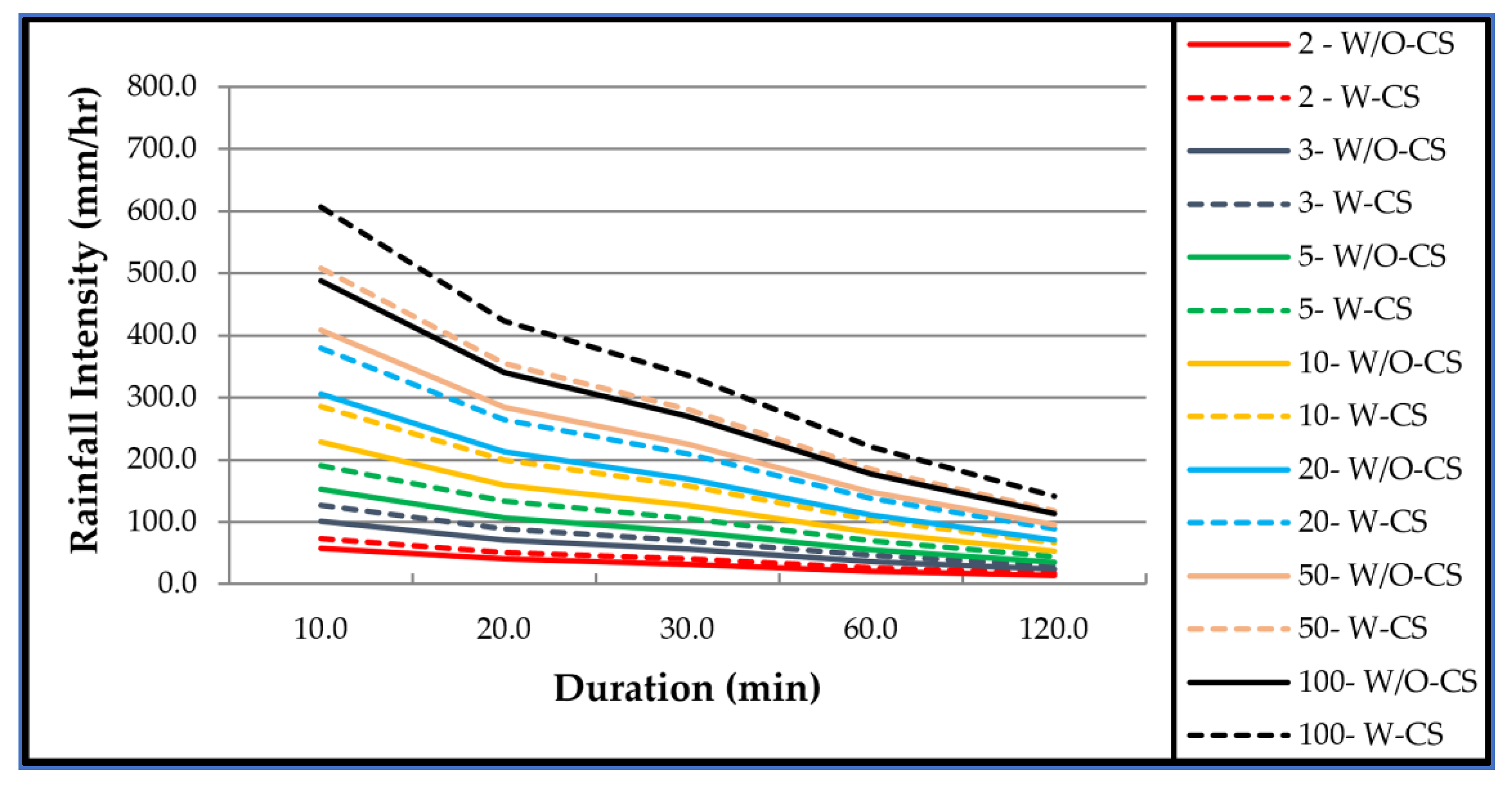
The IDF curves were developed as described in the methodology section. Table 6 and Table 7, respectively, present the generated IDF values for the three cities over periods (5, 10, 20, 30, 60 min, and 120 min) against different return periods (2, 3, 5, 10, 20, 50, and 100 years) representing both cases without cloud-seeding (W/O-CS) and with cloud-seeding (W-CS). The values in Table 7 clearly show the impact of cloud-seeding on intensity-duration-frequency curves where all values increased in the three cities. For example, in Sharjah city, the rainfall intensity over 10 min increased by 35.8% for a 2-year return period, 35.2%, and 34.8% for 10 and 100-years return periods.
Figure 2, Figure 3 and Figure 4 demonstrate the developed IDF curves for Sharjah, Al Dhaid, and Mleiha for both W/O-CS and W-CS cases over different return periods and illustrate the increase in rainfall intensity for all return periods W-CS. These figures clearly shows that the magnitude of the increase is a function of the return period, with more significant return periods exhibiting greater relative increases. The most significant increase in the values is found in the 100-year return period, and decreases gradually for smaller return periods.
The developed IDF functions for three different meteorological stations within the same geographical region of Sharjah (Sharjah airport, Al Dhaid, and Mleiha) before and after implementing cloud-seeding missions prove that cloud-seeding operations had led to an obvious increase in IDF values, i.e., the intensities of rainfall storms. In addition, the statistical analysis of the historical rainfall records confirmed that the mean of the maximum daily rainfall depths for each cloudseeded years had notably increased at the above meteorological stations compared to the pre-cloudseeding period.
Statistical analysis had provided a trustworthy indicator to make a judgment on the trend of historical rainfall records and can be used as a criterion to critic the impact of cloud-seeding on rainfall intensities. However, the comparison of the values of IDF curves before and after implanting the cloud-seeding missions had resolved the controversy related to the impacting of cloud-seeding on rainfall intensities by confirming that these missions had led to a clear and dramatic increase of rainfall storms intensity proved by the increase in the IDF curves values.
Another point to make is that cloud-seeding operations impact is not limited to the rainfall intensities but extends to create further implications on the local atmospheric aerosol burden. According to Farahat and Abuelgasim [25], the cloud-seeding missions conducted in the UAE between January 2017 to March 2017 had evaluated to determine particulate matter (PM) variability before and after implementing these missions. The investigations involve 20 ground-PM stations, which shows a significant increase in PM10 concentration during the above missioned period of cloud-seeding missions (Abuelgasim and Farahat) [26]. Therefore, it is important to further investigate this matter in the local and regional atmosphere as part of the comprehensive assessment of cloud-seeding operations.
5. Conclusions
Cloud-seeding should not be considered only for precipitation, but it should be considered within the comprehensive context of urban development plans where drainage impact assessment is considered as an essential element of the overall development of the city. In addition, despite the economic and environmental importance of cloud-seeding missions through enhancing water resources security by, for example, more surface water availability and improved groundwater recharge, its impact will require additional investment and/or enhancement to the city’s infrastructure. Therefore, it is strongly recommended to regularly update the IDF information, especially in regions similar to the UAE that adopt cloud-seeding missions and evaluate their impact on other aspects of the city, such as the efficiency and performance of the storm drainage networks.
Another significant output of the study is extended reliable historical rainfall records for Sharjah city based on the self-organizing map approach (developed separately in another paper under review). The synthesized, hindcast rainfall records effectively provided additional 21 years of hourly rainfall data for the three stations, improving the efficacy and reliability of future design studies in the region. This is because the uncertainty associated with hydrological designs reduces as the length of the data record increases (Bell, Adeloye) [24,27]. Given the high expense of obtaining such high-frequency data by traditional measurement instruments, these additional data are a low-cost valuable resource for Sharjah City and the wider UAE.
Author Contributions
Conceptualization, R.R. and K.B.A.; methodology, R.R. and K.B.A.; software, K.B.A.; validation, R.R.; formal analysis, K.B.A.; investigation, K.B.A.; resources, K.B.A.; data curation, K.B.A.; writing—original draft preparation, K.B.A.; writing—review and editing, R.R., G.W. and A.J.A.; visualization, R.R.; supervision, R.R., G.W. and A.J.A. All authors have read and agreed to the published version of the manuscript.
Funding
This research received no external funding.
Informed Consent Statement
Not applicable.
Data Availability Statement
Data could be requested from the first author.
Acknowledgments
We thank the National Center of Meteorology in the UAE for providing the historical meteorological records for the stations adopted in this study. We also want to show our gratitude to HE Abdullah Al Mandous (Director of the Center), Omer Al Yazidi (Director of Research, Development, and Training), Noura Al Hameli (Acting Head of Climate Section), and Taha Al Hosari (Senior Studies Researcher) for their time and effort spent in providing and discussing relevant study data. We extend our thanks to Eng. Anwaar Al Shimmari (Consul) for her continuous support in validating the row data obtained for this study.
Conflicts of Interest
The authors declare no conflict of interest.
References
- Yilmaz, A.G.; Shanableh, A.; Merabtene, T.; Atabay, S.; Kayemah, N. Rainfall Trends and Intensity-Frequency-Duration Relationships in Sharjah City, UAE. 17. Int. J. Hydrol. Sci. Technol. 2020, 10, 487–503. [Google Scholar] [CrossRef]
- Sherif, M.; Chowdhury, R.; Shetty, A. Rainfall and Intensity-Duration-Frequency (IDF) Curves in the United Arab Emirates. In World Environmental and Water Resources Congress 2014; American Society of Civil Engineers: Portland, Oregon, 2014; pp. 2316–2325. [Google Scholar] [CrossRef]
- Division of Environmental Sciences; Malik, S.; Bano, H.; Rather, R.A.; Ahmad, S. Cloud Seeding; Its Prospects and Concerns in the Modern World-A Review. Int. J. Pure App. Biosci. 2018, 6, 791–796. [Google Scholar] [CrossRef]
- Mazroui, A.A.; Farrah, S. The Uae Seeks Leading Position in Global Rain Enhancement Research. J. Weather Modif. 2017, 49, 54–55. [Google Scholar]
- Kumar, K.N.; Suzuki, K. Assessment of Seasonal Cloud Properties in the United Arab Emirates and Adjoining Regions from Geostationary Satellite Data. Remote Sens. Environ. 2019, 228, 90–104. [Google Scholar] [CrossRef]
- Ćurić, M.; Lompar, M.; Romanic, D.; Zou, L.; Liang, H. Three-Dimensional Modelling of Precipitation Enhancement by Cloud Seeding in Three Different Climate Zones. Atmosphere 2019, 10, 294. [Google Scholar] [CrossRef] [Green Version]
- UAE Conducts 95 Cloud Seeding Missions in First Three Months of 2020. Available online: https://www.thenationalnews.com/uae/environment/uae-conducts-95-cloud-seeding-missions-in-first-three-months-of-2020-1.1004847 (accessed on 24 July 2021).
- Al Hosari, T.; Al Mandous, A.; Wehbe, Y.; Shalaby, A.; Al Shamsi, N.; Al Naqbi, H.; Al Yazeedi, O.; Al Mazroui, A.; Farrah, S. The UAE Cloud Seeding Program: A Statistical and Physical Evaluation. Atmosphere 2021, 12, 1013. [Google Scholar] [CrossRef]
- Almazroui, M.; Islam, M.N.; Saeed, S.; Saeed, F.; Ismail, M. Future Changes in Climate over the Arabian Peninsula Based on CMIP6 Multimodel Simulations. Earth Syst. Environ. 2020, 4, 611–630. [Google Scholar] [CrossRef]
- Dar Consultant. Study for the Storm Water Accumulation and the Solutions for Proper Discharge; Study PD20074C-ENV-01 REV 0; Roads and Transport Authority, Dubai Municipality: Dubai, United Arab Emirates, 2020. [Google Scholar]
- Merabtene, T.; Siddique, M.; Shanableh, A. Assessment of Seasonal and Annual Rainfall Trends and Variability in Sharjah City, UAE. Adv. Meteorol. 2016, 2016, 1–13. [Google Scholar] [CrossRef] [Green Version]
- Adeloye, A.J.; Rustum, R. Lagos (Nigeria) Flooding and Influence of Urban Planning. Proc. Inst. Civ. Eng.-Urban Des. Plan. 2011, 164, 175–187. [Google Scholar] [CrossRef]
- Ewea, H.A.; Elfeki, A.M.; Al-Amri, N.S. Development of Intensity–Duration–Frequency Curves for the Kingdom of Saudi Arabia. Geomat. Nat. Hazards Risk 2016, 8, 570–584. [Google Scholar] [CrossRef] [Green Version]
- Elsebaie, I.H. Developing Rainfall Intensity–Duration–Frequency Relationship for Two Regions in Saudi Arabia. J. King Saud Univ.-Eng. Sci. 2012, 24, 131–140. [Google Scholar] [CrossRef] [Green Version]
- Aldosari, D.; Almedeij, J.; Alsumaiei, A.A. Update of Intensity-Duration-Frequency Curves for Kuwait Due to Extreme Flash Floods. Environ. Ecol. Stat. 2020, 27, 491–507. [Google Scholar] [CrossRef]
- Rustum, R.; Adeloye, A.; Simala, A. Kohonen Self-Organising Map (KSOM) Extracted Features for Enhancing MLP-ANN Prediction Models of BOD5. In Proceedings of the Quantification and Reduction of Predictive Uncertainty for Sustainable Water Resources Management, Perugia, Italy, July 2007; pp. 181–187. [Google Scholar]
- Adeloye, A.J.; Rustum, R. KSOM Clustering as a Possible Cure for the Wicked Water Problem of Inadequate Data for Water Resources Planning. In Hydrocomplexity: New Tools for Solving Wicked Water Problems; IAHS Press: Paris, France, 2010; pp. 35–36. [Google Scholar]
- Adeloye, A.J.; Rustum, R. Self-Organising Map Rainfall-Runoff Multivariate Modelling for Runoff Reconstruction in Inadequately Gauged Basins. Hydrol. Res. 2012, 43, 603–617. [Google Scholar] [CrossRef]
- Mwale, F.D.; Adeloye, A.J.; Rustum, R. Infilling of Missing Rainfall and Streamflow Data in the Shire River Basin, Malawi – A Self Organizing Map Approach. Phys. Chem. Earth Parts A/B/C 2012, 50–52, 34–43. [Google Scholar] [CrossRef]
- Mwale, F.D.; Adeloye, A.J.; Rustum, R. Application of Self-Organising Maps and Multi-Layer Perceptron-Artificial Neural Networks for Streamflow and Water Level Forecasting in Data-Poor Catchments: The Case of the Lower Shire Floodplain, Malawi. Hydrol. Res. 2014, 45, 838–854. [Google Scholar] [CrossRef]
- Panagoulia, D.; Mamassis, N.; Gkiokas, A. Deciphering the Floodplain Inundation Maps in Greece; European Water Resources Association: Porto, Potugal, 2013; pp. 323–330. [Google Scholar]
- Guide to Hydrological Practices, 6th ed.; World Meteorological Organization, Ed.; WMO: Geneva, Switzerland, 2009; Volume 2.
- Adlouni, S.E.; Bobée, B. Hydrological Frequency Analysis Using HYFRAN-PLUS Software. 2015. [Google Scholar]
- Bell, F.C. Generalized Rainfall-Duration-Frequency Relationships. J. Hydr. Div. 1969, 95, 311–328. [Google Scholar] [CrossRef]
- Farahat, A.; Abuelgasim, A. Effect of Cloud Seeding on Aerosol Properties and Particulate Matter Variability in the United Arab Emirates. Int. J. Environ. Sci. Technol. 2021. [Google Scholar] [CrossRef]
- Abuelgasim, A.; Farahat, A. Investigations on PM10, PM2.5, and Their Ratio over the Emirate of Abu Dhabi, United Arab Emirates. Earth Syst. Environ. 2020, 4, 763–775. [Google Scholar] [CrossRef]
- Adeloye, A.J. Streamflow Data and Surface Water Resource Assessment—A Quantitative Demonstration of Need for Ad-Equate Investment in Data Collection in Developing Countries. J. Water Supply Res. Technol. -Aqua 1990, 39, 228–336. [Google Scholar]
Figure 1.
Sharjah City Location Map showing the affected locations and Meteorological Stations.
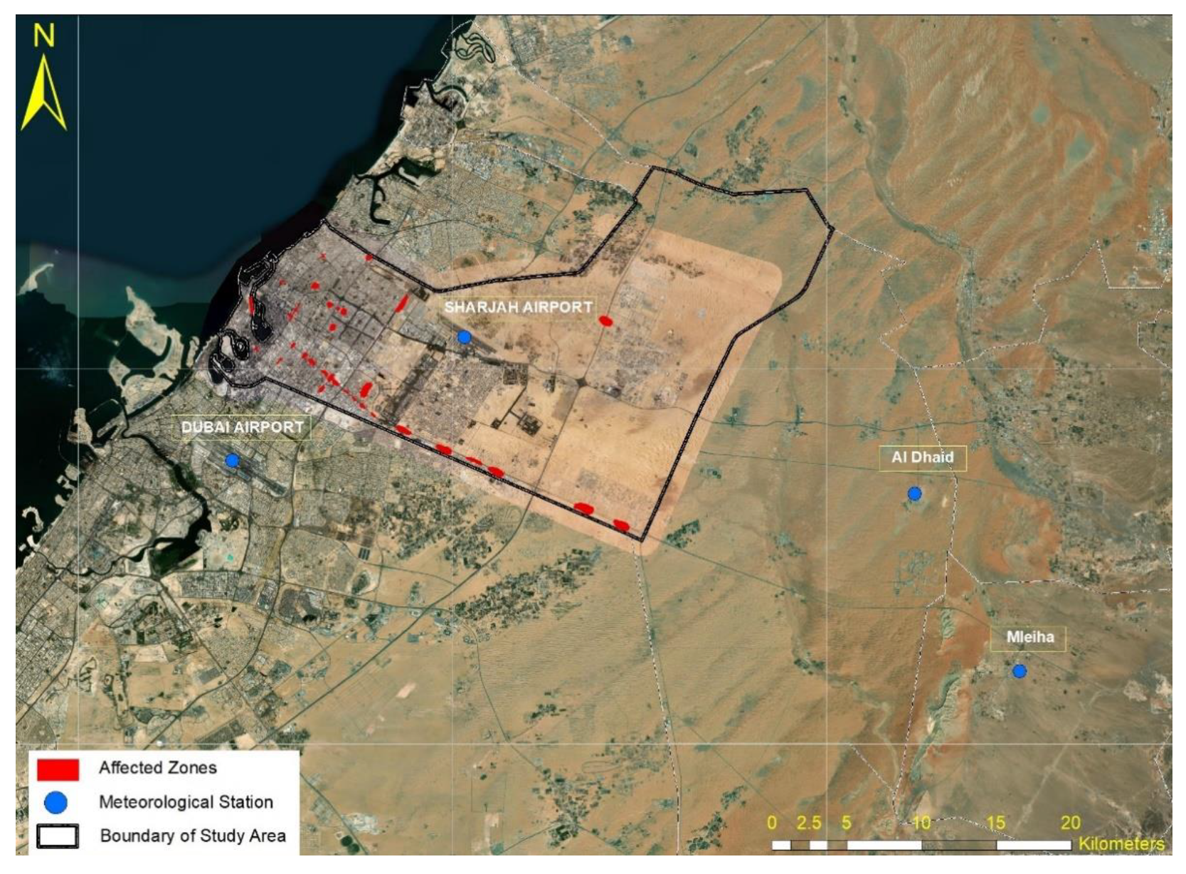
Figure 2.
IDF Curve for Sharjah City (W/O-CS) and (W-CS) for different return periods.
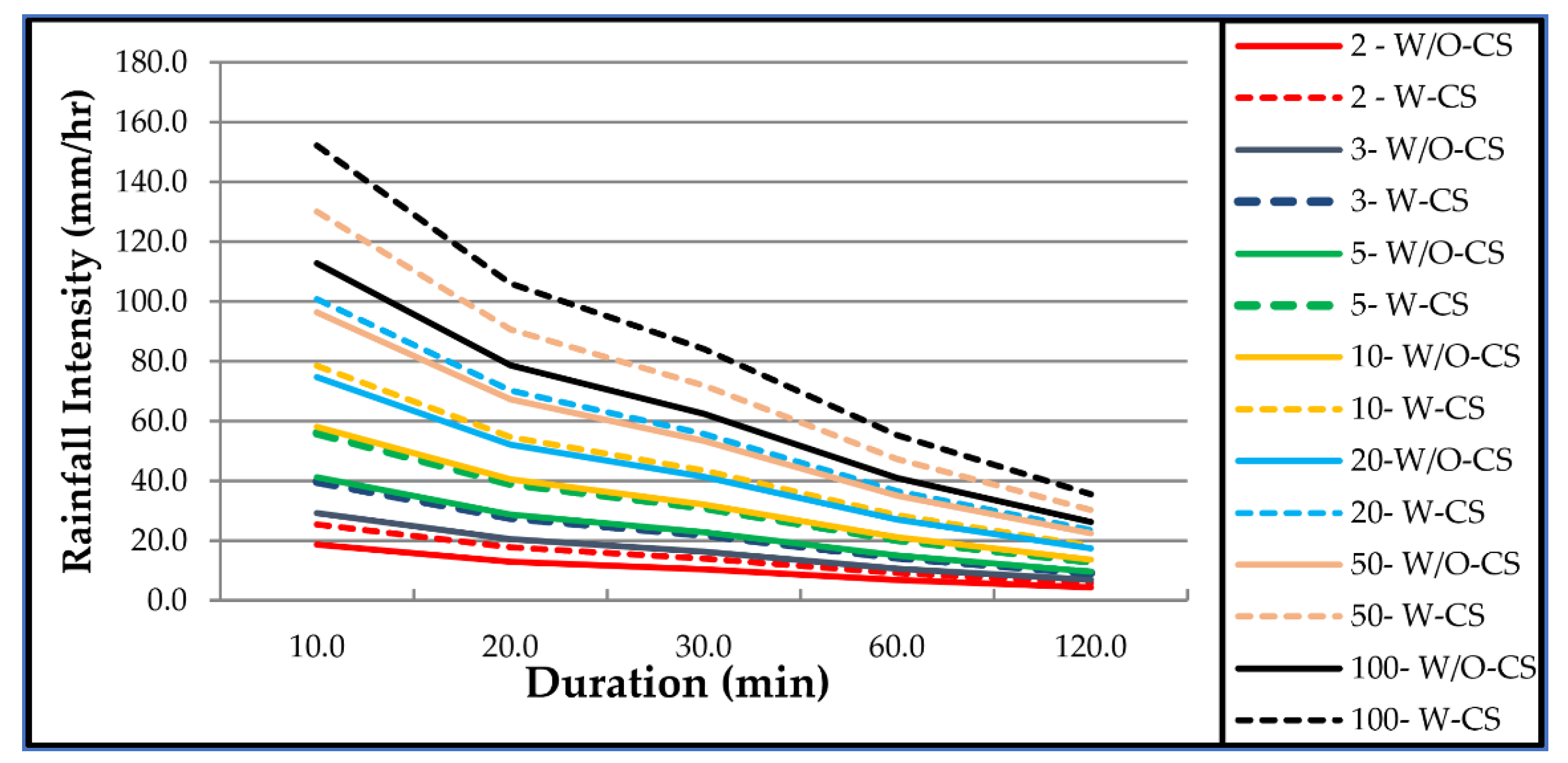
Figure 3.
IDF Curve for Al Dhaid City (W/O-CS) and (W-CS) for different return periods.
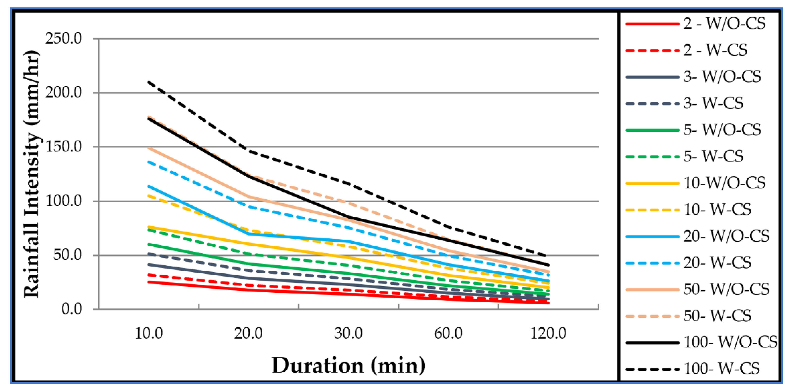
Figure 4.
IDF Curve for Mleiha City (W/O-CS) and (W-CS) for different return periods.

Table 1.
Meteorological station’s location coordinates adopted in the study and the dates of observed rainfall record.
Table 1.
Meteorological station’s location coordinates adopted in the study and the dates of observed rainfall record.
| Station Name | Altitude (m) | Coordinates | Dates/Duration | |
|---|---|---|---|---|
| Longitude | Latitude | |||
| Sharjah Airport | 34 | 55°31′02″ E | 25°19′43″ N | 16/09/2014–31/05/2020 |
| Al Dhaid | 111 | 55°49′01″ E | 25°14′13″ N | 01/03/2010–31/05/2020 |
| Mleiha | 186 | 55°53′17″ E | 25°07′50″ N | 01/01/2003–31/05/2020 |
| Dubai Airport | 19 | 55°21′52″ E | 25°15′10″ N | 01/01/1992–31/05/2020 |
Table 2.
Short duration ratios for Sharjah city.
| Duration (min) | 10 | 20 | 30 | 60 | 120 |
| Bell’s Ratios | 0.261 | 0.364 | 0.433 | 0.569 | 0.730 |
Table 3.
Maximum daily rainfall depth (mm) for three regions (W/O-CS).
| Year | Sharjah | Al Dhaid | Mleiha |
|---|---|---|---|
| 1992 | 11.4 | 8.3 | 5.1 |
| 1993 | 2.4 | 0 | 0 |
| 1994 | 2.4 | 15 | 61.3 |
| 1995 | 32.8 | 53.5 | 156.7 |
| 1996 | 16 | 26.6 | 121.1 |
| 1997 | 13 | 24.6 | 92.4 |
| 1998 | 14.3 | 24.3 | 43.5 |
| 1999 | 4.8 | 30.1 | 88.6 |
| 2000 | 10.1 | 26.8 | 71.7 |
| 2001 | 2.4 | 15.7 | 47.8 |
| 2002 | 5.9 | 14.2 | 44.3 |
| 2003 | 10.1 | 11 | 23.8 |
| 2004 | 7.6 | 5.8 | 9.8 |
| 2005 | 17.4 | 6.1 | 12.2 |
| 2006 | 7.4 | 37.3 | 18.2 |
| 2007 | 0.4 | 2.6 | 24 |
| 2008 | 61 | 41 | 50.4 |
| 2009 | 26.9 | 11.7 | 18.6 |
| Mean | 13.68 | 19.7 | 49.42 |
Table 4.
Maximum daily rainfall depth (mm) for three regions (W-CS).
| Year | Sharjah | Al Dhaid | Mleiha |
|---|---|---|---|
| 2010 | 24.3 | 36.8 | 22.2 |
| 2011 | 11.7 | 17 | 17.8 |
| 2012 | 5.5 | 30.2 | 62.6 |
| 2013 | 10.3 | 26.6 | 29.6 |
| 2014 | 6.5 | 14 | 34.8 |
| 2015 | 37.4 | 5.5 | 13.6 |
| 2016 | 13.5 | 140.8 | 461 |
| 2017 | 10.9 | 17.2 | 146.8 |
| 2018 | 78.2 | 7.2 | 25 |
| 2019 | 39.8 | 10.6 | 28.8 |
| 2020 | 53.9 | 41.2 | 64.3 |
| Mean | 26.55 | 31.55 | 82.41 |
Table 5.
Increment due to Cloud_seeding Missions.
| Sharjah | Al Dhaid | Mleiha | |
|---|---|---|---|
| Mean (W/O-CS) | 13.68 | 19.7 | 49.42 |
| Mean (W-CS) | 26.55 | 31.55 | 82.41 |
| Increment | 94.08% | 60.15% | 66.75% |
Table 6.
IDF (W/O-CS) for the three cities over different durations (mm/h).
| Return Period | City | IDF (W/O-CS) Over Different Durations (mm/h) | ||||
|---|---|---|---|---|---|---|
| 10 min | 20 min | 30 min | 60 min | 120 min | ||
| 2 | Sharjah | 18.64 | 13.00 | 10.31 | 6.77 | 4.35 |
| Al Dhaid | 25.31 | 17.65 | 14.00 | 9.19 | 5.90 | |
| Mleiha | 57.99 | 40.44 | 32.08 | 21.06 | 13.52 | |
| 3 | Sharjah | 29.28 | 20.42 | 16.20 | 10.63 | 6.82 |
| Al Dhaid | 41.37 | 28.85 | 22.88 | 15.02 | 9.64 | |
| Mleiha | 101.06 | 70.48 | 55.90 | 36.70 | 23.55 | |
| 5 | Sharjah | 41.18 | 28.72 | 22.78 | 14.95 | 9.60 |
| Al Dhaid | 60.07 | 41.89 | 33.23 | 21.81 | 14.00 | |
| Mleiha | 152.82 | 106.57 | 84.53 | 55.50 | 35.62 | |
| 10 | Sharjah | 57.99 | 40.44 | 32.08 | 21.06 | 13.52 |
| Al Dhaid | 76.06 | 60.46 | 47.96 | 31.49 | 20.21 | |
| Mleiha | 228.56 | 159.39 | 126.43 | 83.00 | 53.27 | |
| 20 | Sharjah | 74.61 | 52.03 | 41.27 | 27.10 | 17.39 |
| Al Dhaid | 113.53 | 69.45 | 62.80 | 41.23 | 26.46 | |
| Mleiha | 306.01 | 213.40 | 169.27 | 111.13 | 71.32 | |
| 50 | Sharjah | 96.34 | 67.18 | 53.29 | 34.99 | 22.45 |
| Al Dhaid | 149.04 | 103.94 | 82.44 | 54.12 | 34.74 | |
| Mleiha | 408.01 | 284.54 | 225.69 | 148.17 | 95.09 | |
| 100 | Sharjah | 112.77 | 78.64 | 62.38 | 40.95 | 26.28 |
| Al Dhaid | 175.86 | 122.64 | 85.33 | 63.87 | 40.99 | |
| Mleiha | 487.35 | 339.86 | 269.57 | 176.98 | 113.58 | |
Table 7.
IDF (W-CS) for the three cities over different durations (mm/h).
| Return Period | City | IDF (W-CS) Over Different Durations (mm/h) | ||||
|---|---|---|---|---|---|---|
| 10 min | 20 min | 30 min | 60 min | 120 min | ||
| 2 | Sharjah | 25.31 | 17.65 | 14.00 | 9.19 | 5.90 |
| Al Dhaid | 31.92 | 22.26 | 17.66 | 11.59 | 7.44 | |
| Mleiha | 73.10 | 50.98 | 40.44 | 26.55 | 17.04 | |
| 3 | Sharjah | 39.67 | 27.66 | 21.94 | 14.41 | 9.25 |
| Al Dhaid | 51.19 | 35.70 | 28.32 | 18.59 | 11.93 | |
| Mleiha | 127.13 | 88.65 | 70.32 | 46.17 | 29.63 | |
| 5 | Sharjah | 55.91 | 38.99 | 30.93 | 20.31 | 13.03 |
| Al Dhaid | 73.48 | 51.24 | 40.65 | 26.68 | 17.13 | |
| Mleiha | 190.78 | 133.05 | 105.53 | 69.28 | 44.46 | |
| 10 | Sharjah | 78.39 | 54.67 | 43.36 | 28.47 | 18.27 |
| Al Dhaid | 104.84 | 73.11 | 57.99 | 38.07 | 24.43 | |
| Mleiha | 285.23 | 198.91 | 157.77 | 103.58 | 66.48 | |
| 20 | Sharjah | 100.68 | 70.21 | 55.69 | 36.56 | 23.47 |
| Al Dhaid | 136.19 | 94.98 | 75.33 | 49.46 | 31.74 | |
| Mleiha | 379.68 | 264.78 | 210.02 | 137.88 | 88.49 | |
| 50 | Sharjah | 129.96 | 90.63 | 71.89 | 47.20 | 30.29 |
| Al Dhaid | 177.56 | 123.83 | 98.22 | 64.48 | 41.38 | |
| Mleiha | 508.13 | 354.35 | 281.07 | 184.53 | 118.43 | |
| 100 | Sharjah | 152.06 | 106.04 | 84.11 | 55.22 | 35.44 |
| Al Dhaid | 209.67 | 146.22 | 115.98 | 76.14 | 48.87 | |
| Mleiha | 606.35 | 422.85 | 335.40 | 220.20 | 141.32 | |
Publisher’s Note: MDPI stays neutral with regard to jurisdictional claims in published maps and institutional affiliations. |
© 2021 by the authors. Licensee MDPI, Basel, Switzerland. This article is an open access article distributed under the terms and conditions of the Creative Commons Attribution (CC BY) license (https://creativecommons.org/licenses/by/4.0/).
Share and Cite
MDPI and ACS Style
Almheiri, K.B.; Rustum, R.; Wright, G.; Adeloye, A.J. Study of Impact of Cloud-Seeding on Intensity-Duration-Frequency (IDF) Curves of Sharjah City, the United Arab Emirates. Water 2021, 13, 3363. https://doi.org/10.3390/w13233363
AMA Style
Almheiri KB, Rustum R, Wright G, Adeloye AJ. Study of Impact of Cloud-Seeding on Intensity-Duration-Frequency (IDF) Curves of Sharjah City, the United Arab Emirates. Water. 2021; 13(23):3363. https://doi.org/10.3390/w13233363
Chicago/Turabian StyleAlmheiri, Khalid B., Rabee Rustum, Grant Wright, and Adebayo J. Adeloye. 2021. "Study of Impact of Cloud-Seeding on Intensity-Duration-Frequency (IDF) Curves of Sharjah City, the United Arab Emirates" Water 13, no. 23: 3363. https://doi.org/10.3390/w13233363
Note that from the first issue of 2016, this journal uses article numbers instead of page numbers. See further details here.