1. Introduction
Riparian buffer zones, especially vegetated buffers, are viewed as the significant barrier between aquatic and terrestrial ecosystems to protect the freshwater environment and wildlife habitat. These areas have been demonstrated to stabilize the riparian microclimate, control soil erosion, retain sediment, nutrients, and pesticides from surface runoff and provide an ecological corridor to guard biodiversity [
1,
2,
3,
4,
5]. However, studies show that riparian buffers are threatened by anthropogenic construction activities as well as agricultural and urban landscapes due to inappropriate planning in many countries in the past decades [
6,
7,
8]. Therefore, the protection and restoration of the vegetated buffer zones (VBZ) are considered a low-impact and sustainable method for the government and land users to fulfill the service value of aquatic ecosystems [
9,
10].
Recent findings indicate that land use in different scales may influence water quality through changing the amount and flow path of contaminants from surface runoff or drainage network to the hydrologic systems [
11,
12]. Undoubtedly, accelerating urbanization brings positive changes to the economic development of suburban areas but replaces the original land cover with a more impervious surface [
13,
14]. However, restoration faces more challenges due to various obstacles such as land planning, sewage discharge, economic cost, and landscape demands. Thus, a buffer plan utilizing less space but with more interception capability has become a priority [
15,
16]. Moreover, the urban riparian landscape needs to become a green area with a high appreciation and enjoyment for lifestyle attraction.
Factors affecting the practice of buffer zones mainly focus on four aspects: the width, structure, species composition, and the vegetation management [
17]. Buffer width is one of the most critical and fundamental aspects during design [
18]. Typically, widths of 5–300 m are required to filter 10–95% sediments and nutrients [
19,
20,
21], and scholars offer advised width through investigations, experience, or mathematical models [
22,
23]. Complicated models like REMM (Riparian Ecosystem Management Model) [
24,
25], CREAMS (Chemical, Runoff and Erosion from Agricultural Management System Model) [
26], and VFSMOD (Vegetative Filter Strips Model) [
27] that are based on the whole physical process of sediment and pollutant deposition and migration can simulate the minimum width for specific removal efficiency of different riparian zones [
28]. Some multi-functional hydrological models like SWAT also integrate a buffer width module [
29]. Methods based on geographic Information Systems (GIS) and remote sensing techniques are also highlighted for the privilege in catchment scales and can delimit variable buffer zones for multiple needs [
30]. Xiang (1996) combined a math model derived from Phillips and GIS raster calculation model to identify boundary cells [
31,
32,
33]. Julio Novoa et al. (2018) used an RSQI index assessed by information extracted from high-resolution images to evaluate the ecological condition of buffer zones [
34]. Chun-hua Li et al. (2019) mapped the buffer zones of Zhushan Bay, Tai Lake through identifying critical source areas of non-point source pollution and ecologically sensitive areas based on GIS [
35]. Furthermore, current satellite-derived images with multiple spatial and temporal resolutions and better accuracy offer studies to fit different research scales from huge river catchment scales to small agricultural plots or urban areas.
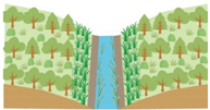
The structure of the vegetation composition strongly influences the capability of the buffer to reduce non-point sources (NPS) and create a natural environment. Typically, the structure is decided by distinct natural zones according to three-dimensional spatial structure, longitudinal, transverse, and vertical [
17]. However, in urban areas, artificial interferences such as hard revetment and flood control walls lead to the separation of river and land and loss of the structural characteristics, so detailed and natural-like zoning planning and plant community structure design is required [
36].
It is widely illustrated that aged woodland is the favored vegetation structure to maintain nutrient uptake, reinforce riverbanks, and stabilize underground flow for the dense underground root network formed by shallow and fibrous roots [
37]. Studies have shown that the nutrient absorption of woodland plants was significantly higher than that of herbaceous plants [
38]. However, the presence of vigorous herbaceous plants is indispensable, as the above-ground parts are very effective at retaining particulate matter and disperse concentrated flow during storms. Therefore, the structure with arbor, shrub and herb is recommended to create habitat diversity and sustain the ecological system [
39,
40]. Most management guidelines recommend it is better to select a natural riparian buffer as the reference standard and design the community structure regarding the native riparian forest to increase the species richness [
41]. Native species are precious when choosing species composition, and other functional plants chosen based on climate, soil characteristics, pollution interception ability, and decorative effect must be introduced properly to prevent invasion of alien species.
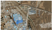
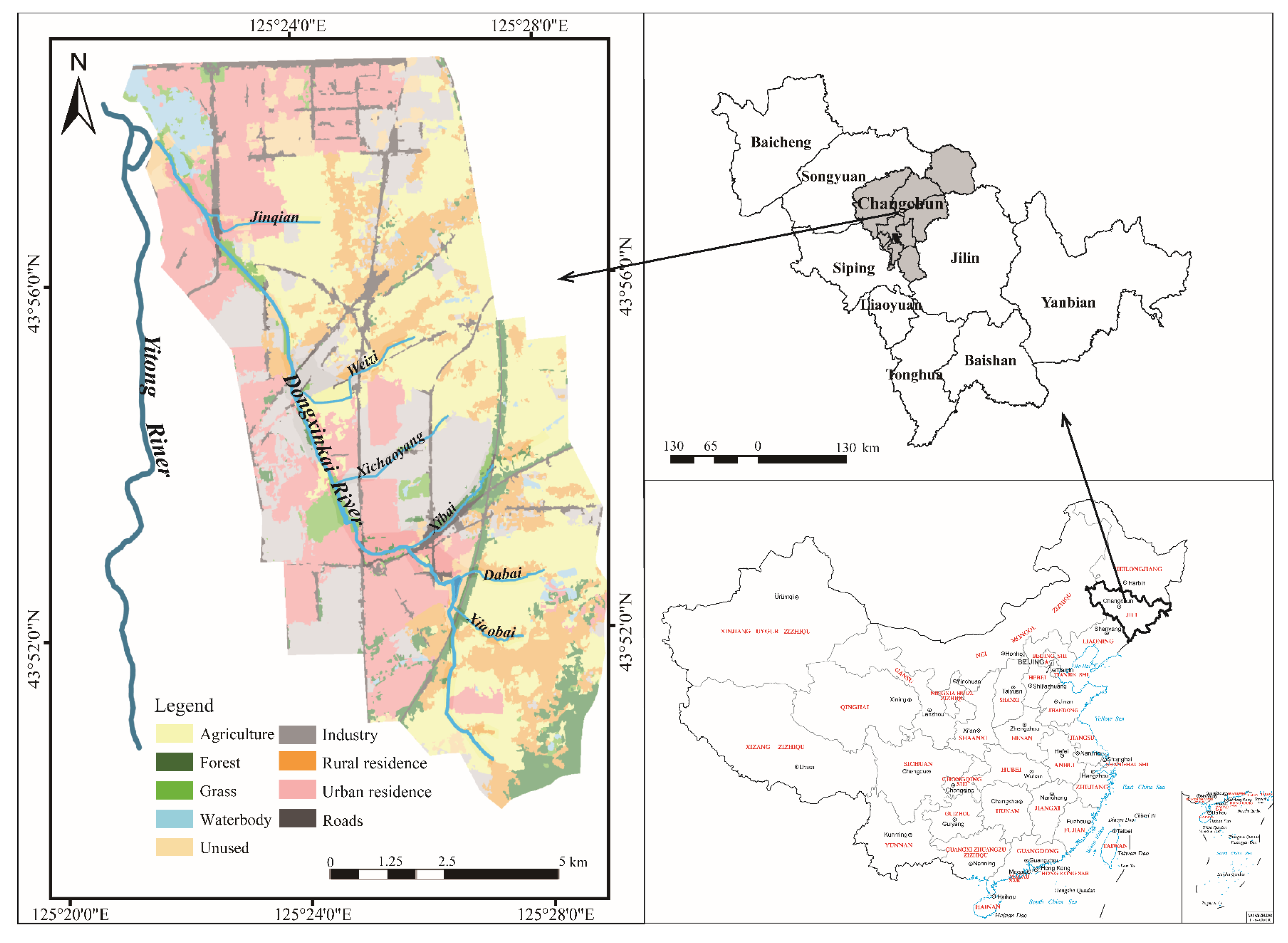
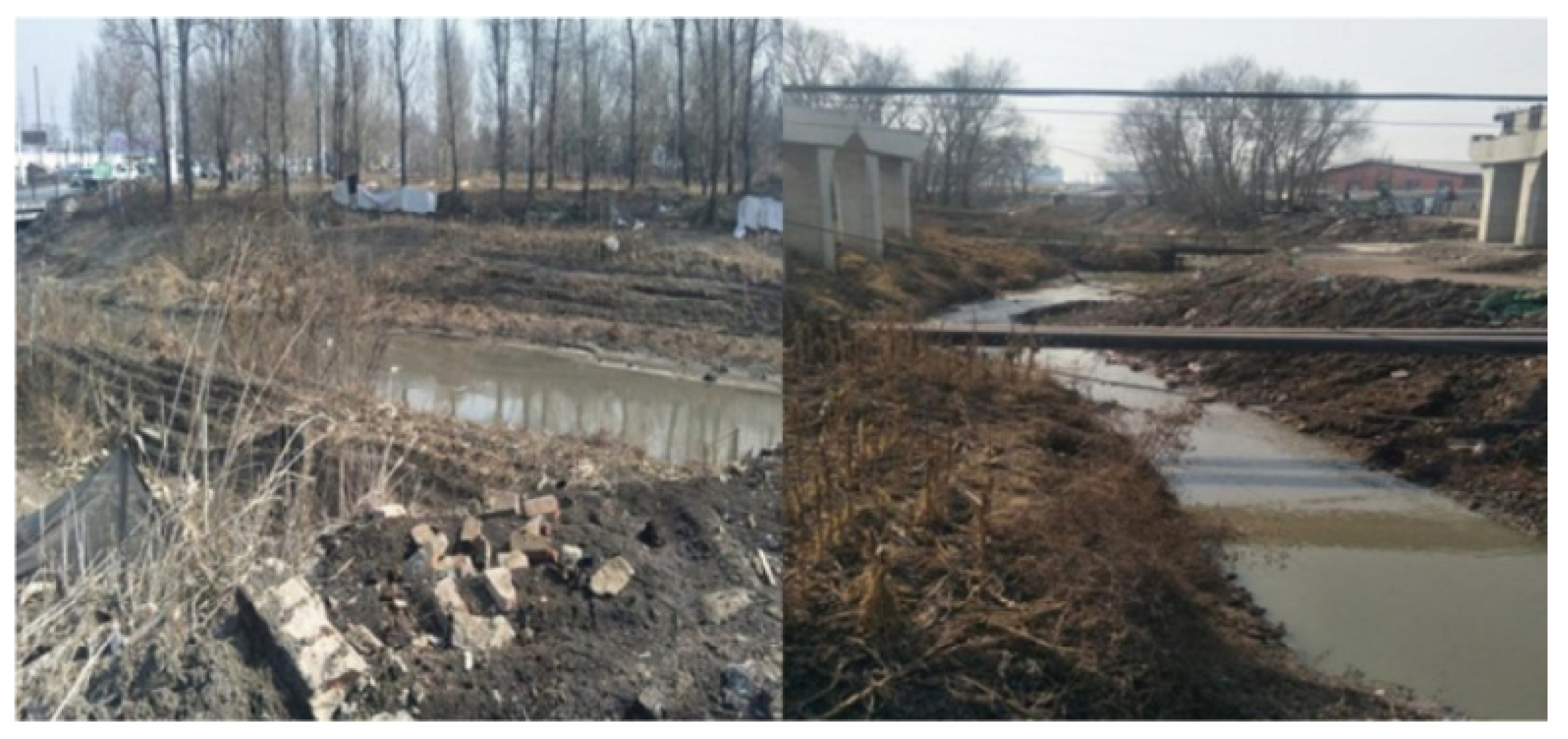
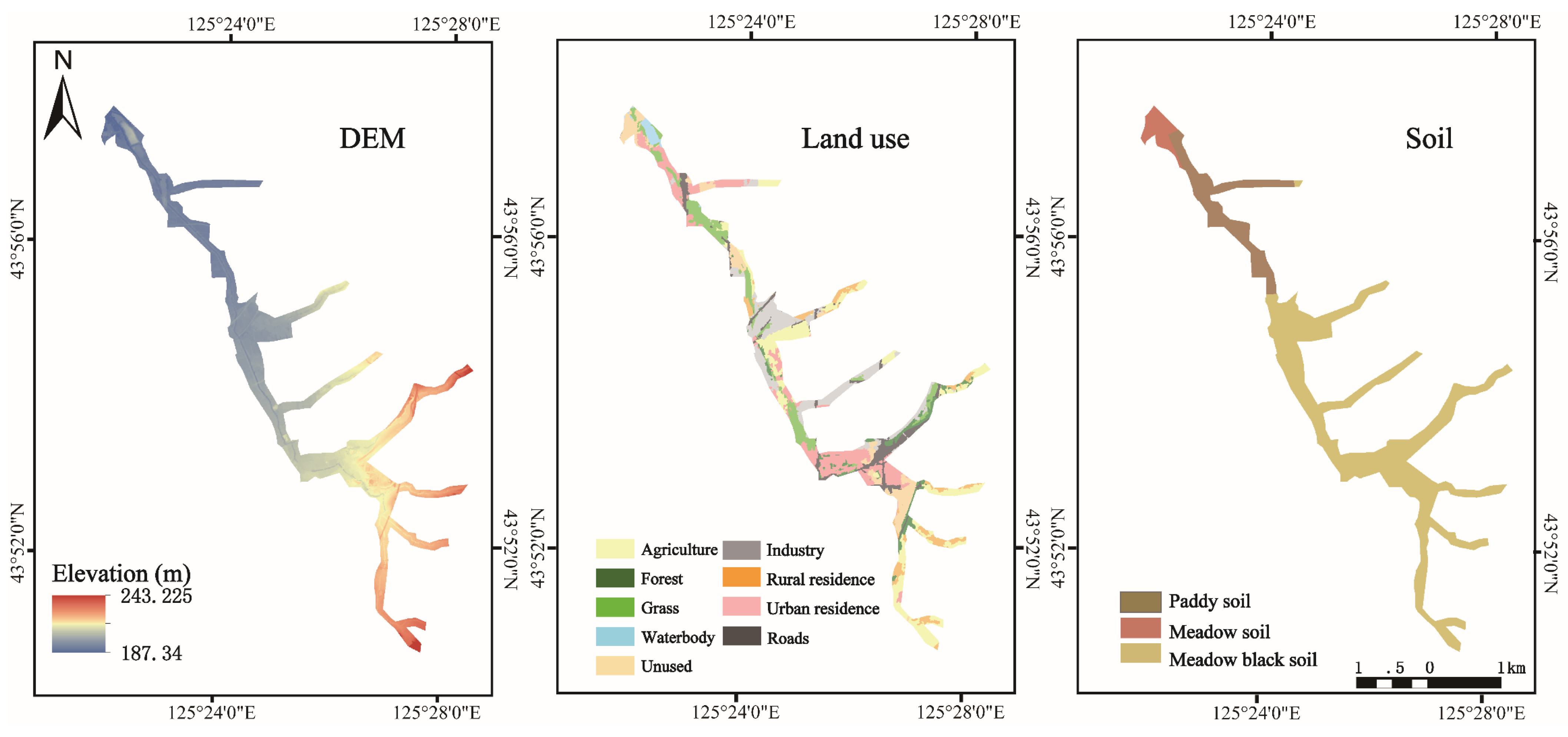
The Chinese government launched the Action Plan for Prevention and Control of Water Pollution in 2015, requesting that black and odorous water bodies in urban built-up areas be generally eliminated by 2030. The Dongxinkai (DX) River was heavily polluted, and the water quality was reduced to the worst class according to China’s surface water environmental quality standards, with average chemical oxygen demand (COD), total nitrogen (TN), and total phosphorus (TP) concentrations of 309.15, 63.73, and 3.17 mg/L in 2015. Therefore, the Changchun municipal government launched the comprehensive treatment plan of black and odorous water bodies and completed the construction of a sewage treatment plant and drainage pipe network. An appropriate design of riparian buffer strips is crucial for the successful restoration of river ecology.
Overall, the purpose of this study is to develop a general idea of ecological restoration planning of heavily polluted urban rivers. For this purpose, after a detailed field investigation, we conducted experiments to choose appropriate plant arrangements and built a reference buffer to obtain the required parameters. Afterward, the VBZ width suitable for VBZ restoration and urban planning was delimited based on GIS. Finally, these conclusions and methods were applied to the planning of the Dongxinkai River buffer zone. This research may help the government manage the VBZ better to provide sustainable protection for river ecosystems.
4. Discussion
The design of river buffer zone in urban built-up areas is different from that in large river basins, which needs to be more detailed and scientific. Plant selection and allocation, reasonable buffer width, and sustainable management are equally important. Plant selection is the basis of green coverage, and priority should be given to local species; alien species for promoting ornamental effect must be tested before large-scale planting. Moreover, the number and proportion of different plants, planting position, and density are acquired to be designed scientifically in advance to plant the available species together and form a sustainable ecosystem. Configuration of arbor, shrub, and herbage varies due to different construction purposes; the arbor has some advantages in stabilizing riverbanks, protecting groundwater, and resisting flood; the grassland is well-suited to filtering nutrients and insecticides, and improving animal habitat.
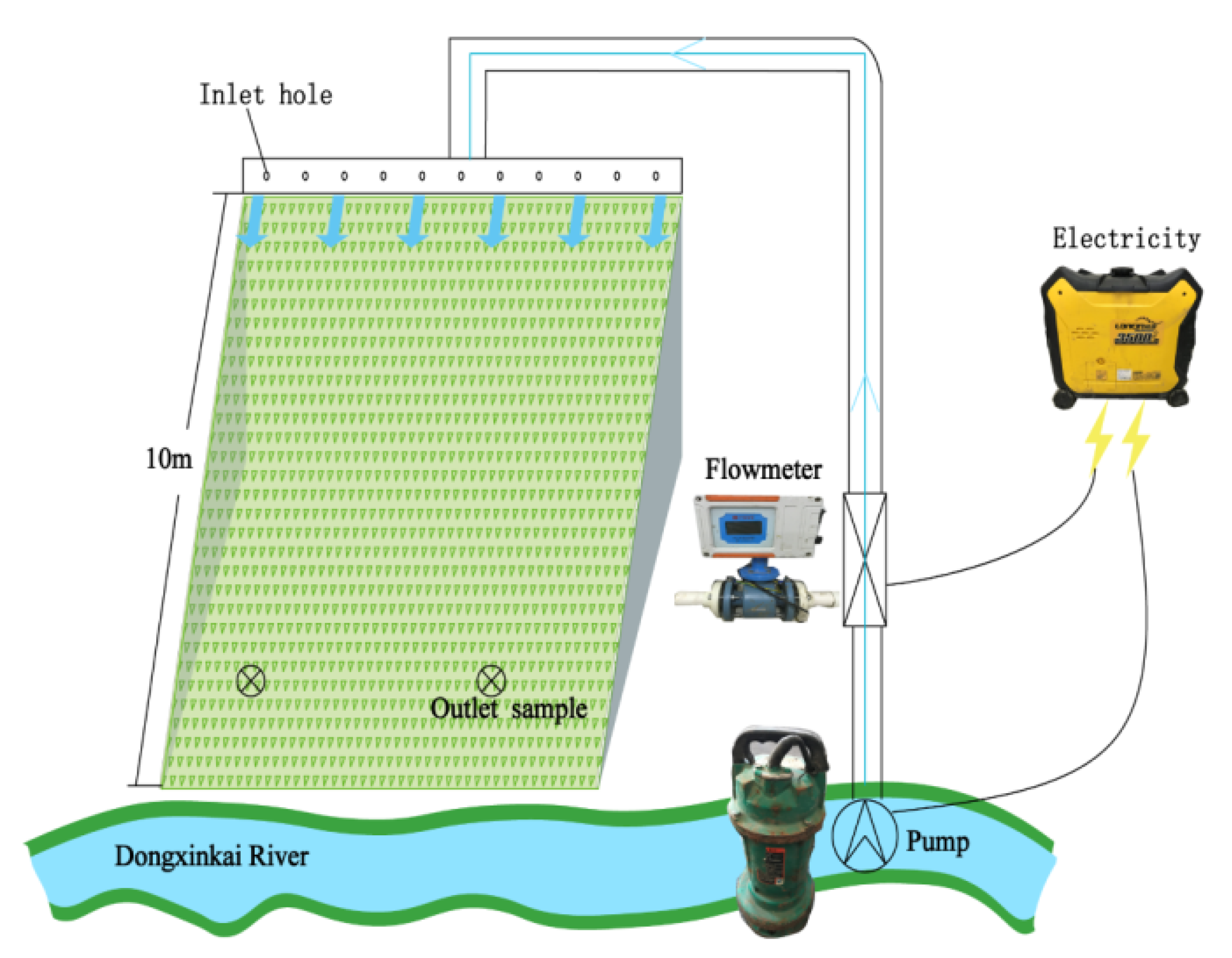
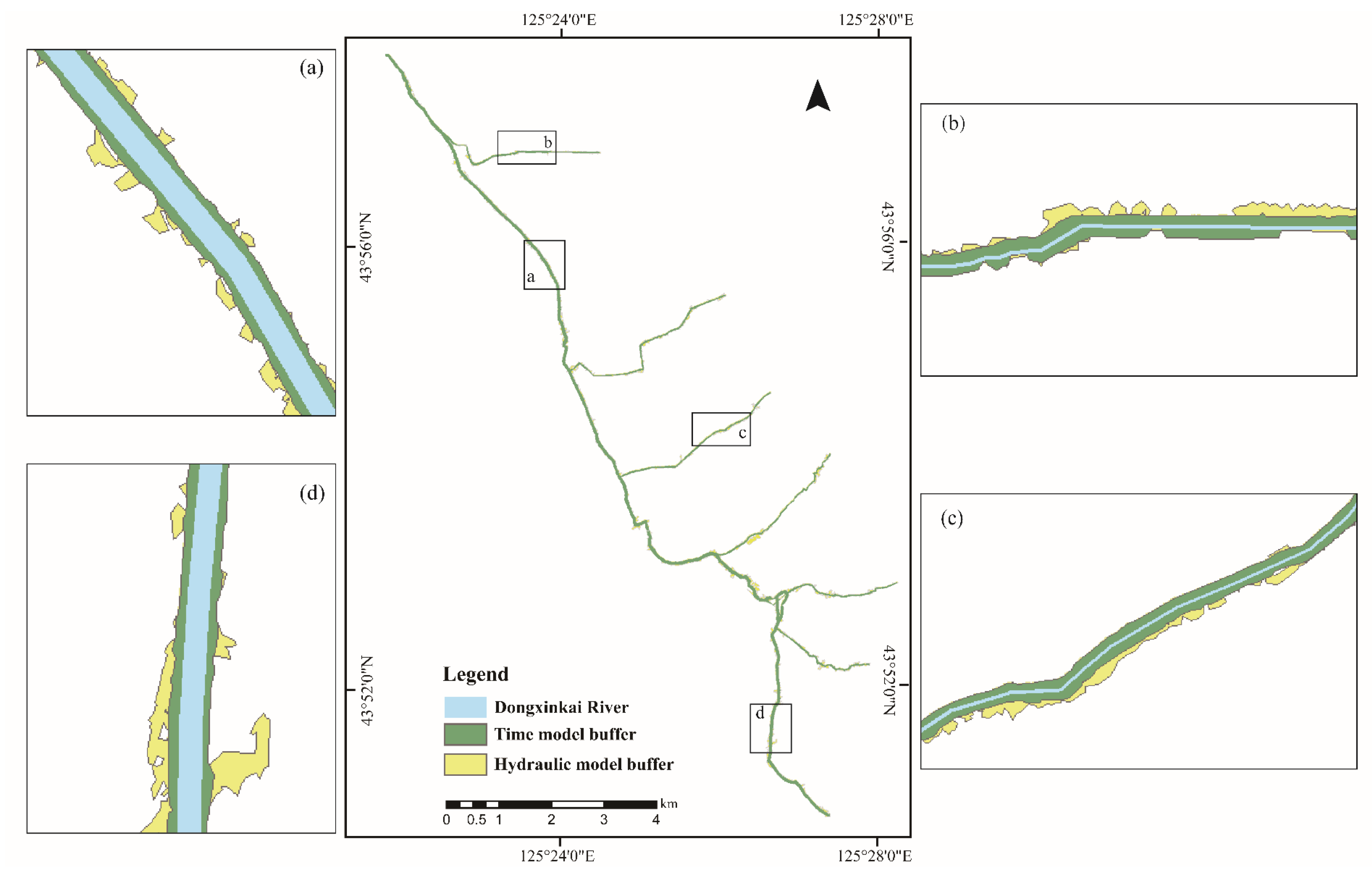
Buffer zone boundary delimitation is the main idea to preserving the ecological space for river ecosystems. Delineation methods based on GIS technology are feasible and reliable which can produce meticulous results through spatial calculation affected by topography, soil, and surrounding conditions. The accuracy of the boundary mapping highly depends on the spatial resolution of the acquired land cover and slope data, so it is essential to choose a suitable accuracy level to fulfill the basin size, planning purpose, and project budget. For elevation data set, LiDAR technology and airborne LiDAR system are gradually common in topographic information collection and positioning repeated observation, which can quickly acquire large area 3D terrain data and produce digital products [
53]. Research in ecology has laid more emphasis on the unmanned aerial vehicle (UAV) technology through the whole process of design, construction, and supervision in recent years because of its advantages in vegetation survey, routine monitoring, and emergency investigation [
54]. In this research, we applied the technologies appropriately to reach the scale and accuracy we require without bearing a great economic burden. Undoubtedly, the extensive application of these technologies creates new vitality for some classical and precise models.
In the future, almost all population growth will concentrate in urban areas and bring more pressure on urban drainage and river landscape design, especially in developing countries. Most countries started the history of river protection from the treatment of water pollution, then to the reconstruction of small river habitats, and finally to the restoration of the whole river ecology due to the lack of long-term land use planning, and the urban ecosystem was destroyed repeatedly. In order to protect the economic development and reserve a specific living space for the aquatic ecosystem, it is necessary to draw a reasonable control boundary for the river in advance, prohibit destructive human activities within the boundary, and carry out vegetation restoration to conserve water resources and protect the habitats of animals and plants. Urban rivers can never be regarded as a part of the linear drainage pipeline, but a strip-shaped reserved land, which should first be circled in the urban land use planning and guaranteed by the land use policy. Furthermore, the focus of aquatic ecological restoration should gradually turn to the protection of aquatic plants and their habitats by optimizing the water quality evaluation system and implementing a typical water ecological function zone pilot. It is commonly recognized that beautiful urban water spaces and landscapes are more and more critical while disposing the city resources to promote the city vitality and competition capability. This study was developed in Changchun to provide a recommendation process for the local government to build scientific buffer zones, and ensure that the environmental protection, ecological value, and operating costs are effectively taken into account in the restoration and maintenance of riparian zones. Its design ideas could be used for references and applied to other urban watersheds in cities and suburbs.
5. Conclusions
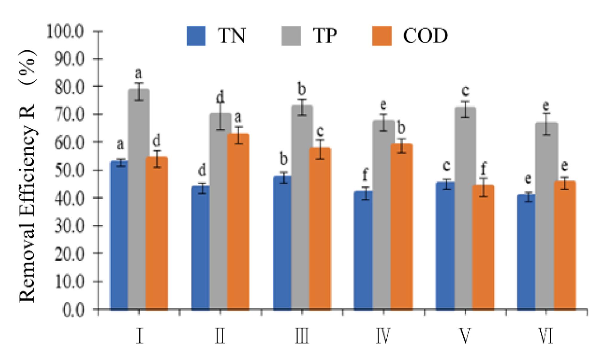
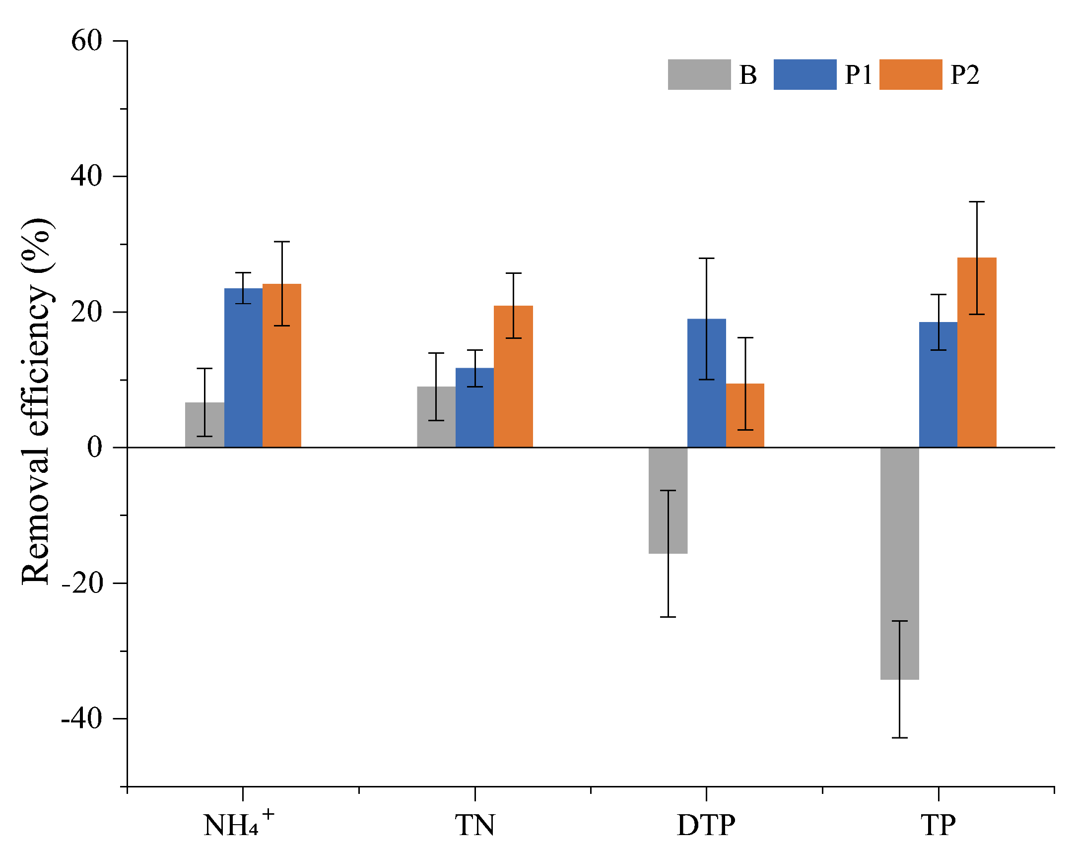
This research proposed general ideas and technologies for the planning of riparian buffer zone restoration in heavily polluted urban watersheds and applied the whole process in the DX River, Changchun, China. It forms a complete integrated buffer planning and design process, including width delimitation, vegetation screening, zoning design, and field verification. In the study area, the 40–60 m VBZ can intercept 2025% of nutrients from the storm runoff. The order of nutrient interception capacity of VBZ was NH4+-N > TN > TP. By optimizing vegetation structure, the width of the buffer zone can be reduced to around 40 m and 20 m, which saves 17% of the available land for future economic development. According to the characteristics of different river sections in the basin, three configurations of the arbor, shrubbery, and grass in the buffer zone were designed with an emphasis on pollution interception, landscape, and cost, separately. In addition, this study puts forward the design principle of the buffer zone in the small urban watershed, which can alleviate the contradiction between urban land shortage and river ecological protection, and provide suggestions and references for other similar research areas.


