
Small Catchment Runoff Sensitivity to Station Density and Spatial Interpolation: Hydrological Modeling of Heavy Rainfall Using a Dense Rain Gauge Network

 , ,
, ,
Abstract
1. Introduction
2. Study Area and Data
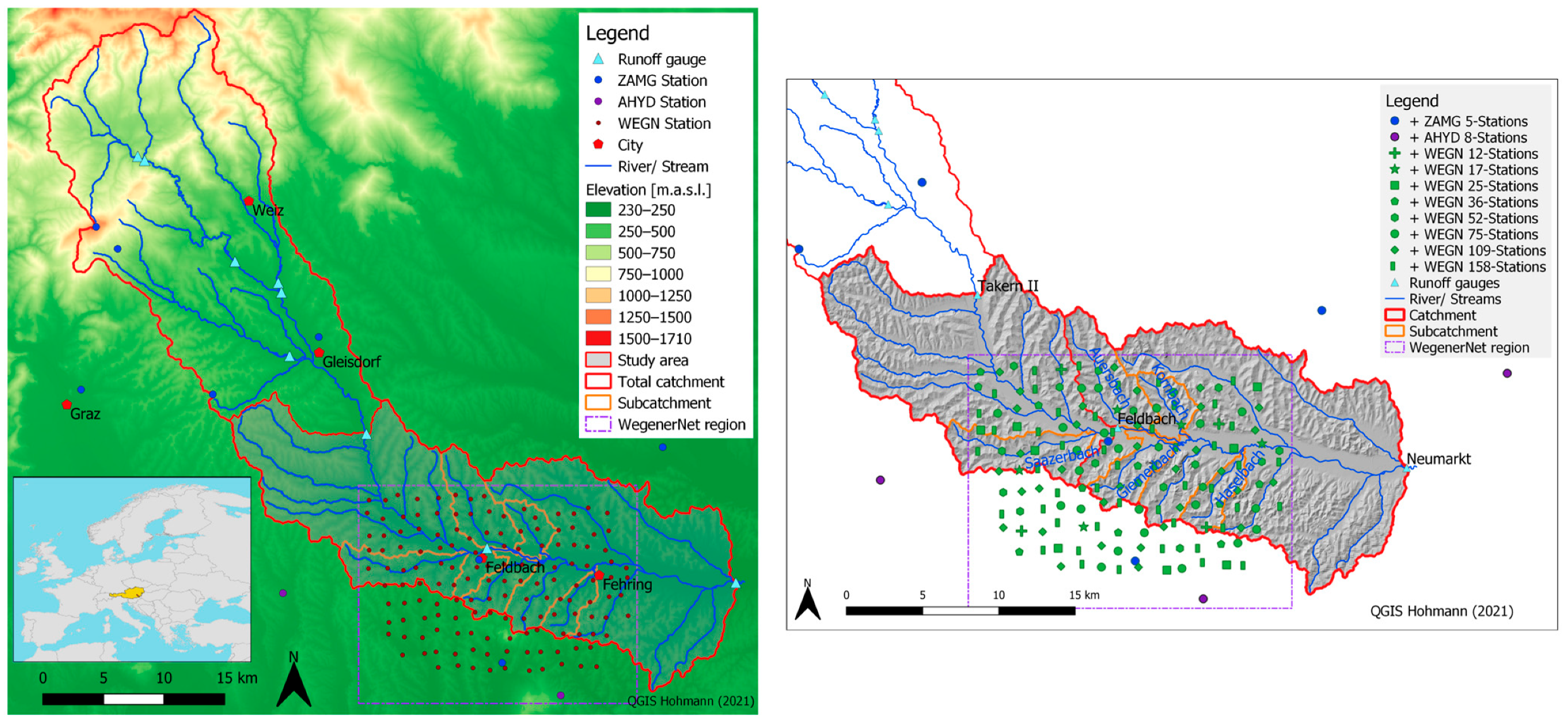
2.1. Study Area
2.2. Data
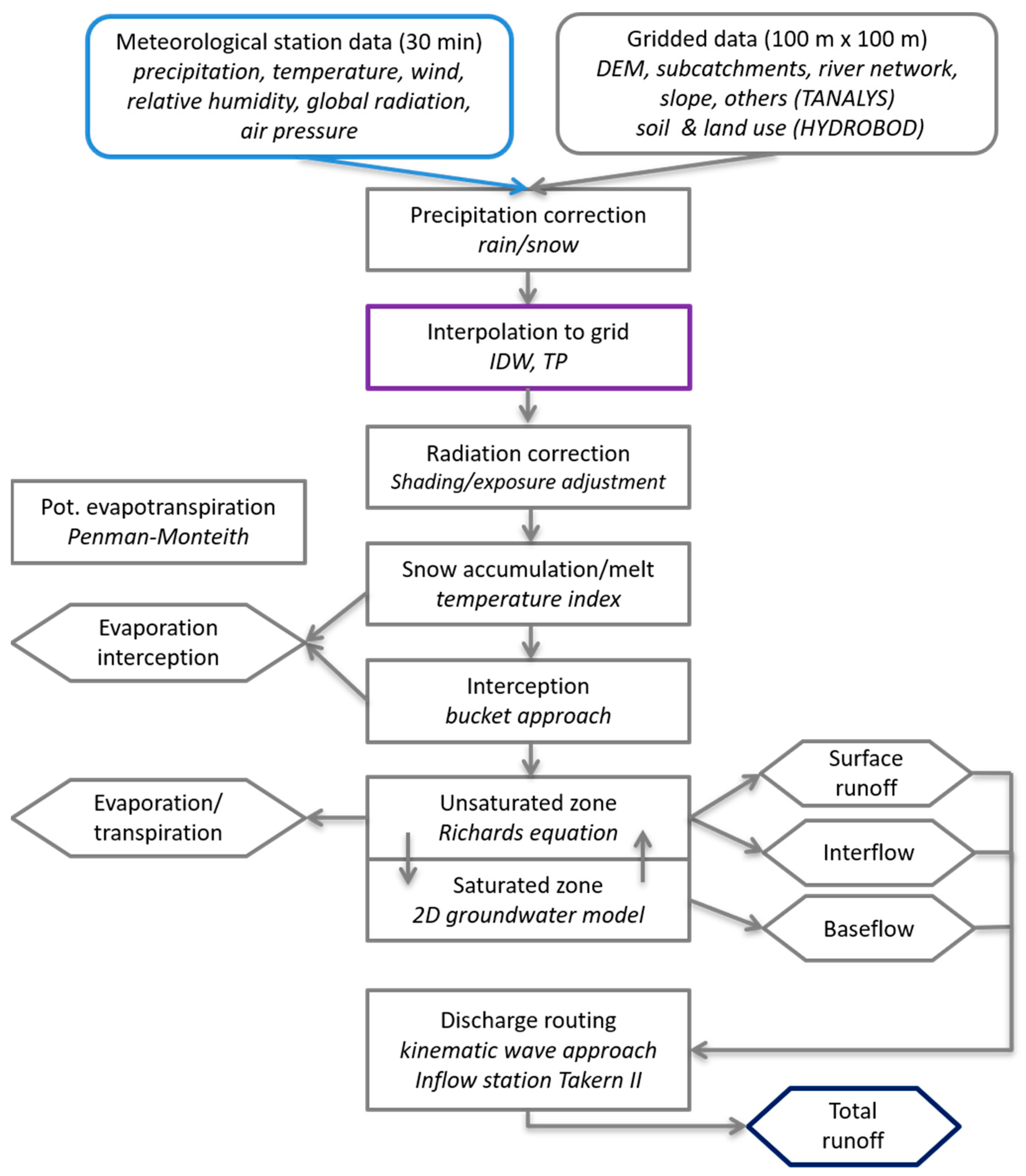
3. Modeling Approach
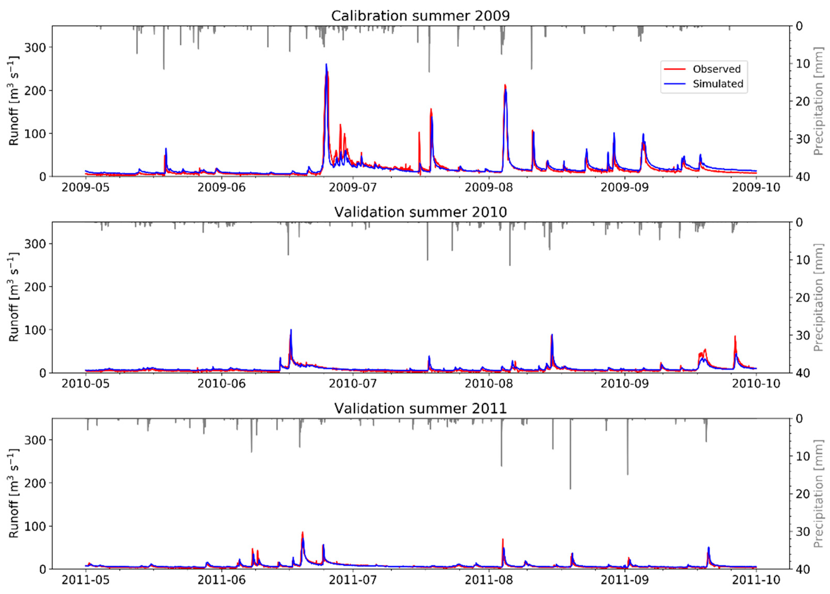
3.1. Model Setup and Calibration
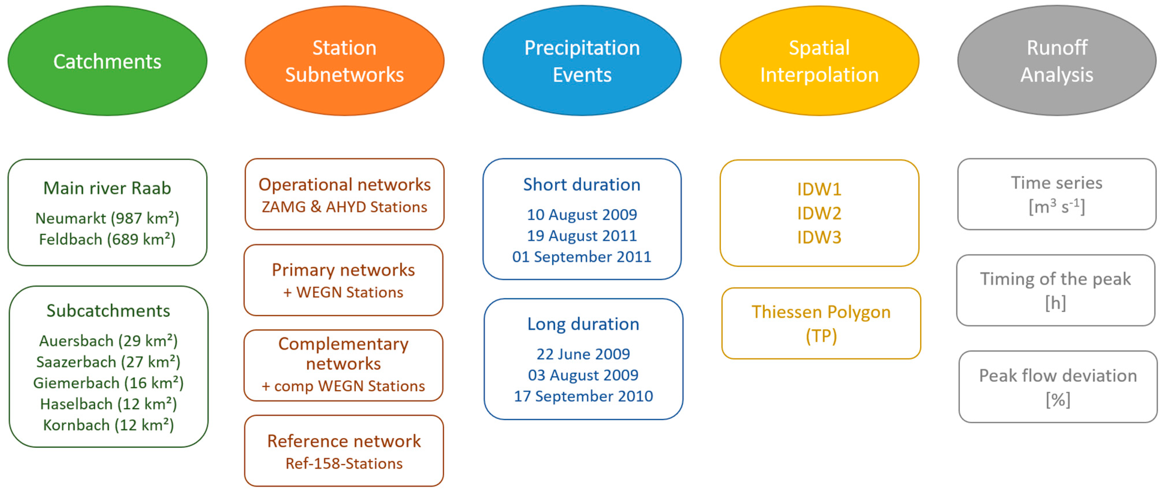
3.2. Experimental Design
3.2.1. Selection of Precipitation Station Network Densities
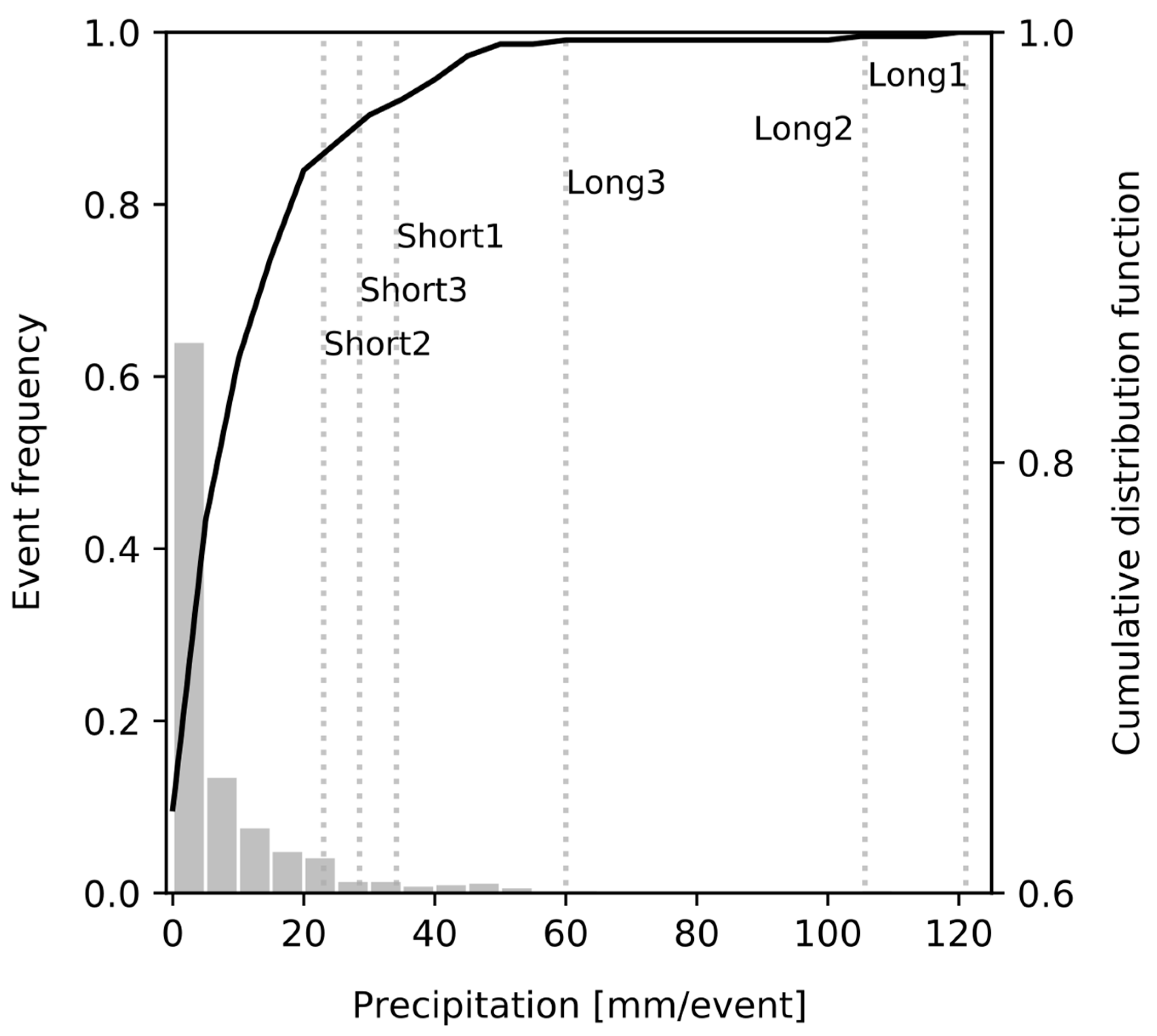
3.2.2. Selection of Precipitation Events
3.2.3. Spatial Interpolation Schemes
3.2.4. Runoff Analysis Approach
4. Results
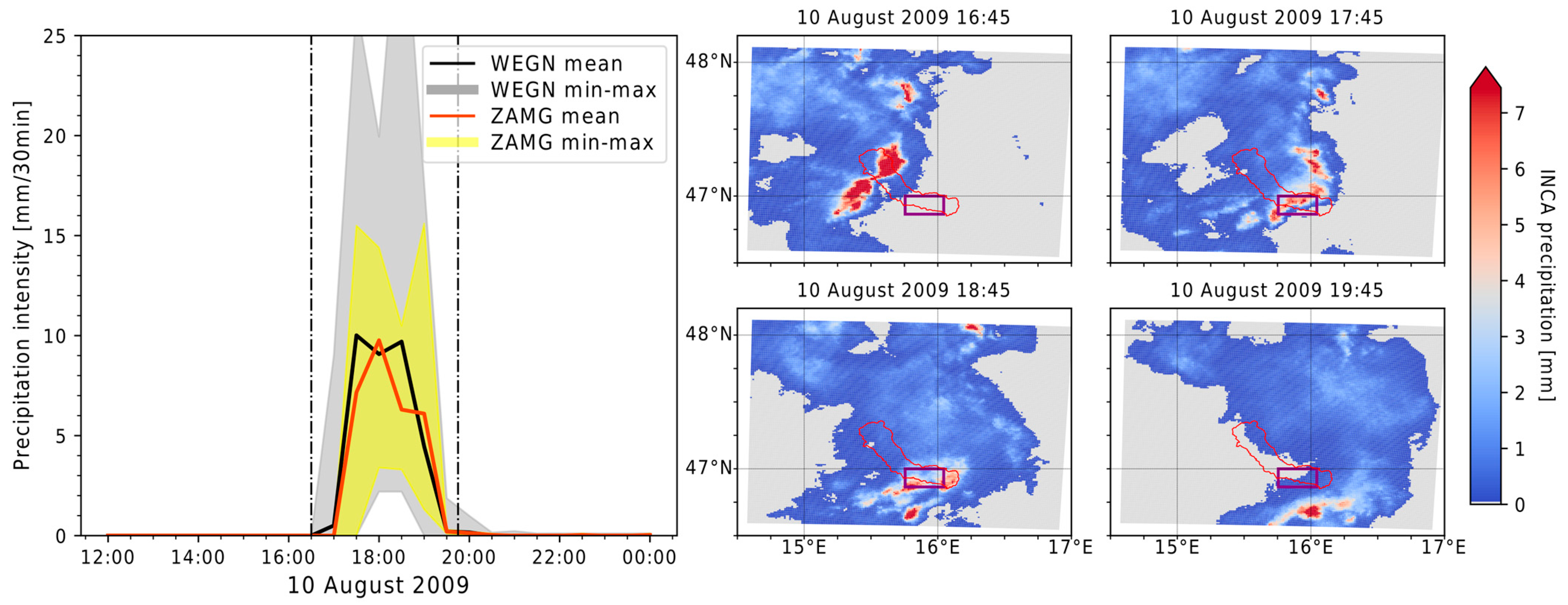
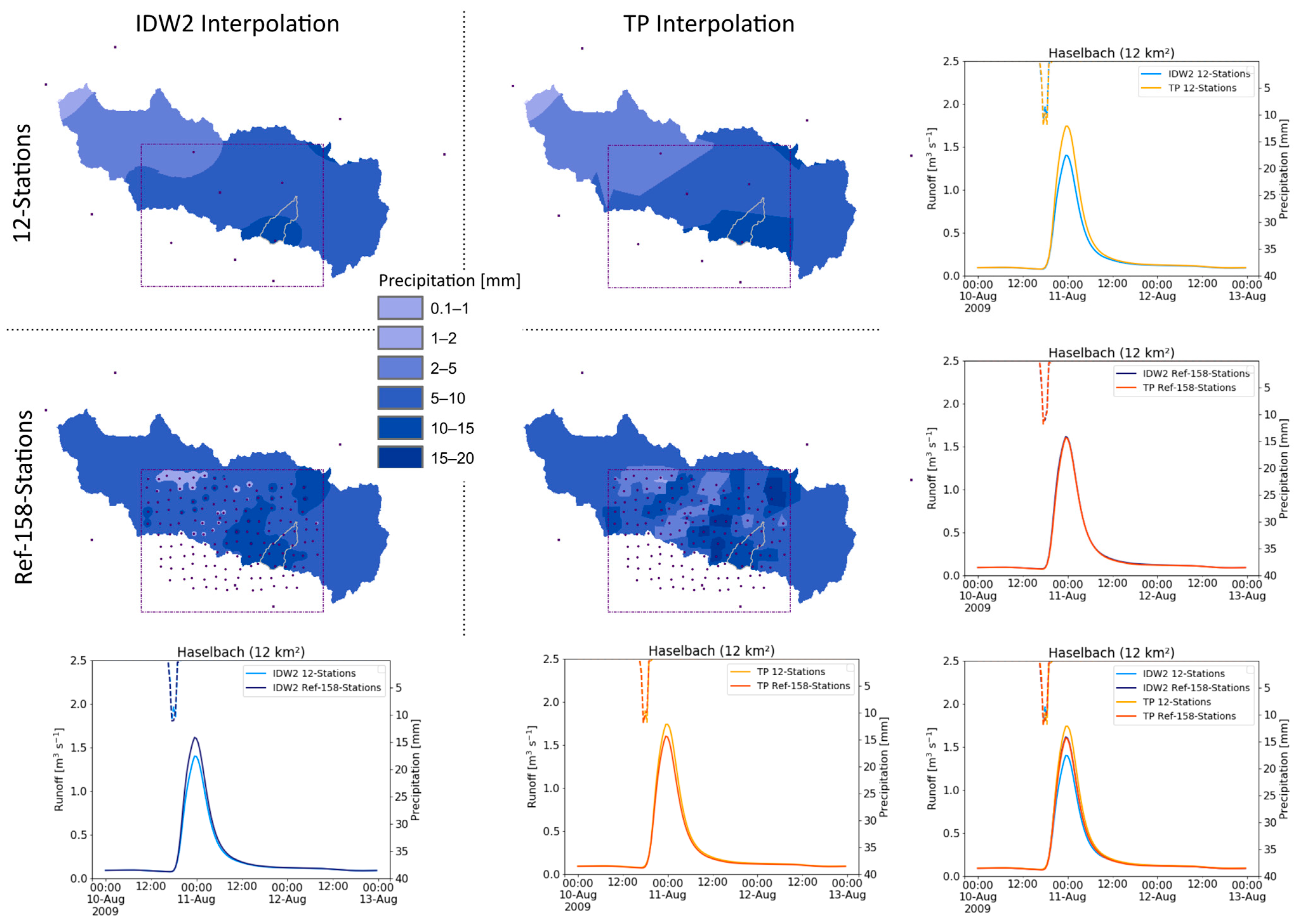
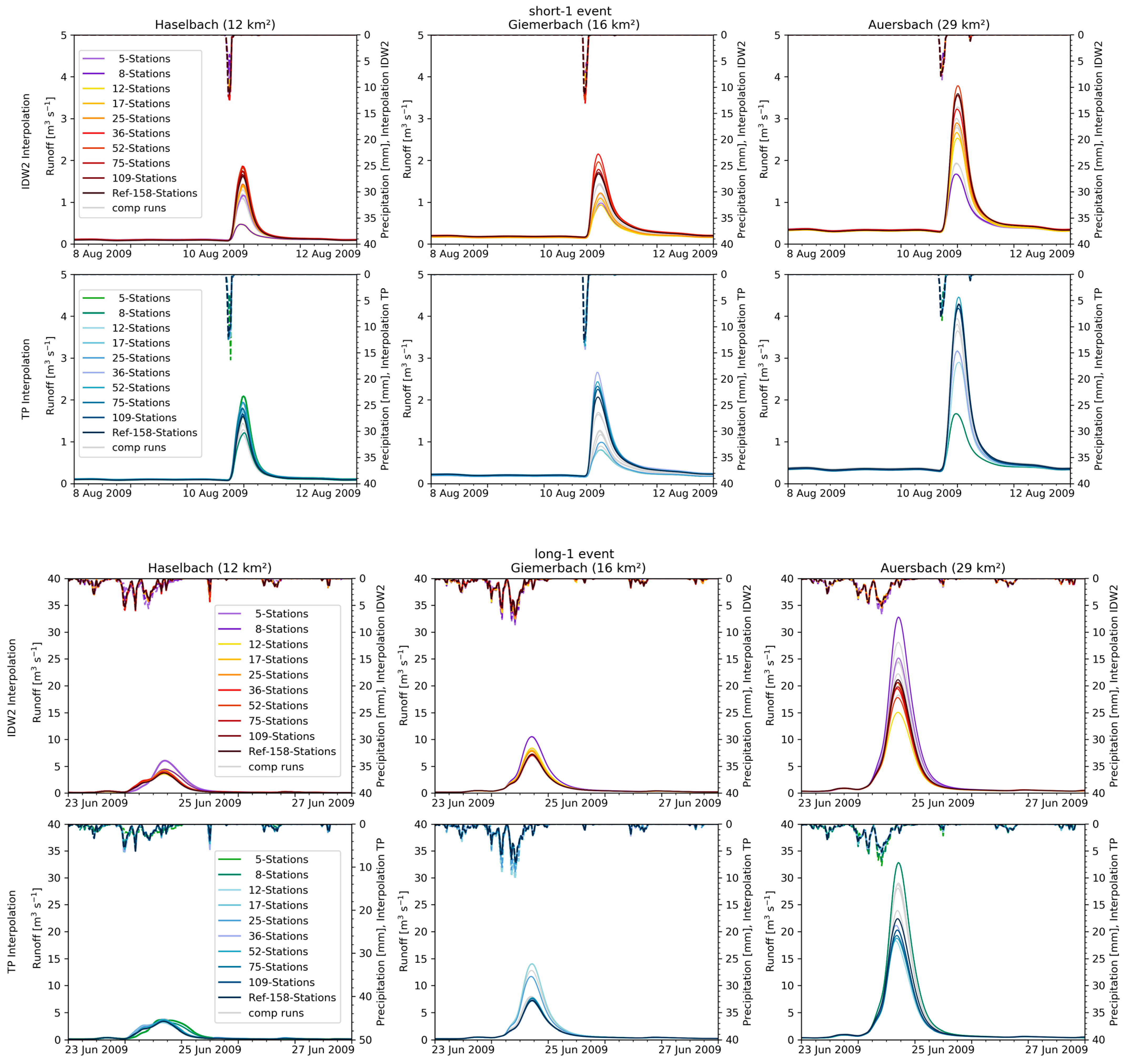
4.1. Results for Individual Example Events
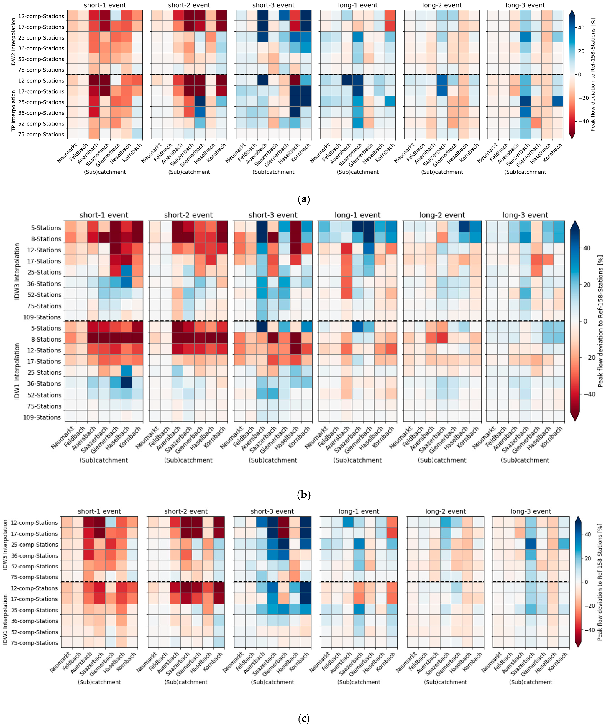
4.2. Combined Results for All Events
4.2.1. Timing of Peak Flow
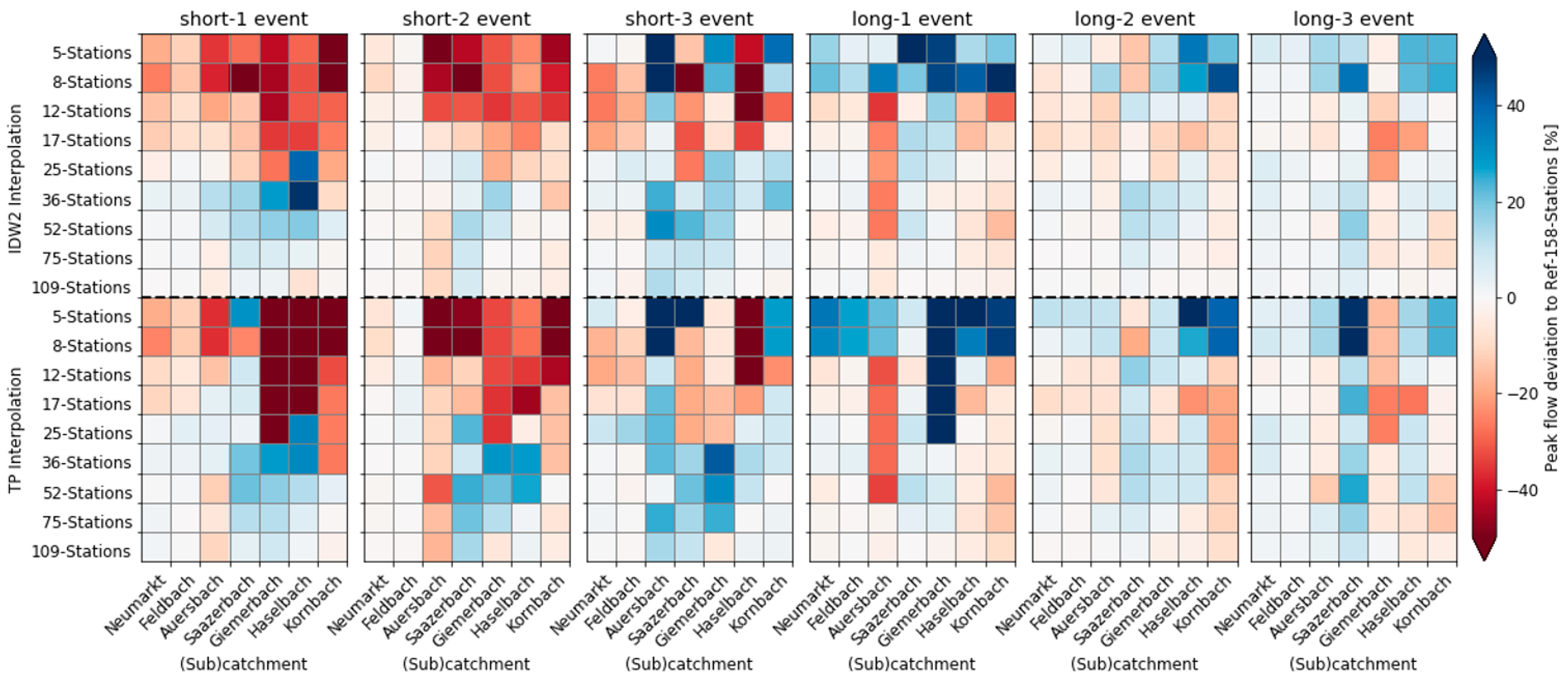
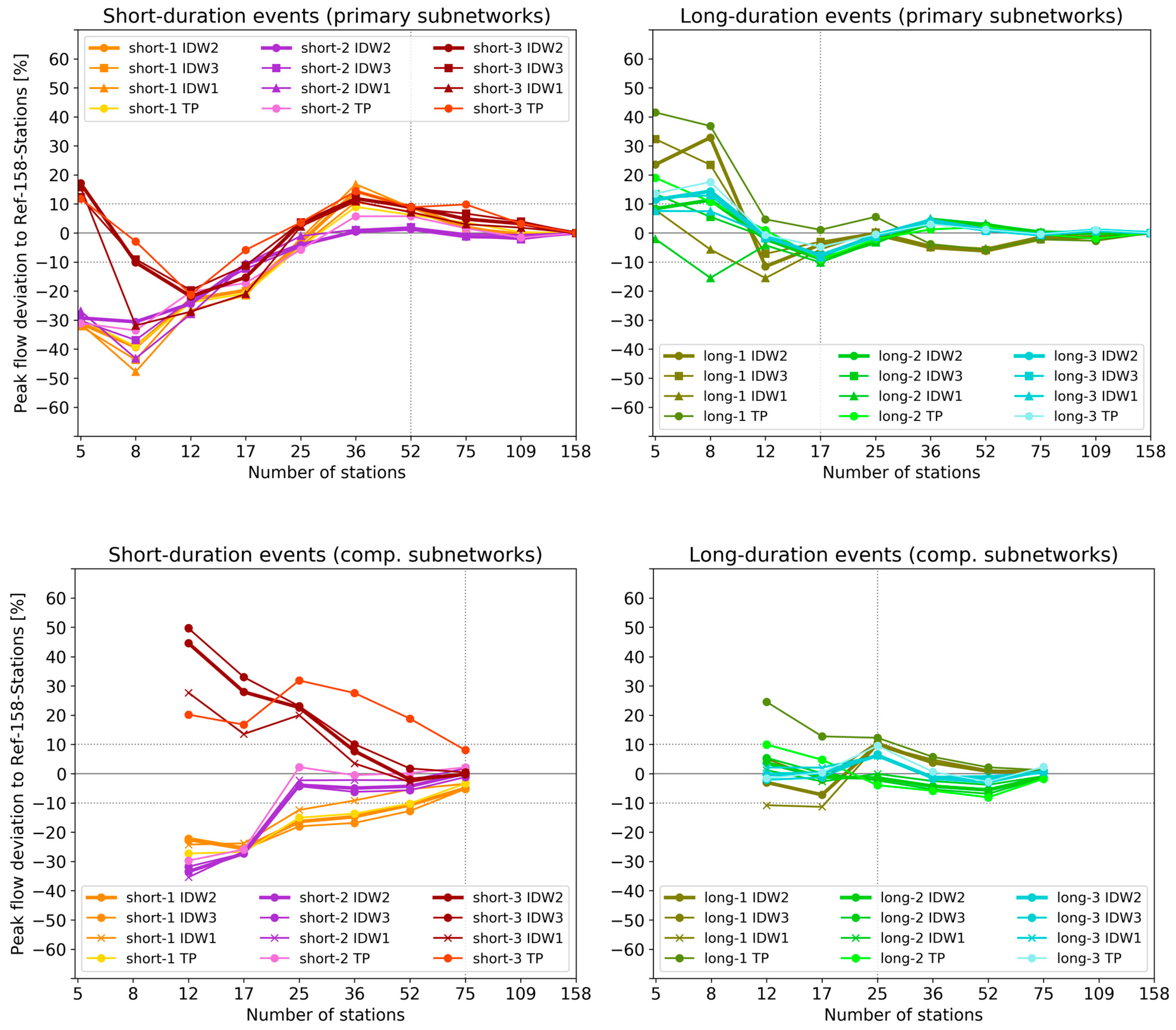
4.2.2. Peak Flow Deviation
5. Discussion
5.1. Threshold Behavior
5.2. Influence of Station Location
5.3. Effect of Timing of Peak Flow
5.4. Comparison of Interpolation Schemes IDW and TP
6. Conclusions
Author Contributions
Funding
Institutional Review Board Statement
Informed Consent Statement
Data Availability Statement
Acknowledgments
Conflicts of Interest
Appendix A


References
- Kharin, V.V.; Zwiers, F.W.; Zhang, X.; Hegerl, G.C. Changes in temperature and precipitation extremes in the IPCC ensemble of global coupled model simulations. J. Clim. 2007, 20, 1419–1444. [Google Scholar] [CrossRef]
- Chen, H.; Sun, J.; Chen, X.; Zhou, W. CGCM projections of heavy rainfall events in China. Int. J. Climatol. 2012, 32, 441–450. [Google Scholar] [CrossRef]
- Fischer, E.M.; Knutti, R. Observed heavy precipitation increase confirms theory and early models. Nat. Clim. Chang. 2016, 6, 986–991. [Google Scholar] [CrossRef]
- Prein, A.F.; Rasmussen, R.M.; Ikeda, K.; Liu, C.; Clark, M.P.; Holland, G.J. The future intensification of hourly precipitation extremes. Nat. Clim. Chang. 2016, 7, 48–52. [Google Scholar] [CrossRef]
- Bárdossy, A.; Das, T. Influence of rainfall observation network on model calibration and application. Hydrol. Earth Syst. Sci. 2008, 12, 77–89. [Google Scholar] [CrossRef]
- Zeng, Q.; Chen, H.; Xu, C.-Y.; Jie, M.-X.; Chen, J.; Guo, S.-L.; Liu, J. The effect of rain gauge density and distribution on runoff simulation using a lumped hydrological modelling approach. J. Hydrol. 2018, 563, 106–122. [Google Scholar] [CrossRef]
- Gilewski, P.; Nawalany, M. Inter-Comparison of Rain-Gauge, Radar, and Satellite (IMERG GPM) Precipitation Estimates Performance for Rainfall-Runoff Modeling in a Mountainous Catchment in Poland. Water 2018, 10, 1665. [Google Scholar] [CrossRef]
- St-Hilaire, A.; Ouarda, T.B.M.J.; Lachance, M.; Bobée, B.; Gaudet, J.; Gignac, C. Assessment of the impact of meteorological network density on the estimation of basin precipitation and runoff: A case study. Hydrol. Process. 2003, 17, 3561–3580. [Google Scholar] [CrossRef]
- Maier, R.; Krebs, G.; Pichler, M.; Muschalla, D.; Gruber, G. Spatial Rainfall Variability in Urban Environments—High-Density Precipitation Measurements on a City-Scale. Water 2020, 12, 1157. [Google Scholar] [CrossRef]
- McMillan, H.K. Effect of spatial variability and seasonality in soil moisture on drainage thresholds and fluxes in a conceptual hydrological model. Hydrol. Process. 2012, 26, 2838–2844. [Google Scholar] [CrossRef]
- Goodrich, D.C.; Faurès, J.-M.; Woolhiser, D.A.; Lane, L.J.; Sorooshian, S. Measurement and analysis of small-scale convective storm rainfall variability. J. Hydrol. 1995, 173, 283–308. [Google Scholar] [CrossRef]
- Huang, Y.; Bárdossy, A.; Zhang, K. Sensitivity of hydrological models to temporal and spatial resolutions of rainfall data. Hydrol. Earth Syst. Sci. 2019, 23, 2647–2663. [Google Scholar] [CrossRef]
- O, S.; Foelsche, U. Assessment of spatial uncertainty of heavy rainfall at catchment scale using a dense gauge network. Hydrol. Earth Syst. Sci. 2019, 23, 2863–2875. [Google Scholar] [CrossRef]
- Kidd, C.; Huffman, G. Review Global precipitation measurement. Meteorol. Appl. 2011, 18, 334–353. [Google Scholar] [CrossRef]
- Sun, X.; Mein, R.G.; Keenan, T.D.; Elliott, J.F. Flood estimation using radar and raingauge data. J. Hydrol. 2000, 239, 4–18. [Google Scholar] [CrossRef]
- Tetzlaff, D.; Uhlenbrook, S. Significance of spatial variability in precipitation for process-oriented modelling: Results from two nested catchments using radar and ground station data. Hydrol. Earth Syst. Sci. 2005, 9, 29–41. [Google Scholar] [CrossRef]
- Tian, Y.; Peters-Lidard, C.D. A global map of uncertainties in satellite-based precipitation measurements. Geophys. Res. Lett. 2010, 37, L24407. [Google Scholar] [CrossRef]
- Kirstetter, P.-E.; Hong, Y.; Gourley, J.J.; Chen, S.; Flamig, Z.; Zhang, J.; Schwaller, M.; Petersen, W.; Amitai, E. Toward a framework for systematic error modeling of spaceborne precipitation radar with NOAA/NSSL ground radar–based national mosaic QPE. J. Hydrometeorol. 2012, 13, 1285–1300. [Google Scholar] [CrossRef]
- O, S.; Foelsche, U.; Kirchengast, G.; Fuchsberger, J.; Tan, J.; Petersen, W.A. Evaluation of GPM IMERG Early, Late, and Final rainfall estimates using WegenerNet gauge data in southeastern Austria. Hydrol. Earth Syst. Sci. 2017, 21, 6559–6572. [Google Scholar] [CrossRef]
- Lasser, M.; O, S.; Foelsche, U. Evaluation of GPM-DPR precipitation estimates with WegenerNet gauge data. Atmos. Meas. Tech. 2019, 12, 5055–5070. [Google Scholar] [CrossRef]
- Ghaemi, E.; Foelsche, U.; Kann, A.; Fuchsberger, J. Evaluation of INCA precipitation analysis using a very dense rain gauge network in southeast Austria. Hydrol. Earth Syst. Sci. Discuss. 2021. in review. [Google Scholar] [CrossRef]
- Lopez, M.G.; Wennerström, H.; Nordén, L.; Seibert, J. Location and density of rain gauges for the estimation of spatial varying precipitation. Geogr. Ann. Ser. A Phys. Geogr. 2015, 97, 167–179. [Google Scholar] [CrossRef]
- Goovaerts, P. Geostatistical approaches for incorporating elevation into the spatial interpolation of rainfall. J. Hydrol. 2000, 228, 113–129. [Google Scholar] [CrossRef]
- Obled, C.; Wendling, J.; Beven, K.J. The sensitivity of hydrological models to spatial rainfall patterns: An evaluation using observed data. J. Hydrol. 1994, 159, 305–333. [Google Scholar] [CrossRef]
- Dong, X.; Dohmen-Janssen, C.M.; Booij, M.J. Appropriate spatial sampling of rainfall or flow simulation. Hydrol. Sci. J. 2005, 50, 279–298. [Google Scholar] [CrossRef]
- Meselhe, E.A.; Habib, E.H.; Oche, O.C.; Gautam, S. Sensitivity of conceptual and physically based hydrologic models to temporal and spatial rainfall sampling. J. Hydrol. Eng. 2009, 14, 711–720. [Google Scholar] [CrossRef]
- Xu, H.; Xu, C.-Y.; Chen, H.; Zhang, Z.; Li, L. Assessing the influence of rain gauge density and distribution on hydrological model performance in a humid region of China. J. Hydrol. 2013, 505, 1–12. [Google Scholar] [CrossRef]
- Zhang, X.; Srinivasan, R. Gis-based spatial precipitation estimation: A comparison of geostatistical approaches. J. Am. Water Resour. Assoc. 2009, 45, 894–906. [Google Scholar] [CrossRef]
- Ly, S.; Charles, C.; Degré, A.; Sarann Ly, C.C.A.D. Different methods for spatial interpolation of rainfall data for operational hydrology and hydrological modeling at watershed scale. A review. Biotechnol. Agron. Société Environ. 2013, 17, 392–406. [Google Scholar]
- Szcześniak, M.; Piniewski, M. Improvement of Hydrological Simulations by Applying Daily Precipitation Interpolation Schemes in Meso-Scale Catchments. Water 2015, 7, 747–779. [Google Scholar] [CrossRef]
- Andréassian, V.; Perrin, C.; Michel, C.; Usart-Sanchez, I.; Lavabre, J. Impact of imperfect rainfall knowledge on the efficiency and the parameters of watershed models. J. Hydrol. 2001, 250, 206–223. [Google Scholar] [CrossRef]
- Kobold, M.; Brilly, M. The use of HBV model for flash flood forecasting. Nat. Hazards Earth Syst. Sci. 2006, 6, 407–417. [Google Scholar] [CrossRef]
- Verworn, A.; Haberlandt, U. Spatial interpolation of hourly rainfall-effect of additional information, variogram inference and storm properties. Hydrol. Earth Syst. Sci. 2011, 15, 569–584. [Google Scholar] [CrossRef]
- Schwarzak, S.; Hänsel, S.; Matschullat, J. Projected changes in extreme precipitation characteristics for Central Eastern Germany (21st century, model-based analysis). Int. J. Climatol. 2015, 35, 2724–2734. [Google Scholar] [CrossRef]
- Breinl, K.; Müller-Thomy, H.; Blöschl, G. Space–time characteristics of areal reduction factors and rainfall processes. J. Hydrometeorol. 2020, 21, 671–689. [Google Scholar] [CrossRef]
- Kirchengast, G.; Kabas, T.; Leuprecht, A.; Bichler, C.; Truhetz, H. WegenerNet: A pioneering high-resolution network for monitoring weather and climate. Bull. Am. Meteorol. Soc. 2014, 95, 227–242. [Google Scholar] [CrossRef]
- Chen, F.W.; Liu, C.W. Estimation of the spatial rainfall distribution using inverse distance weighting (IDW) in the middle of Taiwan. Paddy Water Environ. 2012, 10, 209–222. [Google Scholar] [CrossRef]
- Gilewski, P. Impact of the Grid Resolution and Deterministic Interpolation of Precipitation on Rainfall-Runoff Modeling in a Sparsely Gauged Mountainous Catchment. Water 2021, 13, 230. [Google Scholar] [CrossRef]
- Kurtzman, D.; Navon, S.; Morin, E. Improving interpolation of daily precipitation for hydrologic modelling: Spatial patterns of preferred interpolators. Hydrol. Process. 2009, 23, 3281–3291. [Google Scholar] [CrossRef]
- Dirks, K.N.; Hay, J.E.; Stow, C.D.; Harris, D. High-resolution studies of rainfall on Norfolk Island Part II: Interpolation of rainfall data. J. Hydrol. 1998, 208, 187–193. [Google Scholar] [CrossRef]
- Schroeer, K.; Kirchengast, G. Sensitivity of extreme precipitation to temperature: The variability of scaling factors from a regional to local perspective. Clim. Dyn. 2018, 50, 3981–3994. [Google Scholar] [CrossRef]
- Schulla, J. Hydrologische Modellierung von Flussgebieten zur Abschätzung der Folgen von Klimaänderungen. Ph.D. Thesis, ETH Zurich, Zurich, Switzerland, 1997. [Google Scholar]
- Gervais, M.; Tremblay, L.B.; Gyakum, J.R.; Atallah, E. Representing extremes in a daily gridded precipitation analysis over the United States: Impacts of station density, resolution, and gridding methods. J. Clim. 2014, 27, 5201–5218. [Google Scholar] [CrossRef]
- Avila, F.B.; Dong, S.; Menang, K.P.; Rajczak, J.; Renom, M.; Donat, M.G.; Alexander, L.V. Systematic investigation of gridding-related scaling effects on annual statistics of daily temperature and precipitation maxima: A case study for south-east Australia. Weather Clim. Extrem. 2015, 9, 6–16. [Google Scholar] [CrossRef]
- Herrera, S.; Kotlarski, S.; Soares, P.M.M.M.; Cardoso, R.M.; Jaczewski, A.; Gutiérrez, J.M.; Maraun, D. Uncertainty in gridded precipitation products: Influence of station density, interpolation method and grid resolution. Int. J. Climatol. 2018, 39, 3717–3729. [Google Scholar] [CrossRef]
- Hohmann, C.; Kirchengast, G.; Birk, S. Alpine foreland running drier? Sensitivity of a drought vulnerable catchment to changes in climate, land use, and water management. Clim. Chang. 2018, 147, 179–193. [Google Scholar] [CrossRef]
- O, S.; Foelsche, U.; Kirchengast, G.; Fuchsberger, J. Validation and correction of rainfall data from the WegenerNet high density network in southeast Austria. J. Hydrol. 2018, 556, 1110–1122. [Google Scholar] [CrossRef]
- Haiden, T.; Kann, A.; Wittmann, C.; Pistotnik, G.; Bica, B.; Gruber, C. The integrated nowcasting through comprehensive analysis (INCA) system and its validation over the Eastern Alpine region. Weather Forecast. 2011, 26, 166–183. [Google Scholar] [CrossRef]
- Klebinder, K.; Sotier, B.; Lechner, V.; Strauss, P. Hydrologische und hydropedologische Kenndaten Raabgebiet und Region Südoststeiermark; Department of Natural Hazards, Austrian Research Center for Forests (BFW): Innsbruck, Austria, 2017. [Google Scholar]
- Fuchsberger, J.; Kirchengast, G.; Bichler, C.; Leuprecht, A.; Kabas, T. WegenerNet climate station network Level 2 data version 7.1 (2007–2020). In Wegener Center for Climate and Global Change; University of Graz: Graz, Austria, 2021. [Google Scholar] [CrossRef]
- Krammer, C.; Klebinder, K.; Eder, A.; Sotier, B.; Strauss, P.; Bauer, T. HYDROBOD: Obtaining a GIS-based hydrological soil database and a runoff coefficient calculator for Lower Austria. Forum Geogr. 2016, XV, 100–104. [Google Scholar] [CrossRef]
- Bürger, G.; Schulla, J.; Werner, A.T. Estimates of future flow, including extremes, of the Columbia River headwaters. Water Resour. Res. 2011, 47, 1–18. [Google Scholar] [CrossRef]
- Gädeke, A.; Hölzel, H.; Koch, H.; Pohle, I.; Grünewald, U. Analysis of uncertainties in the hydrological response of a model-based climate change impact assessment in a subcatchment of the Spree River, Germany. Hydrol. Process. 2014, 28, 3978–3998. [Google Scholar] [CrossRef]
- Alaoui, A.; Willimann, E.; Jasper, K.; Felder, G.; Herger, F.; Magnusson, J.; Weingartner, R. Modelling the effects of land use and climate changes on hydrology in the Ursern Valley, Switzerland. Hydrol. Process. 2014, 28, 3602–3614. [Google Scholar] [CrossRef]
- Yira, Y.; Diekkrüger, B.; Steup, G.; Bossa, A.Y. Modeling land use change impacts on water resources in a tropical West African catchment (Dano, Burkina Faso). J. Hydrol. 2016, 537, 187–199. [Google Scholar] [CrossRef]
- Schulla, J. Model Description WaSiM (Water Balance Simulation Model); Hydrology Software Consulting J. Schulla, Zurich, Switzerland 2019. Available online: www.wasim.ch (accessed on 25 March 2021).
- Monteith, J.L. Evaporation and environment. Symp. Soc. Exp. Biol. 1965, 19, 205–234. [Google Scholar] [PubMed]
- van Genuchten, M.T. Closed-form equation for predicting the hydraulic conductivity of unsaturated soils. Soil Sci. Soc. Am. J. 1980, 44, 892–898. [Google Scholar] [CrossRef]
- Nash, J.E.; Sutcliffe, J.V. River flow forecasting through conceptual models part I—A discussion of principles. J. Hydrol. 1970, 10, 282–290. [Google Scholar] [CrossRef]
- Gupta, H.V.; Kling, H.; Yilmaz, K.K.; Martinez, G.F. Decomposition of the mean squared error and NSE performance criteria: Implications for improving hydrological modelling. J. Hydrol. 2009, 377, 80–91. [Google Scholar] [CrossRef]
- Moriasi, D.N.; Arnold, J.G.; Van Liew, M.W.; Bingner, R.L.; Harmel, R.D.; Veith, T.L. Model evaluation guidelines for systematic quantification of accuracy in watershed simulations. Trans. ASABE 2007, 50, 885–900. [Google Scholar] [CrossRef]
- Watson, A.; Kralisch, S.; Künne, A.; Fink, M.; Miller, J. Impact of precipitation data density and duration on simulated flow dynamics and implications for ecohydrological modelling in semi-arid catchments in Southern Africa. J. Hydrol. 2020, 590, 125280. [Google Scholar] [CrossRef]
- Duan, Q.; Sorooshian, S.; Gupta, V.K. Optimal use of the SCE-UA global optimization method for calibrating watershed models. J. Hydrol. 1994, 158, 265–284. [Google Scholar] [CrossRef]
- Schroeer, K.; Tye, M.R. Quantifying damage contributions from convective and stratiform weather types: How well do precipitation and discharge data indicate the risk? J. Flood Risk Manag. 2018. [Google Scholar] [CrossRef]
- Dunkerley, D. Identifying individual rain events from pluviograph records: A review with analysis of data from an Australian dryland site. Hydrol. Process. 2008, 22, 5024–5036. [Google Scholar] [CrossRef]
- Cheng, M.; Wang, Y.; Engel, B.; Zhang, W.; Peng, H.; Chen, X.; Xia, H.; Cheng, M.; Wang, Y.; Engel, B.; et al. Performance Assessment of Spatial Interpolation of Precipitation for Hydrological Process Simulation in the Three Gorges Basin. Water 2017, 9, 838. [Google Scholar] [CrossRef]
- Syed, K.H.; Goodrich, D.C.; Myers, D.E.; Sorooshian, S. Spatial characteristics of thunderstorm rainfall fields and their relation to runoff. J. Hydrol. 2003, 271, 1–21. [Google Scholar] [CrossRef]
- Beven, K.J.; Hornberger, G.M. Assessing the effect of spatial pattern of precipitation in modeling stream flow hydrographs. J. Am. Water Resour. Assoc. 1982, 18, 823–829. [Google Scholar] [CrossRef]
- Fuchsberger, J.; Kirchengast, G.; Kabas, T. WegenerNet high-resolution weather and climate data from 2007 to 2020. Earth Syst. Sci. Data 2021, 13, 1307–1334. [Google Scholar] [CrossRef]
- Kabas, T. WegenerNet climate station network region Feldbach: Experimental setup and high- resolution data for weather and climate research (in German). Wegener Cent. Sci. Rep. 2012, 47, 177. [Google Scholar]
- Lamptey, B.L. Comparison of gridded multisatellite rainfall estimates with gridded gauge rainfall over West Africa. J. Appl. Meteorol. Climatol. 2008, 47, 185–205. [Google Scholar] [CrossRef]
- Schroeer, K.; Kirchengast, G.; O, S. Strong dependence of extreme convective precipitation intensities on gauge network density. Geophys. Res. Lett. 2018, 45, 8253–8263. [Google Scholar] [CrossRef]


| Catchment | Area (km2) | Location from Raab |
|---|---|---|
| Neumarkt/Raab (total catchment) | 987 | - |
| Neumarkt/Raab (focus area) | 488 | - |
| Feldbach/Raab (total catchment) | 689 | - |
| Feldbach/Raab (focus area) | 190 | - |
| Subcatchment | Area (km2) | Location from Raab |
| Auersbach | 28.9 | north |
| Saazerbach | 27.2 | south |
| Giemerbach | 16.0 | south |
| Haselbach | 12.3 | south |
| Kornbach | 12.2 | north |
| Catchment Attributes | Source | Resolution |
|---|---|---|
| Land use types | HYDROBOD | 100 m |
| Soil information | HYDROBOD | 100 m |
| DEM | LStmk, LBgld | 10 m |
| River network | LStmk, LBgld | - |
| Geological information | LStmk, LBgld | - |
| Subcatchments, slope, river width and depth, other information | TANALYS output | 100 m |
| Meteorological Data | Source | Number of Stations |
| Precipitation | WEGN | 150 |
| ZAMG | 5 | |
| AHYD | 3 | |
| Temperature | WEGN | 150 |
| ZAMG | 5 | |
| AHYD | 3 | |
| Relative humidity | WEGN | 150 |
| ZAMG | 5 | |
| AHYD | 3 | |
| Wind speed | WEGN | 12 |
| ZAMG | 5 | |
| Air pressure | WEGN | 1 |
| ZAMG | 5 | |
| Global radiation | ZAMG | 5 |
| Runoff | AHYD | 3 |
| Subnetworks | Gauge Subnetwork Case | Number of Stations (Z/A/W) | Mean Nearest Neighbor Distance (km) |
|---|---|---|---|
| Operational | 5-Stations | 5 (5/-/-) | 11.0 |
| 8-Stations | 8 (5/3/-) | 10.5 | |
| Primary | 12-Stations | 12 (5/3/4) | 7.2 |
| 17-Stations | 17 (5/3/9) | 5.9 | |
| 25-Stations | 25 (5/3/17) | 4.0 | |
| 36-Stations | 36 (5/3/28) | 3.2 | |
| 52-Stations | 52 (5/3/44) | 2.6 | |
| 75-Stations | 75 (5/3/67) | 2.0 | |
| 109-Stations | 109 (5/3/101) | 1.7 | |
| Complementary | 12-comp-Stations | 12 (5/3/4 comp) | 8.3 |
| 17-comp-Stations | 17 (5/3/9 comp) | 5.4 | |
| 25-comp-Stations | 25 (5/3/17 comp) | 4.1 | |
| 36-comp-Stations | 36 (5/3/28 comp) | 3.0 | |
| 52-comp-Stations | 52 (5/3/44 comp) | 2.4 | |
| 75-comp-Stations | 75 (5/3/67 comp) | 2.0 | |
| Reference | Ref-158-Stations | 158 (5/3/150) | 1.4 |
| Event | Start Date | Duration (h) | Total Precipitation (mm) | Peak Hourly Precipitation (mm) | Peak Runoff (m3 s−1) | HQ |
|---|---|---|---|---|---|---|
| short-1 | 10 August 2009 | 4 | 34 | 19 | 107 | HQ1 |
| short-2 | 19 August 2011 | 2 | 23 | 18 | 36 | <HQ1 |
| short-3 | 01 September 2011 | 4 | 28 | 26 | 26 | <HQ1 |
| long-1 | 22 June 2009 | 66 | 121 | 10 | 244 | >HQ10 |
| long-2 | 03 August 2009 | 25 | 106 | 10 | 213 | HQ10 |
| long-3 | 17 September 2010 | 54 | 60 | 5 | 55 | <HQ1 |
| Event | Neumarkt/Raab | Feldbach/Raab | Kornbach | Haselbach | Saazerbach | Auersbach | Giemerbach |
|---|---|---|---|---|---|---|---|
| short-1 | 0 h | 0 h | 0.5 h | 2 h | 3.5 h | 1 h | 2 h |
| short-2 | 0.5 h | 0.5 h | 1.5 h | 1 h | 1.5 h | 0.5 h | 0.5 h |
| short-3 | 3 h | 0.5 h | 1.5 h | 1.5 h | 3.5 h | 1 h | 1.5 h |
| long-1 | 1 h | 1 h | 0.5 h | 2 h | 2 h | 1.5 h | 0.5 h |
| long-2 | 1.5 h | 0.5 h | 2.5 h | 2 h | 1.5 h | 1 h | 1 h |
| long-3 | 15.5 h | 1.5 h | 1 h | 28.5 h | 31 h | 1 h | 1 h |
Publisher’s Note: MDPI stays neutral with regard to jurisdictional claims in published maps and institutional affiliations. |
© 2021 by the authors. Licensee MDPI, Basel, Switzerland. This article is an open access article distributed under the terms and conditions of the Creative Commons Attribution (CC BY) license (https://creativecommons.org/licenses/by/4.0/).
Share and Cite
Hohmann, C.; Kirchengast, G.; O, S.; Rieger, W.; Foelsche, U. Small Catchment Runoff Sensitivity to Station Density and Spatial Interpolation: Hydrological Modeling of Heavy Rainfall Using a Dense Rain Gauge Network. Water 2021, 13, 1381. https://doi.org/10.3390/w13101381
Hohmann C, Kirchengast G, O S, Rieger W, Foelsche U. Small Catchment Runoff Sensitivity to Station Density and Spatial Interpolation: Hydrological Modeling of Heavy Rainfall Using a Dense Rain Gauge Network. Water. 2021; 13(10):1381. https://doi.org/10.3390/w13101381
Chicago/Turabian StyleHohmann, Clara, Gottfried Kirchengast, Sungmin O, Wolfgang Rieger, and Ulrich Foelsche. 2021. "Small Catchment Runoff Sensitivity to Station Density and Spatial Interpolation: Hydrological Modeling of Heavy Rainfall Using a Dense Rain Gauge Network" Water 13, no. 10: 1381. https://doi.org/10.3390/w13101381
APA StyleHohmann, C., Kirchengast, G., O, S., Rieger, W., & Foelsche, U. (2021). Small Catchment Runoff Sensitivity to Station Density and Spatial Interpolation: Hydrological Modeling of Heavy Rainfall Using a Dense Rain Gauge Network. Water, 13(10), 1381. https://doi.org/10.3390/w13101381