Impact of Climate Change on the Hydrological Regimes in Bavaria


Abstract
1. Introduction
2. Study Area and Data
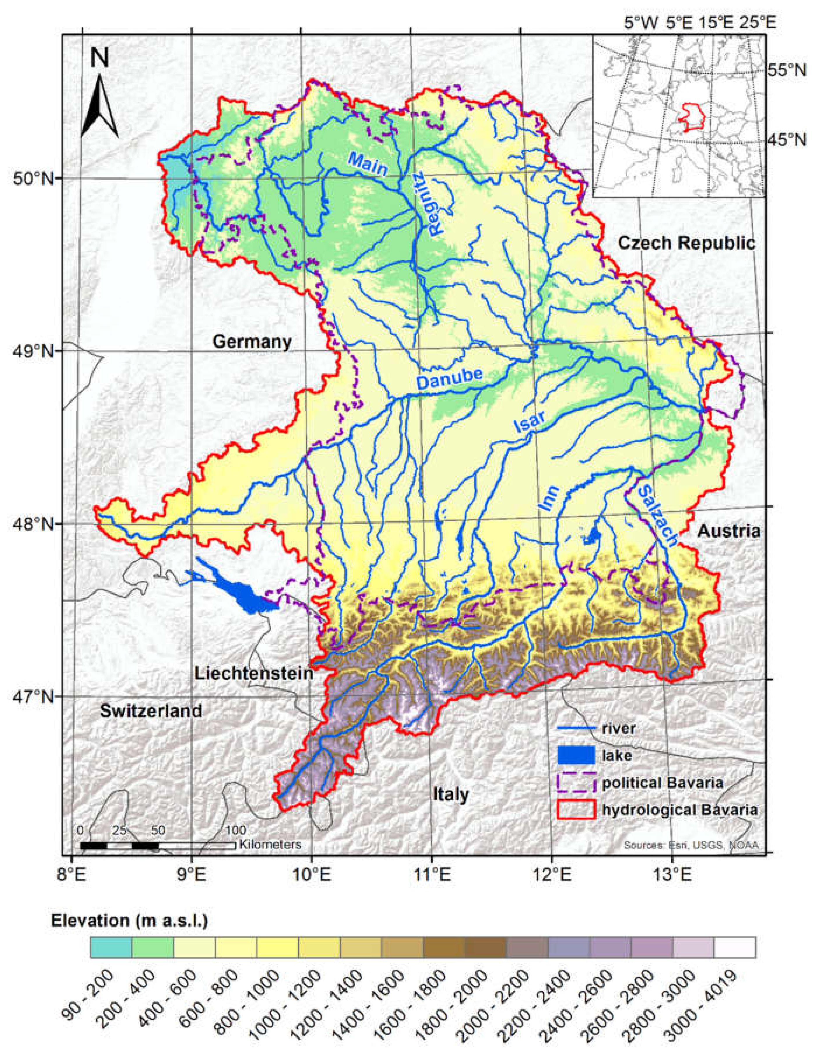
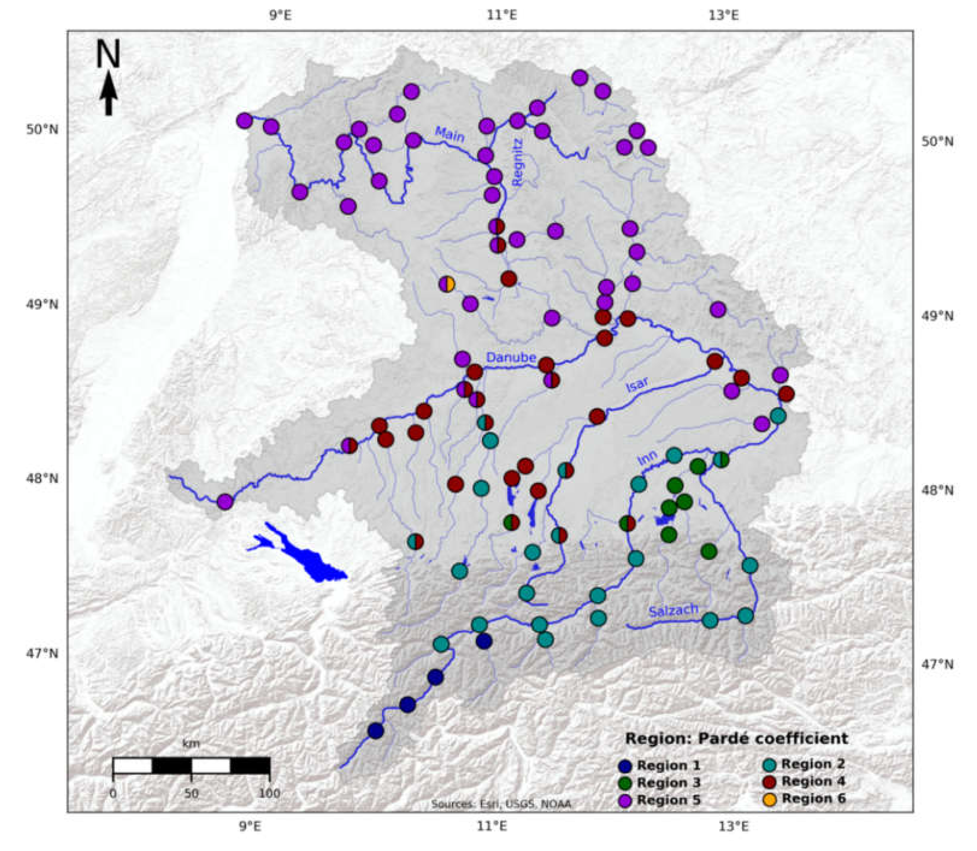
2.1. Study Area
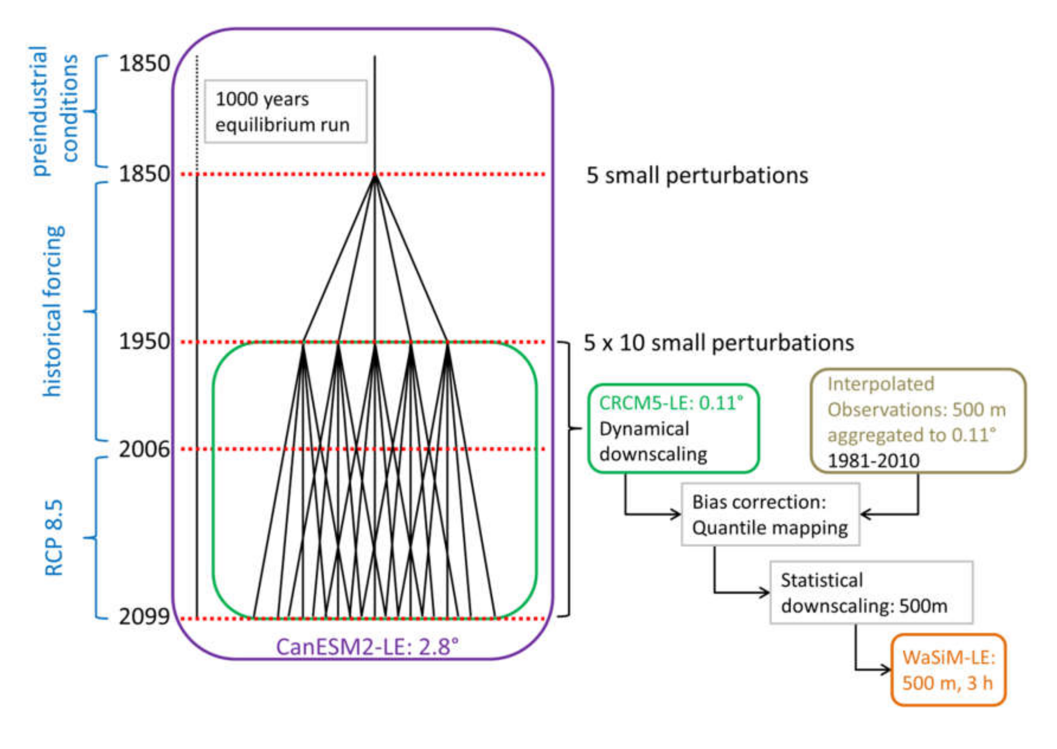
2.2. Data
3. Methods
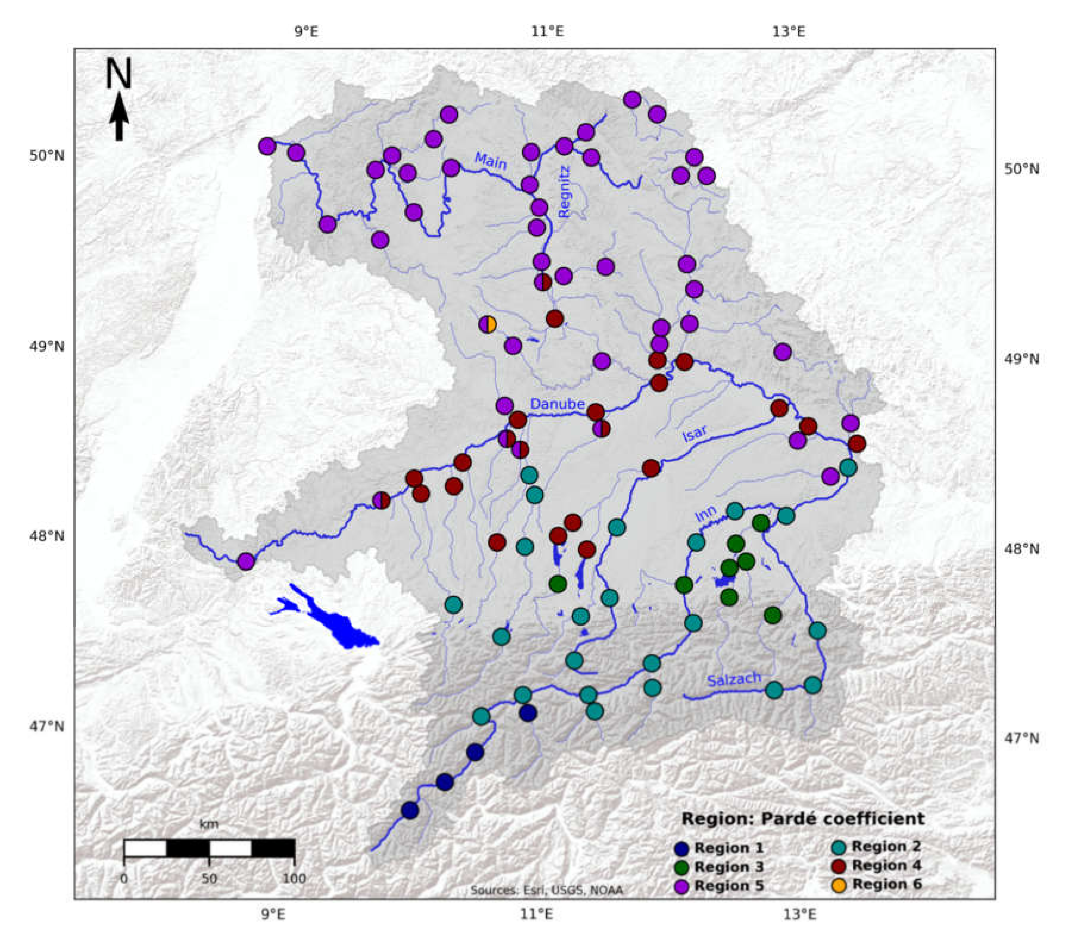
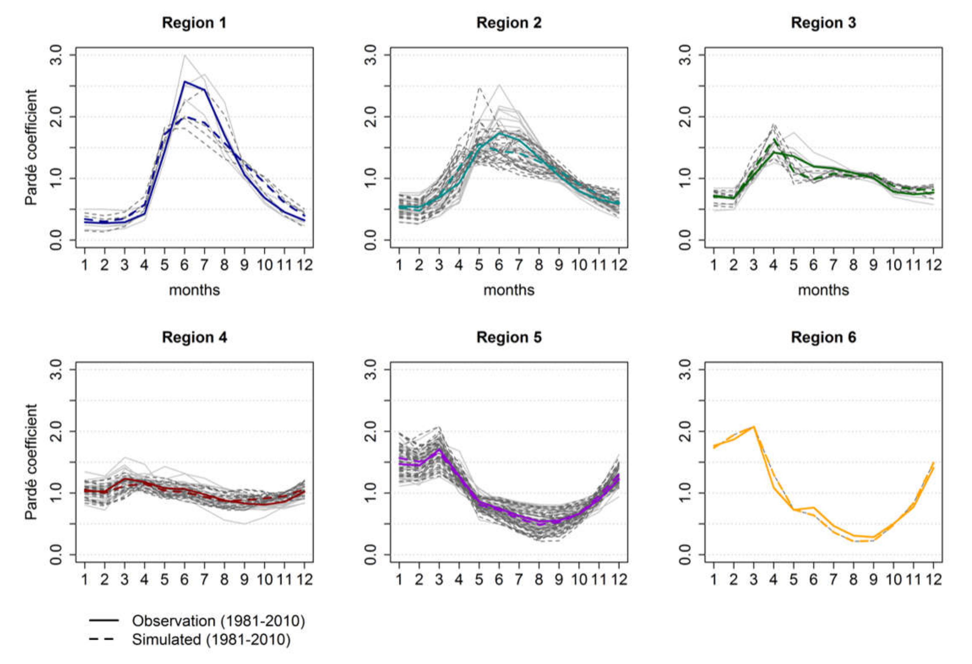
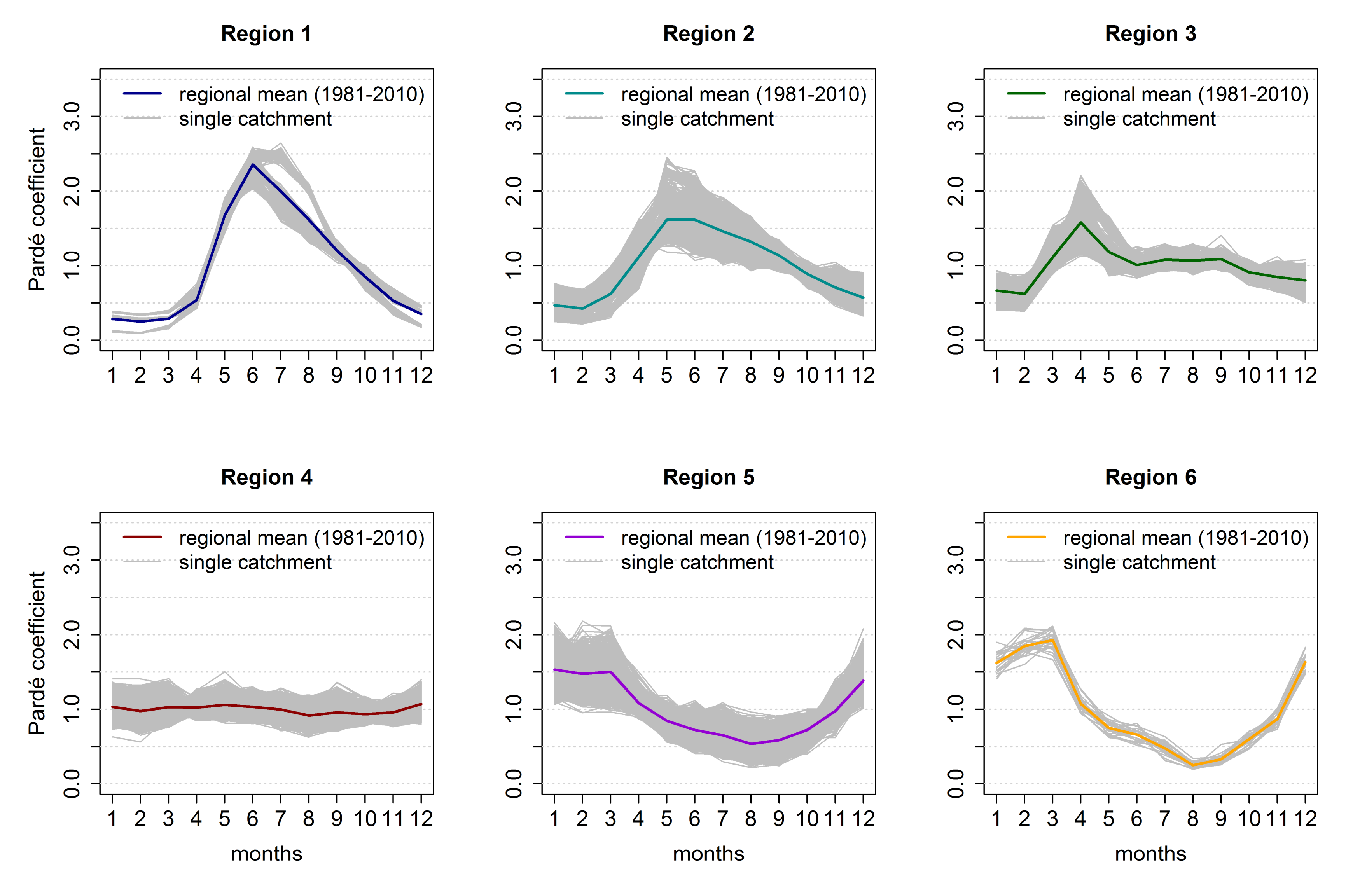
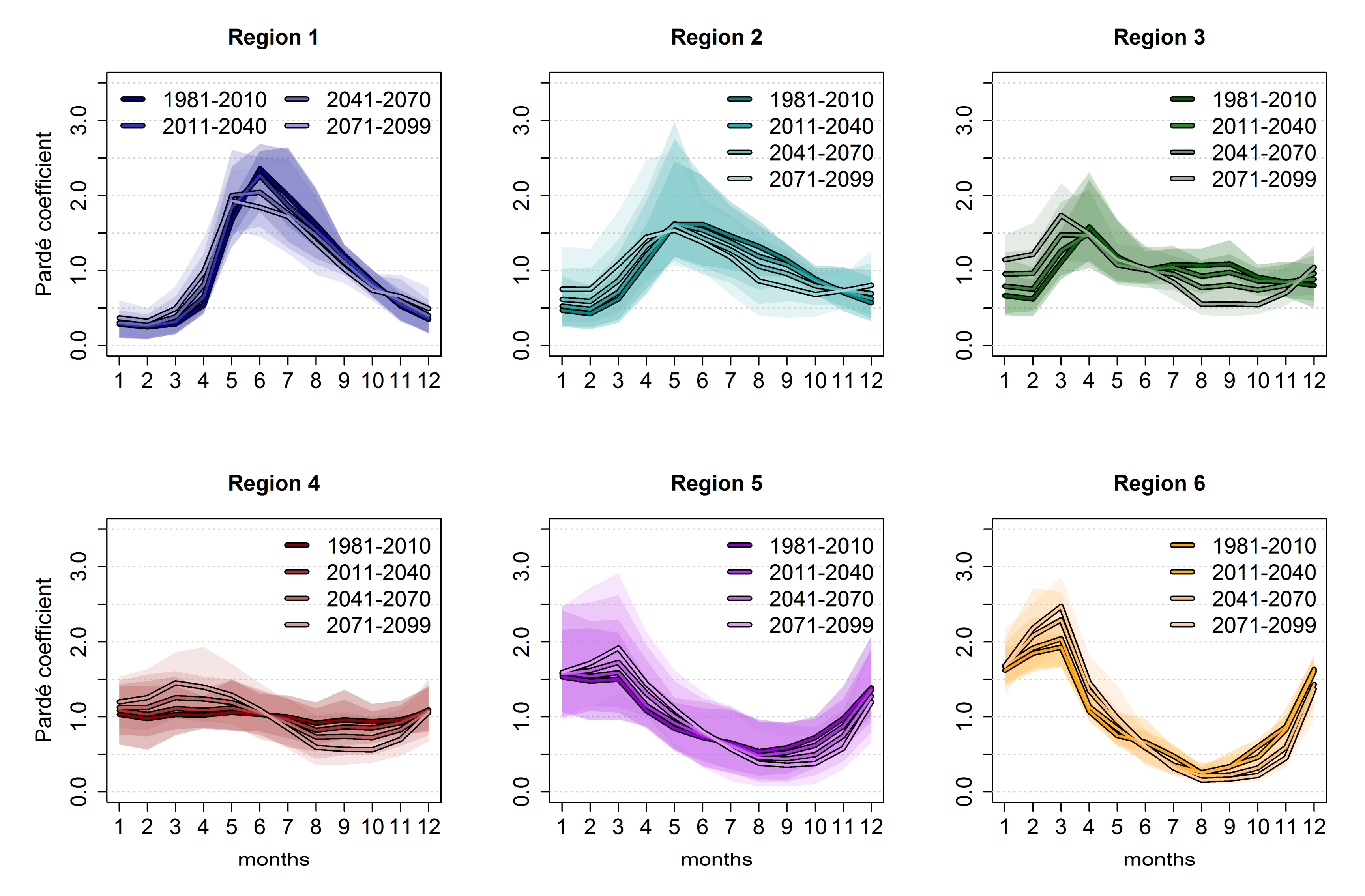
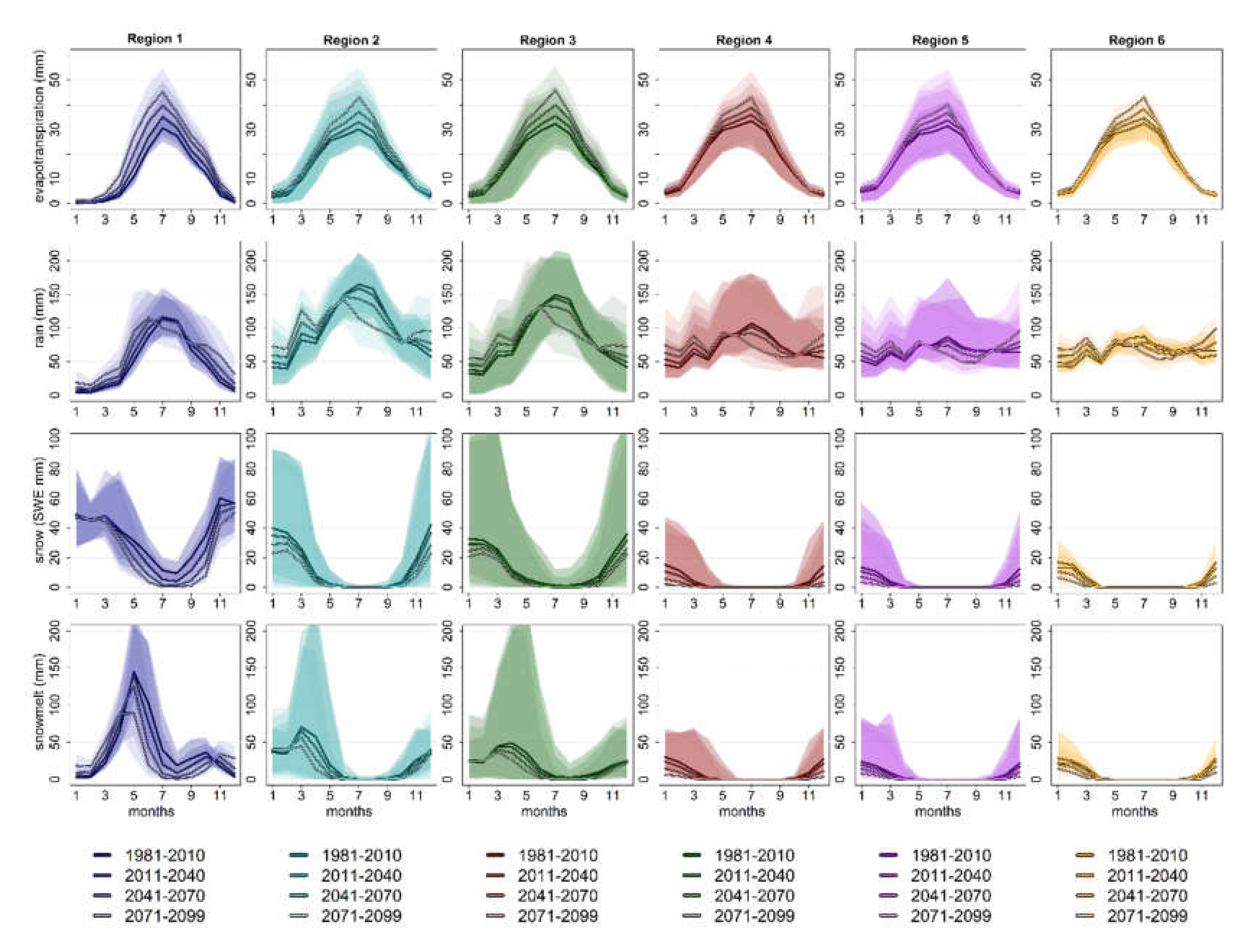
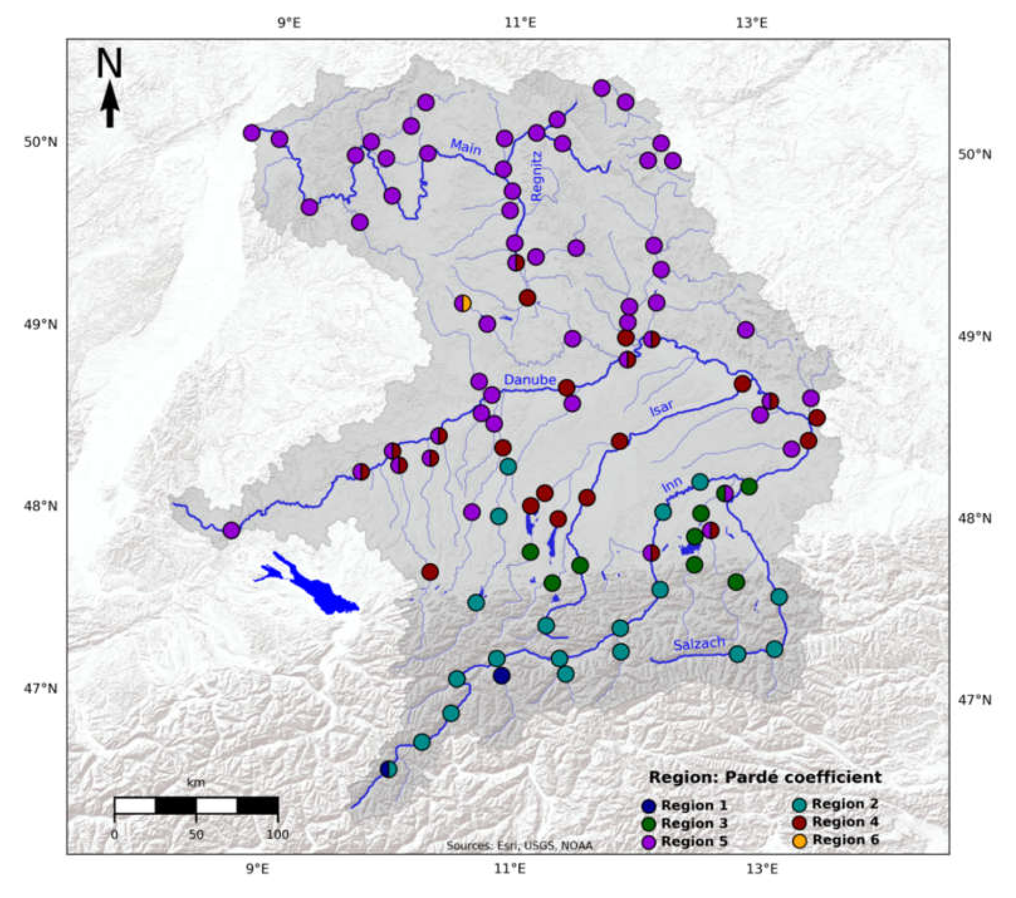
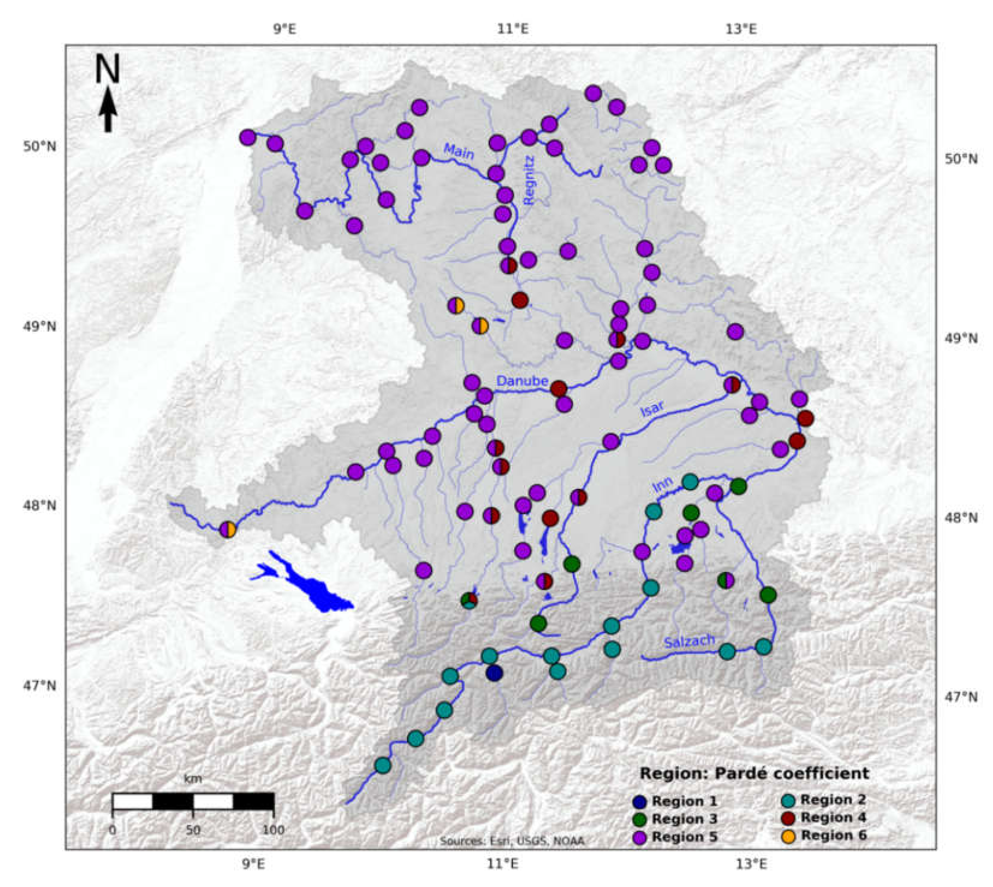
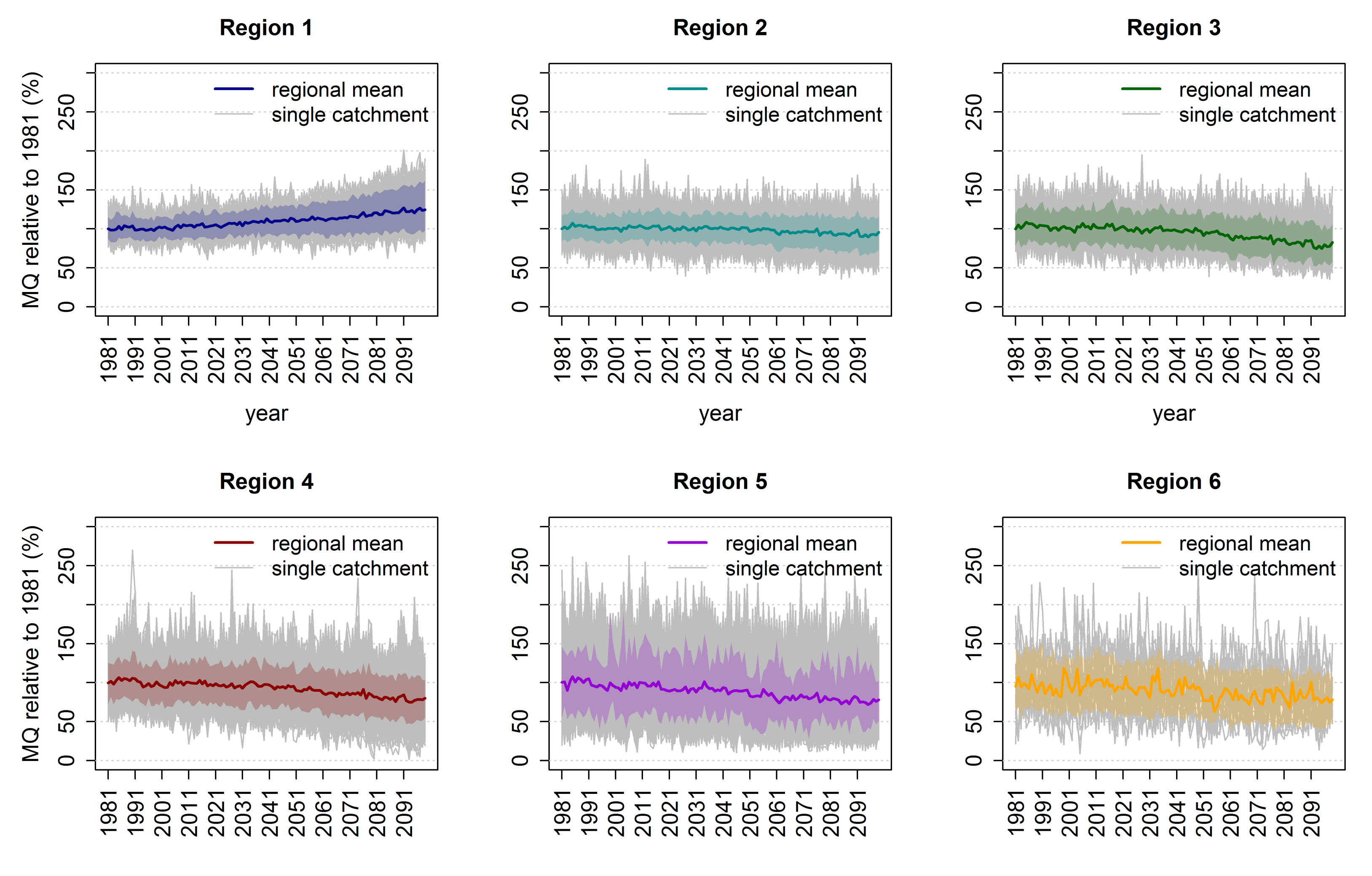
4. Results
5. Discussion
5.1. Advantages of the Clustering Approach
5.2. Socio-Economic Impacts of the Runoff Regime Change in Bavaria
6. Conclusions
Supplementary Materials
Author Contributions
Funding
Acknowledgments
Conflicts of Interest
References
- Messerli, B.; Viviroli, D.; Weingartner, R. Mountains of the World: Vulnerable Water Towers for the 21st Century. In Special Report Number 13. The Royal Colloquium: Mountain Areas: A Global Resource; Springer: Berlin/Heidelberg, Germany, 2004; pp. 29–34. [Google Scholar] [CrossRef]
- Bormann, H. Runoff regime changes in German rivers due to climate change. Erdkunde 2010, 64, 257–279. [Google Scholar] [CrossRef]
- Strasser, U.; Marke, T.; Braun, L.; Escher-Vetter, H.; Juen, I.; Kuhn, M.; Maussion, F.; Mayer, C.; Nicholson, L.; Niedertscheider, K.; et al. The Rofental: A high Alpine research basin (1890 m–3770 m a.s.l.) in the Ötztal Alps (Austria) with over 150 years of hydro-meteorological and glaciological observations. Earth Syst. Sci. Data 2018, 10, 151–171. [Google Scholar] [CrossRef]
- Ionita, M.; Badaluta, C.-A.; Scholz, P.; Chelcea, S. Vanishing river ice cover in the lower part of the Danube basin—Signs of a changing climate. Sci. Rep. 2018, 8, 7948. [Google Scholar] [CrossRef] [PubMed]
- Beniston, M. Impacts of climatic change on water and associated economic activities in the Swiss Alps. J. Hydrol. 2012, 412–413, 291–296. [Google Scholar] [CrossRef]
- Gobiet, A.; Kotlarski, S.; Beniston, M.; Heinrich, G.; Rajczak, J.; Stoffel, M. 21st century climate change in the European Alps—A review. Sci. Total Environ. 2014, 493, 1138–1151. [Google Scholar] [CrossRef]
- Milano, M.; Reynard, E.; Bosshard, N.; Weingartner, R. Simulating future trends in hydrological regimes in Western Switzerland. J. Hydrol. Reg. Stud. 2015, 4, 748–761. [Google Scholar] [CrossRef]
- Stagl, J.; Hattermann, F. Impacts of Climate Change on the Hydrological Regime of the Danube River and Its Tributaries Using an Ensemble of Climate Scenarios. Water 2015, 7, 6139–6172. [Google Scholar] [CrossRef]
- Rojas, R.; Feyen, L.; Bianchi, A.; Dosio, A. Assessment of future flood hazard in Europe using a large ensemble of bias-corrected regional climate simulations. J. Geophys. Res. 2012, 117, D17109. [Google Scholar] [CrossRef]
- Schneider, C.; Laizé, C.L.R.; Acreman, M.C.; Flörke, M. How will climate change modify river flow regimes in Europe? Hydrol. Earth Syst. Sci. 2013, 17, 325–339. [Google Scholar] [CrossRef]
- Köplin, N.; Viviroli, D.; Schädler, B.; Weingartner, R. How does climate change affect mesoscale catchments in Switzerland?—A framework for a comprehensive assessment. Adv. Geosci. 2010, 27, 111–119. [Google Scholar] [CrossRef]
- Pardé, M. Fleuves et Rivières; Armand Colin: Paris, France, 1933; p. 224. [Google Scholar]
- Gaudry, M.M.C.; Gutknecht, D.; Parajka, J.; Perdigão, R.A.P.; Blöschl, G. Seasonality of runoff and precipitation regimes along transects in Peru and Austria. J. Hydr. Hydromech. 2017, 65, 347–358. [Google Scholar] [CrossRef]
- Cañedo-Argüelles, M.; Kefford, B.J.; Piscart, C.; Prat, N.; Schäfer, R.B.; Schulz, C.-J. Salinisation of rivers: An urgent ecological issue. Environ. Pollut. 2013, 173, 157–167. [Google Scholar] [CrossRef] [PubMed]
- Poff, N.L.; Allan, J.D.; Bain, M.B.; Karr, J.R.; Prestegaard, K.L.; Richter, B.D.; Sparks, R.E.; Stromberg, J.C. The Natural Flow Regime. A paradigm for river conservation and restoration. BioScience 1997, 47, 769–784. [Google Scholar] [CrossRef]
- Poff, N.L.; Zimmerman, J.K.H. Ecological responses to altered flow regimes: A literature review to inform the science and management of environmental flows. Freshw. Biol. 2010, 55, 194–205. [Google Scholar] [CrossRef]
- Bruckerhoff, L.A.; Leasure, D.R.; Magoulick, D.D. Flow–ecology relationships are spatially structured and differ among flow regimes. J. Appl. Ecol. 2019, 56, 398–412. [Google Scholar] [CrossRef]
- Schleuter, M. Computing the degradation of riparian floodplains by means of a water-level difference curve. Hydrol. Wasserbewirtsch. 2010, 54, 360–367. [Google Scholar]
- Gaudard, L.; Romerio, F. The future of hydropower in Europe: Interconnecting climate, markets and policies. Environ. Sci. Policy 2014, 37, 172–181. [Google Scholar] [CrossRef]
- Koch, F.; Prasch, M.; Bach, H.; Mauser, W.; Appel, F.; Weber, M. How Will Hydroelectric Power Generation Develop under Climate Change Scenarios? A Case Study in the Upper Danube Basin. Energies 2011, 4, 1508–1541. [Google Scholar] [CrossRef]
- Koch, H.; Vögele, S. Dynamic modelling of water demand, water availability and adaptation strategies for power plants to global change. Ecol. Econ. 2009, 68, 2031–2039. [Google Scholar] [CrossRef]
- Bär, R.; Rouholahnejad, E.; Rahman, K.; Abbaspour, K.C.; Lehmann, A. Climate change and agricultural water resources: A vulnerability assessment of the Black Sea catchment. Environ. Sci. Policy 2015, 46, 57–69. [Google Scholar] [CrossRef]
- Jonkeren, O.; Rietveld, P.; van Ommeren, J.; te Linde, A. Climate change and economic consequences for inland waterway transport in Europe. Reg. Environ. Chang. 2014, 14, 953–965. [Google Scholar] [CrossRef]
- Nilson, E.; Krahe, P. Navigation on the rhine river and climate change. Geogr. Rundsch. 2013, 65, 26–33. [Google Scholar]
- Stoelzle, M.; Blauhut, V.; Kohn, I.; Weiler, M.; Stahl, K. Niedrigwasser in Süddeutschland Analysen, Szenarien und Handlungsempfehlungen; Arbeitskreis KLIWA, Ed.; Bayerisches Landesamt für Umwelt: Hof, Germany, 2018; p. 95. [Google Scholar]
- Ehsani, N.; Vörösmarty, C.J.; Fekete, B.M.; Stakhiv, E.Z. Reservoir operations under climate change: Storage capacity options to mitigate risk. J. Hydrol. 2017, 555, 435–446. [Google Scholar] [CrossRef]
- Fatichi, S.; Rimkus, S.; Burlando, P.; Bordoy, R.; Molnar, P. High-resolution distributed analysis of climate and anthropogenic changes on the hydrology of an Alpine catchment. J. Hydrol. 2015, 525, 362–382. [Google Scholar] [CrossRef]
- Willkofer, F.; Schmid, F.-J.; Komischke, H.; Korck, J.; Braun, M.; Ludwig, R. The impact of bias correcting regional climate model results on hydrological indicators for Bavarian catchments. J. Hydrol. Reg. Stud. 2018, 19, 25–41. [Google Scholar] [CrossRef]
- Deser, C.; Phillips, A.; Bourdette, V.; Teng, H. Uncertainty in climate change projections: The role of internal variability. Clim. Dyn. 2012, 38, 527–546. [Google Scholar] [CrossRef]
- Hawkins, E.; Sutton, R. The potential to narrow uncertainty in regional climate predictions. Bull. Am. Meteorol. Soc. 2009, 90, 1095–1108. [Google Scholar] [CrossRef]
- Von Trentini, F.; Leduc, M.; Ludwig, R. Assessing natural variability in RCM signals: Comparison of a multi model EURO-CORDEX ensemble with a 50-member single model large ensemble. Clim. Dyn. 2019, 53, 1963–1979. [Google Scholar] [CrossRef]
- Martel, J.-L.; Mailhot, A.; Brissette, F.; Caya, D. Role of Natural Climate Variability in the Detection of Anthropogenic Climate Change Signal for Mean and Extreme Precipitation at Local and Regional Scales. J. Clim. 2018, 31, 4241–4263. [Google Scholar] [CrossRef]
- Leduc, M.; Mailhot, A.; Frigon, A.; Martel, J.-L.; Ludwig, R.; Brietzke, G.; Giguère, M.; Brissette, F.; Turcotte, R.; Braun, M.; et al. The ClimEx Project: A 50-Member Ensemble of Climate Change Projections at 12-km Resolution over Europe and Northeastern North America with the Canadian Regional Climate Model (CRCM5). J. Appl. Meteorol. Clim. 2019, 58, 663–693. [Google Scholar] [CrossRef]
- Coppola, E.; Raffaele, F.; Giorgi, F. Impact of climate change on snow melt driven runoff timing over the Alpine region. Clim. Dyn. 2018, 51, 1259–1273. [Google Scholar] [CrossRef]
- Farinotti, D.; Usselmann, S.; Huss, M.; Bauder, A.; Funk, M. Runoff evolution in the Swiss Alps: Projections for selected high-alpine catchments based on ENSEMBLES scenarios. Hydrol. Process. 2012, 26, 1909–1924. [Google Scholar] [CrossRef]
- Döll, P.; Schmied, H.M. How is the Impact of Climate Change on River Flow Regimes Related to the Impact on Mean Annual Runoff? A Global-Scale Analysis; IOP Publishing Ltd: Bristol, UK, 2012; Volume 7. [Google Scholar] [CrossRef]
- Hanzer, F.; Förster, K.; Nemec, J.; Strasser, U. Projected cryospheric and hydrological impacts of 21st century climate change in the Ötztal Alps (Austria) simulated using a physically based approach. Hydrol. Earth Syst. Sci. 2018, 22, 1593–1614. [Google Scholar] [CrossRef]
- Addor, N.; Rössler, O.; Köplin, N.; Huss, M.; Weingartner, R.; Seibert, J. Robust changes and sources of uncertainty in the projected hydrological regimes of Swiss catchments. Water Resour. Res. 2014, 50, 7541–7562. [Google Scholar] [CrossRef]
- Ludwig, R.; May, I.; Turcotte, R.; Vescovi, L.; Braun, M.; Cyr, J.-F.; Fortin, L.-G.; Chaumont, D.; Biner, S.; Chartier, I.; et al. The role of hydrological model complexity and uncertainty in climate change impact assessment. Adv. Geosci. 2009, 21, 63–71. [Google Scholar] [CrossRef]
- Velázquez, J.A.; Schmid, J.; Ricard, S.; Muerth, M.; Gauvin St-Denis, B.; Minville, M.; Chaumont, D.; Caya, D.; Ludwig, R.; Turcotte, R. An ensemble approach to assess hydrological models’ contribution to uncertainties in the analysis of climate change impact on water resources. Hydrol. Earth Syst. Sci. 2013, 17, 565–578. [Google Scholar] [CrossRef]
- Meyer, J.; Kohn, I.; Stahl, K.; Hakala, K.; Seibert, J.; Cannon, A.J. Effects of univariate and multivariate bias correction on hydrological impact projections in alpine catchments. Hydrol. Earth Syst. Sci. 2019, 23, 1339–1354. [Google Scholar] [CrossRef]
- Champagne, O.; Arain, A.; Leduc, M.; Coulibaly, P.; McKenzie, S. Future shift in winter streamflow modulated by internal variability of climate in southern Ontario. Hydrol. Earth Syst. Sci. Discuss. 2019, 1–30. [Google Scholar] [CrossRef]
- Shiogama, H.; Hirata, R.; Hasegawa, T.; Fujimori, S.; Ishizaki, N.N.; Chatani, S.; Watanabe, M.; Mitchell, D.; Lo, Y.T.E. Historical and future anthropogenic warming effects on droughts, fires and fire emissions of CO2 and PM2.5 in equatorial Asia when 2015-like El Niño events occur. Earth Syst. Dynam. 2020, 11, 435–445. [Google Scholar] [CrossRef]
- Barcikowska, M.J.; Muñoz, Á.G.; Weaver, S.J.; Russo, S.; Wehner, M. On the potential impact of a half-degree warming on cold and warm temperature extremes in mid-latitude North America. Environ. Res. Lett. 2019, 14, 124040. [Google Scholar] [CrossRef]
- Ohba, M. The Impact of Global Warming on Wind Energy Resources and Ramp Events in Japan. Atmosphere 2019, 10, 265. [Google Scholar] [CrossRef]
- Hosking, J.S.; MacLeod, D.; Phillips, T.; Holmes, C.R.; Watson, P.; Shuckburgh, E.F.; Mitchell, D.M. Changes in European wind energy generation potential within a 1.5 °C warmer world. Environ. Res. Lett. 2018, 14, 054032. [Google Scholar] [CrossRef]
- Iizumi, T.; Shiogama, H.; Imada, Y.; Hanasaki, N.; Takikawa, H.; Nishimori, M. Crop production losses associated with anthropogenic climate change for 1981–2010 compared with preindustrial levels. Int. J. Climatol. 2018, 38, 5405–5417. [Google Scholar] [CrossRef]
- Schleussner, C.F.; Deryng, D.; Müller, C.; Elliott, J.; Saeed, F.; Folberth, C.; Liu, W.; Wang, X.; Pugh, T.A.M.; Thiery, W.; et al. Crop productivity changes in 1.5 °C and 2 °C worlds under climate sensitivity uncertainty. Environ. Res. Lett. 2018, 13, 064007. [Google Scholar] [CrossRef]
- Gaupp, F.; Hall, J.; Mitchell, D.; Dadson, S. Increasing risks of multiple breadbasket failure under 1.5 and 2 °C global warming. Agric. Syst. 2019, 175, 34–45. [Google Scholar] [CrossRef]
- Faye, B.; Webber, H.; Naab, J.B.; MacCarthy, D.S.; Adam, M.; Ewert, F.; Lamers, J.P.A.; Schleussner, C.-F.; Ruane, A.; Gessner, U.; et al. Impacts of 1.5 versus 2.0 °C on cereal yields in the West African Sudan Savanna. Environ. Res. Lett. 2018, 13, 034014. [Google Scholar] [CrossRef]
- Mohit, M.A.A.; Yamashiro, M.; Hashimoto, N.; Mia, M.B.; Ide, Y.; Kodama, M. Impact Assessment of a Major River Basin in Bangladesh on Storm Surge Simulation. J. Mar. Sci. Eng. 2018, 6, 99. [Google Scholar] [CrossRef]
- Mori, N.; Shimura, T.; Yoshida, K.; Mizuta, R.; Okada, Y.; Fujita, M.; Khujanazarov, T.; Nakakita, E. Future changes in extreme storm surges based on mega-ensemble projection using 60-km resolution atmospheric global circulation model. Coast. Eng. J. 2019, 61, 295–307. [Google Scholar] [CrossRef]
- Uhe, P.F.; Mitchell, D.M.; Bates, P.D.; Sampson, C.C.; Smith, A.M.; Islam, A.S. Enhanced flood risk with 1.5 °C global warming in the Ganges–Brahmaputra–Meghna basin. Environ. Res. Lett. 2019, 14, 074031. [Google Scholar] [CrossRef]
- Schulla, J. Model Description WaSiM (Water Balance Simulation Model); Hydrology Software Consulting J. Schulla: Zürich, Switzerland, 2012; p. 305. [Google Scholar]
- Olden, J.D.; Reidy Liermann, C.A.; Pusey, B.J.; Kennard, M.J. Protocols for Hydrologic Classification and a Review of Australian Applications. In Ecohydrological regionalisation of Australia: A Tool for Management and Science; Land & Water Australia: Canberra, Australia, 2009; pp. 1–28. [Google Scholar]
- Lebiedzinski, K.; Fürst, J. Entwicklung der alpinen Abflussregime in Österreich im Zeitraum 1961–2010. Österr. Wasser Abfallw. 2018, 70, 474–484. [Google Scholar] [CrossRef]
- Berhanu, B.; Seleshi, Y.; Demisse, S.S.; Melesse, A.M. Flow Regime Classification and Hydrological Characterization: A Case Study of Ethiopian Rivers. Water 2015, 7, 3149–3165. [Google Scholar] [CrossRef]
- Copernicus Land Monitoring Service—EU-DEM. Available online: https://www.eea.europa.eu/data-and-maps/data/copernicus-land-monitoring-service-eu-dem (accessed on 24 October 2019).
- Arora, V.K.; Scinocca, J.F.; Boer, G.J.; Christian, J.R.; Denman, K.L.; Flato, G.M.; Kharin, V.V.; Lee, W.G.; Merryfield, W.J. Carbon emission limits required to satisfy future representative concentration pathways of greenhouse gases. Geophys. Res. Lett. 2011, 38, L05805. [Google Scholar] [CrossRef]
- Fyfe, J.C.; Derksen, C.; Mudryk, L.; Flato, G.M.; Santer, B.D.; Swart, N.C.; Molotch, N.P.; Zhang, X.; Wan, H.; Arora, V.K.; et al. Large near-term projected snowpack loss over the western United States. Nat. Comm. 2017, 8, 14996. [Google Scholar] [CrossRef]
- Martynov, A.; Laprise, R.; Sushama, L.; Winger, K.; Šeparović, L.; Dugas, B. Reanalysis-driven climate simulation over CORDEX North America domain using the Canadian Regional Climate Model, version 5: Model performance evaluation. Clim. Dyn. 2013, 41, 2973–3005. [Google Scholar] [CrossRef]
- Šeparović, L.; de Elía, R.; Laprise, R. Impact of spectral nudging and domain size in studies of RCM response to parameter modification. Clim. Dyn. 2012, 38, 1325–1343. [Google Scholar] [CrossRef]
- Dai, A. Precipitation Characteristics in Eighteen Coupled Climate Models. J. Clim. 2006, 19, 4605–4630. [Google Scholar] [CrossRef]
- Kjellström, E.; Boberg, F.; Castro, M.; Christensen, J.H.; Nikulin, G.; Sánchez, E. Daily and monthly temperature and precipitation statistics as performance indicators for regional climate models. Clim. Res. 2010, 44, 135–150. [Google Scholar] [CrossRef]
- Ehret, U.; Zehe, E.; Wulfmeyer, V.; Warrach-Sagi, K.; Liebert, J. “Should we apply bias correction to global and regional climate model data?”. Hydrol. Earth Syst. Sci. 2012, 16, 3391–3404. [Google Scholar] [CrossRef]
- Maraun, D. Bias Correcting Climate Change Simulations—A Critical Review. Curr. Clim. Change Rep. 2016, 2, 211–220. [Google Scholar] [CrossRef]
- Muerth, M.J.; Gauvin St-Denis, B.; Ricard, S.; Valázquez, J.A.; Schmid, J.; Minvie, M.; Caya, D.; Chaumont, D.; Ludwig, R.; Turcotte, R. On the need for bias correction in regional climate scenarios to assess climate change impacts on river runoff. Hydrol. Earth Syst. Sci. 2013, 17, 1189–1204. [Google Scholar] [CrossRef]
- Teutschbein, C.; Seibert, J. Bias correction of regional climate model simulations for hydrological climate-change impact studies: Review and evaluation of different methods. J. Hydrol. 2012, 29, 12–29. [Google Scholar] [CrossRef]
- Mpelasoka, F.S.; Chiew, F.H.S. Influence of Rainfall Scenario Construction Methods on Runoff Projections. J. Hydrometeorol. 2009, 10, 1168–1183. [Google Scholar] [CrossRef]
- Gupta, H.V.; Kling, H.; Yilmaz, K.K.; Martinez, G.F. Decomposition of the mean squared error and NSE performance criteria: Implications for improving hydrological modelling. J. Hydrol. 2009, 377, 80–91. [Google Scholar] [CrossRef]
- Prein, A.F.; Gobiet, A. Impacts of uncertainties in European gridded precipitation observations on regional climate analysis. Int. J. Climatol. 2017, 37, 305–327. [Google Scholar] [CrossRef] [PubMed]
- Rauthe, M.; Steiner, H.; Riediger, U.; Mazurkiewicz, A.; Gratzki, A. A Central European precipitation climatology—Part I: Generation and validation of a high-resolution gridded daily data set (HYRAS). Meteorol. Z. 2013, 22, 235–256. [Google Scholar] [CrossRef]
- Lance, G.N.; Williams, W.T. A general theory of classificatory sorting strategies. 1. Hierarchical systems. Comput. J. 1967, 9, 373–380. [Google Scholar] [CrossRef]
- Sørensen, T.A. A Method of Establishing Groups of Equal Amplitude in Plant Sociology Based on Similarity of Species and its Application to Analyses of the Vegetation on Danish Commons. Biologiske Skrifter 1948, 5, 1–34. [Google Scholar]
- Montero, P.; Vilar, J. TSclust: An R Package for Time Series Clustering. J. Stat. Softw. 2014, 62, 1–43. [Google Scholar] [CrossRef]
- Theodoridis, S.; Koutroumbas, K. Pattern Recognition, 4th ed.; Academic Press: Burlington, VT, USA, 2008; p. 984. [Google Scholar] [CrossRef]
- Charrad, M.; Ghazzali, N.; Boiteau, V.; Niknafs, A. NbClust: An R Package for Determining the Relevant Number of Clusters in a Data Set. J. Stat. Softw. 2014, 61, 1–36. [Google Scholar] [CrossRef]
- Førland, E.J.; Allerup, P.; Dahlström, B.; Elomaa, E.; Jónsson, T.; Madsen, H.; Perälä, J.; Rissanen, P.; Vedin, H.; Vejen, F. Manual for Operational Correction of Nordic Precipitation Data; Norwegian Meteorological Institute: Oslo, Norway, 1996; p. 66. [Google Scholar]
- Goodison, B.E.; Louie, P.Y.T.; Yang, D. WMO Solid Precipitation Measurement Intercomparison; Final Report; World Meteorological Organization: Geneva, Switzerland, 1998; p. 212. [Google Scholar]
- Behrangi, A.; Gardner, A.; Reager, J.T.; Fisher, J.B.; Yang, D.; Huffman, G.J.; Adler, R.F. Using GRACE to Estitmate Snowfall Accumulation and Assess Gauge Undercatch Corrections in High Latitudes. J. Clim. 2018, 31, 8689–8704. [Google Scholar] [CrossRef]
- Grossi, G.; Lendvai, A.; Peretti, G.; Ranzi, R. Snow Precipitation Measured by Gauges: Systematic Error Estimation and Data Series Correction in the Central Italian Alps. Water 2017, 9, 461. [Google Scholar] [CrossRef]
- Isotta, F.A.; Frei, C.; Weilguni, V.; Tadić, M.P.; Lassègues, P.; Rudolf, B.; Pavan, V.; Cacciamani, C.; Antolini, G.; Ratto, S.M.; et al. The climate of daily precipitation in the Alps: Development and analysis of a high-resolution grid dataset from pan-Alpine rain-gauge data. Int. J. Climatol. 2014, 34, 1657–1675. [Google Scholar] [CrossRef]
- Bosshard, T.; Kotlarski, S.; Zappa, M.; Schär, C. Hydrological Climate-Impact Projections for the Rhine River: GCM–RCM Uncertainty and Separate Temperature and Precipitation Effects. J. Hydrometeorol. 2014, 15, 697–713. [Google Scholar] [CrossRef]
- Jenicek, M.; Seibert, J.; Stauinger, M. Modeling of Future Changes in Seasonal Snowpack and Impacts on Summer Low Flows in Alpine Catchments. Water Resour. Res. 2018, 54, 538–556. [Google Scholar] [CrossRef]
- Grimm, F.D. Das Abflußverhalten in Europa: Typen und regionale Gliederung; Verlag Enzyklopädie: Leipzig, Germany, 1968; p. 180. [Google Scholar]
- Mader, H.; Steidl, T.; Wimmer, R. Abflussregime Österreichischer Fließgewässer. Beitrag zu Einer Bundesweiten Fliessgewässertypologie; Umweltbundesamt: Wien, Austria, 1996; p. 192. [Google Scholar]
- Krasovskaia, I.; Gottschalk, L.; Kundzewicz, Z.W. Dimensionality of Scandinavian river flow regimes. Hydrolog. Sci. J. 1999, 44, 705–723. [Google Scholar] [CrossRef]
- Bayerisches Landesamt für Statistik und Datenverarbeitung (Ed.) Betriebswirtschaftliche Ausrichtungen der landwirtschaftlichen Betriebe in Bayern 2013; Bayerisches Landesamt für Statistik und Datenverarbeitung: Munich, Germany, 2014; p. 13. [Google Scholar]
- Bayerische Landesanstalt für Landwirtschaft (Ed.) Bewässerung im Ackerbau und in Gärtnerischen Freilandkulturen; Bayerische Landesanstalt für Landwirtschaft Institut für Agrarökologie, Ökologischen Landbau und Bodenschutz: Freising, Germany, 2008; p. 23. [Google Scholar]
- Wasserentnahmen für die Bewässerung. Available online: https://www.lfu.bayern.de/wasser/bewaesserung/index.htm (accessed on 28 August 2019).
- Drastig, K.; Prochnow, A.; Libra, J.; Koch, H.; Rolinski, S. Irrigation water demand of selected agricultural crops in Germany between 1902 and 2010. Sci. Total Environ. 2016, 569–570, 1299–1314. [Google Scholar] [CrossRef]
- Kreins, P.; Henseler, M.; Anter, J.; Herrmann, F.; Wendland, F. Quantification of Climate Change Impact on Regional Agricultural Irrigation and Groundwater Demand. Water Resour. Manag. 2015, 29, 3585–3600. [Google Scholar] [CrossRef]
- Barthel, R.; Janisch, S.; Nickel, D.; Trifkovic, A.; Hörhan, T. Using the Multiactor-Approach in GLOWA-Danube to Simulate Decisions for theWater Supply Sector Under Conditions of Global Climate Change. Water Resour. Manag. 2010, 24, 239–275. [Google Scholar] [CrossRef]
- Daten & Fakten: Energiedaten Bayern—Kompakt. Available online: https://www.stmwi.bayern.de/energie-rohstoffe/daten-fakten/ (accessed on 29 August 2019).
- Wasserkraft in Bayern. Available online: https://www.lfu.bayern.de/wasser/wasserkraft/index.htm (accessed on 29 August 2019).
- Bundesregierung Beschließt Ausstieg aus der Kernkraft bis 2022. Available online: https://www.bundesregierung.de/breg-de/suche/bundesregierung-beschliesst-ausstieg-aus-der-kernkraft-bis-2022-457246 (accessed on 4 March 2020).
- Bundesministerium für Wirtschaft und Energie (Ed.) Kommission Wachstum, “Strukturwandel und Beschäftigung“ Abschlussbericht; Druck- und Verlagshaus Zarbock: Frankfurt am Main, Germany, 2019; p. 275. [Google Scholar]
- Luft- und Schienenverkehr, Binnenschifffahrt. Available online: https://www.statistik.bayern.de/statistik/wirtschaft_handel/verkehr/index.html (accessed on 30 August 2019).
- Fritsch, F.N.; Carlson, R.E. Monotone piecewise cubic interpolation. SIAM J. Numer. Anal. 1980, 17, 238–246. [Google Scholar] [CrossRef]
- Panagos, P.; Van Liedekerke, M.; Jones, A.; Montanarella, L. European Soil Data Centre: Response to European policy support and public data requirements. Land Use Policy 2012, 29, 329–338. [Google Scholar] [CrossRef]
- CLC 2012 v18. Available online: https://land.copernicus.eu/pan-european/corine-land-cover/clc-2012?tab=metadata (accessed on 8 January 2018).
- Hydrogeologische Übersichtskarte von Deutschland (HÜK250). Available online: https://produktcenter.bgr.de/terraCatalog/OpenSearch.do?search=61ac4628-6b62-48c6-89b8-46270819f0d6&type=/Query/OpenSearch.do (accessed on 6 July 2017).
- Internationale Hydrogeologische Karte von Europa 1:1.500.000 (IHME1500). Available online: https://produktcenter.bgr.de/terraCatalog/OpenSearch.do?search=341255A9-180F-4BF9-B96F-D085339EA86D&type=/Query/OpenSearch.do (accessed on 6 July 2017).
- Warscher, M.; Strasser, U.; Kraller, G.; Marke, T.; Franz, H.; Kunstmann, H. Performance of complex snow cover descriptions in a distributed hydrological model system: A case study for the high Alpine terrain of the Berchtesgaden Alps. Water Resour. Res. 2013, 49, 2619–2637. [Google Scholar] [CrossRef] [PubMed]


| Class | 1 | 1/2 | 2 | 2/3 | 2/3/4 | 3 | 3/4 | 3/5 | 4 | 4/5 | 5 | 5/6 |
|---|---|---|---|---|---|---|---|---|---|---|---|---|
| REF | 4 | 0 | 23 | 0 | 0 | 8 | 0 | 0 | 18 | 5 | 39 | 1 |
| NF | 4 | 0 | 18 | 1 | 0 | 6 | 2 | 0 | 18 | 6 | 42 | 1 |
| MF | 1 | 1 | 18 | 0 | 0 | 8 | 0 | 1 | 13 | 11 | 44 | 1 |
| FF | 1 | 0 | 14 | 0 | 1 | 5 | 0 | 1 | 5 | 8 | 60 | 3 |
| Region 1 | Region 2 | Region 3 | Region 4 | Region 5 | Region 6 | |
|---|---|---|---|---|---|---|
| REF | 4.90% | 2.01% | 2.73% | 3.60% | 5.13% | 6.05% |
| NF | 6.40% | 2.80% | 3.71% | 4.70% | 6.68% | 7.12% |
| MF | 6.84% | 3.00% | 4.27% | 5.82% | 7.26% | 6.87% |
| FF | 7.40% | 3.01% | 4.61% | 6.35% | 7.78% | 7.39% |
© 2020 by the authors. Licensee MDPI, Basel, Switzerland. This article is an open access article distributed under the terms and conditions of the Creative Commons Attribution (CC BY) license (http://creativecommons.org/licenses/by/4.0/).
Share and Cite
Poschlod, B.; Willkofer, F.; Ludwig, R. Impact of Climate Change on the Hydrological Regimes in Bavaria. Water 2020, 12, 1599. https://doi.org/10.3390/w12061599
Poschlod B, Willkofer F, Ludwig R. Impact of Climate Change on the Hydrological Regimes in Bavaria. Water. 2020; 12(6):1599. https://doi.org/10.3390/w12061599
Chicago/Turabian StylePoschlod, Benjamin, Florian Willkofer, and Ralf Ludwig. 2020. "Impact of Climate Change on the Hydrological Regimes in Bavaria" Water 12, no. 6: 1599. https://doi.org/10.3390/w12061599
APA StylePoschlod, B., Willkofer, F., & Ludwig, R. (2020). Impact of Climate Change on the Hydrological Regimes in Bavaria. Water, 12(6), 1599. https://doi.org/10.3390/w12061599