Geomorphic Effects of a Dammed Pleistocene Lake Formed by Landslides along the Upper Yellow River
Abstract
:1. Introduction
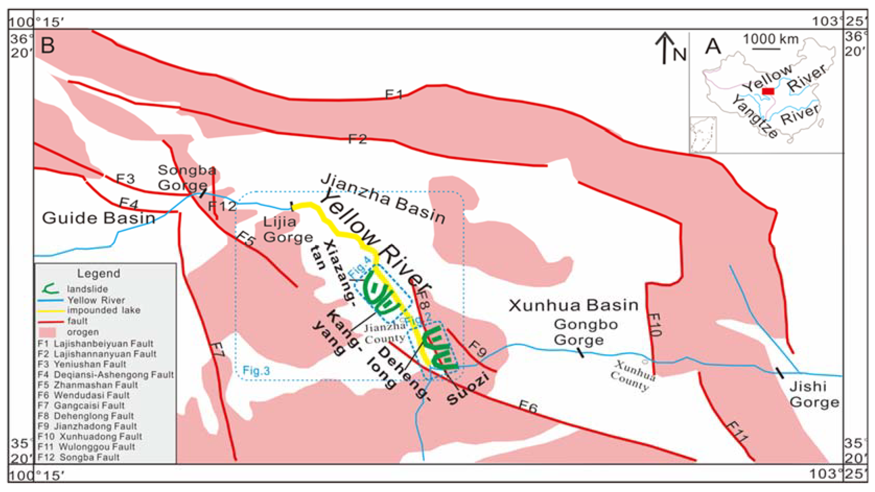
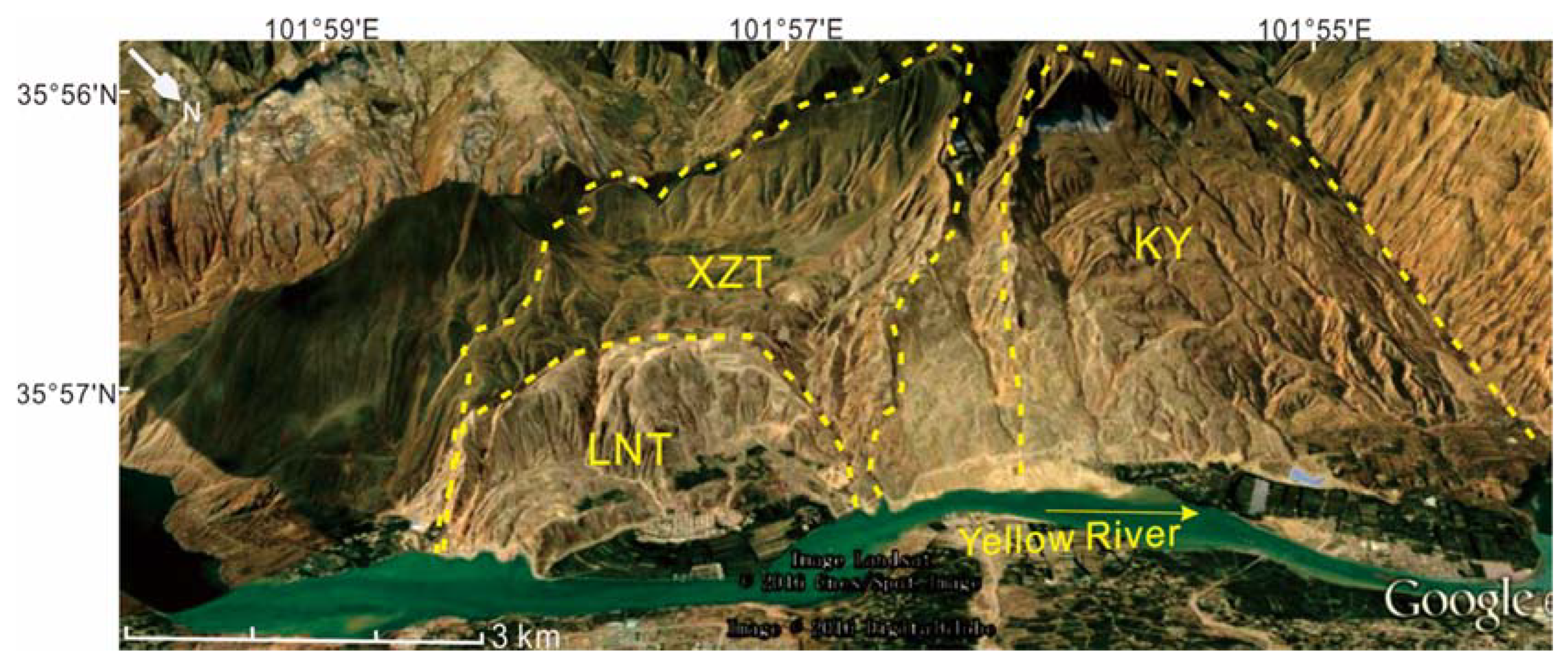
2. Sedimentologyand Tectonic Context
3. Methods
3.1. Stratigraphy and Sampling
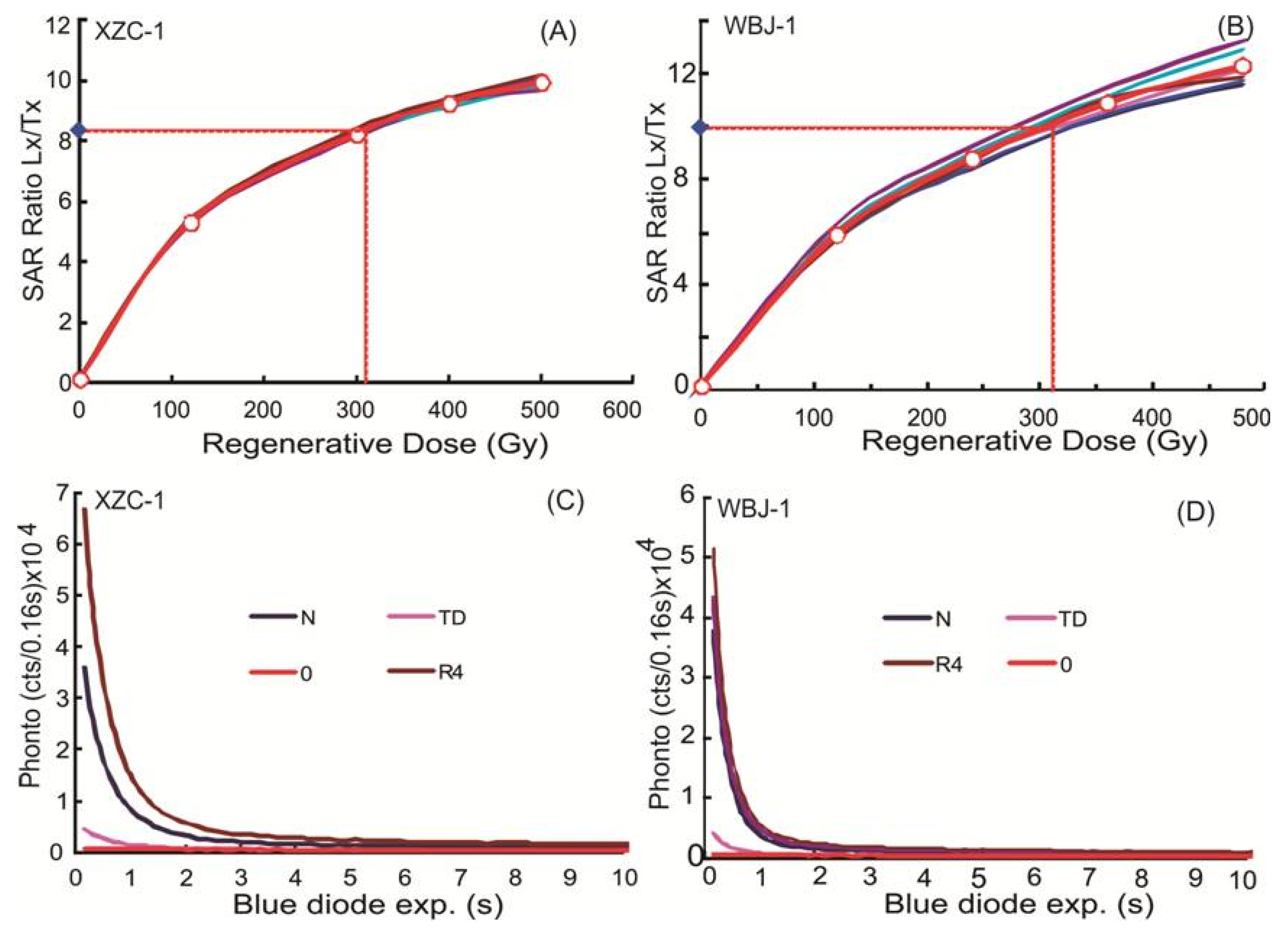
3.2. Optically Stimulated Luminescence (OSL) Dating Method
3.3. Outburst Flood Calculation
4. Results
4.1. Ages of Sampling
4.2. Outburst Flood
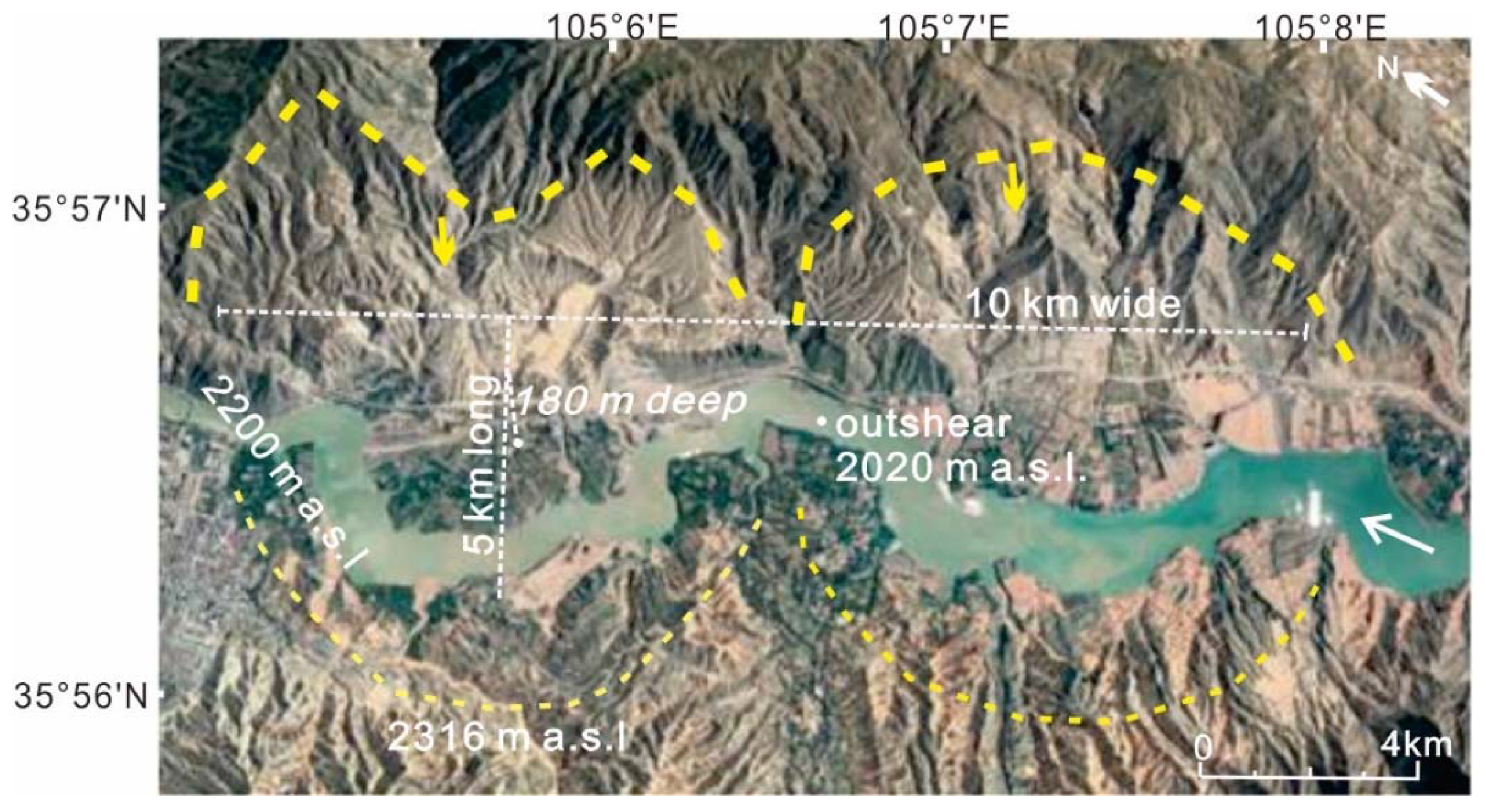
5. Assessing the Landslide-Dammed Lake Volume
6. Discussion
6.1. Neotectonically Causative Factors for Dehenglong-Suozi Landslides
6.2. Geomorphic Effects of Landslides’ Dam Upstream
6.3. Disasters of Subsequent Outburst Flood Downstream
7. Conclusions
Author Contributions
Funding
Conflicts of Interest
Appendix A
| Sample ID | Grain Size | Equivalent | U | Th | K | H2O | Cosmic Dose | Dose Rate | OSL Age | |
|---|---|---|---|---|---|---|---|---|---|---|
| Aliquots | (microns) | Dose (Gray) c | (ppm) d | (ppm) d | (%) d | (%) | (mGray/yr) e | (mGray/yr) | (ka) f | |
| LJX1-1 | 6 a + 14 b | 38–63 | 265.6 ± 8.4 | 3.12 ± 0.14 | 12.12 ± 0.33 | 1.77 ± 0.05 | 10 ± 3 | 0.006 ± 0.000 | 3.08 ± 0.22 | 80 ± 6 |
| LJX1-2 | 6 a + 14 b | 38–63 | 259.5 ± 14.4 | 2.67 ± 0.17 | 11.20 ± 0.28 | 1.93 ± 0.06 | 10 ± 3 | 0.032 ± 0.002 | 3.10 ± 0.22 | 79 ± 7 |
| LJX1-3 | 6 a + 14 b | 38–63 | 225.1 ± 17.8 | 2.65 ± 0.15 | 10.0 ± 0.05 | 1.70 ± 0.06 | 10 ± 3 | 0.150 ± 0.050 | 2.80 ± 0.21 | 75 ± 8 |
| LJX2-1 | 6 a + 14 b | 38–63 | 198.3 ± 9.9 | 1.46 ± 0.11 | 9.4 ± 0.27 | 1.56 ± 0.05 | 10 ± 3 | 0.071± 0.005 | 2.43 ± 0.18 | 76 ± 7 |
| LJX2-2 | 6 a + 14 b | 38–63 | 250.9 ± 10.7 | 1.68 ± 0.11 | 9.64 ± 0.25 | 1.65 ± 0.05 | 10 ± 3 | 0.058 ± 0.004 | 2.55 ± 0.19 | 92 ± 7 |
| LJX2-3 | 6 a + 14 b | 38–63 | 229.3 ± 6.9 | 2.4 ± 0.14 | 9.64 ± 0.28 | 1.62 ± 0.06 | 10 ± 3 | 0.150 ± 0.050 | 2.65 ± 0.19 | 80 ± 9 |
| LJX2-4 | 6 a + 14 b | 38–63 | 232.9 ± 9.8 | 3.7 ± 0.17 | 8.59 ± 0.23 | 1.73 ± 0.06 | 10 ± 3 | 0.150 ±0.050 | 2.95 ± 0.21 | 74 ± 6 |
| LJX3-1 | 6 a + 14 b | 38–63 | 219.4 ± 8.9 | 1.97 ± 0.12 | 8.96 ± 0.25 | 1.48 ± 0.05 | 10 ± 3 | 0.150 ± 0.050 | 2.40 ± 0.18 | 85 ± 7 |
| LJX3-2 | 6 a + 14 b | 38–63 | 222.1 ± 14.9 | 1.97 ± 0.12 | 8.88 ± 0.25 | 1.67 ± 0.05 | 10 ± 3 | 0.150 ± 0.050 | 2.60 ± 0.19 | 80 ± 8 |
| QK1-1 | 6 a + 14 b | 38–63 | 244.5 ± 9.7 | 2.22 ± 0.13 | 9.89 ± 0.27 | 1.47 ± 0.05 | 10 ± 3 | 0.150 ± 0.050 | 2.47 ± 0.18 | 92 ± 8 |
| QK1-2 | 6 a + 14 b | 38–63 | 240.1 ± 10.5 | 2.24 ± 0.13 | 11.1 ± 0.31 | 1.66 ± 0.05 | 10 ± 3 | 0.150 ± 0.050 | 2.71 ± 0.20 | 83 ± 7 |
References
- Korup, O.; Montgomery, D.R. Tibetan plateau river incision inhibited by glacial stabilizationof the Tsangpo gorge. Nature 2008, 455, 786–789. [Google Scholar] [CrossRef]
- Dai, F.C.; Lee, C.F.; Deng, J.H.; Tham, L.G. The 1786 earthquake-triggered landslide dam and subsequent dam-break flood on the Dadu River, southwestern China. Geomorphology 2005, 65, 205–221. [Google Scholar] [CrossRef]
- O’connor, J.E.; Costa, J.E. The World’s Largest Floods, Past and Present: Their Causes and Magnitudes; Geological Survey (USGS): Reston, VA, USA, 2004; p. 1254.
- Wang, H.J.; Yang, Z.S.; Saito, Y.; Liu, J.P.; Sun, X.X. Interannual and seasonal variation of the Huanghe (Yellow River) water discharge over the past 50 years: Connections to impacts from ENSO events and dams. Glob. Planet. Chang. 2006, 50, 212–225. [Google Scholar] [CrossRef]
- Wang, Y.; Herzschuh, U.; Liu, X.; Korup, O.; Diekmann, B. A high-resolution sedimentary archive from landslide-dammed Lake Mengda, north-eastern Tibetan Plateau. J. Paleolimnol. 2012, 51, 303–312. [Google Scholar] [CrossRef]
- Wang, P.; Chen, J.; Dai, F.; Long, W.; Xu, C.; Sun, J.; Cui, Z. Chronology of relict lake deposits around the Suwalong paleolandslide in the upper Jinsha River, SE Tibetan Plateau: Implications to Holocene tectonic perturbations. Geomorphology 2014, 217, 193–203. [Google Scholar] [CrossRef]
- Chen, Y.Z. Investigation the Flood History of the Yellow River: From Analyzing Historical Records to Computer Modeling. Ph.D. Thesis, Nanjing University, Nanjing, China, 2006. (In Chinese with English abstract). [Google Scholar]
- Liu, W.; Lai, Z.; Hu, K.; Ge, Y.; Cui, P.; Zhang, X.; Liu, F. Age and extent of a giant glacial-dammed lake at Yarlung Tsangpo gorge in the Tibetan Plateau. Geomorphology 2015, 246, 370–376. [Google Scholar] [CrossRef]
- Zhang, Y.; Huang, C.C.; Shulmeister, J.; Guo, Y.; Liu, T.; Kemp, J.; Patton, N.R.; Liu, L.; Chen, Y.; Zhou, Q.; et al. Formation and evolution of the Holocene massive landslide-dammed lakes in the Jishixia Gorges along the upper Yellow River: No relation to China’s Great Flood and the Xia Dynasty. Quat. Sci. Rev. 2019, 218, 267–280. [Google Scholar]
- Korup, O. Effects of large deep-seated landslides on hillslope morphology, western Southern Alps, New Zealand. J. Geophys. Res. Earth Surfaces 2006, 111. [Google Scholar] [CrossRef] [Green Version]
- Ouimet, W.B.; Whipple, K.; Royden, L.; Sun, Z.; Chen, Z. The influence of large landslides on river incision in a transient landscape: Eastern margin of the Tibetan Plateau (Sichuan, China). Geol. Soc. Am. Bull. 2007, 119, 1462–1476. [Google Scholar] [CrossRef] [Green Version]
- Restrepo, C.; Walker, L.R.; Shiel, A.B.; Bussmann, R.; Claessens, L.; Fisch, S.; Lozano, P.; Negi, G.; Paolini, L.; Poveda, G.; et al. Landsliding and its multiscale influence on mountainscapes. Bioscience 2009, 59, 685–698. [Google Scholar] [CrossRef] [Green Version]
- Mackey, B.H.; Roering, J.J.; Lamb, M.P. Landslide-dammed paleolake perturbs marine sedimentation and drives genetic change in anadromous fish. Proc. Natl. Acad. Sci. USA 2011, 108, 18905–18909. [Google Scholar] [CrossRef] [Green Version]
- Wu, Q.; Zhao, Z.; Liu, L.; Granger, D.E.; Wang, H.; Cohen, D.J.; Wu, X.; Ye, M.; Yosef, O.; Lu, B.; et al. Outburst flood at 1920 BCE supports historicity of China’s Great Flood and the Xia dynasty. Science 2016, 353, 579–582. [Google Scholar] [CrossRef]
- Guo, X.; Lai, Z.; Sun, Z.; Li, X.; Yang, T. Luminescence dating of Suozi landslide in the Upper Yellow River of the Qinghai-Tibetan Plateau, China. Quat. Int. 2014, 349, 159–166. [Google Scholar] [CrossRef]
- Guo, X.; Lai, Z.; Lu, Y.; Li, X.; Sun, Z. Optically Stimulated Luminescence (OSL) Chronology of the Dehenglong Landslide from Longyang Gorge to Liujia Gorge along Upper YellowRiver. Acta Geol. Sin. Engl. Ed. 2015, 89, 242–250. [Google Scholar]
- Guo, X.; Sun, Z.; Lai, Z.; Lu, Y.; Li, X. Optical dating of landslide-dammed lake deposits in the upper Yellow River, Qinghai-Tibetan Plateau, China. Quat. Int. 2016, 392, 233–238. [Google Scholar] [CrossRef]
- Guo, X.H. OSL Chronology of Giant Landslides from Longyangxia Gorge to Liujia Gorge Along Upper Yellow River. Master’s Thesis, Lanzhou University, Lanzhou, China, 2012. (in Chinese with English Abstract). [Google Scholar]
- Guo, X.; Wei, J.; Song, Z.; Lai, Z.; Yu, L. Optically stimulated luminescence chronology and geomorphic imprint of Xiazangtan landslide upon the upper Yellow River valley on the northeastern Tibetan Plateau. Geol. J. 2020. [Google Scholar] [CrossRef]
- Zhou, B. Research on Development Characteristic and Mass Mechanism of Super Large Landslide in the Upper Yellow River. Ph.D. Thesis, Chang’an University, Xi’an, China, 2011. [Google Scholar]
- Zhou, B.; Hu, G.S.; Peng, J.B.; Lu, B.C. An evaluation on the basis of GIS of risk for landslides from Laganxia Gorge to Sigouxia Gorge. South North Water Transf. Water Sci. Technol. 2010, 8, 36–48, (In Chinese with English abstract). [Google Scholar]
- Li, X.; Guo, X.; Li, W. Mechanism of giant landslides from longyangxia valley to Liujiaxia valley along upper Yellow River. J. Eng. Geol. 2011, 19, 516–529. [Google Scholar]
- Zhao, R.; Zhou, B. The application of optical stimulate luminescence dating to the study of clustered landslides activity. Geol. Bull. Chin. 2013, 32, 26–34, (In Chinese with English abstract). [Google Scholar]
- Higgitt, D.; Zhang, X.B.; Liu, W.M.; Tang, Q.; He, X.B.; Ferrant, S. Giant palaeo-landslide dammed the Yangtze river. Geosci. Lett. 2014, 1, 6. [Google Scholar] [CrossRef]
- Evans, S.G. The maximum discharge of outburst floods caused by the breaching of man-made and natural dams. Can. Geotech.J. 1986, 23, 385–387. [Google Scholar] [CrossRef]
- Korup, O.; Clague, J.J.; Hermanns, R.L.; Hewitt, K.; Strom, A.L.; Weidinger, J.T. Giant n landslides, topography, and erosion. Earth Planet. Sci. Lett. 2007, 261, 578–589. [Google Scholar] [CrossRef]
- Dibiase, R.A.; Whipple, K.X. The influence of erosion thresholds and runoff variability on the relationships among topography, climate, and erosion rate. J. Geo Res.: Earth Surface 2011, 116. [Google Scholar] [CrossRef] [Green Version]
- Langston, A.L.; Temme, A.J.A.M. Bedrock erosion and changes in bed sediment lithology in response to an extreme flood event: The 2013 Colorado Front Range flood. Geomorphology 2019, 328, 1–14. [Google Scholar] [CrossRef]
- Li, J. The environmental effects of the uplift of the Qinghai-Xizang Plateau. Quat. Sci. Rev. 1991, 10, 479–483. [Google Scholar]
- Zhao, Z.; Liu, B. Relation between the formation of the Yellow River valley landforms from Gonghe, Qinghai to Lanzhou, Gansu and the uplifting in northeast part of Qinghai-Xizang plateau. Northwest. Geol. 2003, 36, 1–12. [Google Scholar]
- Craddock, W.; Kirby, E.; Harkins, N.W.; Zhang, H.; Shi, X.; Liu, J. Rapid fluvial incision along the Yellow River during headward basin integration. Nat. Geosci. 2010, 3, 209–213. [Google Scholar] [CrossRef]
- Li, W.; Dong, Y.; Guo, A.; Liu, X.; Zhou, D. Chronology and tectonic significance of Cenozoic faults in the Liupanshan Arcuate Tectonic Belt at the northeastern margin of the Qinghai–Tibet Plateau. J. Asian Earth Sci. 2013, 73, 103–113. [Google Scholar] [CrossRef]
- Guo, X.; Lu, Y.D.; Li, X.L.; Sun, Z.; Li, C.Y.; Zhang, R. Event of Block up upper Yellow River by Dehenglong-Suozi landslides. J. Jilin Univ. Earth Sci. Ed. 2015, 45, 1789–1797. [Google Scholar]
- Aitken, M.J. Introduction to Optical Dating: The Dating of Quaternary Sediments by the Use of Photon-Stimulated Luminescence; Oxford University Press: New York, NY, USA, 1998. [Google Scholar]
- Lai, Z. Chronology and the upper dating limit for loess samples from Luochuan section in the Chinese Loess Plateau using quartz OSL SAR protocol. J. Asian Earth Sci. 2010, 37, 176–185. [Google Scholar] [CrossRef]
- Lai, Z.P.; Wintle, A.G. Locating the boundary between the Pleistocene and the Holocene in Chinese loess using luminescence. Holocene 2006, 16, 893–899. [Google Scholar] [CrossRef]
- Murray, A.S.; Wintle, A.G. The single aliquot regenerative dose protocol: Potential for improvements in reliability. Radiat. Meas. 2003, 37, 377–381. [Google Scholar] [CrossRef]
- Roberts, H.M.; Duller, G.A.T. Standardized growth curves for optical dating of sediment using multiple-grain aliquots. Radiat. Meas. 2004, 38, 241–252. [Google Scholar] [CrossRef]
- Lai, Z.P.; Brückner, H.; Zöllerb, F.A. Existence of a common growth curve for silt-sized quartz OSL of loess from different continents. Radiat. Meas. 2007, 42, 1432–1440. [Google Scholar] [CrossRef]
- Prescott, J.R.; Hutton, J.T. Cosmic ray contributions to dose rates for luminescence and ESR dating: Large depths and long-term time variations. Radiat. Meas. 1994, 23, 497–500. [Google Scholar] [CrossRef]
- Wintle, A.G.; Murray, A.S. A review of quartz optically stimulated luminescence characteristics and their relevance in single-aliquot regeneration dating protocols. Radiat. Meas. 2006, 41, 369–391. [Google Scholar] [CrossRef]
- Costa, J.E.; Schuster, R.L. The formation and failure of natural dams. Geol. Soc. Am. Bull. 1998, 100, 1054–1068. [Google Scholar] [CrossRef]
- Connor, J.E.; Beebee, R.A. Floods from natural rock-material dams. Megaflooding on Earth, Mars; Cambridge University Press: New York, NY, USA, 2009; pp. 128–163. [Google Scholar]
- Chow, V.T. Open-Channel Hydraulics; McGraw-Hill: New York, NY, USA, 1959; pp. 40–59. [Google Scholar]
- Lu, Y.C.; Wang, X.L.; Wintle, A.G. A new OSL chronology for dust accumulation in the last 130,000 year for the Chinese Loess Plateau. Quart. Res. 2007, 67, 152–160. [Google Scholar] [CrossRef]
- Lv, B.C. Report on Validation for Basically Seismic Intensity and Risk for Engineering Earthquakes in Lijia Power Station along Yellow River; Qinghai University Press: Xining, China, 1989. [Google Scholar]
- Korup, O.; Densmore, A.L.; Schlunegger, F. The role of landslides in mountain range evolution. Geomorphology 2010, 120, 77–90. [Google Scholar] [CrossRef]
- Guo, X.; Forman, S.L.; Marin, L.; Li, X. Assessing tectonic and climatic controls for Late Quaternary fluvial terraces in Guide, Jianzha, and Xunhua Basins along the Yellow River on the northeastern Tibetan Plateau. Quat. Sci. Rev. 2018, 195, 109–121. [Google Scholar] [CrossRef]
- Albu, L.M.; Enea, A.; Toleriu, C.C.S.; Niacsu, L.G.I.S. Implementation on Dam-Break Flood Vulnerability Analysis—A Case Study of Cătămărăști Dam, Botoșani, Romania. In Proceedings of the Air and Water-Components of the Environment, Cluj-Napoca, Romania, July 2019; pp. 65–75. [Google Scholar] [CrossRef]
- Macklin, M.; Brewer, P.; Balteanu, D.; Coulthard, T.; Driga, B.; Howard, A.; Zaharia, S. The long-term fate and environmental significance of contaminant metals released by the January and March 2000 mining tailings dam failures in Maramureș County, upper Tisa Basin, Romania. Appl. Geochem. 2003, 18, 241–257. [Google Scholar] [CrossRef]
- Luo, P.; Mu, D.; Xue, H.; Ngo-Duc, T.; Dang-Dinh, K.; Takara, K.; Nover, D. Geoffrey Schladow, Flood inundation assessment for the Hanoi Central Area, Vietnam under historical and extreme rainfall conditions. Sci. Rep. 2018, 8, 1–11. [Google Scholar] [CrossRef] [PubMed]


| Sample | Aliquots Grain Size | Equivalent | U | Th | K | H2O | Cosmic Dose | Dose Rate | OSL Age | |
|---|---|---|---|---|---|---|---|---|---|---|
| ID | (microns) | Dose (Gray) c | (ppm) d | (ppm) d | (%) d | (%) | (mGray/yr) e | (mGray/yr) | (ka) f | |
| WBJ-1 | 6 a + 14 b | 38–63 | 273.4 ± 12.7 | 2.65 ± 0.14 | 11.3 ± 0.29 | 1.66 ± 0.05 | 10 ± 3 | 0.036 ± 0.002 | 3.25 ± 0.24 | 84 ± 7 |
| XZC-1 | 6 a + 14 b | 38–63 | 301.2 ± 7.0 | 2.51 ± 0.16 | 12.4 ± 0.30 | 2.05 ± 0.05 | 10 ± 3 | 0.167± 0.011 | 3.35 ± 0.24 | 89 ± 7 |
| Landslides | Types of Sediments | Aliquots | Grain Size | Equivalent | U | Th | K | H2O | Cosmic Dose | Dose Rate | OSL | Age |
|---|---|---|---|---|---|---|---|---|---|---|---|---|
| (microns) | Dose (Gray) c | (ppm) d | (ppm) d | (%) d | (%) | (uGy/kyr) e | (Gy/kyr) | (ka) f | Reference | |||
| Ashegong landslide | shear zone of high friction | 6 a + 12 b | 38–63 | 323.47 ± 6.92 | 2.2 ± 0.1 | 17.5 ± 0.4 | 2.76 ± 0.07 | 15 ± 5 | 0.06 ± 0.04 | 4.05 ± 0.29 | 80 ± 6 | [20] |
| Dehenglong landslide | swale deposits on landslid (loess) | 6 a + 14 b | 38–63 | 355.7 ± 19.1 | 2.2 ± 0.1 | 17.5 ± 0.4 | 2.88 ± 0.05 | 10 ± 5 | 0.01 ± 0.001 | 3.75 ± 0.26 | 89 ± 8 | [16] |
| Dehenglong fault | fault gauge | 6 a + 14 b | 38–63 | 378.9 ± 8.0 | 11 ± 0.3 | 9.6 ± 0.3 | 2.13 ± 0.06 | 10 ± 5 | 0.01 ± 0.001 | 4.83 ± 0.33 | 73 ± 5 | [16] |
| Suozi landslide | Shear zone of high friction (Trassic gneiss) | 6 a + 14 b | 38–63 | 265.8 ± 10.1 | 2.4 ± 0.1 | 10.9 ± 0.3 | 2.09 ± 0.06 | 5 ± 5 | 0.19± 0.01 | 3.3 ± 0.23 | 71 ± 6 | [15] |
| Xiazangtan landslide | swale deposits on landslide (loess) | 6 a + 14 b | 38–63 | 232.08 ± 9.83 | 2.9 ± 0.2 | 13.6 ± 0.3 | 1.48 ± 0.05 | 10 ±3 | 0.02 ± 0.001 | 3.11 ± 0.17 | 75 ± 9 | [18] |
| Kangyang landslide | loess overlying the landslide | 6 a + 12 b | 38–63 | 110.41 ± 5.53 | 5.4 ± 0.2 | 10.4 ± 0.3 | 1.90 ± 0.06 | 10 ± 3 | 0.27 ± 0.03 | 3.89 ± 0.27 | 28 ± 2 | [18] |
| terrace overlain the landslide | 6 a + 14 b | 38–63 | 187.45±10.21 | 2.7 ± 0.1 | 10.4 ± 0.2 | 1.64 ± 0.06 | 10 ± 3 | 0.15 ± 0.01 | 3.16 ± 0.17 | 86 ± 6 | [18] | |
| Mean & SD | 79 ± 9 | |||||||||||
| Maijia landslide | loess overlying the landslide | 6 a + 12 b | 38–63 | 171.60 ± 5.25 | 3.0 ± 0.2 | 11.3 ± 0.3 | 1.85 ± 0.06 | 15 ± 5 | 0.27 ± 0.03 | 3.89 ± 0.27 | 49 ± 3 | [23] |
| Jishixia landslide | swale deposits on landslide (loess) | 6 a + 12 b | 38–63 | 128.27 ± 1.85 | 1.9 ± 0.1 | 9.5 ± 0.3 | 2.04 ± 0.07 | 15 ± 5 | 0.21 ± 0.01 | 3.03 ± 0.22 | 42 ± 3 | [23] |
| Tangse landslide | shear zone of high friction | 6 a + 12 b | 38–63 | 138.06 ± 2.35 | 4.2 ± 0.2 | 12.5 ± 0.3 | 269 ± 0.07 | 15 ± 5 | 0.07 ± 0.01 | 4.19 ± 0.30 | 33 ± 2 | [20] |
| Tangjiashan landslide | shear zone of high friction | 6 a + 12 b | 38–63 | 461.79 ± 9.25 | 3.9 ± 0.2 | 11.1 ± 0.3 | 2.15 ± 0.06 | 15 ± 5 | 0.17 ± 0.01 | 3.63 ± 0.25 | 127 ± 9 | [23] |
© 2020 by the authors. Licensee MDPI, Basel, Switzerland. This article is an open access article distributed under the terms and conditions of the Creative Commons Attribution (CC BY) license (http://creativecommons.org/licenses/by/4.0/).
Share and Cite
Guo, X.; Wei, J.; Lu, Y.; Song, Z.; Liu, H. Geomorphic Effects of a Dammed Pleistocene Lake Formed by Landslides along the Upper Yellow River. Water 2020, 12, 1350. https://doi.org/10.3390/w12051350
Guo X, Wei J, Lu Y, Song Z, Liu H. Geomorphic Effects of a Dammed Pleistocene Lake Formed by Landslides along the Upper Yellow River. Water. 2020; 12(5):1350. https://doi.org/10.3390/w12051350
Chicago/Turabian StyleGuo, Xiaohua, Jiuchuan Wei, Yudong Lu, Zhaojun Song, and Huimin Liu. 2020. "Geomorphic Effects of a Dammed Pleistocene Lake Formed by Landslides along the Upper Yellow River" Water 12, no. 5: 1350. https://doi.org/10.3390/w12051350
APA StyleGuo, X., Wei, J., Lu, Y., Song, Z., & Liu, H. (2020). Geomorphic Effects of a Dammed Pleistocene Lake Formed by Landslides along the Upper Yellow River. Water, 12(5), 1350. https://doi.org/10.3390/w12051350


