A Computer Aided Approach for River Styles—Inspired Characterization of Large Basins: The Magdalena River (Colombia)
Abstract
:1. Introduction
2. Methodology
2.1. The Modified RS Characterization and Classification Approach Proposed
2.1.1. Procedural Tree
2.1.2. Attributes
2.1.3. Classification Algorithm
2.2. Synthesis of the Information
3. Application to the Magdalena Case
4. Results for the Magdalena Case Study and Discussion
4.1. Basin Scale
4.1.1. Generalities
4.1.2. Controls and Characters at the Basin Scale
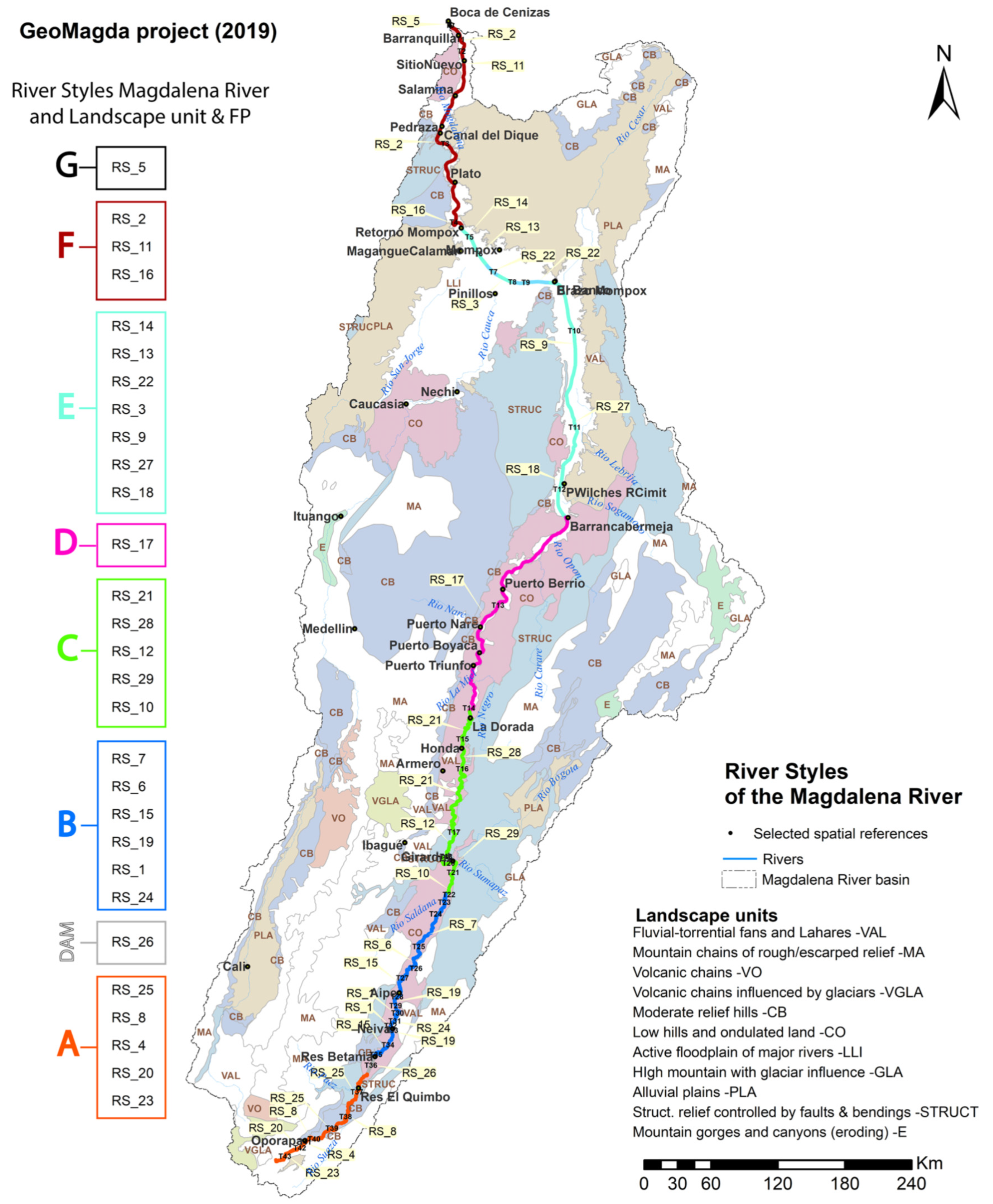
4.1.3. River Styles at the Basin Scale
4.1.4. River Behavior at the Basin Scale
4.1.5. Why Anabranching?
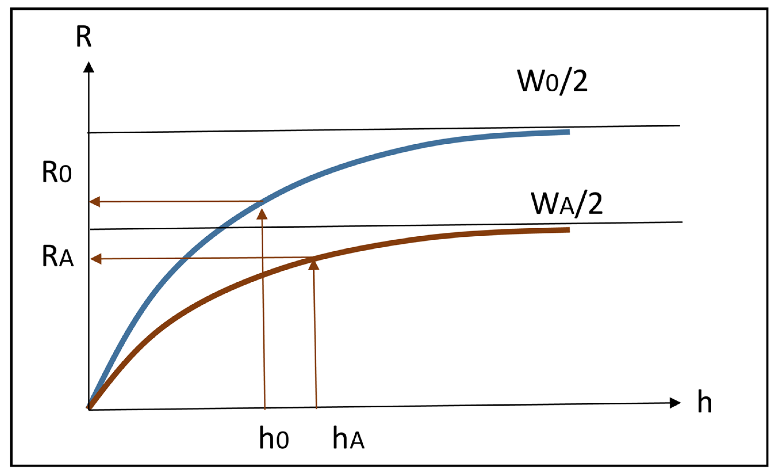
- For relatively frequent, low to moderate flowrates (including bankfull), and relatively low to moderate (but, on average, the largest fraction of the yearly input) coarse solid load input from upstream and local catchment (from fans, laminar erosion, etc.), the anabranch channels just carry the incoming bedload (plus the suspended load), with no overflow nor significant deposition or erosion;
- For infrequent, very high flowrates and associated very high solid input (from landslides, mass block failure, avalanches, debris flows, gully erosion of valley slopes and sub catchments)—the anabranching configuration displays a total hydraulic and bedload transport capacity lower than that of a wider, single channel configuration with similar slope. Therefore, a large part of overbank flow occurs on the floodplain, in a corridor along the main channel (“lit majeur”) with frequent deposition of coarse suspended material along banks (and associated accretion of levees), together with deposition of finer sediments in farther zones of the floodplain;
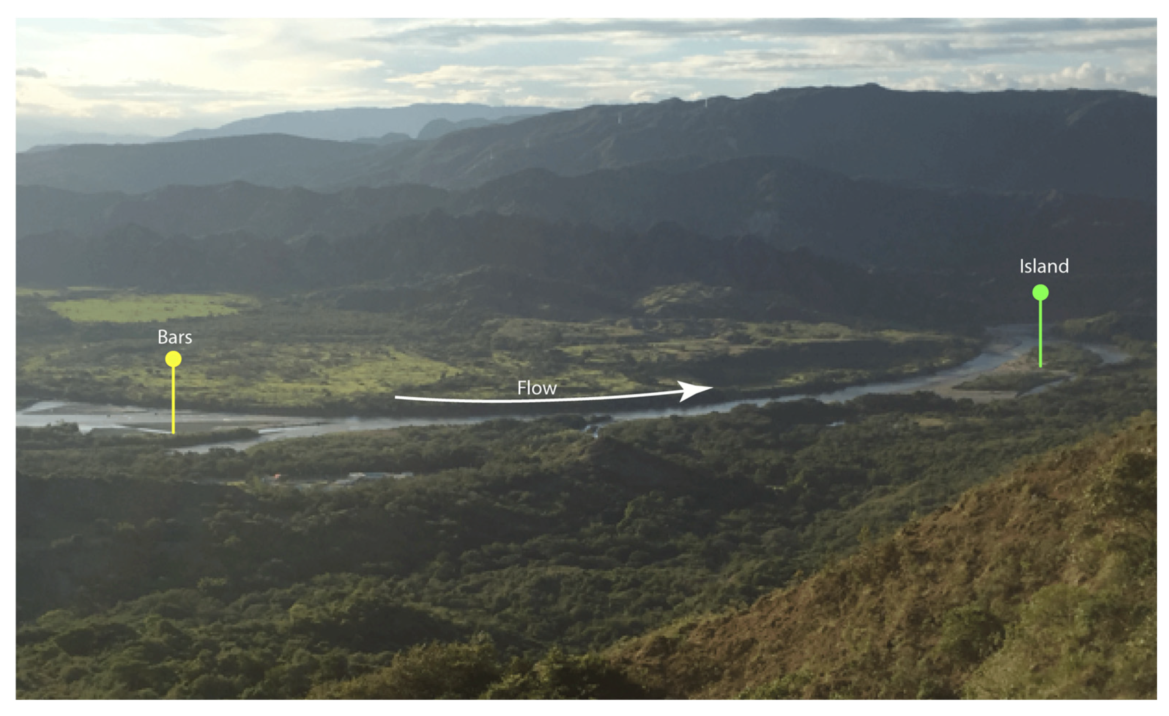
- The tendency to assume a multibranch configuration originates in the waning stage of these high floods, when important quantities of the coarser fraction of solids are deposited, so contributing to the formation of bars and islands. These are rapidly vegetated and, in the following high flood, will trigger the opening of new channels into the floodplain, hence cutting off the immense islands that characterize it;
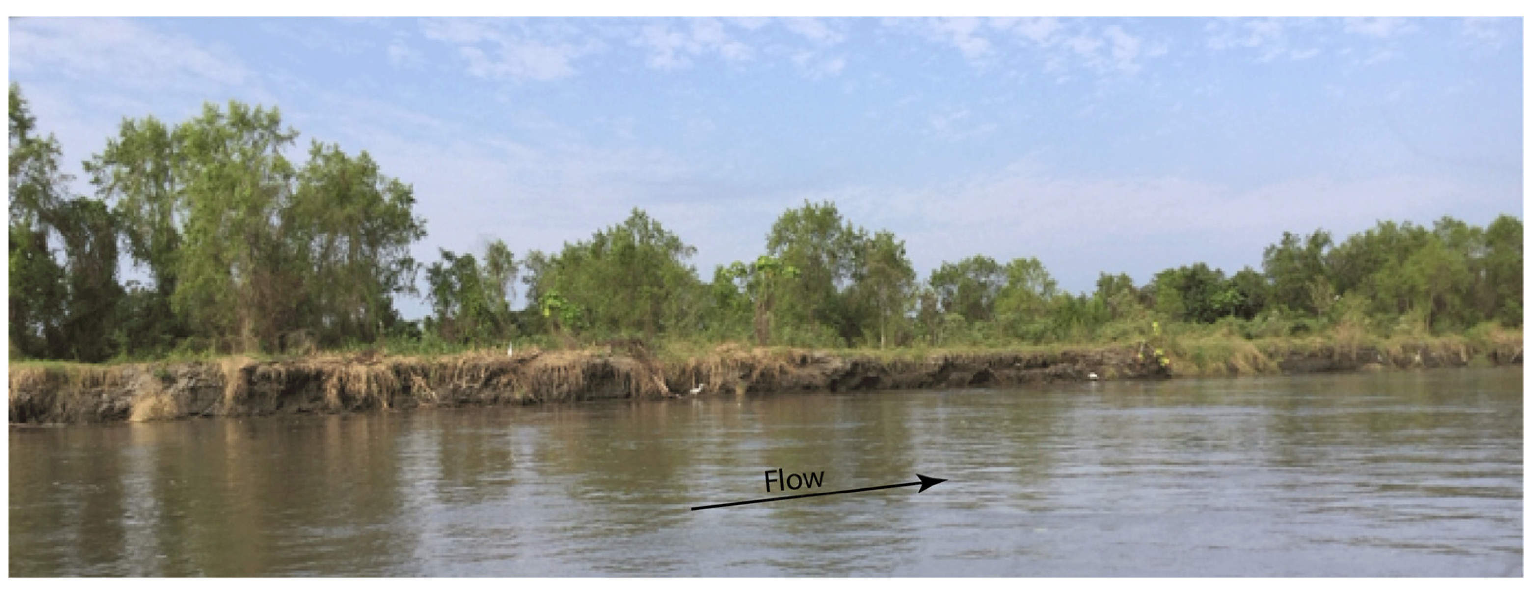
- Within the floodplain itself, several mechanisms contribute to the formation of smaller lateral channels (caños). For instance, the drainage of rainfall waters can concentrate in a slightly lower point of the plain, quickly transforming it in an outlet towards the river so creating the embryo of a new channel. Vice versa, in other points, water in one of the main channels can overtop its levee creating a breech, or a bank failure may occur because of a local landslide possibly triggered by a tree fall: in both cases, a sudden opening of a new channel may occur. At the same time, channels may progressively get clogged by sediments typically at their intake, and a filling process starts from successive flooding by deposition of fine sediments, while new ones are created or enlarged.
4.2. Reach Scale
4.3. Discussion
5. Conclusions
Supplementary Materials
Author Contributions
Funding
Acknowledgments
Conflicts of Interest
Appendix A. Two Channels
References
- Brierley, G.; Fryirs, K. Geomorphology and River Management: Applications of the River Styles Framework; Blackwell Publishing: Malden, MA, USA, 2005. [Google Scholar] [CrossRef]
- Piégay, H.; Arnaud, F.; Belletti, B.; Bertrand, M.; Bizzi, S.; Carbonneau, P.; Dufour, S.; Liébault, F.; Ruiz-Villanueva, V.; Slater, L. Remotely sensed rivers in the Anthropocene: State of the art and prospects. Earth Surf. Process. Landf. 2020, 45, 157–188. [Google Scholar]
- Nardini, A.; Yepez, S.; Rogeliz, C. Caracterización Geomorfológica River Styles en la Cuenca del rio Magdalena: Caso estudio Magdalena y caja de Herramientas Para la Aplicación Automatizada a la Cuenca. GeoMagda ToolBOX; The Nature Conservancy: Bogotá, Colombia, 2019; Available online: https://www.researchgate.net/publication/338585128_Manual_GeoMAGDA (accessed on 1 February 2020).
- Brierley, G.; Fryirs, K.; Cook, N.; Outhet, D.; Raine, A.; Parsons, L.; Healey, M. Geomorphology in action: Linking policy with on-the-ground actions through applications of the River Styles framework. Appl. Geogr. 2011, 31, 1132–1143. [Google Scholar] [CrossRef]
- Brierley, G.; Fryirs, K.; dos Santos Marçal, M.; Lima, R. The use of the River Styles Framework as a tool to ‘work with nature’in managing rivers in Brazil: Examples from the Macaé Catchment. J. Rev. Bras. Geomorfol. 2019, 20. [Google Scholar] [CrossRef] [Green Version]
- Fryirs, K.A.; Brierley, G.J. What’s in a name? A naming convention for geomorphic river types using the River Styles Framework. PLoS ONE 2018, 13, e0201909. [Google Scholar] [CrossRef] [PubMed] [Green Version]
- Kleinhans, M.G.; van den Berg, J.H. River channel and bar patterns explained and predicted by an empirical and a physics-based method. Earth Surf. Process. Landf. 2011, 36, 721–738. [Google Scholar] [CrossRef]
- Piégay, H.; Ruffinoni, C.; Citterio, A.; Bourgery, C.; Caillebote, P. Guide Technique n° 1: La Gestion des Boisements de Rivieres,. Bassin Rhone Mediterranee Corse (FR). Fascicule 1: Dynamique et Fonctions de la Ripisylve. 1998. Available online: https://www.google.com.hk/url?sa=t&rct=j&q=&esrc=s&source=web&cd=1&ved=2ahUKEwiP6cGF2e7oAhUGVpQKHTV7Df0QFjAAegQIAhAB&url=http%3A%2F%2Fdoc-oai.eaurmc.fr%2Fcindocoai%2Fdownload%2F87%2F1%2Fguide-tech-1-f1.pdf_2031Ko&usg=AOvVaw3jnV4GmBh793FyOklrBoKR (accessed on 17 April 2020).
- Nardini, A.; Yepez, S.; Mazzorana, B.; Ulloa, H.; Bejarano, M.D.; Laraque, A. Geomorphic river characterization: A systematic, automated approach for river segmentation with case studies on the Magdalena River (Colombia) and on the Baker River (Chile). Water 2020. (submitted). [Google Scholar]
- Lewin, J.; Ashworth, P.J. Defining large river channel patterns: Alluvial exchange and plurality. Geomorphology 2014, 215, 83–98. [Google Scholar] [CrossRef]
- UTMMC. Strategic Plan for Magdalena-Cauca Macrobasin: Unión Temporal Macrocuencas Magdalena–Cauca y Caribe for Colombian Ministry of Environment; Ministry of Environment: Bogotá, Colombia, 2014.
- IEA. World energy outlook 2014; International Energy Agency: Paris, France, 2014. [Google Scholar]
- Zapata, J.P.; Diaz, J.; Garzonferreira, J.; Garcia, C. Fluvial fluxes into the Caribbean Sea and their impact on coastal ecosystems: The Magdalena River, Colombia. Glob. Planet. Chang. 2006, 50, 33–49. [Google Scholar]
- IDEAM. 2a Comunicación Nacional ante la Convención Marco de las Naciones Unidas Sobre el Cambio Climático (2nd National Communication for the un Convention on Climate Change); Ministerio del Medio Ambiente & PNUD, IDEAM (Instituto de Hidrología, Meteorología y Estudios Ambientales): Bogotá, Colombia, 2010. [Google Scholar]
- Restrepo, J.D. Los Sedimentos del río Magdalena: Reflejo de la Crisis Ambiental; Universidad Eafit: Medellín, Colombia, 2005. [Google Scholar]
- Restrepo, J.D.; Syvitski, J.P. Assessing the effect of natural controls and land use change on sediment yield in a major Andean river: The Magdalena drainage basin, Colombia. Ambio A J. Hum. Environ. 2006, 35, 65–74. [Google Scholar] [CrossRef]
- Alvarez, S.; Jessick, A.M.; Palacio, J.A.; Kolok, A.S. Methylmercury concentrations in six fish species from two Colombian rivers. Bull. Environ. Contam. Toxicol. 2012, 88, 65–68. [Google Scholar] [CrossRef]
- Olivero-Verbel, J.; Johnson-Restrepo, B.; Mendoza-Marín, C.; Paz-Martinez, R.; Olivero-Verbel, R. Mercury in the aquatic environment of the village of Caimito at the Mojana region, north of Colombia. Water Air Soil Pollut. 2004, 159, 409–420. [Google Scholar] [CrossRef]
- DNP. Estudio del Sector Energía Eléctrica: Inventario de los recursos Hidroeléctricos; Fondo Nacional de Proyectos de Desarrollo FONADE, Interconexión Eléctrica ISA, Sociedad Alemana de Cooperación Técnica GTZ.: Bogotá, Colombia, 1979. [Google Scholar]
- Nardini, A.; Idarraga, F. A Qualitative Hydro-Geomorphic Prediction of the Destiny of the Mojana Region (Magdalena-Cauca Basin, Colombia), to Inform Large Scale Decision Making. Resources 2016, 5, 22. [Google Scholar] [CrossRef] [Green Version]
- Grill, G.; Lehner, B.; Thieme, M.; Geenen, B.; Tickner, D.; Antonelli, F.; Babu, S.; Borrelli, P.; Cheng, L.; Crochetiere, H. Mapping the world’s free-flowing rivers. Nature 2019, 569, 215. [Google Scholar] [CrossRef] [PubMed]
- Roux, C.; Alber, A.; Bertrand, M.; Vaudor, L.; Piégay, H. “FluvialCorridor”: A new ArcGIS toolbox package for multiscale riverscape exploration. Geomorphology 2015, 242, 29–37. [Google Scholar] [CrossRef]
- Nardini, A. River Planform identification through an automatic logical-heuristic algorithm. J. South Am. Earth Sci. 2020. (submitted). [Google Scholar]
- Nardini, A.; Yepez, S.; Bejarano, M.D. Improvements in Computer-Aided Tools to Support Geomorphic River Styles Analysis. Geosciences 2020. (submitted). [Google Scholar]
- IDEAM. Geomorfología y Susceptibilidad a la Inundación del valle Fluvial del Magdalena. Sector Barrancabermeja -Bocas de Cenizas; Subdirección de Geomorfología y Suelos, IDEAM: Bogotá, Colombia, 2001. [Google Scholar]
- Ordoñez, J.I.; Deeb, A. Caracteristicas sedimentologicas del lahar del río Guali del 13 de noviembre de 1985 y sus efectos sobre el río Magdalena, Colombia. In Proceedings of the XII Congreso LatinoAmericano de Hidraulica –IAHR, Santiago de Chile, Chile, 25–30 August 2014. [Google Scholar]
- Martínez, J.I.; López, E. El sistema fluvial del Magdalena durante el Plioceno–Cuaternario: Contexto tectónico y escenario paleoclimático. Los Sedimentos del Río Magdalena Reflejo de la Crisis Ambiental 2005, 1, 101–112. [Google Scholar]
- Ortega, M.A. Río Magdalena, Navegación Marítima y Fluvial (1986–2008); Universidad del Norte: Barranquilla, Colombia, 2008. [Google Scholar]
- Fondo_de_Adaptación. Valoración Integral de la Biodiversidad y Los Servicios Ecosistémicos en el Núcleo de Once Municipios de la Región de La Mojana (Integrated Evaluation of Biodiversity and Ecosystem Services in the Área of Eleven Municipalities within the Mojana Región; Fondo de Adaptación: Bogota, Colombia, 2015. [Google Scholar]
- Brierley, G.; Fryirs, K.; Cullum, C.; Tadaki, M.; Huang, H.Q.; Blue, B. Reading the landscape: Integrating the theory and practice of geomorphology to develop place-based understandings of river systems. Progress Phys. Geogr. 2013, 37, 601–621. [Google Scholar] [CrossRef]
- Yepez, S.P.; Laraque, A.; Gualtieri, C.; Christophoul, F.; Marchan, C.; Castellanos, B.; Azocar, J.M.; Lopez, J.L.; Alfonso, J.J. Morphodynamic change analysis of bedforms in the Lower Orinoco River, Venezuela. Proc. Int. Assoc. Hydrol. Sci. 2018, 377, 41–50. [Google Scholar] [CrossRef] [Green Version]
- Jiménez-Segura, L.F.; Palacio, J.; Leite, R. River flooding and reproduction of migratory fish species in the Magdalena River basin, Colombia. Ecol. Freshw. Fish 2010, 19, 178–186. [Google Scholar] [CrossRef]
- López-Casas, S.; Jiménez-Segura, L.; Agostinho, A.; Pérez, C. Potamodromous migrations in the Magdalena River basin: Bimodal reproductive patterns in neotropical rivers. J. Fish Biol. 2016, 89, 157–171. [Google Scholar] [CrossRef]
- Hammen, V.D. Fluctuaciones holocenicas del nivel de inundaciones en la cuenca del bajo Magdalena-Cauca-San Jorge (Colombia). Geol. Norandina. 1986 10, 11–17.
- HIMAT. Proyecto Cuenca Magdalena-Cauca; Convenio Colombo-Holandés: Bogota, Colombia, 1977. [Google Scholar]
- Martínez, A. Subsidencia y geomorfología de la depresión inundable del río Magdalena. Actas Primer seminario sobre el Cuaternario de Colombia. Rev. CIAF 1981, 6, 319–328. [Google Scholar]
- Smith, D.G. Anastomosing river deposits, sedimentation rates and basin subsidence, Magdalena River, northwestern Colombia, South America. Sediment. Geol. 1986, 46, 177–196. [Google Scholar] [CrossRef]
- Alvarado, M. Personal Interview; Universidad de La Guajira: Riohacha, Colombia, 2020. [Google Scholar]
- Jansen, J.D.; Nanson, G.C. Anabranching and maximum flow efficiency in Magela Creek, northern Australia. Water Resour. Res. 2004, 40. [Google Scholar] [CrossRef] [Green Version]
- Abbado, D.; Slingerland, R.; Smith, N.D. Origin of anastomosis in the upper Columbia River, British Columbia, Canada. In Fluvial Sedimentology VII; Blackwell Oxford: Oxford, UK, 2005; Volume 35, pp. 3–15. [Google Scholar]
- Latrubesse, E.M. Patterns of anabranching channels: The ultimate end-member adjustment of mega rivers. Geomorphology 2008, 101, 130–145. [Google Scholar] [CrossRef]
- Liébault, F.; Lallias-Tacon, S.; Cassel, M.; Talaska, N. Long profile responses of alpine braided rivers in SE France. River Res. Appl. 2013, 29, 1253–1266. [Google Scholar] [CrossRef]
- Dalla Mura, M.; Prasad, S.; Pacifici, F.; Gamba, P.; Chanussot, J.; Benediktsson, J.A. Challenges and opportunities of multimodality and data fusion in remote sensing. Proc. IEEE 2015, 103, 1585–1601. [Google Scholar] [CrossRef] [Green Version]
- Monegaglia, F.; Zolezzi, G.; Güneralp, I.; Henshaw, A.J.; Tubino, M. Software Automated extraction of meandering river morphodynamics from multitemporal remotely sensed data. Environ. Model. 2018, 105, 171–186. [Google Scholar] [CrossRef]
- Demarchi, L.; Bizzi, S.; Piégay, H. Hierarchical Object-Based Mapping of Riverscape Units and in-Stream Mesohabitats Using LiDAR and VHR Imagery. Remote Sens. 2016, 8, 97. [Google Scholar] [CrossRef] [Green Version]
- Henderson, F.M. Open Channel Flow; Macmillan: New York, NY, USA, 1966. [Google Scholar]
- Schmidt, J.C.; Wilcock, P.R. Metrics for assessing the downstream effects of dams. Water Resour. Res. 2008, 44. [Google Scholar] [CrossRef] [Green Version]
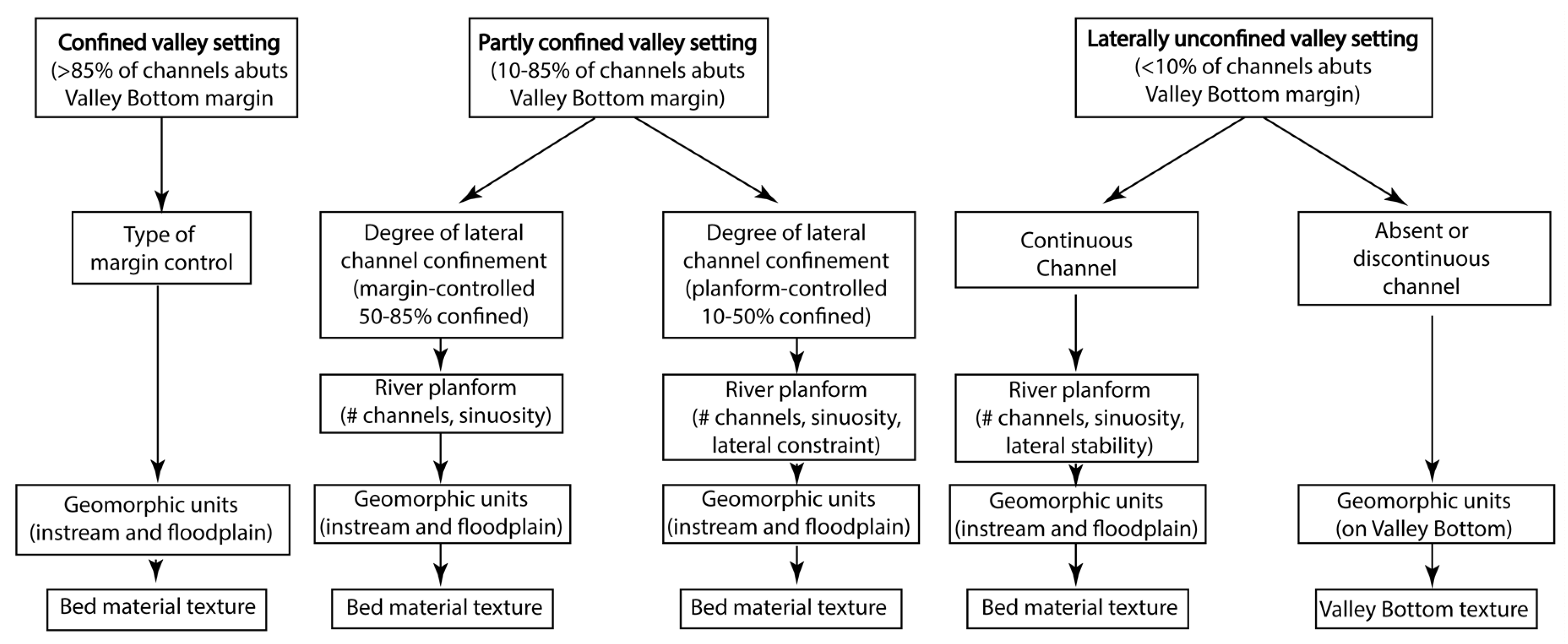
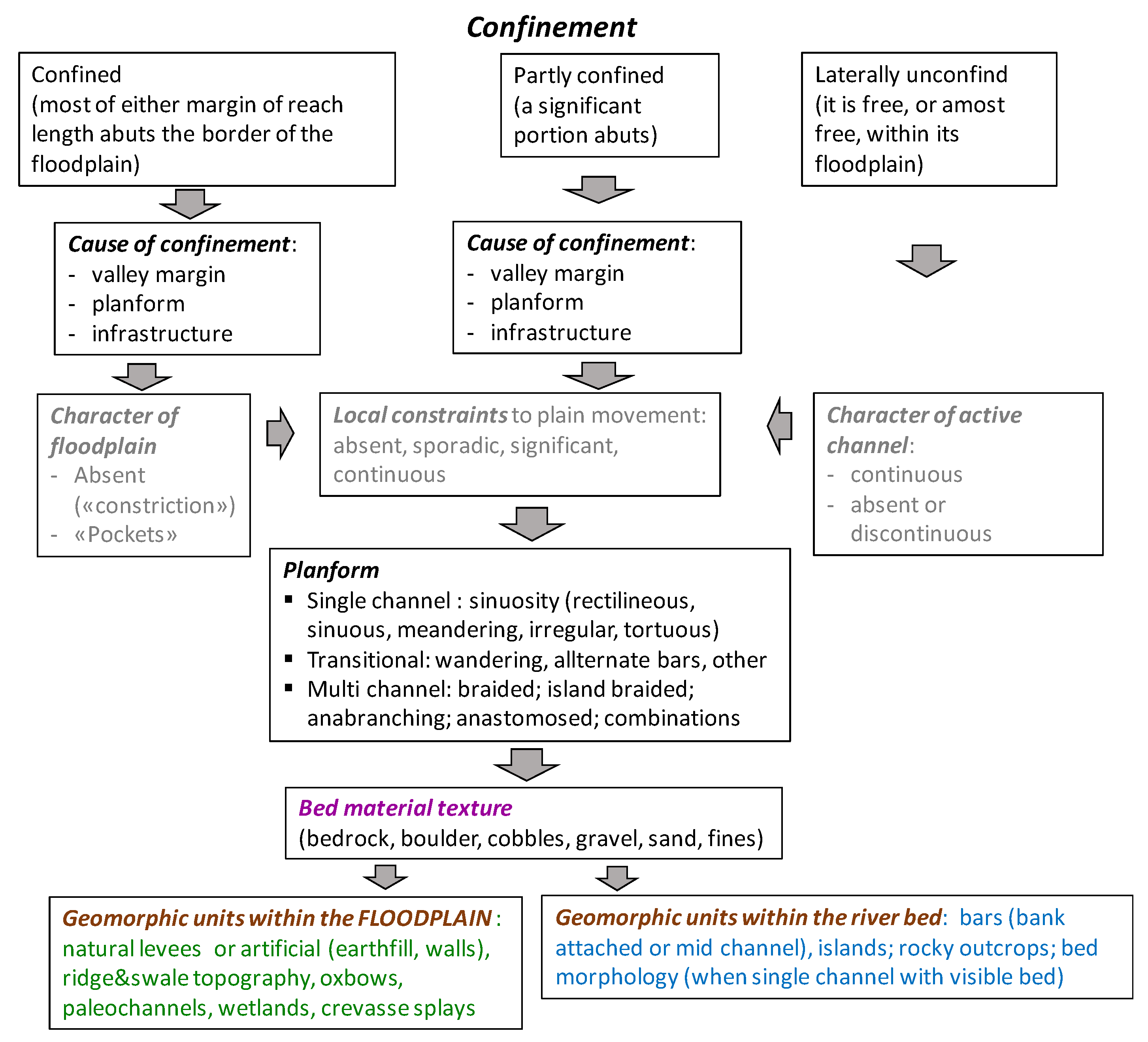
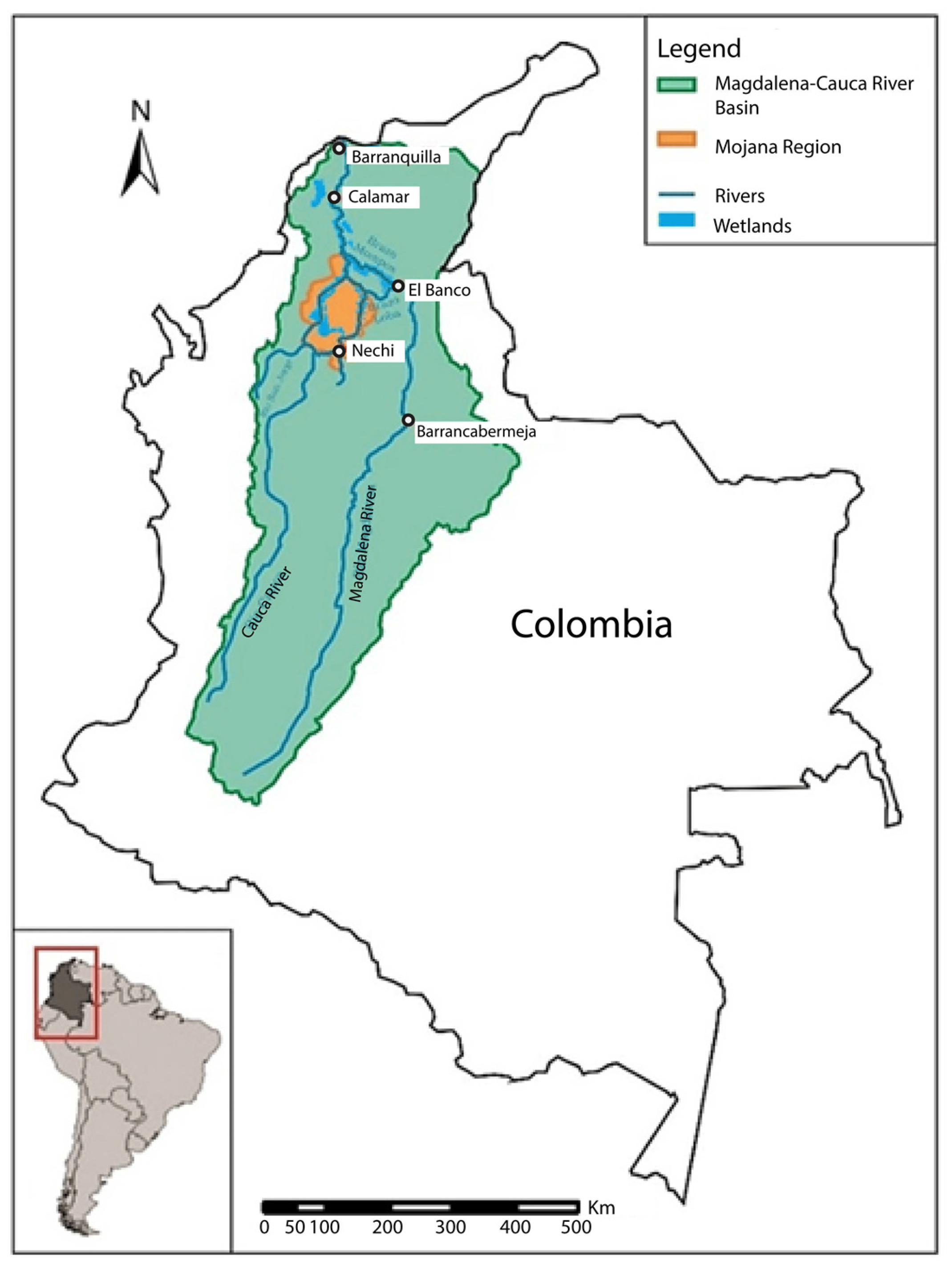



| Reach | RS Main | RS Complete | Distance km | Length km | Confinement | Cause of Conf. | Planform Type | Bed mat. Text. | Levees | Ridge&Swales | Wetlands | Oxbows | Paleochan. | Water Surface | Islands | LAT Bars | MED Bars |
|---|---|---|---|---|---|---|---|---|---|---|---|---|---|---|---|---|---|
| T0 | RS_5 | RS_5_1_1 | 1429.0 | 6.58 | Confined | valley flanks | sinuous | sand | significant | absent | complete | absent | absent | plane surface | absent | absent | absent |
| T1 | RS_2 | RS_2_2_1 | 1403.7 | 25.33 | Partly confined | planforms | "swallowing" | sand | significant | significant | complete | absent | absent | ripples | significant | absent | absent |
| T2 | RS_11 | RS_11_1_1 | 1383.3 | 20.36 | Lat. unconfined | - | straight | sand | complete | occasional | complete | absent | prevailing | ripples | occasional | absent | absent |
| T3 | RS_2 | RS_2_1_1 | 1232.5 | 150.82 | Partly confined | planforms | "swallowing" | sand | complete | occasional | complete | occasional | significant | ripples | prevailing | absent | absent |
| T4 | RS_16 | RS_16_1_1 | 1206.5 | 26.04 | Partly confined | planforms | meandering | sand | complete | complete | complete | complete | complete | ripples | complete | absent | absent |
| T5 | RS_14 | RS_14_1_1 | 1186.6 | 19.91 | Lat. unconfined | - | anabranching & meandering | sand | complete | prevailing | complete | complete | complete | ripples | complete | absent | absent |
| T6 | RS_13 | RS_13_1_1 | 1164.0 | 22.59 | Partly confined | planforms | anastomosed & sinuous | sand | complete | absent | complete | complete | complete | ripples | complete | absent | absent |
| T7 | RS_22 | RS_22_1_1 | 1149.8 | 14.20 | Lat. unconfined | - | anastomosed & sinuous | sand | complete | absent | complete | complete | complete | streamed | complete | absent | absent |
| T8 | RS_3 | RS_3_1_1 | 1135.5 | 14.28 | Lat. unconfined | - | anastomosed & meandering | sand | complete | absent | complete | complete | complete | plane surface | complete | absent | absent |
| T9 | RS_22 | RS_22_1_2 | 1102.3 | 33.18 | Lat. unconfined | - | anastomosed & sinuous | sand | complete | absent | complete | complete | complete | plane surface | complete | absent | absent |
| T10 | RS_9 | RS_9_1_1 | 979.5 | 122.82 | Lat. unconfined | - | anastomosed & island braided | sand | complete | absent | complete | significant | complete | ripples | complete | absent | occasional |
| T11 | RS_27 | RS_27_1_1 | 957.6 | 21.94 | Lat. unconfined | - | island braided | sand | complete | absent | complete | absent | prevailing | ripples | complete | absent | significant |
| T12 | RS_18 | RS_18_1_1 | 872.6 | 85.00 | Lat. unconfined | - | island braided & anabranching | sand | prevailing | absent | complete | absent | significant | ripples | complete | absent | occasional |
| T13 | RS_17 | RS_17_1_1 | 634.0 | 238.52 | Partly confined | planforms | island braided | sand | absent | absent | occasional | absent | significant | ripples | prevailing | occasional | significant |
| T14 | RS_21 | RS_21_2_1 | 594.8 | 39.24 | Confined | planforms | "swallowing" | sand | absent | absent | absent | significant | occasional | ripples | significant | prevailing | significant |
| T15 | RS_28 | RS_28_1_1 | 570.8 | 23.98 | Confined | planforms | straight | boulders&cobbles | absent | absent | absent | absent | significant | ripples | occasional | absent | absent |
| T16 | RS_21 | RS_21_1_1 | 501.5 | 69.33 | Confined | planforms | "swallowing" | sand | absent | occasional | absent | absent | complete | ripples | significant | occasional | occasional |
| T17 | RS_12 | RS_12_1_1 | 467.2 | 34.28 | Confined | planforms | straight | sand | absent | absent | absent | absent | significant | plane surface | absent | absent | absent |
| T18 | RS_12 | RS_12_2_1 | 456.6 | 10.62 | Confined | planforms | straight | sand | absent | absent | absent | absent | absent | streamed | absent | absent | absent |
| T19 | RS_29 | RS_29_2_2 | 447.7 | 8.95 | Confined | planforms | straight | bedrock | absent | absent | absent | absent | absent | streamed | absent | absent | absent |
| T20 | RS_29 | RS_29_2_1 | 436.0 | 11.61 | Confined | planforms | straight | bedrock | absent | absent | absent | absent | absent | corrugated | absent | absent | absent |
| T21 | RS_29 | RS_29_1_1 | 410.7 | 25.39 | Confined | planforms | straight | bedrock | absent | absent | absent | absent | significant | ripples | absent | absent | absent |
| T22 | RS_10 | RS_10_1_1 | 399.1 | 11.55 | Confined | planforms | straight | sand&gravel | absent | absent | absent | absent | complete | ripples | absent | absent | absent |
| T23 | RS_7 | RS_7_1_3 | 380.9 | 18.23 | Partly confined | planforms | anabranching | sand&gravel | absent | absent | absent | absent | complete | not detectable | significant | absent | absent |
| T24 | RS_7 | RS_7_1_1 | 349.7 | 31.15 | Partly confined | planforms | anabranching | sand&gravel | absent | absent | absent | absent | complete | ripples | complete | absent | absent |
| T25 | RS_7 | RS_7_1_2 | 319.2 | 30.51 | Partly confined | planforms | anabranching | sand&gravel | absent | absent | absent | absent | complete | not detectable | complete | absent | absent |
| T26 | RS_6 | RS_6_1_1 | 305.5 | 13.73 | Confined | valley flanks | straight | cobbles | absent | absent | absent | absent | complete | not detectable | occasional | absent | absent |
| T27 | RS_15 | RS_15_1_1 | 271.8 | 33.68 | Partly confined | planforms | "swallowing" | cobbles | absent | absent | absent | absent | complete | streamed | significant | absent | absent |
| T28 | RS_19 | RS_19_3_1 | 258.9 | 12.92 | Partly confined | planforms | anabranching | cobbles | absent | absent | absent | absent | prevailing | streamed | prevailing | absent | absent |
| T29 | RS_19 | RS_19_2_1 | 253.4 | 5.51 | Partly confined | planforms | anabranching | cobbles | absent | absent | absent | absent | absent | plane surface | complete | absent | absent |
| T30 | RS_1 | RS_1_2_1 | 240.4 | 13.03 | Partly confined | planforms | sinuous | cobbles | absent | absent | absent | absent | occasional | plane surface | significant | absent | absent |
| T31 | RS_24 | RS_24_1_1 | 232.8 | 7.56 | Confined | planforms | "swallowing" | cobbles | absent | absent | absent | absent | complete | plane surface | prevailing | absent | absent |
| T32 | RS_1 | RS_1_1_1 | 227.8 | 5.03 | Partly confined | planforms | sinuous | cobbles | absent | absent | absent | absent | complete | plane surface | complete | absent | absent |
| T33 | RS_19 | RS_19_1_1 | 223.0 | 4.79 | Partly confined | planforms | anabranching | cobbles | absent | absent | absent | absent | complete | plane surface | complete | absent | absent |
| T34 | RS_15 | RS_15_2_1 | 197.9 | 25.10 | Partly confined | planforms | "swallowing" | cobbles | absent | absent | absent | absent | significant | plane surface | significant | absent | absent |
| T35 | RS_15 | RS_15_3_1 | 187.1 | 10.80 | Partly confined | planforms | "swallowing" | cobbles | absent | absent | absent | absent | absent | streamed | absent | absent | absent |
| T36 | RS_26 | RS_26_1_1 | 169.9 | 17.13 | reservoir | ||||||||||||
| T37 | RS_25 | RS_25_2_1 | 118.0 | 51.89 | Partly confined | planforms | wandering | cobbles | absent | absent | absent | absent | occasional | not detectable | occasional | absent | absent |
| T38 | RS_8 | RS_8_2_1 | 97.1 | 20.92 | Partly confined | valley flanks | sinuous | cobbles | absent | absent | absent | absent | occasional | pool & riffles | occasional | absent | absent |
| T39 | RS_25 | RS_25_1_1 | 64.5 | 32.63 | Partly confined | planforms | wandering | cobbles | absent | absent | absent | absent | significant | corrugated | occasional | absent | absent |
| T40 | RS_8 | RS_8_1_1 | 46.8 | 17.70 | Partly confined | valley flanks | wandering | cobbles | absent | absent | absent | absent | absent | not detectable | absent | absent | absent |
| T41 | RS_4 | RS_4_1_1 | 41.1 | 5.67 | Confined | valley flanks | wandering | cobbles | absent | absent | absent | absent | absent | rapids | absent | absent | absent |
| T42 | RS_20 | RS_20_1_1 | 27.9 | 13.18 | Confined | planforms | sinuous | cobbles | absent | absent | absent | absent | absent | pool & riffles | absent | absent | absent |
| T43 | RS_23 | RS_23_1_1 | 0.0 | 27.93 | Partly confined | valley flanks | sinuous | cobbles | absent | absent | absent | absent | absent | rapids | absent | absent | absent |
| Confinement | % | Cause of Confinement | % | N. Channels | % | Bed Material | % | |
| Lat. unconfined | 23.4 | Valley slopes | 6.5 | Mono | 17.6 | Bedrock | 3.2 | |
| Partly confined | 56.8 | Planforms | 70.1 | Transitional | 34.2 | Boulders&Cobbles | 1.7 | |
| confined | 19.8 | Infrastructures | 0 | Multi Chann. | 47.1 | Cobbles | 21.3 | |
| 100 | none | 23.4 | (reservoir) | 1.1 | Sand&gravel | 6.4 | ||
| 100 | 100 | Sand | 67.4 | |||||
| 100 | ||||||||
| Planform | % | Water surface type | % | |||||
| Straight | 11.3 | Rapids | 2.4 | |||||
| Sinuous | 4.6 | Corrugated | 3.1 | |||||
| Meandering | 1.8 | Pool & riffle | 2.4 | |||||
| Wandering | 9.1 | Streamed | 6.4 | |||||
| Swallowing | 25.5 | Rippled | 65.8 | |||||
| Anabraching | 7.3 | Plane surface | 10.5 | |||||
| Anabranching & Meandering | 1.4 | Not detectable | 9.4 | |||||
| Island braided | 18.4 | 100 | ||||||
| Island braided & Anabranching | 6.0 | |||||||
| Anastomosed & sinuous | 4.9 | |||||||
| Anastomosed & meandering | 1.0 | |||||||
| Anastomosed & island braided | 8.7 | |||||||
| 100 | ||||||||
| % | Ridge &Swales | Nat. Levees | Oxbows | Wetlands | Paleo Ch.ls | Islands | Bars MED | Bars LAT |
| Absent | 78 | 60.3 | 68.8 | 43.5 | 10.1 | 14.8 | 59.3 | 75.5 |
| Occasional | 17 | 0 | 10.6 | 16.8 | 8.8 | 11.5 | 19.5 | 21.7 |
| Significant | 1.8 | 2.2 | 11.4 | 0 | 43.5 | 14.0 | 21.2 | 0 |
| Prevailing | 1.4 | 6.0 | 0 | 0 | 3.9 | 28.9 | 0 | 2.8 |
| Complete | 1.8 | 31.5 | 9.2 | 39.7 | 33.7 | 30.8 | 0 | 0 |
| 100 | 100 | 100 | 100 | 100 | 100 | 100 | 100 | |
| Reach | RS main | D km | Code | Landscape Unit & Floodplain (FP) | Description |
|---|---|---|---|---|---|
| T0 | RS_5 | 1429.0 | G | Low hills & undulated land, moderate to narrow discontinuous FP. | Confined by valley flanks and works; single-thread, sinuous planform, fine sediment texture. Sediment depositional zone within the FP, with a capacity limited, mixed transport regime. |
| T1 | RS_2 | 1403.7 | F | Moderate relief hills, discontinuous FP. | Partly confined, mainly single-thread, with a plethora of planform types, sandy bed texture; highly dynamic; sediment depositional zone within the FP, with capacity limited, mixed regime. |
| T2 | RS_11 | 1383.3 | |||
| T3 | RS_2 | 1232.5 | |||
| T4 | RS_16 | 1206.5 | |||
| T5 | RS_14 | 1186.6 | E | Alluvial plain. | Laterally unconfined, anastomosed with fine sand sediment texture, ubiquitous levees and large wetlands. Sediment depositional zone, with a capacity limited, mixed transport regime. |
| T6 | RS_13 | 1164.0 | |||
| T7 | RS_22 | 1149.8 | |||
| T8 | RS_3 | 1135.5 | |||
| T9 | RS_22 | 1102.3 | |||
| T10 | RS_9 | 979.5 | |||
| T11 | RS_27 | 957.6 | |||
| T12 | RS_18 | 872.6 | |||
| T13 | RS_17 | 634.0 | D | Low hills & undulated land, narrow but continuous FP. | Confined by former alluvial deposits; island braided planform, coarse sediment texture (sand). Sediment transfer zone, with a capacity limited, mixed transport regime. |
| T14 | RS_21 | 594.8 | C | Low hills & undulated land, narrow FP, sometimes missing. | Confined by former alluvial deposits; mainly single-thread (sometimes “swallowing”) planform, coarse sediment texture (mainly sand), but also a bedrock stretch near Girardot. This is a sediment transfer zone, with a capacity limited, bed transport regime. |
| T15 | RS_28 | 570.8 | |||
| T16 | RS_21 | 501.5 | |||
| T17 | RS_12 | 467.2 | |||
| T18 | RS_12 | 456.6 | |||
| T19 | RS_29 | 447.7 | |||
| T20 | RS_29 | 436.0 | |||
| T21 | RS_29 | 410.7 | |||
| T22 | RS_10 | 399.1 | |||
| T23 | RS_7 | 380.9 | B | Low hills & undulated land, narrow FP. | Mainly confined, anabranching, coarse sediment, sediment transfer zone, capacity limited, bed transport regime. |
| T24 | RS_7 | 349.7 | |||
| T25 | RS_7 | 319.2 | |||
| T26 | RS_6 | 305.5 | |||
| T27 | RS_15 | 271.8 | |||
| T28 | RS_19 | 258.9 | |||
| T29 | RS_19 | 253.4 | |||
| T30 | RS_1 | 240.4 | |||
| T31 | RS_24 | 232.8 | |||
| T32 | RS_1 | 227.8 | |||
| T33 | RS_19 | 223.0 | |||
| T34 | RS_15 | 197.9 | |||
| T35 | RS_15 | 187.1 | |||
| T36 | RS_26 | 169.9 | Betania Reservoir | ||
| T37 | RS_25 | 118.0 | A | Mountain/Hilly land, narrow, discontinuous FP. | Fully or partly confined, single-thread, coarse sediment, sediment source zone, supply limited, bed transport regime. |
| T38 | RS_8 | 97.1 | |||
| T39 | RS_25 | 64.5 | |||
| T40 | RS_8 | 46.8 | |||
| T41 | RS_4 | 41.1 | |||
| T42 | RS_20 | 27.9 | |||
| T43 | RS_23 | 0.0 |
© 2020 by the authors. Licensee MDPI, Basel, Switzerland. This article is an open access article distributed under the terms and conditions of the Creative Commons Attribution (CC BY) license (http://creativecommons.org/licenses/by/4.0/).
Share and Cite
Nardini, A.; Yepez, S.; Zuniga, L.; Gualtieri, C.; Bejarano, M.D. A Computer Aided Approach for River Styles—Inspired Characterization of Large Basins: The Magdalena River (Colombia). Water 2020, 12, 1147. https://doi.org/10.3390/w12041147
Nardini A, Yepez S, Zuniga L, Gualtieri C, Bejarano MD. A Computer Aided Approach for River Styles—Inspired Characterization of Large Basins: The Magdalena River (Colombia). Water. 2020; 12(4):1147. https://doi.org/10.3390/w12041147
Chicago/Turabian StyleNardini, Andrea, Santiago Yepez, Lislie Zuniga, Carlo Gualtieri, and Maria Dolores Bejarano. 2020. "A Computer Aided Approach for River Styles—Inspired Characterization of Large Basins: The Magdalena River (Colombia)" Water 12, no. 4: 1147. https://doi.org/10.3390/w12041147
APA StyleNardini, A., Yepez, S., Zuniga, L., Gualtieri, C., & Bejarano, M. D. (2020). A Computer Aided Approach for River Styles—Inspired Characterization of Large Basins: The Magdalena River (Colombia). Water, 12(4), 1147. https://doi.org/10.3390/w12041147


