Revisiting the Statistical Scaling of Annual Discharge Maxima at Daily Resolution with Respect to the Basin Size in the Light of Rainfall Climatology


Abstract
Highlights:
- The statistical scaling of annual discharge maxima with the drainage area A of catchments is revisited in the light of rainfall climatology.
- Neglecting the dependence of annual discharge maxima on rainfall characteristics may lead to diverse findings regarding the observed type of scaling.
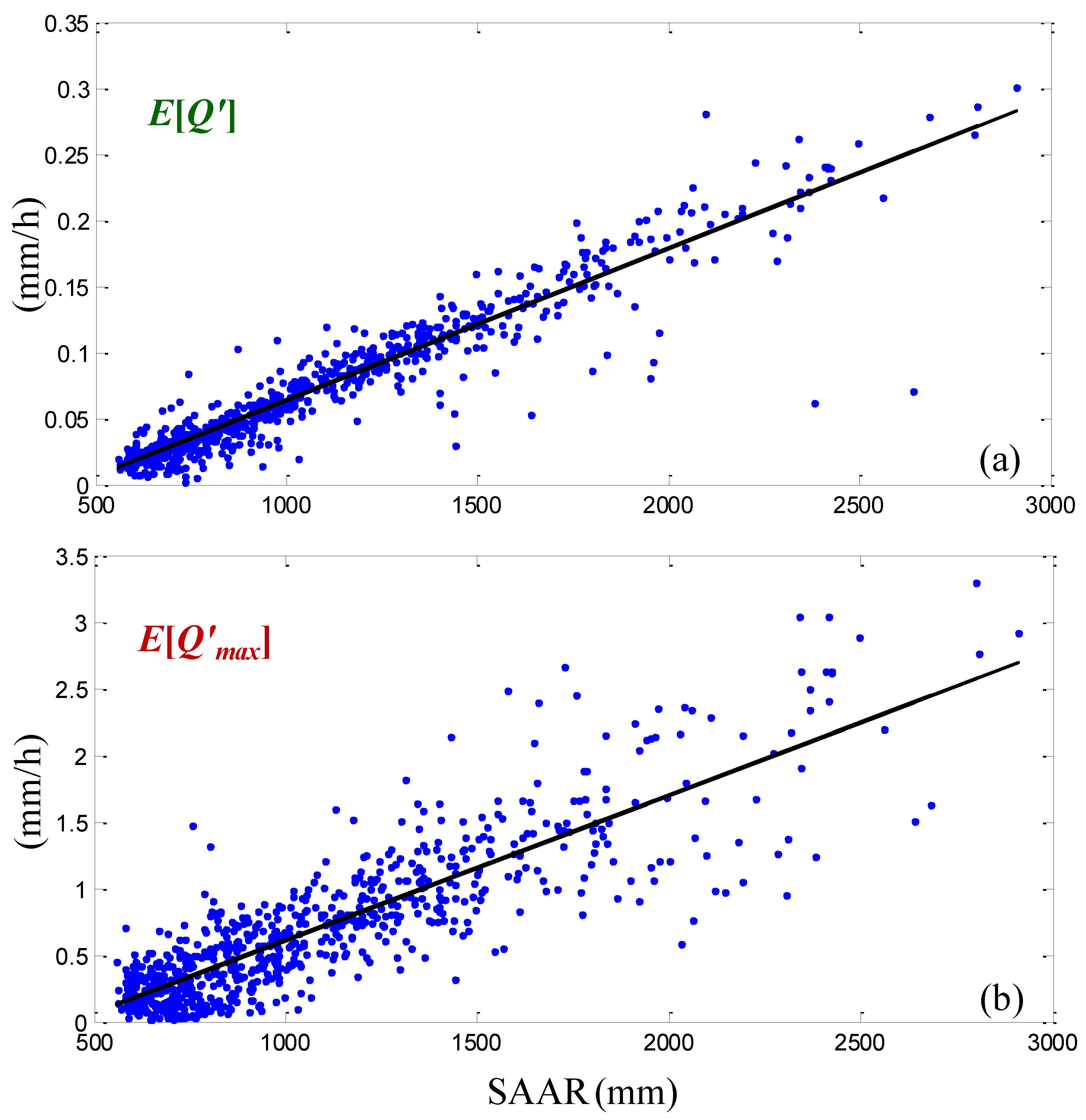
- The multiplicative fluctuations of discharge maxima relative to their corresponding means closely follow the scaling properties of actual rainfields.
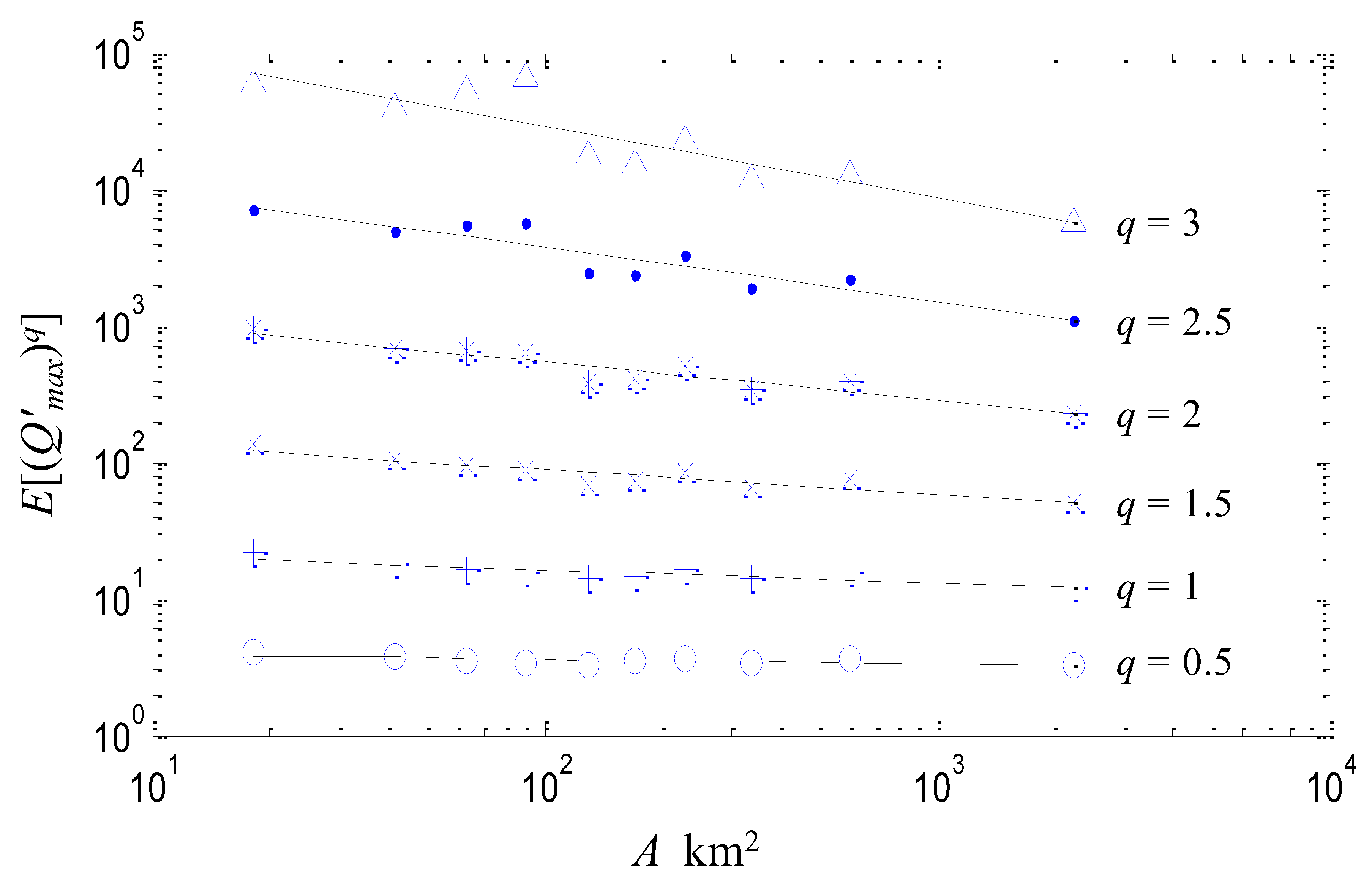
- For spatial scales below approximately 100 km2, where rainfall deviates from multiflactal scale invariance, a break of scaling is also observed for the multiplicative fluctuations.
1. Introduction
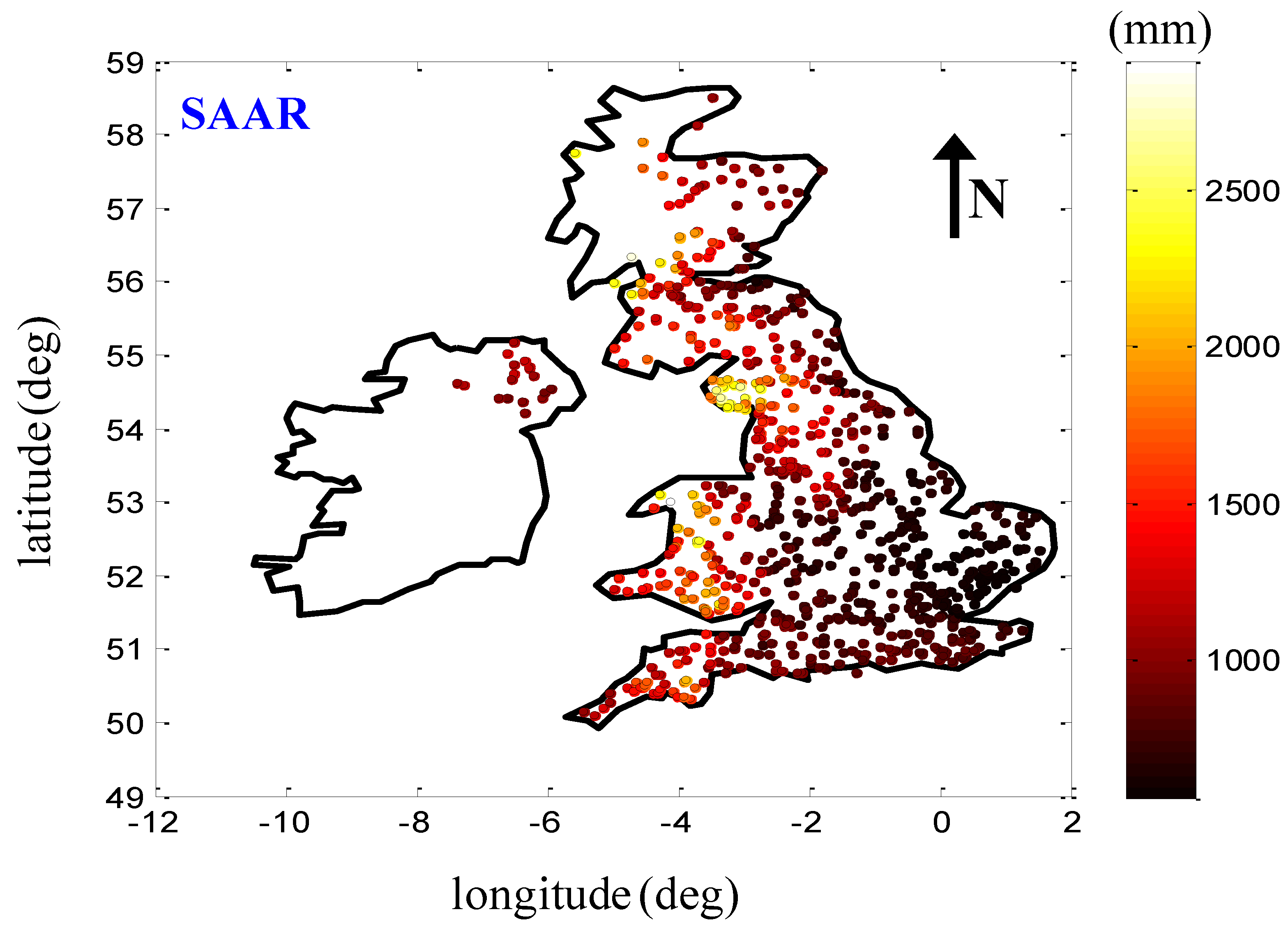
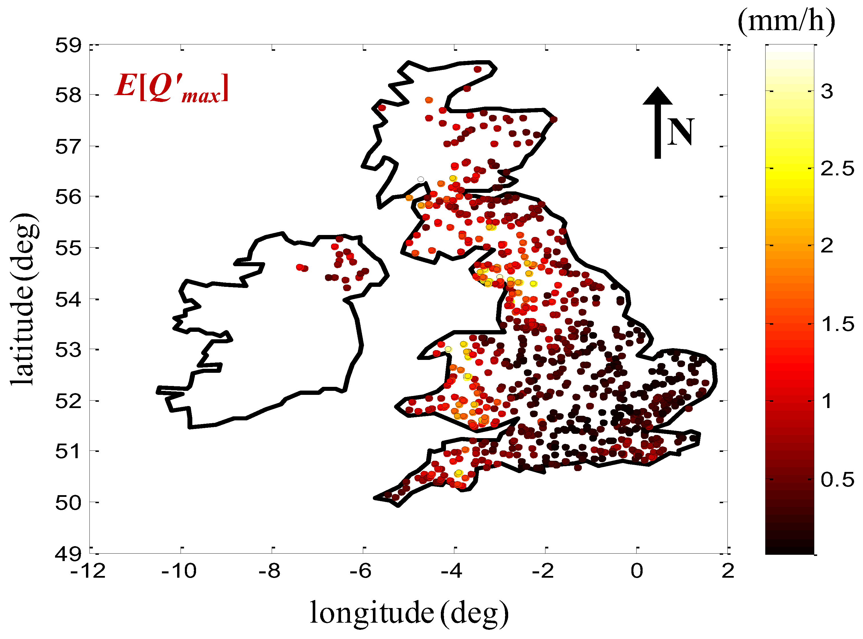
2. Data
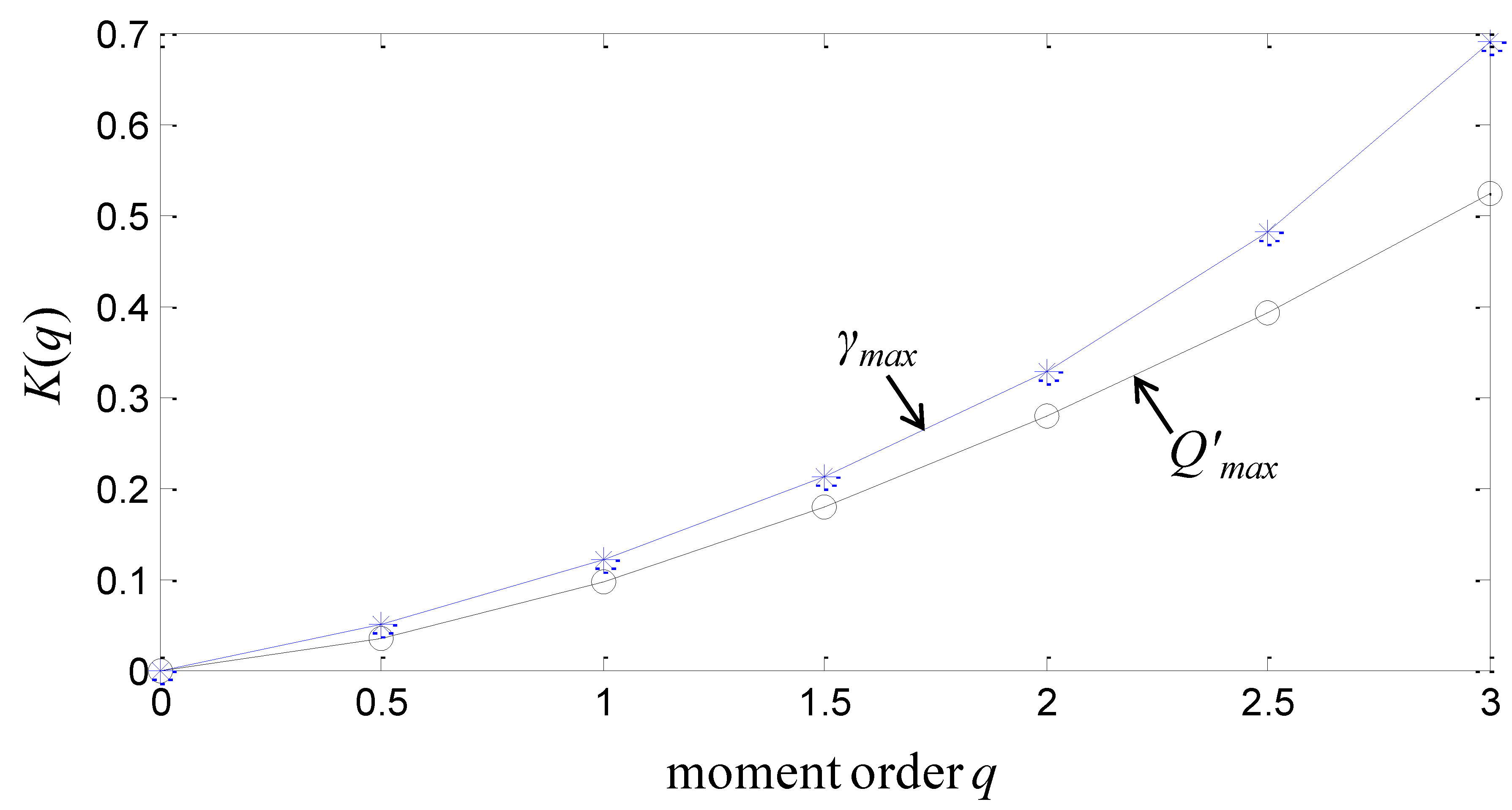
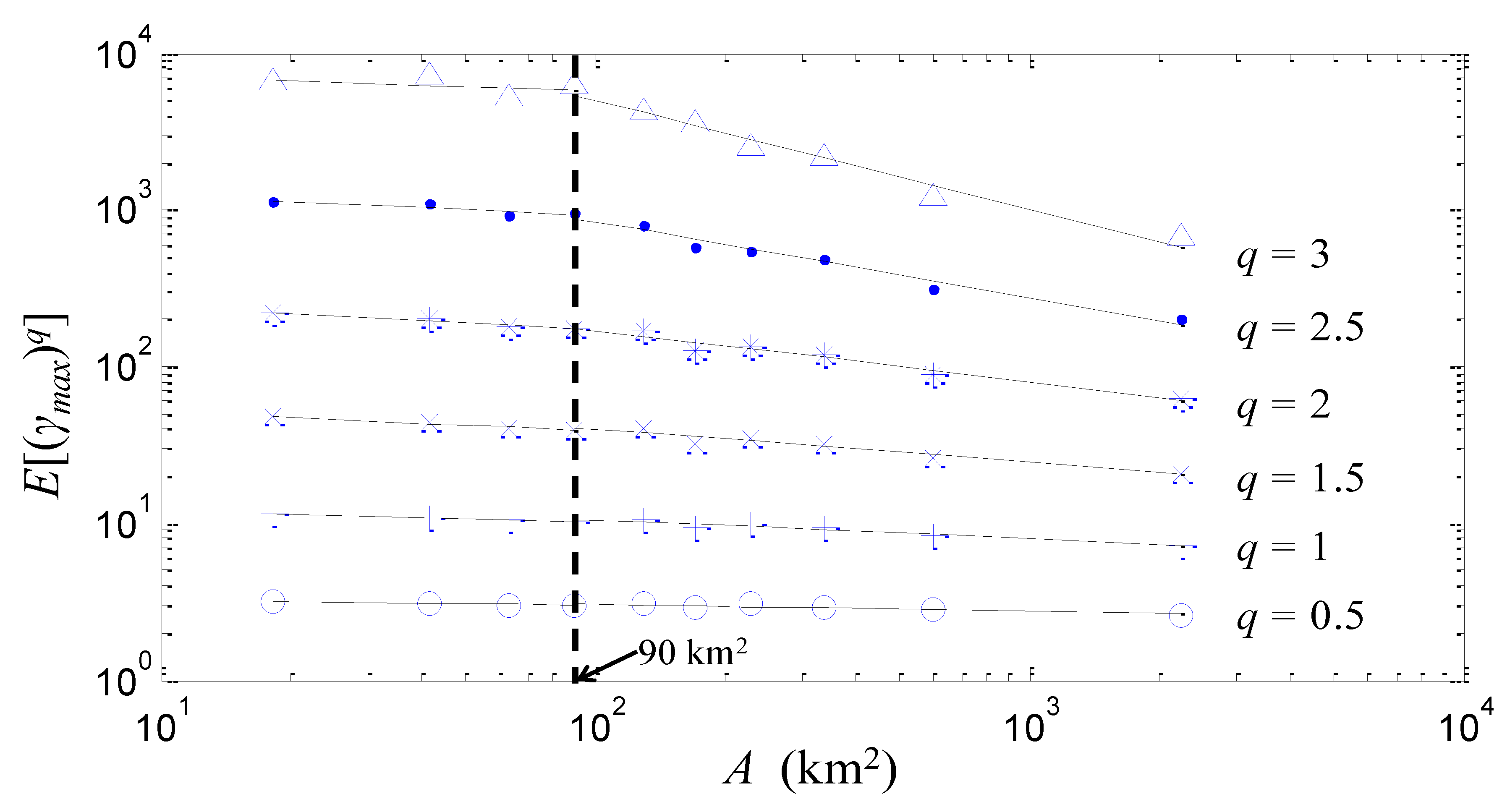
3. Analysis and Results
4. Conclusions
Author Contributions
Funding
Acknowledgments
Conflicts of Interest
References
- Dalrymple, T. Flood-frequency analyses. U.S. Geol. Surv. Water Supply Pap. 1960, 1543, 11–51. [Google Scholar]
- Benson, M.A. Factors influencing the occurrence of floods in a humid region of diverse terrain. U.S. Geol. Surv. Water Supply Pap. 1962, 1580, 62. [Google Scholar]
- Gupta, V.K.; Waymire, E.C. Multiscaling properties of spatial rainfall and river flow distributions. J. Geophys. Res. 1990, 95, 1999–2009. [Google Scholar] [CrossRef]
- Gupta, V.K.; Mesa, O.J.; Dawdy, D.R. Multiscaling theory of floods: Regional quantile analysis. Water Resour. Res. 1994, 30, 3405–3421. [Google Scholar] [CrossRef]
- Blöschl, G. Scale and scaling in hydrology (Habilitationsschrift). In Wiener Mitteilungen, Wasser-Abwasser-Gewasser; Technische Universität Wien, Institut für Wasserversorgung, Abwasserreinigung und Gewässerschutz: Wien, Austria, 1996; Volume 132, p. 346. [Google Scholar]
- Blöschl, G.; Sivapalan, M. Process controls on regional flood frequency: Coefficient of variation and basin scale. Water Resour. Res. 1997, 33, 2967–2980. [Google Scholar] [CrossRef]
- Robinson, J.S.; Sivapalan, M. An investigation into the physical causes of scaling and heterogeneity of regional flood frequency. Water Resour. Res. 1997, 33, 1045–1059. [Google Scholar] [CrossRef]
- Pandey, G.R. Assessment of scaling behavior of regional floods. J. Hydrol. Eng. 1998, 3, 169–173. [Google Scholar] [CrossRef]
- Menabde, M.; Sivapalan, M. Linking space-time variability of river runoff and rainfall fields: A dynamic approach. Adv. Water Resour. 2001, 24, 1001–1014. [Google Scholar] [CrossRef]
- Dodov, B.; Foufoula-Georgiou, E. Fluvial processes and streamflow variability: Interplay in the scale-frequency continuum and implications for scaling. Water Resour. Res. 2005, 41, W05005. [Google Scholar] [CrossRef]
- Ishak, E.; Haddad, K.; Zaman, M.; Rahman, A. Scaling property of regional floods in New South Wales Australia. Nat. Hazards 2011, 58, 1155–1167. [Google Scholar] [CrossRef]
- Ayalew, T.B.; Krajewski, W.F.; Mantilla, R. Analyzing the effects of excess rainfall properties on the scaling structure of peak discharges: Insights from a mesoscale river basin. Water Resour. Res. 2015, 51, 3900–3921. [Google Scholar] [CrossRef]
- Hosking, J.R.M.; Wallis, R. Regional Frequency Analysis: An. Approach Based on L-Moments; Cambridge University Press: Cambridge, UK, 1997. [Google Scholar]
- Smith, J.A. Representation of basin scale in flood peak distributions. Water Resour. Res. 1992, 28, 2993–2999. [Google Scholar] [CrossRef]
- Dawdy, D.R.; Griffis, V.W.; Gupta, V.K. Regional flood-frequency analysis: How we got here and where we are going. J. Hydrol. Eng. 2012, 17, 953–959. [Google Scholar] [CrossRef]
- Thomas, D.M.; Benson, M.A. Generalization of streamflow characteristics from drainage basin characteristics. U.S. Geol. Surv. Water Supply 1970, 1975, 55. [Google Scholar]
- Gupta, V.K.; Dawdy, D.R. Physical interpretations of regional variations in the scaling exponents of flood quantiles. Hydrolog. Process. 1995, 9, 347–361. [Google Scholar] [CrossRef]
- Jothityangkoon, C.; Sivapalan, M. Temporal scales of rainfall-runoff processes and spatial scaling of flood peaks: Space-time connection through catchment water balance. Adv. Water Resour. 2001, 24, 1015–1036. [Google Scholar] [CrossRef]
- Morrison, J.E.; Smith, J.A. Scaling properties of flood peaks. Extremes 2001, 4, 5–22. [Google Scholar] [CrossRef]
- Ogden, F.L.; Dawdy, D.R. Peak discharge scaling in small hortonian watershed. J. Hydrol. Eng. 2003, 8, 64–73. [Google Scholar] [CrossRef]
- Furey, P.R.; Gupta, V.K. Effects of excess rainfall on the temporal variability of observed peak-discharge power laws. Adv. Water Resour. 2005, 28, 1240–1253. [Google Scholar] [CrossRef]
- Merz, R.; Blöschl, G. A process typology of regional floods. Water Resour. Res. 2003, 39, 1340. [Google Scholar] [CrossRef]
- Merz, R.; Blöschl, G. A regional analysis of event runoff coefficients with respect to climate and catchment characteristics in Austria. Water Resour. Res. 2009, 45, 1–19. [Google Scholar] [CrossRef]
- Merz, R.; Blöschl, G. Process controls on the statistical flood moments—A data based analysis. Hydrol. Process. 2009, 23, 675–696. [Google Scholar] [CrossRef]
- Villarini, G.; Smith, J.A. Flood peak distributions for the eastern United States. Water Resour. Res. 2010, 46, W06504. [Google Scholar] [CrossRef]
- Ayalew, T.B.; Krajewski, W.F.; Mantilla, R.; Small, S.J. Exploring the effects of hillslope-channel link dynamics and excess rainfall properties on the scaling structure of peak-discharge. Adv. Water Resour. 2014, 64, 9–20. [Google Scholar] [CrossRef]
- Furey, P.R.; Troutman, B.M.; Gupta, V.K.; Krajewski, W.F. Connecting event-based scaling of flood peaks to regional flood frequency relationships. J. Hydrol. Eng. 2016, 21, 04016037. [Google Scholar] [CrossRef]
- De Michele, C.; Rosso, R. Self-similarity as a physical basis for regionalization of flood probabilities. In Proceedings of the Workshop on the Hydrometeorology, Impacts, and Management of Extreme Floods, Perugia, Italy, 13–17 November 1995. [Google Scholar]
- Gupta, V.K.; Castro, S.L.; Over, T.M. On scaling exponents of spatial peak flows from rainfall and river network geometry. J. Hydrol. Eng. 1996, 187, 81–104. [Google Scholar] [CrossRef]
- Troutman, B.M.; Over, T.M. River flow mass exponents with fractal channel networks and rainfall. Adv. Water Resour. 2001, 24, 967–989. [Google Scholar] [CrossRef]
- Gupta, V.K.; Mantilla, R.; Troutman, B.M.; Dawdy, D.; Krajewski, W.F. Generalizing a nonlinear geophysical flood theory to medium-sized river networks. Geophys. Res. Lett. 2010, 37, L11402. [Google Scholar] [CrossRef]
- Veneziano, D.; Langousis, A. Scaling and fractals in hydrology. In Advances in Data-Based Approaches for Hydrologic Modeling and Forecasting; Sivakumar, B., Berndtsson, R., Eds.; World Scientific: Singapore, 2010; pp. 107–243. [Google Scholar]
- Robinson, J.S.; Sivapalan, M. Temporal scales and hydrological regimes: Implications for flood frequency scaling. Water Resour. Res. 1997, 33, 2981–2999. [Google Scholar] [CrossRef]
- Lovejoy, S.; Schertzer, D. Multifractals and rain. In New Uncertainty Concepts in Hydrology and Hydrological Modelling; Kundzewicz, A.W., Ed.; Cambridge University Press: Cambridge, UK, 1995; pp. 61–103. [Google Scholar]
- Pandey, G.R.; Lovejoy, S.; Schertzer, D. Multifractal analysis of daily river flows including extremes for basins of five to two million square kilometres, one day to 75 years. J. Hydrol. Eng. 1998, 208, 62–81. [Google Scholar] [CrossRef]
- Mandapaka, P.V.; Krajewski, W.F.; Mantilla, R.; Gupta, V.K. Dissecting the effect or rainfall variability on the statistical structure of peak flows. Adv. Water Resour. 2009, 32, 1508–1525. [Google Scholar] [CrossRef]
- Natural Environmental Research Council. Flood Studies Report; NERC Publication: London, UK, 1975. [Google Scholar]
- Cadavid, E. Hydraulic Geometry of Channel Networks: Tests of Scaling Invariance. Master’s Thesis, University of Mississippi, Oxford, MS, USA, 1988. [Google Scholar]
- Bhatti, M.B. Extreme Rainfall, Flood Scaling and Flood Policy Options in the United States. Master’s Thesis, Department of Civil and Environmental Engineering Engineering Systems Division, Massachusetts Institute of Technology, Cambridge, MA, USA, 2000. [Google Scholar]
- Vogel, R.M.; Sankarasubramanian, A. Spatial scaling properties of annual streamflow in the United States. Hydrol. Sci. J. 2000, 45, 465–476. [Google Scholar] [CrossRef]
- O’Connell, P. On the relation of the freshwater floods of rivers to the areas and physical features of their basins and on a method of classifying rivers and streams with reference to the magnitude of their floods. Minutes Proc. Inst. Civ. Eng. 1868, 27, 204–217. [Google Scholar]
- Kuichling, E. The Relation between the Rainfall and the Discharge of Sewers in Populous Districts. Trans. Am. Soc. Civ. Eng. ASCE 1889, 20, 37–40. [Google Scholar]
- Chow, V.T.; Maidment, D.R.; Mays, L.W. Applied Hydrology; McGraw-Hill: New York, NY, USA, 1988. [Google Scholar]
- Singh, V.P. Elementary Hydrology, 1st ed.; Pearson: London, UK, 1992; ISBN 978-0132493840. [Google Scholar]
- Langousis, A.; Veneziano, D. Long-term rainfall risk from tropical cyclones in coastal areas. Wat. Resour. Res. 2009, 45, W11430. [Google Scholar] [CrossRef]
- Koutsoyiannis, D.; Langousis, A. Treaties on Water Sciences: Hydrology; Wilderer, P., Uhlenbrook, S., Eds.; Academic Press: Oxford, UK, 2011; pp. 27–78. [Google Scholar]
- Ossiander, M.; Waymire, E.C. Statistical Estimation for Multiplicative Cascades. Annals Stat. 2000, 28, 1533–1560. [Google Scholar]
- Ossiander, M.; Waymire, E.C. On Estimation Theory for Multiplicative Cascades. Sankhyā Ind. J. Stat. Ser. A 2002, 64, 323–343. [Google Scholar]
- Lashermes, B.; Abry, P.; Chainais, P. New Insights into the Estimation of Scaling Exponents. Int. J. Wavelets Multi. 2004, 2, 497–523. [Google Scholar] [CrossRef]
- Veneziano, D.; Langousis, A.; Furcolo, P. Multifractality and rainfall extremes: A review. Water Resour. Res. 2006, 42, W06D15. [Google Scholar] [CrossRef]
- Langousis, A.; Veneziano, D. Intensity–duration–frequency curves from scaling representations of rainfall. Water Resour. Res. 2007, 43. [Google Scholar] [CrossRef]
- Veneziano, D.; Furcolo, P. Improved moment scaling estimation for multifractal signals. Nonlinear Process. Geophys. 2009, 16, 641–653. [Google Scholar] [CrossRef]
- Langousis, A.; Kaleris, V. Statistical framework to simulate daily rainfall series conditional on upper-air predictor variables. Water Resour. Res. 2014, 50, 3907–3932. [Google Scholar] [CrossRef]
- Iacobellis, V.; Fiorentino, M. Derived distribution of floods based on the concept of partial area coverage with a climatic appeal. Water Resour. Res. 2000, 36, 469–482. [Google Scholar] [CrossRef]
- Fiorentino, M.; Iacobellis, V. New insights about the climatic and geologic control on the probability distribution of floods. Water Resour. Res. 2001, 37, 721–730. [Google Scholar] [CrossRef]
- Iacobellis, V.; Claps, P.; Fiorentino, M. Climatic control on the variability of flood distribution. Hydrol. Earth Syst. Sci. 2002, 6, 229–237. [Google Scholar] [CrossRef]
- Schertzer, D.; Lovejoy, S. Physical modeling and analysis of rain and clouds by anisotropic scaling of multiplicative processes. J. Geophys. Res. 1987, 92, 9693–9714. [Google Scholar] [CrossRef]
- Fraedrich, K.; Larnder, C. Scaling regimes of composite rainfall time series. Tellus Ser. A 1993, 45, 289–298. [Google Scholar] [CrossRef]
- Olsson, J. Limits and characteristics of the multifractal behavior of a high-resolution rainfall time series. Nonlinear Process. Geophys. 1995, 2, 23–29. [Google Scholar] [CrossRef]
- Marsan, D.; Schertzer, D.; Lovejoy, S. Causal space-time multifractal processes: Predictability and forecasting of rain fields. J. Geophys. Res. 1996, 101, 26333–26346. [Google Scholar] [CrossRef]
- Perica, S.; Foufoula-Georgiou, E. Linkage of scaling and thermodynamic parameters of rainfall: Results from midlatitude mesoscale convective systems. J. Geophys. Res. 1996, 101, 7431–7448. [Google Scholar] [CrossRef]
- Perica, S.; Foufoula-Georgiou, E. Model for multiscale disaggregation of spatial rainfall based on coupling meteorological and scaling descriptions. J. Geophys. Res. 1996, 101, 26347–26361. [Google Scholar] [CrossRef]
- Tessier, Y.; Lovejoy, S.; Hubert, P.; Schertzer, D.; Pecknold, S. Multifractal analysis and modelling of rainfall and river flows and scaling, causal transfer functions. J. Geophys. Res. 1996, 101, 26427–26440. [Google Scholar] [CrossRef]
- Over, T.M.; Gupta, V.K. A space-time theory of mesoscale rainfall using random cascades. J. Geophys. Res. 1996, 101, 26319–26331. [Google Scholar] [CrossRef]
- Menabde, M.; Harris, D.; Seed, A.; Austin, G.; Stow, D. Multiscaling properties of rainfall and bounded random cascades. Water Resour. Res. 1997, 33, 2823–2830. [Google Scholar] [CrossRef]
- Schmitt, F.; Vannistem, S.; Barbosa, A. Modeling of rainfall time series using two-state renewal processes and multifractals. J. Geophys. Res. 1998, 103, 23181–23193. [Google Scholar] [CrossRef]
- Olsson, J. Evaluation of a scaling cascade model for temporal rainfall disaggregation. Hydrol. Earth Syst. Sci. 1998, 2, 19–30. [Google Scholar] [CrossRef]
- Hubert, P.; Bendjoudi, H.; Schertzer, D.; Lovejoy, S. A Multifractal Explanation for Rainfall-Intensity-Duration Curves. In Heavy Rain and Flash Floods; Llasat, C., Versace, P., Ferrari, E., Eds.; Natl. Res. Counc., Group of Prev. from Hydrol. Disasters: Consenza, Italy, 1998; pp. 21–28. [Google Scholar]
- Venugopal, V.; Foufoula-Georgiou, E.; Sapozhnikov, V. A space-time downscaling model for rainfall. J. Geophys. Res. 1999, 104, 19705–19721. [Google Scholar] [CrossRef]
- Deidda, R.; Benzi, R.; Siccardi, F. Multifractal modeling of anomalous scaling laws in rainfall. Water Resour. Res. 1999, 35, 1853–1867. [Google Scholar] [CrossRef]
- Deidda, R.; Badas, M.G.; Piga, E. Space-time scaling in high-intensity Tropical Ocean Global Atmosphere Coupled Ocean-Atmosphere Response Experiment (TOGA-COARE) storms. Water Resour. Res. 2004, 40, W02506. [Google Scholar] [CrossRef]
- Deidda, R.; Badas, M.G.; Piga, E. Space-time multifractality of remotely sensed rainfall fields. J. Hydrol. Amsterdam 2006, 322, 2–13. [Google Scholar] [CrossRef]
- Deidda, R. Rainfall downscaling in a space-time multifractal framework. Water Resour. Res. 2000, 36, 1779–1794. [Google Scholar] [CrossRef]
- Güntner, A.; Olsson, J.; Calver, A.; Gannon, B. Cascade-based disaggregation of continuous rainfall time series: The influence of climate. Hydrol. Earth Syst. Sci. 2001, 5, 145–164. [Google Scholar] [CrossRef]
- Carvalho, L.M.V.; Lavallée, D.; Jones, C. Multifractal properties of evolving convective systems over tropical South America. Geophys. Res. Lett. 2002, 29, 33-1–33-4. [Google Scholar] [CrossRef]
- Pathirana, A.; Herath, S. Multifractal modeling and simulation of rain fields exhibiting spatial heterogeneity. Hydrol. Earth Syst. Sci. 2002, 6, 695–708. [Google Scholar] [CrossRef]
- Veneziano, D.; Furcolo, P. Multifractality of rainfall and intensity–duration–frequency curves. Water Resour. Res. 2002, 38, 1306–1317. [Google Scholar] [CrossRef]
- Veneziano, D.; Iacobellis, V. Multiscaling pulse representation of temporal rainfall. Water Resour. Res. 2002, 38, 13-1–13-13. [Google Scholar] [CrossRef]
- Pathirana, A.; Herath, S.; Yamada, T. Estimating rainfall distributions at high temporal resolutions using a multifractal model. Hydrol. Eart Syst. Sci. 2003, 7, 668–679. [Google Scholar] [CrossRef]
- Veneziano, D.; Langousis, A. The areal reduction factor a multifractal analysis. Water Resour. Res. 2005, 41, W07008. [Google Scholar] [CrossRef]
- Badas, M.G.; Deidda, R.; Piga, E. Orographic influences in rainfall downscaling. Adv. Geosci. 2005, 2, 285–292. [Google Scholar] [CrossRef]
- Gebremichael, M.; Over, T.M.; Krajewski, W.F. Comparison of the scaling characteristics of rainfall derived from space-based and ground-based radar observations. J. Hydrometeorol. 2006, 7, 1277–1294. [Google Scholar] [CrossRef]
- Venugopal, V.; Roux, S.G.; Foufoula-Georgiou, E.; Arneodo, A. Revisiting multifractality of high-resolution temporal rainfall using a wavelet-based formalism. Water Resour. Res. 2006, 42, W06D14. [Google Scholar] [CrossRef]
- Langousis, A.; Veneziano, D.; Furcolo, P.; Lepore, C. Multifractal rainfall extremes: Theoretical analysis and practical estimation. Chaos Solitons Fractals 2009, 39, 1182–1194. [Google Scholar] [CrossRef]
- Veneziano, D.; Furcolo, P.; Iacobellis, V. Imperfect scaling of time and space-time rainfall. J. Hydrol. 2006, 322, 105–119. [Google Scholar] [CrossRef]
- Veneziano, D.; Lepore, C.; Langousis, A.; Furcolo, P. Marginal Methods of Intensity-duration-frequency Estimation in Scaling and Nonscaling Rainfall. Wat. Resour. Res. 2007, 43. [Google Scholar] [CrossRef]
- Paulson, K.S. Spatial-temporal statistics of rainrate random fields. Radio Sci. 2002, 37, 1–8. [Google Scholar] [CrossRef]
- Tarasova, L.; Merz, R.; Kiss, A.; Basso, S.; Blöschl, G.; Merz, B.; Viglione, A.; Plötner, S.; Guse, B.; Schumann, A.; et al. Causative classification of river flood events. WIREs WATER 2019. [Google Scholar] [CrossRef] [PubMed]


| Group | Catchment Area A (km2) | Number of Catchments | Mean Value (km2) | Median Value (km2) |
|---|---|---|---|---|
| 1 | A < 31.6 | 80 | 18.09 | 19 |
| 2 | 31.6 ≤ A < 52.3 | 82 | 41.62 | 41.75 |
| 3 | 52.3 ≤ A < 74.4 | 83 | 63.24 | 62.8 |
| 4 | 74.4 ≤ A < 109.2 | 81 | 89.99 | 89.9 |
| 5 | 109.2 ≤ A < 148.1 | 81 | 128.87 | 128.9 |
| 6 | 148.1 ≤ A < 195.4 | 82 | 170.72 | 170.95 |
| 7 | 195.4 ≤ A < 272.1 | 79 | 228.73 | 229 |
| 8 | 272.1 ≤ A < 407.3 | 81 | 335.38 | 334.6 |
| 9 | 407.3 ≤ A < 900 | 80 | 602.97 | 570.35 |
| 10 | A ≥ 900 | 76 | 2240.1 | 1490 |
© 2020 by the authors. Licensee MDPI, Basel, Switzerland. This article is an open access article distributed under the terms and conditions of the Creative Commons Attribution (CC BY) license (http://creativecommons.org/licenses/by/4.0/).
Share and Cite
Perdios, A.; Langousis, A. Revisiting the Statistical Scaling of Annual Discharge Maxima at Daily Resolution with Respect to the Basin Size in the Light of Rainfall Climatology. Water 2020, 12, 610. https://doi.org/10.3390/w12020610
Perdios A, Langousis A. Revisiting the Statistical Scaling of Annual Discharge Maxima at Daily Resolution with Respect to the Basin Size in the Light of Rainfall Climatology. Water. 2020; 12(2):610. https://doi.org/10.3390/w12020610
Chicago/Turabian StylePerdios, Anastasios, and Andreas Langousis. 2020. "Revisiting the Statistical Scaling of Annual Discharge Maxima at Daily Resolution with Respect to the Basin Size in the Light of Rainfall Climatology" Water 12, no. 2: 610. https://doi.org/10.3390/w12020610
APA StylePerdios, A., & Langousis, A. (2020). Revisiting the Statistical Scaling of Annual Discharge Maxima at Daily Resolution with Respect to the Basin Size in the Light of Rainfall Climatology. Water, 12(2), 610. https://doi.org/10.3390/w12020610