Drought Monitoring Based on Remote Sensing in a Grain-Producing Region in the Cerrado–Amazon Transition, Brazil

 ,
,  , , , and
Abstract
:1. Introduction
2. Materials and Methods
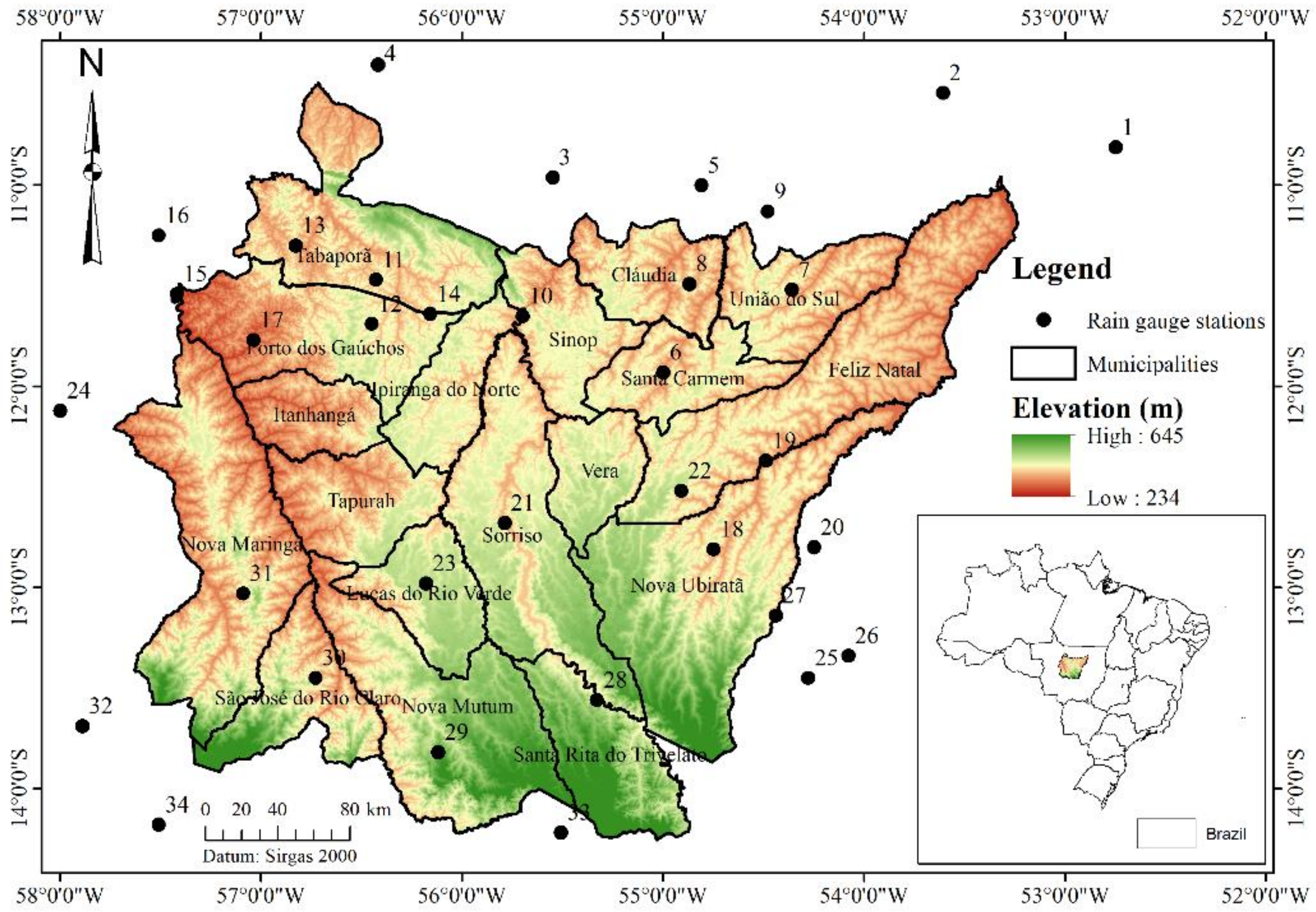
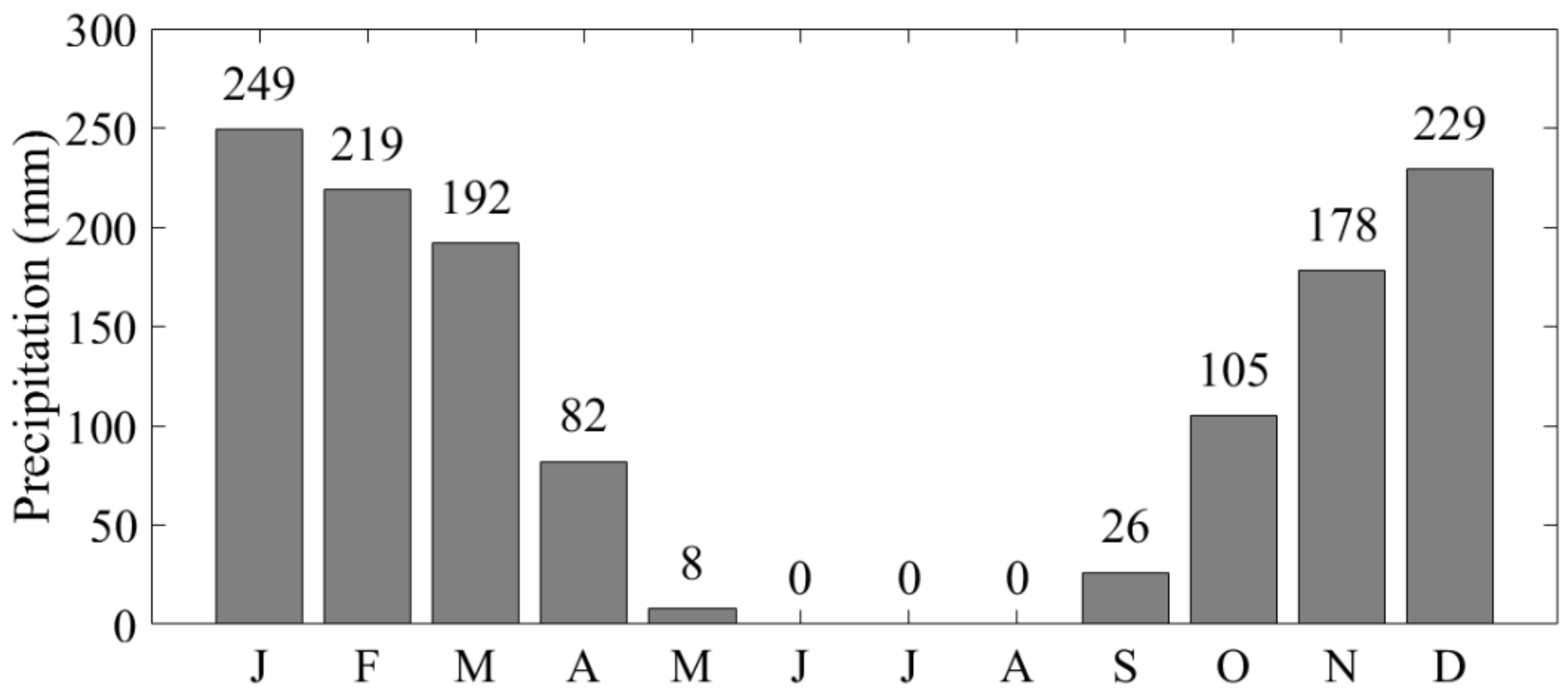
2.1. Study Area and Database
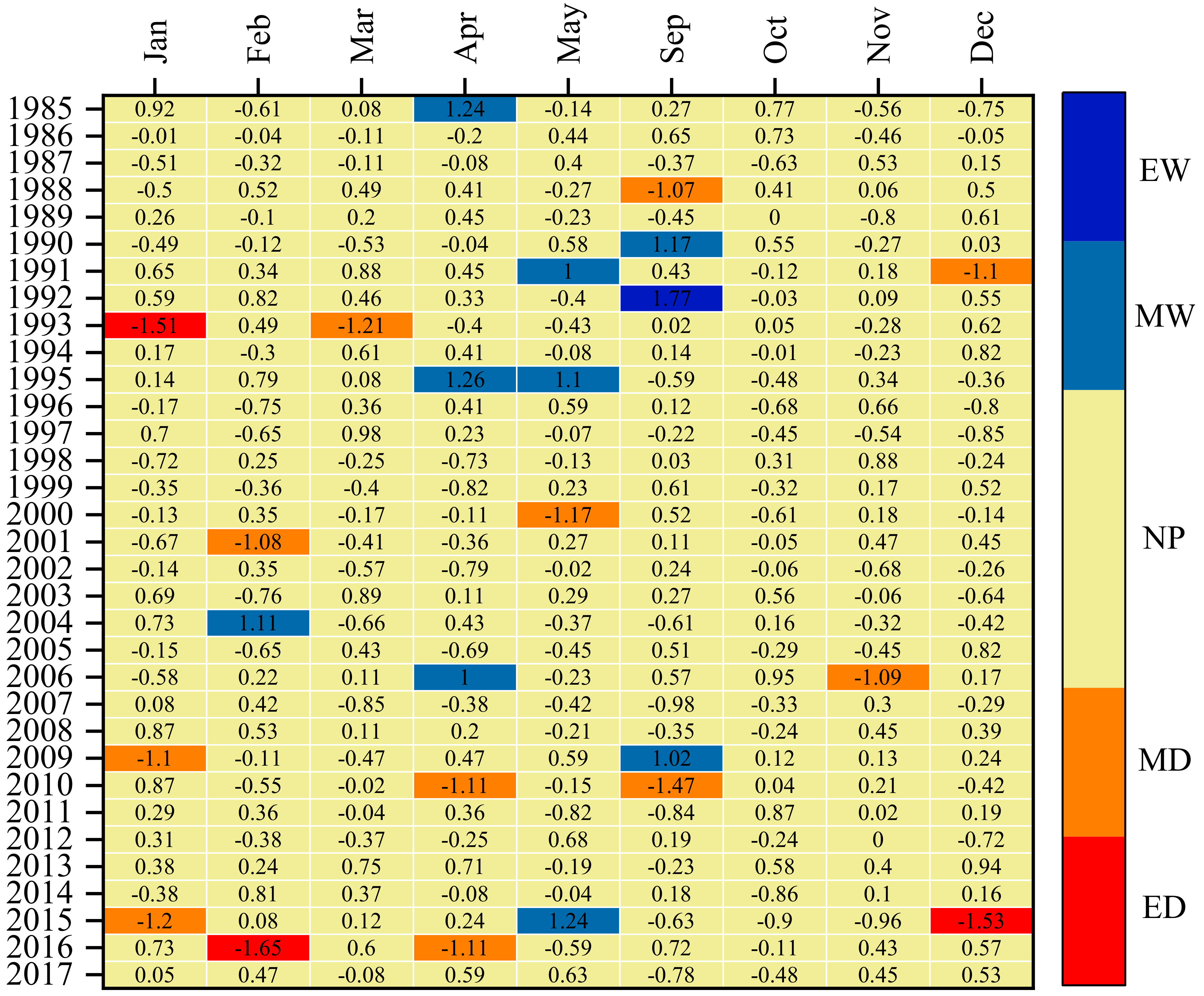
2.2. Drought Detection with SPI Obtained Based on Data from Rain Gauge Stations
2.3. SPI Estimation Using Orbital Remote Sensing
3. Results and Discussion
3.1. Drought Detection with SPI Obtained Based on Data from Rain Gauge Stations
3.2. Drought Detection with SPI Obtained Based on Orbital Remote Sensing Data
4. Conclusions
- -
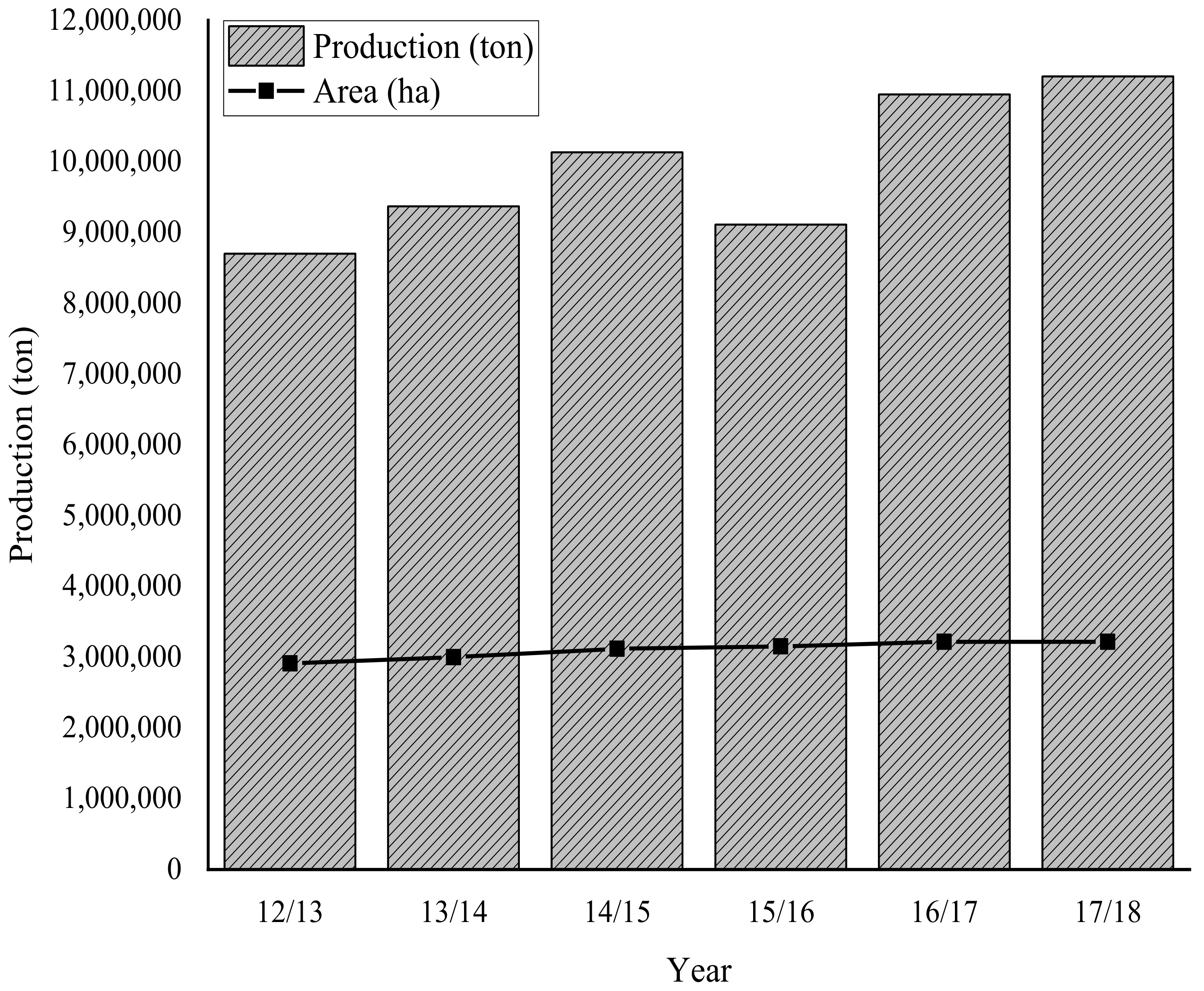
- The standardized precipitation index (SPI) is effective in characterizing and monitoring the meteorological drought in the north–central region of the State of Mato Grosso. There is a relationship between the drought events detected by SPI and the reduction in grain production that occurs under rainfed conditions.
- -
- The SPI calculated from historical rain series estimated by remote sensing allows monitoring droughts. This approach allows for a higher detail of the spatial variability of droughts in the Cerrado–Amazon transition region located in the north–central region of the State of Mato Grosso, especially during the soybean development period.
- -
- The indirect measures of precipitation from remote sensing associated with SPI on the monthly scale (SPI-1) that best perform for detecting droughts in the study region are PERSIANN-CCS (April), CHIRPS-2.0 (January, February, March, May, September and November), and GPM-3IMERGMv6 (December).
Author Contributions
Funding
Conflicts of Interest
Appendix A

| ID | Code | Name | Latitude (°) | Longitude (°) | Available Data |
|---|---|---|---|---|---|
| 1 | 01052000 | Vila São José Xingu | −10.81 | −52.75 | 1976–2017 |
| 2 | 01053001 | Fazenda Santa Emília | −10.54 | −53.61 | 1976–2017 |
| 3 | 01055003 | Fazenda Tratex | −10.96 | −55.55 | 1994–2017 |
| 4 | 01056001 | Estância Buriti | −10.40 | −56.42 | 2000–2017 |
| 5 | 01154000 | Rancho de Deus | −11.00 | −54.81 | 1985–2017 |
| 6 | 01154001 | Santa Felicidade | −11.93 | −55.00 | 1982–2017 |
| 7 | 01154002 | Fazenda Rio Negro | −11.52 | −54.36 | 1999–2017 |
| 8 | 01154004 | Cláudia | −11.49 | −54.87 | 2004–2017 |
| 9 | 01154005 | Riacho de Deus | −11.13 | −54.48 | 2006–2017 |
| 10 | 01155000 | Cachoeirão | −11.65 | −55.70 | 1975–2017 |
| 11 | 01156000 | Fazenda Itauba | −11.47 | −56.43 | 1982–2017 |
| 12 | 01156001 | Sinop (Fazenda Sempre Verde) | −11.69 | −56.45 | 1983–2017 |
| 13 | 01156002 | Tabaporã | −11.30 | −56.83 | 2004–2017 |
| 14 | 01156003 | Nova Americana | −11.64 | −56.16 | 2004–2017 |
| 15 | 01157000 | Porto dos Gaúchos | −11.54 | −57.42 | 1973–2017 |
| 16 | 01157001 | Juara | −11.25 | −57.51 | 1983–2017 |
| 17 | 01157002 | Olho D’água | −11.77 | −57.04 | 1999–2017 |
| 18 | 01254001 | Agrovensa | −12.81 | −54.75 | 1982–2017 |
| 19 | 01254002 | Consul | −12.37 | −54.49 | 1997–2012 |
| 20 | 01254003 | Agropecuária Três Irmãos | −12.80 | −54.25 | 2000–2017 |
| 21 | 01255001 | Teles Pires | −12.68 | −55.79 | 1976–2017 |
| 22 | 01255002 | Núcleo Colonial Rio Ferro | −12.52 | −54.91 | 1976–2017 |
| 23 | 01256002 | Fazenda Divisão | −12.98 | −56.18 | 1999–2017 |
| 24 | 01257000 | Brasnorte | −12.12 | −58.00 | 1984–2017 |
| 25 | 01354000 | Fazenda Agrochapada | −13.45 | −54.28 | 1976–2017 |
| 26 | 01354001 | Agropecuária MALP | −13.34 | −54.08 | 1999–2017 |
| 27 | 01354002 | Fazenda Itaguaçu | −13.14 | −54.44 | 2003–2017 |
| 28 | 01355001 | Porto Roncador | −13.56 | −55.33 | 1985–2017 |
| 29 | 01356002 | Nova Mutum | −13.82 | −56.12 | 1985–2017 |
| 30 | 01356004 | São José do Rio Claro | −13.45 | −56.73 | 2004–2017 |
| 31 | 01357000 | Nova Maringá | −13.03 | −57.09 | 1982–2017 |
| 32 | 01357001 | Campo Novo do Parecis | −13.69 | −57.89 | 2000–2017 |
| 33 | 01455009 | Fazenda Rio Novo | −14.22 | −55.51 | 2000–2017 |
| 34 | 01457003 | Deciolândia | −14.18 | −57.51 | 1982–2017 |
References
- Bhuyan-Erhardt, U.; Erhardt, T.M.; Laaha, G.; Zang, C.; Parajka, J.; Menzel, A. Validation of drought indices using environmental indicators: Streamflow and carbon flux data. Agric. For. Meteorol. 2018, 265, 218–226. [Google Scholar] [CrossRef]
- Cui, Y.; Jiang, S.; Jin, J.; Ning, S.; Feng, P. Quantitative assessment of soybean drought loss sensitivity at different growth stages based on S-shaped damage curve. Agric. Water Manag. 2019, 213, 821–832. [Google Scholar] [CrossRef]
- Lai, C.; Zhong, R.; Wang, Z.; Wu, X.; Chen, X.; Wang, P.; Lian, Y. Monitoring hydrological drought using long-term satellite-based precipitation data. Sci. Total Environ. 2019, 649, 1198–1208. [Google Scholar] [CrossRef]
- Mera, G.A. Drought and its impacts in Ethiopia. Weather Clim. Extrem. 2018, 22, 24–35. [Google Scholar] [CrossRef]
- Shen, Z.; Zhang, Q.; Singh, V.P.; Sun, P.; Song, C.; Yu, H. Agricultural drought monitoring across Inner Mongolia, China: Model development, spatiotemporal patterns and impacts. J. Hydrol. 2019, 571, 793–804. [Google Scholar] [CrossRef]
- Shiru, M.S.; Shahid, S.; Chung, E.; Alias, N. Changing characteristics of meteorological droughts in Nigeria during 1901–2010. Atmos. Res. 2019, 223, 60–73. [Google Scholar] [CrossRef]
- Azadi, H.; Keramati, P.; Taheri, F.; Rafiaani, P.; Teklemariam, D.; Ebrehiwot, K.; Hosseininia, G.; Van Passel, S.; Lebailly, P.; Witlox, F. Agricultural land conversion: Reviewing drought impacts and coping strategies. Int. J. Disaster Risk Reduct. 2018, 31, 184–195. [Google Scholar] [CrossRef]
- Baik, J.; Zohaib, M.; Kim, U.; Aadil, M.; Choi, M. Agricultural drought assessment based on multiple soil moisture products. J. Arid Environ. 2019, 167, 43–55. [Google Scholar] [CrossRef]
- Freire-González, J.; Decker, C.; Hall, J.W. The Economic Impacts of Droughts: A Framework for Analysis. Ecol. Econ. 2017, 132, 196–204. [Google Scholar] [CrossRef]
- Haile, G.G.; Tang, Q.; Sun, S.; Huang, Z.; Zhang, X.; Liu, X. Droughts in East Africa: Causes, impacts and resilience. Earth Sci. Rev. 2019, 193, 146–161. [Google Scholar] [CrossRef]
- Zink, M.; Samaniego, L.; Kumar, R.; Thober, S.; Mai, J.; Schäfer, D.; Marx, A. A National Scale Planning Tool for Agricultural Droughts in Germany. In Advances in Chemical Pollution, Environmental Management and Protection, 1st ed.; Elsevier: Amsterdam, The Netherlands, 2018; Volume 1, pp. 147–169. [Google Scholar]
- Jääskeläinen, J.; Veijalainen, N.; Syri, S.; Marttunen, M.; Zakeri, B. Energy security impacts of a severe drought on the future Finnish energy system. J. Environ. Manag. 2018, 217, 542–554. [Google Scholar] [CrossRef] [PubMed]
- Yao, N.; Li, Y.; Lei, T.; Peng, L. Drought evolution, severity and trends in mainland China over 1961–2013. Sci. Total Environ. 2018, 616, 73–89. [Google Scholar] [CrossRef]
- Corlett, R.T. The Impacts of Droughts in Tropical Forests. Trends Plant Sci. 2016, 21, 584–593. [Google Scholar] [CrossRef] [PubMed]
- Jedd, T.M.; Bhattacharya, D.; Pesek, C.; Hayes, M.J. Drought impacts and management in prairie and sandhills state parks. J. Outdoor Recreat. Tour. 2019, 26, 1–12. [Google Scholar] [CrossRef]
- Jha, S.; Srivastava, R. Impact of drought on vegetation carbon storage in arid and semi-arid regions. Remote Sens. Appl. Soc. Environ. 2018, 11, 22–29. [Google Scholar] [CrossRef]
- Silva, S.S.; Fearnside, P.M.; Graça, P.M.L.A.; Brown, I.F.; Alencar, A.; Melo, A. Dynamics of forest fires in the southwestern Amazon. For. Ecol. Manag. 2018, 424, 312–322. [Google Scholar] [CrossRef]
- Mozny, M.; Trnka, M.; Zalud, Z.; Hlavinka, P.; Nekovar, J.; Potop, V.; Virag, M. Use of a soil moisture network for drought monitoring in the Czech Republic. Theor. Appl. Climatol. 2012, 107, 99–111. [Google Scholar] [CrossRef]
- Forootan, E.; Khaki, M.; Schumacher, M.; Wulfmeyer, V.; Mehrnegar, N.; Van Dijk, A.I.J.M.; Brocca, L.; Farzaneh, S.; Akinluyi, F.; Ramillien, G.; et al. Understanding the global hydrological droughts of 2003–2016 and their relationships with teleconnections. Sci. Total Environ. 2019, 650, 2587–2604. [Google Scholar] [CrossRef] [Green Version]
- Oliveira-Júnior, J.F.; Gois, G.; Terassi, P.M.B.; Silva Junior, C.A.; Blanco, C.J.C.; Sobral, B.S.; Gasparini, K.A.C. Drought severity based on the SPI index and its relation to the ENSO and PDO climatic variability modes in the regions North and Northwest of the State of Rio de Janeiro—Brazil. Atmos. Res. 2018, 212, 91–105. [Google Scholar] [CrossRef]
- Zuo, D.; Cai, S.; Xu, Z.; Peng, D.; Kan, G.; Sun, W.; Pang, B.; Yang, H. Assessment of meteorological and agricultural droughts using in-situ observations and remote sensing data. Agric. Water Manag. 2019, 222, 125–138. [Google Scholar] [CrossRef]
- Zhong, R.; Chen, X.; Lai, C.; Wang, Z.; Lian, Y.; Yu, H.; Wu, X. Drought monitoring utility of satellite-based precipitation products across mainland China. J. Hydrol. 2019, 568, 343–359. [Google Scholar] [CrossRef]
- Solh, M.; Van Ginkel, M. Drought preparedness and drought mitigation in the developing world’s drylands. Weather. Clim. Extrem. 2014, 3, 62–66. [Google Scholar] [CrossRef] [Green Version]
- Niu, J.; Kang, S.; Zhang, X.; Fu, J. Vulnerability analysis based on drought and vegetation dynamics. Ecol. Indic. 2019, 105, 329–336. [Google Scholar] [CrossRef]
- West, H.; Quinn, N.; Horswell, M. Remote sensing for drought monitoring & impact assessment: Progress, past challenges and future opportunities. Remote Sens. Environ. 2019, 232, 1–14. [Google Scholar] [CrossRef]
- Sousa Júnior, M.A.; Lacruz, M.S.P. Remote Sensing for Drought. In Remote Sensing for Disasters, 1st ed.; Oficina de Textos: São Paulo, Brazil, 2015; Volume 1, pp. 149–174. (In Portuguese) [Google Scholar]
- Mckee, T.B.; Doesken, N.J.; Kleist, J. The relationship of drought frequency and duration to time scales. In Proceedings of the 8th Conference of Applied Climatology, Anaheim, CA, USA, 17–22 January 1993; American Meterological Society: Anaheim, CA, USA, 1993; pp. 179–184. [Google Scholar]
- Tian, L.; Yuan, S.; Quiring, S.M. Evaluation of six indices for monitoring agricultural drought in the south-central United States. Agric. For. Meteorol. 2018, 249, 107–119. [Google Scholar] [CrossRef]
- IMEA (Instituto Mato-grossense de Economia Agropecuária). 4th Soybean Crop Estimate—2019/20. Available online: http://www.imea.com.br/imea-site/relatorios-mercado-detalhe?c=4&s=9 (accessed on 13 August 2020). (In Portuguese).
- IMEA (Instituto Mato-grossense de Economia Agropecuária). 5th Corn Crop Estimate—2019/20. Available online: http://www.imea.com.br/imea-site/relatorios-mercado-detalhe?c=4&s=9 (accessed on 13 August 2020). (In Portuguese).
- Câmara, G.M.S. Preparo do Solo e Plantio. In Soybean: From Planting to Harvest, 1st ed.; Editora UFV: Viçosa, Brazil, 2015; Volume 1, pp. 66–109. (In Portuguese) [Google Scholar]
- Galvão, J.C.C.; Trogello, E.; Pereira, L.P.L. Second Crop Corn. In Corn: From Planting to Harvest, 2nd ed.; Editora UFV: Viçosa, Brazil, 2017; Volume 2, pp. 210–228. (In Portuguese) [Google Scholar]
- Souza, A.P.; Mota, L.L.; Zamadei, T.; Martim, C.C.; Almeida, F.T.; Paulino, J. Climate Classification and Climatological Water Balance in the State of Mato Grosso. Nativa 2013, 1, 34–43. [Google Scholar] [CrossRef]
- HidroWeb (Sistemas de Informações Hidrológicas). Historical Hidrological Dataset. Available online: http://www.snirh.gov.br/hidroweb/serieshistoricas (accessed on 24 May 2020). (In Portuguese)
- Uliana, E.M.; Reis, E.F.; Silva, J.G.F.; Xavier, A.C. Probable Monthly and Annual Precipitation for the State of Espírito Santo. Irriga 2013, 18, 139–147. [Google Scholar] [CrossRef] [Green Version]
- INDEA (Instituto de Defesa Agropecuária). Normative Instruction SEDEC/INDEA-MT nº 002/2.015. Available online: http://www.indea.mt.gov.br (accessed on 13 August 2020). (In Portuguese)
- Naghettini, M. Fundamentals of Statistical Hydrology, 1st ed.; Springer: Cham, Switzerland, 2017; Volume 1, p. 674. (In Portuguese) [Google Scholar]
- Massey, F.J., Jr. The Kolmogorov-Smirnov Test for Goodness of Fit. J. Am. Stat. Assoc. 1951, 46, 68–78. [Google Scholar] [CrossRef]
- Abramowitz, M.; Stegun, I.A. Handbook of Mathematical Function, 1st ed.; Dover Publications: New York, NY, USA, 1965; Volume 1, 1046p. [Google Scholar]
- Ma, Z.; Redmond, R.L. Tau coefficients for accuracy assessment of classification of remote sensing data. Photogramm. Eng. Remote Sens. 1995, 61, 435–439. [Google Scholar]
- Landis, J.R.; Koch, G.G. The measurement of observe agreement for categorical data. Biometrics 1977, 31, 159–174. [Google Scholar] [CrossRef] [Green Version]
- Mcnemar, Q. Note on the sampling error of the difference between correlated proportions or percentages. Psychometrika 1947, 12, 153–157. [Google Scholar] [CrossRef] [PubMed]
- Moreira, M.A. Fundamentals of Remote Sensing and Application Methodologies; Editora UFV: Viçosa, Brazil, 2011; pp. 360–362. (In Portuguese) [Google Scholar]
- Leeuw, J.; Jia, H.; Yang, L.; Liu, X.; Schmidt, K.; Skidmore, A.K. Comparing accuracy assessments to infer superiority of image classification methods. Int. J. Remote Sens. 2006, 27, 223–232. [Google Scholar] [CrossRef]
- Uliana, E.M.; Reis, E.F.; Souza, A.P.; Silva, J.G.F.; Xavier, A.C. Use of the standardized precipitation index for the northern region of the state of Espírito Santo. Irriga 2015, 20, 414–428. [Google Scholar] [CrossRef] [Green Version]
- IMEA (Instituto Mato-Grossense de Economia Agropecuária). 6th Soybean Crop Estimate—2017/18 in Mato Grosso. Available online: http://www.imea.com.br/ (accessed on 10 August 2019). (In Portuguese).
- Rivera, J.A.; Hinrichs, S.; Marianetti, G. Using CHIRPS Dataset to Assess Wet and Dry Conditions along the Semiarid Central-Western Argentina. Adv. Meteorol. 2019, 2019, 1–18. [Google Scholar] [CrossRef] [Green Version]
- Cao, Y.; Zhang, W.; Wang, W. Evaluation of TRMM 3B43 data over the Yangtze River Delta of China. Sci. Rep. 2018, 8, 5290. [Google Scholar] [CrossRef] [PubMed] [Green Version]
- Wruck, D.S.M.; Spera, S.T.; Tadashi, J.Y.; Menegucci, J.; Lulu, J.; Magalhães, C.; Zolin, C.; Assad, E. Status of the 2015/2016 Crop: Report Requested by Aprosoja and Prepared by Embrapa Agrossilvipastoril. Available online: https://www.embrapa.br/documents (accessed on 18 August 2020). (In Portuguese).
- Villarini, G.; Krajewski, W.F. Review of the different Sources of uncertainty in single polarization Radar-based estimates of rainfall. Surv. Geophys. 2010, 31, 107–129. [Google Scholar] [CrossRef]
- Cui, C.; Xu, J.; Zeng, J.; Chen, K.S.; Bai, X.; Lu, H.; Chen, Q.; Zhao, T. Soil moisture mapping from satellites: An intercomparison of SMAP, SMOS, FY3B, AMSR2, and ESA CCI over two dense network regions at different spatial scales. Remote Sens. 2018, 10, 33. [Google Scholar] [CrossRef] [Green Version]
- Zeng, J.; Li, Z.; Chen, Q.; Bi, H.; Qiu, J.; Zou, P. Evaluation of remotely sensed and reanalysis soil moisture products over the Tibetan Plateau using in-situ observations. Remote Sens. Environ. 2015, 163, 91–110. [Google Scholar] [CrossRef]


| Class | SPI Value | Simplified Classification |
|---|---|---|
| Extremely wet (EW) | SPI ≥ 1.5 | Without drought |
| Moderately wet (MW) | 1 ≤ SPI < 1.5 | |
| Normal precipitation (NP) | 1 < SPI < −1 | |
| Moderately dry (MD) | −1.5 < SPI ≤ −1 | With drought |
| Extremely dry (ED) | SPI ≤ −1.5 |
| Product | Spatial Resolution | Period | Database Address |
|---|---|---|---|
| CHIRPS-2.0 | 0.05° | 1981–2020 | https://www.chc.ucsb.edu/data/chirps |
| PERSIANN-CDR | 0.25° | 1983–2020 | https://chrsdata.eng.uci.edu/ |
| PERSIANN-CCS | 0.04° | 2003–2020 | |
| PERSIANN | 0.25° | 2000–2020 | |
| GPM-3IMERGMv6 | 0.10° | 2000–2020 | https://giovanni.gsfc.nasa.gov/giovanni/ |
| GPM-3IMERGDLv6 | 0.10° | 2000–2020 |
| Kappa or Tau (τ) | Drought Map Quality |
|---|---|
| <0.00 | Very poor |
| 0.00–0.20 | Poor |
| 0.20–0.40 | Moderate |
| 0.40–0.60 | Good |
| 0.60–0.80 | Very good |
| 0.80–1.00 | Excellent |
| Result | January | February | March | April | May | September | October | November | December |
|---|---|---|---|---|---|---|---|---|---|
| Z | 0.418 | 0.201 | −0.124 | −0.759 | −0.232 | −0.961 | −1.224 | 1.038 | 0.294 |
| p-value | 0.676 | 0.840 | 0.901 | 0.448 | 0.816 | 0.337 | 0.221 | 0.299 | 0.768 |
| Month | Product | Global Accuracy | CI-Accuracy | Tau | Kappa | Kappa CLASSIFICATION | p-Value—McNemar |
|---|---|---|---|---|---|---|---|
| January | CHIRPS-2.0 | 0.86 | 0.82–0.89 | 0.72 | 0.50 | Good | 0.228 |
| PERSIANN-CDR | 0.84 | 0.80–0.87 | 0.68 | 0.41 | Good | 0.018 | |
| PERSIANN-CCS | 0.81 | 0.76–0.85 | 0.62 | 0.31 | Moderate | 0.791 | |
| PERSIANN | 0.85 | 0.81–0.88 | 0.70 | 0.43 | Good | 0.161 | |
| GPM-3IMERGMv6 | 0.86 | 0.81–0.89 | 0.72 | 0.46 | Good | 0.112 | |
| GPM-3IMERGDLv6 | 0.86 | 0.83–0.88 | 0.72 | 0.50 | Good | 0.097 | |
| February | CHIRPS-2.0 | 0.85 | 0.82–0.88 | 0.7 | 0.50 | Good | 0.723 |
| PERSIANN-CDR | 0.82 | 0.79–0.85 | 0.64 | 0.37 | Moderate | 0.299 | |
| PERSIANN-CCS | 0.84 | 0.79–0.88 | 0.68 | 0.40 | Good | 0.567 | |
| PERSIANN | 0.79 | 0.74–0.83 | 0.58 | 0.24 | Moderate | 0.194 | |
| GPM-3IMERGMv6 | 0.84 | 0.79–0.87 | 0.68 | 0.47 | Good | 0.504 | |
| GPM-3IMERGDLv6 | 0.84 | 0.79–0.88 | 0.68 | 0.44 | Good | 0.418 | |
| March | CHIRPS-2.0 | 0.82 | 0.78–0.85 | 0.64 | 0.31 | Moderate | 0.668 |
| PERSIANN-CDR | 0.80 | 0.76–0.83 | 0.60 | 0.26 | Moderate | 0.121 | |
| PERSIANN-CCS | 0.82 | 0.77–0.86 | 0.64 | 0.31 | Moderate | 0.418 | |
| PERSIANN | 0.72 | 0.66–0.76 | 0.44 | 0.04 | Poor | 0.036 | |
| GPM-3IMERGMv6 | 0.79 | 0.75–0.84 | 0.58 | 0.30 | Moderate | 0.228 | |
| GPM-3IMERGDLv6 | 0.79 | 0.74–0.83 | 0.58 | 0.27 | Moderate | 0.342 | |
| April | CHIRPS-2.0 | 0.83 | 0.79–0.86 | 0.66 | 0.42 | Good | 0.030 |
| PERSIANN-CDR | 0.80 | 0.76–0.83 | 0.6 | 0.36 | Moderate | 0.001 | |
| PERSIANN-CCS | 0.84 | 0.79–0.88 | 0.68 | 0.41 | Good | 0.999 | |
| PERSIANN | 0.82 | 0.78–0.86 | 0.64 | 0.41 | Good | 0.093 | |
| GPM-3IMERGMv6 | 0.83 | 0.78–0.86 | 0.66 | 0.40 | Good | 0.434 | |
| GPM-3IMERGDLv6 | 0.81 | 0.76–0.85 | 0.62 | 0.35 | Moderate | 0.175 | |
| May | CHIRPS-2.0 | 0.83 | 0.80–0.87 | 0.66 | 0.38 | Moderate | 0.075 |
| PERSIANN-CDR | 0.78 | 0.74–0.81 | 0.56 | 0.18 | Poor | 0.021 | |
| PERSIANN-CCS | 0.78 | 0.72–0.84 | 0.56 | 0.16 | Poor | 0.033 | |
| PERSIANN | 0.81 | 0.76–0.85 | 0.62 | 0.17 | Poor | 0.048 | |
| GPM-3IMERGMv6 | 0.82 | 0.77–0.86 | 0.64 | 0.28 | Moderate | 0.007 | |
| GPM-3IMERGDLv6 | 0.80 | 0.75–0.84 | 0.6 | 0.27 | Moderate | 1.17 × 10⁻⁴ | |
| September | CHIRPS-2.0 | 0.88 | 0.85–0.91 | 0.76 | 0.55 | Good | 0.602 |
| PERSIANN-CDR | 0.87 | 0.84–0.90 | 0.74 | 0.52 | Good | 0.335 | |
| PERSIANN-CCS | 0.80 | 0.74–0.85 | 0.60 | 0.14 | Poor | 3.47 × 10⁻⁴ | |
| PERSIANN | 0.82 | 0.78–0.87 | 0.64 | 0.38 | Moderate | 0.504 | |
| GPM-3IMERGMv6 | 0.88 | 0.84–0.91 | 0.76 | 0.55 | Good | 0.154 | |
| GPM-3IMERGDLv6 | 0.87 | 0.83–0.91 | 0.74 | 0.52 | Good | 0.291 | |
| October | CHIRPS-2.0 | 0.79 | 0.75–0.83 | 0.58 | 0.25 | Moderate | 0.028 |
| PERSIANN-CDR | 0.75 | 0.71–0.78 | 0.5 | 0.10 | Poor | 0.046 | |
| PERSIANN-CCS | 0.77 | 0.72–0.82 | 0.54 | 0.12 | Poor | 0.039 | |
| PERSIANN | 0.75 | 0.70–0.79 | 0.5 | 0.04 | Poor | 0.027 | |
| GPM-3IMERGMv6 | 0.77 | 0.73–0.82 | 0.54 | 0.18 | Poor | 0.004 | |
| GPM-3IMERGDLv6 | 0.81 | 0.77–0.85 | 0.62 | 0.19 | Poor | 0.011 | |
| November | CHIRPS-2.0 | 0.82 | 0.78–0.85 | 0.64 | 0.33 | Moderate | 0.594 |
| PERSIANN-CDR | 0.81 | 0.77–0.84 | 0.62 | 0.27 | Moderate | 0.430 | |
| PERSIANN-CCS | 0.81 | 0.76–0.85 | 0.62 | 0.33 | Moderate | 0.895 | |
| PERSIANN | 0.76 | 0.72–0.81 | 0.52 | 0.13 | Poor | 0.037 | |
| GPM-3IMERGMv6 | 0.80 | 0.75–0.84 | 0.6 | 0.29 | Moderate | 0.999 | |
| GPM-3IMERGDLv6 | 0.81 | 0.77–0.85 | 0.62 | 0.33 | Moderate | 0.900 | |
| December | CHIRPS-2.0 | 0.82 | 0.79–0.86 | 0.64 | 0.35 | Moderate | 0.278 |
| PERSIANN-CDR | 0.81 | 0.78–0.84 | 0.62 | 0.31 | Moderate | 0.617 | |
| PERSIANN-CCS | 0.78 | 0.73–0.83 | 0.56 | 0.25 | Moderate | 0.456 | |
| PERSIANN | 0.76 | 0.71–0.80 | 0.52 | 0.18 | Poor | 0.022 | |
| GPM-3IMERGMv6 | 0.83 | 0.79–0.87 | 0.66 | 0.38 | Moderate | 0.999 | |
| GPM-3IMERGDLv6 | 0.77 | 0.71–0.81 | 0.54 | 0.13 | Poor | 8.22 × 10⁻⁴ |
Publisher’s Note: MDPI stays neutral with regard to jurisdictional claims in published maps and institutional affiliations. |
© 2020 by the authors. Licensee MDPI, Basel, Switzerland. This article is an open access article distributed under the terms and conditions of the Creative Commons Attribution (CC BY) license (http://creativecommons.org/licenses/by/4.0/).
Share and Cite
Carvalho, M.Â.C.C.d.; Uliana, E.M.; Silva, D.D.d.; Aires, U.R.V.; Martins, C.A.d.S.; Sousa Junior, M.F.d.; Cruz, I.F.d.; Mendes, M.A.d.S.A. Drought Monitoring Based on Remote Sensing in a Grain-Producing Region in the Cerrado–Amazon Transition, Brazil. Water 2020, 12, 3366. https://doi.org/10.3390/w12123366
Carvalho MÂCCd, Uliana EM, Silva DDd, Aires URV, Martins CAdS, Sousa Junior MFd, Cruz IFd, Mendes MAdSA. Drought Monitoring Based on Remote Sensing in a Grain-Producing Region in the Cerrado–Amazon Transition, Brazil. Water. 2020; 12(12):3366. https://doi.org/10.3390/w12123366
Chicago/Turabian StyleCarvalho, Mairon Ânderson Cordeiro Correa de, Eduardo Morgan Uliana, Demetrius David da Silva, Uilson Ricardo Venâncio Aires, Camila Aparecida da Silva Martins, Marionei Fomaca de Sousa Junior, Ibraim Fantin da Cruz, and Múcio André dos Santos Alves Mendes. 2020. "Drought Monitoring Based on Remote Sensing in a Grain-Producing Region in the Cerrado–Amazon Transition, Brazil" Water 12, no. 12: 3366. https://doi.org/10.3390/w12123366
APA StyleCarvalho, M. Â. C. C. d., Uliana, E. M., Silva, D. D. d., Aires, U. R. V., Martins, C. A. d. S., Sousa Junior, M. F. d., Cruz, I. F. d., & Mendes, M. A. d. S. A. (2020). Drought Monitoring Based on Remote Sensing in a Grain-Producing Region in the Cerrado–Amazon Transition, Brazil. Water, 12(12), 3366. https://doi.org/10.3390/w12123366