1. Introduction
Under ‘natural’ conditions, the hydrological water cycle is in a state of balance. In numerous ways, however, basins are being artificially modified by land use changes and urban development. These modifications affect natural processes and can result in increased flood or drought risk, due to reduced storage and faster runoff, as well as numerous other impacts reducing the value of the ecosystem services that healthy aquifers and river basins can provide [
1] (p. 31).
Cities and their residents can be particularly vulnerable to the negative impacts of man-made river basin processes and future changes resulting from climate change.
1.1. Urban Needs
Cities need to improve their understanding of how river basin management and nature-based measures can be hydrogeologically, ecologically, and socially constructed to create benefits in urban areas. There may also be competition in use of subsurface areas and water resources. These challenges are of increasing importance in light of the abovementioned issues of global population growth, increased urbanization, and potential climate change impacts [
1] (p. 31), and planning and management must focus on the consequences in order better to protect current and future interests [
2].
1.2. State of Focus on Implementation
The International Water Associations (IWA) initiative on river-basin connected cities has primarily been focused on surface activities and runoff. However, IWA notes that catchments are predominantly defined by surface topography and that groundwater systems are defined by geological basin geometry and climate. Consequently, the involvement of the groundwater, with its 3D complexity, is seen as a possibility for improving the planning of water resilience and sustainability [
1] (p. 39). As the subsurface is an important constituent of the physical environment of cities, better urban subsurface knowledge and communication of this knowledge to decision-makers have been the focus for the COST Action TU1206 Sub-Urban [
3,
4]. This COST Action TU1206 Sub-Urban, comprised a study of 26 cities (with participating geoscientists in 31 countries), to identify common knowledge and communication gaps between subsurface experts, urban planners, and decision-makers [
5]. They stated that “the only possible way to bridge this gap is to provide the right type of subsurface information in the right format and at the right time and to ensure that decision makers and urban planners are able to understand and use this information to make decisions”. The need is to better understand where in the planning hierarchy and processes different types of information are needed [
6]. Other recent projects (NORDRESS [
7,
8]) have focused on societal security in relation to personal, community, infrastructural, and institutional resilience—with resilience being defined as “an integrated, learning-based approach to management of human-ecological interactions, with explicit implications for planning interventions and resulting design forms” [
9]. This means that urban designs and interventions must be adaptive and resilient to a change that cannot be predicted with certainty or controlled completely. Resilience therefore, is a broader concept than simply managing infrastructure failure and damage levels (for example due to flooding) guided by a single discipline or expertise. Instead, meaningful community engagement in the planning and adaptive design process is necessary. Key issues include the ability to learn and to make collective decisions, and the ability for different actors to influence risk management. No single country, region or city has achieved complete competency on all four points [
8].
For interacting systems like urban landscapes and groundwater the long-term sustainability, and health of landscape and their underlying groundwater has three major dimensions—environmental, economic, and social. Social-ecological research argues that these dimensions should not be addressed by ‘silo’ approaches. Instead, emphasis must be on system level characteristics such as resilience or adaptive capacity of human–technology–environment systems [
10], where management and adaptation are adaptive, resilient, and reflective, honoring the catchment and subsurface that sustain the city [
11].
1.3. Strategy for the Work Achieving Resilience and Sustainability
The implementation of Sustainable Development Goals (SDGs) implicitly calls for a system of models and plans, which target research toward something more durable (long lasting and longsighted), more diverse (with different properties and scales), and more robust (with the ability to deliver replicable solutions and assessments). SGD 6, among others, deals with access to clean water, prevention of pollution, integrated water resource management, and protection and reestablishment of ecosystems. SDG 11 deals with inclusive and sustainable cities, protection of culture and nature, reducing impacts of disasters, and increased access to green areas. SDG 13 deals with resilience against climate related risks and hazards, sharing of knowledge. SDG 17 deals with partnering for shared knowledge, development, technology, and monitoring.
We argue for the importance of providing and enhancing specific knowledge about all conceived needs and potential hazards of the water cycle from an early stage in order to avoid later surprises. It has been the tradition for many years to elaborate new models in order to solve emerging problems, which implies that the bases for planning and management rely on different data and thus are often not comparable. Therefore, a more systematic mapping and modelling of the landscape and urban subsurface must be based on the characteristics in the geographical area; the climate and predicted changes in that area, the degree of subsurface stability (abstraction and infiltration), land use, drainage, etc. But, the mapping and modelling must also consider the broader aspects of resilience connected to human-technology-environment systems [
10,
11,
12,
13,
14].
1.4. Aim of the Paper
In this paper, we first focus on a study of geological and hydrological processes and man-made impacts including the relevant parts of integrated planning (such as construction, economy, green areas, occupation, infrastructure, water environment, etc.) [
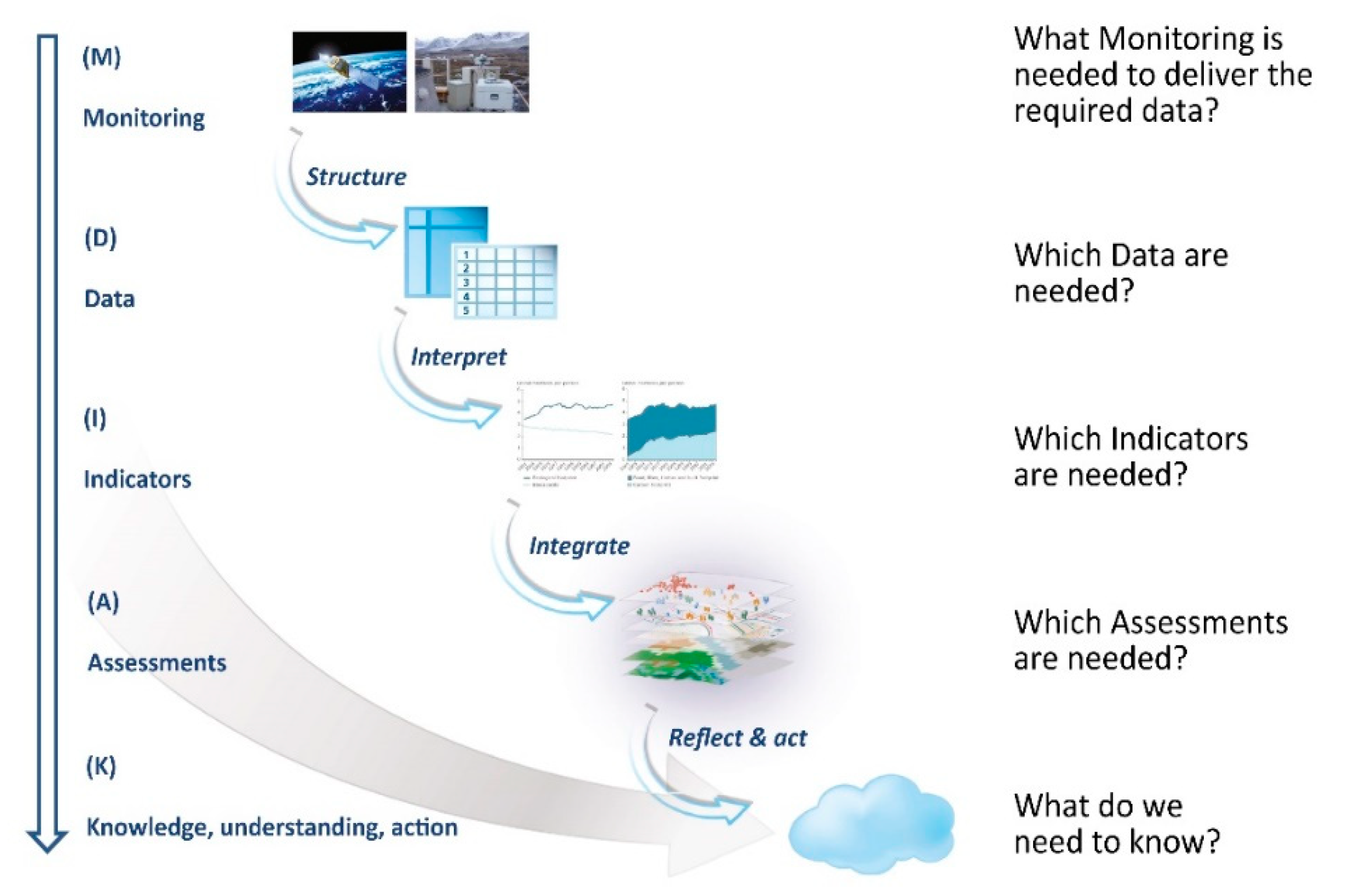
2]. Then, we consider the use of technical solutions for enhanced and cohesive decision and planning support. We mainly build our understanding on years of studies and experience. This is gained from existing hydrogeological models and monitoring projects in the Danish municipality of Odense, along with the selected ‘sustainability’ indicator (e.g., depth to shallow groundwater table), elaboration of a monitoring strategy, and the consequences tolerated for individual indicators inspired by the Monitor–Data–Indicator–Assess–Knowledge chain (MDIAK) (see
Figure 1, modified after The European Environmental Agency (EEA), [
15]). Furthermore, we build on the understanding of the person–community–infrastructure–institutional societal resilience framework developed in NORDRESS [
7,
8] in order to minimize risks from hazards and integrate scientific knowledge.
Odense City is used as example. Odense City has a risk of impacts from man-made activity and, due to its position near the bottom of Odense River catchment and the coast, it is at risk of groundwater flooding, surface-water flooding, and raised sea-level. This implies, associated with climate change modifications, that there is an increased possibility of areas with various coinciding hazards.
2. Analysis of Natural and Man-Made Processes in Regard to Urban Studies
To be able to perform knowledge-based decisions in urban planning, all important natural and anthropogenic processes must be taken into account. These processes have to be characterized and analyzed if their impacts are costly or represent a threat to health, cultural heritage, or ecosystems.
Key elements that have to be considered include climate, the water cycle, and natural and man-induced hazards.
Table 1 compares the size and extension of natural and man-made hazards in the urban landscape. In addition, common relationships between the climate and man-made impacts have to be studied. The use of data, modelling, and monitoring have to be considered for improved planning and management.
2.1. Natural Hydrological Processes Impacting Urban Freshwater Cycle
The hydrological cycle is based on an equilibrium state between precipitation, evaporation, surface runoff, infiltration, and groundwater flow. Any modification in the hydrological catchment results in changes towards a new state of equilibrium. Precipitation, wind, and temperature are important meteorological drivers of the hydrological cycle that have to be considered. In Denmark, increasing precipitation has been observed within the last century and further climate changes are predicted in years to come that will increase water levels, facilitate cloudbursts with floods, and produce dryer summers with droughts. Moreover, a rise in sea level is expected.
Increased precipitation intensity can nearly instantaneous induce streamflow alterations but no corresponding impact on groundwater is detected. Whereas, long-lasting meteorological events, such as droughts or wet seasons, can be associated by similar changes in groundwater levels identified by the regional monitoring and need to be taken into account in urban planning.
2.2. Geological Processes in Urban Areas
The landscape form and ground permeability of near-surface layers largely control runoff and infiltration. A terrain characterized by steep slopes combined with high clay content in the upper soil layers usually results in a large amount of surface runoff. On the contrary, infiltration into the ground increases, if the land-slope is gentle and near-surface layers have a higher permeability. Thus, geological mapping provides important knowledge for the characterization of an area (See
Table 1 and
Table 2).
Urban geology drastically influences city development, as well as its freshwater cycle [
4] (pp. 39–41). Within the urban subsurface, the occurrence of even smaller thicknesses of organic deposits or sensitive clays can cause geotechnical problems for the foundations of buildings and cultural heritage. Such problems increase with changes in the groundwater level, as can be seen in e.g., Denmark and The Netherlands. Another example, relating to some of the Mediterranean countries, is tectonic and volcanic activity released forces resulting in uplift, changing flow directions in streams and aquifers.
2.3. Anthropogenic Deposits Resulting from Urban Evolution
Urban anthropogenic deposits are a consequence of urban growth, land-use changes, and technological development. These deposits consist of buildings, bricks, pipes, tunnels and fills and they reflect anthropogenic history. These deposits need to be judiciously studied as they impact traditional hydrogeological modelling. To understand and interpret urban geology, it is necessary to include a mapping procedure for the anthropogenic elements, and the developments over time [
17] have to be taken into consideration. For example, the vast majority of Danish cities have developed in the past 200 years (see
Table 3). Consequently, the city center will have a sequence of subsurface layering affected by all historical activities, while only recent ones will occur in the youngest parts of the city.
Man-made activities are able to affect groundwater levels, superficial groundwater runoff, and surface runoff. In
Table 4, examples of man-made urban impacts affecting the hydrological cycle within the last 200 years are summarized and classified. In addition to the originally targeted purpose of constructions, unwanted and often unforeseen impacts can also occur (e.g., blocking and intersection of aquifer flow [
18,
19]). Lowering of the groundwater tables can result, simultaneously with declining groundwater quality due to infiltration from contaminated sources—for example, in Odense [
20,
21] and Copenhagen [
20,
21,
22,
23] pollution from surface water and saltwater intrusion, have occurred, and pyrite-oxidation with increased sulphate concentrations in groundwater related to the unsustainable drawdown of groundwater levels near wellfields [
22,
23]. Furthermore, lowering of the water table in several cities has resulted in a compaction of the subsurface, inducing a land subsidence as a result (e.g., in Shanghai [
24]). Stopping or reducing groundwater abstraction can result in groundwater level and quality changes, as has been seen in Odense [
20,
25].
The land surface near shallow groundwater stratum can also be affected by regulation of ditches and watercourses, which affect surface runoff. Abstraction in the upper end of the catchment can affect runoff in the summer seasons, which will be of special importance for the ecosystems.
2.4. Climatic Impacts on the Hydrogeological Catchment Related to Anthropogenic Activity
When considering the effect of man-made activities in a catchment, it is also necessary to include the impact of expected climate change. Climate changes can result in a change of sea level due to melting polar ice, and modifications of the precipitation and evapotranspiration regimes in terms of quantity and distribution. Identification of potential impacts on existing buildings, cultural heritage areas and ecosystems is the main focus of climatic-change studies It is important to provide a common understanding of the likelihood of impacts from other man-made processes. Mitigation and adaptation will typically require a coherent sequence of assessments in order to clarify:
Where in the catchment climate change will have an (unacceptable) effect on surface runoff and groundwater levels?
Where is it technically possible to reduce and delay these unacceptable impacts?
Where in the catchment should potential adaptation and mitigation solutions have an acceptable influence on groundwater levels and surface runoff?
In Denmark, implementation of SuDS (Sustainable Drainage Systems) is commonly used to separate rainwater from grey water. The challenge of using SuDS in these areas is to infiltrate excess water into the subsurface. If infiltration is possible, it must be checked that raising groundwater levels in the infiltration area and surrounding land are acceptable. An example is Vinkælderrenden/Skibhuskvarteret in Odense; after a detailed mapping and hydrological modelling, it was realized that the groundwater level elevated unacceptably in the neighboring areas. Therefore, an alternative solution had to be found.
2.5. Influences of Human Settlements
For millennia, our ancestors have accessed water bodies for drinking water, fishing, and easy transport. Many cities were, therefore, founded near rivers and near the coastline, and thus at the bottom of hydrological catchments. Activities in the entire upstream catchment thus require consideration, with its boundary often situated at considerable distance from the city and its peri-urban areas—because man-made activities at the top end of the catchment can have downstream impacts. The management of rural areas situated upstream of cities is usually done with a different perspective with agriculture being the main focus. In general terms, the draining of agricultural land, watercourse straightening, and crop cutting, together with increasing paved areas, all tend to increase surface runoff and flood risk in downstream urban areas. Extreme flooding events are expected to increase with predicted climate change with more warm and wet winters, and more intense cloudburst events in the summer. A further complication arises, when catchment areas cross authority boundaries and the management of these upstream areas is the responsibility of another authority. Thus, the management structure and relative position of a city and its boundaries are of importance for determining resilience and sustainability.
2.6. Essential Added Knowledge for City Management and Planning
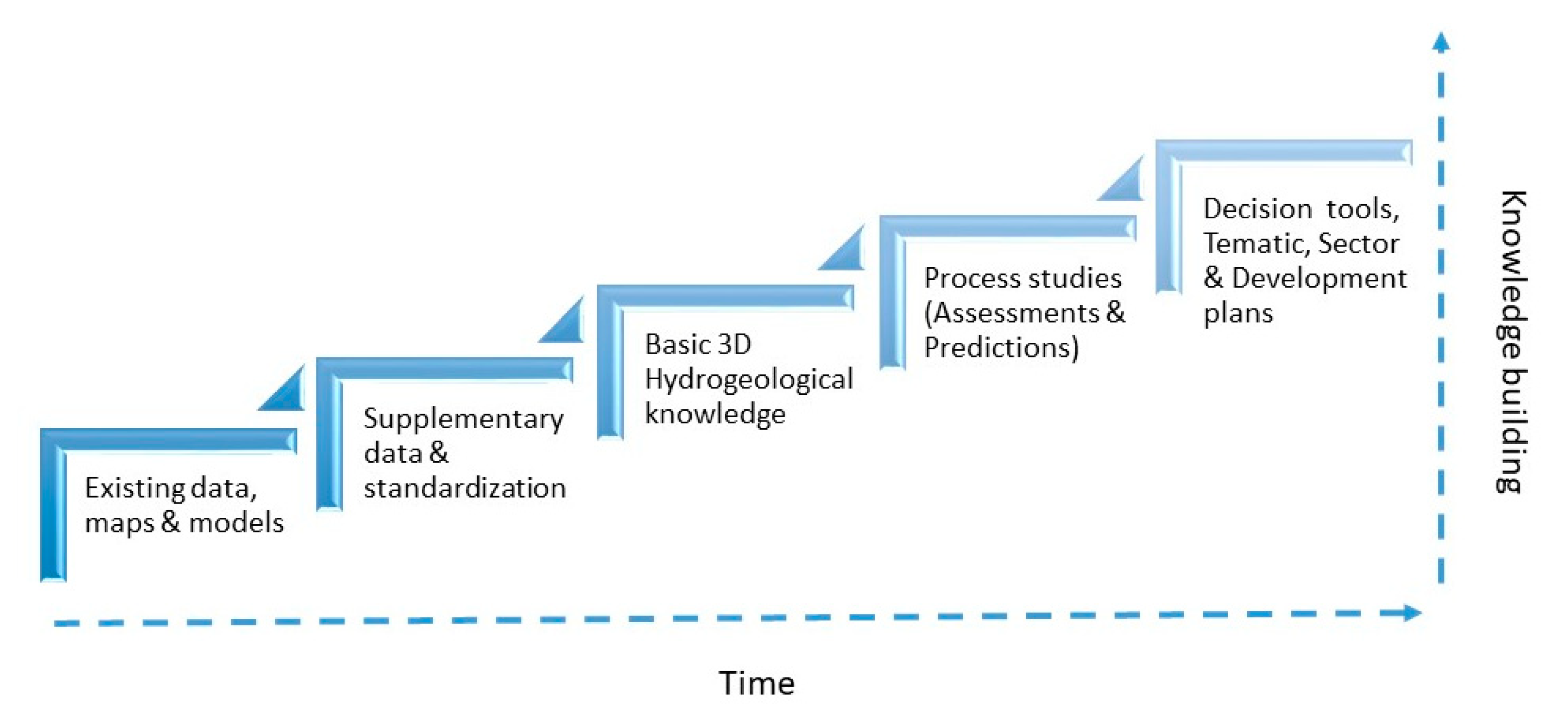
Traditionally, urban planning and management have been based on thematic maps containing information about constructions, infrastructure, occupation, and land-use. Since urban areas also have a buried infrastructure (cultural and archaeological sites, subsurface constructions etc.), such topics as aquatic ecosystems, aquifer vulnerability, thermal and mineral resources, ground stability, and waste disposal all require hydrogeological consideration for hazard identification and risk management. For hydrogeological planning and management purposes, there is a need for a regularly repeated process (for each planning period) that also includes relevant urban issues, rather than site-specific projects covering only one specific problem. There is a need for stepwise knowledge building—starting with: existing maps and data sets, new data capture and data collation, and basic hydrogeological model building, assessments, and use of knowledge in planning (
Figure 2). This requires building relevant and conceptualized information—for example, temporal and geographical scale, history, demography, infrastructure, land-use, and hydrogeology—to be represented in three dimensions and visualized with integrated GIS at a higher level than previously.
The process contributes to a large amount of data and flexible use of selected information is needed in order to avoid starting over again whenever new situations arise. Thus, there is a need to determine which information should be made digitally available, and how this can be performed by which digital processes. The evaluation of existing, digitally-available hydrogeological data and models from previous studies, and the evaluation of supplementary data, are important parts of the analytical process and working methods for determining increased resilience and sustainability.
Urban management and planning, involving natural and anthropogenic processes requires a systemic focus on the following data:
Basic hydrogeological information system (including climate, hydrogeology, surface-water catchment and sea level, and potential changes to them);
Drinking water-supply and waste water plans;
Urban infrastructure and environment (including issues to support infrastructure development, cultural, and environmental risk assessment);
Planning hierarchy and its management.
What is important is that urban management and planning activities require a good understanding of current hydrogeological and hydrological conditions, a good comprehension of their evolution over a long time, and a reliable estimation on the consequences of potential changes expressed in terms of modelling scenarios. It involves natural and anthropogenic processes from two viewpoints, contributing to greater resilience and sustainability:
A geoscientific urban perspective that includes new model building, monitoring, and assessment;
An adaptive planning and governance perspective that handles the necessary information and its correct use.
3. Hydrogeology in Odense (Denmark)—Methods of Mapping and Assessment
Odense Municipality (Denmark) is a good basis for a practice example, since the water supply, the municipality, and the former county authority (the Danish counties were closed in 2007 as a result of a local (municipalities) and regional (counties) governmental reform) have had a long tradition of data collection and groundwater mapping. Therefore, data and experience are available for further knowledge building.
3.1. Subsurface Mapping and Assessments
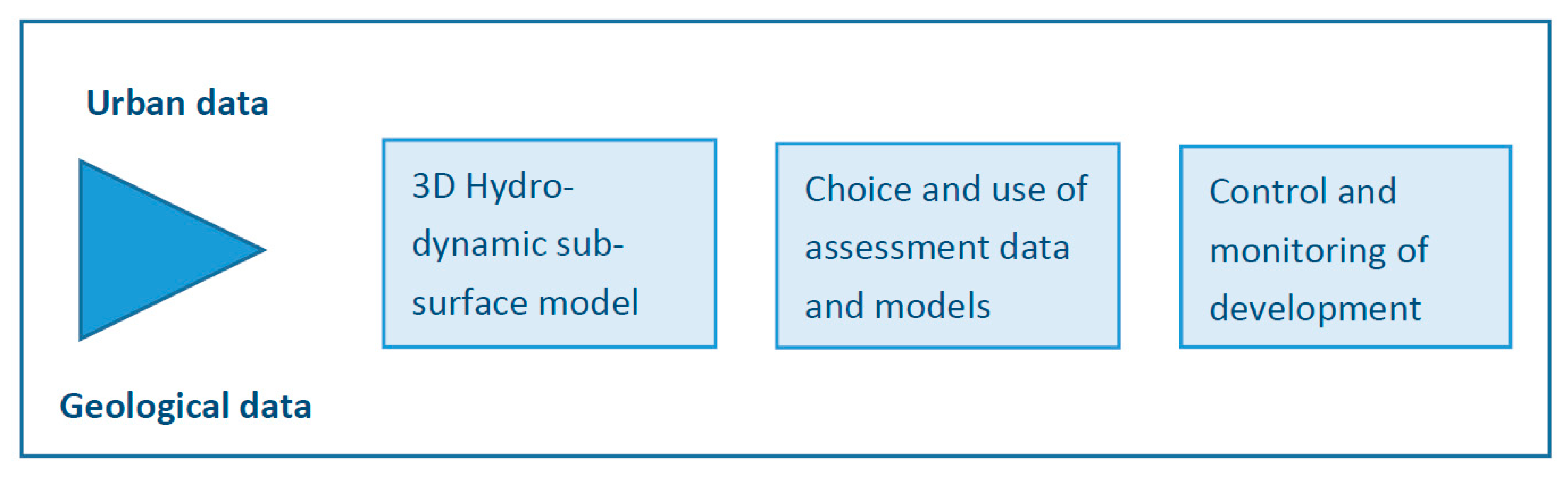
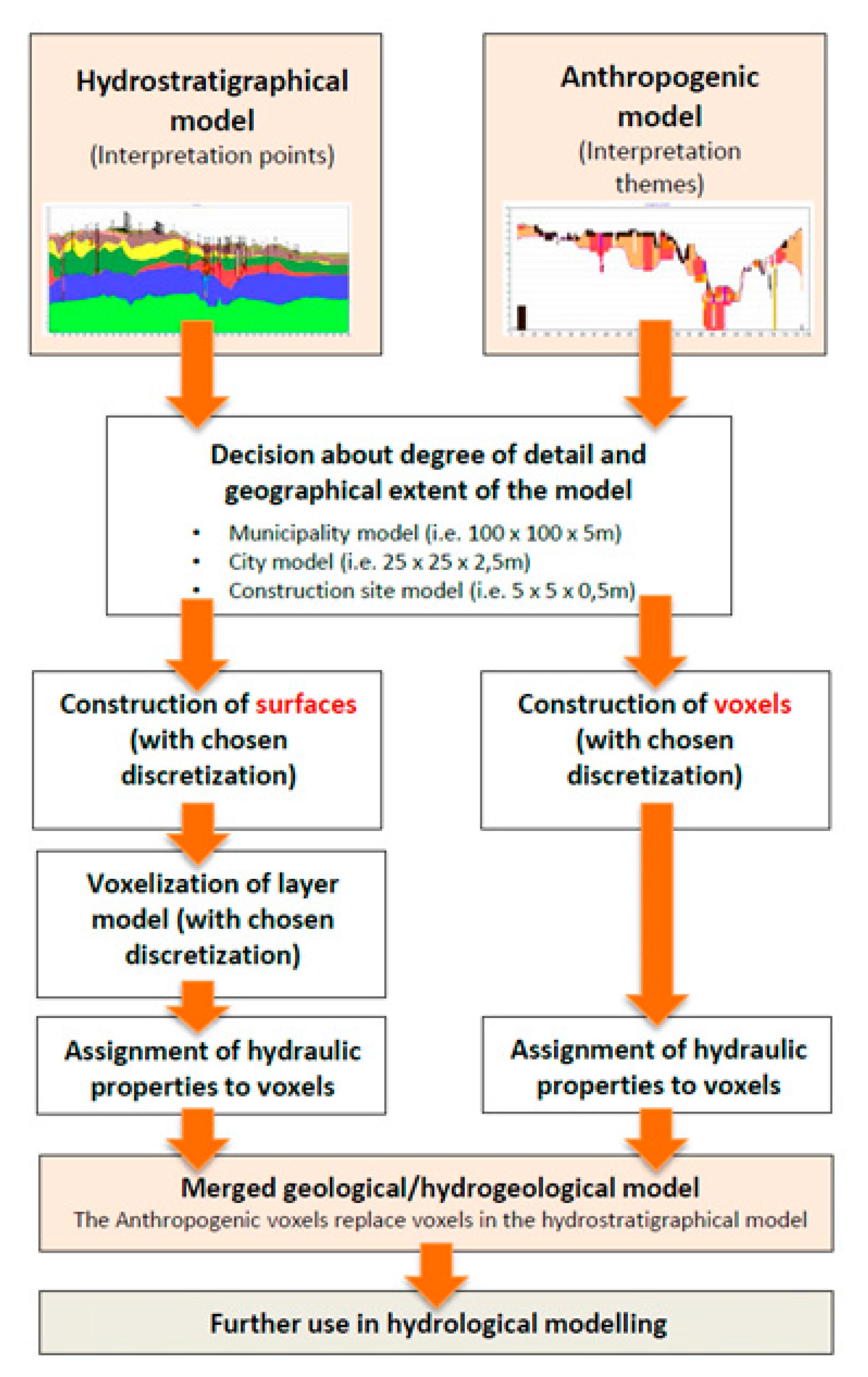
It is important to use a robust hydrodynamic subsurface model (anthropogenic and geological) and relatable time series that can define indicators to assess the groundwater dynamics of selected aquifers. One of the keys to replicable scientific work in Odense is using common public databases with relevant, standardized, and correct datasets that are easy to access. This ensures that the same basis for decision-making and for information updating are used. The foundation for this work was the development of a ‘new’ city-scale 3D geological and hydrogeological model that provides a coherent and updated basis for the urban water cycle analysis and for management of the urban subsurface.
Depending on the specific situation, one must select hydraulic assessment models that are built on these datasets (see
Figure 1). The connection with the work performed in knowledge-building (from data collation to hydrodynamic model) is important for the following hydrological assessments and monitoring. Dealing with hydrogeological modelling we differentiate between existing project situations and a new municipality model with a year-by-year updating.
Figure 3 illustrates the four steps consisting of Subsurface data, Hydrodynamic subsurface modelling, Hydrological assessment and Monitoring.
Requirements of a City Scale Concept Hydrodynamic Model Framework
First, a city-scale concept is required to allow the combination of anthropogenic and hydrogeological information. It is essential that the modelling, in selected areas, is based on detailed knowledge of natural and man-made processes and their potential impacts. When the modelling of subsurface knowledge is extended to the entire municipality systematic mapping rather than a project-based approach is mandatory. This is a cross-disciplinary process with several challenges:
The established hydrogeological model is based on heterogeneous information from the existing boreholes, geophysics, maps, and models of varying quality and age;
The anthropogenic man-made deposits beneath the cities differs in age, scale and origin from geological deposits. Collation of data and modelling on anthropogenic deposits are related to the urban history and deviates very much from hydrogeological processes;
A workflow for interlinking and merging different kinds of models has to be designed;
A definition of due care in regard of the maintenance of the modelling is necessary, and has to be defined from the outset;
A design of information output has to be defined.
3.2. Development of ‘New’ City Scale Hydrogeological 3D-Model
In Odense, the national geological survey, the municipality, and the local water utility found in 2012 that most geological and hydrogeological mappings was in rural areas, but similar activity for the urban areas was lacking. Thus, a goal was established to produce one model at a municipality or city scale, which, through sustained maintenance and development, could be improved year-on-year with the introduction of new geological and hydrogeological data and information on anthropogenic changes. The focus was put on groundwater and surface water, the connection between deep and shallow aquifers, the secure use of existing models all relevant data, large-scale overview mapping, and detailed small-scale mapping, and based on the selected typical work situations (see
Table 5 and
Figure 4). A hydrogeological 3D municipality model project was established through a pilot study (‘Development of a 3D Geological/Hydrogeological model as basis for the urban water cycle’ [
25,
26,
27,
28,
29,
30,
31]). The pilot-project was completed in 2015 with a report [
25,
26,
27,
28,
29,
30,
31], and the developed model was selected as one of the examples of good practice of urban modelling by the European COST Action TU1206 Sub-Urban project ([
6,
32] (pp. 64–74)).
The following four case-studies illustrate several important technical aspects for the Odense urban subsurface and hydrogeological model:
The
first case-study focuses on the design of a hydrodynamic model area for the entire municipality level area and some separate detailed areas. Analysis has been performed on the current and potential planning and management activities (see
Table 5) that were compared with existing data and models. The analyses searched for optimal solutions. This model should be able to operate on a municipal level and in selected areas (constructions and up to city-quarter, see
Table 2) with a detailed discretization. Consequently, the Municipality model had to be built on existing digitized data and include the following elements: deep and shallow aquifers, deep and shallow geology, man-made deposits, and constructions.
Figure 5 shows a view of the resultant conceptual model.
The
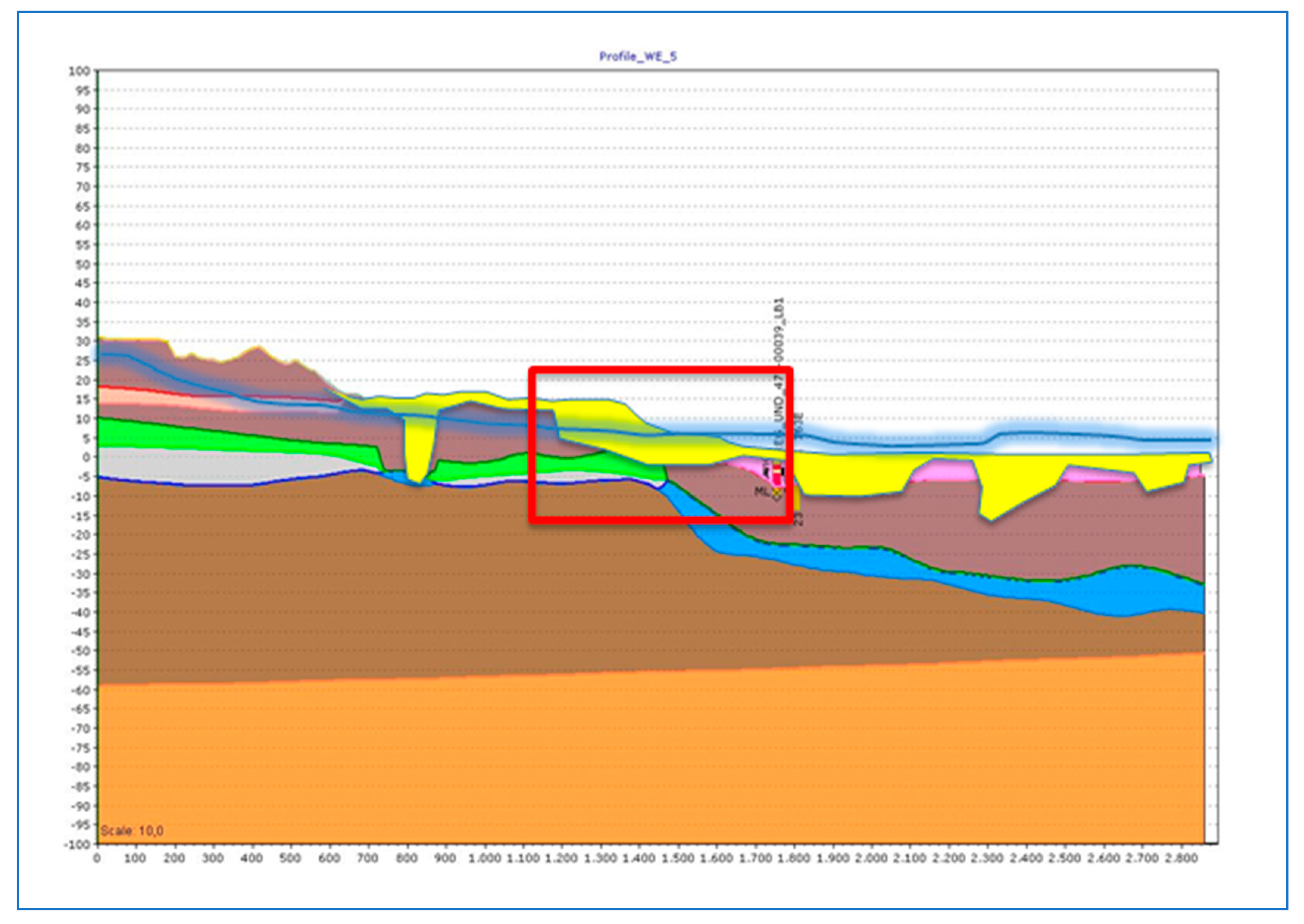
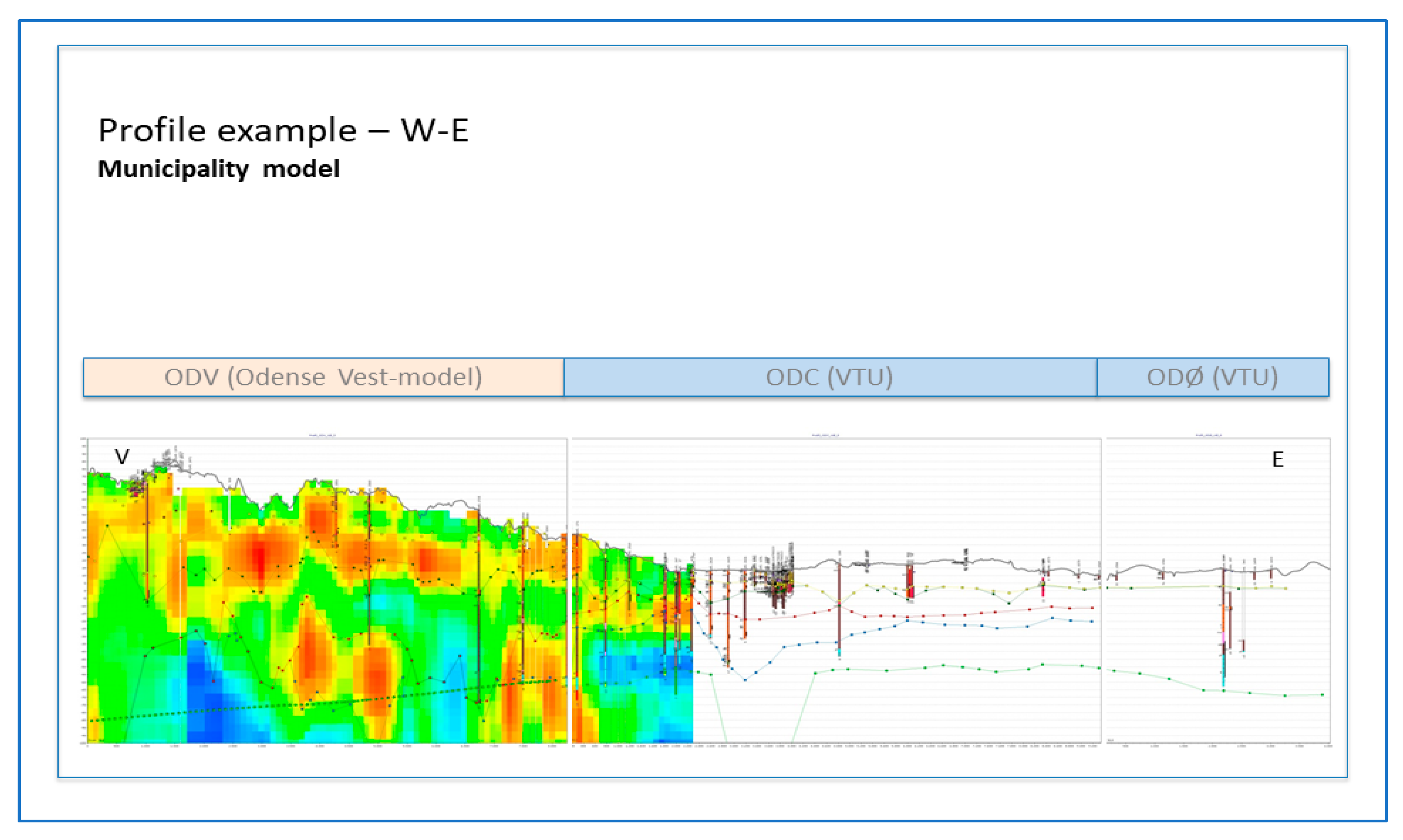
second case-study focuses on hydrogeological modelling beneath cities. The existing data from Odense city revealed areas with only limited or old data (see
Figure 6). The lack of sufficient site-specific data [
33] caused difficulty in making sound decision-making and assessing uncertainty, and led to the need for gathering supplementary data. The operation of assembling data, especially of geotechnical and cadastral types, proved to be time consuming, and data updating and modelling required professional administrative governance.
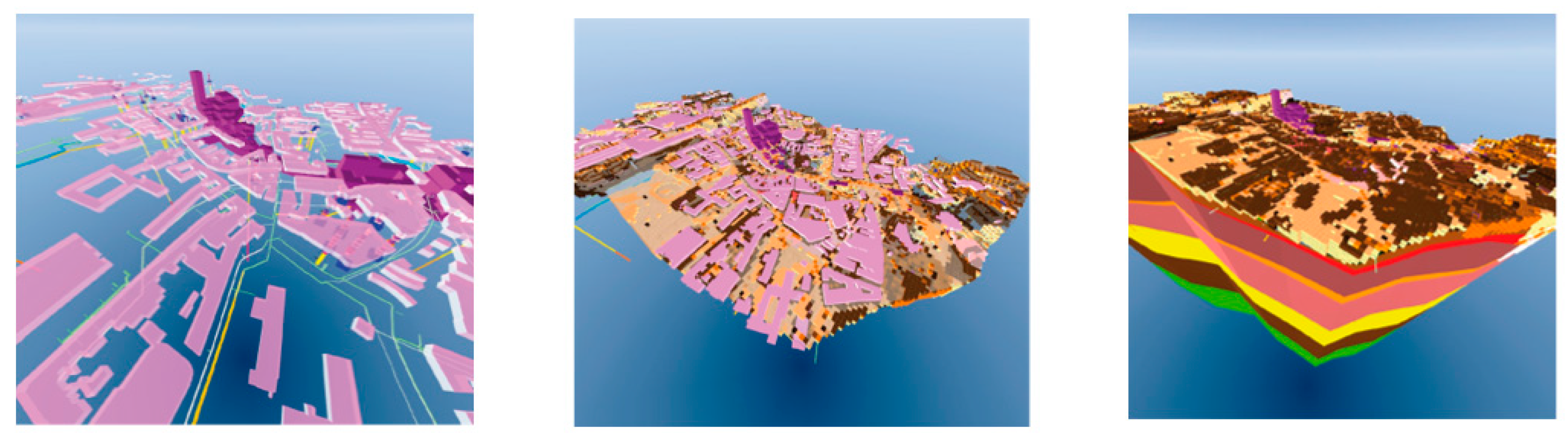
Modelling of the urban anthropogenic layer represents the third case-study. This layer consists of bricks, buildings, constructions, pipes, roads, excavations, urban fill, and many other materials of different age. The modelling process includes cadastral data coming from the municipality, data characterizing the sewer system and water supply network (from the local water utility, VCS Denmark), as well as borehole logs and geophysical surveys (from GEUS and VCS Denmark).
The information is frequently updated as result of urban dynamics. A rule based data handling procedure was chosen to process and update systematically the huge amount of data—GeoScene3D Software (
www.GeoScene3D.com) being selected for data processing. Finally, a detailed voxel model for the anthropogenic layer of the Thomas B. Thrigesgade (Odense City) has been obtained, which is illustrated in
Figure 7.
Defining the procedure of working with different models and model scales stays as the
fourth case-study. Urban modelling often requires the use of information from other sources in order to augment model information or regional trends. To combine geological models and anthropogenic models a common workflow is required.
Figure 8 illustrates the anthropogenic data, the resulting anthropogenic layer and the combined anthropogenic-geological model.
Figure 9 shows a workflow for merging a municipality model and a detailed anthropogenic model.
3.3. ‘New’ Approach for Monitoring Groundwater Levels in Odense
Monitoring of shallow groundwater levels offers important information in urban hydrogeological studies, especially if they are part of long time-series. The monitoring data can offer a valuable picture of the spatial and temporal evolution of groundwater levels and urban groundwater dynamics. The monitoring of complementary parameters, such as water temperature and quality, can offer valuable additional knowledge.
In Denmark, observation of groundwater levels mainly takes place in three types of monitoring wells. At the national level, monitoring is normally performed in boreholes outside urban areas and is used to study natural processes (e.g., changes in winter net precipitation on groundwater level) in areas that are not affected by abstraction and other man-made influences. The second level relates to licenses for groundwater abstraction, and the monitoring wells are situated near wellfields. Finally, the third level relates to the collation of additional data for hydrogeological surveys, for example for detailed modelling of groundwater levels due to the infiltration of excess rainwater (as seen in Vinkælderrenden in Odense) [
34]. Groundwater monitoring for the preservation of ecosystems, and the cultural heritage is not a standard procedure.
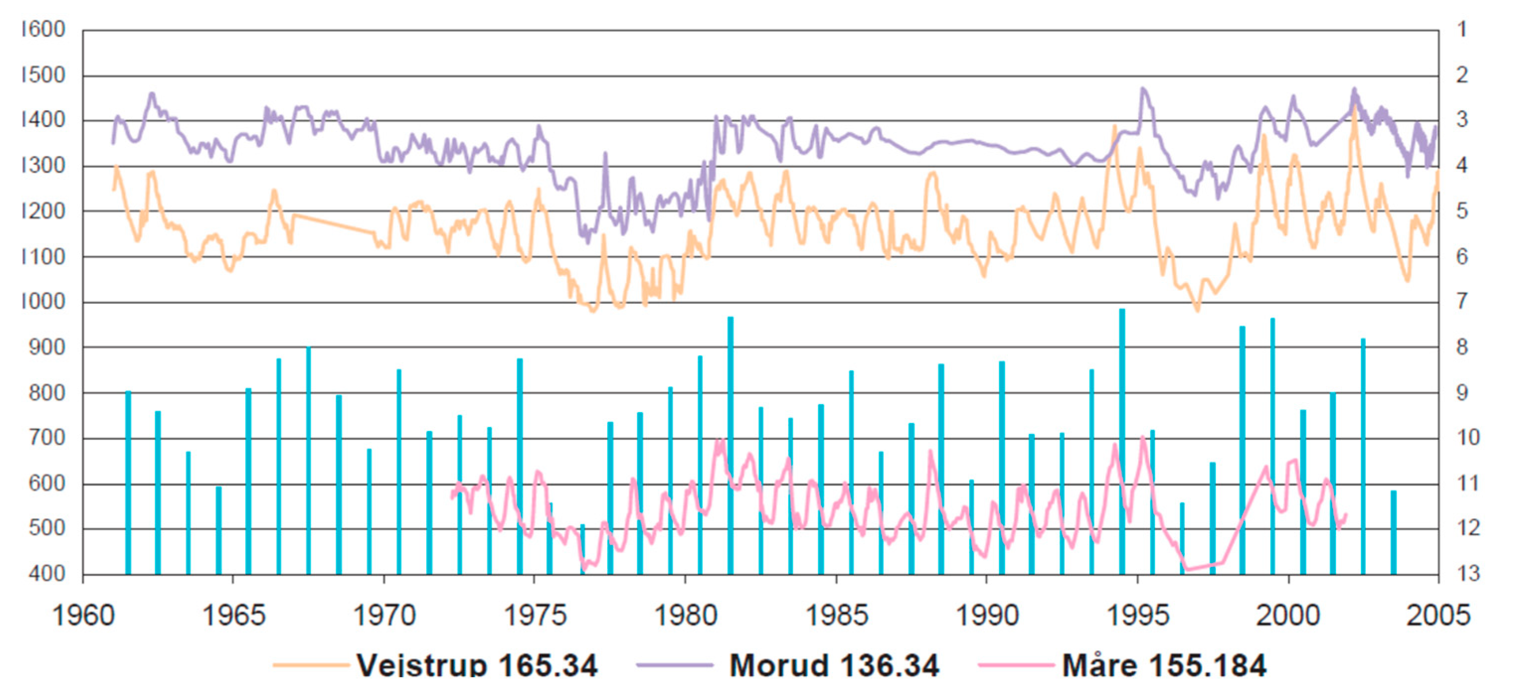
In Odense City, comprehensive monitoring networks, which were established in the mid-1960s for wellfields, were later abandoned. Today, this information would have been useful for detailed urban studies, but a valuable picture of the evolution of groundwater levels since the 1950s is given by the national monitoring system (See
Figure 10).
Earlier urban monitoring focused on the impacts of groundwater abstraction on neighboring wells and drinking water quality, but today there is a tendency to focus on the impacts of changes in groundwater abstraction patterns and their impacts of subsurface constructions and infrastructure.
The frequency of monitoring in national monitoring wells has been improved in time. In early days, this monitoring was performed by discrete observations (just a few times per year) but this was later improved to monthly readings, and today, data-loggers measure groundwater levels remotely up to several times a day (for studying the relation between shallow aquifers water-level and wetlands).
3.4. Urban Groundwater Studies on the Interaction of Hydrological Events
A master study of the Nordic Centre of Excellence on Resilience and Societal Security (NORDRESS) [
36] illustrated that the forced infiltration of rain-water from paved areas (as investigated in Skibhuskvarteret), leads to a marked increase in groundwater levels close to the infiltration basins. The local geology appears to exert a major influence on this phenomenon, since high hydraulic conductivity is needed to ‘spread’ the infiltrated water. Increases of groundwater level of up to 1 m, are modelled in the Odense area due to increased winter precipitation, and an increased sea-level of a similar magnitude occurs near the Odense River and Fjord (due to global warming and sea level rise and storm surges), which challenges water management activities for climate change adaptation and risk reduction.
Another NORDRESS master study [
37] evaluated previous assessments of Odense flooding risks and established that without adaptation work, flood damage at Odense will increase from 3.9 million of Danish kroners in 2010 to 9.3 million of Danish kroners by 2100. The study [
37] revealed a projection of 239 million of Danish kroners for the expected increase in damage costs resulting from climate change by the year 2100 and highlighted the need for a cost–benefit analysis of potential adaptation options.
The need for adaptation is further challenged by the expected increase of maximum runoff of the Odense River. Several reports [
37,
38] suggest a 40% increase in the daily maximum 100-year return period runoff event in Odense River by year 2100. The NORDRESS study [
37] highlighted that the inundation resulting from concurrent events from storm surges and river flooding could result in damage costs of some 833 million of Danish kroners for publically owned properties. This does not include critical infrastructure damage costs nor the potential interruption of commerce due to inaccessibility.
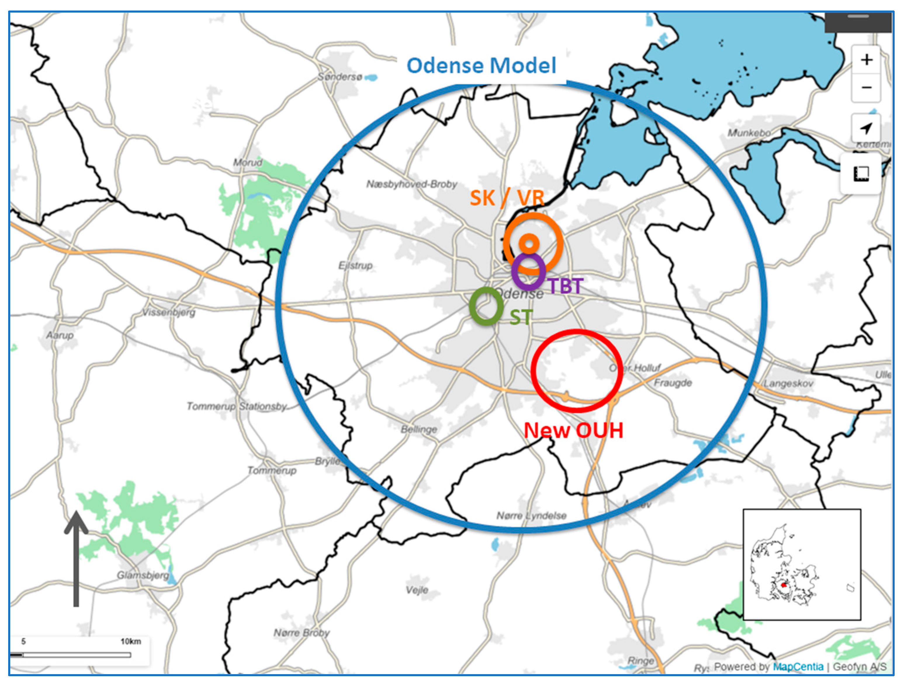
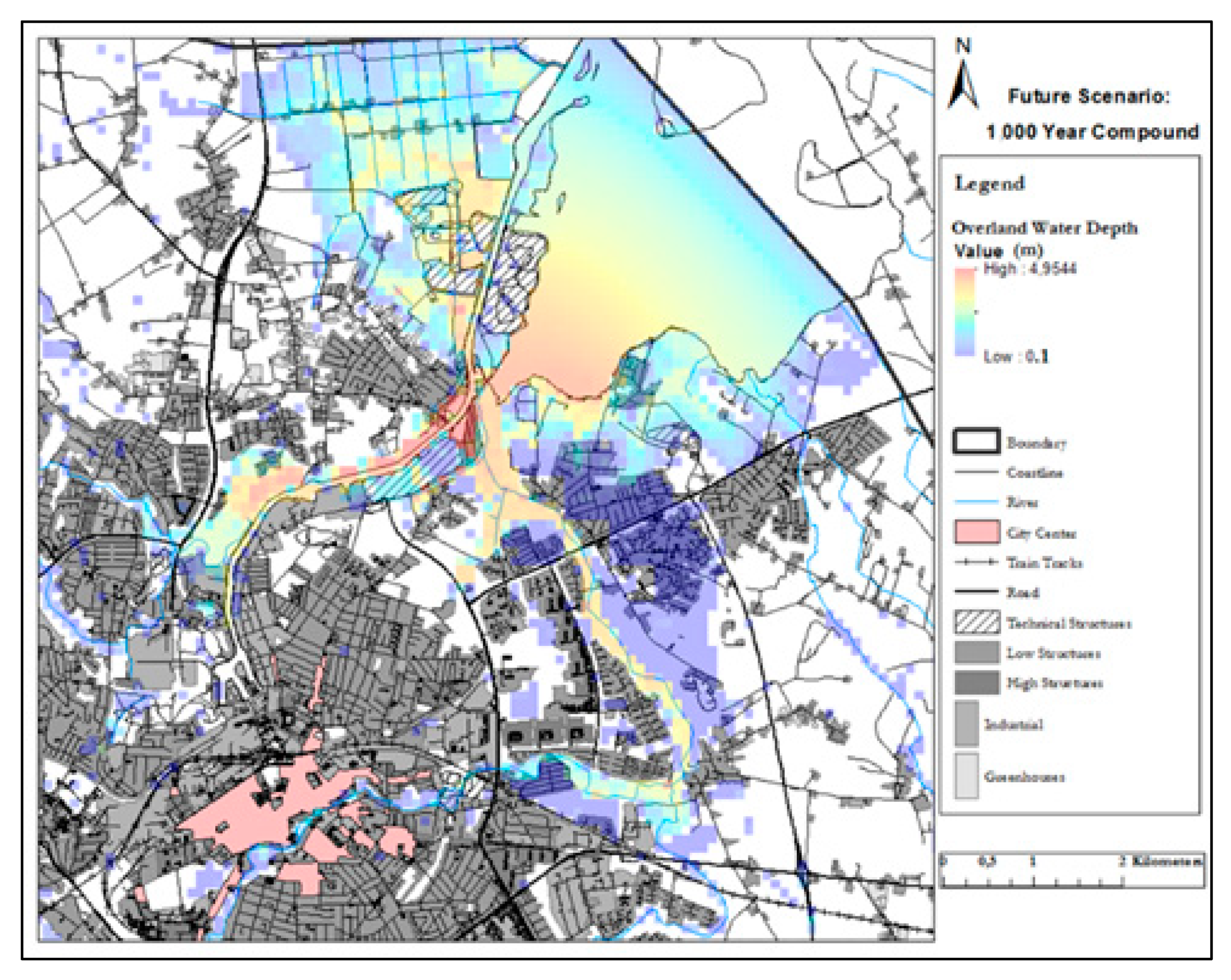
In Odense (
Figure 11 [
37]), the interacting impacts from different hazards are important for urban planning strategy. It is critical to manage disaster risk reduction, climate change adaptation, and water-supply security in an integrated and adaptive way.
3.5. ‘New’ Concept of Adaptive Planning and Governance
Classical modes of planning were grounded in rationalistic, authoritarian planning model where politically described goals were translated into plans implemented by the administration. Contrary, to this adaptive planning and governance is grounded in neo-institutionalism, social-science based approaches which consider governance, collective action, informal rules and the redefinition of spatial planning toward “place” governance. Instead of focus on scientific-rational development plans, in the new concept, focus is on communicative determination of needs, the joint development of plans in participatory processes and the activation of citizens to participate in spatial planning [
39]. Adaptive planning and governance therefore focus on polycentric governance e.g., cross-sectoral and multi-level coordination with focus on learning capacity and adaptability of plans and actor networks. The main advantage of the new concept compared to the old classical mode of planning is that it enhances adaptability and capacity for self-organization and learning [
40]. Learning here is understood in different types e.g., reflexive social learning, instrumental, political, and symbolic learning [
39] which can be regrouped into institutional and individual learning [
41].
As in many other cities, Odense has an increasing need to use its subsurface efficiently, in order to balance conflicting uses and avoid natural and man-made hazards, reduce the likelihood of future climate change risk, and to safeguard its ecosystem services. The city needs to be able to adapt, plan and manage according to transparent governance principles at the water catchment, city, and street dimensions. This means that adaptation plans and measures should be prepared, implemented, and followed-up regularly [
11]. City management cannot wait for additional measuring, collating, and processing fundamental information before acting. Thus, leadership is important. From the outset, this work must be systematic and well described to a level fit-for-purpose.
3.5.1. Towards a More Resilient and Sustainable Urban Area
In Odense [
21,
25], historical development has illustrated on several occasions the consequences of man-made activities years previous, which were unforeseen or negative.
In the COST Action TU1206 Sub-Urban Project [
42], it was important to make a correct inventory of problems (screening the problem to solve it), to have proper mapping (screening of required data and processes), and then to be able to make use of this mapping. Thus, hydrogeological and geological characterization had to be based on geoscientific skills and expertise with a focus oriented towards the required scale, depth, land-use, and timing, with upscaling of the expected impacts on surface-water and groundwater. Planning and management had to be based on mapping of the history of urban development, as well of its geology.
3.5.2. Strategic Elements for Management of Urban Subsurface
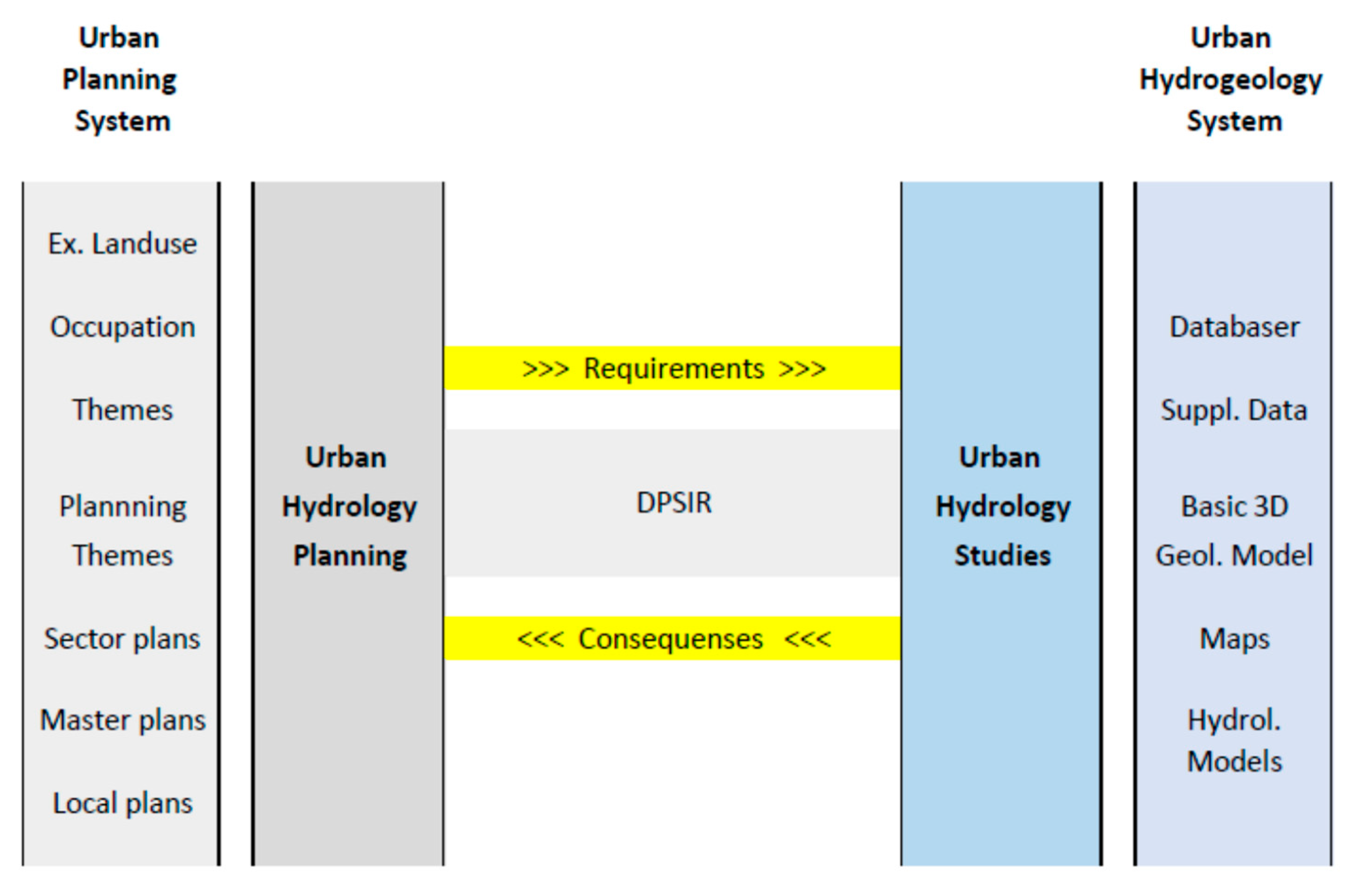
The strategic elements in the European Environmental Agency’s Monitor-Data-Indicator-Assess-Knowledge (EEA MDIAK) decision chain are given in
Figure 1. This contains useful tools for integration and management of the urban subsurface. Focus is put on parts of planning, modelling, monitoring, and mapping that deviate from traditional hydrogeological techniques for rural areas—and they include city planning (construction, city quarter, city landscape, metropole, and state), the planning of a drinking water-supply (well–field and local abstraction, and future development), and integrated resource planning.
Modelling enables us to study the relevant processes and forecast the consequences for the environmental planning. Relevant issues and data must be integrated to a level that fit the individual case of each area, as no model fits all cases. The catchment scale must be decided upon, since models need to be very detailed for urban areas (e.g., for modelling constructions and city quarters). The coherence between hydrogeological modelling, hydrological modelling, and monitoring is important because their methodologies complement each other.
It is not possible to manage properly if there are too few data compared to problems solved. Therefore, monitoring is the first important step towards achieving a more resilient and sustainable urban area. For example, it is necessary to study, for dry summers, how and when the processes evolve and register their impacts (
Figure 1). Selected parameters have to be mapped in terms of their time of appearance, frequency and duration, and size. Choice of the limiting value for each indicator is important. Monitoring is thus a key issue for management [
43,
44,
45,
46,
47].
3.5.3. Operationalizing Resilience
An investigation of social resilience in the NORDIC countries, including Denmark [
8] shows that there is a general focus on the co-production of knowledge, with an emphasis on mapping resilience, producing territorial level indicators of adaptive capacity, vulnerability, and social learning as part of good and transparent governance. These factors can facilitate adaptive urban design and resilience to natural hazards by allowing flexible responses and adaptation to changing contexts, and acting as potential drivers for increased societal resilience.
Enhanced information sharing at the local, national, international and cross-border levels were identified to facilitate information sharing [
8]. However, dealing with uncertainty and especially ambiguity as part of knowledge co-production is still in its infancy. This means that that there is not yet full acknowledgement of subjectivity and proportionality, and there are multiple ways of knowing, especially when it comes to handling emergent groundwater management challenges. In many smaller Danish municipalities with only one or few persons dealing with groundwater management (and because municipalities are the authority responsible for climate change adaptation and urban planning [
47]), co-production capacity may be limited.
As part of environmental governance, and as described with these examples from Odense, adaptive planning and governance of the urban subsurface and water resources need to be coordinated with the other types of planning, e.g., ecosystems, infrastructure, housing, cultural heritage protection, etc. This is especially in order to address the environmental challenges and problems at hand, which are often wicked or complex and thus has a very high degree of uncertainty. Furthermore, similar to spatial planning projects or adaptive measures dealing with environmental issues, such require policy responses that are cross-sectoral, rethinking of norms, territories (or places), and policy levels.
3.6. Use of Data Outcomes
A nationwide comprehensive groundwater mapping (in years 1998–2015) based on airborne geophysical surveys, boreholes, mathematical/physical groundwater models, chemical analyses, etc., were performed as basis for local action plans for protecting the drinking water resources. The collated data and results contribute to the national hydrogeological databases and is used as valuable 3D hydrogeological input to the nationwide water resource model, DK-model [
48,
49,
50].
The proposed workflows in this paper are based on comprehensive data collations and 3D modelling exercises that are not dealt with earlier. Besides, the work processes also generate a considerable amount of data to be synthesized in the strategic planning and decision-management. For this purpose, automatized data handling with the use of indicators, remote sensing, modelling, and monitoring ease the access to visualizing valuable information in the urban area and its subsurface.
As described earlier (e.g., in
Section 2) urban areas require more detailed and exact mapping due to more intensive land use and impacts on the hydrogeological catchment. Typically, in urban planning and management purposes we are looking for places suitable for specific land-use/cover characteristics such as nature based solutions (e.g., extended green/blue areas), areas with negative impacts due to man-made or natural induced hazards or results of combined land-use just causing a negative evolution.
Typical indications for critical impacts are unwanted changes in land-use/cover or terrain levels, unwanted changes in groundwater level or groundwater depth below terrain, or unwanted changes of the frequency of flooding. Mapping of change detection can be based on results of assessments or monitoring of groundwater levels in boreholes, but it can also be detection of changes in specific features in cartographic maps, geophysical or satellite information, etc.
The synthesizing of outcomes can be performed as a part of the data collation, as satellite land-use/landcover mapping, as change detection on land/geology and as a mapping of the impacts on the groundwater or surface-water. GIS-suitability analysis (or impact analysis) exploits unacceptable and acceptable differences between normal and changed situation. A part of this analysis is weighted overlay of GIS-layers.
4. Results
This paper focuses on the urban hydrogeological studies that have to be implemented in the activity of cities planning, decision making and management in order systematically to support their resilience and sustainability. Besides focus is on improvement of the following topics: assessment of sustainability and resilience, the importance of subsurface conditions, hydrogeological/hydrological conditions and the need of comprehensive planning.
4.1. Natural and Man-Made Processes
The meaning of using sound knowledge of subsurface conditions is clear. The freshwater cycle with all its components and external influences plays an important role in decision-making. The location, amount, density, and spatial and temporal scales (
Table 1,
Table 2,
Table 3 and
Table 4) highlight how much natural and man-made environments have changed and their impact.
In Odense, observations during the last few hundred years show a strong anthropogenic influence on the natural water system in urban areas, whose consequences are first understood many years after their implementation [
25]. It is also observed that the effect of non-governed actions (groundwater abstractions, drainage, piping, infrastructures, etc.) likewise influence the hydrological system. These actions initially individually seem to be small or unimportant, but over a time-span of years, it is realized that they amount to a significant impact.
Improved quality and access to information improves urban hydrogeological information and results in improved decision-making and management to support the city resilience and sustainability.
The present conceptual urban model for Odense is based on selected typical projects in Odense (see
Figure 4). Since the urban modelling in Odense started, several new projects have arisen covering a broad variety of natural and man-made processes (protection of wellfields, impacts of climate changes, city-quarters with SuDS, new big subsurface constructions etc.). These forewarn on groundwater flooding or sea level rise and confirm the need and rationale behind a more permanent and integrated city urban model solution. As example of development: As some of the wells in the city were abandoned a new well field west of Odense were established. This action induces a new situation with a mapping project aiming to protect the catchments of both the remaining wells in Odense and the new wells established in recreational surroundings outside the city. This new mapping is already under realization.
4.2. ‘New’ Urban Model Design
This paper concentrates on providing an evaluation of improvements in urban modelling from standardized data and modelling. Procedures includes modelling of the hydrogeological and anthropogenic layers and methodologies to work with different models and model scales. Additionally, an example of an assessment combining the climate related impacts of increased runoff from Odense River Catchment, a sea level rise in Odense Fjord and flooding in Odense River is provided.
A part of the process, development in future urban monitoring is important, but often affected by several artificial processes, and requires supplementary regional data and limiting values.
4.3. Integrated Urban Hydrogeological System
For the technical part of the solution, we have described a design to deal with hydrogeological and hydrological conditions (see
Figure 12). The purpose is to contribute with data, model, assessment, and knowledge based decision support to the planning and management. Visualization of data outcomes, whether they appear just in collated form, as impact results of models or results of GIS analysis is an important part of the dissemination of the integrated system.
4.4. Planning for Increased City Resilience and Sustainability
Urban hydrogeological studies of the groundwater level evolution requires data to establish trends and assess limitations. Assessments must determine the climate changes forcing impacts and trends from monitoring data. The accuracy of urban area modelling is determined by data density, coverage, and connection to other models.
Planning and management must be based on the urban assessments and evaluate the evolution. To achieve a resilient and sustainable management of urban areas, the approach must be both strategic and operational. Operational resilience requires involvement, co-production, risk awareness and information, and must be built on well-defined processes, indicators and modelling.
5. Discussion and Conclusions
In the introduction of this paper, we argued that urban resilience and sustainability must be based upon our handling of the hydrogeological environment. This must be based on sound knowledge of natural conditions and man-made processes and their temporal and spatial regimes. Meteorological and geological hazards have different development periods. For example, response of surface runoff is much faster and more visible than that of deep groundwater (which makes it natural for city planners to be aware and react to the former but not the later).
We should encourage urban planning based on sufficient knowledge and analyses and knowledge of subsurface and surface-water cycles to achieve a high city sustainability and resilience. Adaptive planning and governance of the urban subsurface and water resources need to be coordinated with other types of planning (such as that of ecosystems, infrastructure, housing, and protection of cultural heritage).
An analysis of territorial governance in the Nordic Countries [
8] reveals a difference in the management structures of Denmark and Norway, which are more centrally managed, while Finland is more guided. Municipalities in Denmark, Norway, and Sweden are ultimately responsible for risk and vulnerability assessments, while the municipalities in Finland and Iceland produce more specific assessments for limited risk areas.
It is fundamental that all the expected processes of natural and artificial changes are identified and described according to their importance. Impacts on selected ‘sustainability’ indicators require estimation, elaboration of a monitoring strategy, and a definition of the consequences tolerated for the individual indicators.
The upper hydrogeology in the Odense case study area consists mainly of glacial moraine layers consisting of clayey till and sandy aquifers that is intersected by systems of buried valleys. This complicated geology forms the basis for the abstracted groundwater for drinking water supply. Furthermore, climate change adaptation has to work on top of this complex subsurface when identifying suitable adaptation measures in city center area with existing infrastructure and when planning for new infrastructure in city center and peri-urban areas.
The elaboration of reliable information takes time, and thus it makes good sense to do this work continuously and regularly. Urban areas are a focus of concentrated activity, with numerous people involved, and thus are more intensively used. We need to learn more about the ground beneath them (including the interactions between geology, man-made ground, groundwater, surface water, and urban drainage systems) since the existing information for decision-making is not sufficient. Information on the subsurface needs to be organized and supplementary data needs collation and availability for others to use. Often, available data are site-specific, and it is important to differentiate between the required spatial and temporal scales. There is a lack of awareness and experience in mapping the effects of how subsurface usage develops and interacts in urban areas over time and space (e.g., sewage renovations, the use of drainage systems, start/stop groundwater abstractions, greening of cities, etc.).
This illustrates the complexity of urban hydrogeology, and the basis for sustainable and resilient planning and decision-making will require more systemic integration of the entire water cycle of our cities, founded on urban history and more continuous monitoring. Building knowledge based on coherent hydrogeological modelling and monitoring allows the possibility of cross-disciplinary and multi-project assessment of the relevant processes, but it also demands capturing information in a general physical framework and using indicators to place restrictions on development in specific areas.
In urban areas, there are three typical management and planning levels—Level 1 is small construction. Level 2 is large and expensive construction (e.g., New Odense University Hospital), and Level 3 is the city quarters (e.g., Skibhuskvarteret). In all cases, it is important that management and planning are based on all existing data and maps, since they cannot wait the long time needed for implementing new mapping. Furthermore, it is important that the data handling procedure is standardized and documents the evaluation (of the sufficiency of existing usable information and the need for supplementary data and inventories) to ensure that the final decision is adequately informed. Hydrogeological data handling and integration supporting decision-making enable the cities to reduce the impact of relevant hazards in an enhanced planning and management process. Catchment areas sometimes extend beyond the borders of the urban authority, and will require effective liaison with neighboring municipalities. This situation is likely to occur if the catchment is large compared to the governance area and is of importance for the resilience and sustainability.
A review of recent initiatives [
8] regarding early warning and monitoring systems suggests that there is great potential for adding more participatory approaches. A benefit of participatory early warning and monitoring systems is the increased awareness about the risks related to natural hazards and improved preparedness and responses. The key to increased resilience and successful adaptation in response to problems with high groundwater levels is the implementation of efficient monitoring programs and communication strategies that deal with the entire water cycle in urban areas. A proper understanding of local conditions by, and effective engagement of, professional stakeholders and citizens will be important.


