1. Introduction
The water cycle is a complex system that involves the movement of water between the atmosphere, earth and ocean. Understanding of the water cycle for a particular river basin is essential to manage water resources and reduce water-related hazards. The hydrological model is commonly used to quantify the changes of the water cycle components so that a better river basin management plan can be developed. The Soil and Water Assessment Tool (SWAT) is one of the most widely used hydrological models as indicated with more than 4000 publications [
1,
2,
3]. The model is mainly applied by water scientists to understand the impact of land use and climate changes on water quantity and quality [
4]. Besides that, SWAT is also frequently used to determine the best management practices for maximizing agricultural productivity while protecting the environment and reducing water pollution.
Climate data are regarded as among the most important data in setting up the SWAT model. Hence, reliable climate data are required to improve the accuracy of the model. Conventionally, the gauge station is the primary source to obtain climate data from, such as precipitation, maximum and minimum temperatures, for SWAT [
5]. However, the gauge station contains several major issues including uneven distribution, large missing values, a costly maintenance fee and discontinued service due to the war time or financial problems [
6,
7]. Although, some satellite or reanalysis gridded products used gauge stations as inputs for calibration or as assimilated data to improve their accuracy. Unfortunately, in certain regions, gauge station data are not freely available and sometimes are restricted for public to assess due to the data sensitive policy. In this case, many gauge stations were actually excluded in the gridded data development and calibration. Hence, evaluation of the reliability of the commonly used gridded climate data in SWAT modelling has become a popular topic recently, especially in developing and less developed countries [
8,
9,
10,
11].
Several gridded climate data are available in the SWAT webpage such as the National Centers for Environmental Prediction (NCEP) Climate Forecast System Reanalysis (CFSR) [
12] for global, National Oceanic and Atmospheric Administration (NOAA) climate data for the US, China Meteorological Assimilation Driving Dataset for the SWAT model (CMADS) for East Asia [
13] and Indian Meteorological Department (IMD) climate data for India. As shown in the SWAT literature database [
14], assessment of the capability of NCEP-CFSR in SWAT modelling has been conducted the most since it was available since 2014. Among the earliest NCEP-CFSR assessment studies have been conducted in Three Gorges Reservoir of China [
11], Upper Blue Nile basin [
15] and five watersheds of the US [
16]. These studies showed that NCEP-CFSR is able to simulate streamflow satisfactorily using SWAT. Since then, more similar studies were performed in different parts of the world, with some reporting unsatisfactory performance of NCEP-CFSR, particularly in tropical and sub-tropical regions [
17,
18,
19].
CMADS is a new reanalysis climate data for SWAT modelling, which was designed for the East Asia region. CMADS is a climate reanalysis gridded dataset that assimilated with gauge stations/satellite every 6 h and stacks together. Meanwhile, NCEP-CFSR is a seasonal forecast of 2–6 weeks lead time, with the monthly scale up to nine months. In short, CMADS is standard reanalysis data, whereas NCEP-CFSR is forecast reanalysis data. CMADS provides daily climate freely from 2008 to 2016 between latitudes of 0° N–65° N and longitudes of 60° N–160° N, with the spatial of 0.25° [
20]. Studies on the assessment of CMADS for SWAT modelling are mainly found in river basins in China such as the Hunhe River Basin [
20], Qujiang River Basin [
21], Fuhe River Basin [
22], Jinhua River Basin [
23], etc. Basically, CMADS performed well in SWAT-based streamflow simulations in most of the studies in China. A SWAT-based CMADS assessment study outside of China was conducted by Vu, et al. [
24] in the Han River Basin in the Korean Peninsula. They found that CMADS performed moderately in simulating streamflow in this basin. Very little is currently known about the CMADS performance in other East Asia counties, including Malaysia.
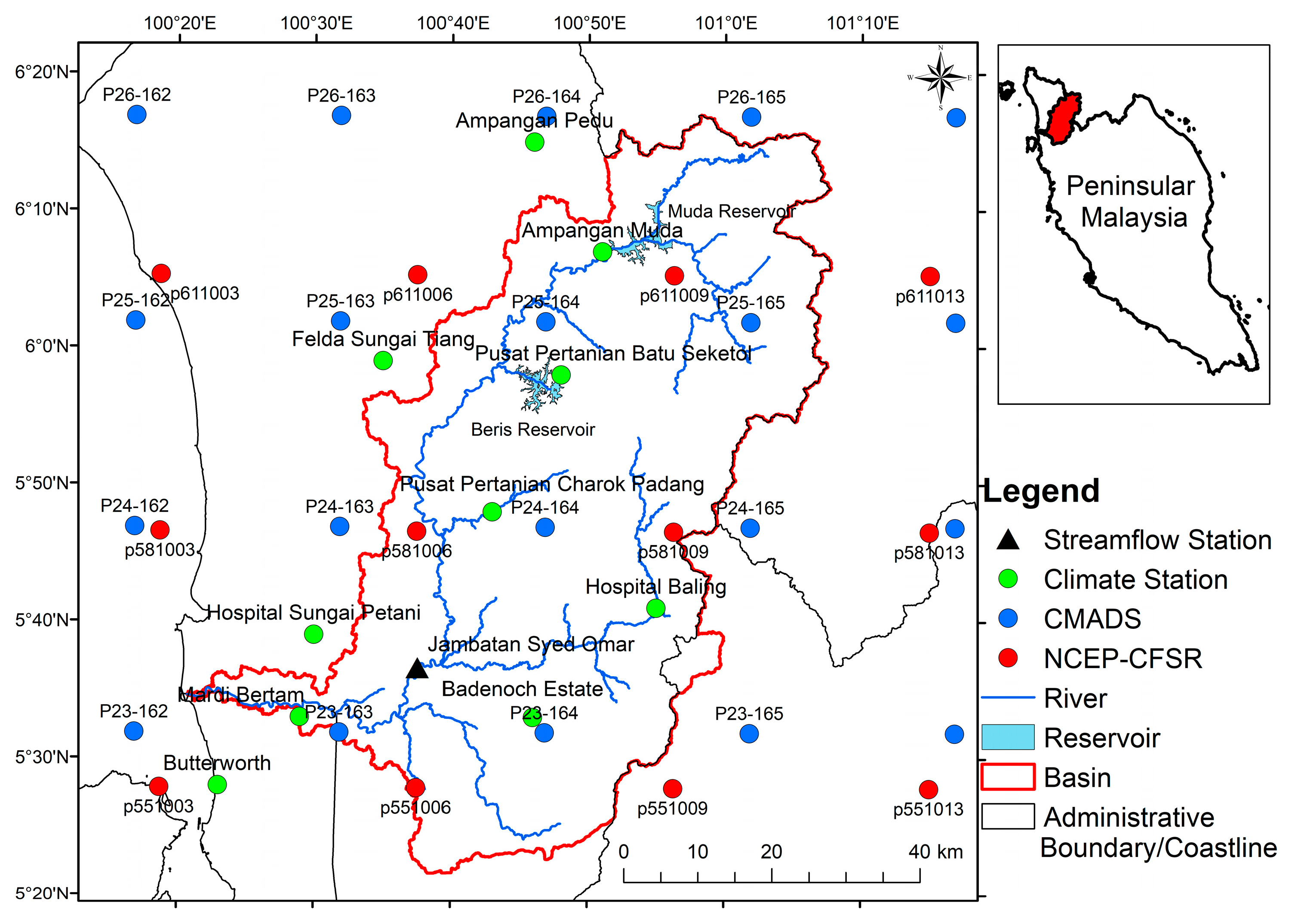
The Muda River Basin (MRB) is a typical tropical river basin that is located in the northern part of Peninsular Malaysia. It is an extremely important river basin that supplies freshwater for three northern states of Peninsular Malaysia, namely Kedah, Penang and Perlis [
25]. Freshwater in this basin is vital for agricultural purposes in Kedah and the industry sector in Penang as well as for domestic usage. Based on a review of SWAT studies in Southeast Asia [
1], only 12 SWAT-related studies have been reported in Malaysia and none of these studies were actually conducted in the Muda River Basin (MRB). A similar result was found after further searching was conducted through the SWAT literature database [
14] on 2 October 2020. Therefore, it is important to construct a hydrological model in this basin to understand the water cycle changes, so that the freshwater within this basin can be managed in a more appropriate way. Moreover, little is known on both the CMADS and SWAT applications in MRB. Hence, this study aims (1) to validate the NCEP-CFSR and CMADS daily precipitation, maximum and minimum temperatures in MRB; (2) to evaluate the performance of SWAT modelling in MRB; and (3) to assess the capability of the gauge station, NCEP-CFSR, CMADS in simulating streamflow using SWAT in MRB. The findings help to understand the performance of CMADS and SWAT in this tropical basin.
4. Discussion
In general, CMADS had an acceptable performance for monthly streamflow in MRB using SWAT. However, when compared to other similar studies as shown in
Table 7 that were mainly conducted in China, CMADS had a poorer performance in this tropical basin. The R
2 and NSE values of more than 0.8 were mainly reported in Jing River and Bo River Basins [
53], Fuhe River Basin [
22], Xiang River Basin [
32] and Lijiang River Basin [
54]. Meanwhile, Zhang et al. [
30] found CMADS performed moderately at the Shenyang station in the Hunhe River Basin, with the NSE values of 0.63 and 0.54 during the calibration and validation periods, respectively. However, the reported RB values of MRB are slightly better than in the Fuhe River Basin [
22] and Hun River Basin [
55] that show systematic bias up to 23%. A possible explanation for the poorer performance of CMADS in MRB might be that the precipitation gauges for calibrating or assimilation CMADS are mainly located within China [
56]. For regions out of China, the Climate Prediction Center Morphing Technique (CMORPH)’s integrated precipitation products were mainly used as precipitation inputs [
24,
56]. In fact, CMORPH underestimated monthly precipitation over Malaysia by ~13% [
45], which match with the underestimation of precipitation and streamflow as simulated by CMADS in this study.
Figure 4 shows the monthly observed and SWAT-simulated streamflow at the Jambatan Syed Omar discharge station from 2009 to 2014. As can be seen from the figure, the climate gauge simulated matches the observed streamflow, except for in November 2010. As reported by DID, a big flood occurred in November 2010, which inundated this region for two to five days. A total of 188 flood evacuation was operated to accommodate local people that affected by this second worst flood for the past 20 years. It can be found that NCEP-CFSR overestimated the low flow for most of the time. Meanwhile, CMADS had a better performance in low flow estimation as compared to NCEP-CFSR. A lag peak flow simulation was also found for NCEP-CFSR in several time periods, e.g., August–October 2009 and May–July 2013. Whereas, CMADS underestimated peak flows in August 2009, November 2012 and October 2013. Besides that, an overestimation of peak flows of CMADS can be found in April 2012 and May 2014. Hence, improvement of CMADS for the region out of China, particularly peak flows simulations, is an important issue for future research.
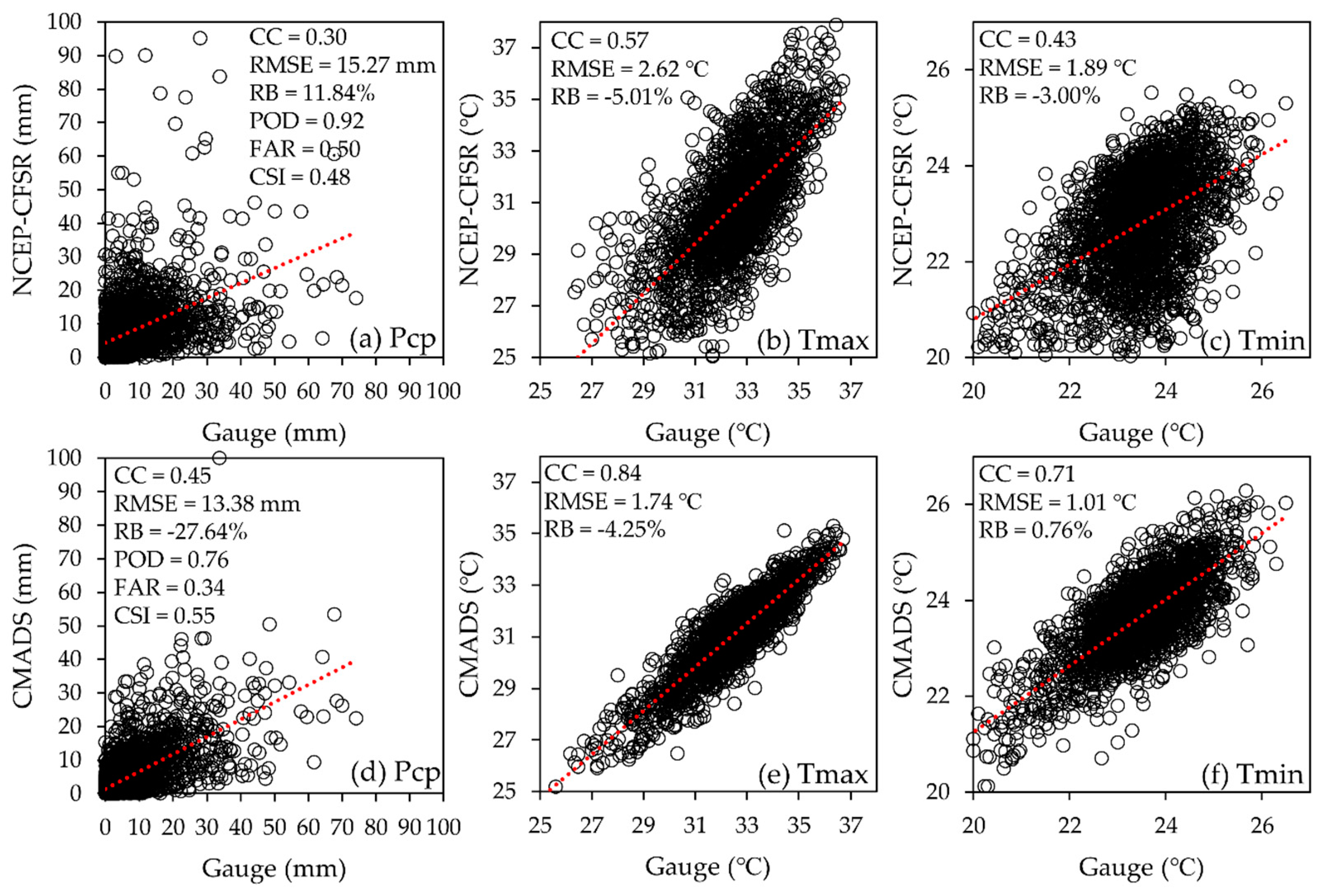
CMADS was found to be reliable in temperature data estimation for MRB, especially minimum temperature. The superior performance of CMADS temperature data compared to NCEP-CFSR, shows it is applicable to study the temperature in tropical regions such as Malaysia. For example, the CMADS temperature may be used to study the relationship between temperature and paddy yield within and nearby MRB. Besides that, temperature is important for data to calculate the evapotranspiration process within SWAT. Therefore, the reanalysis products’ temperature data, particularly maximum temperature may contain a consideration impact on the evapotranspiration calculation. The poorer performance of NCEP-CFSR in the maximum temperature estimation than CMADS might be one of the reasons that contributed to the lower performance in streamflow simulation. Future research should be undertaken to investigate the performance of the reanalysis products in more aspects including the calculation of the extreme value, trend and evapotranspiration.
As mentioned by Tan [
42], more than 20% missing values in climate data may significantly affect hydrological modelling in tropical region. Therefore, most of the gauge stations used in this study contain no or less than 3% missing values, except for the Pusat Pertanian Charok Padang (8.53%) and Pusat Pertanian Batu Seketol (10.13%) stations. Moreover, the Butterworth station is classified as a principal station that receives more attention by MMD, with no missing values for all the three climate variables. Since most of the stations contain no missing values, so the impact of the nearest station filling approach on hydrological modelling is expected to be minimal. However, a more comprehensive comparison of different imputation techniques on tropical streamflow simulation is needed in the future, including the impact of filling missing with reanalysis products.
Calibration of different parameters to better represent the local conditions is essential for proper hydrological modelling. Deterministic approaches, e.g., trial and error, were applied in the calibration process of earlier studies [
58]. However, the deterministic approaches resulted in only a single set of parameters that were insufficient to characterize the errors and uncertainties in modelling [
59]. Recently, stochastic algorithms such as SUFI-2, parallel solution (ParaSol), Markov chain Monte Carlo (MCMC), generalized likelihood uncertainty estimation (GLUE) and Particle Swarm Optimization (PSO) have been developed to capture the parameter uncertainties [
59]. In future investigations, it might be possible to test how the selection of different stochastic algorithms could impact on the model calibration and accuracy as simulated by various gridded products such as NCEP-CFSR and CMADS.
5. Conclusions
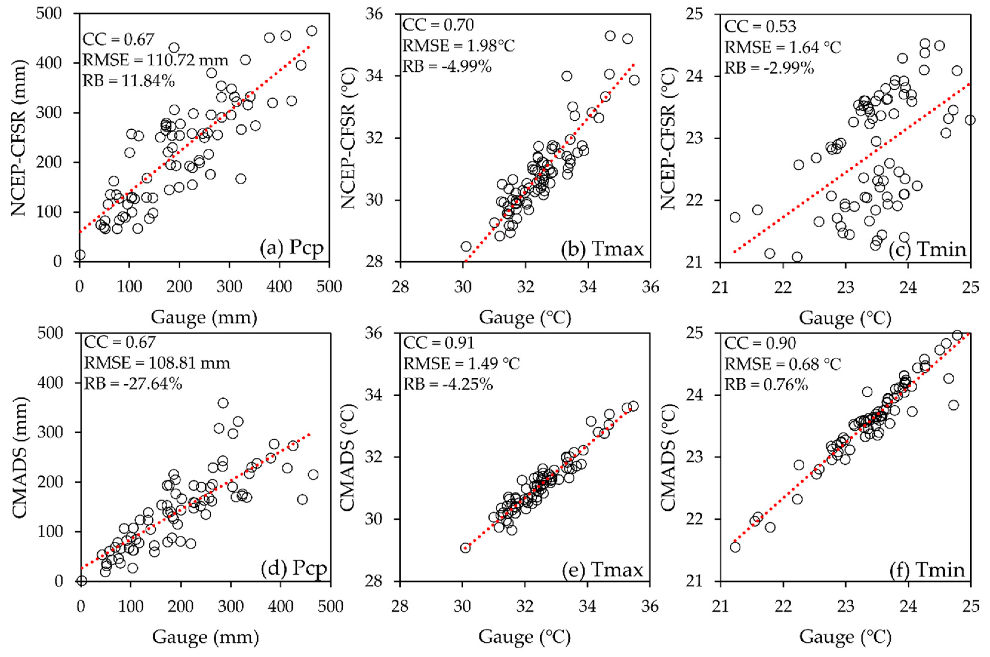
NCEP-CFSR and CMADS are potentially good to be used for hydrological modelling in ungauged or poorly gauged river basins. This study compared the reliability of NCEP-CFSR and CMADS that were freely available on the SWAT webpage in simulating streamflow in a tropical river basin that is located in the north-eastern part of Peninsular Malaysia. The evaluation was divided into the climate and hydrological aspects from 2008 to 2014. In general, CMADS performed better than NCEP-CFSR in the daily and monthly climate variables estimations. NCEP-CFSR overestimated the daily precipitation, while an underestimation was found for CMADS. The differences between observed and NCEP-CFSR or CMADS in temperature estimation is about 2 °C. Both the CMADS and NCEP-CFSR products tended to underestimate the daily maximum temperature by 4.25 and 5.01%, respectively.
The gauge station, NCEP-CFSR and CMADS products were incorporated into SWAT for the hydrological aspect assessment. Parameter sensitivity analysis shows that CN2 and ESCO are among the most sensitive parameters in the SWAT calibration of MRB, while GW_Delay and SOL_AWC are less sensitive than other parameters. The performance of gauge station in SWAT-based streamflow simulation can be considered as “very good” based on the performance rating that recommended by Moriasi [
48], showing that SWAT can be a reliable tool to study the water balance in MRB. Basically, CMADS underestimated the monthly streamflow simulation, while NCEP-CFSR showed a significant overestimation. The performance of CMADS in monthly streamflow simulation is acceptable, but more improvement is needed before applying the model for further impact assessment. In contrast, NCEP-CFSR is not suitable to be applied for SWAT modelling in MRB due to the fact that it is unable to capture the streamflow pattern effectively.


 ,
, 


