Anthropogenic Activity Effects on Canals Morphology, Case Study: Nile Delta, Egypt


 ,
, 

Abstract
1. Introduction
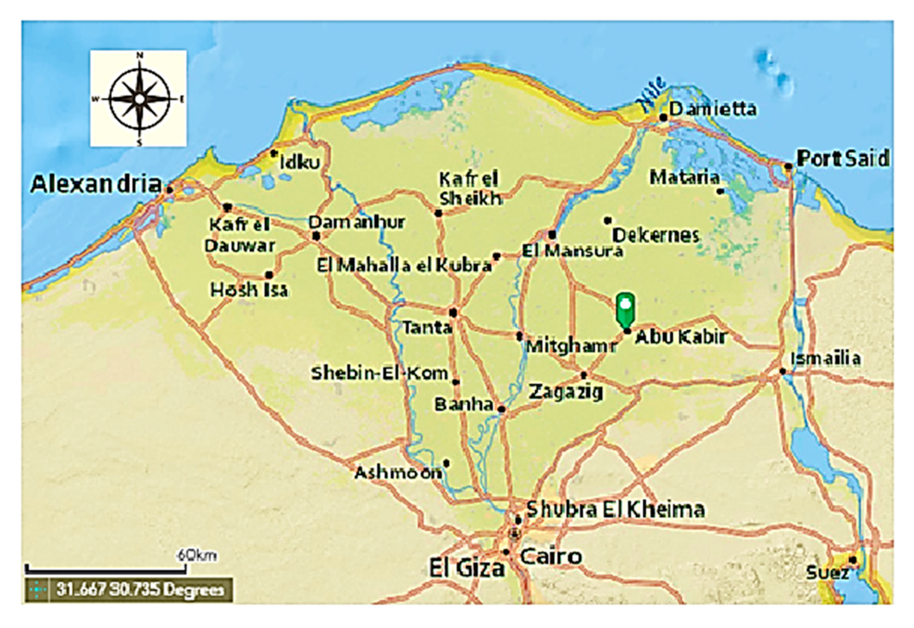
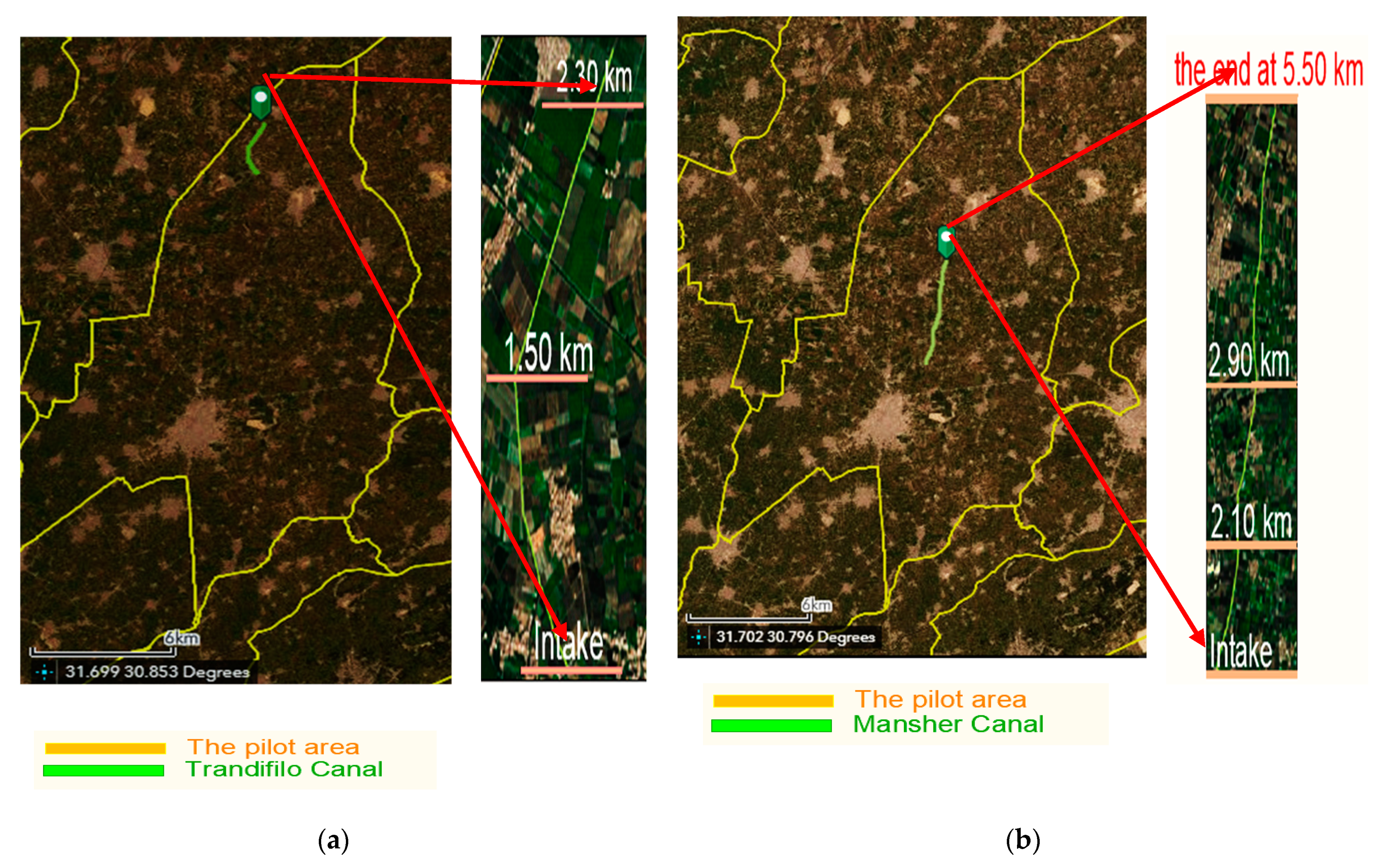
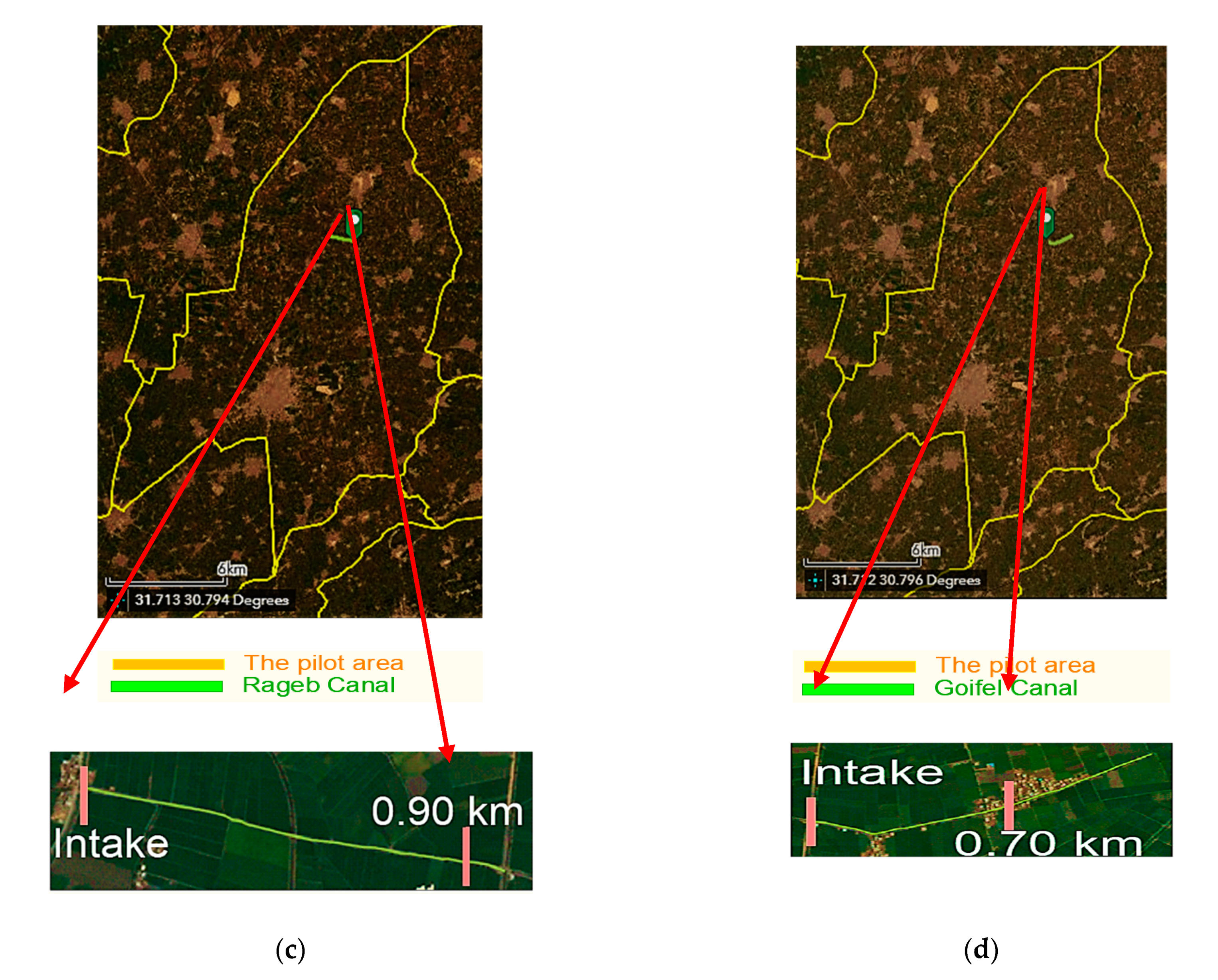
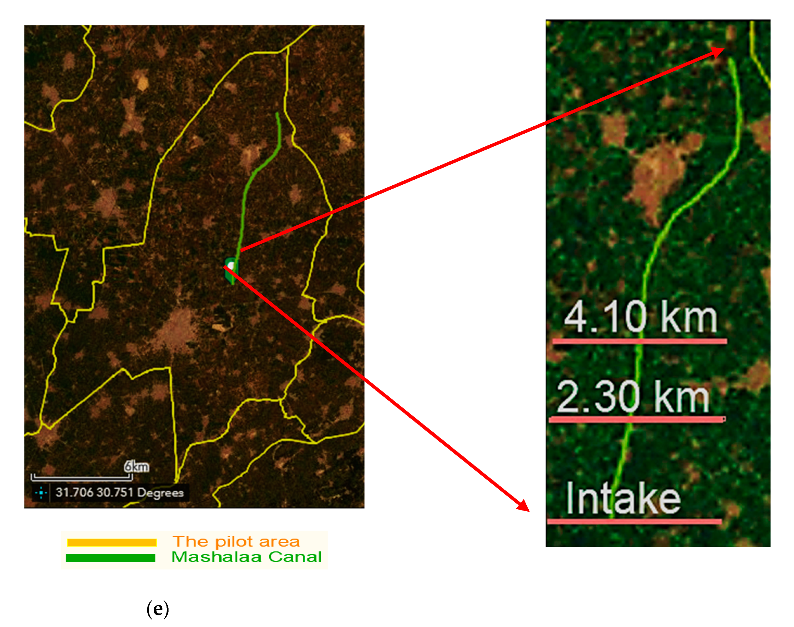
2. The Study Area
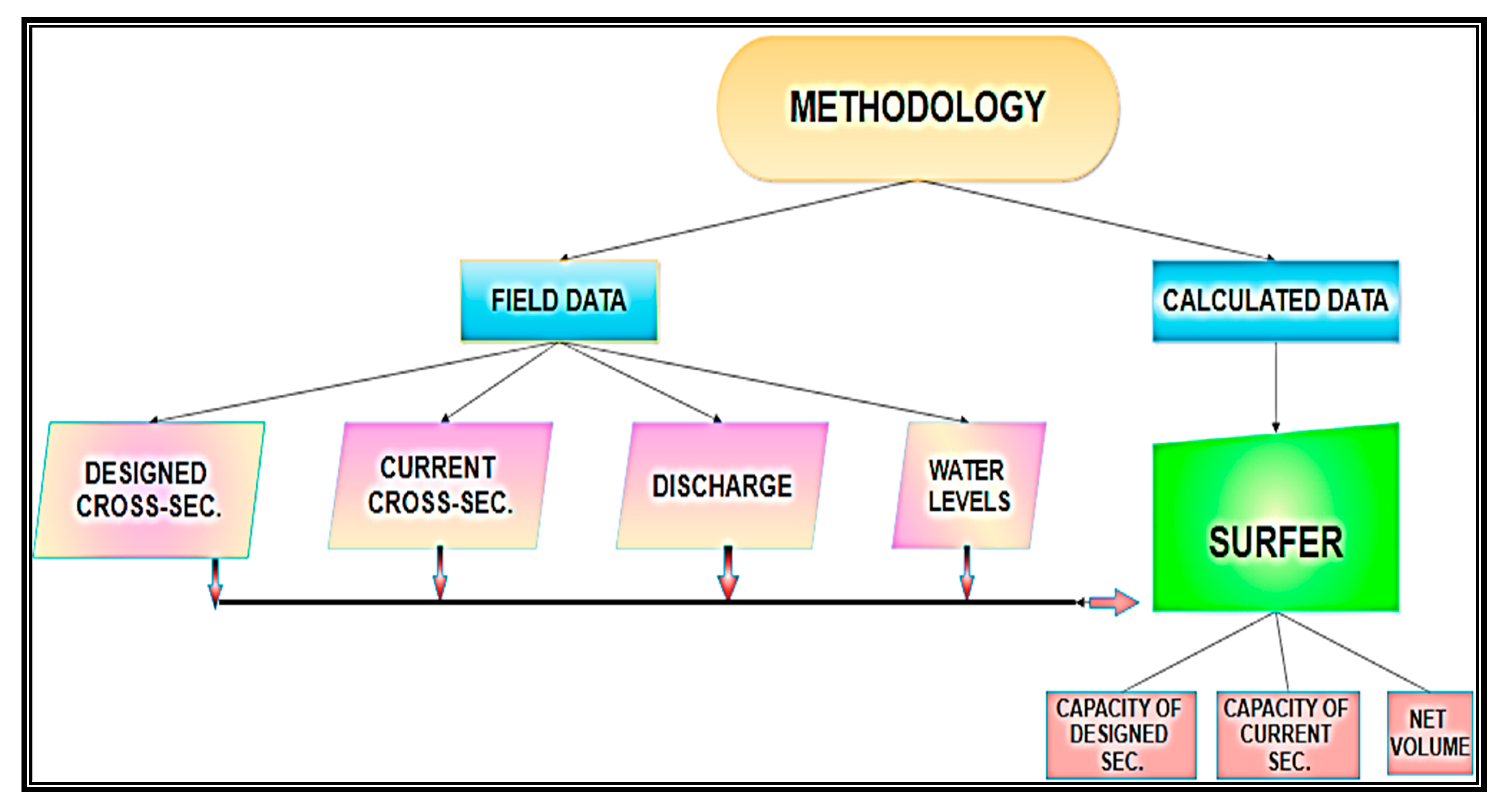
3. Methodology
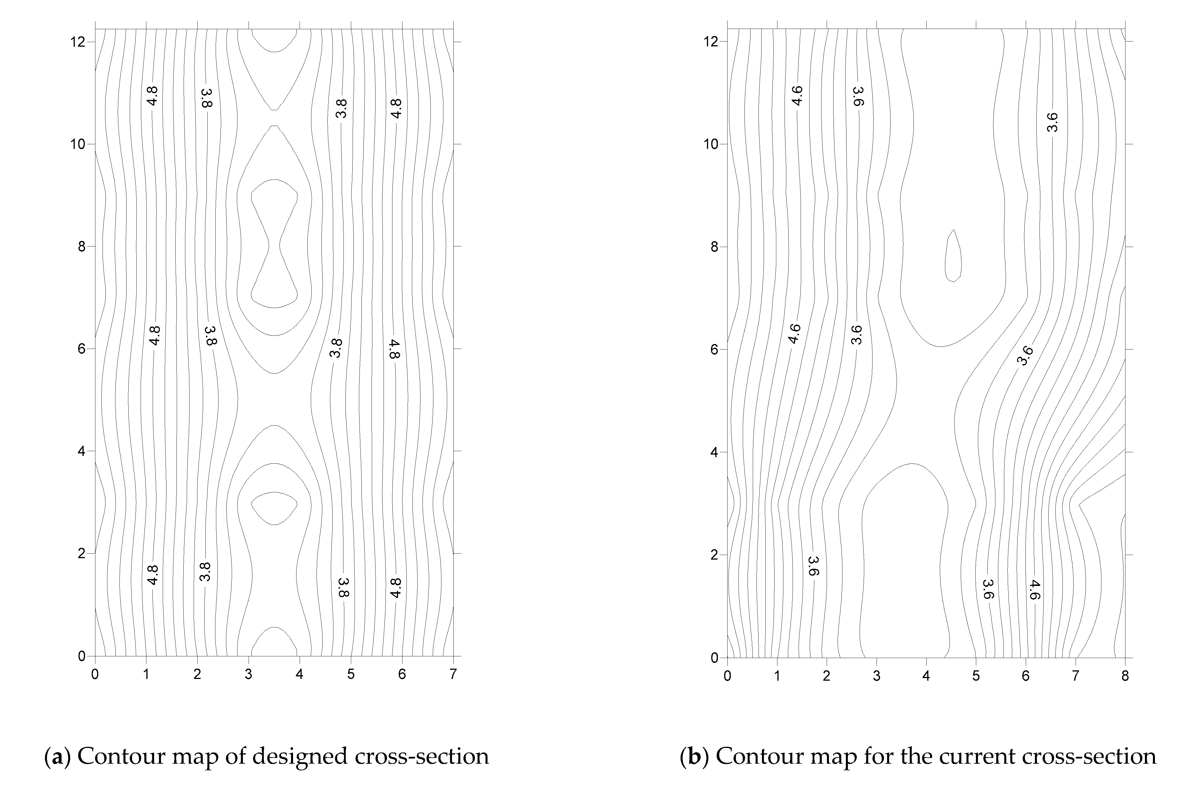
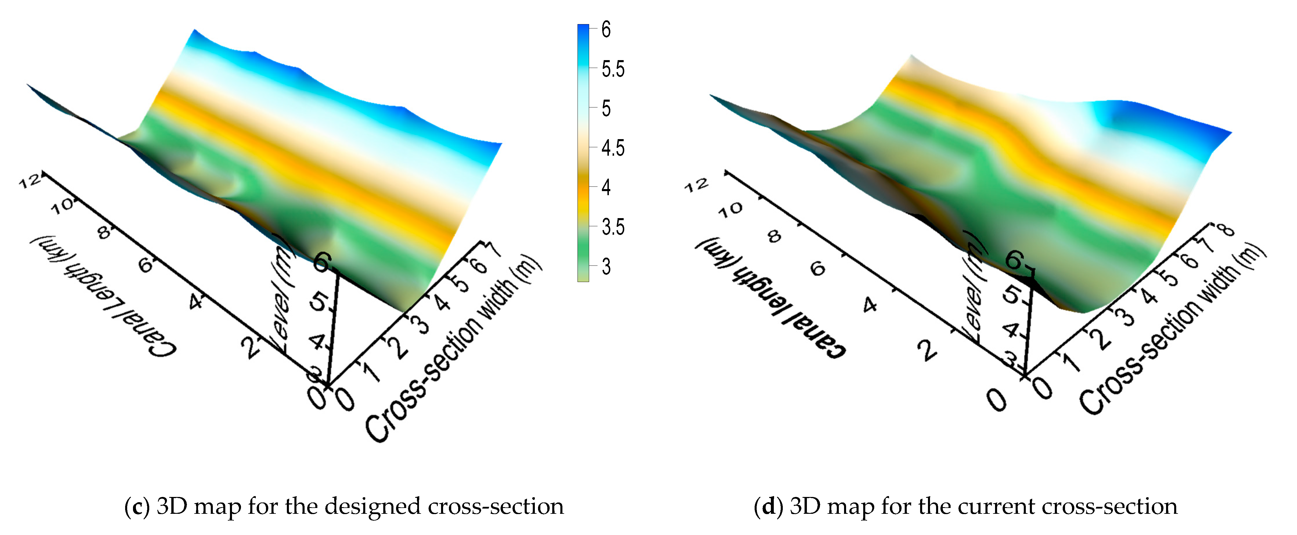
3.1. The Designed Cross-Sections of Canals
3.2. The Current Cross-Sections of Canals
4. Results
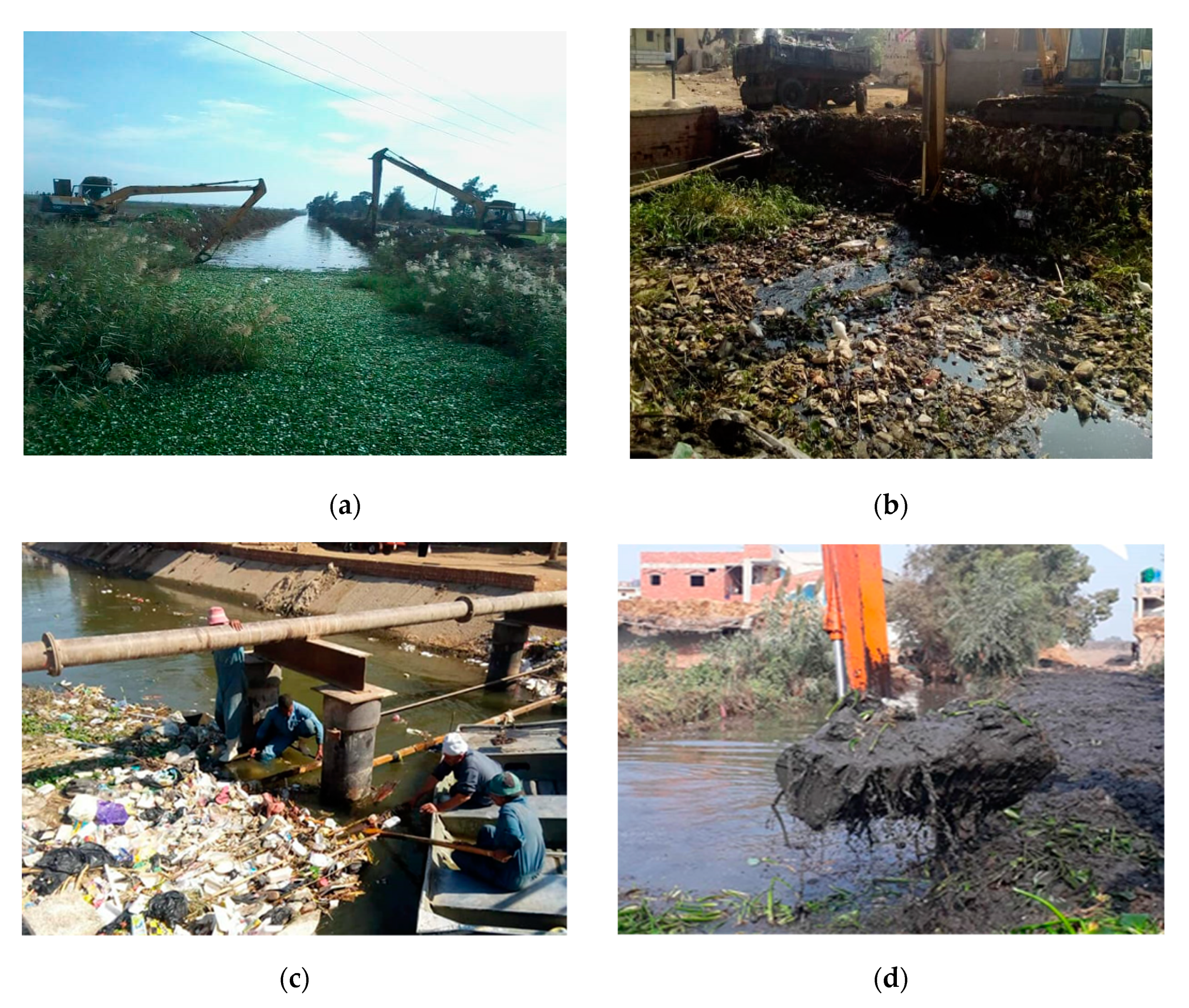
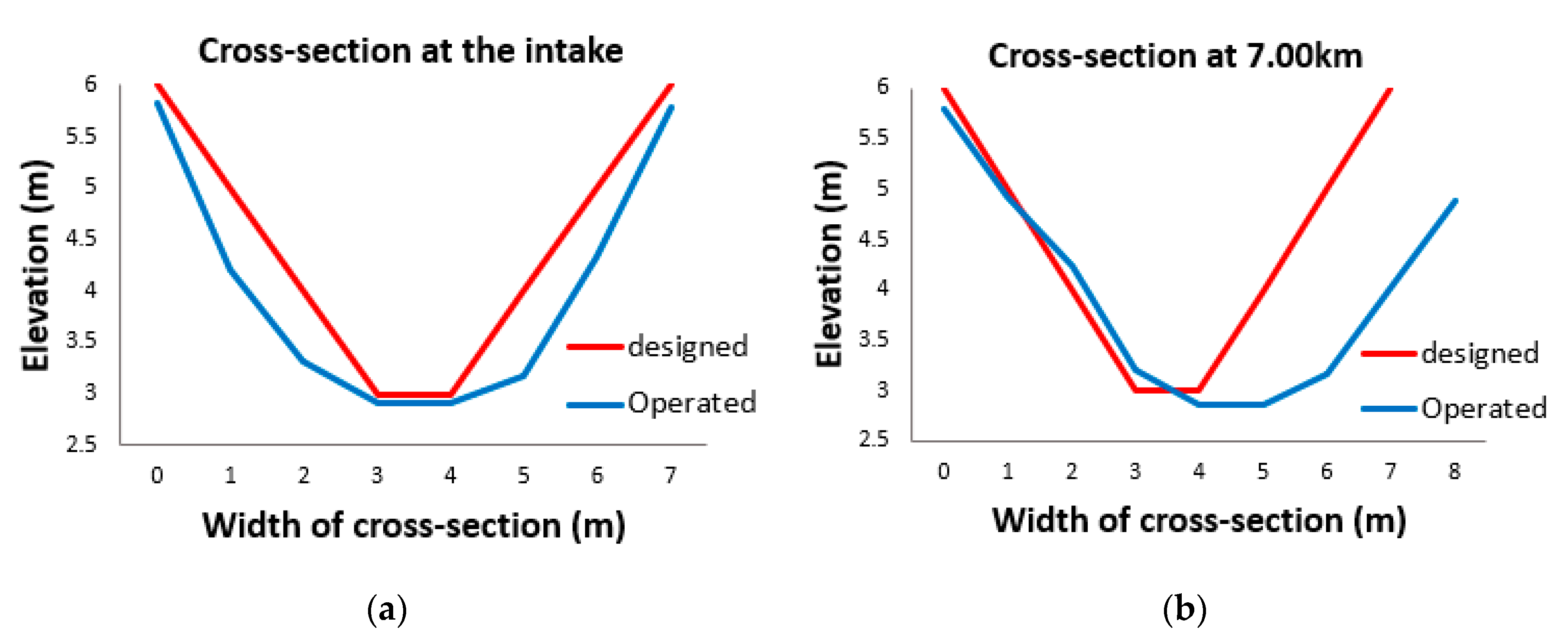
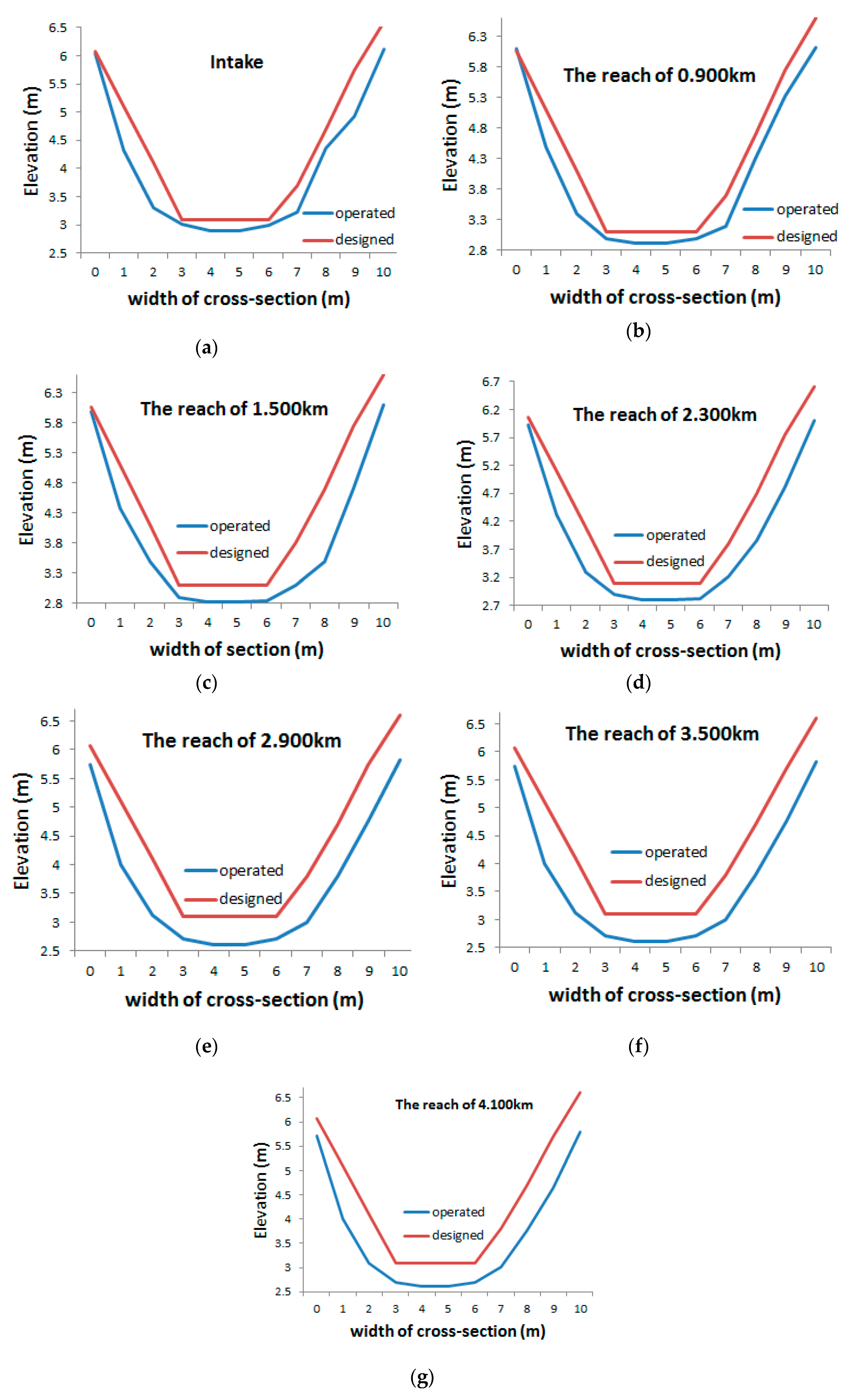
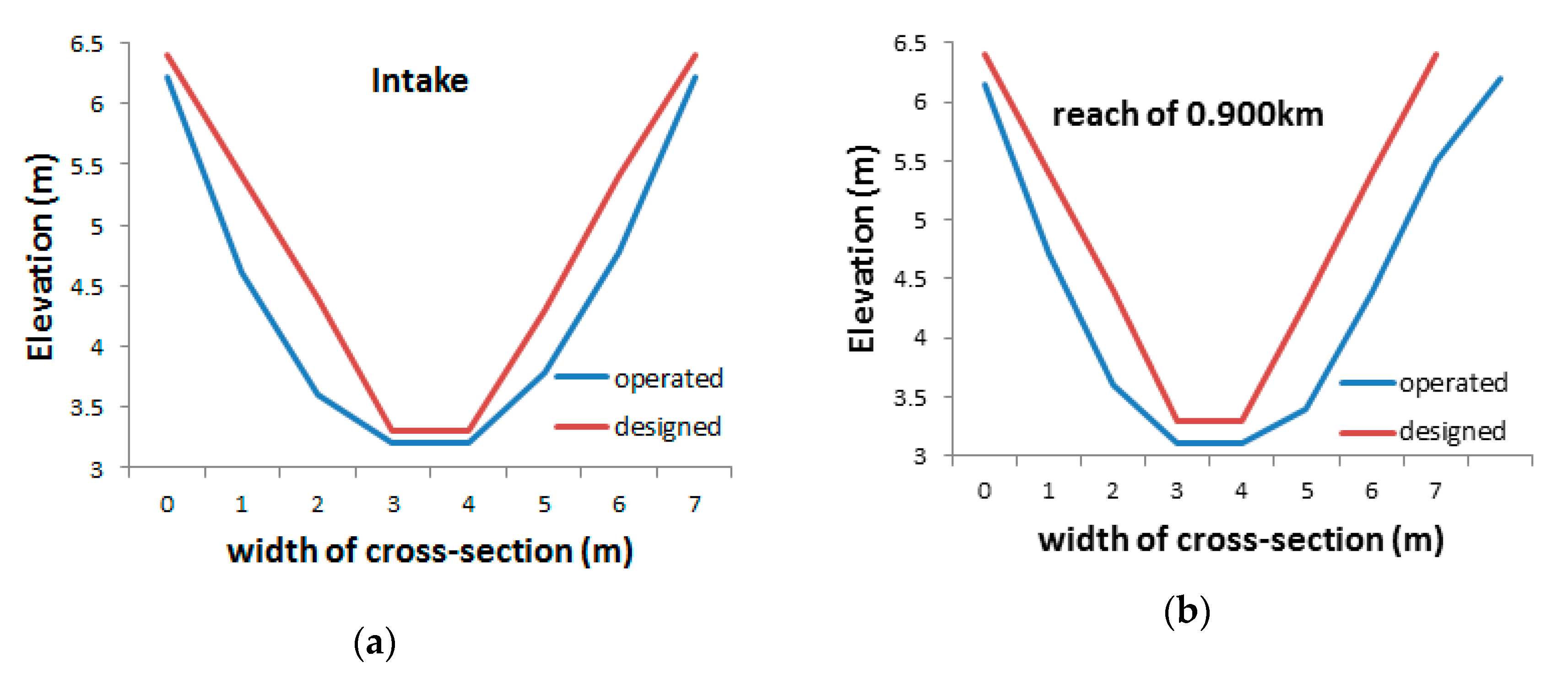
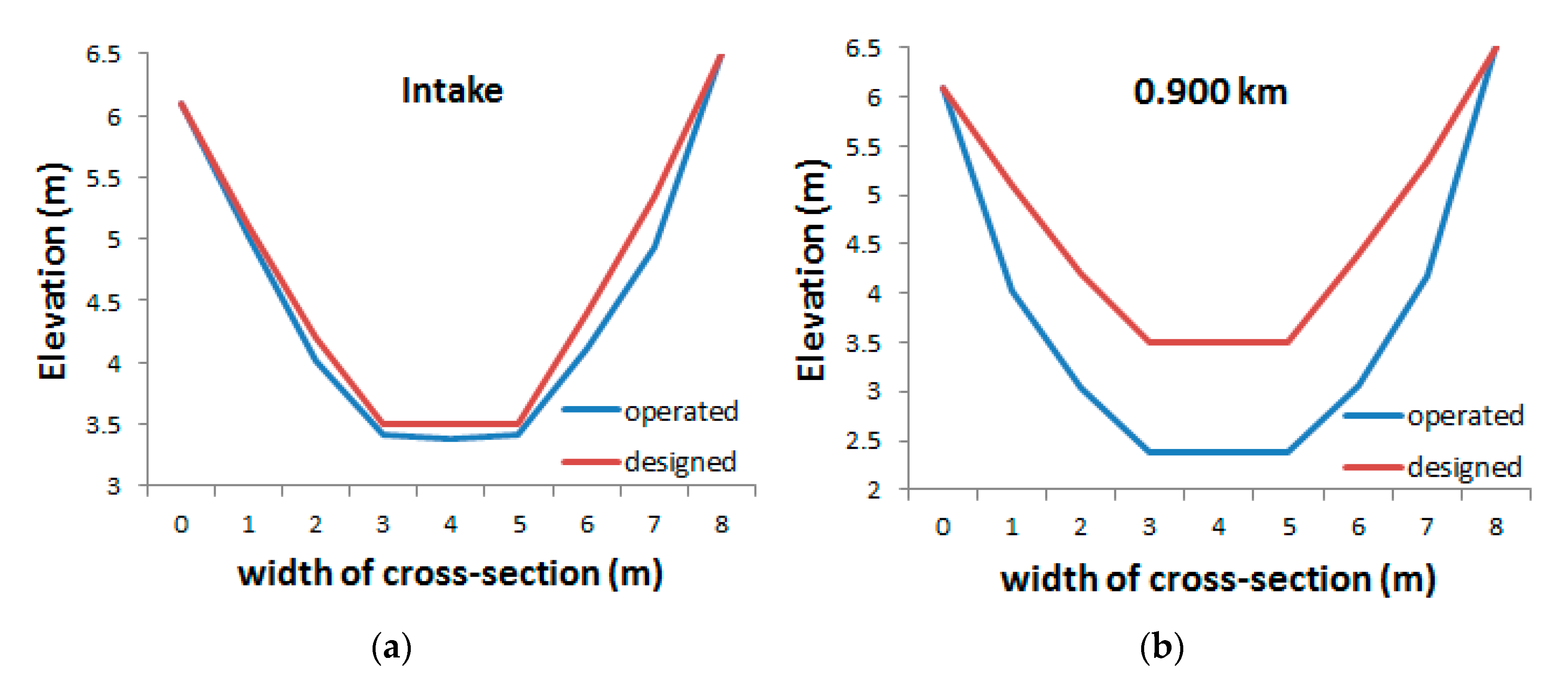
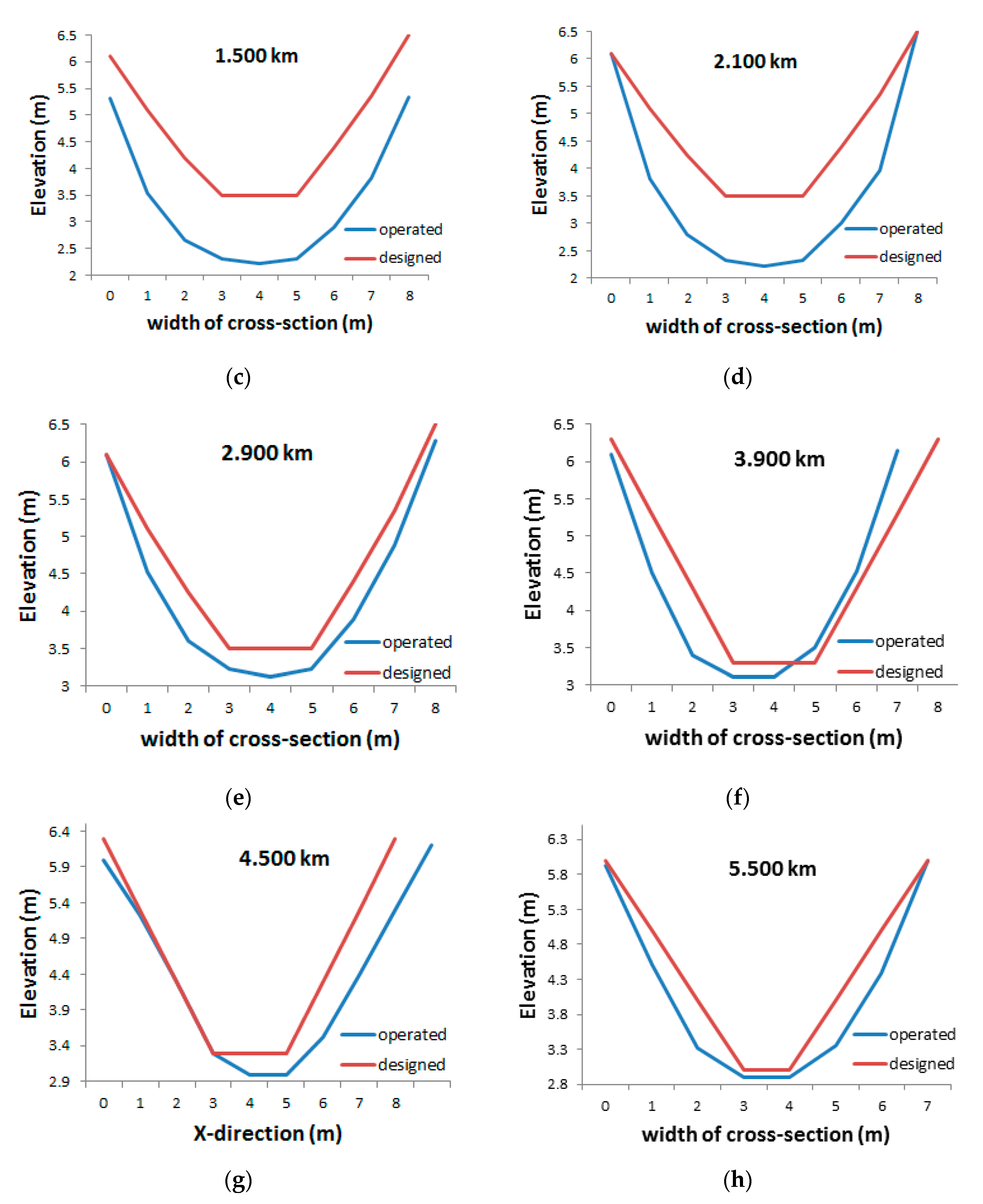
4.1. Effects of Dredging on Canal Morphology
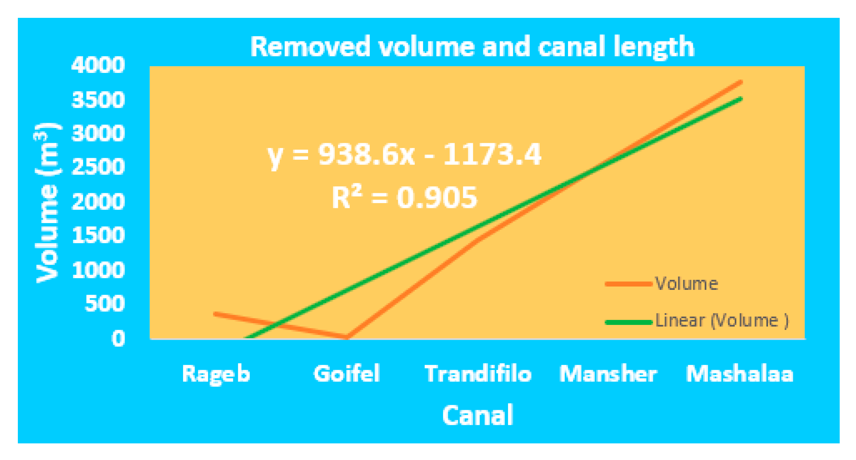
4.2. Effects of Dredging on Water Flow Rate
- Y:
- amounts of sediment removed from canal beds (m3)
- X:
- length of canal (km)
5. Discussion
6. Conclusions
Author Contributions
Funding
Acknowledgments
Conflicts of Interest
References
- Khatri, N.; Tyagi, S. Influences of natural and anthropogenic factors on surface and groundwater quality in rural and urban areas. Front. Life Sci. 2015, 8, 23–39. [Google Scholar] [CrossRef]
- Singh, R.; Kanbienaa, D.; Pandey, A. Water Quality Status of Upper Ganga Canal. In Climate Impacts on Water Resources in India; Springer: Berlin/Heidelberg, Germany, 2020; pp. 21–34. [Google Scholar]
- Egessa, R.; Nankabirwa, A.; Ocaya, H.; Pabire, W.G. Microplastic pollution in surface water of Lake Victoria. Sci. Total Environ. 2020, 741, 140201. [Google Scholar] [CrossRef]
- Khalidullin, O. Water, Electric Energy and Flood. OAGESS 2019, 2, 209–210. [Google Scholar] [CrossRef]
- Soti, P.; Goolsby, J.A.; Racelis, A. Agricultural and Environmental Weeds of South Texas and their Management. Subtrop. Agric. Environ. 2020, 71, 1–11. [Google Scholar]
- El Ella, S.; El Samman, T. Review: Egyptian Experience in Controlling Aquatic Weeds. J. Am. Sci. 2016, 12. [Google Scholar] [CrossRef]
- Bray, N.; Cohen, M. Dredging for Development; International Association of Dredging Companies (IADC): Leidschendam-Voorburg, The Netherlands; International Association of Ports and Harbours (IAPH): Tokyo, Japan, 2010. [Google Scholar]
- Shademani, S.; Zarafshan, P.; Khashehchi, M.; Kianmehr, M.; Hashemy, S. Conceptual design and analysis of a dredger robot for irrigation canals. Ind. Robot Int. J. Robot. Res. Appl. 2019, 46, 819–827. [Google Scholar] [CrossRef]
- Maheshvaran, V.; Murali, K.; Sundar, V.; Chitra, K. Study on Maintenance Dredging for Navigable Depth Assurance in the Macro-tidal Hooghly Estuary. In Proceedings of the Fourth International Conference in Ocean Engineering (ICOE2018), Glasgow, UK, 2–4 October 2018; pp. 353–367. [Google Scholar]
- Destefani, A.; Resgalla, C., Jr. Integrated evaluation of accumulated sediments in a buried channel of a subtropical estuary. Reg. Stud. Mar. Sci. 2019, 25, 100453. [Google Scholar] [CrossRef]
- Pillo, R.; Girolamo, A.; Todisco, M. Modelling the silting-up of a small reservoir fed by a temporary river: The Torrebianca reservoir study case (Puglia, SE Italy). J. Mater. Environ. Sci. 2019, 10, 225–233. [Google Scholar]
- Zhang, L.; Yuan, B.; Yin, X.; Zhao, Y. The Influence of Channel Morphological Changes on Environmental Flow Requirements in Urban Rivers. Water 2019, 11, 1800. [Google Scholar] [CrossRef]
- Yang, L.; Liu, F.; Gong, W.; Cai, H.; Yu, F.; Pan, H. Morphological response of Lingding Bay in the Pearl River Estuary to human intervention in recent decades. Ocean Coast. Manag. 2019, 176, 1–10. [Google Scholar] [CrossRef]
- Kamal, N.; Sadek, N. Evaluating and analyzing navigation efficiency for the River Nile (Case study: Ensa-Naga Hamady reach). Ain Shams Eng. J. 2018, 9, 2649–2669. [Google Scholar] [CrossRef]
- Dépret, T.; Piégay, H.; Dugué, V.; Vaudor, L.; Faure, J.-B.; Le Coz, J.; Camenen, B. Estimating and restoring bedload transport through a run-of-river reservoir. Sci. Total Environ. 2019, 654, 1146–1157. [Google Scholar] [CrossRef]
- Junakova, N.; Junak, J. Alternative reuse of bottom sediments in construction materials: Overview. In IOP Conference Series: Materials Science and Engineering; IOP Publishing: Bristol, UK, 2019; p. 012038. [Google Scholar]
- De Vincenzo, A.; Covelli, C.; Molino, A.J.; Pannone, M.; Ciccaglione, M.; Molino, B. Long-term management policies of reservoirs: Possible re-use of dredged sediments for coastal nourishment. Water 2019, 11, 15. [Google Scholar] [CrossRef]
- Sobeih, M.M.; Sadek, N.E.-S.; Helal, E.E.-D.Y.; Mohamed, N. Evaluating Efficiency of the river nile navigational path. IWTJ 2017, 7, 209–222. [Google Scholar]
- Mossa, J.; Chen, Y.-H.; Walls, S.P.; Kondolf, G.M.; Wu, C.-Y. Anthropogenic landforms and sediments from dredging and disposing sand along the Apalachicola River and its floodplain. Geomorphology 2017, 294, 119–134. [Google Scholar] [CrossRef]
- Kuriqi, A.; Koçileri, G.; Ardiçlioğlu, M. Potential of Meyer-Peter and Müller approach for estimation of bed-load sediment transport under different hydraulic regimes. Modeling Earth Syst. Environ. 2020, 6, 129–137. [Google Scholar] [CrossRef]
- Abdelhaleem, F.S.; Amin, A.M.; Basiouny, M.E.; Ibraheem, H.F. Adaption of a formula for simulating bedload transport in the Nile River, Egypt. J. Soils Sediments 2020, 20, 1742–1753. [Google Scholar] [CrossRef]
- Fathy, H.; Amin, A.M.; Abdelhaleem, F.S.; Basiouny, M.E. Experimental Approach for Bed Load Transport of Non-Uniform Sediment of the Nile River, Egypt. CERM 2020, 42, 195–213. [Google Scholar]
- Coulthard, T.J.; Van De Wiel, M.J. Modelling long term basin scale sediment connectivity, driven by spatial land use changes. Geomorphology 2017, 277, 265–281. [Google Scholar] [CrossRef]
- Pasculli, A.; Audisio, C. Cellular automata modelling of fluvial evolution: Real and parametric numerical results comparison along River Pellice (NW Italy). Environ. Modeling Assess. 2015, 20, 425–441. [Google Scholar] [CrossRef]
- Ramachandra, T.; Vinay, S.; Bharath, S.; Chandran, M.; Aithal, B.H. Insights into riverscape dynamics with the hydrological, ecological and social dimensions for water sustenance. Curr. Sci. (00113891) 2020, 118, 1379–1393. [Google Scholar]
- Kuriqi, A.; Pinheiro, A.N.; Sordo-Ward, A.; Garrote, L. Water-energy-ecosystem nexus: Balancing competing interests at a run-of-river hydropower plant coupling a hydrologic–ecohydraulic approach. Energy Convers. Manag. 2020, 223, 113267. [Google Scholar] [CrossRef]
- El Kafrawy, S.B.; Ahmed, M.H. Monitoring and Protection of Egyptian Northern Lakes Using Remote Sensing Technology. In Environmental Remote Sensing in Egypt; Springer: Berlin/Heidelberg, Germany, 2020; pp. 231–284. [Google Scholar]
- Dutta, V.; Sharma, U.; Kumar, R. Restoring Environmental Flows for Managing River Ecosystems: Global Scenario with Special Reference to India. In Environmental Concerns and Sustainable Development; Springer: Berlin/Heidelberg, Germany, 2020; pp. 163–183. [Google Scholar]
- MWRI. Available online: https://geoportal.mwri.gov.eg/portal/home/ (accessed on 14 November 2020).
- Abd-Elaziz, S.; Zeleňáková, M.; Mésároš, P.; Purcz, P.; Abd-Elhamid, H. Assessing the Potential Impacts of the Grand Ethiopian Renaissance Dam on Water Resources and Soil Salinity in the Nile Delta, Egypt. Sustainability 2019, 11, 7050. [Google Scholar]
- Bresnahan, T.; Dickenson, K. Surfer 8 Self-Paced Training Guide; Golden Software Inc.: Golden, CO, USA, 2002. [Google Scholar]
- Bashir, I.; Lone, F.; Bhat, R.A.; Mir, S.A.; Dar, Z.A.; Dar, S.A. Concerns and Threats of Contamination on Aquatic Ecosystems. In Bioremediation and Biotechnology; Springer: Berlin/Heidelberg, Germany, 2020; pp. 1–26. [Google Scholar]
- ElGamal, T.; ElGazzar, M. Applying Modern Surveying Techniques and Simulation Models for The Rehabilitation of Main Canals in Egypt: Case Study–El-Bagoriya Canal. J. Soil Sci. Agric. Eng. 2020, 11, 445–454. [Google Scholar]
- Crişu, L.; Zamfir, A.G.; Boengiu, S. Morphological changes induced by the irrigation systems and sustainable land use in baileşti plain. Present Environ. Sustain. Dev. 2020, 14, 293–309. [Google Scholar] [CrossRef]


| Canal Name | From | To (km) | Bed Width (m) | Bed Level (m) | Bed Slope (cm/km) | SS | Total Length (km) |
|---|---|---|---|---|---|---|---|
| Goifel | intake | 1.225 | 1.00 | (3.00) | 5 | 1/1 | 1.225 |
| Trandifilo | intake | 1.865 | 1.50 | (2.00) | 8 | 1/1 | 2.700 |
| 1.865 | 2.70 (end) | 1.00 | (1.85) | 8 | 1/1 | ||
| Mansher | intake | 3.110 | 2.00 | (3.60) | 11 | 1/1 | 5.500 |
| 3.110 | 5.500 (end) | 1.00 | (3.25) | 5 | 1/1 | ||
| Rageb | intake | 1.100 (end) | 1.00 | (3.30) | 10 | 1/1 | 1.100 |
| Mashalaa | intake | 4.85 | 3.50 | (3.15) | 9 | 1/1 | 10.950 |
| 4.85 | 6.500 | 2.50 | (2.65) | 10 | 1/1 | ||
| 6.500 | 9.730 | 2.00 | (2.50) | 10 | 1/1 | ||
| 9.730 | 10.950 (end) | 1.50 | (2.15) | horizontal | 1/1 |
| Canal Name | From | To (km) | Length of Section (Km) | Location of Cross-Section (km) | Bed Width (m) | Bed Level | Water Level |
|---|---|---|---|---|---|---|---|
| Goifel | intake | 0.500 | 0.500 | 0.300 | 1.00 | (2.98) | (5.80) |
| 0.500 | 1.225 | 0.575 | 0.700 | 1.00 | (2.96) | (5.80) | |
| Trandifilo | 0.500 | 1.000 | 0.500 | 0.700 | 1.50 | (1.96) | (4.57) |
| 1.000 | 1.865 | 0.865 | 1.500 | 1.50 | (1.88) | (4.51) | |
| 1.865 | 2.700 (end) | 0.835 | 2.300 | 1.00 | (1.78) | (4.49) | |
| Mansher | intake | 0.600 | 0.600 | 0.300 | 2.00 | (3.57) | (6.51) |
| 0.600 | 1.200 | 0.600 | 0.900 | 2.00 | (3.50) | (6.51) | |
| 1.200 | 1.800 | 0.600 | 1.500 | 2.00 | (3.44) | (6.33) | |
| 1.800 | 2.500 | 0.700 | 2.100 | 2.00 | (3.39) | (6.27) | |
| 2.500 | 3.110 | 610 | 2.900 | 2.00 | (3.31) | (6.25) | |
| 3.110 | 3.600 | 0.590 | 3.300 | 1.00 | (3.23) | (6.19) | |
| 3.600 | 4.300 | 0.700 | 3.900 | 1.00 | (3.17) | (6.13) | |
| 4.300 | 4.900 | 0.600 | 4.500 | 1.00 | (3.11) | (6.10) | |
| 4.900 | 5.500 (end) | 0.600 | 5.300 | 1.00 | (3.03) | (5.96) | |
| Rageb | intake | 0.600 | 0.600 | 0.300 | 1.00 | (3.26) | (6.22) |
| 0.600 | 1.100 (end) | 0.500 | 0.900 | 1.00 | (3.22) | (6.17) | |
| Mashalaa | intake | 0.600 | 0.300 | 0.300 | 3.50 | (3.11) | (6.12) |
| 0.600 | 1.200 | 0.600 | 0.900 | 3.50 | (3.07) | (6.11) | |
| 1.200 | 1.900 | 0.700 | 1.500 | 3.50 | (3.02) | (6.05) | |
| 1.900 | 2.500 | 0.600 | 2.300 | 3.50 | (2.95) | (5.96) | |
| 2.500 | 3.100 | 0.600 | 2.900 | 3.50 | (2.88) | (5.84) | |
| 3.100 | 3.800 | 0.700 | 3.500 | 3.50 | (2.83) | (5.78) | |
| 3.800 | 4.300 | 0.500 | 4.100 | 3.50 | (2.79) | (5.76) | |
| 4.300 | 4.850 | 0.550 | 4.500 | 3.50 | (2.75) | (5.75) | |
| 4.850 | 5.500 | 0.650 | 5.100 | 2.50 | (2.60) | (5.57) | |
| 5.500 | 6.000 | 0.500 | 5.700 | 2.50 | (2.55) | (5.55) | |
| 6.000 | 6.500 | 0.500 | 6.300 | 2.50 | (2.51) | (5.55) | |
| 6.500 | 7.100 | 0.600 | 6.900 | 2.00 | (2.48) | (5.52) | |
| 7.100 | 7.700 | 0.600 | 7.300 | 2.00 | (2.44) | (5.36) | |
| 7.700 | 8.400 | 0.700 | 8.100 | 2.00 | (2.36) | (5.33) | |
| 8.400 | 9.100 | 0.700 | 8.700 | 2.00 | (2.30) | (5.13) | |
| 9.100 | 9.730 | 0.630 | 9.500 | 2.00 | (2.22) | (5.03) | |
| 9.730 | 10.400 | 0.670 | 9.900 | 1.50 | (2.12) | (5.01) | |
| 10.400 | 10.950 (end) | 0.550 | 10.700 | 1.50 | (2.05) | (5.00) |
| Canal Name | Width of Cross-Section (m) | 0 | 1 | 2 | 3 | 4 | 5 | 6 | 7 | 8 | 9 | 10 | |
|---|---|---|---|---|---|---|---|---|---|---|---|---|---|
| Goiefel canal | Designated levels (m) | 6 | 5 | 4 | 3 | 3 | 4 | 5 | 6 | -- | -- | -- | |
| Operated cross-sections level (m) | intake | 5.82 | 4.2 | 3.32 | 2.92 | 2.92 | 3.18 | 4.33 | 5.79 | -- | -- | -- | |
| 3 km | 5.82 | 4.2 | 3.32 | 2.92 | 2.92 | 3.18 | 4.33 | 5.79 | -- | -- | -- | ||
| 7 km | 5.8 | 4.92 | 4.24 | 3.2 | 2.85 | 2.85 | 3.17 | 4.02 | 4.88 | -- | -- | ||
| 9 km | 5.8 | 4.92 | 4.24 | 3.2 | 2.85 | 2.85 | 3.17 | 4.02 | 4.88 | -- | -- | ||
| 12.25 km | 5.8 | 4.92 | 4.24 | 3.2 | 2.85 | 2.85 | 3.17 | 4.02 | 4.88 | -- | -- | ||
| Mashalaa canal | Designated levels (m) | 6.07 | 5.1 | 4.1 | 3.1 | 3.1 | 3.1 | 3.1 | 3.8 | 4.7 | 5.7 | 6.6 | |
| Operated cross-sections level (m) | intake | 6.04 | 4.32 | 3.3 | 3.02 | 2.9 | 2.9 | 3 | 3.22 | 4.35 | 4.92 | 6.12 | |
| 0.9 km | 6.1 | 4.5 | 3.4 | 3 | 2.92 | 2.92 | 3 | 3.2 | 4.3 | 5.32 | 6.12 | ||
| 1.5 km | 6 | 4.38 | 3.5 | 2.9 | 2.82 | 2.82 | 2.84 | 3.1 | 3.5 | 4.71 | 6.1 | ||
| 2.3 km | 5.92 | 4.33 | 3.3 | 2.9 | 2.81 | 2.81 | 2.83 | 3.22 | 3.85 | 4.82 | 6 | ||
| 2.9 km | 5.8 | 3.82 | 3.2 | 2.8 | 2.7 | 2.72 | 2.72 | 3.1 | 4 | 4.72 | 5.8 | ||
| 3.5 km | 5.74 | 4.01 | 3.12 | 2.72 | 2.6 | 2.6 | 2.72 | 3 | 3.8 | 4.77 | 5.82 | ||
| 4.1 km | 5.72 | 4 | 3.1 | 2.7 | 2.61 | 2.61 | 2.7 | 3.02 | 3.77 | 4.65 | 5.8 | ||
| Rageb canal | Designated levels (m) | 6.07 | 5.1 | 4.1 | 3.1 | 3.1 | 3.1 | 3.1 | 3.8 | -- | -- | -- | |
| Operated cross-sections level (m) | intake | 6.04 | 4.32 | 3.3 | 3.02 | 2.9 | 2.9 | 3 | 3.22 | -- | -- | -- | |
| 0.9 km | 6.1 | 4.5 | 3.4 | 3 | 2.92 | 2.92 | 3 | 3.2 | -- | -- | -- | ||
| Mansher canal | Designated levels (m) | 6.1 | 5.1 | 4.2 | 3.5 | 3.5 | 3.5 | 4.4 | 5.35 | 6.5 | -- | -- | |
| Operated cross-sections level (m) | intake | 6.1 | 5.02 | 4.02 | 3.42 | 3.38 | 3.42 | 4.12 | 4.93 | 6.51 | -- | -- | |
| 0.9 km | 6.1 | 4.03 | 3.03 | 2.39 | 2.37 | 2.39 | 3.05 | 4.17 | 6.52 | -- | -- | ||
| 1.5 km | 5.32 | 3.53 | 2.66 | 2.31 | 2.21 | 2.31 | 2.91 | 3.82 | 5.33 | -- | -- | ||
| 2.1 km | 6.1 | 3.82 | 2.8 | 2.32 | 2.22 | 2.32 | 3 | 3.97 | 6.5 | -- | -- | ||
| 2.9 km | 6.1 | 4.52 | 3.6 | 3.22 | 3.12 | 3.22 | 3.9 | 4.88 | 6.28 | -- | -- | ||
| 3.9 km | 6.1 | 4.5 | 3.4 | 3.1 | 3.1 | 3.5 | 4.52 | 6.15 | 6.1 | -- | -- | ||
| 4.5 km | 6 | 5.22 | 4.3 | 3.3 | 3 | 3 | 3.52 | 4.39 | 5.3 | 6.2 | -- | ||
| 5.5 km | 5.92 | 4.51 | 3.32 | 2.9 | 2.9 | 3.35 | 4.38 | 6 | -- | -- | -- | ||
| Trandifilo cacal | Designated levels (m) | 5 | 4 | 3 | 2 | 2 | 2.7 | 3.5 | 4.5 | 5.5 | -- | -- | |
| Intake | 4.62 | 3.4 | 2.35 | 1.9 | 1.83 | 2.11 | 2.9 | 3.88 | 4.52 | -- | -- | ||
| 1.5 km | 4.53 | 3.32 | 2.39 | 1.82 | 1.72 | 2.01 | 2.7 | 3.69 | 4.48 | -- | -- | ||
| 2.3 km | 4.48 | 3.42 | 2.6 | 1.82 | 1.7 | 1.7 | 1.88 | 2.5 | 3.39 | -- | -- | ||
| Canal | Goifel | Mansher | Mashalaa | Rageb | Trandifilo |
|---|---|---|---|---|---|
| Designated volume (m3) | 1277 | 7857 | 6909 | 1202 | 2455 |
| Current volume (m3) | 1303 | 10,467 | 10,677 | 1569 | 3896 |
| increase in water volume % | 2% | 33% | 55% | 31% | 59% |
| Q actual (m3/s) | 2.12 | 2.64 | 2.88 | 2.09 | 1.97 |
| Excess vol./day (m3) | 183,168 | 228,096 | 248,832 | 180,576 | 170,208 |
| Excess vol./year (mill. m3) | 66.9 | 83.26 | 90.82 | 65.91 | 62.13 |
| Case Study | Pilot Area | Egypt June 2020 | Egypt December 2020 | Egypt 2022 | |
|---|---|---|---|---|---|
| Length of rehabilitated canals (km) | 21.475 | 223.855 | 1500 | 3000 | 7000 |
| Saved water (million m3) | 0.019 | 0.209 | 1.407 | 2.815 | 6.569 |
Publisher’s Note: MDPI stays neutral with regard to jurisdictional claims in published maps and institutional affiliations. |
© 2020 by the authors. Licensee MDPI, Basel, Switzerland. This article is an open access article distributed under the terms and conditions of the Creative Commons Attribution (CC BY) license (http://creativecommons.org/licenses/by/4.0/).
Share and Cite
Abd-Elaziz, S.; Zeleňáková, M.; Mésároš, P.; Purcz, P.; Abd-Elhamid, H.F. Anthropogenic Activity Effects on Canals Morphology, Case Study: Nile Delta, Egypt. Water 2020, 12, 3184. https://doi.org/10.3390/w12113184
Abd-Elaziz S, Zeleňáková M, Mésároš P, Purcz P, Abd-Elhamid HF. Anthropogenic Activity Effects on Canals Morphology, Case Study: Nile Delta, Egypt. Water. 2020; 12(11):3184. https://doi.org/10.3390/w12113184
Chicago/Turabian StyleAbd-Elaziz, Sherien, Martina Zeleňáková, Peter Mésároš, Pavol Purcz, and Hany F. Abd-Elhamid. 2020. "Anthropogenic Activity Effects on Canals Morphology, Case Study: Nile Delta, Egypt" Water 12, no. 11: 3184. https://doi.org/10.3390/w12113184
APA StyleAbd-Elaziz, S., Zeleňáková, M., Mésároš, P., Purcz, P., & Abd-Elhamid, H. F. (2020). Anthropogenic Activity Effects on Canals Morphology, Case Study: Nile Delta, Egypt. Water, 12(11), 3184. https://doi.org/10.3390/w12113184