1. Introduction
Climate change has been an increasingly popular topic in both scientific and public discourse in recent years. One of the most obvious manifestations of climate change is its influence on water balance and hydrological processes across the globe. For example, in the U.S., Chattopadhyay et al. [
1,
2] noted the high sensibility of hydrological response to climate variations (i.e., changes in precipitation and temperature) in the Kentucky River basin and Haw River watershed. Kumar et al. [
3] reported relationships of over-proportional runoff-rainfall and under-proportional percolation-rainfall, indicating the future enhancement of floods in the Kharun catchment in India. In tropical catchments, such as Samin on Java, Indonesia, Marhaento et al. [
4] found that land use change and climate change could individually cause changes in water balance components, but the changes are more pronounced in the case of combined drivers. Various studies claimed that the impact of climate change on drainage/river basins might contribute to runoff reduction in most dry tropical regions [
5] while increasing runoff volume in the high latitudes and humid tropics [
6,
7]. Overall, climate change is considered to be the dominant factor influencing runoff over a long-term span, whereas the variations in hydrological processes in a short-term span are mainly caused by human interventions [
8,
9]. These impacts lead to difficulty and complication of solutions adapting to climate change and water-related disasters, especially flooding, as it has been known as the most common and damaging hazards [
10,
11].
The runoff coefficient, which is influenced by not only climatic effects but also human impacts, is a fundamental indicator used in flood control, water balance, and water resources management [
12,
13]. This factor is contributed by two components: the surface runoff coefficient and the groundwater runoff coefficient. The surface runoff coefficient, which directly represents the ratio between the amount of surface runoff and the amount of precipitation received in a rainfall event, is a crucial parameter for flood peak discharge estimates in ungauged drainage basins [
14]. The remaining component, the groundwater runoff coefficient, which can be considered to be the main contribution of the runoff coefficient, is more related to many long-term processes influenced by hydrogeological conditions [
15]. This component is normally applied in determining the joint effect of the regional environmental and hydro-climatologic factors [
16]. However, due to the importance of the runoff coefficient in construction plans to prevent flooding during periods of heavy rain, this coefficient is frequently considered an event-based index, focusing only on the surface runoff coefficient in most previous studies [
17,
18].
In recent years, a few studies have initially analyzed the change in the runoff coefficient along with studying the variability in precipitation and streamflow in some typical areas in long-term periods, but these analyses are primarily based on historical in-situ records [
19,
20,
21]. In addition, the runoff coefficient normally reflects the characteristics of local topography, soil, land cover/land use, and aquifers [
22]. In the case that such factors do not change, the runoff coefficient is expected to be more stable in time and space than other climatic or hydrological factors [
14,
18]. Based on such studies, a number of constructions regarding flood prevention or water resources management have been under development for long-term use. However, in the context of climate change, these constructions potentially become inefficient or costly solutions due to a non-thorough understanding of the runoff coefficient as a fundamental design parameter.
Meanwhile, higher temperatures are reported to increase rates of hydrologic system losses to evapotranspiration, resulting in higher annual precipitation and more frequent extreme rainfall events [
23,
24]. Along with the increase in the amount, the spatial and temporal distribution of precipitation is also expected to be more complicated [
25]. In South Korea, the substantial difference in precipitation caused by the impact of the East Asian monsoon separates the climate into two distinct seasons: dry season (October to March) and wet season (June to September) [
26,
27]. This seasonal difference leads to complex variation in the runoff coefficient and its components between these two seasons, not only in the inner-annual but also in the intra-annual climate.
To overcome these challenges, numerous studies have focused on variations in water balance components under various climate change scenarios in South Korea. Jung et al. [
28] found a difference in the trend of future precipitation during the dry and wet seasons, in which precipitation in the wet season increases with a higher rate than that in the dry season. Bae et al. [
29,
30] applied the Precipitation Runoff Modeling System (PRMS) model to analyze spatial and temporal variation in runoff and indicated that the trend of runoff is less pronounced than that of precipitation. Multiple recent studies have examined hydrological responses to the individual and combined influences of climate change and human interference. Kim et al. [
31] assessed the impacts of climate change and weirs on future regional-scale runoff in the Geum River Basin and reported that climate change would lead to an increase in the future runoff ratio, while weirs contribute to an increase in minimum discharge and a decrease in maximum discharge. Lee et al. [
32] indicated a regional difference in the dominant influence between climate change and human activities in the Soyang Dam upper basin and the Seom River basin.
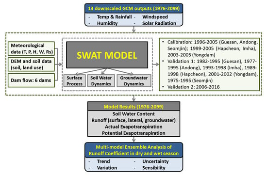
In general, the runoff coefficient and its components have only been analyzed along with studying the behavior of precipitation and runoff in such studies using historical data. Recently, the use of the general circulation models (GCMs) output data combined with hydrological models has become one of the most effective methods to project the variation of climatic and hydrological variables. Thus, the objective of this study is to apply this method to investigate the long-term variation in the runoff coefficient and its components in the dry and wet seasons and provide insights into the change in this coefficient in the future, which is vital for flood prevention design and construction as well as long-term water resources management to adapt to climate change in South Korea.
2. Study Area
South Korea is located at the eastern end of the Asian continent and occupies the lower half of the Korean peninsula (99,025 km
2). Steep mountain ranges are distributed along the eastern coastline, while wide alluvial plains spread out to the west and south. Thus, the rivers that flow to the eastern coast are short and steep, whereas long rivers with gentle slopes discharge to the southern or western coast. South Korea is divided into five major basins: Han, Nakdong, Geum, Seomjin, and the Yeongsan River basin (
Figure 1). The Han River basin is the largest basin, and the Nakdong River is recognized as the longest river, with a total length of approximately 525 km. The area of South Korea is mostly covered by forest (66%) and paddy field (18%) (
Table 1). More than 90% of the agricultural land is located on slopes (>2°), and 40% of that land is located on slopes of 7°–15°.
The aquifer geology of South Korea mainly consists of crystalline rocks (granite and gneiss) and some sedimentary rocks (limestone and sandstone), which are largely formed in the Precambrian and Paleozoic eras [
33]. The Precambrian metamorphic sedimentary rocks are predominantly distributed in the northern and central parts of South Korea. The Paleozoic layer is distributed in the eastern part of the Geum River basin. Relatively, large Mesozoic strata occur in the western part, in the Nakdong River basin. Quaternary alluvial deposition is narrowly distributed around large rivers or major streams.
The climate system of South Korea is driven by the effects of continental air masses during the winter and warm, humid air masses from the ocean in the summer. The annual mean temperature is 14 °C along the southern coast and then drops to 11 °C and 8 °C in the mid and northern zones, respectively. The annual rainfall distribution is determined by the dry wind from the Siberian High in the winter and the East Asia monsoon in the summer. The annual rainfall is 1274 mm, with approximately 66% received in the wet season from June to September, 16% in the transition period from April to May, and the remaining 18% in the six months of the dry season from October to March [
34].
5. Discussion
Although the SWAT model shows its capacity to simulate surface runoff, groundwater flow, and total runoff, as well as other water balance components (e.g., soil moisture volume and evapotranspiration), it is limited in simulating low flow as figured out in
Section 4.1. During the flood (or wet) season, when the total streamflow is relatively high, this limitation insignificantly affects simulated streamflow; nevertheless, in the dry season, it probably increases the uncertainty of simulations. This uncertainty is related to the method used for computation of the baseflow, which is normally associated with the return flow from groundwater [
68,
69], and to the approach used for simulation of snow melt, which is directly related to surface runoff estimation in the dry season. The poor performance impacts the estimations of groundwater runoff and dry season surface runoff, contributing to the uncertainty of the runoff coefficient in the dry season, as the amount of rainfall in this season is projected as nonsignificant. Multiple recent studies have tried to improve baseflow simulation by modifying the SWAT model regarding the aquifer structure and the interaction between aquifers [
70], applying a nonlinear aquifer storage–discharge relation approach instead of the traditional approach available in the original model [
71] or using a multicell aquifer to represent the regional aquifer [
72]. This problem needs to be cautiously considered in further study by applying a separate baseflow separation program or improving the approach used to simulate baseflow inside the SWAT model.
The other uncertainty in the SWAT model simulations may come from the concept of HRUs, where the comprehensive parameters were calibrated and validated for each subbasin using the observed streamflow, but the parameters for the HRUs in the same subbasin are supposed to be uniform. One additional uncertainty was identified in the study of Wang et al. [
73]. The study states that the impact of short-duration rainfall on streamflow could not be differentiated using the SWAT model, leading to the high uncertainty of the runoff coefficient, but the uncertainty could be reduced by averaging for long-term periods.
The SDQDM downscaling method used in this study demonstrates its capacity to preserve the long-term trend of climatic variables, such as precipitation and minimum and maximum temperature. However, CanESM2 and IPSL-CM5A-MR models show good skills when compared for the entire Korean peninsula but propose relatively poor results on the regional scale. This may be related to the spatial resolution of the GCMs; these models could not represent the regional characteristics at each point in detail, resulting in a decrease in the regional difference of simulation results. Additionally, as found in the study of Eum and Canon [
43], the SDQDM method tends to slightly overestimate the number of consecutive dry days (daily precipitation < 1 mm), and underestimate the number of consecutive wet days (daily precipitation ≥ 1 mm), leading to slight underestimates of the increase in total precipitation and runoff.
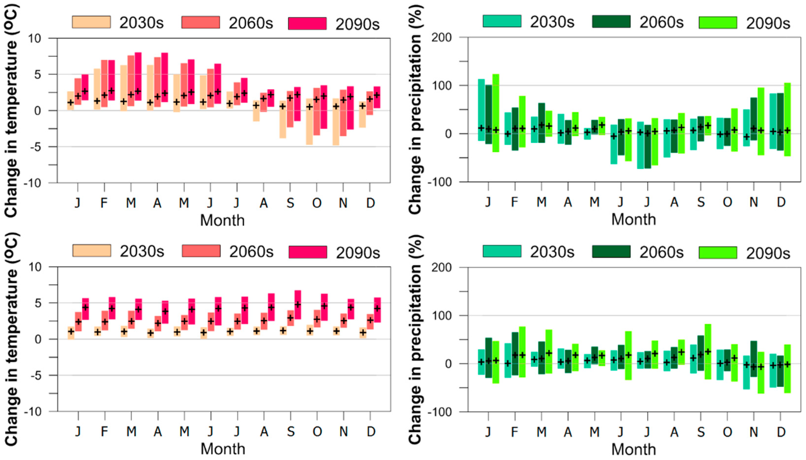
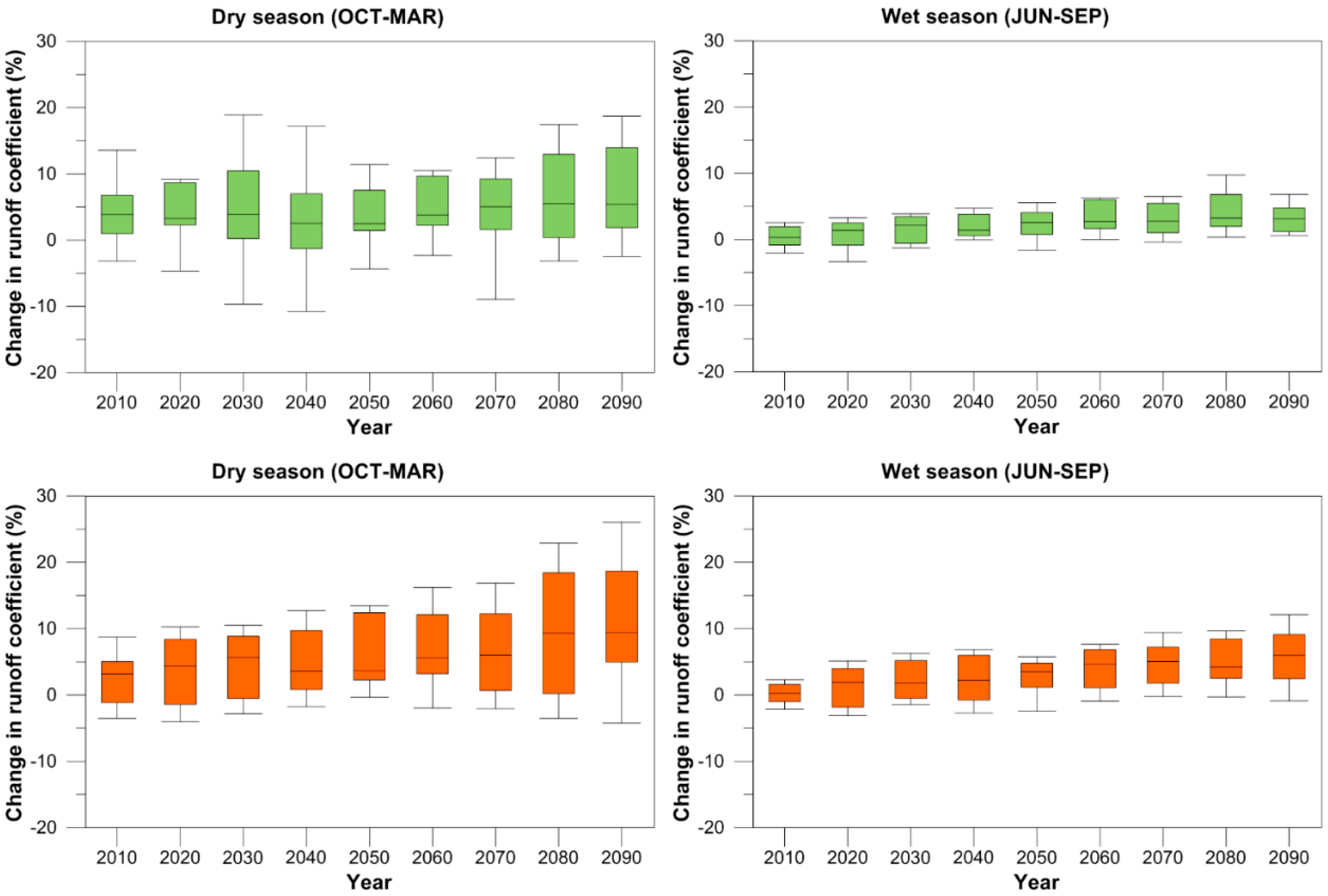
The trend of temperature and precipitation in South Korea is projected to be positive during the 21st century. While the increase in temperature in the study area is considered an obvious consequence of global warming, the increase in precipitation is more related to regional effects, such as the East Asian monsoon [
26,
27] or Southern Oscillation [
74,
75]. Precipitation in the wet season shows a higher increasing trend compared to precipitation in the dry season in all basins, which is strongly related to the temporal change in the Changma front, as found in a number of previous studies [
76,
77]. Based on the results of the present study, the increase in precipitation due to climate change leads to a significant increase in streamflow and runoff coefficient. In particular, the increase in the runoff coefficient in the dry season was mainly due to the increase in groundwater flow, whereas the increase in the runoff coefficient in the wet season mostly came from the decrease in the evaporative index.
The increase in streamflow in rain-dominant basins results in an increase in flood frequency and intensity [
28]. To develop construction plans to prevent flooding under climate change conditions in the future, the runoff coefficient is required as a critical parameter for designing. However, currently, this coefficient is only derived by traditional methods without considering the impact of climate change. Hence, the present study provides an insightful analysis of the variation in the runoff coefficient in the future, which needs to be deliberated when developing construction to adapt to climate change. Furthermore, the increase in the runoff coefficient probably predicts the decrease in the water storage capacity of the soil, leading to an increase in hydrologic drought conditions in South Korea.
On the one hand, various studies reported an increase in the surface runoff due to the increase in urban areas [
78,
79], resulting in the rising frequency of flood occurrences. On the other hand, it has been stated that the groundwater recharge might be reduced with the urbanization expansion because of the increase in impervious cover [
80]. As a consequence, the negative correlation between the total runoff coefficient and the percentage of urban land in both the wet and dry seasons in the long-term span figured out in the present study potentially lead to the high risk of the water scarcity and flooding, especially the flash and urban floods in the future.
One of the limitations of the present study is that the temporal changes in the future of land cover/land use and other factors were not considered. However, the variation in the total runoff coefficient is potentially associated with the spatial change in land cover/land use in South Korea. Due to the combined impact of a number of soil and vegetation cover features, as well as the change in climate factors, it is difficult to identify the direct-close-clear relationship between land cover/land use and the variation in the runoff coefficient. This initial analysis suggests a correlation between spatial changes in land cover/land use and variations in the runoff coefficient in the future. This relationship would be clarified using scenarios of land use/land cover and other variable changes in further study.
6. Conclusions
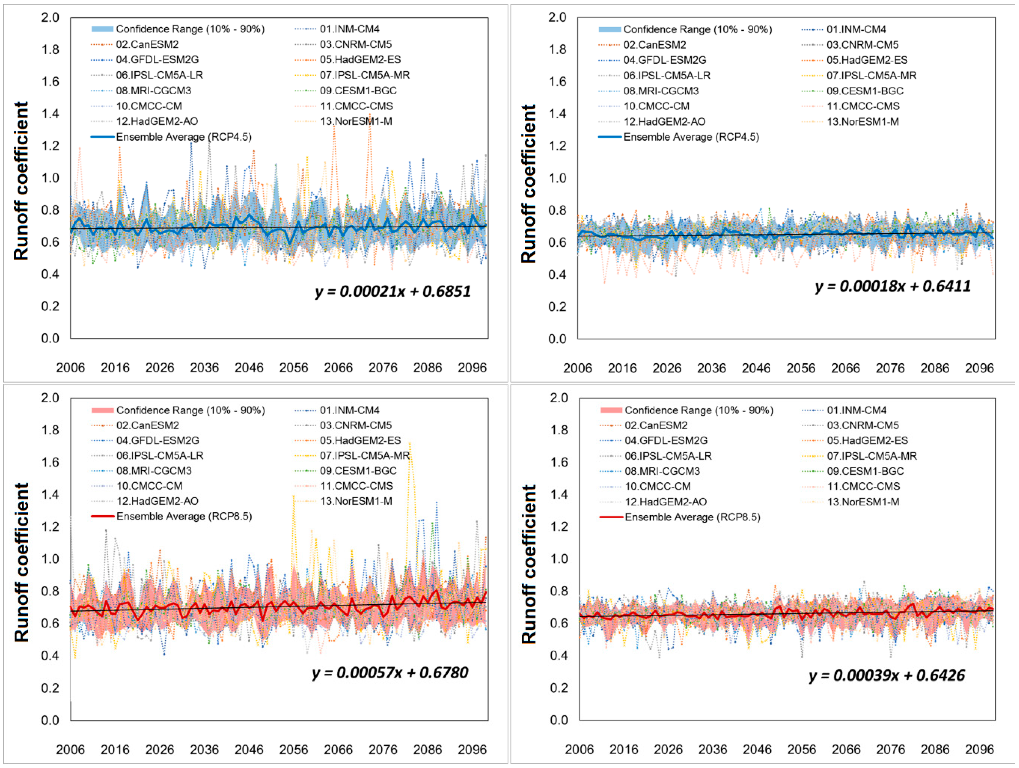
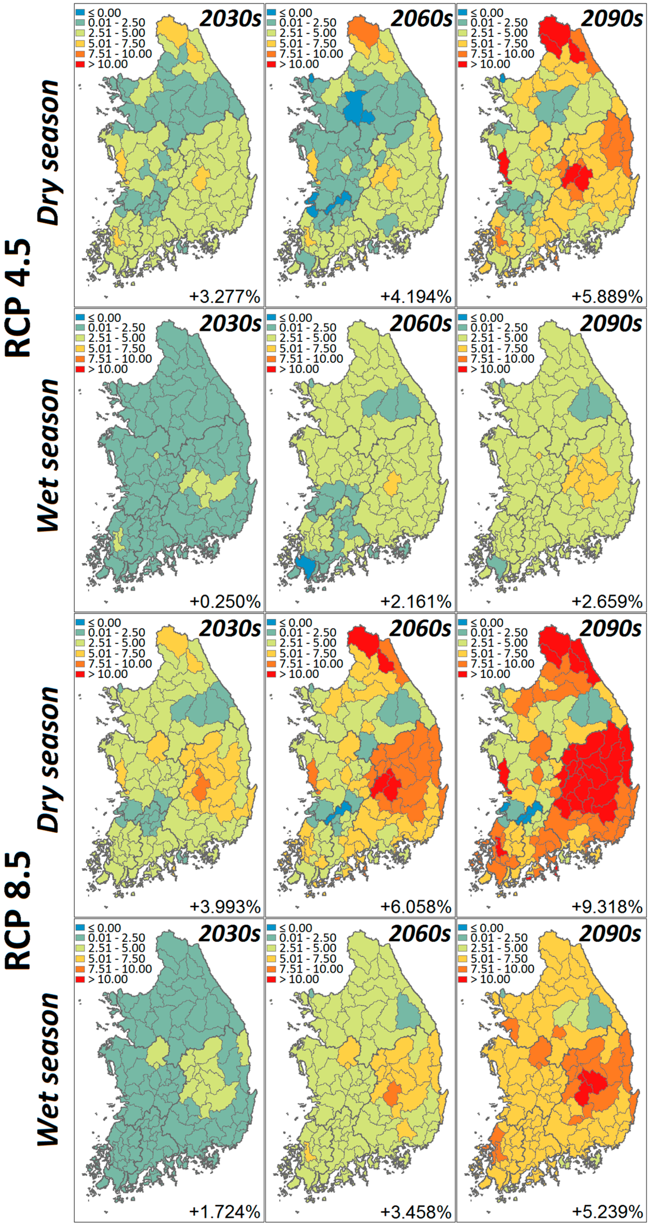
The present study has examined the trend of the runoff coefficient throughout South Korea, in addition to five major basins during the future period of 2006 to 2099, and its variations in three future periods referred to the baseline (1976–2005). The results show a slightly increasing trend of the total runoff coefficient in both the dry and the wet seasons. Specifically, the change rate of the runoff coefficient during the dry season is expected to be higher than that during the wet season. A sharp contrast was found between the trends of the two components of the runoff coefficient. Specifically, the surface runoff coefficient is projected to decrease in the dry season and strongly increase in the wet season. In contrast, groundwater runoff always shows an increasing trend in the dry season but a decreasing trend in the wet season in both RCP scenarios. This is expected due to the impact of the difference in the amount of water remaining in the surface and vadose layers on the surface runoff coefficient and groundwater runoff coefficient. A higher uncertainty of the runoff coefficient during the dry season is found due to the dominance of the groundwater component in the total runoff coefficient, as it is driven by numerous uncertain processes and variables. The results also reveal a fluctuation of the runoff coefficient during the 21st century, which is probably related to the influence of planetary oscillation on the variation in its dominant factors from the interannual to decadal scale.
Among the five major basins, the Nakong River basin is expected to have the highest increase rate of the runoff coefficient, while the lowest increase rate during the dry season is found in the Geum River basin, the lowest increasing rate during the wet season is found in the Seomjin River basin in all future periods. The difference in the spatial distribution of the runoff coefficient is associated with characteristics of soil, topographic slope, and land cover/land use in each major basin.
The variation in the total runoff coefficient shows a low correlation with the spatial change in land cover/land use over 109 subbasins; specifically, the correlation of the total runoff coefficient in the wet season is found to be higher than that in the dry season. The impact of land cover/land use on the total runoff coefficient is also found to change over time with the increase in temperature and precipitation during the 21st century. This impact is found to be different, even inconsistent, in the case of forest, orchard, and paddy land. The difference is expected due to variations in evapotranspiration and soil water volume jointly with the contribution rate of each component of streamflow.
The variation in the runoff coefficient could be very helpful for regions facing water-related issues, especially in the context of climate change. As mentioned, to develop a construction plan to prevent flooding, the runoff coefficient is required as a critical parameter for designing. However, at present, this coefficient is only derived by traditional methods without considering the impacts of climate change. Hence, the results provide an insightful analysis of variation in the runoff coefficient in the future, which needs to be considered carefully when planning or developing a construction project to adapt to climate change. Furthermore, the increase in the runoff coefficient probably predicts a decrease in the water storage capacity of the soil, leading to an increase in hydrologic drought conditions in South Korea. The outcomes of the study are not only of importance in understanding the impacts of climate change on hydrological processes and water balance for a catchment but also of significance for water resource management.


