Applying 3D Geostatistical Simulation to Improve the Groundwater Management Modelling of Sedimentary Aquifers: The Case of Doñana (Southwest Spain)


Abstract
1. Introduction
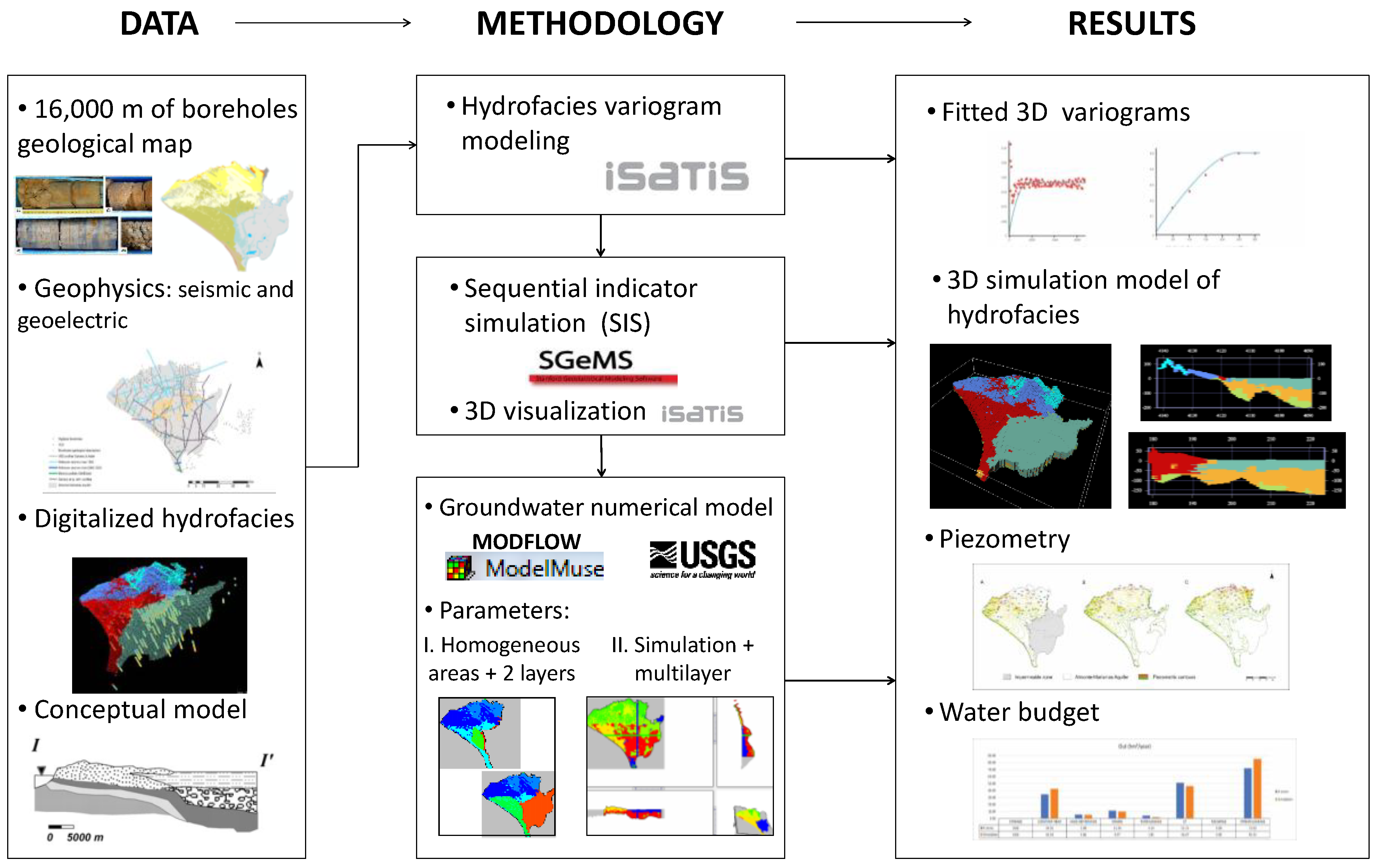
2. Materials and Methods
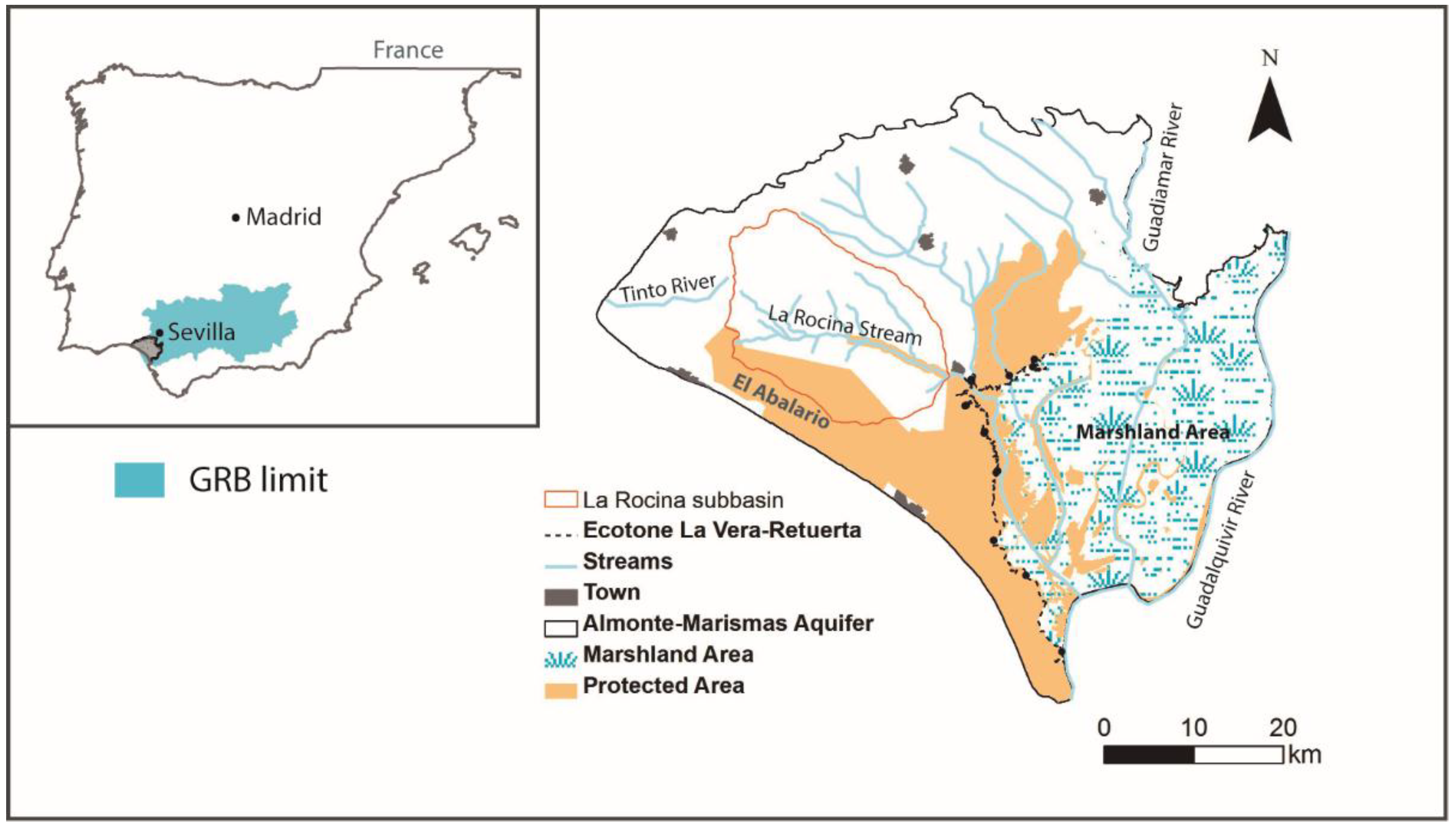
2.1. Study Site
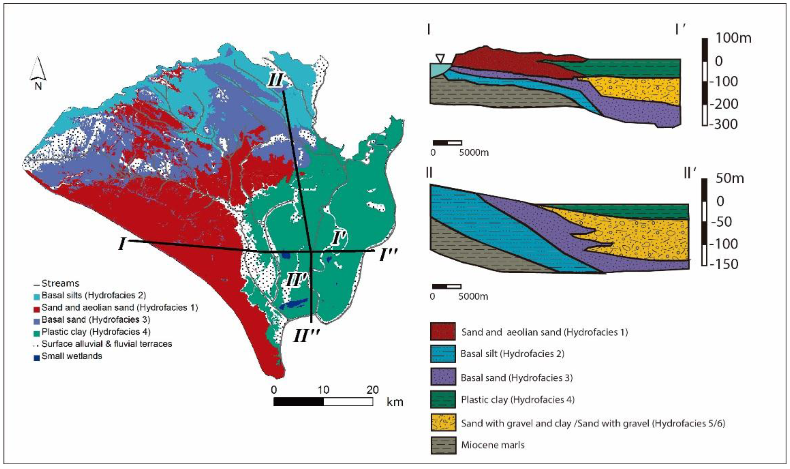
2.2. Hydrofacies Model
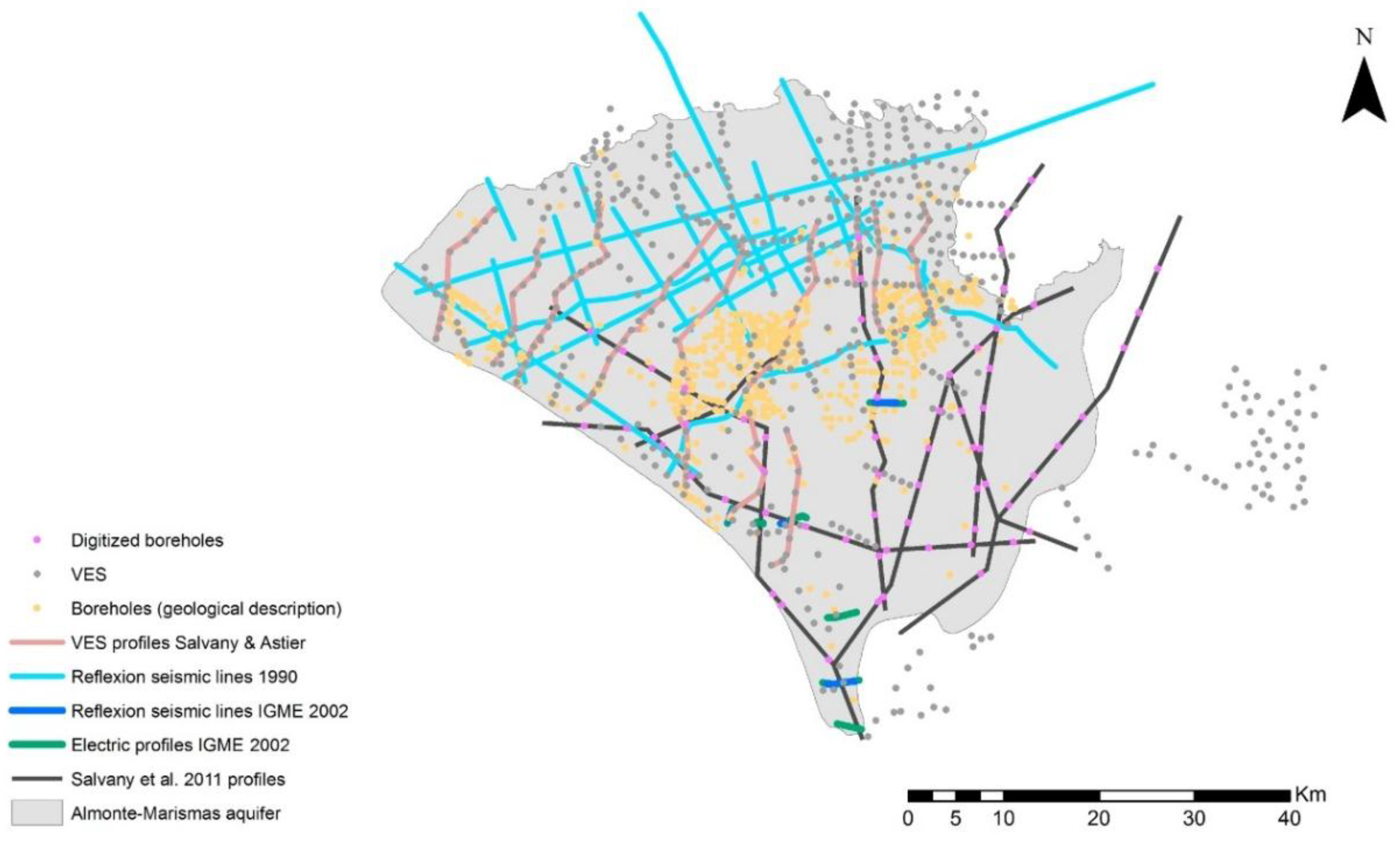
2.3. Geological and Geophysical Data
2.4. Variogram Modelling
2.5. Sequential Indicator Simulation (SIS)
2.6. Groundwater Modelling with MODFLOW and Model Muse GUI
3. Results
3.1. Geostatistical Model
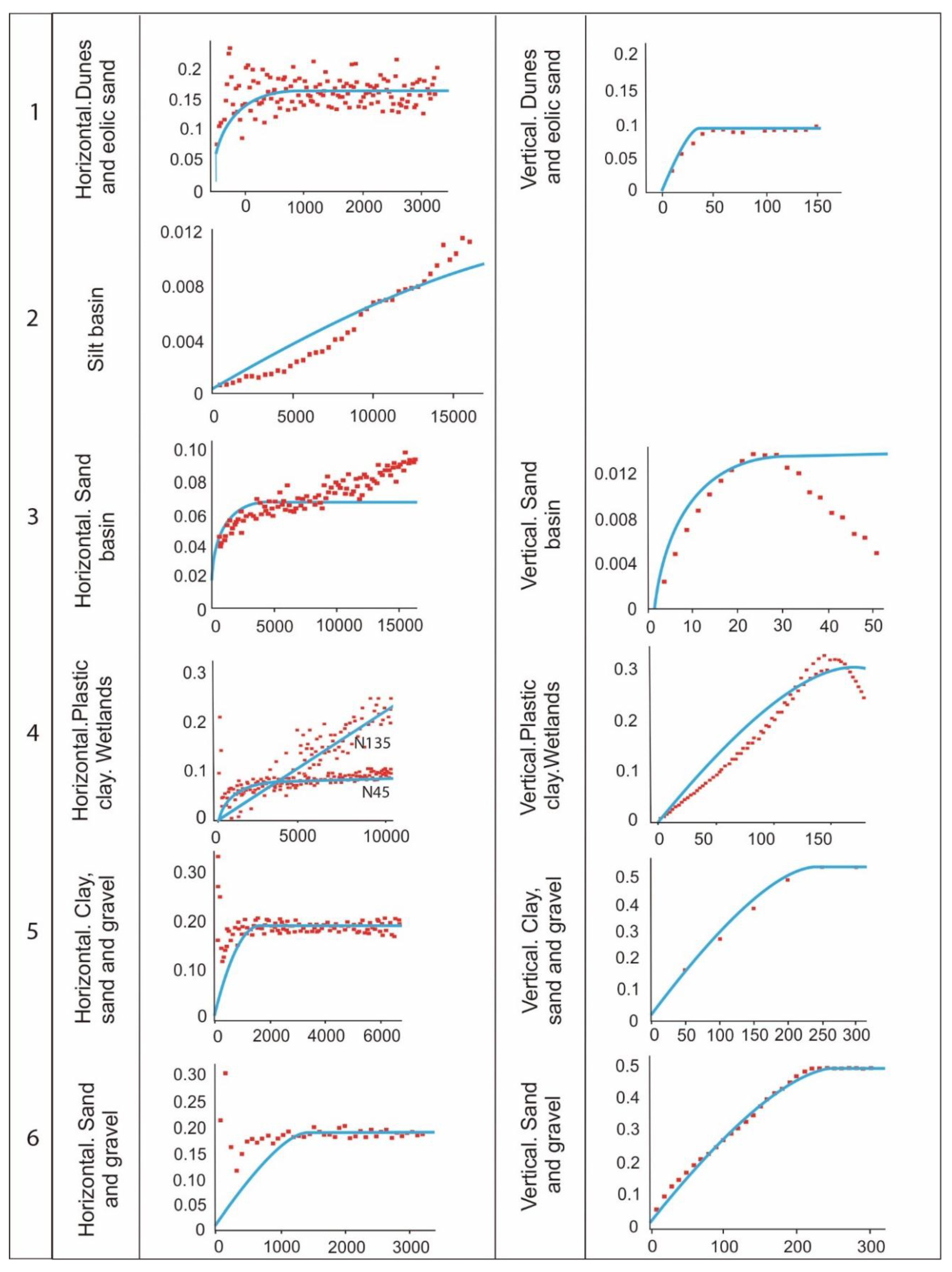
3.1.1. Variograms
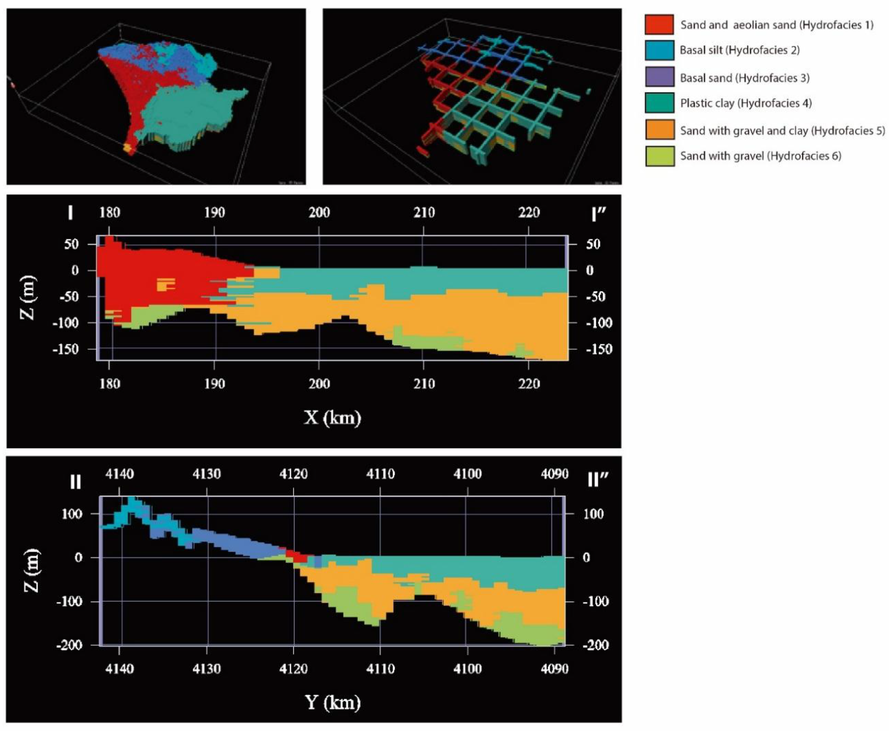
3.1.2. Sequential Indicator Simulation
3.2. Groundwater Flow Model
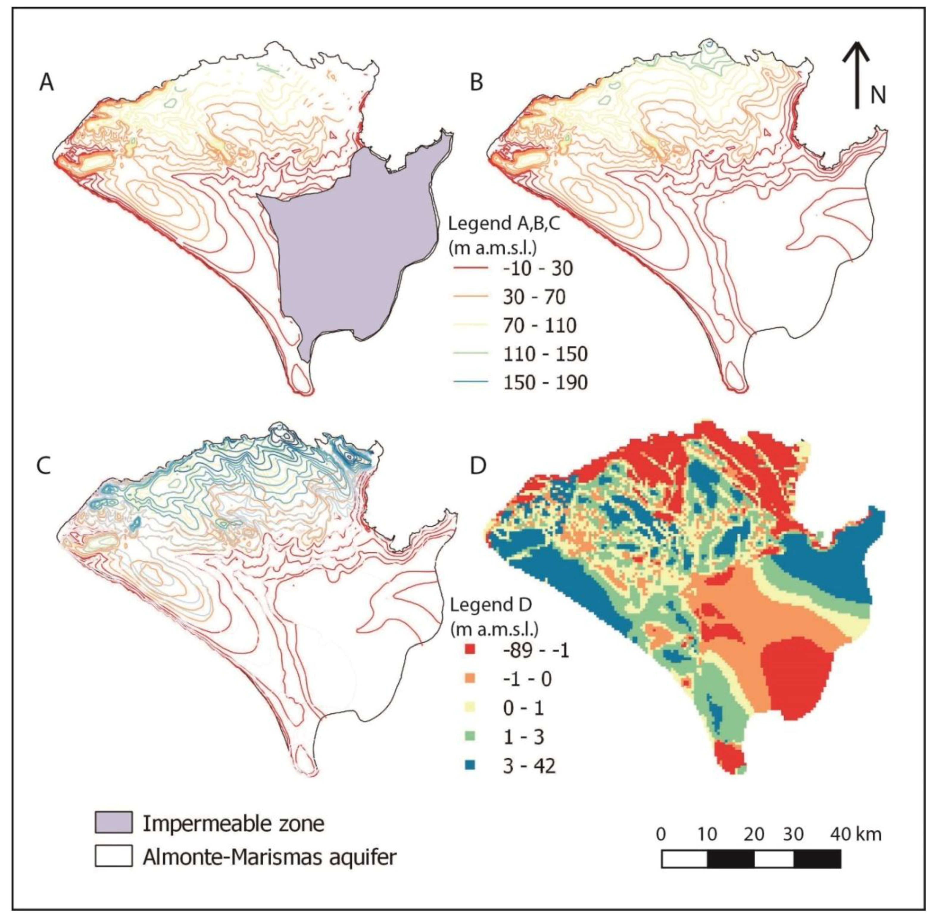
3.2.1. Piezometry
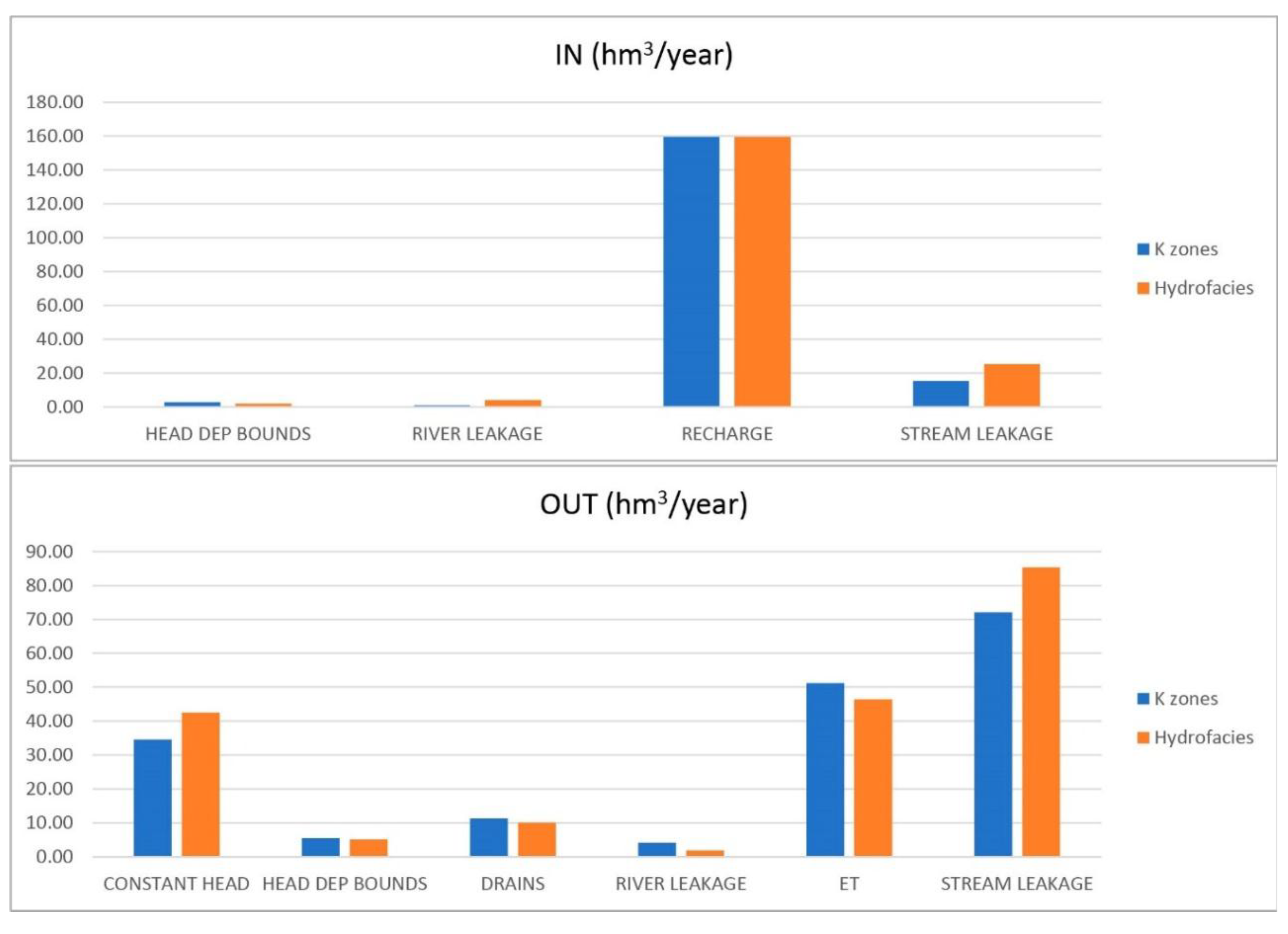
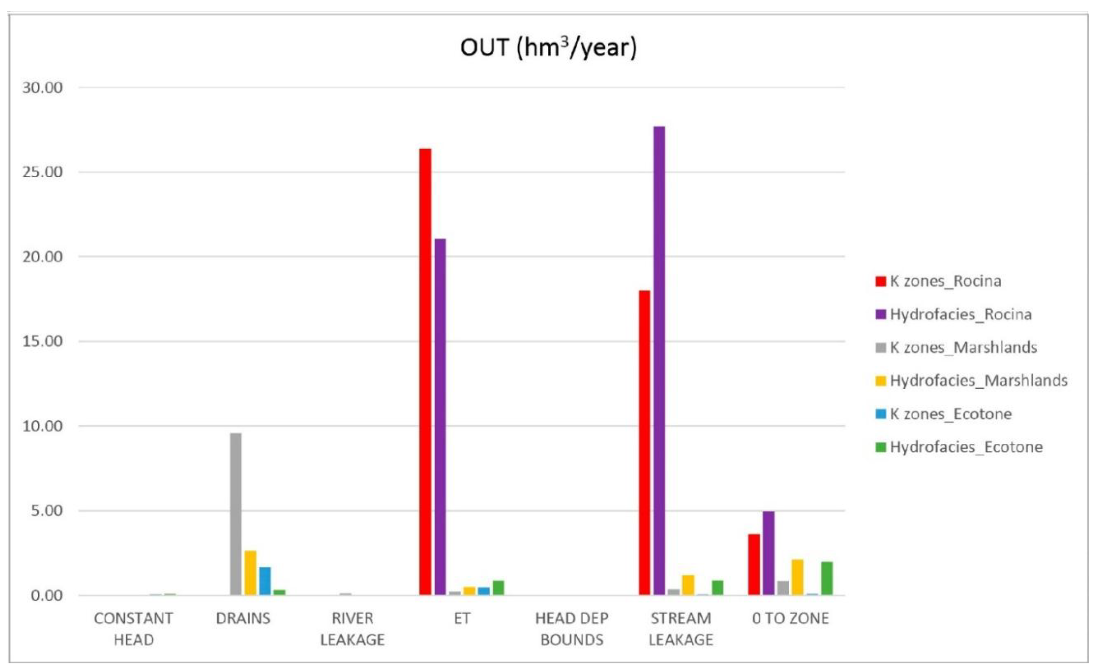
3.2.2. Water Budget
4. Discussion
4.1. Variogram Models
4.2. Geostatisical Simulation
4.3. Groundwater Flow Model
5. Conclusions
Author Contributions
Funding
Acknowledgments
Conflicts of Interest
References
- Guardiola-Albert, C.; Jackson, C.R. Potential impacts of climate change on groundwater supplies to the Doñana wetland, Spain. Wetlands 2011, 31, 907–920. [Google Scholar] [CrossRef]
- Green, A.J.; Alcorlo, P.; Peeters, E.T.; Morris, E.P.; Espinar, J.L.; Bravo-Utrera, M.A.; Bustamante, J.; Díaz-Delgado, R.; Koelmans, A.; Mateo, R.; et al. Creating a safe operating space for wetlands in a changing climate. Front. Ecol. Environ. 2017, 15, 99–107. [Google Scholar] [CrossRef]
- Sánchez-Vila, X.; Fernández-García, D. Gestión de los recursos hídricos: Los modelos hidrogeológicos como herramienta auxiliar. Enseñanza de las ciencias de la tierra 2007, 15, 250–256. [Google Scholar]
- Instituto Geológico y Minero de España (IGME). Primer Informe sobre el Modelo Matemático del Acuífero de Almonte Marismas; Instituto Geológico y Minero de España: Madrid, Spain, 1975. [Google Scholar]
- Instituto Geológico y Minero de España (IGME). Modelo Matemático Bidimensional del Sistema Acuífero n° 27: Unidad Almonte-Marismas, 1982. Available online: http://info.igme.es/SidPDF/018000/726/18726_0001.pdf (accessed on 22 September 2018).
- Instituto Geológico y Minero de España (IGME). Modelo Matemático del Acuífero de Almonte-Marismas (Parque Nacional de Doñana); Instituto Geológico y Minero de España: Madrid, Spain, 1994. [Google Scholar]
- Instituto Geológico y Minero de España (IGME). Modelo Regional de Flujo Subterráneo del Sistema Acuífero Almonte-Marismas y su Entorno; Instituto Geológico y Minero de España: Madrid, Spain, 1999. [Google Scholar]
- Universitat Politècnica de Catalunya (UPC). Regional Groundwater Flow in the Almonte-Marismas Aquifer; Groundwater Hydrology Group of the Technical University of Catalonia and Geological Institute: Madrid, Spain, 1999; 114p. [Google Scholar]
- Instituto Geológico y Minero de España (IGME). Modelo matemático del acuífero Almonte—Marismas: Actualización y realización en Visual Modflow, 2005. Available online: Https://www.researchgate.net/publication/264229860_Modelo_matematico_revisado_del_acuifero_Almonte-Marismas_aplicacion_a_distintas_hipotesis_de_gestion (accessed on 25 September 2018).
- Instituto Geológico y Minero de España (IGME). Mejora del Modelo Matemático del Acuífero Almonte-Marismas Como Apoyo a la Gestión de los Recursos Hídricos: Estimación de la Recarga, Modelo Estocástico y Actualización; Instituto Geológico y Minero de España: Madrid, Spain, 2009. [Google Scholar]
- Instituto Geológico y Minero de España (IGME). Proyecto Para la Actualización del Modelo Numérico (Visual Modflow 4.3, Igme 2007) del Sistema Acuífero Almonte-Marismas, Como Apoyo para el Desarrollo de un Modelo de Gestión y Uso Sostenible del Acuífero en el Ámbito de Doñana (Huelva-Sevilla); Instituto Geológico y Minero de España: Madrid, Spain, 2011. [Google Scholar]
- Jankowski, J.; Beck, P. Aquifer heterogeneity: Hydrogeological and hydrochemical properties of the Botany Sands aquifer and their impact on contaminant transport. Aust. J. Earth Sci. 2000, 47, 45–64. [Google Scholar] [CrossRef]
- Nœtinger, B.; Artus, V.; Zargar, G. The future of stochastic and upscaling methods in hydrogeology. Hydrogeol. J. 2005, 13, 184–201. [Google Scholar] [CrossRef]
- De Marsily, G.; Delay, F.; Gonçalvès, J.; Renard, P.; Teles, V.; Violette, S. Dealing with spatial heterogeneity. Hydrogeol. J. 2005, 13, 161–183. [Google Scholar] [CrossRef]
- Watson, C.; Richardson, J.; Wood, B.; Jackson, C.; Hughes, A. Improving geological and process model integration through TIN to 3D grid conversion. Comput. Geosci. 2015, 82, 45–54. [Google Scholar] [CrossRef]
- Klingbeil, R.; Kleineidam, S.; Asprion, U.; Aigner, T.; Teutsch, G. Relating lithofacies to hydrofacies: Outcrop-based hydrogeological characterisation of Quaternary gravel deposits. Sediment. Geol. 1991, 129, 299–310. [Google Scholar] [CrossRef]
- Anderson, M.P. Hydrogeological facies models to delineate large scale spatial trends in glacial and glacio fluvial sediments. Geol. Soc. Am. Bull. 1989, 101, 501–511. [Google Scholar] [CrossRef]
- Comunian, A.; De Micheli, L.; Lazzati, C.; Felleti, F.; Giacobbo, F.; Giudici, M.; Bersezio, R. Hierarchical simulation of aquifer heterogeneity: Implications of different simulation settings on solute-transport modeling. Hydrogeol. J. 2016, 24, 319–334. [Google Scholar] [CrossRef]
- Seifert, D.; Jensen, J.L. Using sequential indicator simulation as a tool in reservoir description: Issues and uncertainties. Math. Geol. 1991, 31, 527–550. [Google Scholar] [CrossRef]
- Renard, P. Stochastic Hydrogeology: What Professionals Really Need? Groundwater 2007, 45, 531–541. [Google Scholar] [CrossRef] [PubMed]
- Pyrcz, M.J.; Deutsch, C.V. Geostatistical Reservoir Modeling, 2nd ed.; Oxford University Press: New York, NY, USA, 2014; p. 433. [Google Scholar]
- Fiori, A.; Cvetkovic, V.; Dagan, G.; Attinger, S.; Bellin, A.; Dietrich, P.; Zech, A.; Teutsch, G. Debates—Stochastic subsurface hydrology from theory to practice: The relevance of stochastic subsurface hydrology to practical problems of contaminant transport and remediation. What is characterization and stochastic theory good for? Water Resour. Res. 2016, 52, 9228–9234. [Google Scholar] [CrossRef]
- Dell’Arciprete, D.; Bersezio, R.; Felletti, F.; Giudici, M.; Comunian, A.; Renard, P. Comparison of three geostatistical methods for hydrofacies simulation: A test on alluvial sediments. Hydrogeol. J. 2012, 20, 299–311. [Google Scholar] [CrossRef]
- Alabert, F. Stochastic Imaging of Spatial Distributions Using Hard and Soft Information. Master’s Thesis, Department of Applied Earth Sciences, Stanford University, Stanford, CA, USA, 1987. [Google Scholar]
- Beucher, H.; Renard, D. Truncated Gaussian and derived methods. C. R. Geosci. 2016, 348, 510–519. [Google Scholar] [CrossRef]
- Deutsch, C.V.; Tran, T.T. FLUVSIM: A program for object-based stochastic modelling of fluvial depositional systems. Comput. Geosci. 2002, 28, 525–535. [Google Scholar] [CrossRef]
- Hu, L.Y.; Chugunova, T. Multiple-point geostatistics for modeling subsurface heterogeneity: A comprehensive review. Water Resour. Res. 2008, 44. [Google Scholar] [CrossRef]
- Gómez-Hernández, J.J.; Srivastava, R.M. ISIM3D: An ANSI-C three-dimensional multiple indicator conditional simulation program. Comput. Geosci. 1990, 16, 395–440. [Google Scholar] [CrossRef]
- Deutsch, C.V. A sequential indicator simulation program for categorical variables with point and block data: BlockSIS. Comput. Geosci. 2006, 32, 1669–1681. [Google Scholar] [CrossRef]
- Marini, M.; Felletti, F.; Bereta, G.P.; Terrenghi, J. Three Geostatistical Methods for Hydrofacies Simulation Ranked Using a Large Borehole Lithology Dataset from Venice Hinterland (NE Italy). Water 2018, 10, 844. [Google Scholar] [CrossRef]
- Salvany, J.M.; Custodio, E. Características litoestratigráficas de los depósitos pliocuaternarios del bajo Guadalquivir en el área de Doñana: Implicaciones hidrogeológicas. Rev. Soc. Geol. España 1995, 8, 21–31. [Google Scholar]
- Custodio, E.; Manzano, M.; Montes, C. Las aguas Subterráneas en Doñana. Aspectos Ecológicos y Sociales; Junta de Andalucía: Sevilla, España, 2009; 244p, ISBN 978-84-92807-19-2. [Google Scholar]
- Rodríguez-Ramirez, A.; Yáñez-Camacho, C.; Gascó, C.; Clemente-Salas, L.; Antón, M.P. Colmatación natural y antrópica de las marismas del Parque Nacional de Doñana: Implicaciones para su manejo y conservación. Cuaternario y Geomorfología 2005, 19, 37–48. [Google Scholar]
- Salvany, J.M.; Cruz-Larrasoaña, J.; Mediavilla, C.; Rebollo, A. Chronology and tectono-sedimentary evolution of the Upper Pliocene to Quaternary deposits of the lower Guadalquivir foreland basin, SW Spain. Sediment. Geol. 2011, 241, 22–39. [Google Scholar] [CrossRef]
- Roldán, F.J.; Rodríguez-Fernández, J.; Villalobos, M.; Lastra, J.; Díaz-Pinto, G.; Pérez Rodríguez, A.B. Mapa Geológico Digital Continuo E.1:50.000, Zonas Subbético, Cuenca del Guadalquivir y Campo de Gibraltar. In GEODE Mapa Geológico Digital continuo de España. Available online: http://info.igme.es/cartografiadigital/geologica/geodezona.aspx?Id=Z2600 (accessed on 22 May 2018).
- Instituto Geológico y Minero de España (IGME). Revisión de la Información Geofísica Existente en el Acuífero Almonte-Marismas (Doñana), 2007. Available online: http://info.igme.es/SidPDF/137000/833/137833_0000001.pdf (accessed on 22 May 2018).
- Instituto Geológico y Minero de España (IGME). Informe Técnico Sobre los Sondeos Mecánicos de Reconocimiento Geológico e Hidrogeológico Realizados en el Acuífero Almonte-Marismas; Instituto Geológico y Minero de España: Madrid, Spain, 2009. [Google Scholar]
- Matheron, G. Les Variables Régionalisées et leur Estimation. Une Application de la Théorie des Fonctions Aléatoires aux Sciences de la Nature; Masson: Paris, France, 1965; 306p. [Google Scholar]
- Trevisani, S.; Fabbri, P. Geostatistical modeling of heterogeneous site bordering the Venice Lagoon, Italy. Groundwater 2010, 48, 614–623. [Google Scholar] [CrossRef] [PubMed]
- Seifert, D.; Jensen, J.L. Object and pixel-based reservoir modeling of braided fluvial reservoir. Math. Geol. 2000, 32, 581–603. [Google Scholar] [CrossRef]
- Géovariances. Isatis Technical Ref.; ver. 2012.4; Geovariances & Ecole Des Mines De Paris: Avon Cedex, France, 2009. [Google Scholar]
- Remy, N.; Boucher, A.; Wu, J. Applied Geostatistics with SGeMS: A User’s Guide; Cambridge University Press: New York, NY, USA, 2009. [Google Scholar]
- Caers, J. Adding Local Accuracy to Direct Sequential Simulation. Mat. Geosci 2000, 32, 815–850. [Google Scholar] [CrossRef]
- Deutsch, C.V. Cleaning categorical variable (lithofacies) realizations with maximum a posteriori selection. Comput. Geosci. 1998, 24, 551–562. [Google Scholar] [CrossRef]
- Deutsch, C.V.; Journel, A.G. Geostatistical Software Library and User’s Guide; Oxford University Press: New York, NY, USA, 1998. [Google Scholar]
- Goovaerts, P. Stochastic simulation of cathegorical variables using a clasiffication algorithm and simulating annealing. Math. Geol. 1996, 28, 909–921. [Google Scholar] [CrossRef]
- Soares, A. Sequential indicator simulation with correction for local probabilities. Math. Geol. 1998, 30, 761–765. [Google Scholar] [CrossRef]
- Almeida, J.A. Stochastic simulation methods for characterization of lithoclasses in carbonate reservoirs. Earth Sci. Rev. 2010, 101, 250–270. [Google Scholar] [CrossRef]
- Lukjan, A.; Chalermyanont, T. Assesment of alluvial aquifer heterogeneity and development os stochastic hydrofacies models for the Hat Yai Basin in Sothern Thailand. Environ. Earth Sci. 2017, 76. [Google Scholar] [CrossRef]
- Harbaugh, A.W. MODFLOW-2005, The US Geological Survey Modular Ground-Water Model: The Ground-WaterFlow Process; Department of the Interior, Techniques and Methods 6–A16; U.S. Geological Survey: Reston, VA, USA, 2005. [Google Scholar]
- Winston, R.B. ModelMuse—A Graphical User Interface for MODFLOW–2005 and PHAST: U.S. Geological Survey Techniques and Methods 6–A29; U.S. Geological Survey: Reston, VA, USA, 1999; 52p. Available online: http://pubs.usgs.gov/tm/tm6A29 (accessed on 22 May 2018).
- Wackernagel, H. Multivariate Geostatistics: An Introduction with Applications, 2nd ed.; Springer: Berlin, Germany, 1998. [Google Scholar]
- Chiles, J.; Delfiner, P. Geostatistics: Modeling Spatial Uncertainty, 2nd ed.; John Wiley & Sons: New York, NY, USA, 1999; 734p, ISBN 978-0-470-18315-1. [Google Scholar]
- Salvany, J.M.; Mediavilla, C.; Rebollo, A. Las formaciones Plio-Cuaternarias de El Abalario en el litoral de la provincia de Huelva (España). Estudios Geológicos 2010, 66. [Google Scholar] [CrossRef]
- Gringarten, E.; Deutsch, C.V. Methodology for Improved Variogram Interpretation and Modeling for Petroleum Reservoir Characterization. In Proceedings of the SPE Annual Technical Conference and Exhibition, Houston, TX, USA, 3–6 October 1999; Society of Petroleum Engineers: Houston, TX, USA, 1999. [Google Scholar]
- Gringarten, E.; Deutsch, C.V. Teacher’s Aide. Variogram Interpretation and Modeling. Math. Geol. 2001, 33, 507–534. [Google Scholar] [CrossRef]
- Johnson, N.M.; Dreiss, S.J. Hydrostratigraphic interpretation using indicator geostatistics. Water Resour. Res. 1989, 25, 2501–2510. [Google Scholar] [CrossRef]
- Li, L.; Srinivasan, S.; Zhou, H.; Gomez-Hernandez, J. Two-point or multiple-point statistics? A comparison between the ensemble Kalman filtering and the ensemble pattern matching inverse methods. Adv Water Resour 2015, 86, 297–310. [Google Scholar] [CrossRef]
- Li, L.; Zhou, H.; Gómez-Hernández, J.J. Transport upscaling using multi-rate mass transfer in three-dimensional highly heterogeneous porous media. Adv. Water Resour. 2011, 34, 478–489. [Google Scholar] [CrossRef]
- Zhou, H.; Li, L.; Gómez-Hernández, J.J. Three-dimensional hydraulic conductivity upscaling in groundwater modeling. Comput. Geosci. 2010, 36, 1224–1235. [Google Scholar] [CrossRef]
- Li, L.; Zhou, H.; Gómez-Herández, J.J. A comparative study of three-dimensional hydraulic conductivity upscaling at the macro-dispersion experiment (MADE) site, Columbus Air Force Base, Mississipi (USA). J. Hydrol. 2011, 278–293. [Google Scholar] [CrossRef]
- Serrano, L.; Reina, M.; Martín, G.; Reyes, I.; Arechedera, A.; León, D.; Toja, J. The aquatic systems of Doñana (SW Spain): Watersheds and frontiers. Limnetica 2006, 25, 11–32. [Google Scholar]
- Sherif, M.; Singh, V.P. Effect of climate change on sea water intrusion in coastal aquifers. Hydrol. Process. 1999, 13, 1277–1287. [Google Scholar] [CrossRef]
- Confederación Hidrográfica del Guadalquivir (CHG). Plan Hidrológico de la Demarcación Hidrográfica del Guadalquivir; Segundo ciclo de planificación: 2016-2021.2015; CHG: Sevilla, Spain, 2015. [Google Scholar]
- WWW. Salvemos Doñana del Peligro a la Prosperidad. 2016. Available online: http://awsassets.panda.org/downloads/wwf_dalberg_salvemos_donana_lr.pdf (accessed on 22 May 2018).


| Hydrofacies Code | Lithology | Kx = Ky | Kz |
|---|---|---|---|
| 1 | Dunes and aeolic sand | 1.6 | 1.6 |
| 2 | Silt basin | 0.15 | 0.015 |
| 3 | Sand basin | 0.7 | 0.07 |
| 4 | Plastic clay, wetlands | 1.67 × 10⁻³ | 1.67 × 10⁻⁵ |
| 5 | Clay, sand, and gravel | 0.3 | 0.03 |
| 6 | Sand and gravel | 10 | 1 |
| Hydrofacies Code | Direction | Model | Nugget Effect | Sill | Range |
|---|---|---|---|---|---|
| 1 | Horizontal 0° | Spherical | 0 | 0.09 | 150 |
| 1 | Vertical | Spherical | 0 | 0.01 | 47 |
| 2 | Horizontal (omnidirectional) | Spherical | 0 | 0.0045 | 15,000 |
| 3 | Horizontal 0° | Spherical | 0 | 0.014 | 1500 |
| 3 | Vertical | Exponential | 0 | 0.05 | 900 |
| 4 | Horizontal 45° | Exponential | 0 | 0.06 | 7000 |
| 4 | Horizontal 135° | Power | 0 | 0.2 | 15,000 |
| 4 | Vertical | Gaussian | 0 | 0.29 | 175 |
| 5 | Horizontal 0° | Exponential | 0 | 0.15 | 2400 |
| 5 | Vertical | Exponential | 0 | 0.13 | 800 |
| 6 | Horizontal 0° | Exponential | 0 | 0.1 | 500 |
| 6 | Vertical | Spherical | 0 | 0.4 | 300 |
© 2018 by the authors. Licensee MDPI, Basel, Switzerland. This article is an open access article distributed under the terms and conditions of the Creative Commons Attribution (CC BY) license (http://creativecommons.org/licenses/by/4.0/).
Share and Cite
Naranjo-Fernández, N.; Guardiola-Albert, C.; Montero-González, E. Applying 3D Geostatistical Simulation to Improve the Groundwater Management Modelling of Sedimentary Aquifers: The Case of Doñana (Southwest Spain). Water 2019, 11, 39. https://doi.org/10.3390/w11010039
Naranjo-Fernández N, Guardiola-Albert C, Montero-González E. Applying 3D Geostatistical Simulation to Improve the Groundwater Management Modelling of Sedimentary Aquifers: The Case of Doñana (Southwest Spain). Water. 2019; 11(1):39. https://doi.org/10.3390/w11010039
Chicago/Turabian StyleNaranjo-Fernández, Nuria, Carolina Guardiola-Albert, and Esperanza Montero-González. 2019. "Applying 3D Geostatistical Simulation to Improve the Groundwater Management Modelling of Sedimentary Aquifers: The Case of Doñana (Southwest Spain)" Water 11, no. 1: 39. https://doi.org/10.3390/w11010039
APA StyleNaranjo-Fernández, N., Guardiola-Albert, C., & Montero-González, E. (2019). Applying 3D Geostatistical Simulation to Improve the Groundwater Management Modelling of Sedimentary Aquifers: The Case of Doñana (Southwest Spain). Water, 11(1), 39. https://doi.org/10.3390/w11010039