Evaluation of a Weathered Rock Aquifer Using ERT Method in South Guangdong, China


 ,
,
Abstract
1. Introduction
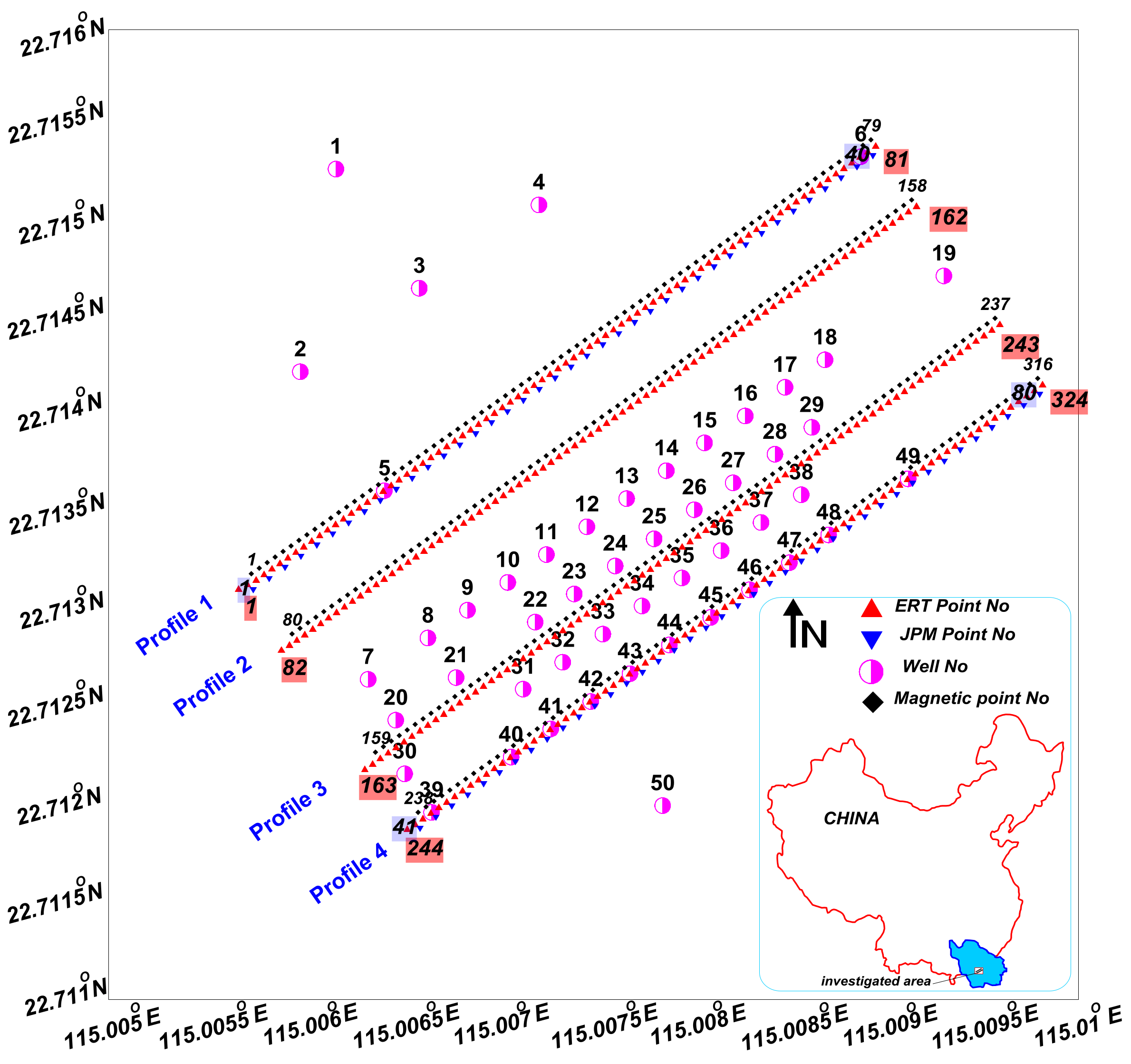
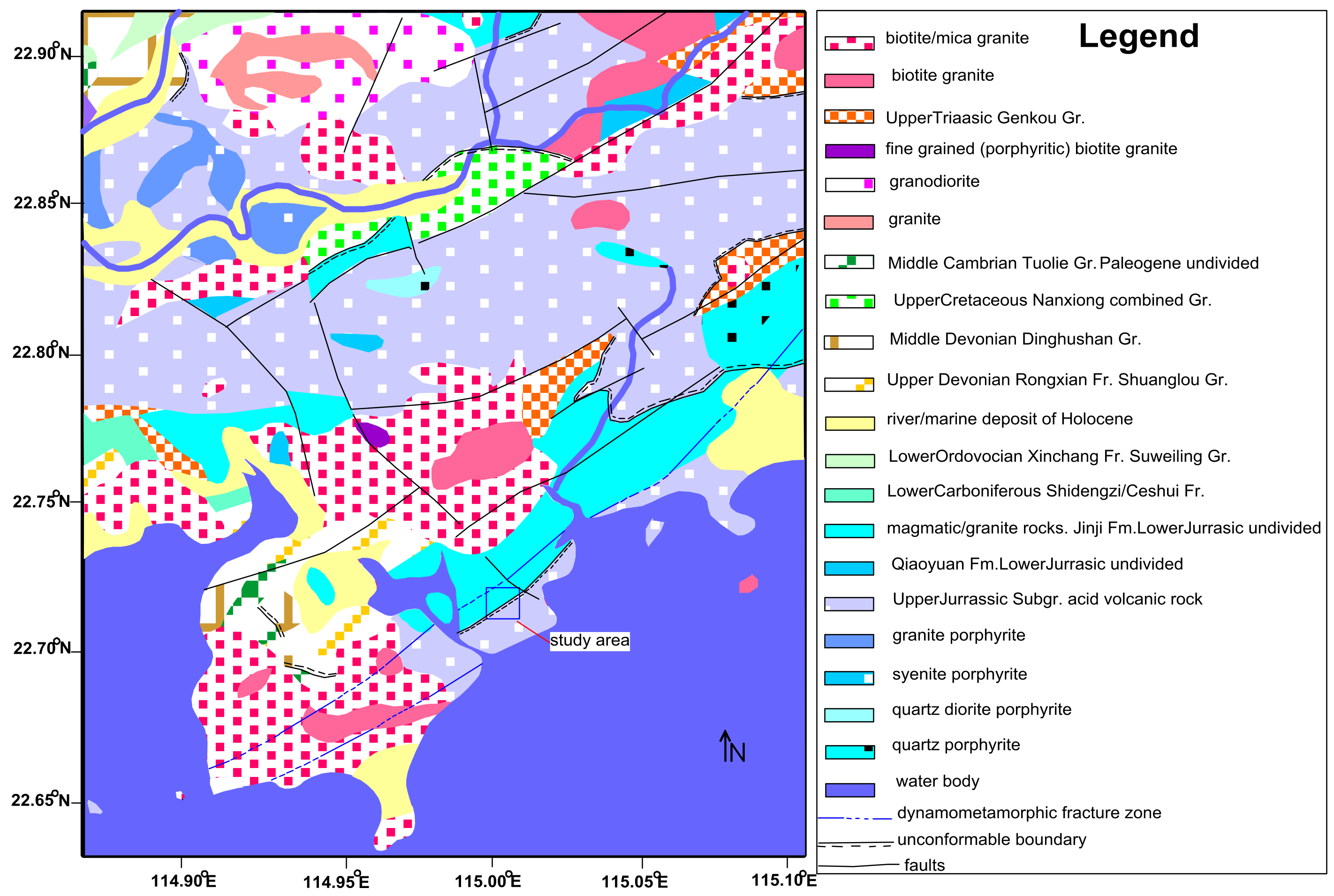
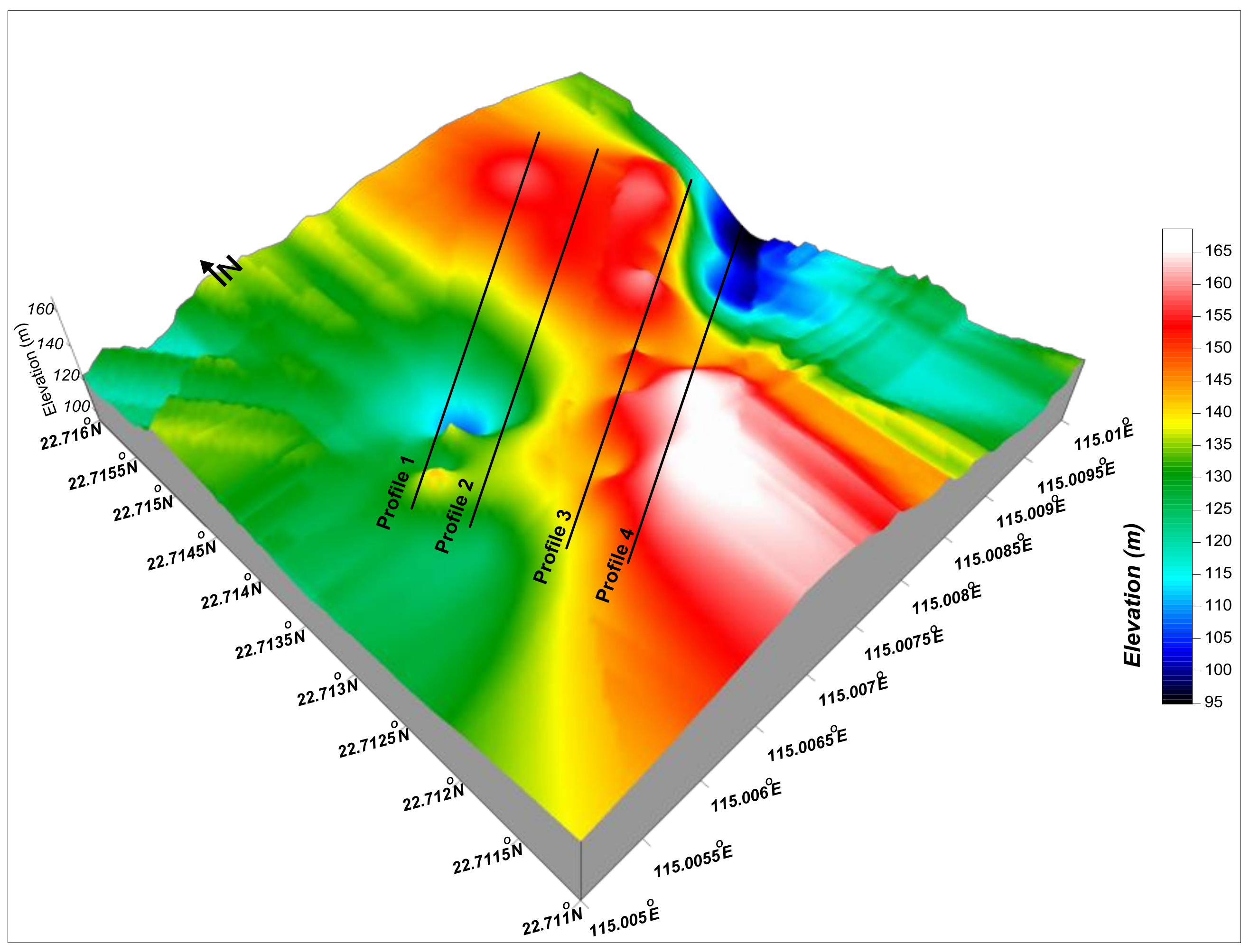
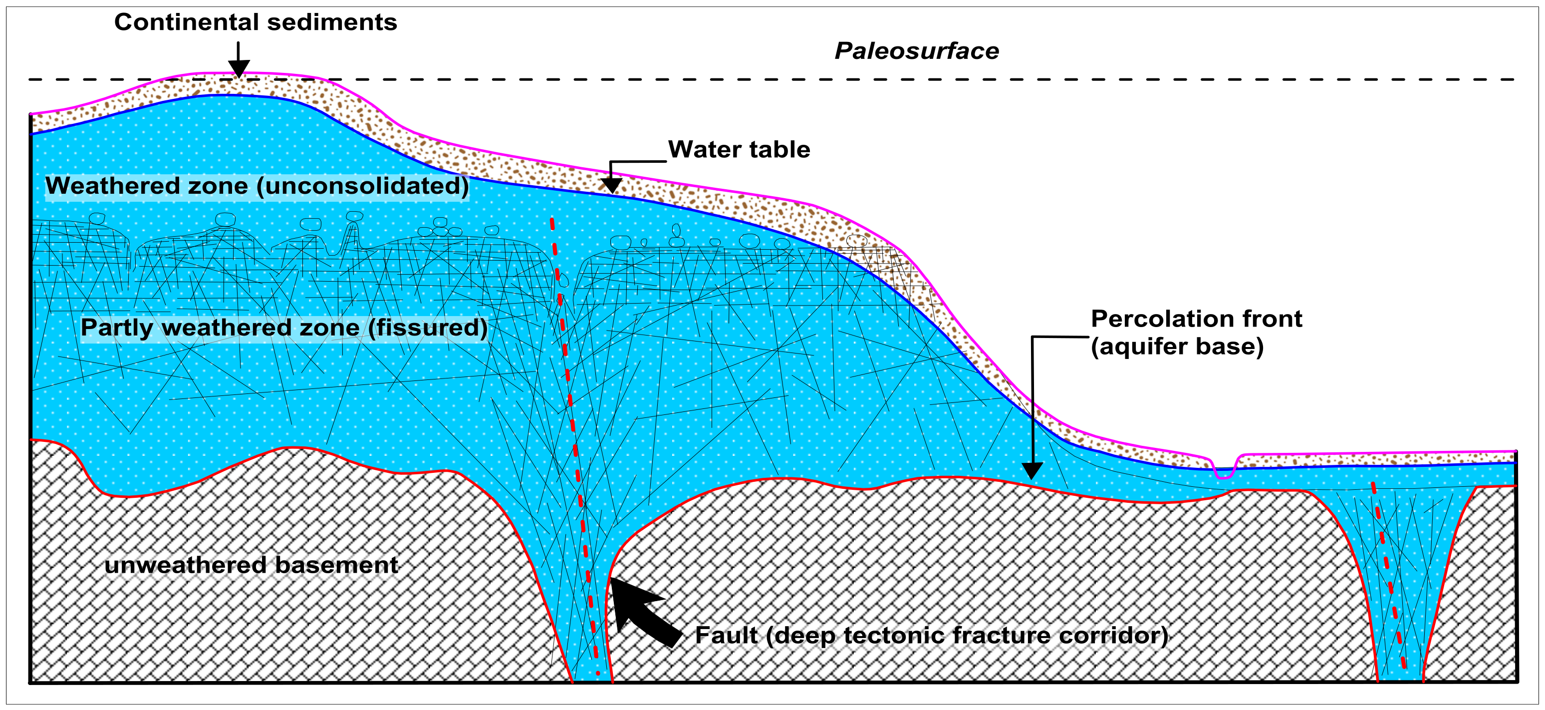
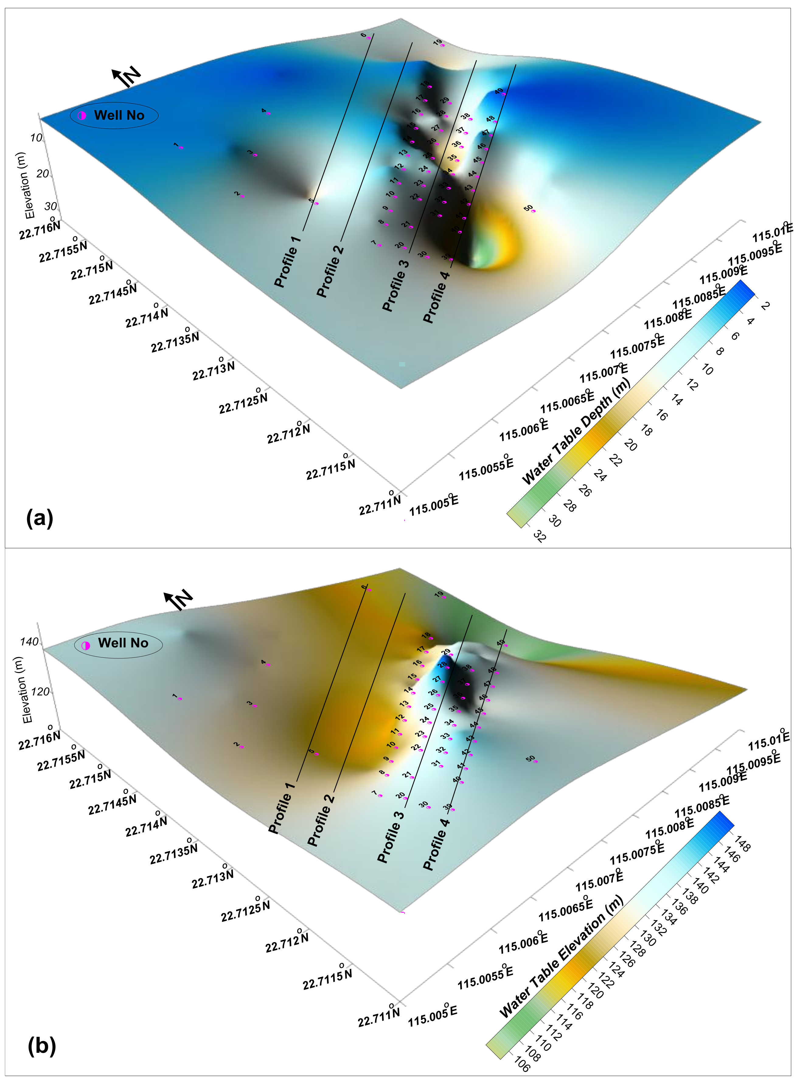
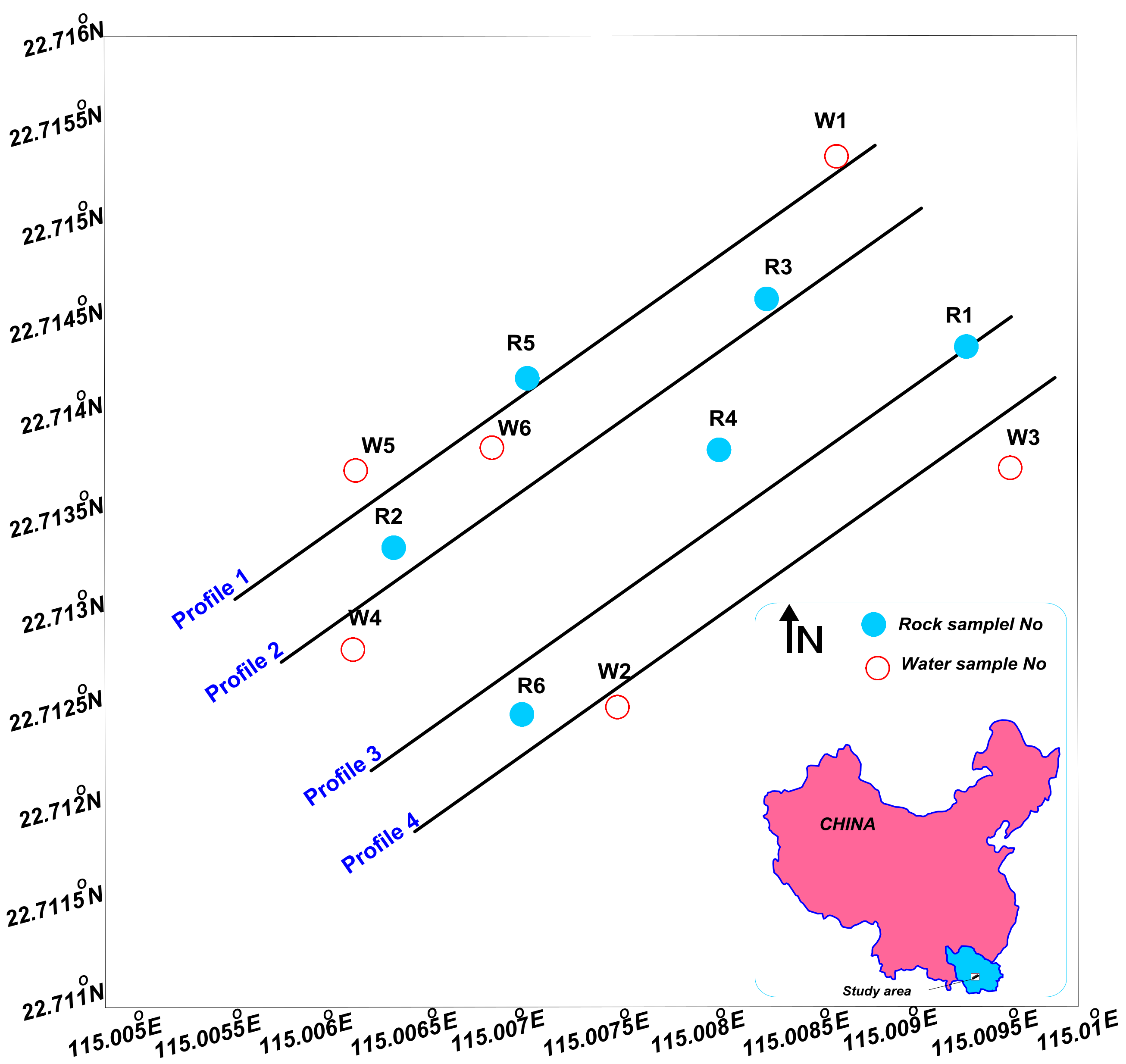
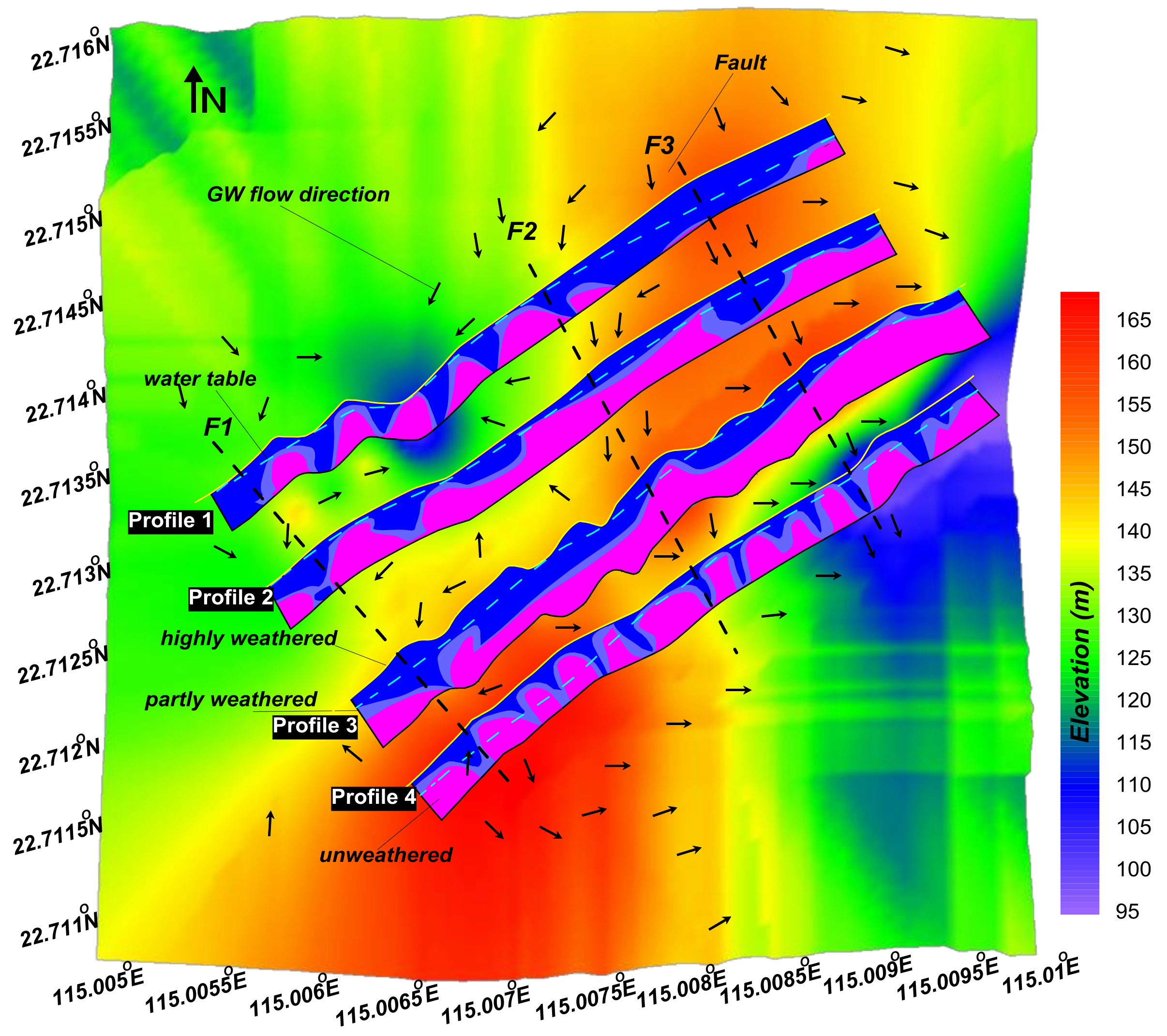
2. Study Area and Hydrogeological Setting
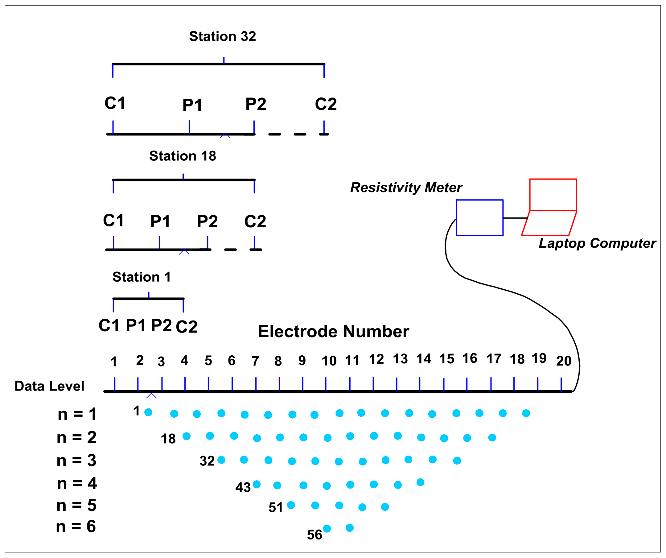
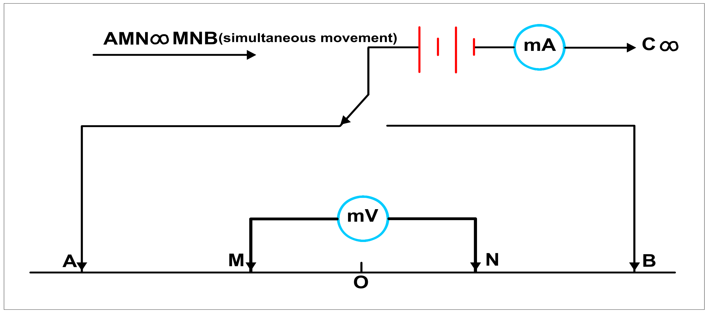
3. Materials and Methods
- i = iteration number
- Ji = Jacobian matrix of partial derivatives
- gi = discrepancy vector
- λi = damping factor
- pi = perturbation vector to the model parameters for the ith iteration
- C = 2D flatness filter
4. Results
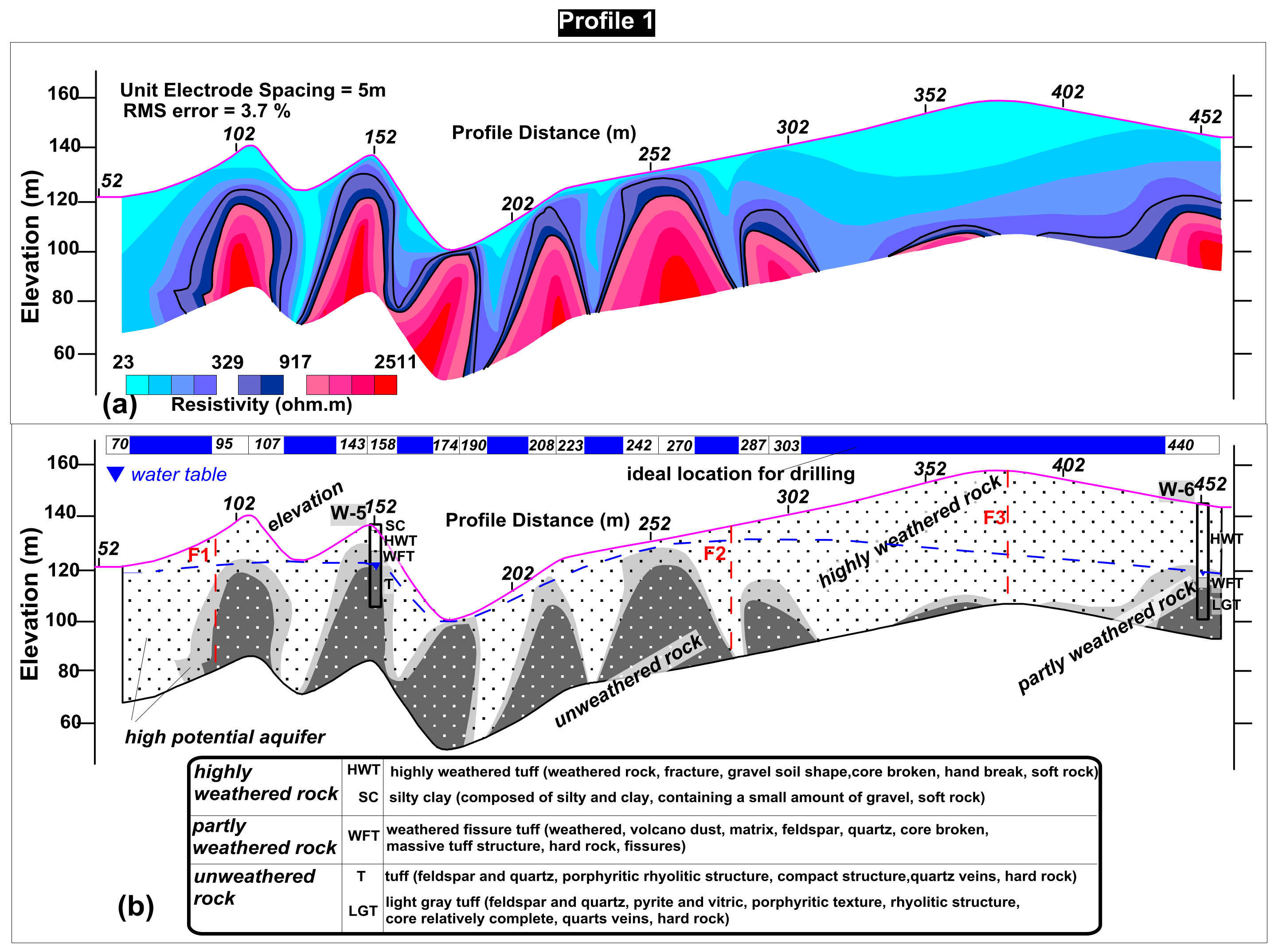
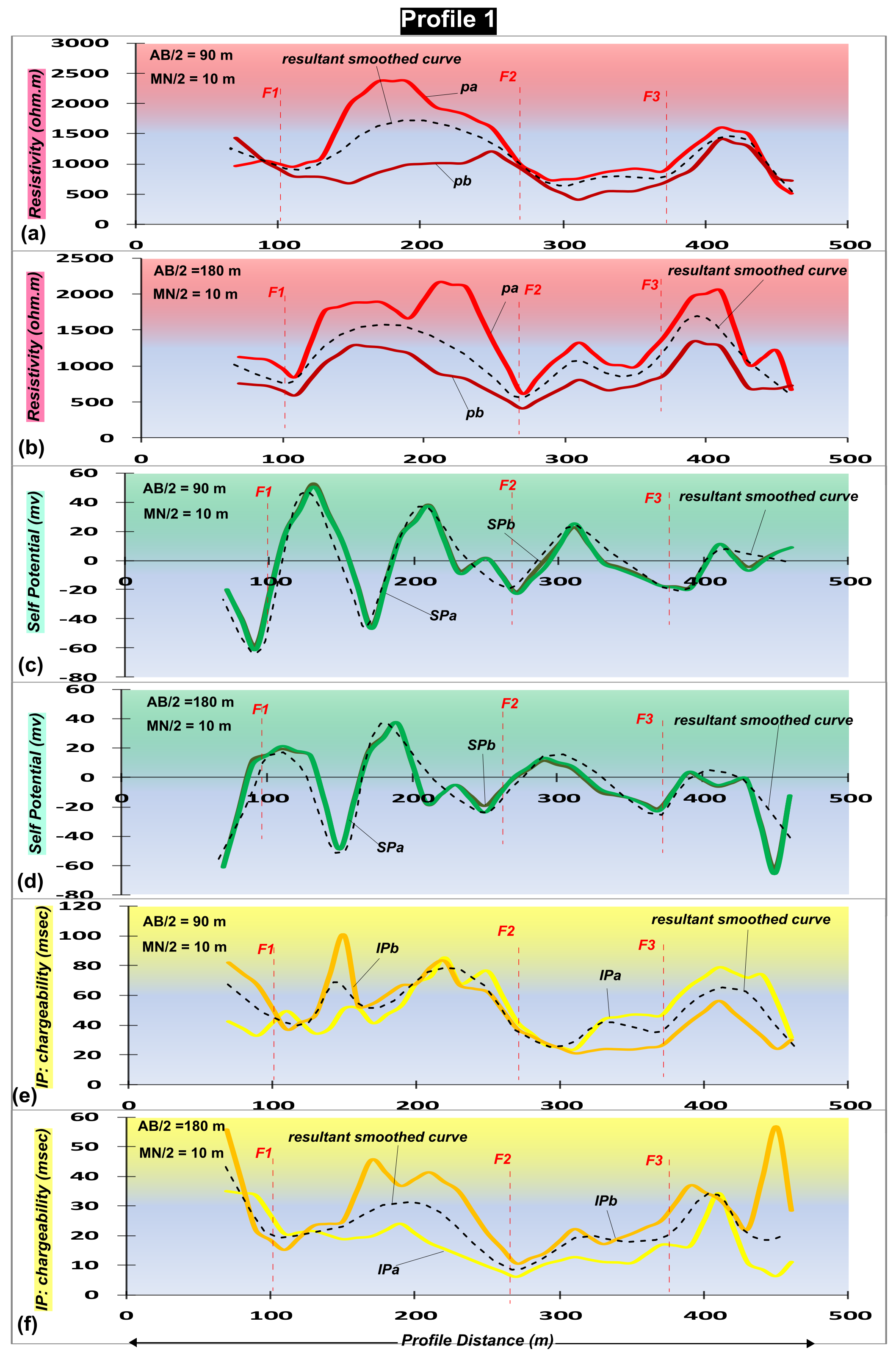
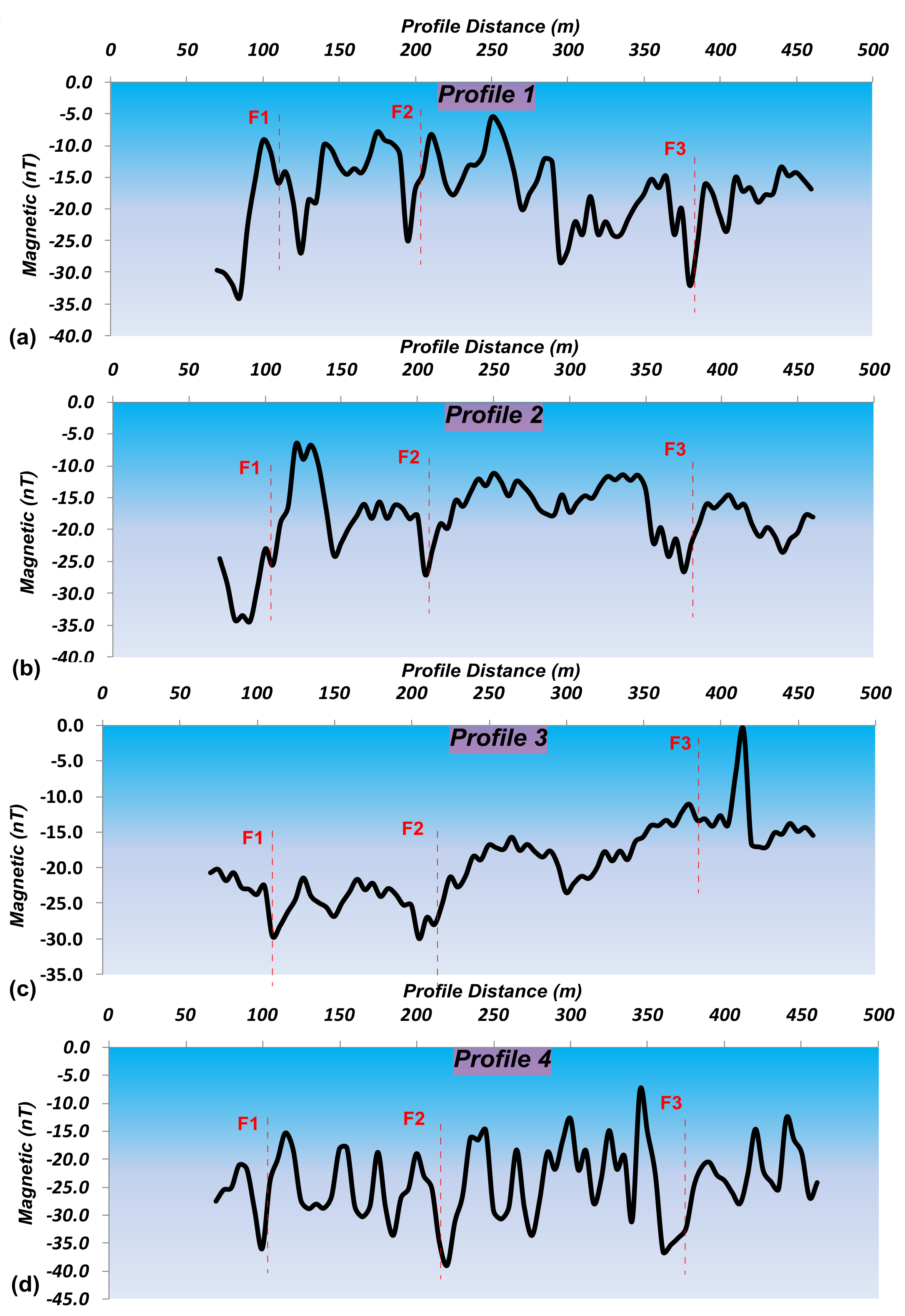
4.1. Profile 1
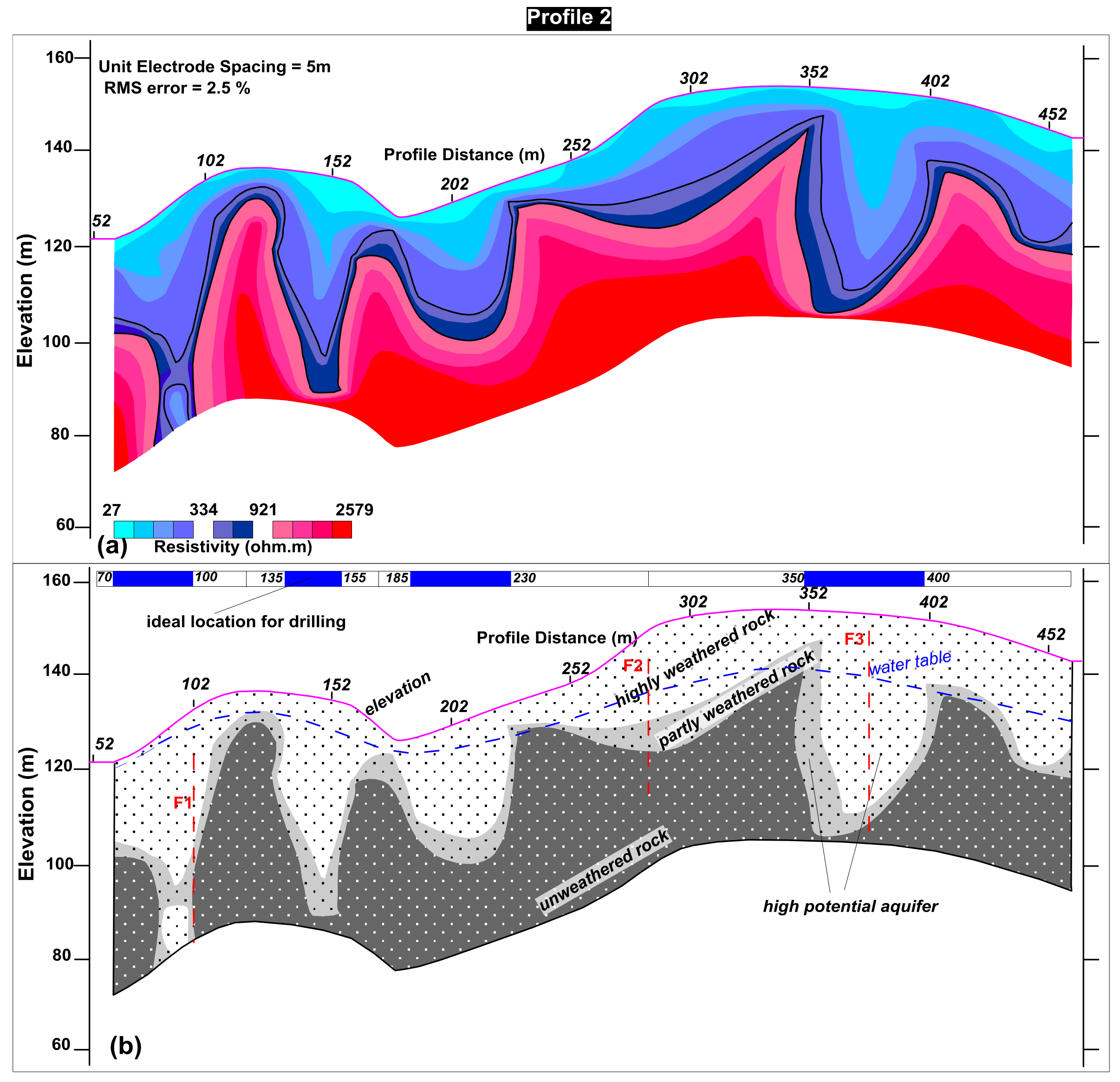
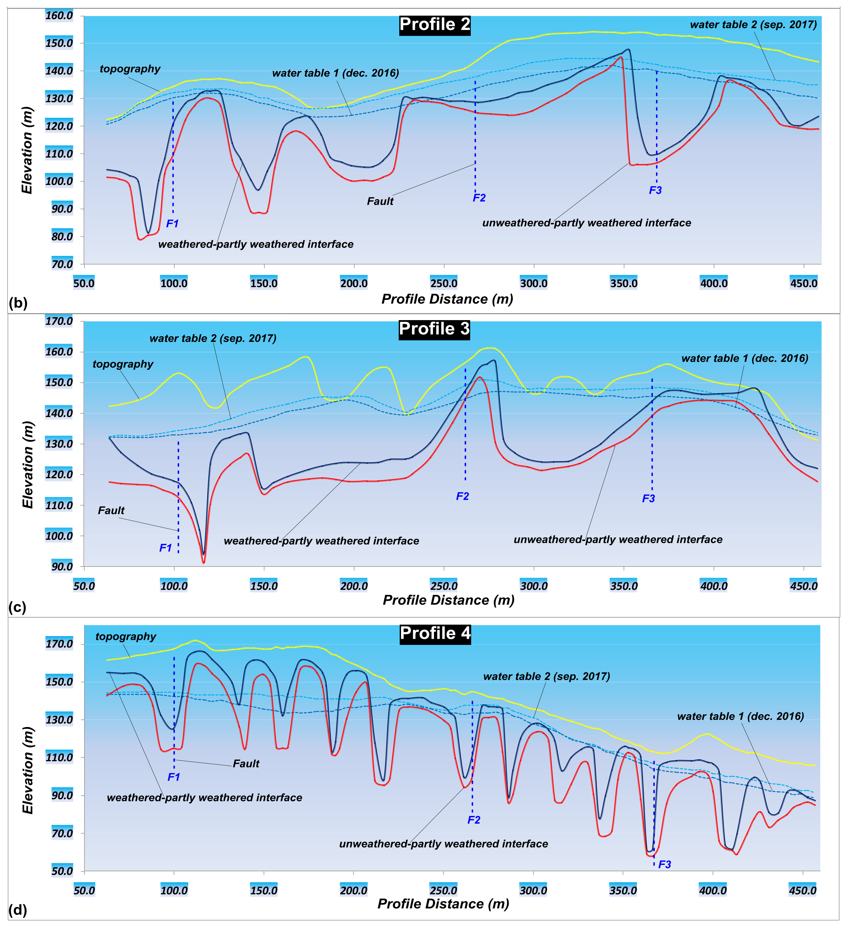
4.2. Profile 2
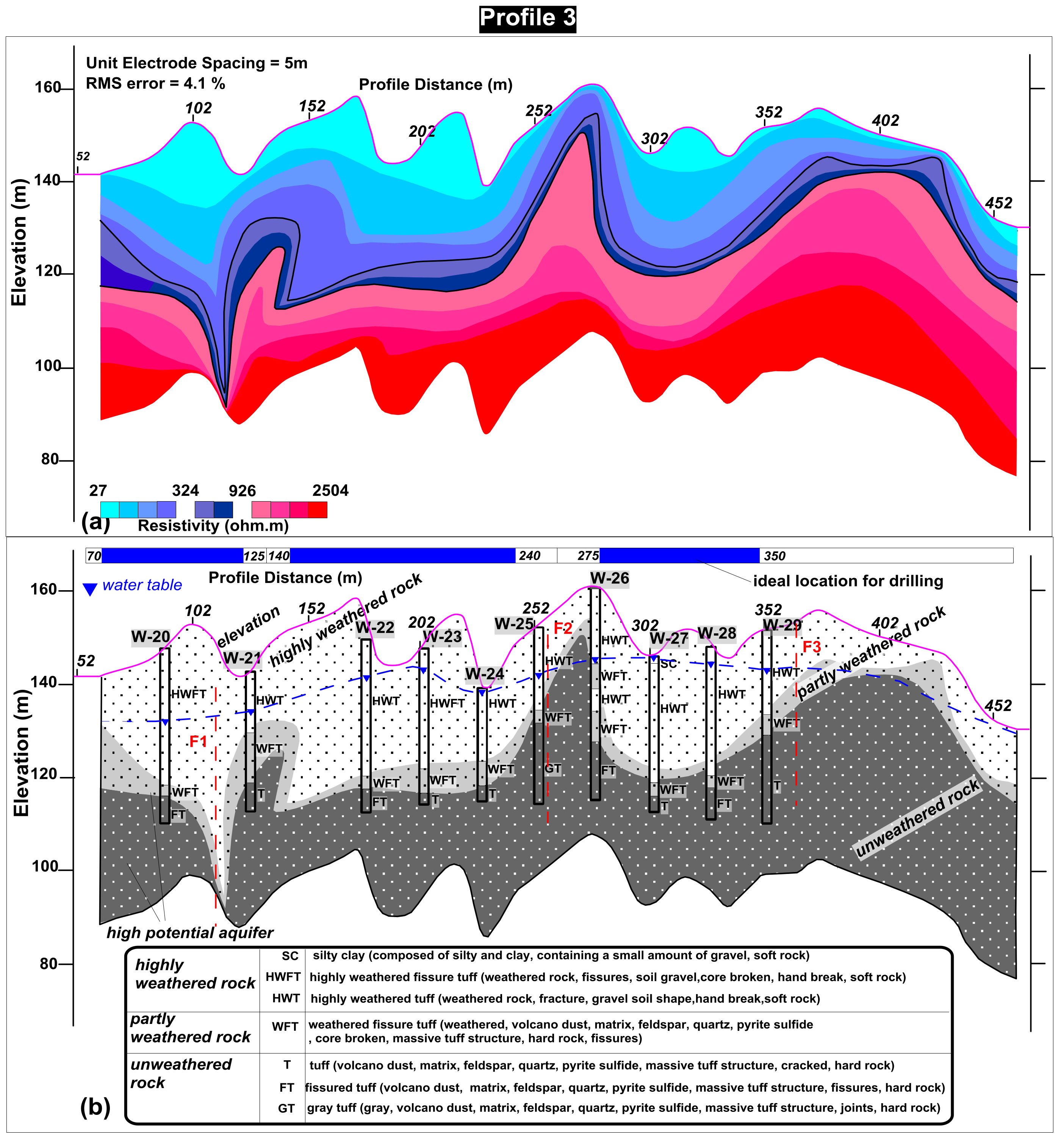
4.3. Profile 3
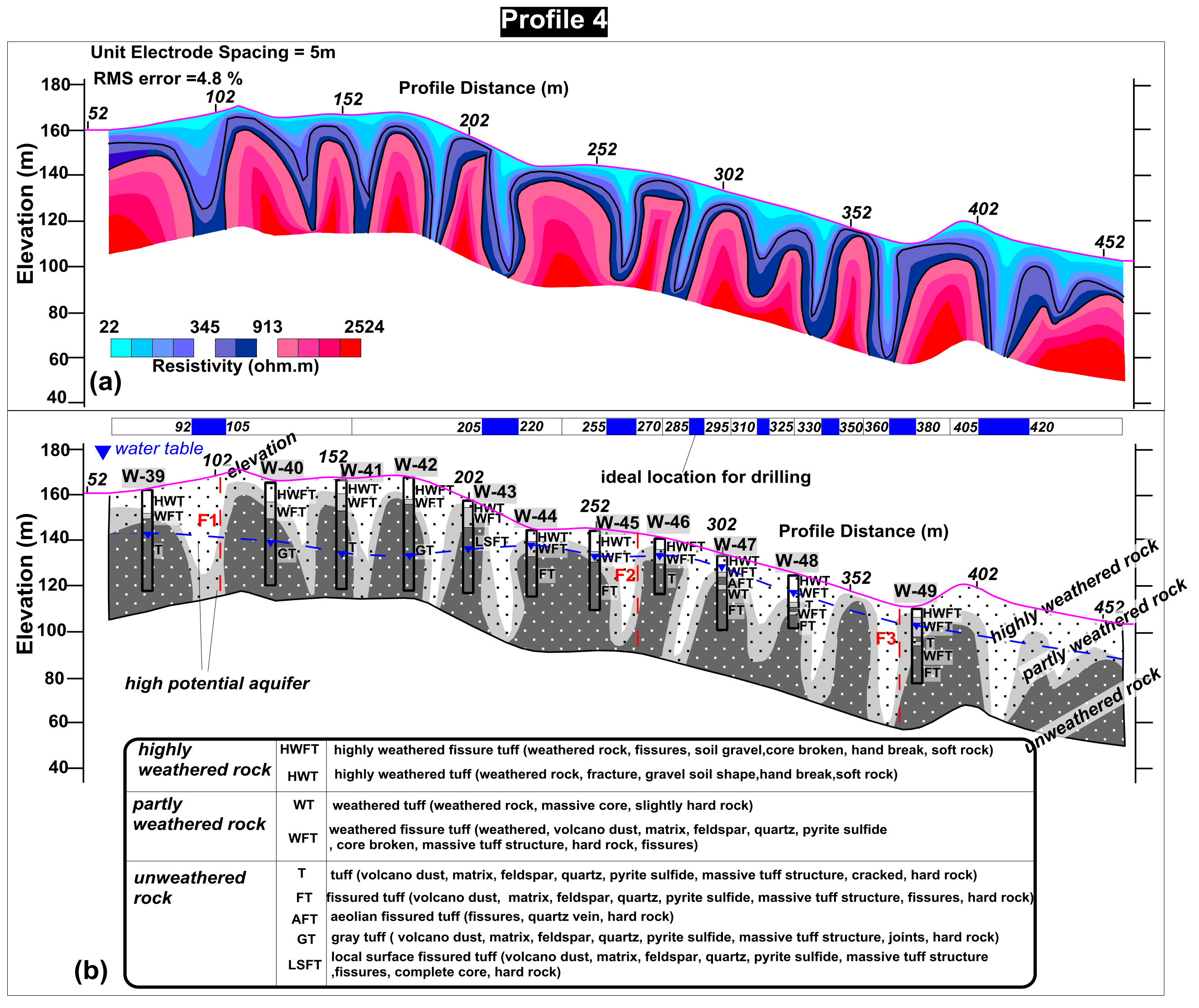
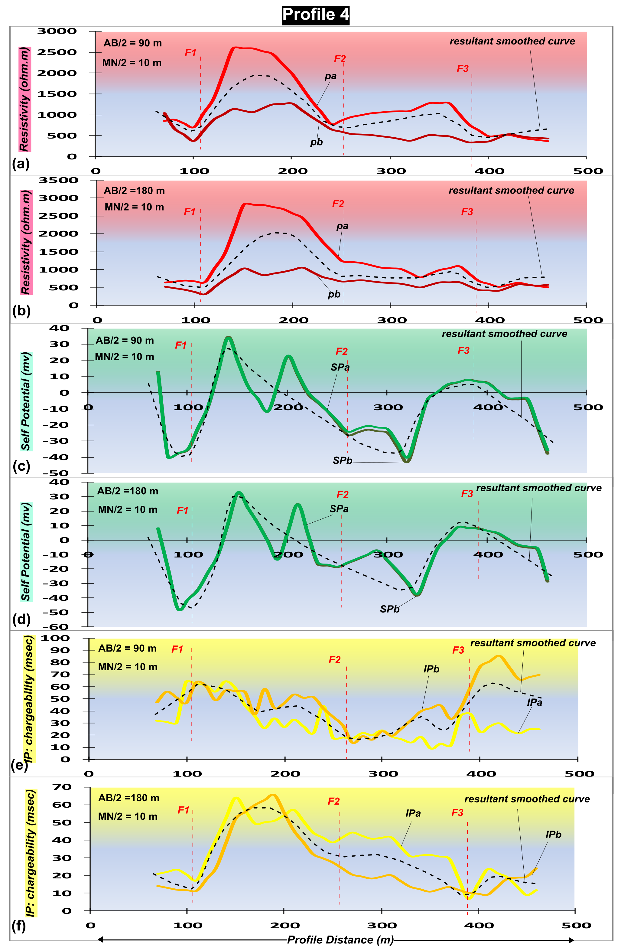
4.4. Profile 4
4.5. Analysis of Rock Samples
4.6. Analysis of Water Samples
5. Discussion
6. Conclusions
Acknowledgments
Author Contributions
Conflicts of Interest
References
- Dahlin, T. The development of electrical imaging techniques. Comput. Geosci. 2001, 27, 1019–1029. [Google Scholar] [CrossRef]
- Pellerin, L. Applications of electrical and electromagnetic methods for environmental and geotechnical investigations. Surv. Geophys. 2002, 23, 101–132. [Google Scholar] [CrossRef]
- Loke, M.H.; Barker, R.D. Rapid least-squares inversion of apparent resistivity pseudosections by a quasi-Newton method. Geophys. Prospect. 1996, 44, 131–152. [Google Scholar] [CrossRef]
- Loke, M.H.; Chambers, J.E.; Rucker, D.F.; Kuras, O.; Wilkinson, P.B. Recent developments in the direct-current geoelectrical imaging method. J. Appl. Geophys. 2013, 95, 135–156. [Google Scholar] [CrossRef]
- Binley, A.; Hubbard, S.S.; Huisman, J.A.; Revil, A.; Robinson, D.A.; Singha, K.; Slater, L.D. The emergence of hydrogeophysics for improved understanding of subsurface processes over multiple scales. Water Resour. Res. 2015, 51, 3837–3866. [Google Scholar] [CrossRef] [PubMed]
- Kemna, A.; Binley, A.; Ramirez, A.; Daily, W. Complex resistivity tomography for environmental applications. Chem. Eng. J. 2000, 77, 11–18. [Google Scholar] [CrossRef]
- Sandberg, S.K.; Slater, L.D.; Versteeg, R. An integrated geophysical investigation of the hydrogeology of an anisotropic unconfined aquifer. J. Hydrol. 2002, 267, 227–243. [Google Scholar] [CrossRef]
- Apparao, A.; Roy, A. Field results for direct current resistivity profiling with two-electrode array. Geoexploration 1973, 11, 21–44. [Google Scholar] [CrossRef]
- Verma, R.; Bandyopadhyay, T. Use of the resistivity methods in geological mapping-case histories from Raniganj Coalfield, India. Geophys. Prospect. 1983, 31, 490–507. [Google Scholar] [CrossRef]
- Batayneh, A.T. Resistivity imaging for near-surface resistive dyke using two-dimensional DC resistivity techniques. J. Appl. Geophys. 2001, 48, 25–32. [Google Scholar] [CrossRef]
- Loke, M.H. Tutorial: 2D and 3D Electrical Imaging Surveys; University of Alberta: Edmonton, AB, Canada, 2004; Available online: https://sites.ualberta.ca/~unsworth/UA-classes/223/loke_course_notes.pdf (accessed on 7 March 2018).
- Loke, M.H. Electrical Imaging Surveys for Environmental and Engineering Studies. A Practical Guide to 2D and 3D Surveys; Pergamon Press Inc.: Oxford, UK, 1966. [Google Scholar]
- Daniels, F.; Alberty, R.A. Physical Chemistry; John Wiley and Sons, Inc.: Hoboken, NJ, USA, 1966. [Google Scholar]
- Telford, W.M.; Geldart, L.P.; Sheriff, R.E. Applied Geophysics, 2nd ed.; Cambridge University Press: Cambridge, UK, 1990. [Google Scholar]
- Dahlin, T. 2D resistivity surveying for environmental and engineering applications. First Break 1996, 14, 275–283. [Google Scholar] [CrossRef]
- Seaton, W.J.; Burbey, T.J. Evaluation of two-dimensional resistivity methods in a fractured crystalline-rock terrain. J. Appl. Geophys. 2002, 51, 21–41. [Google Scholar] [CrossRef]
- Akhter, G.; Hasan, M. Determination of aquifer parameters using geoelectrical sounding and pumping test data in Khanewal District, Pakistan. Open Geosci. 2016, 8, 630–638. [Google Scholar] [CrossRef]
- Hasan, M.; Shang, Y.; Akhter, G.; Khan, M. Geophysical Investigation of Fresh-Saline Water Interface: A Case Study from South Punjab, Pakistan. Groundwater 2017, 55, 841–856. [Google Scholar] [CrossRef] [PubMed]
- Hasan, M.; Shang, Y.; Akhter, G.; Jin, W. Geophysical Assessment of Groundwater Potential: A Case Study from Mian Channu Area, Pakistan. Groundwater 2017. [Google Scholar] [CrossRef] [PubMed]
- Morse, M.; Lu, N.; Godt, J.; Revil, A.; Coe, J. Comparison of Soil Thickness in a Zero-Order Basin in the Oregon Coast Range Using a Soil Probe and Electrical Resistivity Tomography. J. Geotech. Geoenviron. Eng. 2012, 138, 1470–1482. [Google Scholar] [CrossRef]
- Palacky, G.J.; Kadekaru, K. Effect of tropical weathering on electrical and electromagnetic measurements. Geophysics 1979, 44, 69–88. [Google Scholar] [CrossRef]
- Doyle, H.A.; Lindeman, F.W. The effect of deep weathering on geophysical exploration in Australia—A review. Aust. J. Earth Sci. 1985, 32, 125–135. [Google Scholar] [CrossRef]
- Timms, W.; Acworth, I. Origin, lithology and weathering characteristics of Upper Tertiary—Quaternary clay aquitard units on the Lower Murrumbidgee alluvial fan. Aust. J. Earth Sci. 2002, 49, 525–537. [Google Scholar] [CrossRef]
- Kellett, R.; Bauman, P. Mapping groundwater in regolith and fractured bedrock using ground geophysics: A case study from Malawi, SE Africa. Recorder 2004, 29, 24–32. [Google Scholar]
- Barongo, J.O.; Palacky, G.J. Investigations of electrical properties of weathered layers in the Yala Area, Western Kenya, using resistivity soundings. Geophysics 1991, 56, 133–138. [Google Scholar] [CrossRef]
- Ritz, M.; Parisot, J.C.; Diouf, S.; Beauvais, A.; Dione, F.; Niang, M. Electrical imaging of lateritic weathering mantles over granitic and metamorphic basement of eastern Senegal, West Africa. J. Appl. Geophys. 1999, 41, 335–344. [Google Scholar] [CrossRef]
- Revil, A.; Hermitte, D.; Spangenberg, E.; Cochémé, J.J. Electrical properties of zeolitized volcaniclastic materials. J. Geophys. Res. 2002, 107, 2168. [Google Scholar] [CrossRef]
- Jardani, A.; Revil, A.; Barrash, W.A.; Crespy, E.; Rizzo, S.; Straface, M.; Cardiff, B.; Malama, C.; Miller, C.; Johnson, T. Reconstruction of the water table from self potential data: A Bayesian approach. Groundwater 2009, 47, 213–227. [Google Scholar] [CrossRef] [PubMed]
- Jardani, A.; Revil, A.; Santos, F.; Fauchard, C.; Dupont, J.P. Detection of preferential infiltration pathways in sinkholes using joint inversion of self-potential and EM-34 conductivity data. Geophys. Prospect. 2007, 55, 1–11. [Google Scholar] [CrossRef]
- Revil, A.; Murugesu, M.; Prasad, M.; Le Breton, M. Alteration of volcanic rocks: A new non-intrusive indicator based on induced polarization measurements. J. Volcanol. Geotherm. Res. 2017, 341, 351–362. [Google Scholar] [CrossRef]
- Johnson, T.C.; Versteeg, R.J.; Ward, A.F.; Day-Lewis, D.; Revil, A. Improved hydrogeophysical characterization and monitoring through high performance electrical geophysical modeling and inversion. Geophysics 2010, 75, WA27–WA41. [Google Scholar] [CrossRef]
- Schulz, R. Interpretation and depth of investigation of gradient measurements in direct current geoelectrics. Geophys. Prospect. 1985, 33, 1240–1253. [Google Scholar] [CrossRef]
- Shettigara, V.K.; Adams, W.M. Detection of lateral variations in geological structures using electrical-resistivity gradient profiling. Geophys. Prospect. 1989, 37, 293–310. [Google Scholar] [CrossRef]
- Furness, P. Gradient array profiles over thin resistive veins. Geophys. Prospect. 1993, 41, 113–130. [Google Scholar] [CrossRef]
- Kumar, D.; Anand, V.; Rao, V.A.; Sharma, V.S. Hydrogeological and geophysical study for deeper groundwater resource in quartzitic hard rock ridge region from 2D resistivity data. J. Earth Syst. Sci. 2014, 123, 531–543. [Google Scholar] [CrossRef]
- Szalai, S.; Novak, A.; Szarka, L. Which geoeletric array sees the deepest in a noisy environment? Depth of detectability values of multielectrode systems for various two dimensional models. Phys. Chem. Earth 2011, 36, 1398–1404. [Google Scholar] [CrossRef]
- Dahlin, T.; Zhou, B. A numerical comparison of 2D resistivity imaging with 10 electrode arrays. Geophys. Prospect. 2004, 52, 379–398. [Google Scholar] [CrossRef]
- Pous, J.; Queralt, P.; Chavez, R. Lateral and topographical effects in geoelectric soundings. J. Appl. Geophys. 1996, 35, 237–248. [Google Scholar] [CrossRef]
- Tsourlos, P.; Szymansky, J.; Tsokas, G. The effect of terrain topography on commonly used resistivity arrays. Geophysics 1999, 64, 1357–1363. [Google Scholar] [CrossRef]
- Bureau of Geology and Mineral Resources of Guangdong Province (Guangdong, B.G.M.R.). Regional Geology of Guangdong Province; Geology Publishing House: Beijing, China, 1988; pp. 1–602. (In Chinese)
- Mendoza, J.A. Geophysical and Hydrogeological Investigations in the Rio Sucio Watershed, Nicaragua; Lund University: Lund, Sweden, 2002; ISBN 919724060X. [Google Scholar]
- Griffiths, D.H.; Barker, R.D. Two-dimensional resistivity imaging and modeling in areas of complex geology. J. Appl. Geophys. 1993, 29, 211–226. [Google Scholar] [CrossRef]
- Kumar, D. Efficacy of electrical resistivity tomography technique in mapping shallow subsurface anomaly. J. Geol. Soc. India 2012, 80, 304–307. [Google Scholar] [CrossRef]
- Loke, M.H.; Barker, R.D. Leastsquares deconvolution of apparent resistivity pseudosections. Geophysics 1995, 60, 1682–1690. [Google Scholar] [CrossRef]
- Loke, M.H. RES2DINV Software User’s Manual, Version 3.57; Geotomo Software: Penang, Malysia, 2007; p. 86. [Google Scholar]
- De Groot-Hedlin, C.; Constable, S.C. Occam’s inversion to generate smooth, two-dimensional models from magnetotelluric data. Geophysics 1990, 55, 1613–1624. [Google Scholar] [CrossRef]
- Ellis, R.G.; Oldenburg, D.W. Applied geophysical inversion. Geophys. J. Int. 1994, 116, 5–11. [Google Scholar] [CrossRef]
- Edwards, L.S. A modified pseudosection for resistivity and induced-polarization. Geophysics 1977, 42, 1020–1036. [Google Scholar] [CrossRef]
- Lines, L.R.; Treitel, S. Tutorial: A review of the least-squares inversion and its application to geophysical problems. Geophys. Prospect. 1984, 32, 159–186. [Google Scholar] [CrossRef]
- Sasaki, Y. Resolution of the resistivity tomography inferred from numerical simulation. Geophys. Prospect. 1992, 40, 453–464. [Google Scholar] [CrossRef]
- Golub, G.H.; Van Loan, C.F. Matrix Computations; Johns Hopkins University Press: Baltimore, MD, USA, 1989. [Google Scholar]
- American Board of Emergency Medicine (ABEM). Terrameter SAS4000/SAS1000 LUND Imaging System, Instruction Manual; ABEM Instrument AB: Sundbyberg, Sweden, 2006. [Google Scholar]
- Wyns, R.; Gourry, J.C.; Baltassat, J.M.; Lebert, F. Multiparameter characterization of subsurface horizons (0–100 m) in an altered basement context. In Proceedings of the 2nd GEOFCAN Symposium, Orleans, France, 21–22 September 1999; pp. 105–110. [Google Scholar]
- Jones, M.J. The Weathered Zones Aquifers o Basement Complex Area of African. Q. J. Eng. Geol. Lond. 1985, 18, 35–45. [Google Scholar] [CrossRef]
- American Public Health Association (APHA); American Water Works Association (AWWA); Water Environment Federation (WEF). Standard Methods for theExaminations of Water and Wastewaters, 19th ed.; American Public Health Association: Washington, DC, USA, 1995; Volume 4. [Google Scholar]
- Radojevic, M.; Bashkin, V.N. Practical Environmental Analysis; Royal Society of Chemistry: Cambridge, UK, 1999. [Google Scholar]
- Hasan, M.; Shang, Y.; Akhter, G.; Jin, W. Evaluation of Groundwater Suitability for Drinking and Irrigation Purposes in Toba Tek SinghDistrict, Pakistan. Irrig. Drain. Syst. Eng. 2017, 6, 185. [Google Scholar] [CrossRef]
- World Health Organization (WHO). Recommendations Incorporating 1st and 2nd Addenda. In Guidelines for Drinking-Water Quality, 3rd ed.; World Health Organization: Geneva, Switzerland, 2008; Volume 1. [Google Scholar]


| Resistivity of Rock (Ωm) | Type of Rock |
|---|---|
| Below water table and the resistivity between 22 Ωm–345 Ωm | Highly weathered rock |
| Below water table and resistivity between 324 Ωm–926 Ωm | Partly weathered rock |
| Below water table and resistivity greater between 913 Ωm–2579 Ωm | Unweathered rock |
| Rock Sample Number | Description | Major Minerals (>50%) | Secondary Minerals (10–30%) | Minor Minerals (5–10%) |
|---|---|---|---|---|
| 1 (Weathered rock) | Red weathered soil | Quartz | - | Halloysite |
| 2 (Weathered rock) | Yellow weathered soil | Quartz | - | - |
| 3 (Weathered rock) | Earthy fault mud | Quartz | Microcline | Perlite |
| 4 (Weathered rock) | Brown yellow residual soil | Quartz | Kaolinite | - |
| 5 (Bedrock) | Gray black tuff | Quartz | Albite, Zinnwaldite | Sodalite |
| 6 (Bedrock) | Gray black tuff | Quartz | Albite, Zinnwaldite | Ankerite |
| Water Sample Number | Parameters | |||||||||||||
| Cations (Measured Concentration in mg/L) | Anions (Measured Concentration in mg/L) | EC (μS/cm) | TDS (mg/L) | pH | Charge Balance Error (%) | |||||||||
| Na+ | K+ | Ca2+ | Mg2+ | NH4+ | Cl− | SO42− | HCO3− | NO3− | ||||||
| 1 | 10.6 | 3.84 | 4.06 | 0.74 | 0.02 | 8.54 | 1.19 | 38.89 | 0.28 | 125 | 68.76 | 7.68 | −4.9 | |
| 2 | 9.8 | 3.07 | 1.62 | 0.49 | 0.02 | 8.54 | 1.81 | 23.93 | 0.16 | 113 | 61.09 | 7.58 | −3.7 | |
| 3 | 13 | 3.11 | 2.84 | 0.49 | 0.02 | 10.68 | 0.94 | 29.91 | 0.10 | 127 | 69.59 | 7.02 | 0.9 | |
| 4 | 11.4 | 3.24 | 2.84 | 1.23 | 0.02 | 9.61 | 1.19 | 35.89 | 0.22 | 140 | 76.30 | 7.28 | −3.7 | |
| 5 | 9.9 | 3.70 | 4.87 | 1.48 | 0.02 | 10.68 | 3.89 | 35.89 | 0.31 | 137 | 74.67 | 7.11 | −4.5 | |
| 6 | 9.5 | 3.68 | 4.74 | 1.45 | 0.02 | 10.88 | 3.23 | 34.23 | 0.32 | 135 | 73.20 | 7.13 | −4.2 | |
| WHO limit for groundwater parameters | ||||||||||||||
| 200 | 55 | 100 | 50 | - | 250 | 200 | 600 | - | 1500 | 1000 | 6.5–8.5 | |||
| Samples exceeding WHO limit [58] | ||||||||||||||
| - | - | - | - | - | - | - | - | - | - | - | - | |||
© 2018 by the authors. Licensee MDPI, Basel, Switzerland. This article is an open access article distributed under the terms and conditions of the Creative Commons Attribution (CC BY) license (http://creativecommons.org/licenses/by/4.0/).
Share and Cite
Gao, Q.; Shang, Y.; Hasan, M.; Jin, W.; Yang, P. Evaluation of a Weathered Rock Aquifer Using ERT Method in South Guangdong, China. Water 2018, 10, 293. https://doi.org/10.3390/w10030293
Gao Q, Shang Y, Hasan M, Jin W, Yang P. Evaluation of a Weathered Rock Aquifer Using ERT Method in South Guangdong, China. Water. 2018; 10(3):293. https://doi.org/10.3390/w10030293
Chicago/Turabian StyleGao, Qiang, Yanjun Shang, Muhammad Hasan, Weijun Jin, and Peng Yang. 2018. "Evaluation of a Weathered Rock Aquifer Using ERT Method in South Guangdong, China" Water 10, no. 3: 293. https://doi.org/10.3390/w10030293
APA StyleGao, Q., Shang, Y., Hasan, M., Jin, W., & Yang, P. (2018). Evaluation of a Weathered Rock Aquifer Using ERT Method in South Guangdong, China. Water, 10(3), 293. https://doi.org/10.3390/w10030293