Continuously Tracking the Annual Changes of the Hengsha and Changxing Islands at the Yangtze River Estuary from 1987 to 2016 Using Landsat Imagery


Abstract

1. Introduction
2. Study Area and Data
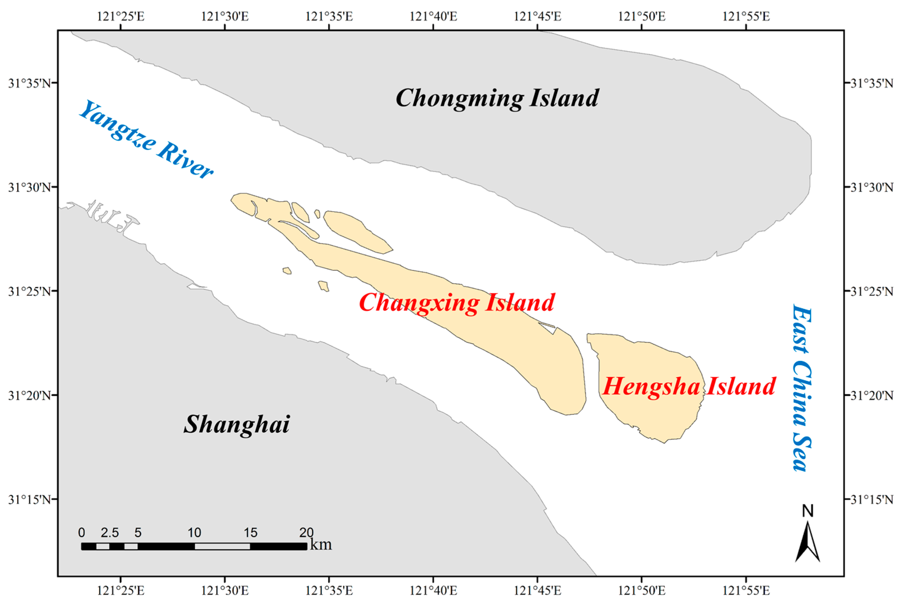
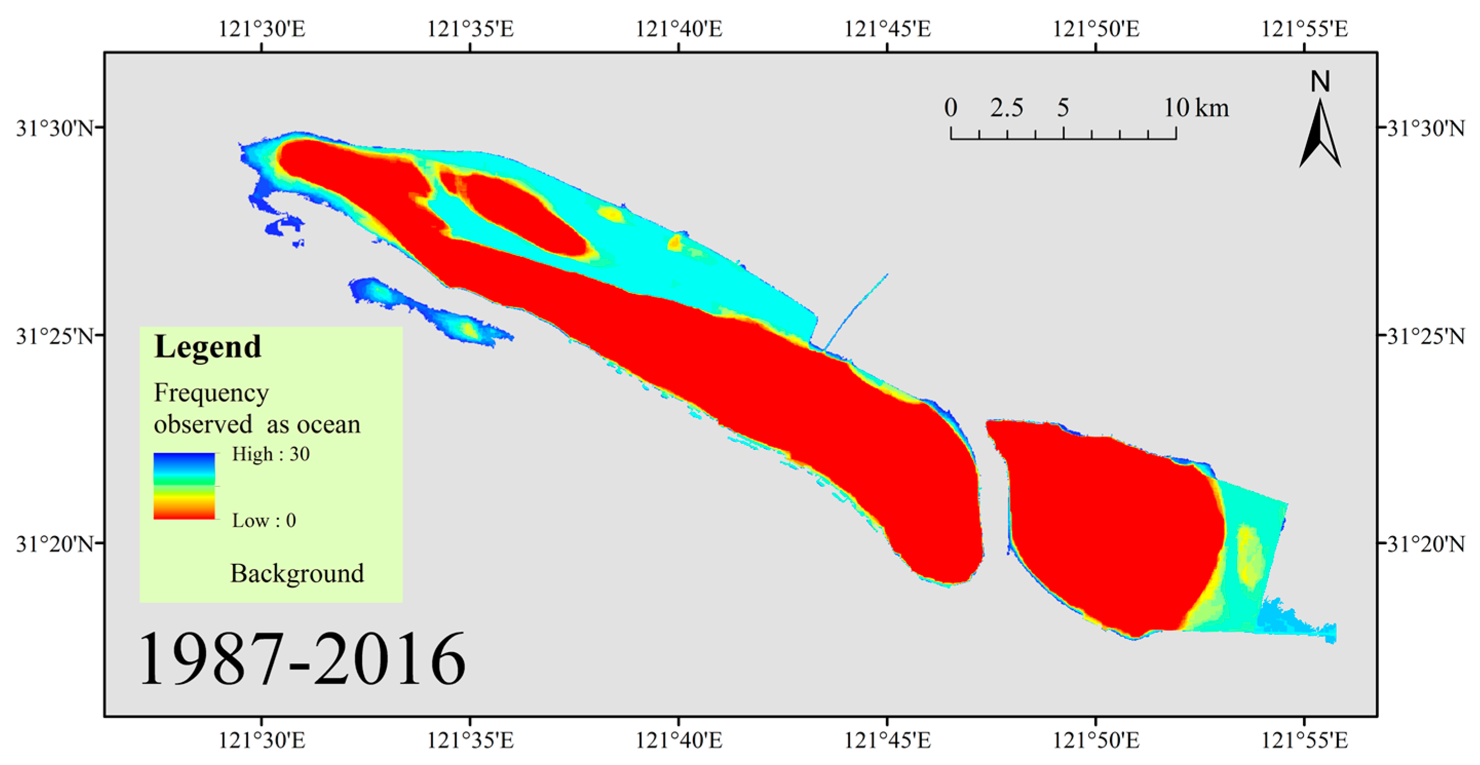
2.1. Study Area
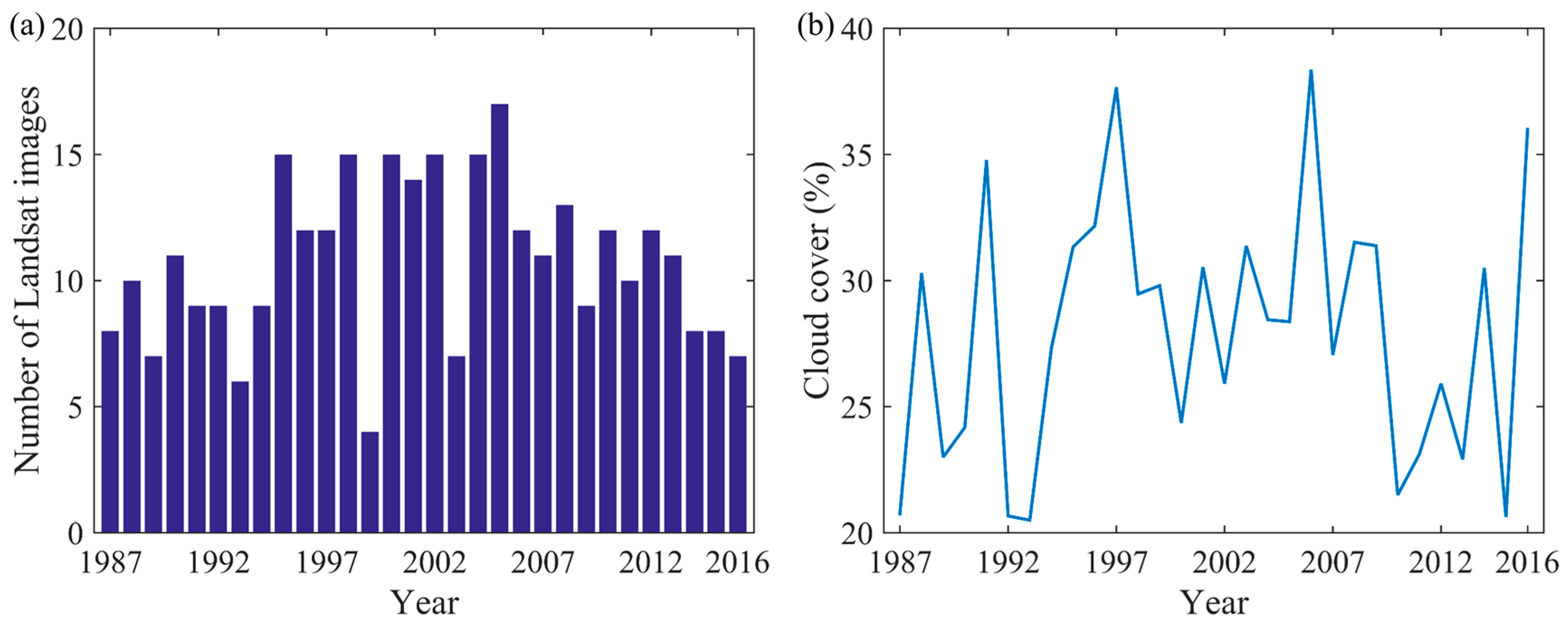
2.2. Data
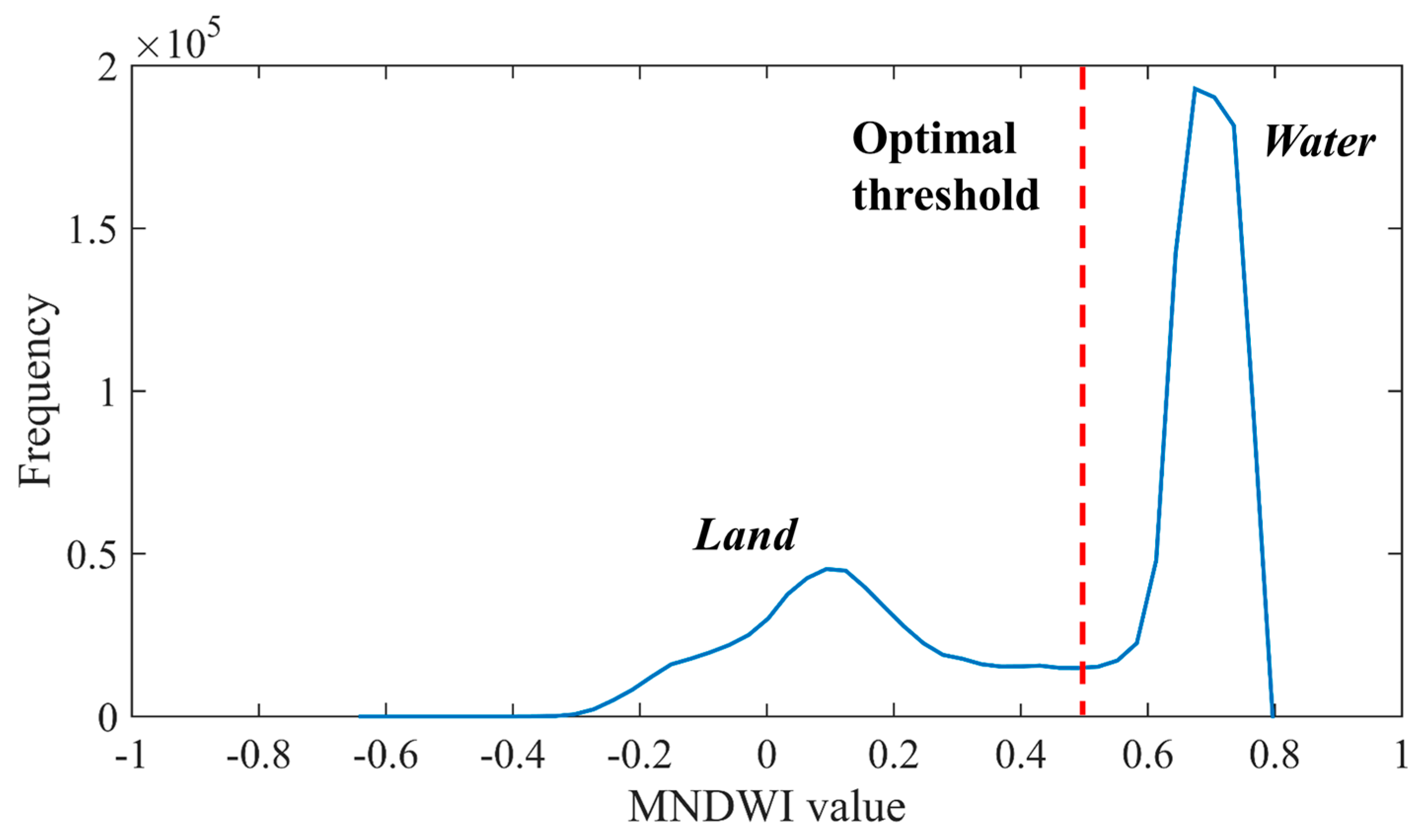
3. Methods
4. Results
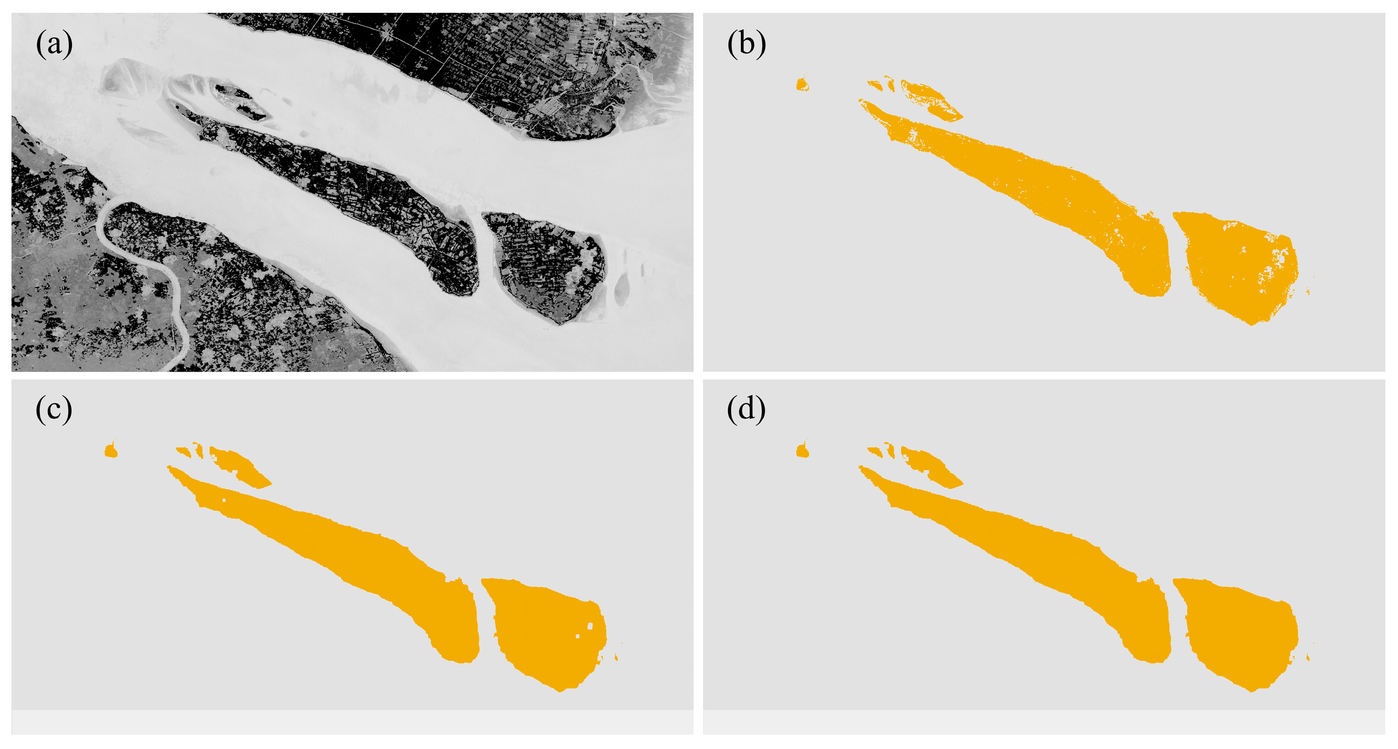
4.1. Estuarine Island Area Extraction
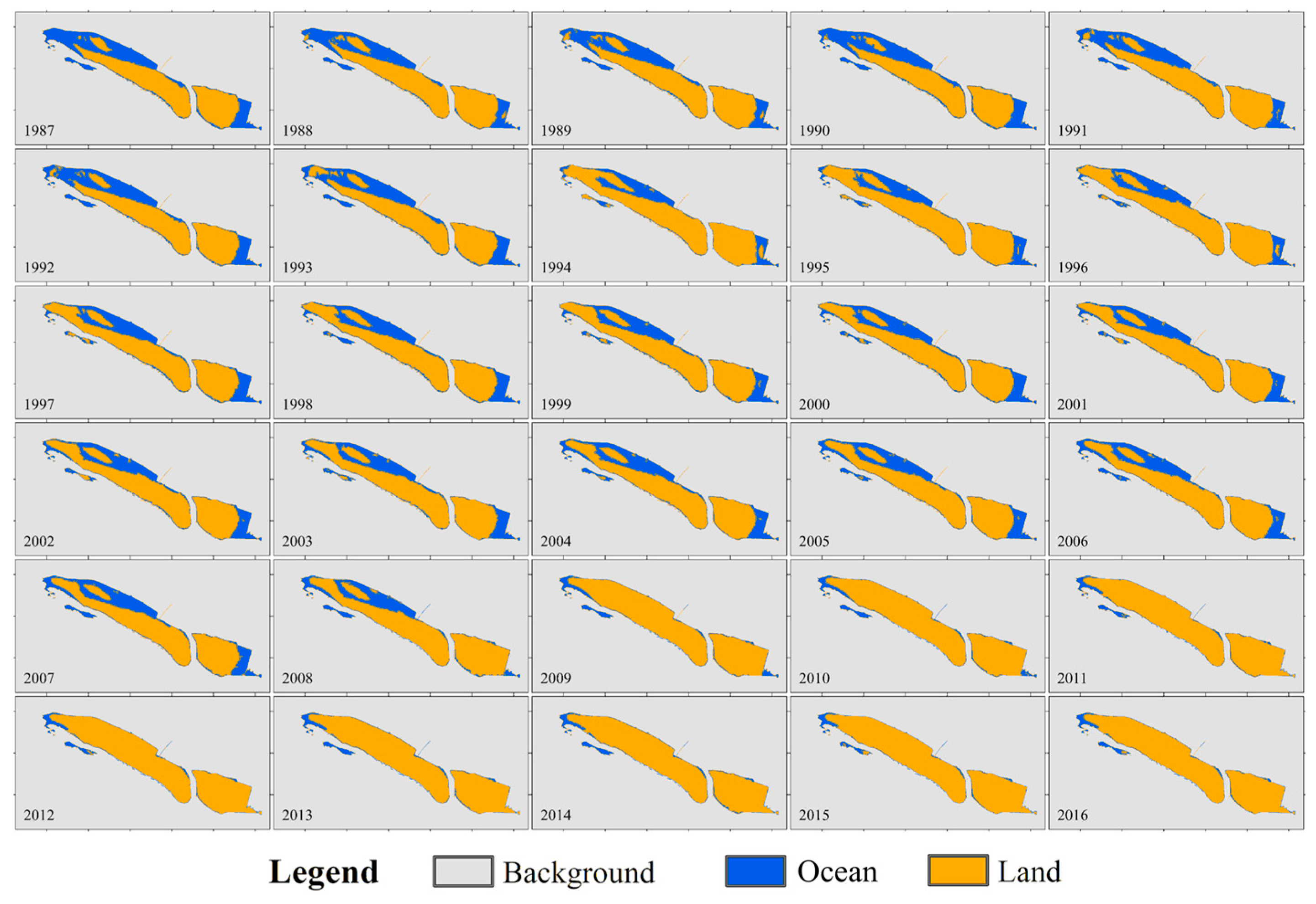
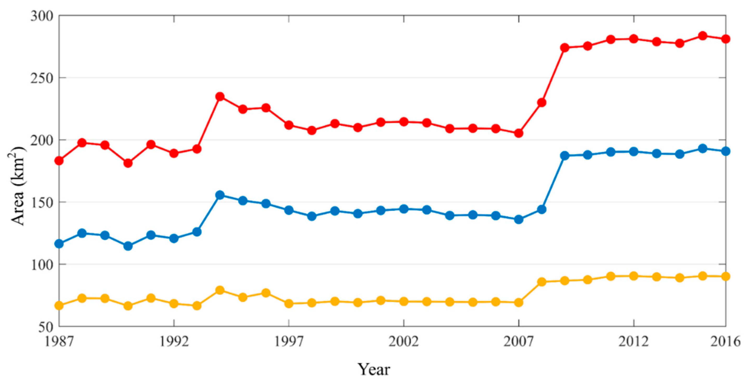
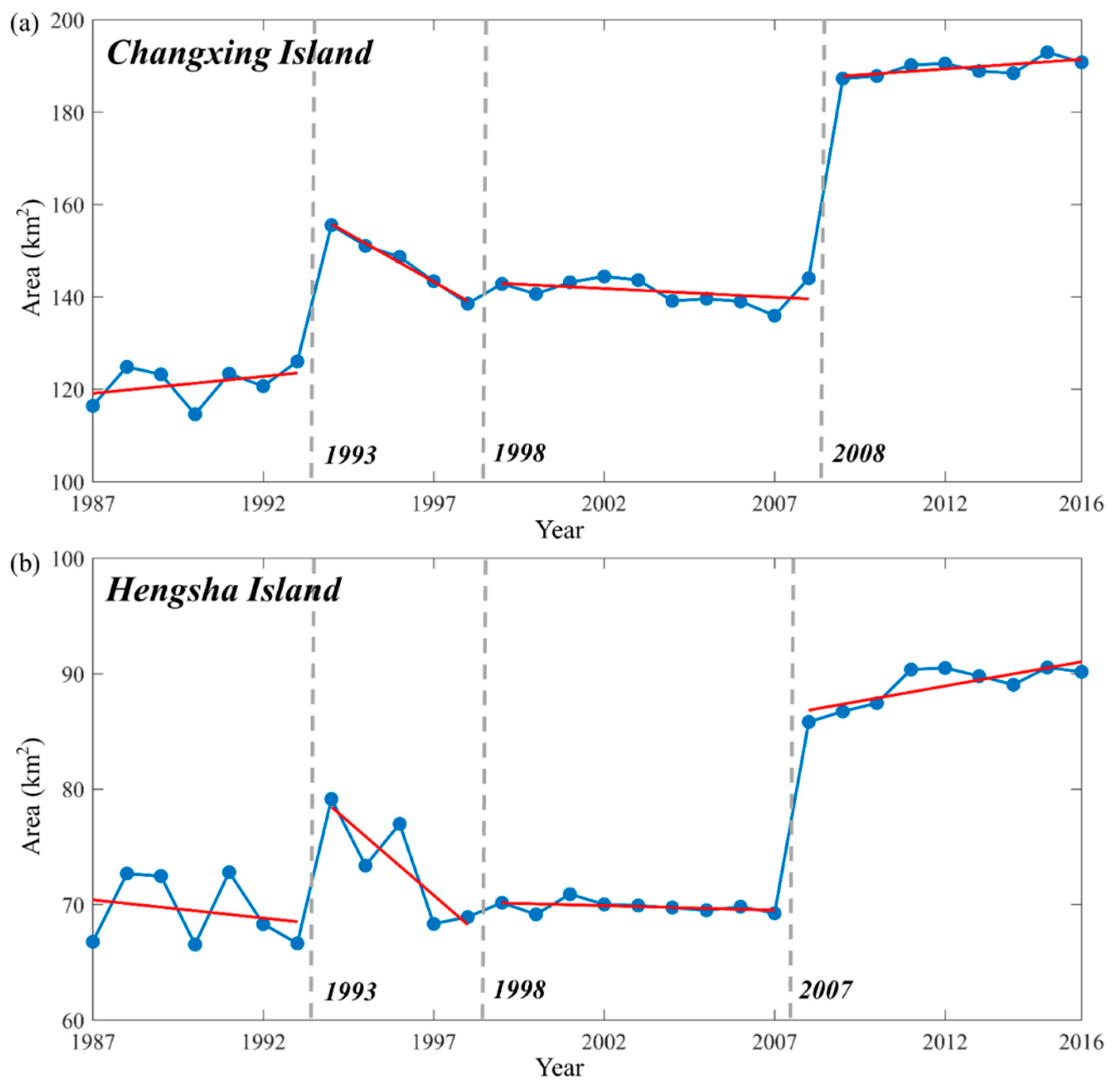
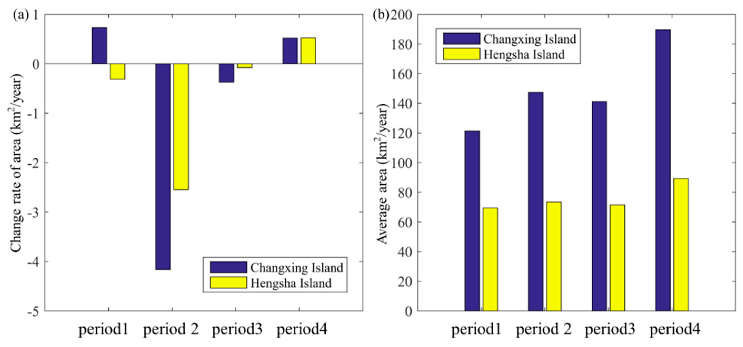
4.2. Coastal Island Area Temporal Change
4.3. Influencing Factors Analysis
5. Discussions
5.1. Comparison of Results from Landsat TM/ETM+ Data
5.2. Influencing Factors of Estuarine Islands Change
5.3. Further Considerations
6. Conclusions
- The time series of Landsat (TM and ETM+) imagery can be used for mapping estuarine islands and tracking their temporal changes on an annual scale. The mapping results derived from the TM data and ETM+ data are in good agreement, which supports the stability of the method. These data and the described method can also be used to continuously track the temporal change of other ground features (e.g., the river, lake, and coastline features).
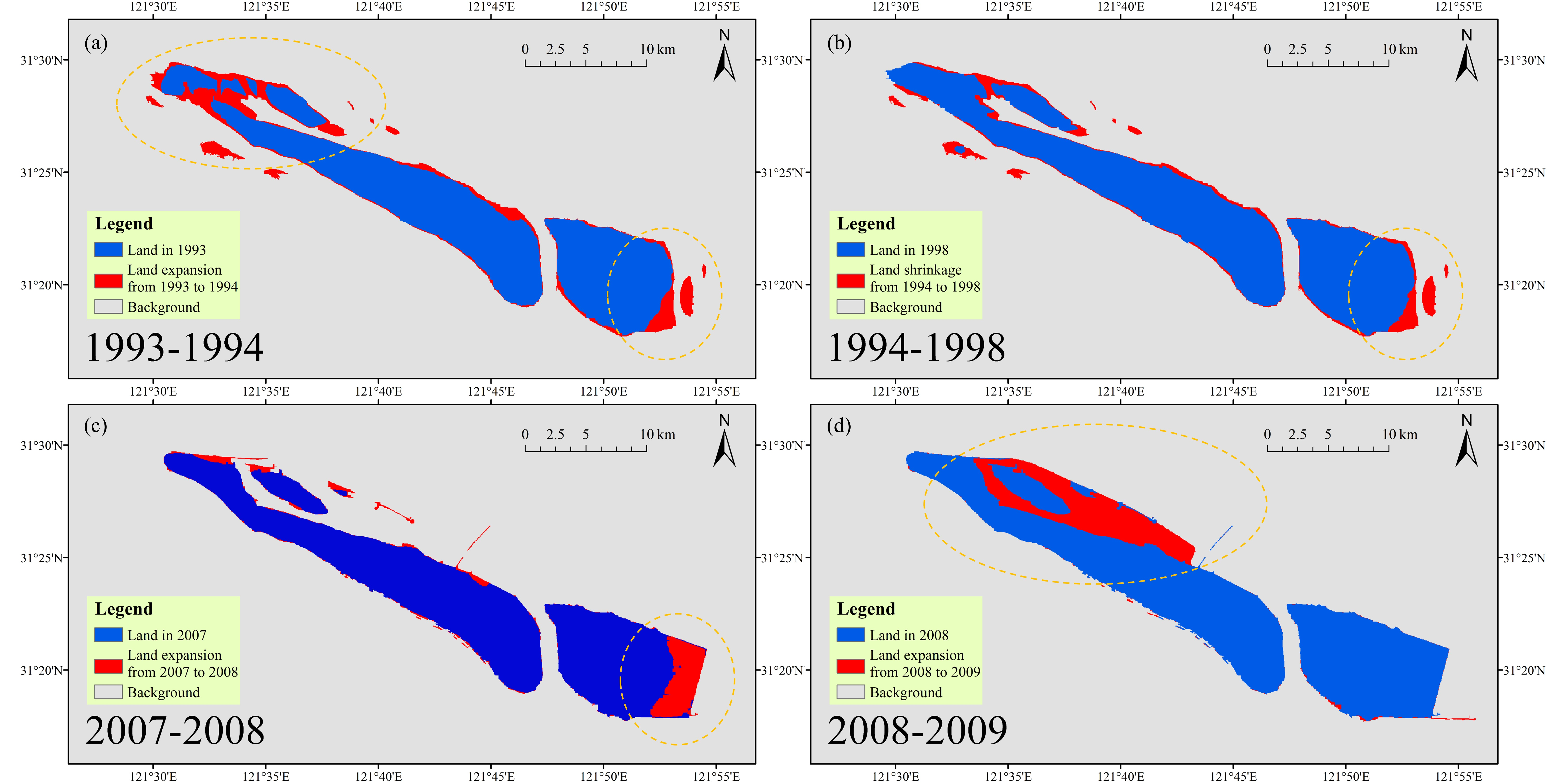
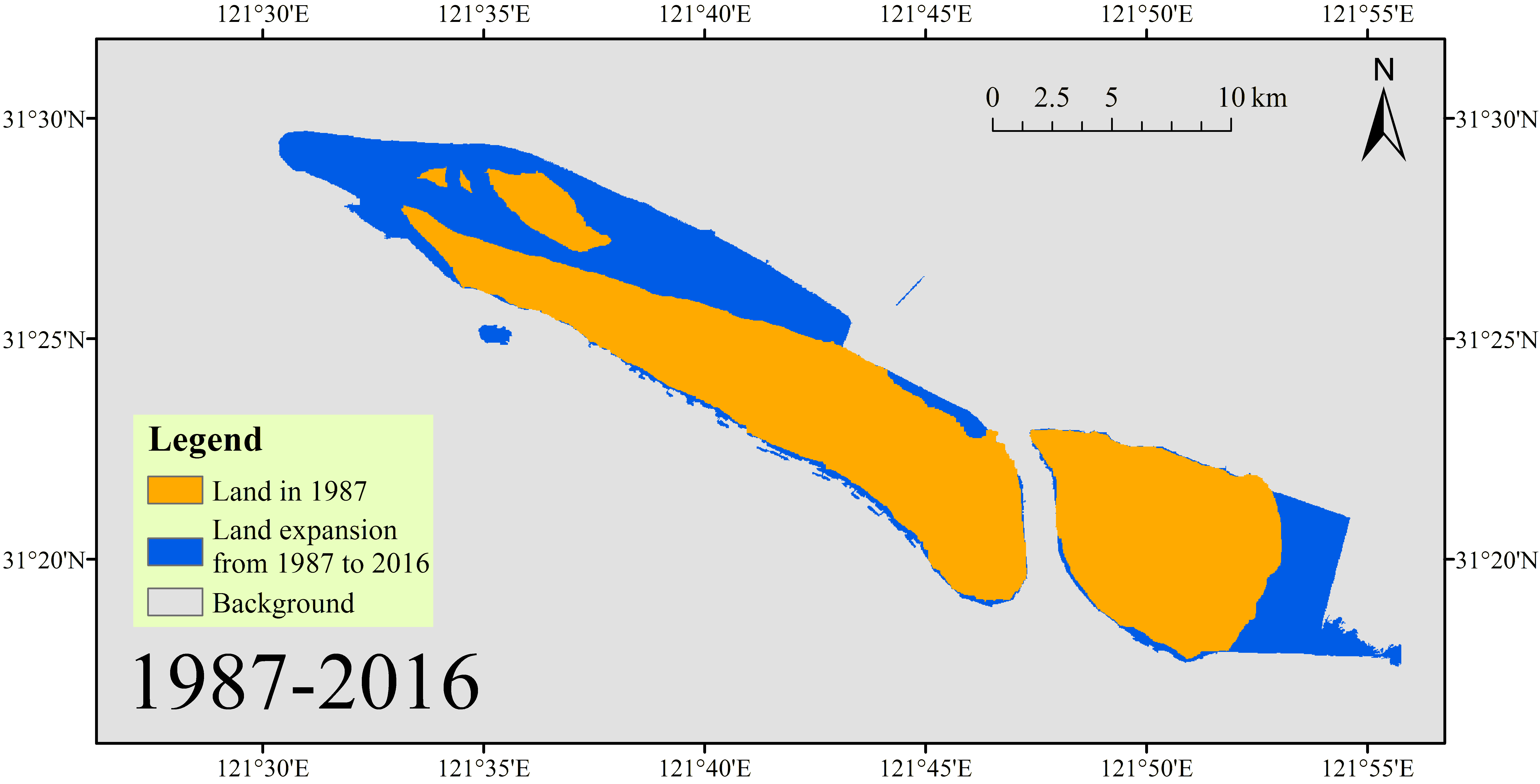
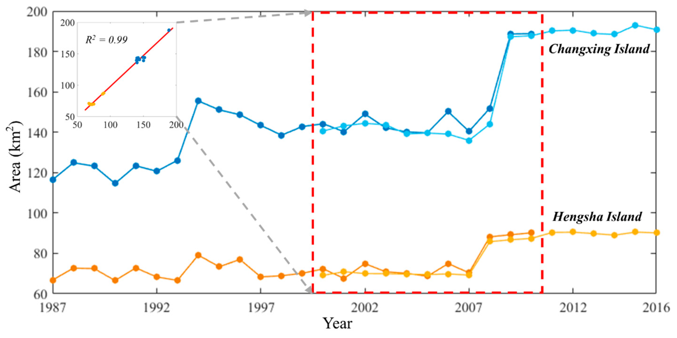
- The two estuarine islands in Shanghai experienced a net increase of their land area from 183.2 km2 to 280.9 km2 with a change rate of 3.3 km2 per year during the period of 1987–2016, and they also exhibited a certain consistency in their temporal variations. During the sub-period from 1993 to 1998, both Changxing Island and Hengsha Island exhibited a significant land shrinkage according the Landsat observations.
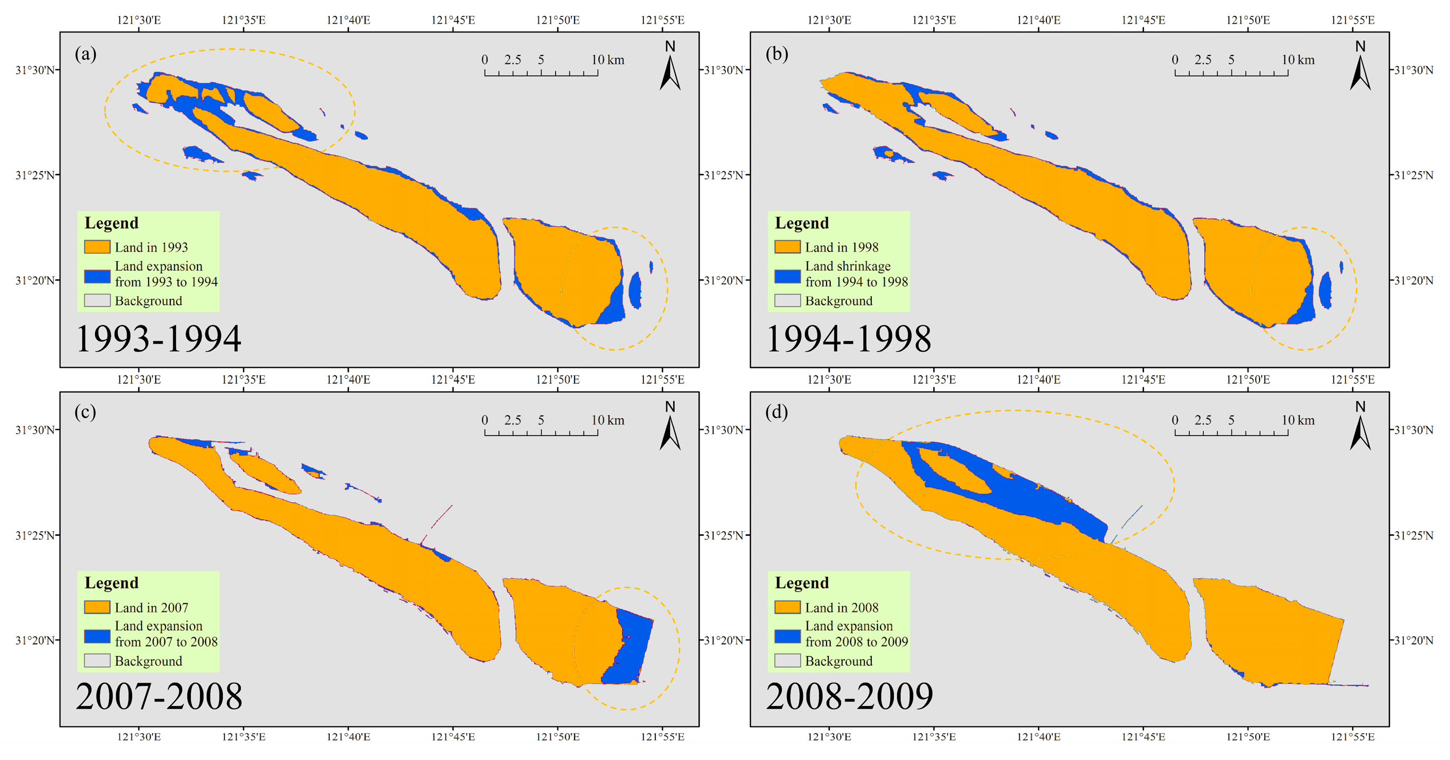
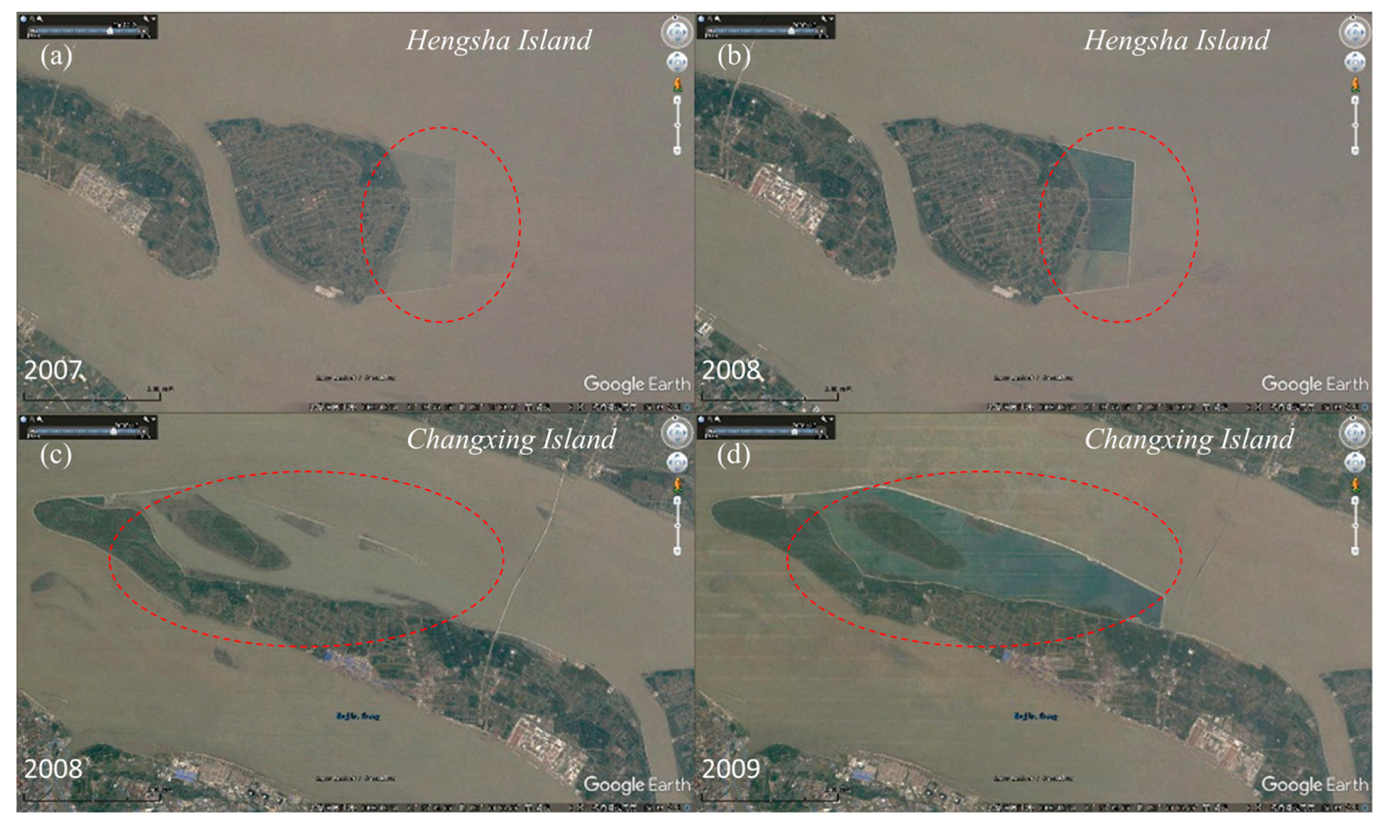
- Sharp increases in land area were observed in 2007 and 2008 for Hengsha Island and Changxing Island, respectively. According to the high-resolution images from Google Earth, human activity (i.e., the Hengsha east shoal reclamation projects and the Qingcaosha Reservoir project) plays an essential role in the rapid expansion of the estuarine islands. Compared with Landsat images, high-resolution images can provide more details from a spatial perspective.
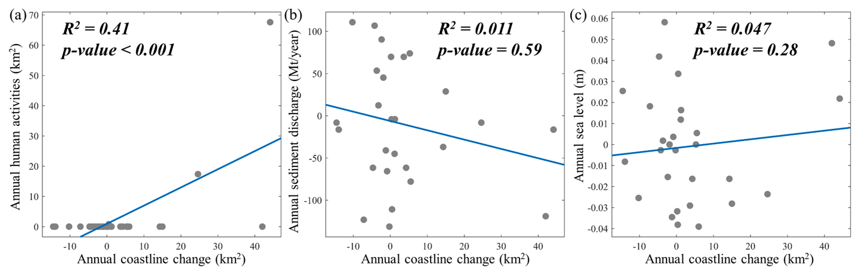
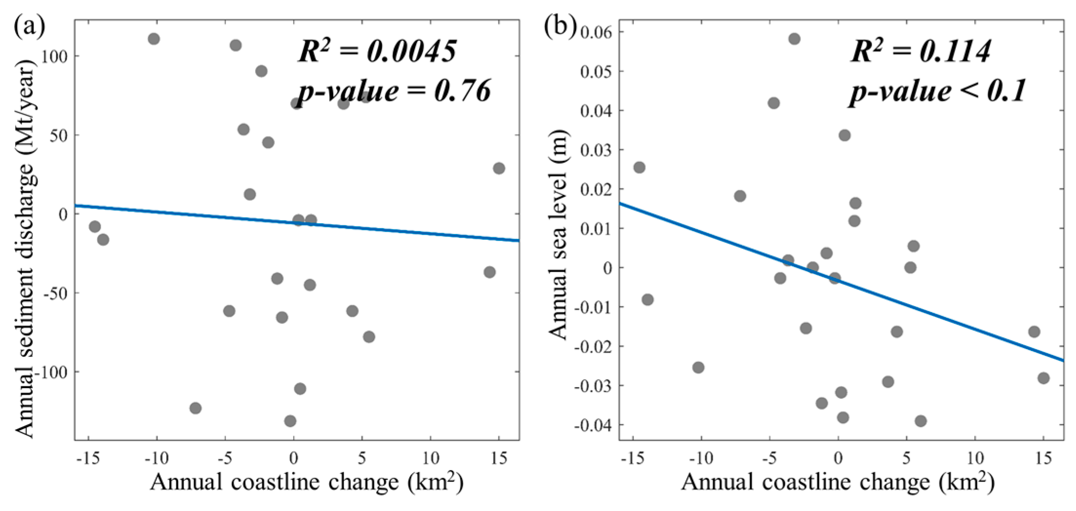
- From 1987 to 2016, human activity was the most important driving factor in the temporal change of estuarine islands on an annual scale (R2 = 0.41, p-value < 0.001). Human activities in Changxing Island and Hengsha Island resulted in a great land expansion of 85.72 km2, accounting for 87.73% of the total land expansion of 97.71 km2. Sea level can also partly explain the change of estuarine islands (R2 = 0.114, p-value < 0.01). Meanwhile, sediment discharge is not a significant driving factor in the estuarine islands’ change (R2 = 0.045, p-value = 0.76).
Acknowledgments
Author Contributions
Conflicts of Interest
References
- Yang, S.L.; Milliman, J.D.; Li, P.; Xu, K. 50,000 dams later: Erosion of the Yangtze River and its delta. Glob. Planet. Chang. 2011, 75, 14–20. [Google Scholar] [CrossRef]
- Chen, X.; Zong, Y. Coastal erosion along the Changjiang deltaic shoreline, China: History and prospective. Estuar. Coast. Shelf Sci. 1998, 46, 733–742. [Google Scholar] [CrossRef]
- Ruan, W.; Gong, H.; Lou, F. Discussion on the new space of strategic development and function of Hengsha, Shanghai. Eng. Sci. 2014, 12, 52–58. [Google Scholar]
- Huang, B.; Ouyang, Z.; Zheng, H.; Zhang, H.; Wang, X. Construction of an eco-island: A case study of Chongming Island, China. Ocean Coast. Manag. 2008, 51, 575–588. [Google Scholar] [CrossRef]
- Gao, A.; Yang, S.L.; Li, G.; Li, P.; Chen, S.L. Long-term morphological evolution of a tidal island as affected by natural factors and human activities, the Yangtze Estuary. J. Coast. Res. 2010, 26, 123–131. [Google Scholar] [CrossRef]
- Tian, B.; Wu, W.; Yang, Z.; Zhou, Y. Drivers, trends, and potential impacts of long-term coastal reclamation in China from 1985 to 2010. Estuar. Coast. Shelf Sci. 2016, 170, 83–90. [Google Scholar] [CrossRef]
- Ma, Z.; Melville, D.S.; Liu, J.; Chen, Y.; Yang, H.; Ren, W.; Zhang, Z.; Piersma, T.; Li, B. Rethinking China’s new great wall. Science 2014, 346, 912–914. [Google Scholar] [CrossRef] [PubMed]
- Cao, W.; Wong, M.H. Current status of coastal zone issues and management in China: A review. Environ. Int. 2007, 33, 985–992. [Google Scholar] [CrossRef] [PubMed]
- Murray, N.J.; Clemens, R.S.; Phinn, S.R.; Possingham, H.P.; Fuller, R.A. Tracking the rapid loss of tidal wetlands in the yellow sea. Front. Ecol. Environ. 2014, 12, 267–272. [Google Scholar] [CrossRef]
- Zhang, C.; Zheng, J.; Dong, X.; Cao, K.; Zhang, J. Morphodynamic response of Xiaomiaohong tidal channel to a coastal reclamation project in Jiangsu Coast, China. International Coastal Symposium (Plymouth, England). J. Coast. Res. 2005, 65, 630–635. [Google Scholar] [CrossRef]
- Chen, L.; Ren, C.; Zhang, B.; Li, L.; Wang, Z.; Song, K. Spatiotemporal dynamics of coastal wetlands and reclamation in the Yangtze Estuary during past 50 years (1960s–2015). Chin. Geogr. Sci. 2017, 1–14. [Google Scholar] [CrossRef]
- Dai, Z.; Liu, J.T.; Wen, W. Morphological evolution of the south passage in the Changjiang (Yangtze River) estuary, China. Quat. Int. 2015, 380–381, 314–326. [Google Scholar] [CrossRef]
- Zhang, T.; Yang, X.; Hu, S.; Su, F. Extraction of coastline in aquaculture coast from multispectral remote sensing images: Object-based region growing integrating edge detection. Remote Sens. 2013, 5, 4470–4487. [Google Scholar] [CrossRef]
- Liu, Y.; Wang, X.; Ling, F.; Xu, S.; Wang, C. Analysis of coastline extraction from landsat-8 OLI imagery. Water. 2017, 9, 816. [Google Scholar] [CrossRef]
- Fugura, A.A.; Billa, L.; Pradhan, B. Semi-automated procedures for shoreline extraction using single RADARSAT-1 SAR image. Estuar. Coast. Shelf Sci. 2011, 95, 395–400. [Google Scholar] [CrossRef]
- Sekovski, I.; Stecchi, F.; Mancini, F.; Rio, L.D. Image classification methods applied to shoreline extraction on very high-resolution multispectral imagery. Int. J. Remote Sens. 2014, 35, 3556–3578. [Google Scholar] [CrossRef]
- Maglione, P.; Parente, C.; Vallario, A. Coastline extraction using high resolution worldview-2 satellite imagery. Eur. J. Remote Sens. 2014, 47, 685–699. [Google Scholar] [CrossRef]
- Almonacid-Caballer, J.; Sánchez-García, E.; Pardo-Pascual, J.E.; Balaguer-Beser, A.A.; Palomar-Vázquez, J. Evaluation of annual mean shoreline position deduced from landsat imagery as a mid-term coastal evolution indicator. Mar. Geol. 2016, 372, 79–88. [Google Scholar] [CrossRef]
- Ghosh, M.K.; Kumar, L.; Roy, C. Monitoring the coastline change of hatiya island in bangladesh using remote sensing techniques. ISPRS J. Photogramm. Remote Sens. 2015, 101, 137–144. [Google Scholar] [CrossRef]
- Rahman, A.F.; Dragoni, D.; El-Masri, B. Response of the sundarbans coastline to sea level rise and decreased sediment flow: A remote sensing assessment. Remote Sens. Environ. 2011, 115, 3121–3128. [Google Scholar] [CrossRef]
- Ford, M. Shoreline changes interpreted from multi-temporal aerial photographs and high resolution satellite images: Wotje Atoll, Marshall Islands. Remote Sens. Environ. 2013, 135, 130–140. [Google Scholar] [CrossRef]
- Yu, K.; Hu, C.; Muller-Karger, F.; Lu, D.; Soto, I. Shoreline changes in west-central Florida between 1987 and 2008 from Landsat observations. Int. J. Remote Sens. 2011, 32, 8299–8313. [Google Scholar] [CrossRef]
- Zhu, Z.; Woodcock, C.E.; Olofsson, P. Continuous monitoring of forest disturbance using all available Landsat imagery. Remote Sens. Environ. 2012, 122, 75–91. [Google Scholar] [CrossRef]
- Boak, E.H.; Turner, I.L. Shoreline Definition and Detection: A Review. J. Coast. Res. 2005, 21, 688–703. [Google Scholar] [CrossRef]
- Sagar, S.; Roberts, D.; Bala, B.; Lymburner, L. Extracting the intertidal extent and topography of the Australian coastline from a 28 year time series of Landsat observations. Remote Sens. Environ. 2017, 195, 153–169. [Google Scholar] [CrossRef]
- Gens, R. Remote sensing of coastlines: Detection, extraction and monitoring. Int. J. Remote Sens. 2010, 31, 1819–1836. [Google Scholar] [CrossRef]
- Shelestov, A.; Lavreniuk, M.; Kussul, N.; Novikov, A.; Skakun, S. Exploring google earth engine platform for big data processing: Classification of multi-temporal satellite imagery for crop mapping. Front. Earth Sci. 2017, 17, 1–10. [Google Scholar] [CrossRef]
- Dai, Z.; Liu, J.T.; Wei, W.; Chen, J. Detection of the three gorges dam influence on the Changjiang (Yangtze River) submerged delta. Sci. Rep. 2014, 4, 6600. [Google Scholar] [CrossRef] [PubMed]
- Wu, S.; Cheng, H.; Xu, Y.J.; Li, J.; Zheng, S. Decadal changes in bathymetry of the Yangtze River estuary: Human impacts and potential saltwater intrusion. Estuar. Coast. Shelf Sci. 2016, 182, 158–169. [Google Scholar] [CrossRef]
- Yang, H.F.; Yang, S.L.; Xu, K.H.; Wu, H.; Shi, B.W.; Zhu, Q.; Zhang, W.X.; Yang, Z. Erosion potential of the Yangtze Delta under sediment starvation and climate change. Sci. Rep. 2017, 7, 10535. [Google Scholar] [CrossRef] [PubMed]
- Xu, H. Modification of normalised difference water index (NDWI) to enhance open water features in remotely sensed imagery. Int. J. Remote Sens. 2006, 27, 3025–3033. [Google Scholar] [CrossRef]
- Sunder, S.; Ramsankaran, R.; Ramakrishnan, B. Inter-comparison of remote sensing sensing-based shoreline mapping techniques at different coastal stretches of India. Environ. Monit. Assess. 2017, 189, 290. [Google Scholar] [CrossRef] [PubMed]
- Rokni, K.; Ahmad, A.; Selamat, A.; Hazini, S. Water feature extraction and change detection using multitemporal landsat imagery. Remote Sens. 2014, 6, 4173–4189. [Google Scholar] [CrossRef]
- Wang, X. Change in area of Ebinur Lake during the 1998–2005 period. Int. J. Remote Sens. 2007, 28, 5523–5533. [Google Scholar]
- Ling, F.; Li, W. Estimating surface water area changes using time-series Landsat data in the Qingjiang River Basin, China. J. Appl. Remote Sens. 2012, 6, 3609. [Google Scholar]
- Du, Z.; Li, W.; Zhou, D.; Tian, L.; Ling, F.; Wang, H.; Gui, Y.; Sun, B. Analysis of landsat-8 OLI imagery for land surface water mapping. Remote Sens. Lett. 2014, 5, 672–681. [Google Scholar] [CrossRef]
- Gong, R.; Cui, C. Investigation and analysis of beach reclamation in three islands of Chongming. Shanghai Water 2011, 27, 20–21. (In Chinese) [Google Scholar]
- Jin, X.; He, Y.; Kirumba, G.; Hassan, Y.; Li, J. Phosphorus fractions and phosphate sorption-release characteristics of the sediment in the Yangtze River estuary reservoir. Ecol. Eng. 2013, 55, 62–66. [Google Scholar] [CrossRef]
- Li, B.; Yan, X.X.; He, Z.F.; Chen, Y.; Zhang, J.H. Impacts of the three gorges dam on the bathymetric evolution of the Yangtze River estuary. Chin. Sci. Bull. 2015, 60, 1735–1744. (In Chinese) [Google Scholar]
- Ying, C.; Dong, J.; Xiao, X.; Min, Z.; Bo, T.; Zhou, Y.; Li, B.; Ma, Z. Land claim and loss of tidal flats in the Yangtze Estuary. Sci. Rep. 2016, 6, 24018. [Google Scholar]
- Wei, T.; Chen, Z.; Duan, L.; Gu, J.; Saito, Y.; Zhang, W.; Wang, Y.; Kanni, Y. Sedimentation rates in relation to sedimentary processes of the Yangtze Estuary, China. Estuar. Coast. Shelf Sci. 2007, 71, 37–46. [Google Scholar] [CrossRef]
- Liu, J.P.; Li, A.C.; Xu, K.H.; Velozzi, D.M.; Yang, Z.S.; Milliman, J.D.; DeMaster, D.J. Sedimentary features of the Yangtze River-derived along-shelf clinoform deposit in the East China Sea. Cont. Shelf Res. 2006, 26, 2141–2156. [Google Scholar] [CrossRef]
- Yang, S.; Ding, P.; Zhu, J.; Zhao, Q.; Mao, Z. Tidal flat morphodynamic processes of the Yangtze Estuary and their engineering implications. China Ocean Eng. 2000, 14, 307–320. [Google Scholar]
- Yang, S.L.; Belkin, I.M.; Belkina, A.I.; Zhao, Q.Y.; Zhu, J.; Ding, P.X. Delta response to decline in sediment supply from the Yangtze River: Evidence of the recent four decades and expectations for the next half-century. Estuar. Coast. Shelf Sci. 2003, 57, 689–699. [Google Scholar] [CrossRef]
- Niroumand-Jadidi, M.; Vitti, A. Reconstruction of river boundaries at sub-pixel resolution: Estimation and spatial allocation of water fractions. ISPRS Int. J. Geo-Inf. 2017, 6, 383. [Google Scholar] [CrossRef]
- Foody, G.M.; Muslim, A.M.; Atkinson, P.M. Super-resolution mapping of the waterline from remotely sensed data. Int. J. Remote Sens. 2005, 26, 5381–5392. [Google Scholar] [CrossRef]
- Dao, P.D.; Liou, Y.A.; Chou, C.W. Detection of Flood Inundation Regions with Landsat/MODIS Synthetic Data. In Proceedings of the International Symposium on Remote Sensing 2015, Tainan, Taiwan, 22–24 April 2015. [Google Scholar]
- Gangloff, A.; Verney, R.; Doxaran, D.; Ody, A.; Estournel, C. Investigating Rhône River plume (Gulf of Lions, France) dynamics using metrics analysis from the MERIS 300m Ocean Color archive (2002–2012). Cont. Shelf Res. 2017, 144, 98–111. [Google Scholar] [CrossRef]


© 2018 by the authors. Licensee MDPI, Basel, Switzerland. This article is an open access article distributed under the terms and conditions of the Creative Commons Attribution (CC BY) license (http://creativecommons.org/licenses/by/4.0/).
Share and Cite
Xu, N.; Jia, D.; Ding, L.; Wu, Y. Continuously Tracking the Annual Changes of the Hengsha and Changxing Islands at the Yangtze River Estuary from 1987 to 2016 Using Landsat Imagery. Water 2018, 10, 171. https://doi.org/10.3390/w10020171
Xu N, Jia D, Ding L, Wu Y. Continuously Tracking the Annual Changes of the Hengsha and Changxing Islands at the Yangtze River Estuary from 1987 to 2016 Using Landsat Imagery. Water. 2018; 10(2):171. https://doi.org/10.3390/w10020171
Chicago/Turabian StyleXu, Nan, Dongzhen Jia, Lei Ding, and Yan Wu. 2018. "Continuously Tracking the Annual Changes of the Hengsha and Changxing Islands at the Yangtze River Estuary from 1987 to 2016 Using Landsat Imagery" Water 10, no. 2: 171. https://doi.org/10.3390/w10020171
APA StyleXu, N., Jia, D., Ding, L., & Wu, Y. (2018). Continuously Tracking the Annual Changes of the Hengsha and Changxing Islands at the Yangtze River Estuary from 1987 to 2016 Using Landsat Imagery. Water, 10(2), 171. https://doi.org/10.3390/w10020171