Attribution of Runoff Reduction in the Juma River Basin to Climate Variation, Direct Human Intervention, and Land Use Change


Abstract
1. Introduction
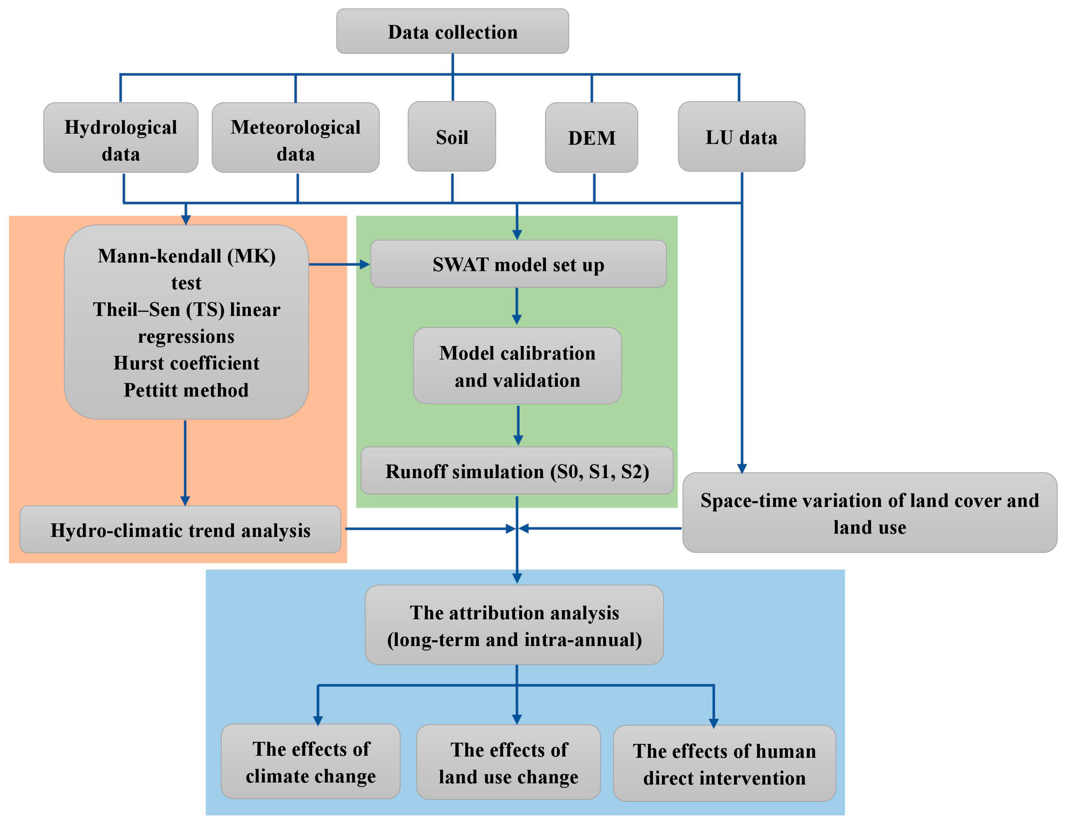
2. Materials and Methods
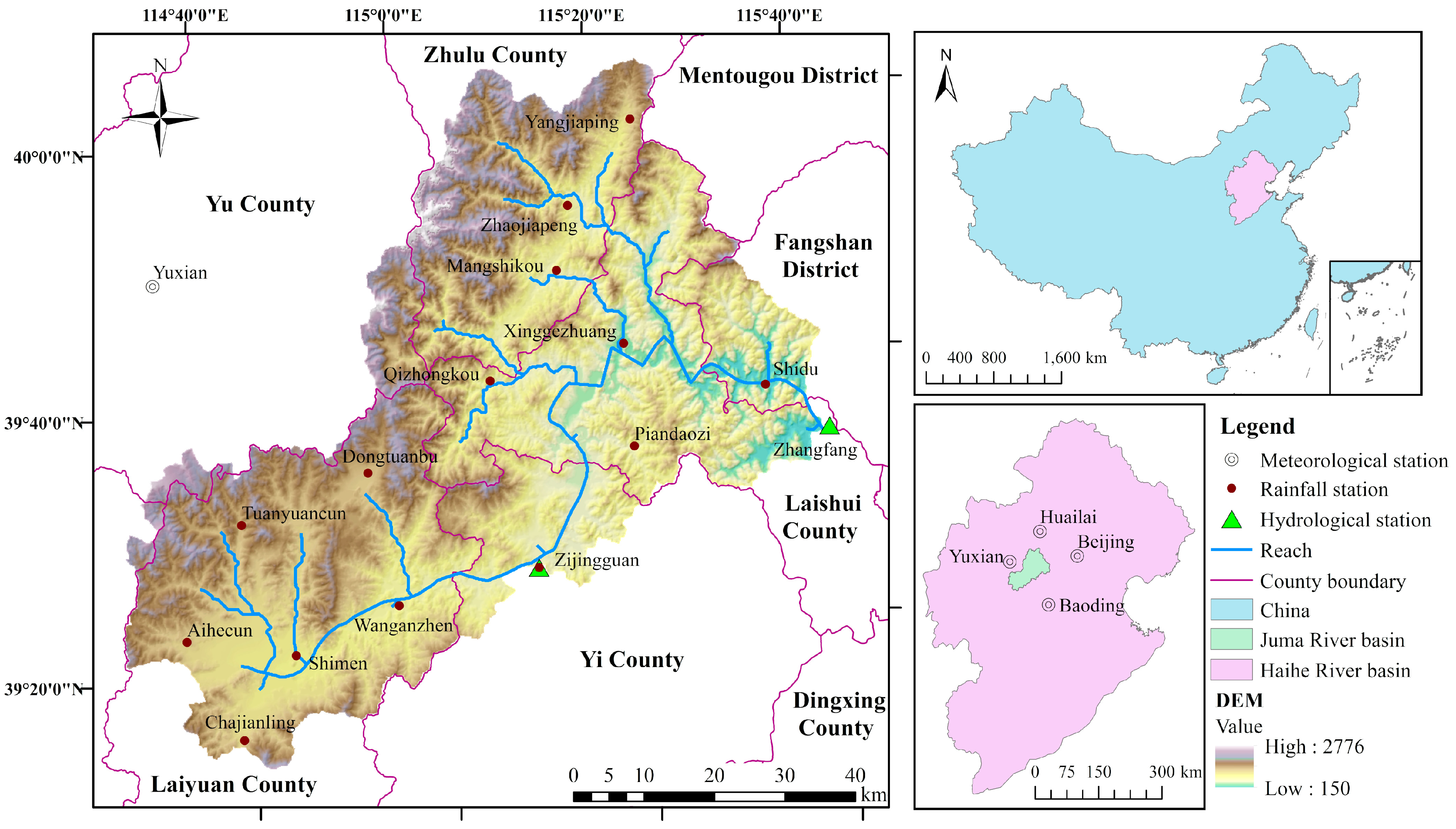
2.1. Study Area
2.2. Data Collection
2.3. Hydro-Climatic Trend Analysis
2.4. SWAT Model Set Up and Calibration
2.4.1. Model Description
2.4.2. Model Calibration and Validation
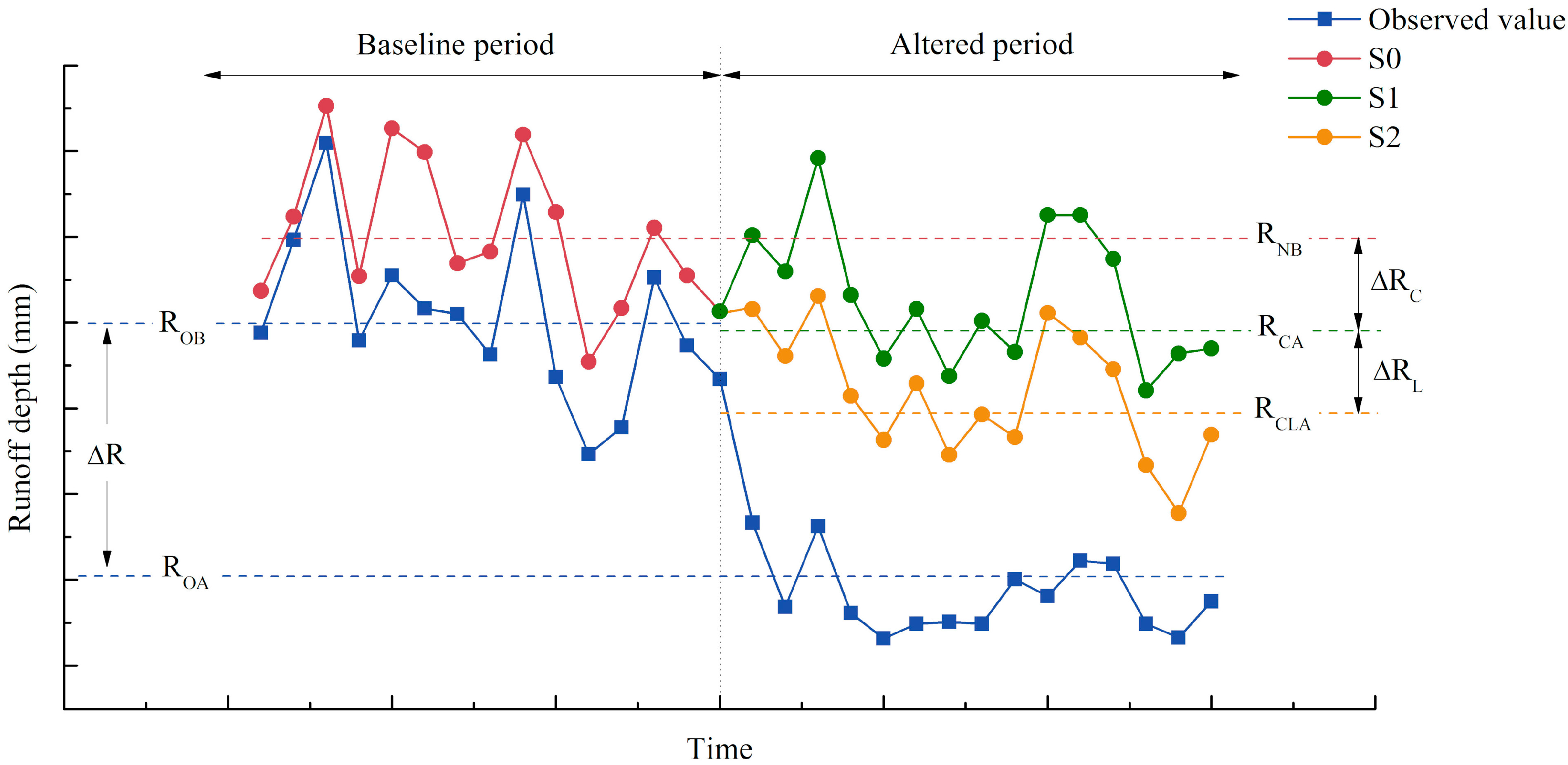
2.4.3. Evaluating the Relative Contribution of Climate, Land Use Change, and Direct Human Intervention
3. Results
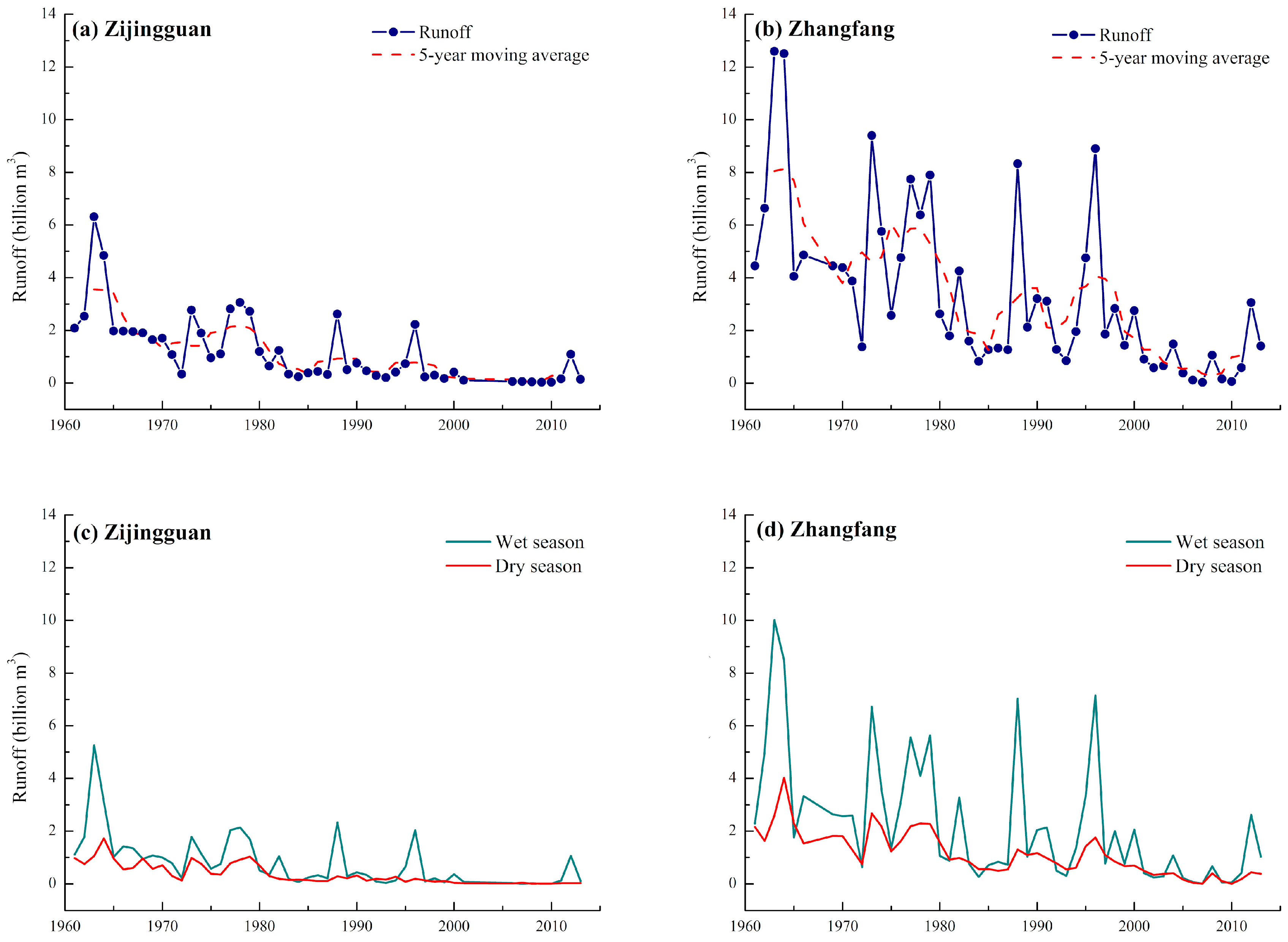
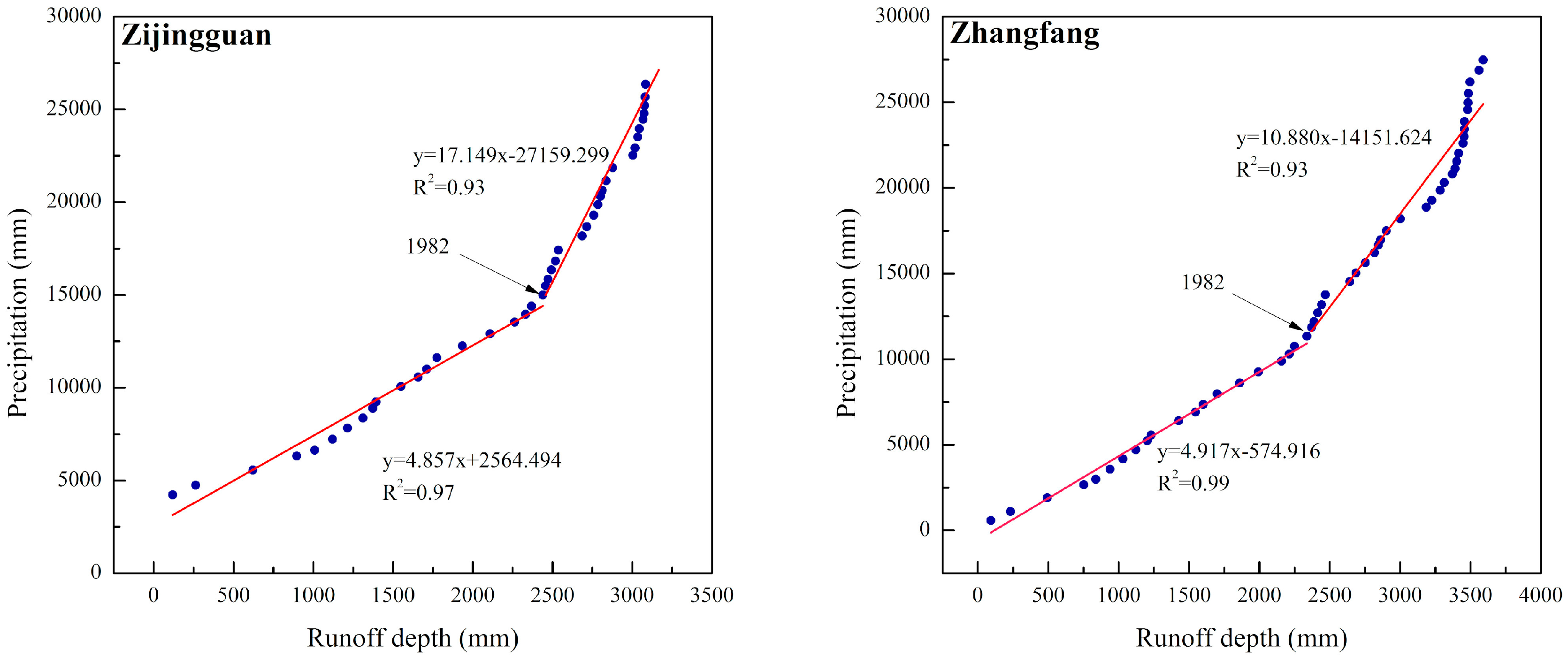
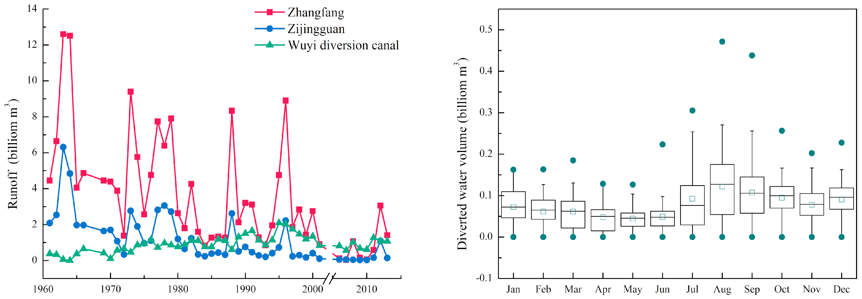
3.1. Changing Trends of Observed Runoff
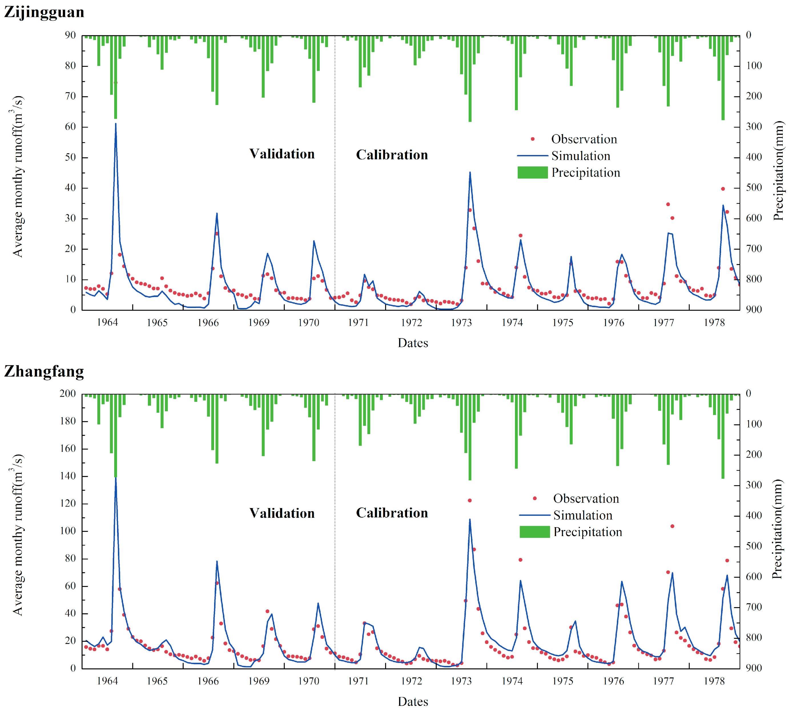
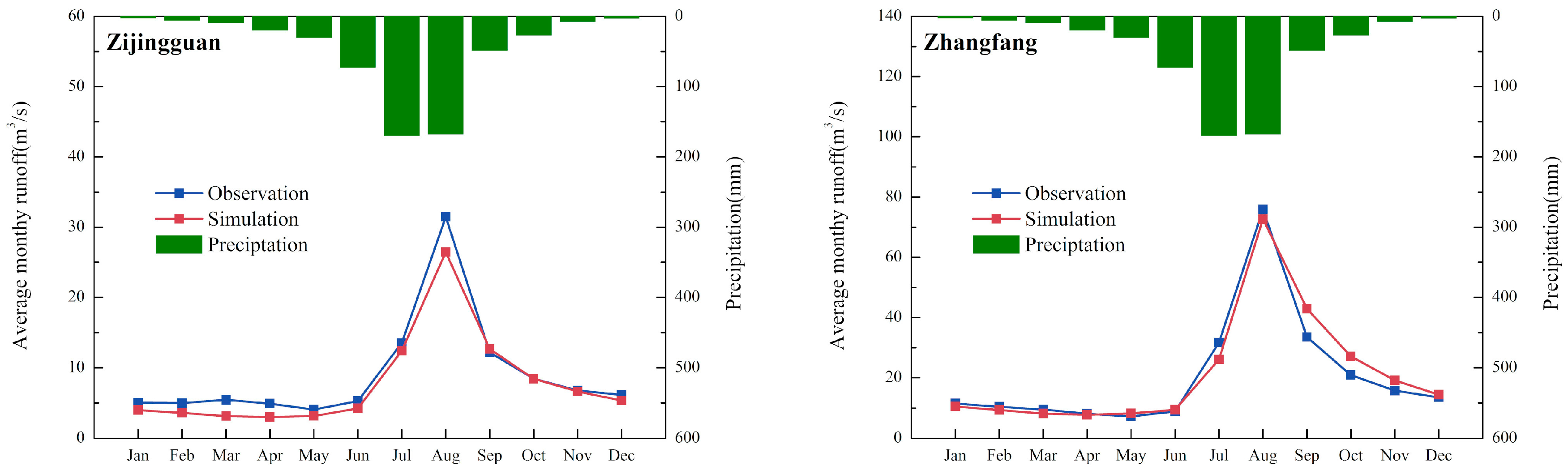
3.2. Model Valuation
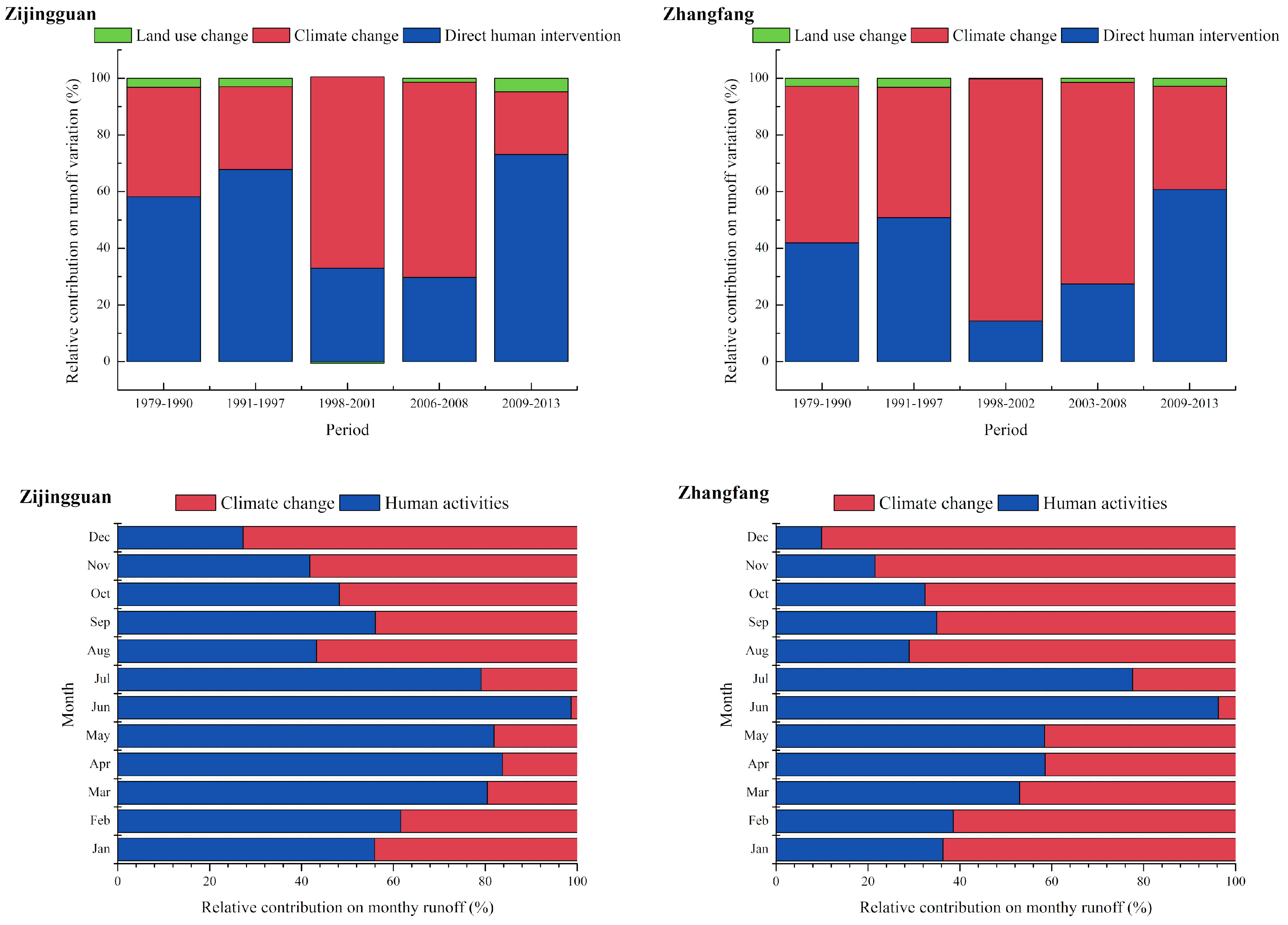
3.3. Contributions of Different Factors to Runoff Change
4. Discussion
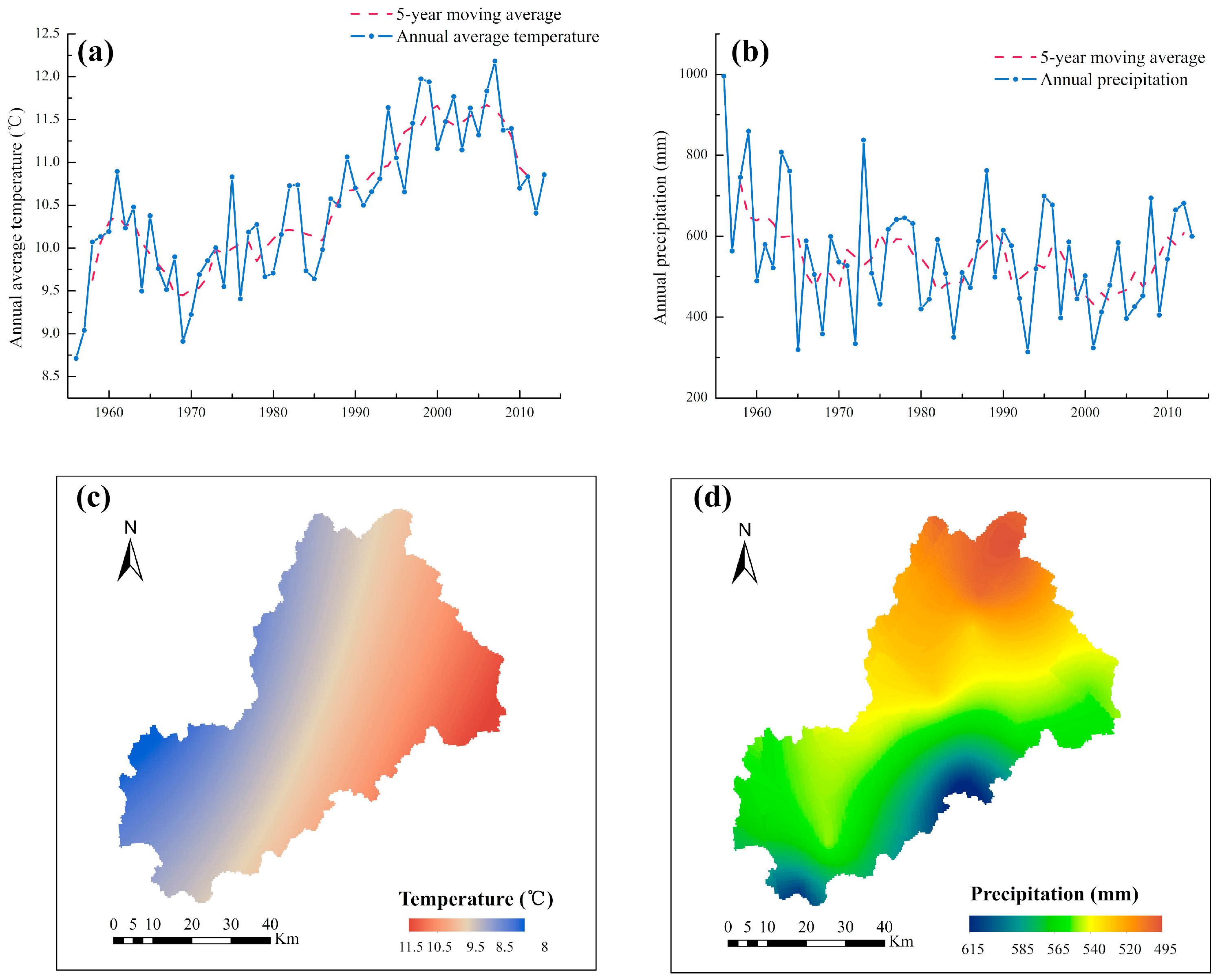
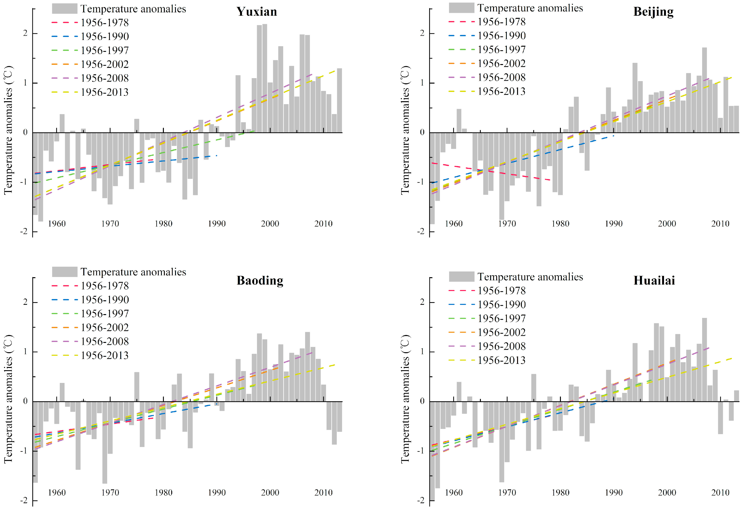
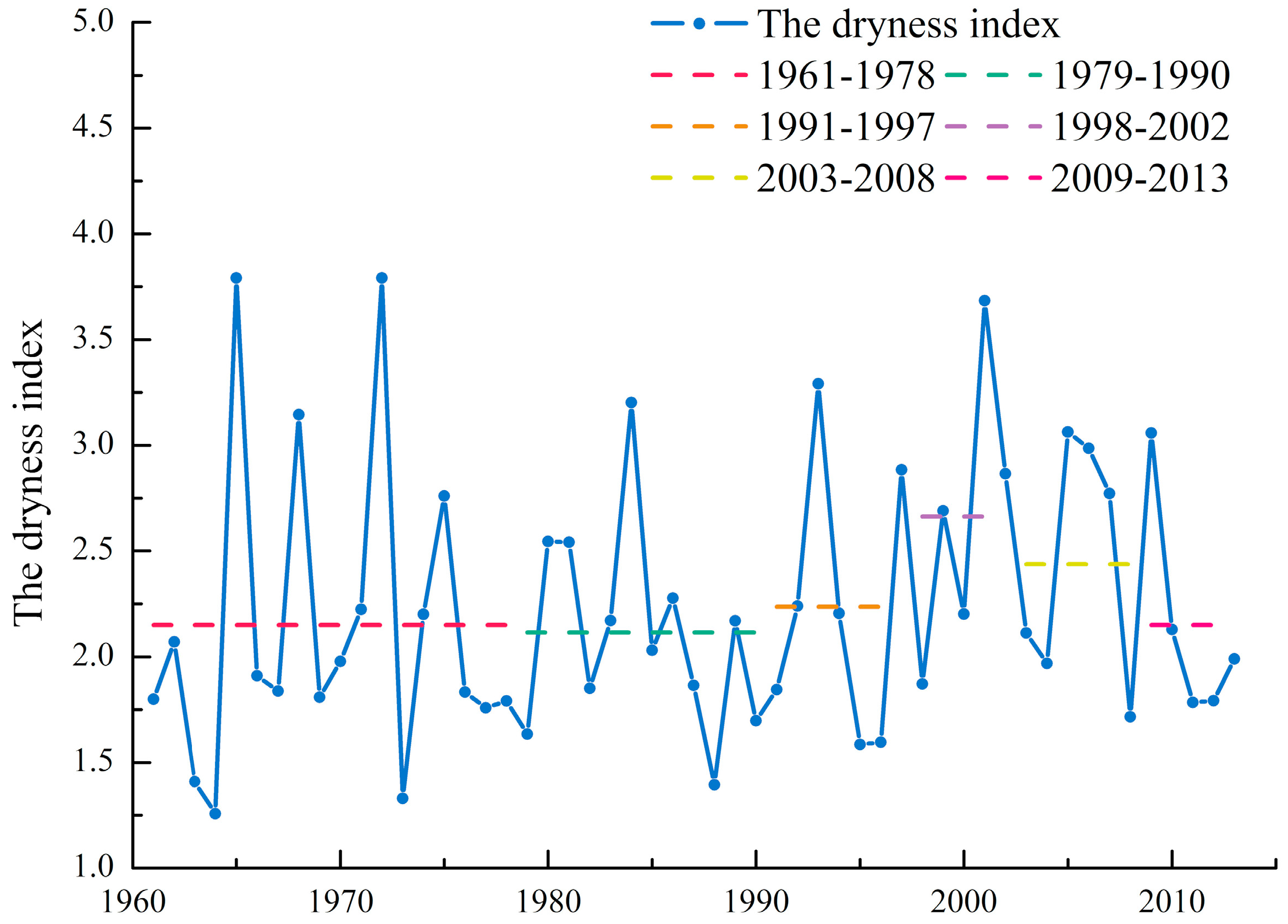
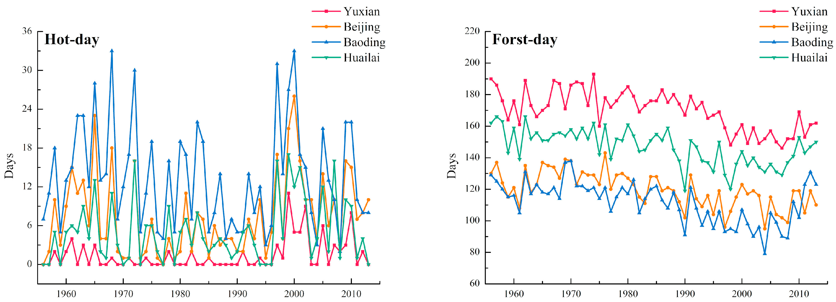
4.1. The Effects of Climate Change on Runoff
4.2. The Effects of Land Use Change on Runoff
4.3. The Combined Effects of Climate Change and Human Direct Intervention on Runoff
4.4. Uncertainty Analysis
5. Conclusions
Supplementary Materials
Author Contributions
Funding
Acknowledgments
Conflicts of Interest
Appendix A

| Station | Period | Change Rate (°C/year) | The Significance Level |
|---|---|---|---|
| Yuxian | Annual | 0.05 | 0.001 |
| Hot-day | 0 | - | |
| Frost-day | −0.54 | 0.001 | |
| Beijing | Annual | 0.04 | 0.001 |
| Hot-day | 0.01 | 0.05 | |
| Frost-day | −0.43 | 0.001 | |
| Baoding | Annual | 0.03 | 0.001 |
| Hot-day | 0 | - | |
| Frost-day | −0.50 | 0.001 | |
| Huailai | Annual | 0.03 | 0.001 |
| Hot-day | 0 | - | |
| Frost-day | −0.44 | 0.001 |
| Station | Change Rate (mm/year) | The Significance Level | Month | Change Rate (mm/year) | The Significance Level |
|---|---|---|---|---|---|
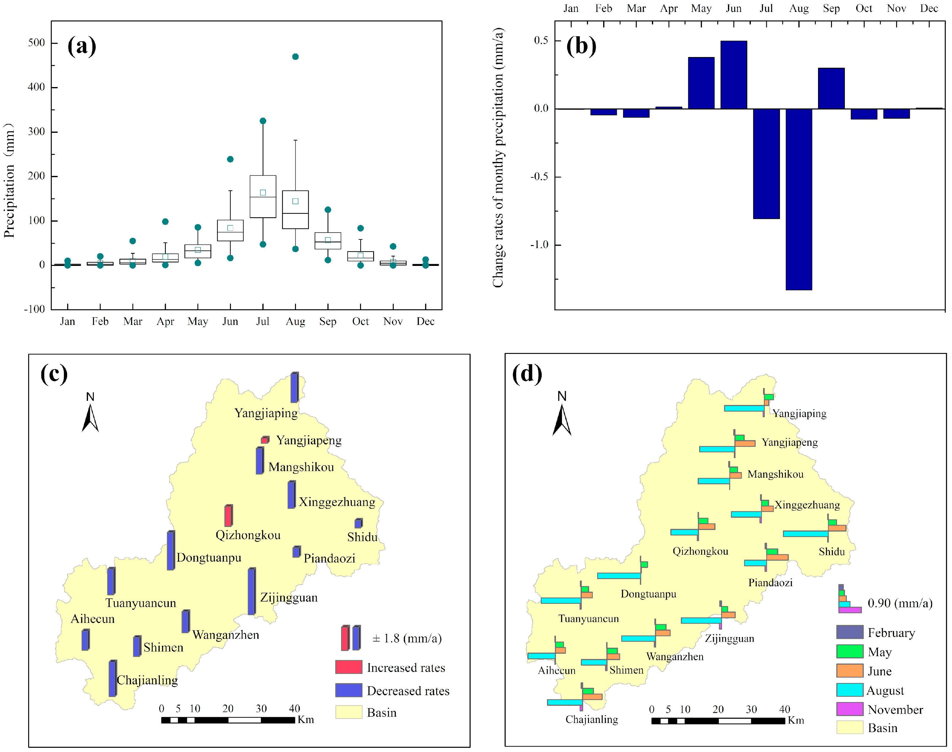
| Xinggezhuang | −2.121 | 0.1 | January | −0.002 | - |
| Zijingguan | −3.681 | 0.05 | February | −0.044 | 0.1 |
| Yangjiaping | −2.314 | 0.05 | March | −0.062 | - |
| Shimen | −1.547 | - | April | 0.015 | - |
| Aihecun | −1.566 | - | May | 0.379 | 0.05 |
| Dongtuanbao | −3.061 | 0.05 | June | 0.499 | - |
| Qizhongkou | 1.558 | - | July | −0.806 | - |
| Mangshikou | −2.080 | 0.05 | August | −1.330 | 0.05 |
| Piandaozi | −0.760 | - | September | 0.300 | - |
| Shidu | −0.612 | - | October | −0.076 | - |
| Zhaojiapeng | 0.390 | - | November | −0.069 | 0.1 |
| Chajianling | −2.830 | 0.1 | December | 0.007 | - |
| Wanganzhen | −1.722 | - | |||
| Tuanyuancun | −2.100 | 0.1 |


References
- Vorosmarty, C.J.; Green, P.; Salisbury, J.; Lammers, R.B. Global water resources: Vulnerability from climate change and population growth. Science 2000, 289, 284–288. [Google Scholar] [CrossRef]
- Moisello, U.; Todeschini, S.; Vullo, F. The effects of water management on annual maximum floods of Lake Como and River Adda at Lecco (Italy). Civ. Eng. Environ. Syst. 2013, 30, 56–71. [Google Scholar] [CrossRef]
- Oki, T.; Kanae, S. Global hydrological cycles and world water resources. Science 2006, 313, 1068–1072. [Google Scholar] [CrossRef]
- Todeschini, S. Trends in long daily rainfall series of Lombardia (northern Italy) affecting urban stormwater control. Int. J. Climatol. 2012, 32, 900–919. [Google Scholar] [CrossRef]
- Barnett, T.P.; Adam, J.C.; Lettenmaier, D.P. Potential impacts of a warming climate on water availability in snow-dominated regions. Nature 2005, 438, 303–309. [Google Scholar] [CrossRef]
- Deb, P.; Babel, M.S.; Denis, A.F. Multi-GCMs approach for assessing climate change impact on water resources in Thailand. Model. Earth Syst. Environ. 2018, 4, 825–839. [Google Scholar] [CrossRef]
- McCabe, G.J.; Wolock, D.M. Independent effects of temperature and precipitation on modeled runoff in the conterminous United States. Water Resour. Res. 2011, 47. [Google Scholar] [CrossRef]
- Bao, Z.; Zhang, J.; Wang, G.; Fu, G.; He, R.; Yan, X.; Jin, J.; Liu, Y.; Zhang, A. Attribution for decreasing streamflow of the Haihe River basin, northern China: Climate variability or human activities? J. Hydrol. 2012, 460–461, 117–129. [Google Scholar] [CrossRef]
- Li, Y.; Chang, J.; Wang, Y.; Jin, W.; Guo, A. Spatiotemporal Impacts of Climate, Land Cover Change and Direct Human Activities on Runoff Variations in the Wei River Basin, China. Water 2016, 8, 220. [Google Scholar] [CrossRef]
- Zhang, K.; Li, L.; Bai, P.; Li, J.; Liu, Y. Influence of climate variability and human activities on stream flow variation in the past 50 years in Taoer River, Northeast China. J. Geogr. Sci. 2017, 27, 481–496. [Google Scholar] [CrossRef]
- Zimmermann, B.; Elsenbeer, H.; de Moraes, J.M. The influence of land-use changes on soil hydraulic properties: Implications for runoff generation. For. Ecol. Manag. 2006, 222, 29–38. [Google Scholar] [CrossRef]
- Germer, S.; Neill, C.; Krusche, A.V.; Elsenbeer, H. Influence of land-use change on near-surface hydrological processes: Undisturbed forest to pasture. J. Hydrol. 2010, 380, 473–480. [Google Scholar] [CrossRef]
- García-Ruiz, J.M.; Regüés, D.; Alvera, B.; Lana-Renault, N.; Serrano-Muela, P.; Nadal-Romero, E.; Navas, A.; Latron, J.; Martí-Bono, C.; Arnáez, J. Flood generation and sediment transport in experimental catchments affected by land use changes in the central Pyrenees. J. Hydrol. 2008, 356, 245–260. [Google Scholar] [CrossRef]
- Ren, L.; Wang, M.; Li, C.; Zhang, W. Impacts of human activity on river runoff in the northern area of China. J. Hydrol. 2002, 261, 204–217. [Google Scholar] [CrossRef]
- He, Y.; Lin, K.; Chen, X. Effect of Land Use and Climate Change on Runoff in the Dongjiang Basin of South China. Math. Probl. Eng. 2013, 2013, 1–14. [Google Scholar] [CrossRef]
- Huo, Z.; Feng, S.; Kang, S.; Li, W.; Chen, S. Effect of climate changes and water-related human activities on annual stream flows of the Shiyang river basin in arid north-west China. Hydrol. Processes 2008, 22, 3155–3167. [Google Scholar] [CrossRef]
- Beguería, S.; López-Moreno, J.I.; Lorente, A.; Seeger, M.; García-Ruiz, J.M. Assessing the Effect of Climate Oscillations and Land-use Changes on Streamflow in the Central Spanish Pyrenees. AMBIO J. Hum. Environ. 2003, 32, 283–286. [Google Scholar] [CrossRef]
- Liang, W.; Bai, D.; Wang, F.; Fu, B.; Yan, J.; Wang, S.; Yang, Y.; Long, D.; Feng, M. Quantifying the impacts of climate change and ecological restoration on streamflow changes based on a Budyko hydrological model in China’s Loess Plateau. Water Resour. Res. 2015, 51, 6500–6519. [Google Scholar] [CrossRef]
- Gao, G.; Fu, B.; Wang, S.; Liang, W.; Jiang, X. Determining the hydrological responses to climate variability and land use/cover change in the Loess Plateau with the Budyko framework. Sci. Total Environ. 2016, 557, 331–342. [Google Scholar] [CrossRef]
- Wang, D.; Hejazi, M. Quantifying the relative contribution of the climate and direct human impacts on mean annual streamflow in the contiguous United States. Water Resour. Res. 2011, 47. [Google Scholar] [CrossRef]
- Yin, J.; He, F.; Xiong, Y.J.; Qiu, G.Y. Effects of land use/land cover and climate changes on surface runoff in a semi-humid and semi-arid transition zone in northwest China. Hydrol. Earth Syst. Sci. 2017, 21, 183–196. [Google Scholar] [CrossRef]
- Luo, K.; Tao, F.; Moiwo, J.P.; Xiao, D. Attribution of hydrological change in Heihe River Basin to climate and land use change in the past three decades. Sci. Rep. 2016, 6, 33704. [Google Scholar] [CrossRef]
- Wang, G.; Xia, J.; Chen, J. Quantification of effects of climate variations and human activities on runoff by a monthly water balance model: A case study of the Chaobai River basin in northern China. Water Resour. Res. 2009, 45. [Google Scholar] [CrossRef]
- Ahn, K.-H.; Merwade, V. Quantifying the relative impact of climate and human activities on streamflow. J. Hydrol. 2014, 515, 257–266. [Google Scholar] [CrossRef]
- Wu, J.; Miao, C.; Zhang, X.; Yang, T.; Duan, Q. Detecting the quantitative hydrological response to changes in climate and human activities. Sci. Total Environ. 2017, 586, 328–337. [Google Scholar] [CrossRef]
- Chawla, I.; Mujumdar, P.P. Isolating the impacts of land use and climate change on streamflow. Hydrol. Earth Syst. Sci. 2015, 19, 3633–3651. [Google Scholar] [CrossRef]
- Ma, X.; Lu, X.X.; van Noordwijk, M.; Li, J.T.; Xu, J.C. Attribution of climate change, vegetation restoration, and engineering measures to the reduction of suspended sediment in the Kejie catchment, southwest China. Hydrol. Earth Syst. Sci. 2014, 18, 1979–1994. [Google Scholar] [CrossRef]
- Wang, X. Advances in separating effects of climate variability and human activity on stream discharge: An overview. Adv. Water Resour. 2014, 71, 209–218. [Google Scholar] [CrossRef]
- Li, Z.; Liu, W.; Zhang, X.; Zheng, F. Impacts of land use change and climate variability on hydrology in an agricultural catchment on the Loess Plateau of China. J. Hydrol. 2009, 377, 35–42. [Google Scholar] [CrossRef]
- Xia, J.; Feng, H.; Zhan, C.-S.; Niu, C. Determination of a reasonable percentage for ecological water-use in the Haihe River basin, China. Pedosphere 2006, 16, 33–42. [Google Scholar] [CrossRef]
- Yang, H. Water, environment and food security: A case study of the Haihe River basin in China. River Basin Manag. II 2003, 60. [Google Scholar] [CrossRef]
- Xia, J.; Zhang, L.; Liu, C.; Yu, J. Towards better water security in North China. Water Resour. Manag. 2006, 21, 233–247. [Google Scholar] [CrossRef]
- Wu, G.; Chen, S.; Su, R.; Jia, M.; Li, W. Temporal trend in surface water resources in Tianjin in the Haihe River Basin, China. Hydrol. Processes 2011, 25, 2141–2151. [Google Scholar] [CrossRef]
- Xu, X.; Yang, D.; Yang, H.; Lei, H. Attribution analysis based on the Budyko hypothesis for detecting the dominant cause of runoff decline in Haihe basin. J. Hydrol. 2014, 510, 530–540. [Google Scholar] [CrossRef]
- Guo, Y.; Shen, Y. Quantifying water and energy budgets and the impacts of climatic and human factors in the Haihe River Basin, China: 2. Trends and implications to water resources. J. Hydrol. 2015, 527, 251–261. [Google Scholar] [CrossRef]
- Li, R.; Zheng, H.; Huang, B.; Xu, H.; Li, Y. Dynamic Impacts of Climate and Land-Use Changes on Surface Runoff in the Mountainous Region of the Haihe River Basin, China. Adv. Meteorol. 2018, 2018, 3287343. [Google Scholar] [CrossRef]
- Yang, Y.; Tian, F. Abrupt change of runoff and its major driving factors in Haihe River Catchment, China. J. Hydrol. 2009, 374, 373–383. [Google Scholar] [CrossRef]
- Wang, W.; Shao, Q.; Yang, T.; Peng, S.; Xing, W.; Sun, F.; Luo, Y. Quantitative assessment of the impact of climate variability and human activities on runoff changes: A case study in four catchments of the Haihe River basin, China. Hydrol. Processes 2013, 27, 1158–1174. [Google Scholar] [CrossRef]
- Lu, S.; Wu, B.; Wei, Y.; Yan, N.; Wang, H.; Guo, S. Quantifying impacts of climate variability and human activities on the hydrological system of the Haihe River Basin, China. Environ. Earth Sci. 2014, 73, 1491–1503. [Google Scholar] [CrossRef]
- Lei, H.; Yang, D.; Huang, M. Impacts of climate change and vegetation dynamics on runoff in the mountainous region of the Haihe River basin in the past five decades. J. Hydrol. 2014, 511, 786–799. [Google Scholar] [CrossRef]
- Liu, J.; Kuang, W.; Zhang, Z.; Xu, X.; Qin, Y.; Ning, J.; Zhou, W.; Zhang, S.; Li, R.; Yan, C.; et al. Spatiotemporal characteristics, patterns, and causes of land-use changes in China since the late 1980s. J. Geogr. Sci. 2014, 24, 195–210. [Google Scholar] [CrossRef]
- Kendall, M. Rank Correlation Measures; Charles Griffin: London, UK, 1975; p. 202. [Google Scholar]
- Yadav, S.; Deb, P.; Kumar, S.; Pandey, V.; Pandey, P.K. Trends in major and minor meteorological variables and their influence on reference evapotranspiration for mid Himalayan region at east Sikkim, India. J. Mt. Sci. 2016, 13, 302–315. [Google Scholar] [CrossRef]
- Mann, H.B. Nonparametric tests against trend. Econ. J. Econ. Soc. 1945, 13, 245–259. [Google Scholar] [CrossRef]
- Sen, P.K. Estimates of the regression coefficient based on Kendall’s tau. J. Am. Stat. Assoc. 1968, 63, 1379–1389. [Google Scholar] [CrossRef]
- Theil, H. A rank-invariant method of linear and polynomial regression analysis. In Henri Theil’s Contributions to Economics and Econometrics; Springer: Dordrecht, The Netherlands, 1992; pp. 345–381. [Google Scholar]
- Hurst, H.E. Long-term storage capacity of reservoirs. Trans. Am. Soc. Civ. Eng. 1951, 116, 770–799. [Google Scholar]
- Matalas, N.; Wallis, J. Small sample properties of Hand K--estimators of the Hurst coefficient h. Water Resour. Res. 1970, 6, 1583–1594. [Google Scholar]
- Pettitt, A. A non-parametric approach to the change-point problem. Appl. Stat. 1979, 28, 126–135. [Google Scholar] [CrossRef]
- Arnold, J.G.; Srinivasan, R.; Muttiah, R.S.; Williams, J.R. Large area hydrologic modeling and assessment—Part 1: Model development. J. Am. Water Resour. Assoc. 1998, 34, 73–89. [Google Scholar] [CrossRef]
- Santhi, C.; Arnold, J.G.; Williams, J.R.; Dugas, W.A.; Srinivasan, R.; Hauck, L.M. Validation of the swat model on a large rwer basin with point and nonpoint sources. JAWRA J. Am. Water Resour. Assoc. 2001, 37, 1169–1188. [Google Scholar] [CrossRef]
- Marhaento, H.; Booij, M.J.; Rientjes, T.H.M.; Hoekstra, A.Y. Attribution of changes in the water balance of a tropical catchment to land use change using the SWAT model. Hydrol. Processes 2017, 31, 2029–2040. [Google Scholar] [CrossRef]
- Abbaspour, K. Calibration of hydrologic models: When is a model calibrated. In Proceedings of the MODSIM 2005 International Congress on Modelling and Simulation, Modelling and Simulation Society of Australia and New Zealand, Melbourne, Australia, 12–15 December 2005. [Google Scholar]
- Abbaspour, K.C. SWAT-CUP 2012: SWAT Calibration and Uncertainty Programs—A User Manual; Eawag: Dübendorf, Switzerland, 2013; p. 103. [Google Scholar]
- Zhang, A.; Zhang, C.; Fu, G.; Wang, B.; Bao, Z.; Zheng, H. Assessments of Impacts of Climate Change and Human Activities on Runoff with SWAT for the Huifa River Basin, Northeast China. Water Resour. Manag. 2012, 26, 2199–2217. [Google Scholar] [CrossRef]
- Shi, X.; Yang, Z.; Yan, D.; Li, Y.; Yuan, Z. On hydrological response to land-use/cover change in Luanhe River basin. Adv. Water Sci. 2014, 25, 21–27. (In Chinese) [Google Scholar]
- He, S.; Nan, Z.; Zhang, L.; Yu, W. Spatial-temporal distribution of water and energy fluxes in the upper reaches of the Heihe River simulated with VIC model. J. Glaciol. Geocryol. 2015, 37, 211–225. (In Chinese) [Google Scholar]
- Moriasi, D.N.; Gitau, M.W.; Pai, N.; Daggupati, P. Hydrologic and water quality models: Performance measures and evaluation criteria. Trans. Asabe 2015, 58, 1763–1785. [Google Scholar]
- Zhang, L.; Li, L.; Xia, J.; Wang, R. Quantitative assessment of the impact of climate variability and human activities on runoff change in the Luanhe River Catchment. J. Nat. Resour. 2015, 4, 664–672. (In Chinese) [Google Scholar]
- Qian, Y.; Leung, L.R. A long-term regional simulation and observations of the hydroclimate in China. J. Geophys. Res. 2007, 112. [Google Scholar] [CrossRef]
- Peng, S.; Liu, W.; Wang, W.; Shao, Q.; Jiao, X.; Yu, Z.; Xing, W.; Xu, J.; Zhang, Z.; Luo, Y. Estimating the effects of climatic variability and human activities on streamflow in the Hutuo River basin, China. J. Hydrol. Eng. 2013, 18, 422–430. [Google Scholar] [CrossRef]
- Xu, Y.-P.; Zhang, X.; Ran, Q.; Tian, Y. Impact of climate change on hydrology of upper reaches of Qiantang River Basin, East China. J. Hydrol. 2013, 483, 51–60. [Google Scholar] [CrossRef]
- Xia, F.; Liu, X.M.; Xu, J.M.; Wang, Z.G.; Huang, J.F.; Brookes, P.C. Trends in the daily and extreme temperatures in the Qiantang River basin, China. Int. J. Climatol. 2015, 35, 57–68. [Google Scholar] [CrossRef]
- Keesstra, S.D.; van Huissteden, J.; Vandenberghe, J.; Van Dam, O.; de Gier, J.; Pleizier, I.D. Evolution of the morphology of the river Dragonja (SW Slovenia) due to land-use changes. Geomorphology 2005, 69, 191–207. [Google Scholar] [CrossRef]
- Keesstra, S.D.; van Dam, O.; Verstraeten, G.; van Huissteden, J. Changing sediment dynamics due to natural reforestation in the Dragonja catchment, SW Slovenia. Catena 2009, 78, 60–71. [Google Scholar] [CrossRef]
- Keesstra, S.D.; Bruijnzeel, L.A.; van Huissteden, J. Meso-scale catchment sediment budgets: Combining field surveys and modeling in the Dragonja catchment, southwest Slovenia. Earth Surf. Processes Landforms 2009, 34, 1547–1561. [Google Scholar] [CrossRef]
- Hao, X. Study on the Water Allocation Acheme of Juma River 2010; Tsinghua University: Beijing, China, 2010. (In Chinese) [Google Scholar]
- Meng, X.; Wu, X.B. Analysis on Flood Control Unified Regulation of Baiyangdian Wetland and its Upstream Reservoir Group. Appl. Mech. Mater. 2013, 353–356, 2591–2594. [Google Scholar] [CrossRef]
- Fan, J.; Tian, F.; Yang, Y.; Han, S.; Qiu, G. Quantifying the magnitude of the impact of climate change and human activity on runoff decline in Mian River Basin, China. Water Sci. Technol. 2010, 62, 783–791. [Google Scholar] [CrossRef]
- Pringle, C. What is hydrologic connectivity and why is it ecologically important? Hydrol. Processes 2003, 17, 2685–2689. [Google Scholar] [CrossRef]
- Bracken, L.J.; Croke, J. The concept of hydrological connectivity and its contribution to understanding runoff-dominated geomorphic systems. Hydrol. Processes 2007, 21, 1749–1763. [Google Scholar] [CrossRef]
- Masselink, R.; Temme, A.J.A.M.; Giménez, R.; Casalí, J.; Keesstra, S.D. Assessing hillslope-channel connectivity in an agricultural catchment using rare-earth oxide tracers and random forests models. Cuadernos Investig. Geográfica 2017, 43, 19–39. [Google Scholar] [CrossRef]
- Keesstra, S.; Nunes, J.P.; Saco, P.; Parsons, T.; Poeppl, R.; Masselink, R.; Cerda, A. The way forward: Can connectivity be useful to design better measuring and modelling schemes for water and sediment dynamics? Sci. Total Environ. 2018, 644, 1557–1572. [Google Scholar] [CrossRef]
- Keesstra, S.D.; Temme, A.; Schoorl, J.M.; Visser, S.M. Evaluating the hydrological component of the new catchment-scale sediment delivery model LAPSUS-D. Geomorphology 2014, 212, 97–107. [Google Scholar] [CrossRef]
- Rodrigo-Comino, J.; Martinez-Hernandez, C.; Iserloh, T.; Cerda, A. Contrasted Impact of Land Abandonment on Soil Erosion in Mediterranean Agriculture Fields. Pedosphere 2018, 28, 617–631. [Google Scholar] [CrossRef]
- Mekonnen, M.; Keesstra, S.D.; Baartman, J.E.M.; Stroosnijder, L.; Maroulis, J. Reducing sediment connectivity through man-made and natural sediment sinks in the minizr catchment, northwest ethiopia. Land Degrad. Dev. 2017, 28, 707–717. [Google Scholar] [CrossRef]
- Cerda, A.; Rodrigo-Comino, J.; Gimenez-Morera, A.; Keesstra, S.D. Hydrological and erosional impact and farmer’s perception on catch crops and weeds in citrus organic farming in Canyoles river watershed, Eastern Spain. Agric. Ecosyst. Environ. 2018, 258, 49–58. [Google Scholar] [CrossRef]
- Ji, Y.; Chen, L.; Sun, R. Temporal and Spatial Variability of Water Supply Stress in the Haihe River Basin, Northern China1. JAWRA J. Am. Water Resour. Assoc. 2012, 48, 999–1007. [Google Scholar] [CrossRef]
- Pan, Y.; Zhang, C.; Gong, H.; Yeh, P.J.F.; Shen, Y.; Guo, Y.; Huang, Z.; Li, X. Detection of human-induced evapotranspiration using GRACE satellite observations in the Haihe River basin of China. Geophys. Res. Lett. 2017, 44, 190–199. [Google Scholar] [CrossRef]
- Zou, J.; Xie, Z.; Zhan, C.; Qin, P.; Sun, Q.; Jia, B.; Xia, J. Effects of anthropogenic groundwater exploitation on land surface processes: A case study of the Haihe River Basin, northern China. J. Hydrol. 2015, 524, 625–641. [Google Scholar] [CrossRef]


| Types | Area (% of Total Area) | Wilting Point (% Vol) | Field Capacity (% Vol) | Saturation (% Vol) | Sat Hydraulic Cond (mm/h) | Matric Bulk Density (g/cm3) |
|---|---|---|---|---|---|---|
| Cambisols | 21.54 | 6.2–26.3 | 12.9–38.7 | 39.6–47.1 | 1.49–50.9 | 1.4–1.6 |
| Luvisols | 59.95 | 6.6–14.4 | 11.8–30.9 | 39.6–42.9 | 3.59–49.88 | 1.51–1.59 |
| Leptosols | 4.98 | 13.3–13.9 | 26.1–29.5 | 43.8–49.6 | 9.9–16.8 | 1.33–1.49 |
| Regosols | 10.96 | 11.4–15.6 | 22.7–28.5 | 40.4–48.3 | 4.99–15.3 | 1.37–1.58 |
| Fluvisols | 2.58 | 11.6–11.8 | 25.9–26.7 | 41.2–42.2 | 8.49–8.81 | 1.53–1.56 |
| Parameter Name | Description | Initial Range | Zijingguan | Zhangfang | ||
|---|---|---|---|---|---|---|
| Final Range | Calibrated Value | Final Range | Calibrated Value | |||
| r__CN2 | Initial SCS runoff curve number for moisture condition II | (−0.3, 0.3) | (−0.190, 0.108) | −0.162 | (−0.172, 0) | −0.12 |
| v__ALPHA_BF | Baseflow alpha factor (1/days) | (0, 1) | (0.016, 0.43) | 0.39 | (0.036, 0.318) | 0.19 |
| v__GW_DELAY | Groundwater delay time (days) | (0, 500) | (150.84, 391.96) | 195.11 | (140.84, 264.65) | 255.36 |
| v__GWQMN | Threshold depth of water in the shallow aquifer required for return flow to occur (mm H2O) | (20, 5000) | (150.49, 584.01) | 478.45 | (273.05, 581.89) | 427.5 |
| v__GW_REVAP | Groundwater “revap” coefficient. | (0.02, 0.2) | (0.109, 0.2) | 0.18 | (0.11, 0.16) | 0.14 |
| v__ESCO | Soil evaporation compensation factor | (0, 1) | (0.494, 0.887) | 0.84 | (0.429, 0.756) | 0.47 |
| v__CH_K2 | Effective hydraulic conductivity in tributary channel alluvium (mm/h) | (0.02, 150) | (69.31, 109.89) | 74.04 | (72.11, 112.89) | 78.46 |
| r__SOL_AWC | Available water capacity of the soil layer (mm H2O/mm soil) | (−0.5, −0.5) | (−0.040, 0.154) | 0.057 | (−0.081, −0.120) | 0.03 |
| r__SOL_K | Saturated hydraulic conductivity (mm/h) | (−0.5, 0.5) | (−0.0.34, 0.169) | 0.067 | (−0.154, 0.061) | −0.04 |
| Station | Period | Monthly Discharge (m3/s) | Ens | R2 | Re | |
|---|---|---|---|---|---|---|
| Simulated | Measured | |||||
| Zijingguan | calibration | 7.38 | 8.04 | 0.89 | 0.86 | 8.2% |
| Validation | 7.59 | 8.64 | 0.84 | 0.86 | 12.15% | |
| Zhangfang | calibration | 20.24 | 19.02 | 0.88 | 0.89 | −6.4% |
| Validation | 19.42 | 20.07 | 0.86 | 0.87 | 3.21% | |
| Types | Late 1970s | Late 1980s | 1995 | 2000 | 2005 | 2010 |
|---|---|---|---|---|---|---|
| Agriculture | 565.4 | 565.5 | 560.7 | 561.4 | 559.6 | 556.5 |
| Dense Forest | 1653.1 | 1653.7 | 1756.3 | 1670.7 | 1671.0 | 1670.1 |
| Shrubwood | 1138.6 | 1139.6 | 1103.6 | 1136.0 | 1136.2 | 1135.2 |
| Open Forest | 301.7 | 301.8 | 225.9 | 252.8 | 253.2 | 253.1 |
| Grass | 1011.4 | 1011.8 | 1021.3 | 1047.1 | 1046.1 | 1046.2 |
| Water Bodies | 34.0 | 34.0 | 34.1 | 34.1 | 34.1 | 34.1 |
| Urban | 29.5 | 29.5 | 34.0 | 34.2 | 36.6 | 41.0 |
| Unused Land | 1.5 | 1.5 | 1.5 | 1.5 | 1.5 | 1.5 |
© 2018 by the authors. Licensee MDPI, Basel, Switzerland. This article is an open access article distributed under the terms and conditions of the Creative Commons Attribution (CC BY) license (http://creativecommons.org/licenses/by/4.0/).
Share and Cite
Bu, J.; Lu, C.; Niu, J.; Gao, Y. Attribution of Runoff Reduction in the Juma River Basin to Climate Variation, Direct Human Intervention, and Land Use Change. Water 2018, 10, 1775. https://doi.org/10.3390/w10121775
Bu J, Lu C, Niu J, Gao Y. Attribution of Runoff Reduction in the Juma River Basin to Climate Variation, Direct Human Intervention, and Land Use Change. Water. 2018; 10(12):1775. https://doi.org/10.3390/w10121775
Chicago/Turabian StyleBu, Jingyi, Chunxia Lu, Jun Niu, and Yanchun Gao. 2018. "Attribution of Runoff Reduction in the Juma River Basin to Climate Variation, Direct Human Intervention, and Land Use Change" Water 10, no. 12: 1775. https://doi.org/10.3390/w10121775
APA StyleBu, J., Lu, C., Niu, J., & Gao, Y. (2018). Attribution of Runoff Reduction in the Juma River Basin to Climate Variation, Direct Human Intervention, and Land Use Change. Water, 10(12), 1775. https://doi.org/10.3390/w10121775