A Bias Correction Method for Rainfall Forecasts Using Backward Storm Tracking


Abstract
1. Introduction
2. Methodology
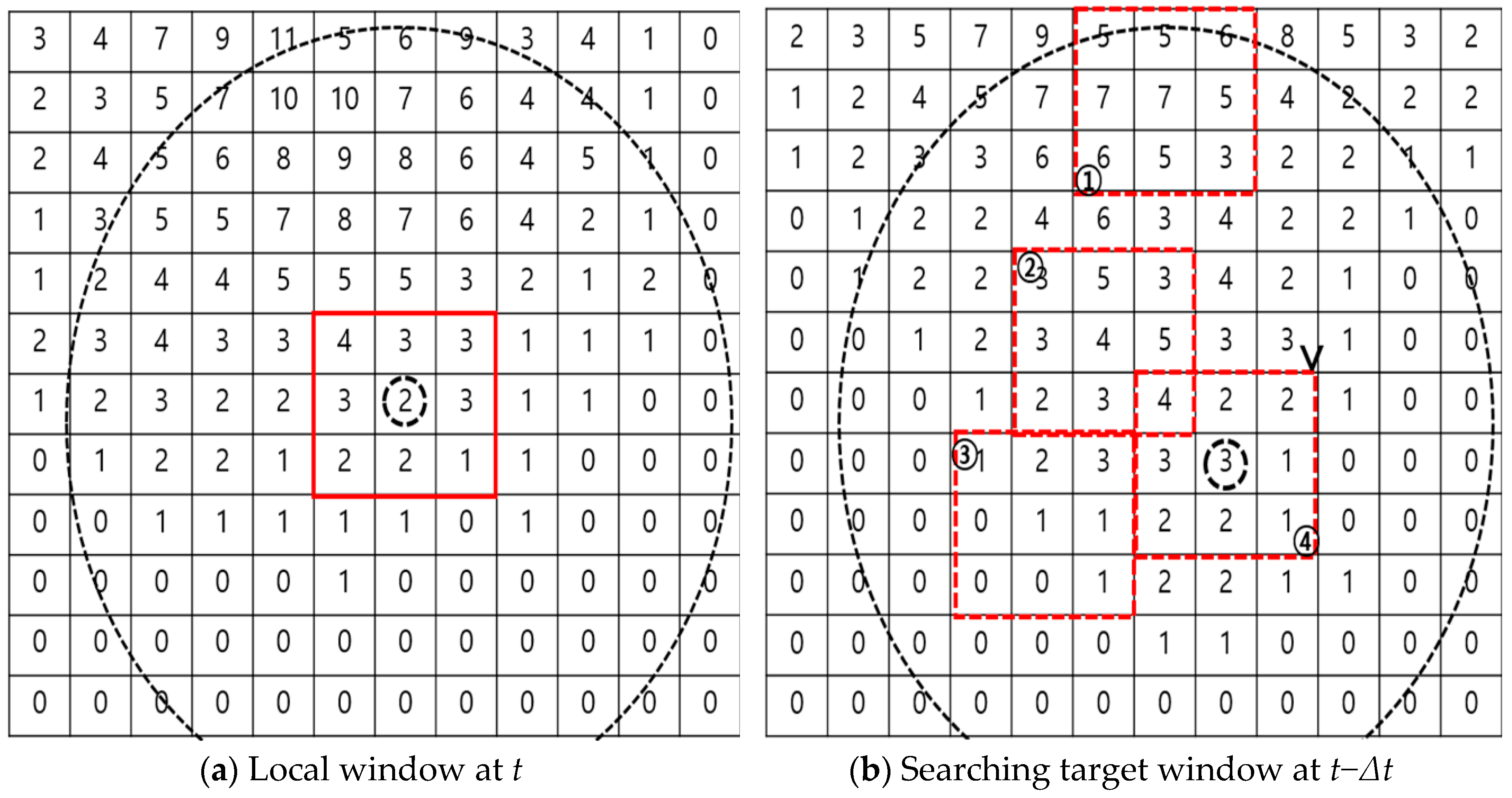
2.1. Storm Tracking
2.2. Bias Correction Ratio
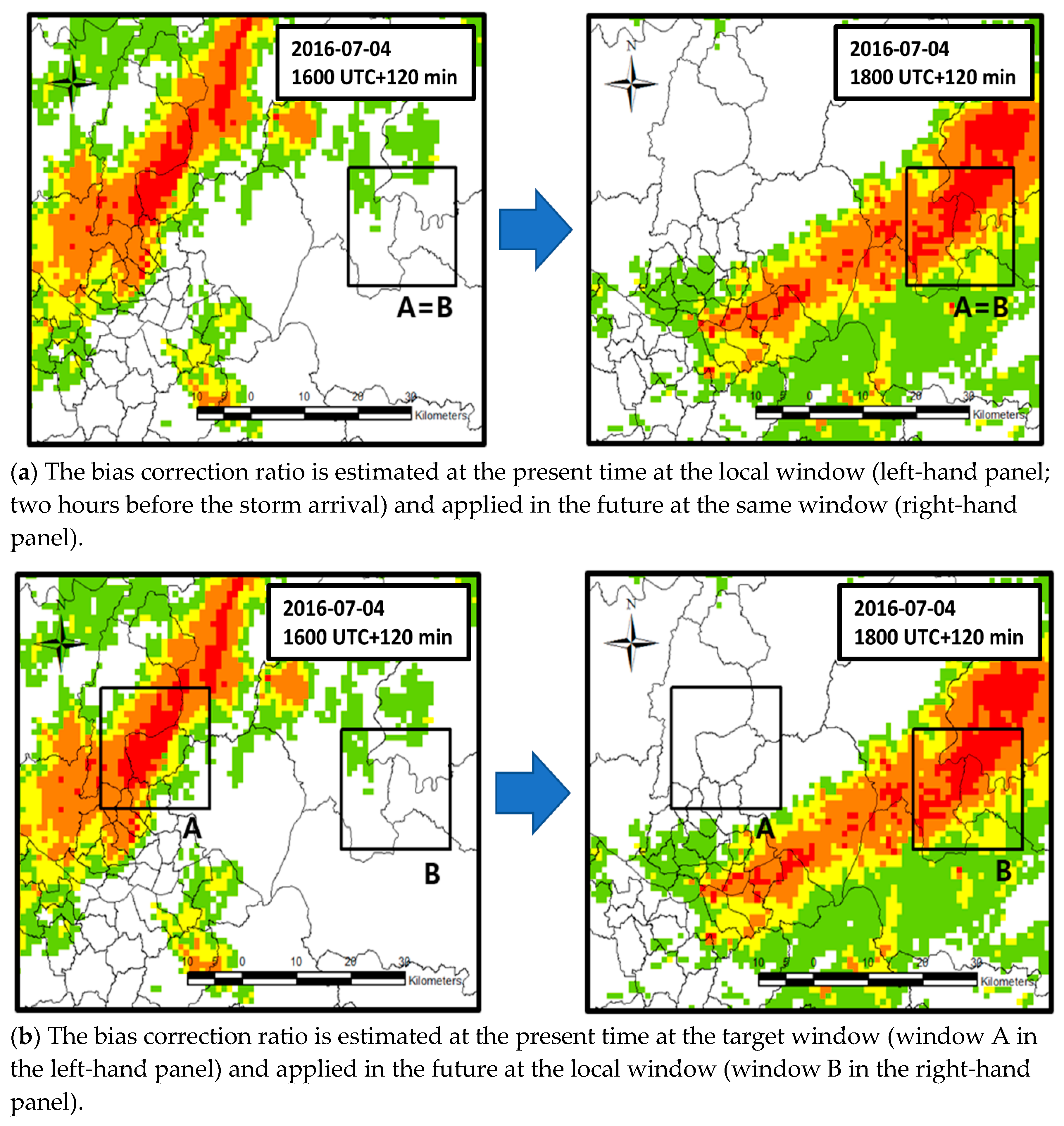
2.3. Conventional and Proposed Method for Determining the Bias Correction Ratio
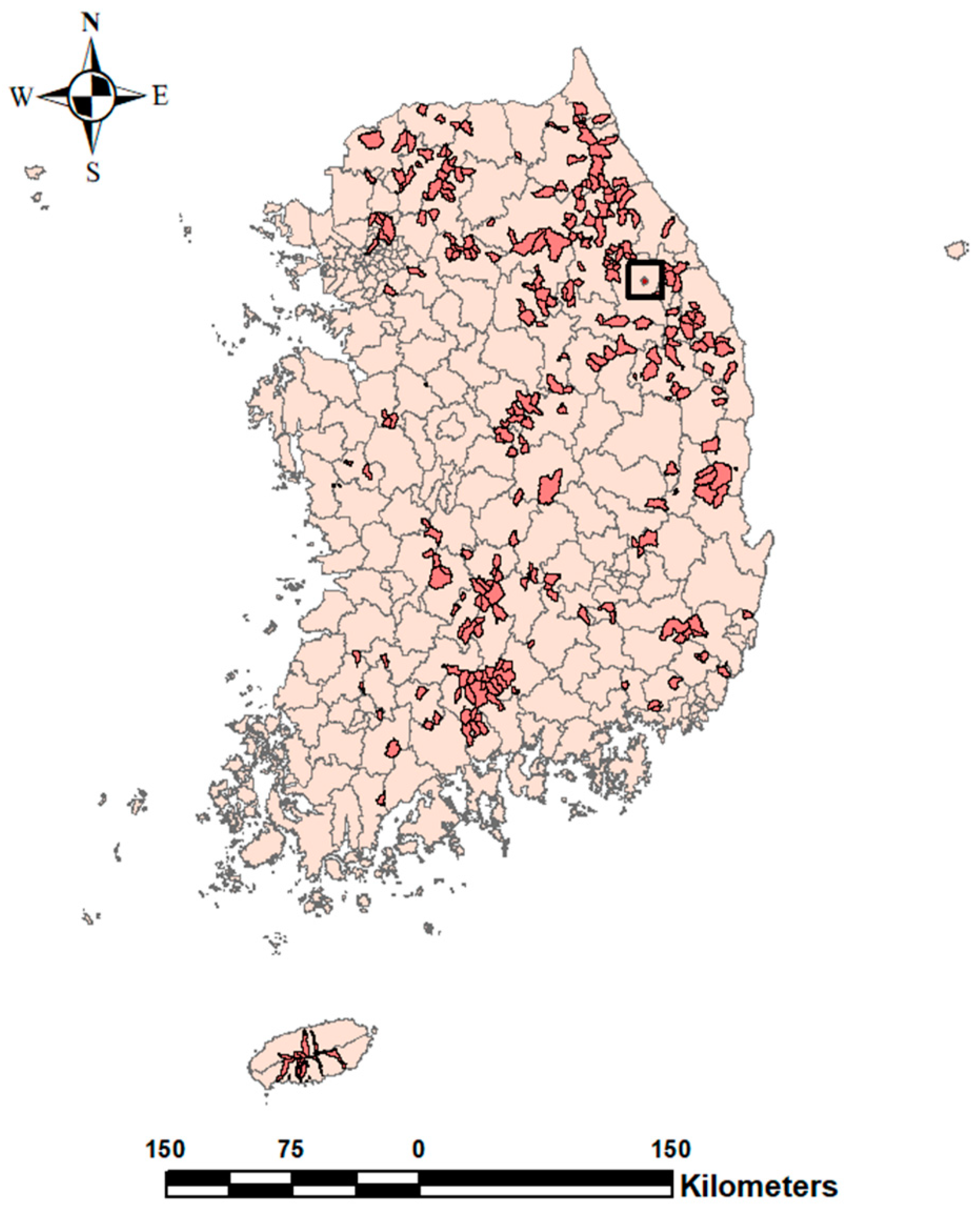
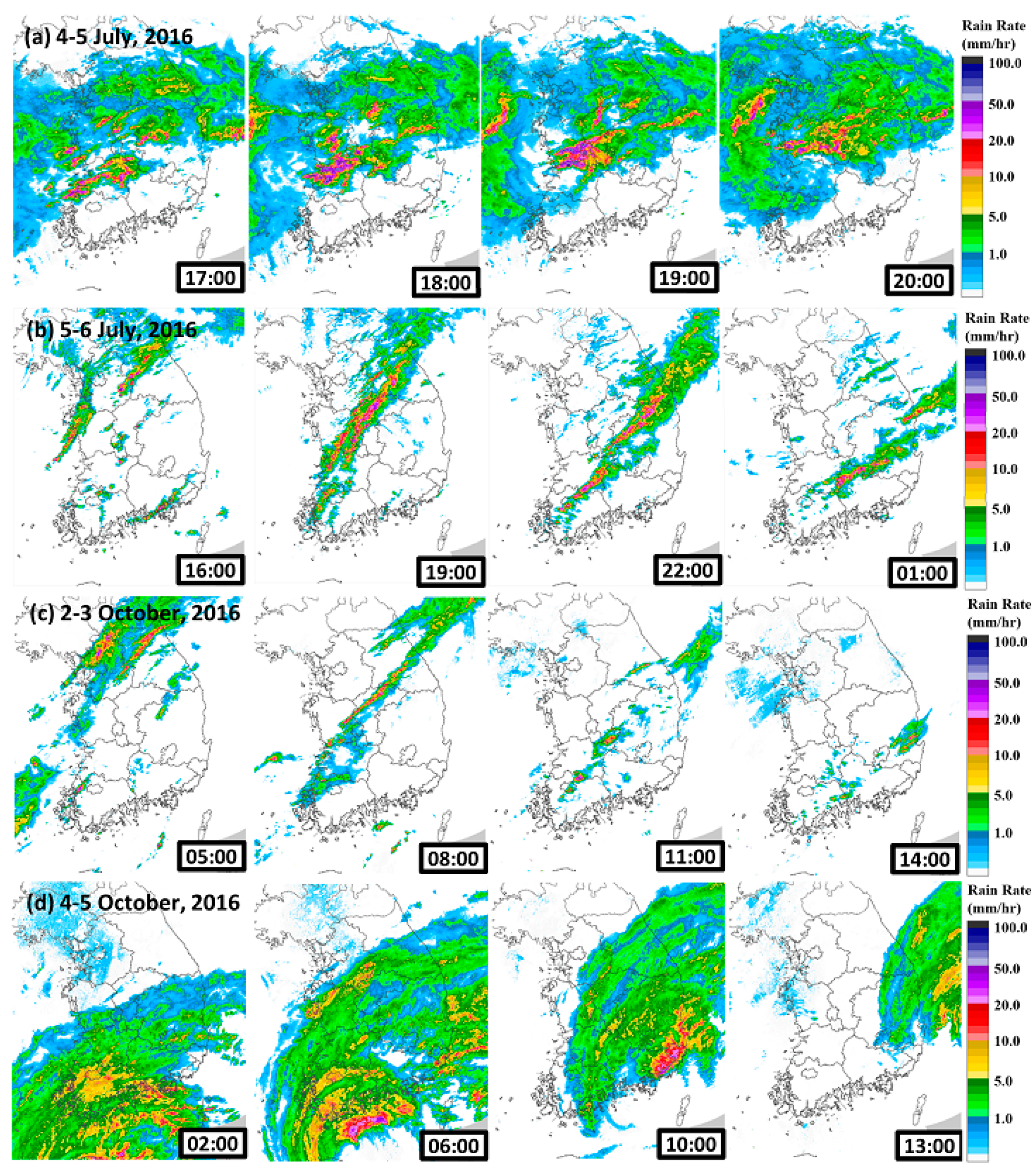
3. Study Sites and Storm Events
4. Results
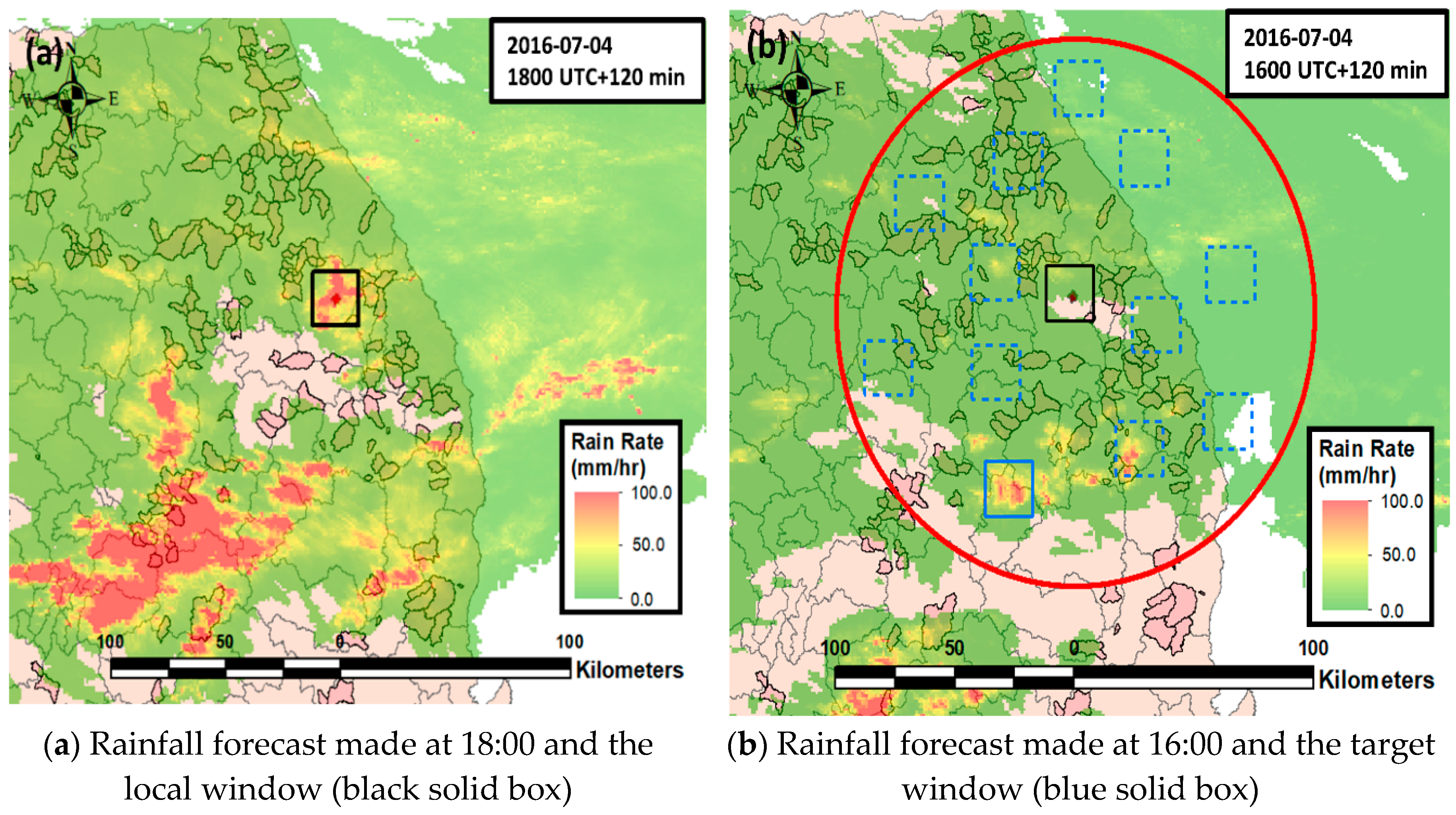
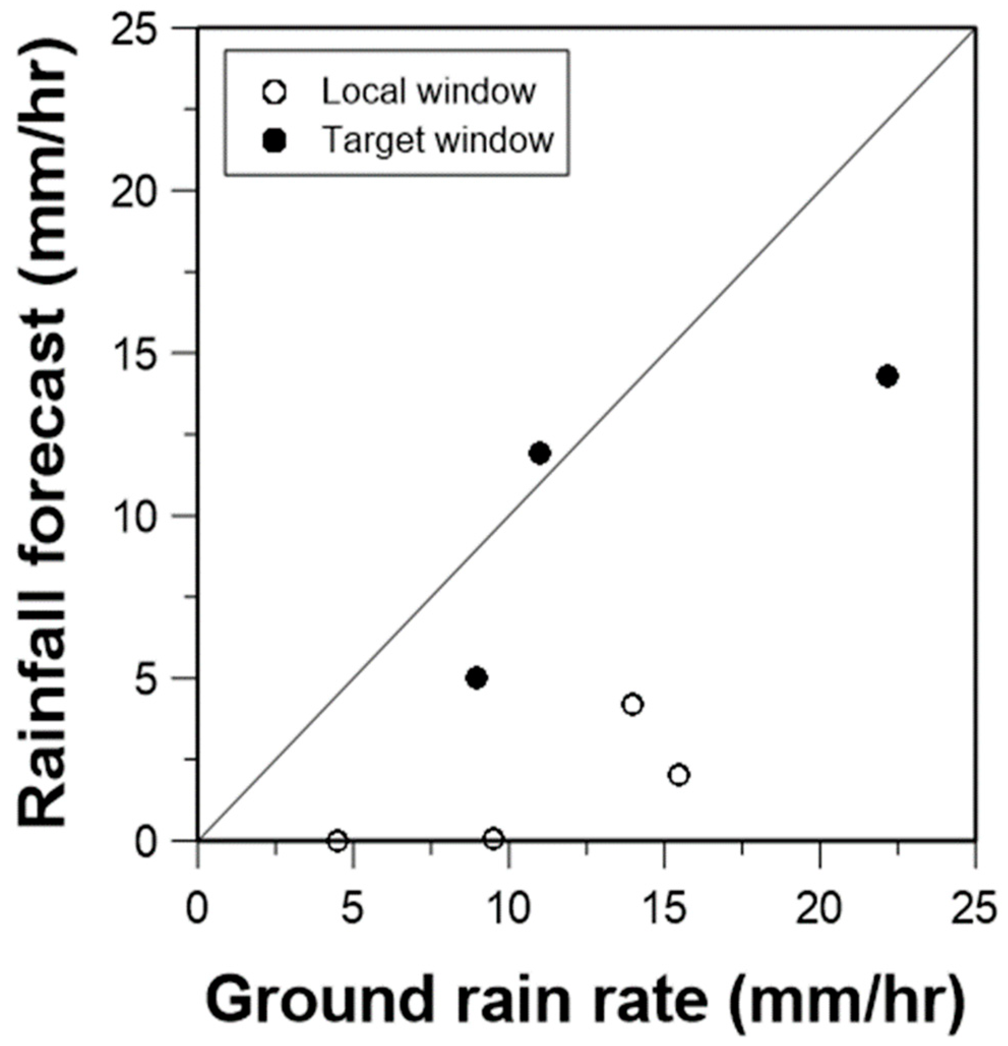
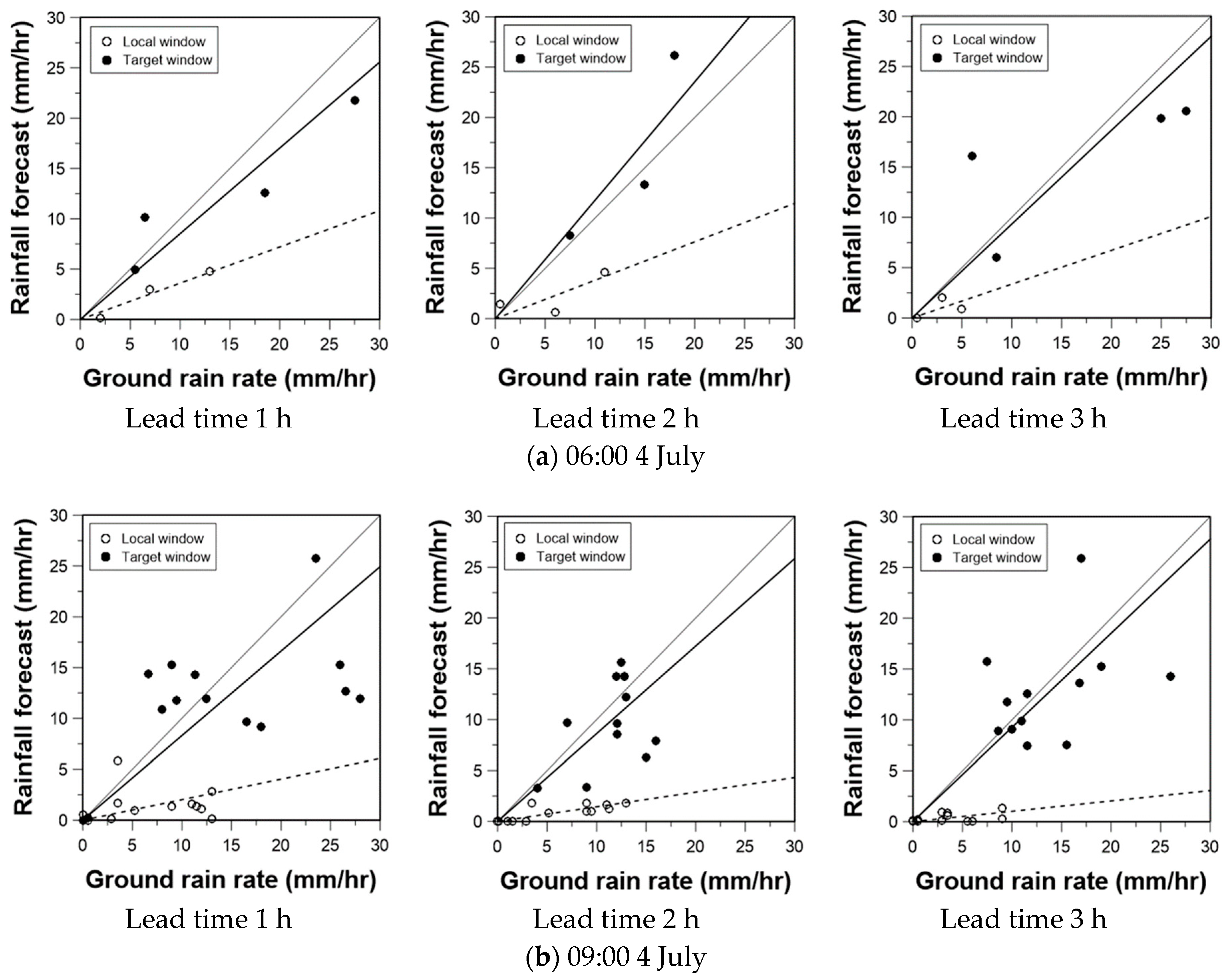
4.1. An Example Application to the Ducsanggi Valley
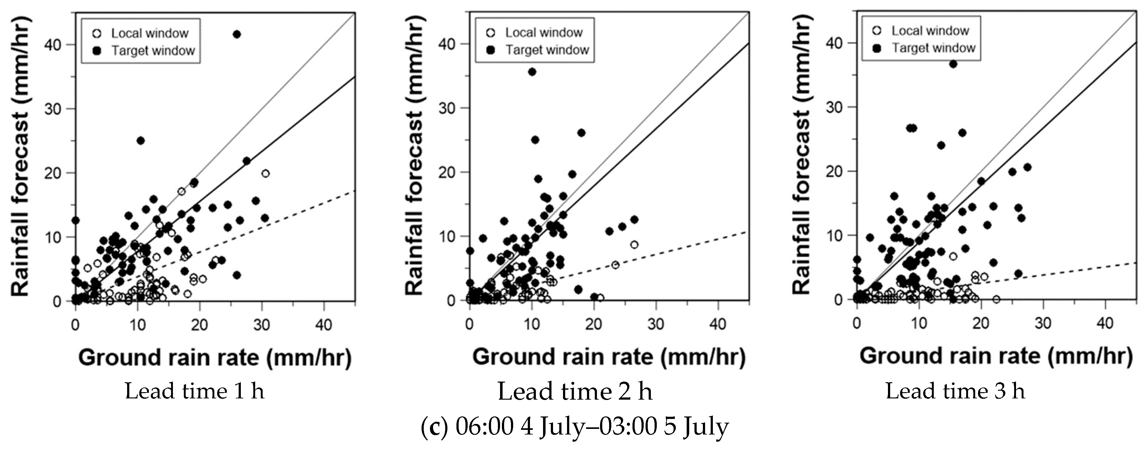
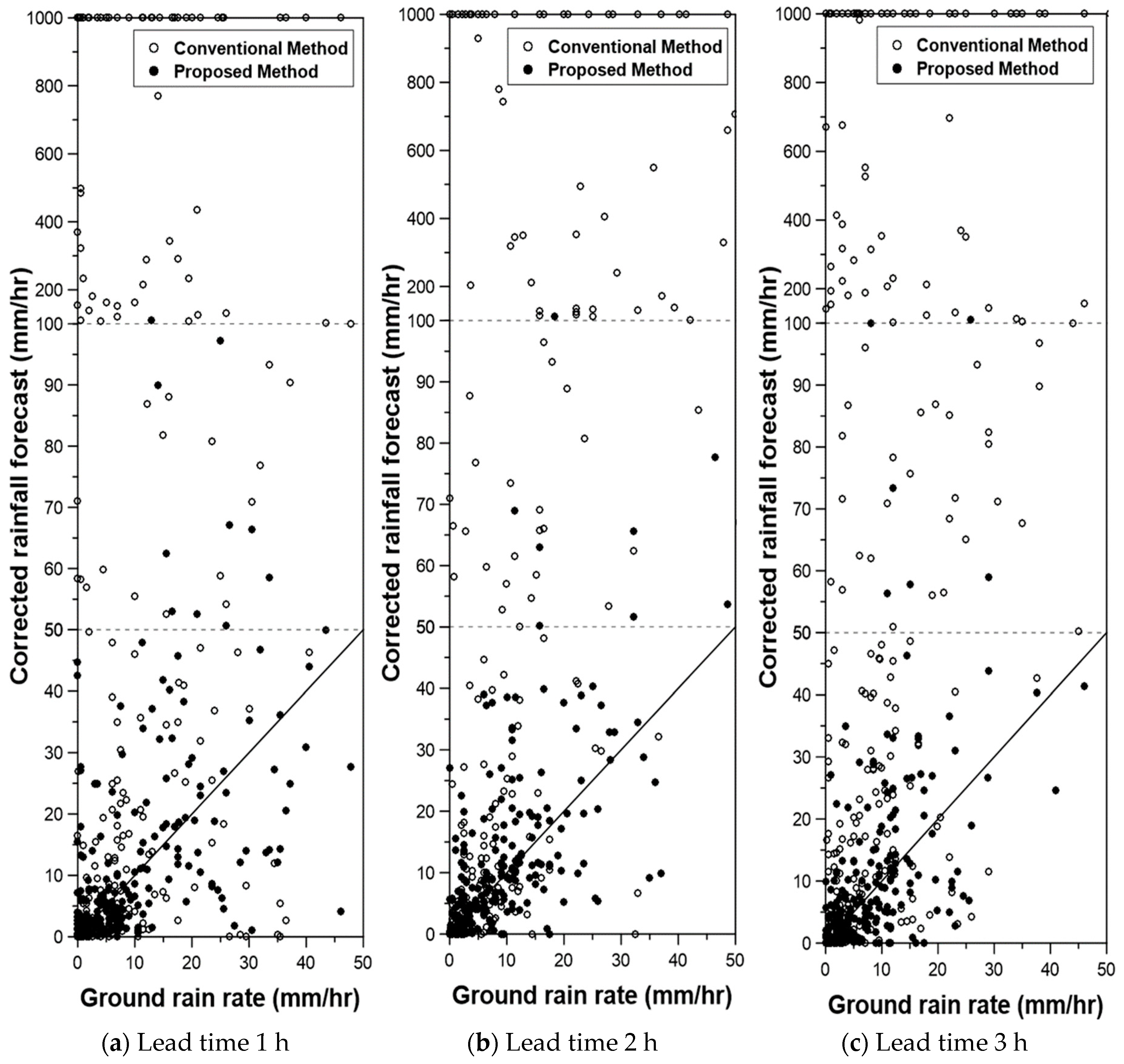
4.2. Overall Results
5. Conclusions
Author Contributions
Funding
Conflicts of Interest
References
- Sweeney, T.L. Modernized Areal Flash Flood Guidance; NOAA: Silver Spring, MD, USA, 1992.
- Georgakakos, K.P. On the design of national, real-time warning systems with capability for site-specific, flash-flood forecasts. Bull. Am. Meteorol. Soc. 1986, 67, 1233–1239. [Google Scholar] [CrossRef]
- Ahn, W. A study on the estimation of flash flood index. J. Industitute Ind. Technol. 2000, 15, 11–19. [Google Scholar]
- Bae, D.; Kim, J. Development of Korea flash flood guidance system: (I) Theory and system design. J. Korean Soc. Civ. Eng. 2007, 27, 237–243. [Google Scholar]
- Yoo, C.; Yoon, J.; Ha, E. Sampling error of areal average rainfall due to radar partial coverage. Stoch. Environ. Res. Risk Assess. 2010, 24, 1097–1111. [Google Scholar] [CrossRef]
- Sweeney, T.L.; Fread, D.L.; Georgakakos, K.P. GIS Application for NWS Flash Flood Guidance Model; USGS, WRI: Springfiled, VA, USA, 1993.
- Carpenter, T.M.; Sperfslage, J.A.; Georgakakos, K.P.; Sweeney, T.; Fread, D.L. National threshold runoff estimation utilizing GIS in support of operational flash flood warning systems. J. Hydrol. 1999, 224, 21–44. [Google Scholar] [CrossRef]
- Bhaskar, N.R.; French, M.N.; Kyiamah, G.K. Characterization of Flash Floods in Eastern Kentucky. J. Hydrol. Eng. 2000, 5, 327–331. [Google Scholar] [CrossRef]
- Mukhopadhyay, B.; Cornelius, J.; Zehner, W. Application of kinematic wave theory for predicting flash flood hazards on coupled alluvial fan-piedmont plain landforms. Hydrol. Process. 2003, 17, 839–868. [Google Scholar] [CrossRef]
- Ogden, F.L.; Sharif, H.O.; Senarath, S.U.S.; Smith, J.A.; Baeck, M.L.; Richardson, J.R. Hydrologic analysis of the Fort Collins, Colorado, flash flood of 1997. J. Hydrol. 2000, 228, 82–100. [Google Scholar] [CrossRef]
- Borga, M.; Boscolo, P.; Zanon, F.; Sangati, M. Hydrometeorological analysis of the 29 August 2003 flash flood in the Eastern Italian Alps. J. Hydrometeorol. 2007, 8, 1049–1067. [Google Scholar] [CrossRef]
- Nikolopoulos, E.I.; Anagnostou, E.N.; Borga, M.; Vivoni, E.R.; Papadopoulos, A. Sensitivity of a mountain basin flash flood to initial wetness condition and rainfall variability. J. Hydrol. 2011, 402, 165–178. [Google Scholar] [CrossRef]
- Ruiz-Villanueva, V.; Diez-Herrero, A.; Stoffel, M.; Bollschweiler, M.; Bodoque, J.M.; Ballesteros, J.A. Dendrogeomorphic analysis of flash floods in a small ungauged mountain catchment (Central Spain). Geomorphology 2010, 118, 383–392. [Google Scholar] [CrossRef]
- Shin, H.; Kim, H.; Park, M. The study of the fitness on calculation of the flood warning trigger rainfall using GIS and GCUH. J. Korea Water Resour. Assoc. 2004, 37, 407–424. [Google Scholar] [CrossRef]
- Mueller, C.; Saxen, T.; Roberts, R.; Wilson, J.; Betancourt, T.; Dettling, S.; Oien, N.; Yee, J. NCAR Auto-Nowcast System. Weather Forecast 2003, 18, 545–561. [Google Scholar] [CrossRef]
- Dixon, M.; Wiener, G. Titan—Thunderstorm Identification, Tracking, Analysis, and Nowcasting—A Radar-Based Methodology. J. Atmos. Ocean Technol. 1993, 10, 785–797. [Google Scholar] [CrossRef]
- Saito, K.; Fujita, T.; Yamada, Y.; Ishida, J.I.; Kumagai, Y.; Aranami, K.; Ohmori, S.; Nagasawa, R.; Kumagai, S.; Muroi, C.; et al. The operational JMA nonhydrostatic mesoscale model. Mon. Weather Rev. 2006, 134, 1266–1298. [Google Scholar] [CrossRef]
- Teradar, M. The development of short-term rainfall prediction system in mountainous region by the combination of extrapolation model and meso-scale atmospheric model. In Proceedings of the 6th International Symposium on Hydrolojical Applications of Weather Radar, Melbourne, Australia, 2–4 February 2004. [Google Scholar]
- Bellon, A.; Austin, G.L. Evaluation of 2 Years of Real-Time Operation of a Short-Term Precipitation Forecasting Procedure (Sharp). J. Appl. Meteorol. 1978, 17, 1778–1787. [Google Scholar] [CrossRef]
- Germann, U.; Zawadzki, I. Scale-dependence of the predictability of precipitation from continental radar images. Part I: Description of the methodology. Mon. Weather Rev. 2002, 130, 2859–2873. [Google Scholar] [CrossRef]
- Germann, U.; Zawadzki, I.; Turner, B. Predictability of precipitation from continental radar images. Part IV: Limits to prediction. J. Atmos. Sci. 2006, 63, 2092–2108. [Google Scholar] [CrossRef]
- Radhakrishna, B.; Zawadzki, I.; Fabry, F. Predictability of Precipitation from Continental Radar Images. Part V: Growth and Decay. J. Atmos. Sci. 2012, 69, 3336–3349. [Google Scholar] [CrossRef]
- Turner, B.J.; Zawadzki, I.; Germann, U. Predictability of precipitation from continental radar images. Part III: Operational nowcasting implementation (MAPLE). J. Appl. Meteorol. 2004, 43, 231–248. [Google Scholar] [CrossRef]
- Korea Meteorological Administration (KMA). Study on the Weather Radar Application (II); KMA: Seoul, Korea, 2008.
- Atencia, A.; Zawadzki, I.; Berenguer, M. Scale Characterization and Correction of Diurnal Cycle Errors in MAPLE. J. Appl. Meteorol. Clim. 2017, 56, 2561–2575. [Google Scholar] [CrossRef]
- Munoz, C.; Wang, L.P.; Willems, P. Enhanced object-based tracking algorithm for convective rain storms and cells. Atmos. Res. 2018, 201, 144–158. [Google Scholar] [CrossRef]
- Novo, S.; Martinez, D.; Puentes, O. Tracking, analysis and nowcasting of Cuban convective cells as seen by radar. Meteorol. Appl. 2014, 21, 585–595. [Google Scholar] [CrossRef]
- Yang, L.; Smith, J.A.; Baeck, M.L.; Bou-Zeid, E.; Jessup, S.M.; Tian, F.Q.; Hu, H.P. Impact of Urbanization on Heavy Convective Precipitation under Strong Large-Scale Forcing: A Case Study over the Milwaukee-Lake Michigan Region. J. Hydrometeorol. 2014, 15, 261–278. [Google Scholar] [CrossRef]
- Shah, S.; Notarpietro, R.; Branca, M. Storm Identification, Tracking and Forecasting Using High-Resolution Images of Short-Range X-Band Radar. Atmosphere 2015, 6, 579–606. [Google Scholar] [CrossRef]
- Hubbert, J.C.; Dixon, M.; Ellis, S.M. Weather Radar Ground Clutter. Part II: Real-Time Identification and Filtering. J. Atmos. Ocean Technol. 2009, 26, 1181–1197. [Google Scholar] [CrossRef]
- Hubbert, J.C.; Dixon, M.; Ellis, S.M.; Meymaris, G. Weather Radar Ground Clutter. Part I: Identification, Modeling, and Simulation. J. Atmos. Ocean Technol. 2009, 26, 1165–1180. [Google Scholar] [CrossRef]
- Islam, T.; Rico-Ramirez, M.A.; Han, D.W.; Srivastava, P.K. Artificial intelligence techniques for clutter identification with polarimetric radar signatures. Atmos. Res. 2012, 109, 95–113. [Google Scholar] [CrossRef]
- Yoo, C.; Yoon, J. The error structure of the CAPPI and the correction of the range dependent error due to the earth curvature. Atmosphere 2012, 22, 309–319. [Google Scholar] [CrossRef]
- Austin, P.M. Relation between Measured Radar Reflectivity and Surface Rainfall. Mon. Weather Rev. 1987, 115, 1053–1071. [Google Scholar] [CrossRef]
- Collier, C.G. Accuracy of Rainfall Estimates by Radar. 1. Calibration by Telemetering Rain-Gages. J. Hydrol. 1986, 83, 207–223. [Google Scholar] [CrossRef]
- National Disaster Management Research Institute (NDMI). Advancement of Mountain Flash Flood Prediction System & Development of Decision-Making Supporting System; NDMI: Seoul, Korea, 2010.
- Germann, U.; Zawadzki, I. Scale dependence of the predictability of precipitation from continental radar images. Part II: Probability forecasts. J. Appl. Meteorol. 2004, 43, 74–89. [Google Scholar] [CrossRef]
- Huff, F.A. Time Distribution of Rainfall in Heavy Storms. Water Resour. Res. 1967, 3, 1007–1019. [Google Scholar] [CrossRef]
- Clayton, A.J.; Deacon, R.C. The Investigation of Local Patterns of Precipitation and Storm Movement Using Computer Techniques; Department of Civil Engineering, Bristol University: Bristol, UK, 1971. [Google Scholar]
- Marshall, R.J. The Estimation and Distribution of Storm Movement and Storm Structure, Using a Correlation-Analysis Technique and Rain-Gauge Data. J. Hydrol. 1980, 48, 19–39. [Google Scholar] [CrossRef]
- Niemczynowicz, J. Storm Tracking Using Rain-Gauge Data. J. Hydrol. 1987, 93, 135–152. [Google Scholar] [CrossRef]
- Wilson, J.W. Integration of radar and raingage data for improved rainfall measurement. J. Appl. Meteorol. 1970, 9, 489–497. [Google Scholar] [CrossRef]
- Leese, J.A.; Charles, S.N.; Bruce, B.C. An automated technique for obtaining cloud motion from geosynchronous satellite data using cross correlation. J. Appl. Meteorol. 1971, 10, 118–132. [Google Scholar] [CrossRef]
- Austin, G.L.; Bellon, A. The use of digital weather radar records for short-term precipitation forecasting. Q. J. R. Meteorol. Soc. 1974, 100, 658–664. [Google Scholar] [CrossRef]
- Rinehart, R.E.; Garvey, E.T. 3-Dimensional Storm Motion Detection by Conventional Weather Radar. Nature 1978, 273, 287–289. [Google Scholar] [CrossRef]
- Hilst, G.R.; Russo, J.A. An Objective Extrapolation Technique for Semi-Conservative Fields with an Application to Radar Patterns; Travelers Insurance Companies: Hartford, CT, USA, 1960. [Google Scholar]
- Kim, G.; Kim, J.P. Development of a short-term rainfall forecasting model using weather radar data. J. Korea Water Resour. Assoc. 2008, 41, 1023–1034. [Google Scholar] [CrossRef]
- Brandes, E.A. Optimizing Rainfall Estimates with Aid of Radar. J. Appl. Meteorol. 1975, 14, 1339–1345. [Google Scholar] [CrossRef]
- Lin, D.S. An Application of Recursive Methods to Radar-Rainfall Estimation. Master’s Thesis, University of Iowa, Iowa City, IA, USA, 1989. [Google Scholar]
- Anagnostou, E.N.; Krajewski, W.F. Real-time radar rainfall estimation. Part I: Algorithm formulation. J. Atmos. Ocean Technol. 1999, 16, 189–197. [Google Scholar] [CrossRef]
- Anagnostou, E.N.; Krajewski, W.F.; Seo, D.J.; Johnson, E.R. Mean-Field Rainfall Bias Studies for Wsr-88d. J. Hydrol. Eng. 1998, 3, 149–159. [Google Scholar] [CrossRef]
- Yoo, C.; Kim, J.; Jung, J.; Yang, D. Mean field bias correction of the very-short-range-forecast rainfall using the kalman filter. J. Korean Soc. Hazard Mitig. 2011, 11, 17–28. [Google Scholar] [CrossRef]
- Lee, J.; Yoon, J.; Jeon, H. Evaluation for the correction of radar rainfall due to the spatial distribution of raingauge network. J. Korean Soc. Hazard Mitig. 2014, 14, 337–345. [Google Scholar] [CrossRef]
- Yoo, C.; Park, C.; Yoon, J. Decision or G/R ratio for the correction of mean-field bias of radar rainfall and linear regression problem. J. Korean Soc. Civ. Eng. 2011, 31, 393–403. [Google Scholar]


| Event | Duration (h) | Maximum Rainfall Intensity (mm/h) | Most Severely Affected Area | Moving Direction |
|---|---|---|---|---|
| 1 | 04:00 4 July–03:00 5 July (24) | 34.5 | Central |  (NE) (NE) |
| 2 | 05:00 5 July–03:00 6 July (23) | 57.1 | Eastern |  (SE) (SE) |
| 3 | 21:00 2 October–15:00 3 October (20) | 18.3 | Northern | (SE) |
| 4 | 23:00 4 October–14:00 5 October (17) | 98.3 | Southern | (NE) |
| Storm Event | Lead Time | ||
|---|---|---|---|
| 1 h | 2 h | 3 h | |
| 4–5 July | 0.630 (0.116) | 0.656 (0.075) | 0.601 (0.054) |
| 5–6 July | 0.617 (0.095) | 0.645 (0.101) | 0.558 (0.051) |
| 2–3 October | 0.678 (0.075) | 0.623 (0.102) | 0.594 (0.129) |
| 4–5 October | 0.600 (0.128) | 0.524 (0.132) | 0.566 (0.133) |
| Average | 0.633 (0.107) | 0.620 (0.112) | 0.584 (0.103) |
| Storm Event | Lead Time | |||||
|---|---|---|---|---|---|---|
| 1 h | 2 h | 3 h | ||||
| Conventional | Proposed | Conventional | Proposed | Conventional | Proposed | |
| 4–5 July | 7.937 (22.381) | 1.736 (1.402) | 11.853 (16.678) | 1.227 (0.983) | 11.420 (25.323) | 1.145 (1.674) |
| 5–6 July | 12.385 (22.163) | 1.716 (1.200) | 21.362 (27.607) | 2.059 (1.589) | 23.392 (37.820) | 0.791 (0.471) |
| 2–3 October | 2.081 (5.008) | 0.955 (1.341) | 1.197 (3.513) | 0.476 (0.452) | 1.665 (2.565) | 0.239 (0.212) |
| 4–5 October | 2.277 (2.585) | 1.069 (0.683) | 5.612 (5.557) | 1.295 (1.250) | 5.447 (6.496) | 0.894 (0.637) |
| All | 6.798 (17.628) | 1.450 (1.285) | 8.786 (15.506) | 1.265 (1.228) | 8.453 (20.859) | 0.812 (1.154) |
© 2018 by the authors. Licensee MDPI, Basel, Switzerland. This article is an open access article distributed under the terms and conditions of the Creative Commons Attribution (CC BY) license (http://creativecommons.org/licenses/by/4.0/).
Share and Cite
Na, W.; Yoo, C. A Bias Correction Method for Rainfall Forecasts Using Backward Storm Tracking. Water 2018, 10, 1728. https://doi.org/10.3390/w10121728
Na W, Yoo C. A Bias Correction Method for Rainfall Forecasts Using Backward Storm Tracking. Water. 2018; 10(12):1728. https://doi.org/10.3390/w10121728
Chicago/Turabian StyleNa, Wooyoung, and Chulsang Yoo. 2018. "A Bias Correction Method for Rainfall Forecasts Using Backward Storm Tracking" Water 10, no. 12: 1728. https://doi.org/10.3390/w10121728
APA StyleNa, W., & Yoo, C. (2018). A Bias Correction Method for Rainfall Forecasts Using Backward Storm Tracking. Water, 10(12), 1728. https://doi.org/10.3390/w10121728