Article

Impact of the Sea Effect on Sudden Fog on the Western Coast of the Bohai Sea: A Case Study

1
Tianjin Key Laboratory for Oceanic Meteorology, Tianjin 300074, China
2
Tianjin Institute of Meteorological Sciences, Tianjin 300074, China
3
Meteorological Service in Binhai New Area of Tianjin, Tianjin 300350, China
4
Tianjin Meteorological Information Center, Tianjin 300074, China
*
Authors to whom correspondence should be addressed.
Atmosphere 2024, 15(3), 326; https://doi.org/10.3390/atmos15030326
Submission received: 19 January 2024 / Revised: 19 February 2024 / Accepted: 28 February 2024 / Published: 5 March 2024
(This article belongs to the Section Meteorology)

Abstract

:
The term “sea effect” generally refers to the process of air mass modification after cold air flows above a warm sea surface. Affected by the sea effect, small-scale and sudden fogs have occasionally been observed on the western coast of the Bohai Sea. A more in-depth study of this type of fog is crucial for ensuring the safety of maritime and aerial traffic routes in this region. This study investigated the formation mechanism of this specific type of fog on the morning of 17 October 2007, utilizing both meteorological stations and 255 m tower observations, combined with the results of the Weather Research and Forecasting model (WRF). It is demonstrated that Bohai Sea evaporation and the associated water vapor advection played crucial roles in the formation of fog along the west coast of the Bohai Sea. The cold return flow became more moist as it passed over the warm Bohai Sea, which was the primary contributor to triggering regional fog on the western coast. A moisture budget analysis revealed that water vapor from the Bohai Sea intruded into its western coast along an eastward trajectory, dominating the oscillations in the net moisture flux. The eastern water vapor flux significantly increased at 17:00 on the 16th (Local time, LST), reaching its peak at 21:00. Correspondingly, the fog water growth rate began to increase at 23:00 on the 16th, reaching its maximum at 03:00 on the 17th. A sensitivity experiment on evaporation further indicated that the Bohai sea effect played a decisive role in fog formation. With a tenfold reduction in evaporation from the Bohai Sea and subsequent significant weakening of water vapor advection, the simulated fog along the western coast of the Bohai Sea completely disappeared. Understanding the formation mechanism of this type of fog is beneficial for refining forecasting focal points, thereby enhancing forecast accuracy in a targeted manner.

1. Introduction

The Bohai Sea, located in the eastern part of North China, is an important bay providing a critical defensive perimeter to safeguard national security. Key cities along the Bohai Sea coastline, including those within the Jing-Jin-Ji metropolitan region, possess paramount geopolitical and economic strategic significance. Various weather phenomena along the coast are associated with the dynamic and thermal conditions of the Bohai Sea. Airflows over the Bohai Sea often undergo transformation due to the influence of the marine underlying surface, resulting in weather phenomena such as snowstorms and rain [1,2], defined as the Bohai sea effect [3]. The Bohai sea effect generally refers to the exchange of turbulence, heat, and moisture between the water body and the lower atmosphere when air flows over the Bohai Sea’s surface. However, there have been few studies investigating the impact of the Bohai sea effect on fog formation.
As is widely acknowledged, atmospheric flows originating from the ocean play a crucial role in the formation and development of coastal fog. Suitable wind speed and direction are essential factors in transporting warm and moist air towards coastal cold surfaces, constituting one of the key conditions for the occurrence of coastal fog [4,5,6]. For coastal fog over the Yellow Sea, the strong summer monsoon in July transports a significant amount of warm and moist air, providing the material basis for the formation of fog over the Yellow Sea [7]. An enhancement in the intensity of the summer monsoon results in more foggy days, while a weaker monsoon leads to fewer foggy days. Backward trajectory analysis by Huang et al. [8] also indicates that the most critical physical processes influencing the occurrence of spring fog in the northern Yellow Sea are moisture advection and humidity distribution, with warm fog occurrence rates reaching 55% and 70% along the eastern and southeastern maritime pathways. For coastal fog in South China, warm and moist air flowing from the southeast enters the coastal areas of Guangdong, providing stable inversion layers and abundant moisture conditions for the generation and maturation of dense fog along the coast [9].
The western coast of the Bohai Sea represents a typical “C”-shaped coastal zone. The unique geographical environment results in frequent occurrences of dense fog, which are often associated with easterly winds passing over the Bohai Sea [10]. Ye et al. [11] categorized the weather patterns in North China into nine classes using T-type rotated principal component analysis (T-PCA). When the western coast is under the influence of east wind flow (NEH type), the probability of low atmospheric horizontal visibility less than 10 km is 48.3%, while under the control of northeast wind flow (NH type), the probability of low visibility is 36.7%. Notably, these two easterly winds have the highest humidity among all flow types, with an average relative humidity of 68.4% for the NEH type and 69.6% for the NH type, suggesting a close association between high humidity eastward flows and frequent dense fog on the western coast. Zheng et al. [12] further pointed out that weather situations dominated by isobaric fields (24.1%) and inverted trough cold front types (24.1%) are prevalent in the formation of fog on the western coast of the Bohai Sea, especially when an inverted trough cold front is accompanied by a northeast cyclone, and the western coast is under the control of east wind. Building on this understanding, Wu et al. [13] conducted an analysis of a sudden morning fog event on the western coast of the Bohai Sea against the background of eastern cold air return flow, revealing that this flow passing through the Bohai Sea rapidly moistens the initially dry lower atmosphere on the western coast in the morning. This study highlights the humidification effect of the Bohai Sea’s surface on the formation of dense fog from an observational perspective.
Despite previous statistical analyses and case studies confirming the propensity for dense fog occurrence along the western coast of the Bohai Sea against the background of cold return flow in Northeast China, there has been limited exploration of the intrinsic connection between the Bohai sea effect and dense fog along the western coast. Furthermore, a quantitative analysis of the sea effect on water vapor condensation along the western coast has not been conducted.
Numerical simulations have been widely used in studies on the mechanisms of fog [14,15,16,17,18,19,20]. On 17 October 2007, a fog event influenced by the sea effect occurred in the western coastal zone of the Bohai Sea and was simulated using the WRF model. The simulated fog distribution, intensity, and temporal variation were highly consistent with observations. Utilizing the simulation results, we investigated the intrinsic connection between the Bohai sea effect and dense fog on the western coast, as well as quantifying the contributions of the humidification effect of sea evaporation and the associated heat and moisture advection to the fog processes guided by return flow.

2. Data and Methods

2.1. Observation Data

(1)
Six-hour interval visibility data from manual observations of National Meteorological Information Center of China (http://data.cma.cn, accessed on 1 June 2023) are used to determine the fog area. When atmospheric visibility is less than 1 km, it is classified as fog.
(2)
Hourly surface observations from automatic meteorological stations were available from the National Meteorological Information Center of China (http://data.cma.cn, accessed on 1 June 2023). These data, which include conventional meteorological observations such as wind, temperature, pressure, humidity, and others, were employed for weather analysis and verification of simulated fog areas.
(3)
Ten-minute observations of wind, temperature, humidity, and visibility at 15 vertical levels from the Tianjin atmospheric boundary layer observation station (39.04° N, 117.12° E) were obtained (http://tj.cma.gov.cn/, accessed on 1 July 2023). The vertical levels were located at heights of 5, 10, 20, 30, 40, 60, 80, 100, 120, 140, 160, 180, 200, 220 and 250 m. Data underwent quality control measures, including logical extreme checks, temporal consistency checks, and spatial consistency checks. The specific location of the tower is depicted in Figure 1. These observations were used to provide actual conditions of visibility and wind vector at various altitudes.

2.2. Model Configuration and Experimental Design

WRF version 4.0.1 was employed as the numerical model core. The simulation started at 08:00 on 16 October 2007 (Local Time, LST), and the simulation duration was 48 h, with a time step of 30 s. The initial and lateral boundary conditions were provided by the National Centers for Environmental Prediction (NCEP) Final 1° × 1° data (https://rda.ucar.edu/datasets/ds083.2/index.html, accessed on 30 July 2023). The simulation domain, as illustrated in Figure 1, had a central point at (40° N, 120° E) and a grid resolution of 5 km (441 × 369 grid points). To better capture the shallow eastward flow in the boundary layer, the vertical layers were set to 53, with 23 layers below 1 km (η = 1.000, 0.997, 0.994, 0.991, 0.988, 0.985, 0.982, 0.979, 0.976, 0.973, 0.970, 0.967, 0.964, 0.9602, 0.9564, 0.9526, 0.9488, 0.945, 0.9412, 0.9265, 0.9118, 0.8971, 0.8824). The lowest model layer was situated at a height of approximately 10 m. The physics parameterization schemes used were as follows: the Yousei University (YSU) boundary layer scheme [21], the Rapid Radiative Transfer Model for General Circulation Models (RRTMG) longwave and shortwave radiation parameterization scheme [22], the 5-layer thermal diffusion land surface process scheme [23], and the WRF Single-Moment 6-Class Microphysics (WSM6) cloud microphysics parameterization scheme [24]. Due to a sufficiently high resolution, the cumulus convection parameterization scheme was disabled [25,26]. The fog top turbulent diffusion module (ysu_topdown_pblmix = 1) was activated exclusively for fog simulation [27].

3. Fog event and Model Assessment

3.1. Overview of the Fog Event

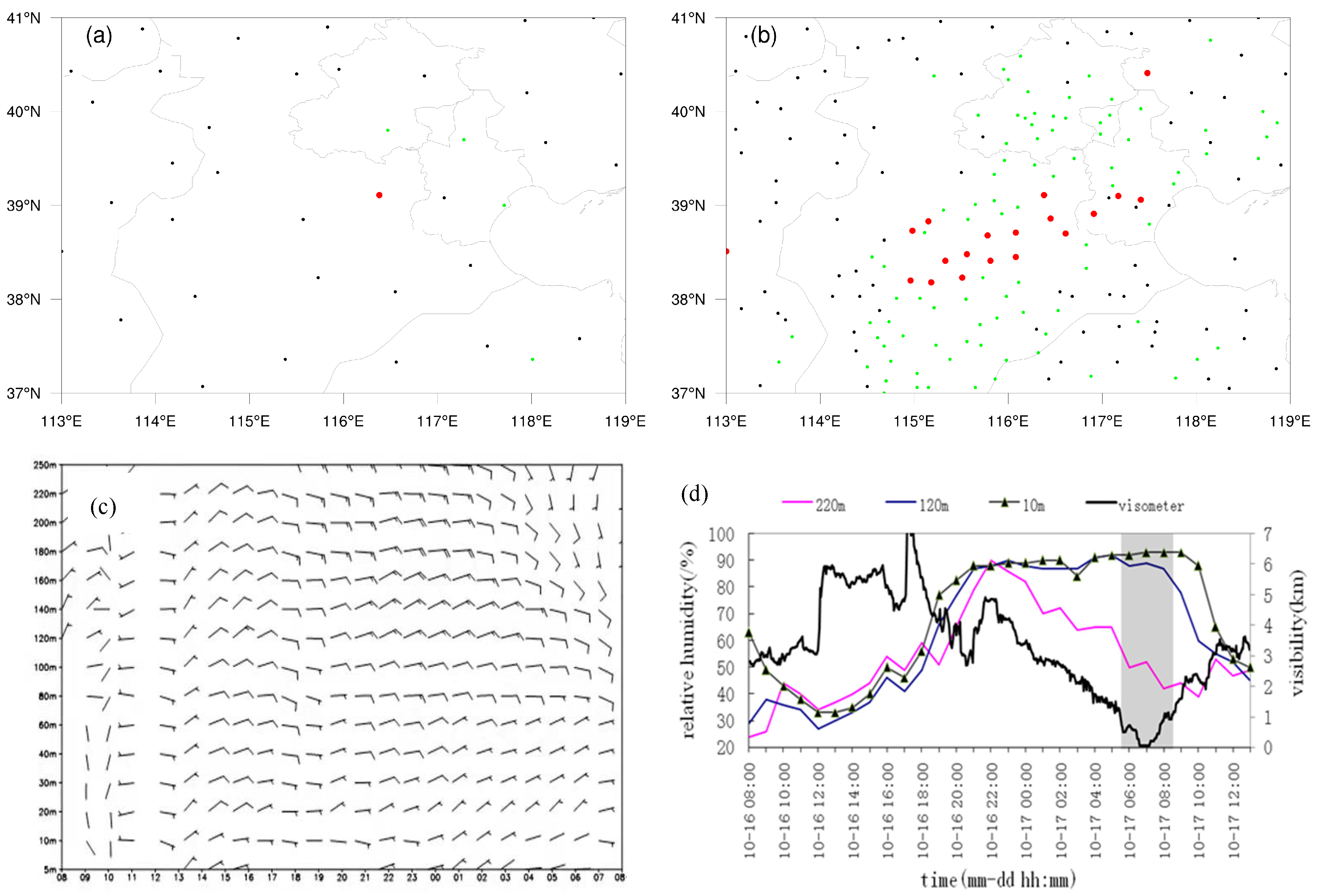
After nightfall on 16 October 2007, visibility along the western coast of the Bohai Sea steadily decreased. Light fog initially appeared sporadically in the Beijing–Tianjin region at 02:00 on the 17th (Figure 2a). By 08:00, the fog area had continuously extended westward to the central and southern regions of Hebei, forming an east-west-oriented band approximately 300 km in length and 50 km in width (Figure 2b). The inland penetration of the fog belt was closely aligned with the direction of the eastward wind (Figure 2c). Under the effect of eastward winds, the relative humidity at heights of 220 m, 120 m, and 10 m from the Tianjin atmospheric boundary layer observation station rapidly increased from 40% to 90% between 18:00 and 22:00 on the 16th (Figure 2d). After 22:00, the relative humidity at 220 m started to decline, while the relative humidity at 120 m and 10 m remained stable with an increasing trend. Meanwhile, visibility at the surface continued to decrease. By 06:00 on the 17th, the relative humidity at 2 m reached 92%, and visibility dropped to less than 1 km, indicating the formation of dense fog (Figure 2d, gray shaded area). Visibility continued to decrease, reaching less than 100 m around 07:00. The dense fog dissipated around 8:40. It was observed that, accompanied by eastward wind, the fog event exhibited characteristics of short duration and bursting.

3.2. Weather Background

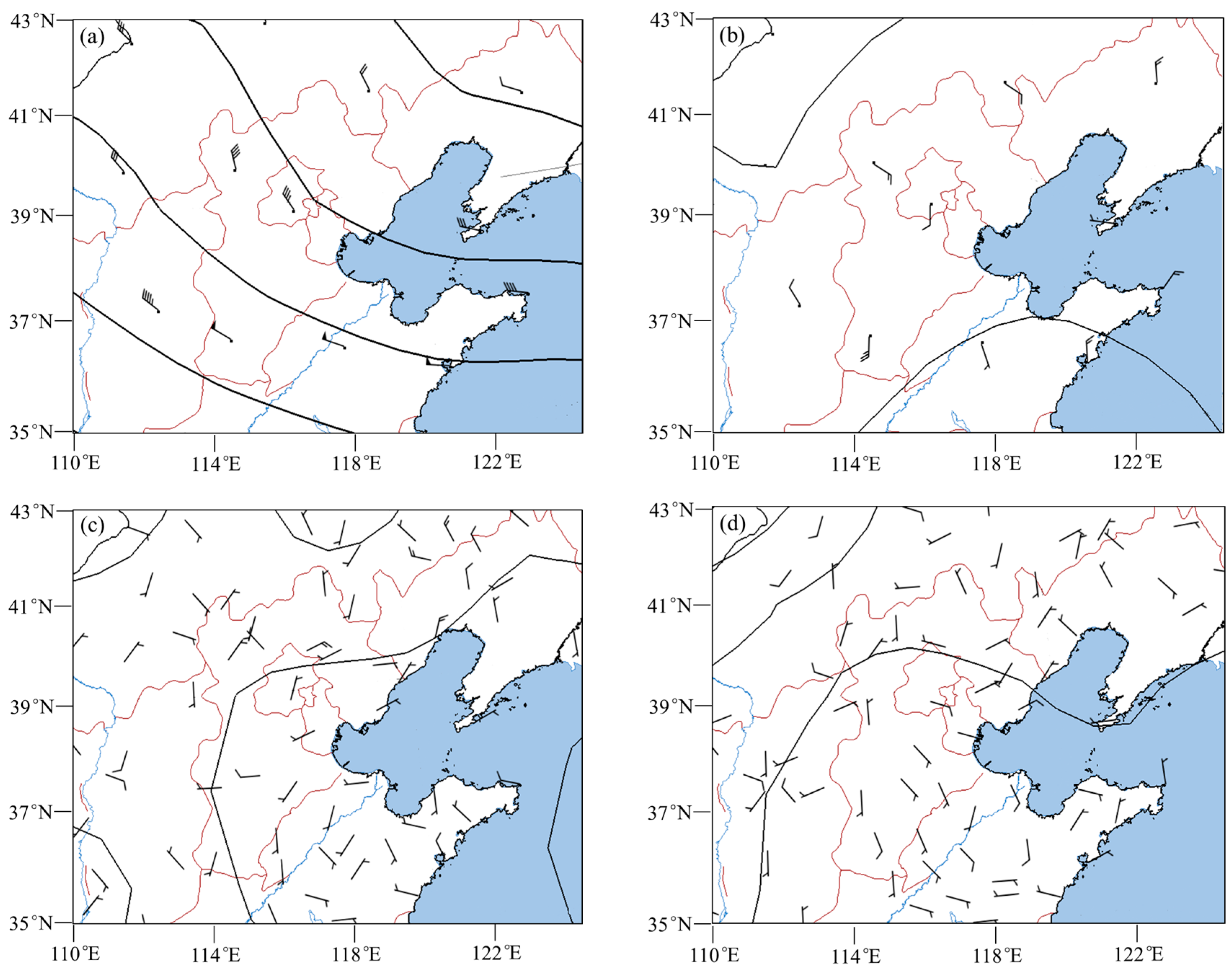
It was observed from the 500 hPa pressure field that northwest airflow separated from the bottom of the polar vortex in North China from 15 to 16 October 2007 (Figure 3a). In the lower pressure field (Figure 3b), a small branch of cold air split from the Lake Baikal region and moved towards Northeast China. This split air, hindered by the topography of the Changbai Mountains, flowed over the plain of Northeast China to the south at 925 hPa and near the surface (Figure 3c). It then circled over the Bohai Sea and returned to the North China Plain, forming a typical northeast return flow weather pattern (Figure 3d). Due to the control of a high-pressure ridge aloft, there was no significant precipitation or snow. By 05:00 to 08:00 on 17 October, as the high-pressure system moved eastward over the sea and a low-pressure system entered the western part of Northeast China, North China was in a weak pressure field between the two systems. The weather was clear, facilitating radiative cooling at night.

3.3. The Model Evaluation of the Fog Process

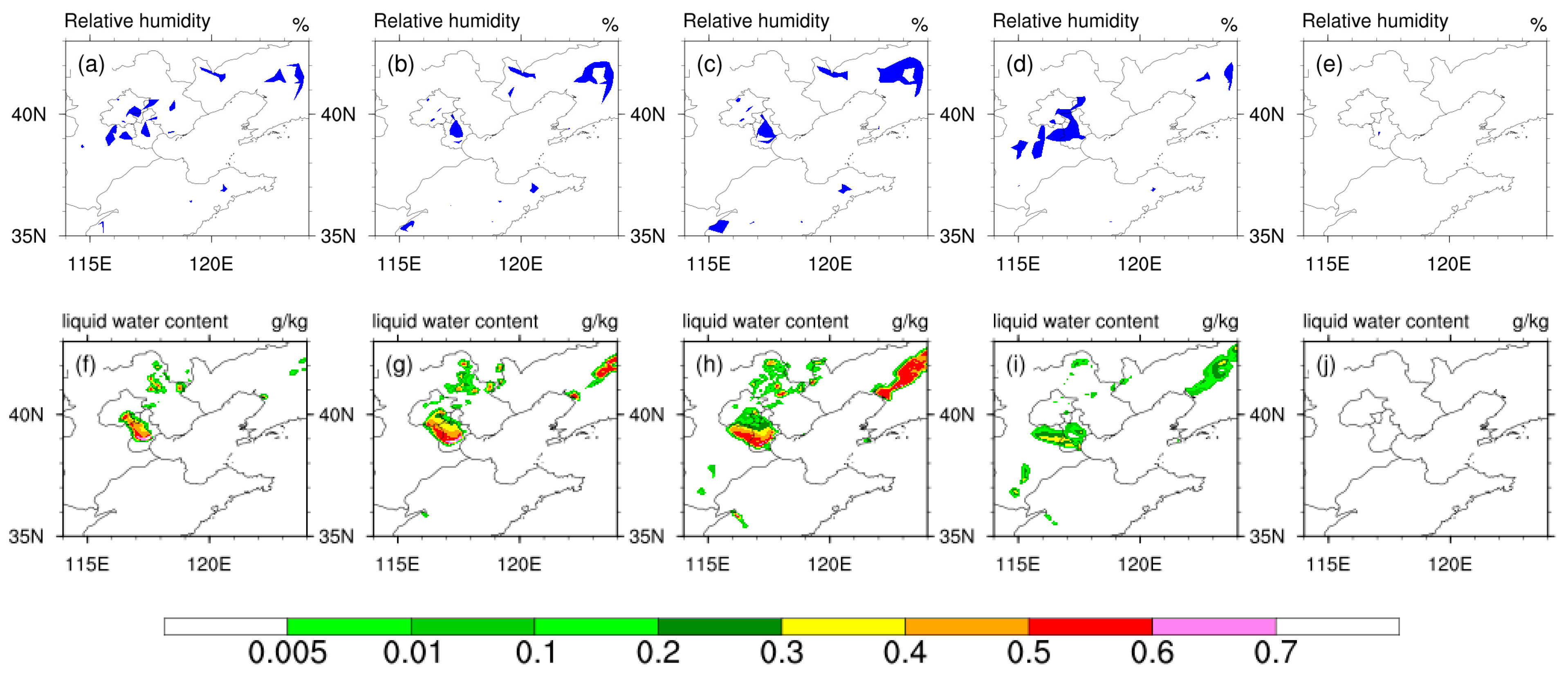
Figure 4 illustrates the temporal evolution of observed (Figure 4a–e) and simulated (Figure 4f–j) fog areas. We have included Figure 2a,b to clarify the fog area using manual visibility observations data. However, the manual observations of visibility are only available at six-hour intervals. The automatic observations of wind, temperature, and humidity are collected hourly, but certain stations lack observation values of weather phenomena and visibility. To characterize the short duration of fog changes, this section employed the area represented by sites with relative humidity greater than 95% among the 367 sites to represent fog areas [28,29]. The fog area distribution from visibility by the China Meteorological Administration in Figure 2a,b was consistent with the relative humidity (>95%) zone shown in Figure 4a–e.
Upon comparison, it was noted that this fog process displayed small- to medium-scale features, characterized by small scale, strong suddenness, and short duration. Despite minor discrepancies, the simulated fog area and onset time along the western coast of the Bohai Sea were consistent with the observations. Especially under the influence of the eastward wind, the simulated westward extension of the fog band showed a good correspondence with the observations.
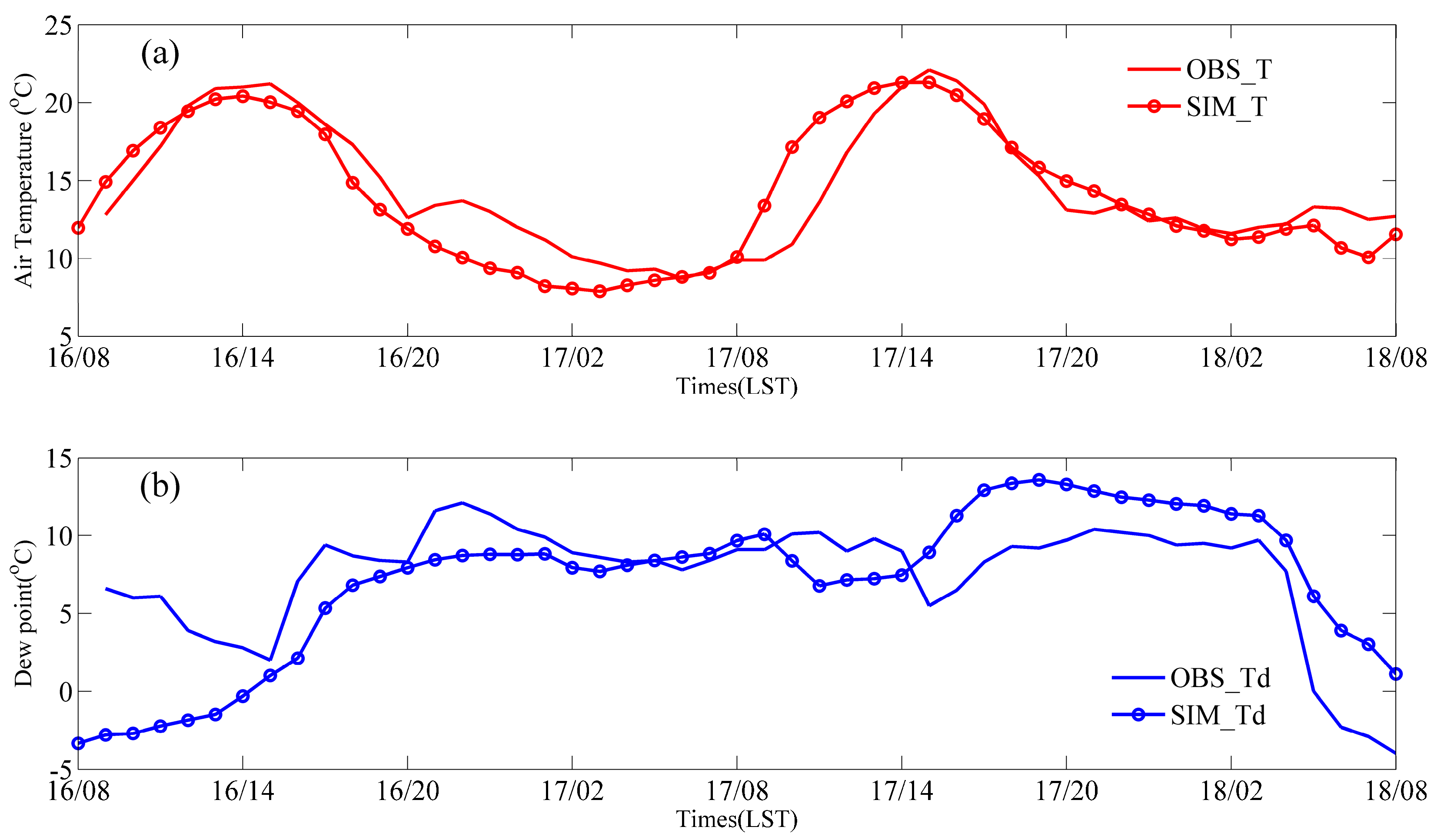
As the formation of dense fog is closely related to near-surface temperature and humidity, we also evaluated the simulation performance of 2 m temperature and dew point temperature at the Tianjin site (Figure 5). The diurnal variation in simulated temperature and humidity closely matched the observations. While there was a noticeable deviation in simulated dew point temperature during the initial stages compared to observations, the positive temperature bias and negative dew point temperature bias did not exceed 1 °C during the formation and development stages of dense fog.

4. Impact of Low-Level Easterly Winds on Dense Fog along the Western Coast of the Bohai Sea

4.1. Water Vapor and Temperature Advection

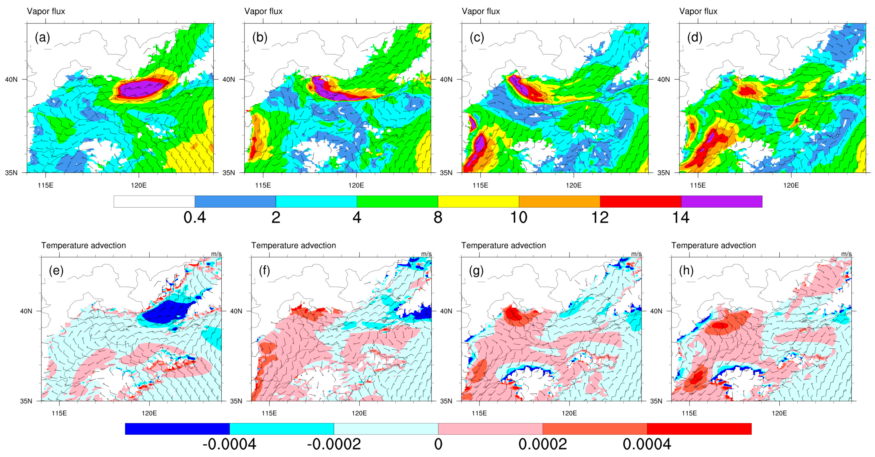
Figure 6 illustrates the simulated water vapor and temperature advection guided by return flow at a height of 1000 hPa. At 09:00 on the 16th, cold air flowed from the northeast plain with a wind speed of 10 m/s, passing over the Bohai Sea and then turning eastward towards the western coast, accompanied by a water vapor advection exceeding 14 g/(cm·s·hPa) (Figure 6a) and a cold advection with an intensity reaching −4 × 10⁻⁴ °C/s (Figure 6e). As time progressed, the cold advection gradually weakened (Figure 6f) and transitioned to weak warm advection over the western Bohai Sea (Figure 6g,h). Strong eastward water vapor advection persisted both before (22:00 on the 16th, Figure 6b) and during the fog event (02:00 on the 17th, Figure 6c). The moisture advection belt extended approximately 550 km in length and 110 km in width, spanning the northern part of the Bohai Sea and gradually intruding into the western coast of the Bohai Sea. Due to the long radiation cooling of the nighttime land surface, which acted as a cold underlying layer, the warm and moist advection cooled and descended gradually, facilitating the formation of dense fog (Figure 4f). The land fog belt (Figure 4f) corresponded well with the intrusion of the moist advection into the western coast (Figure 6c). At 06:00 on the 17th, the wind speed of return flow decreased to 6 m/s, and the moisture advection weakened accordingly (Figure 6d). Meanwhile, a southwest airflow strengthened in the southern part of Hebei and gradually moved northward. In the south of Tianjin, it turned into a southeast airflow, leading to convergence with the weakened northeast return flow (Figure 6d). This convergence, coupled with enhanced turbulence due to the lifting of the fog top, resulted in a reduction in liquid water content (LWC) at the surface (Figure 4i). With the weakening of the eastward wind transport and the strengthening of the short radiation during the daytime, the dense fog naturally dissipated.
Figure 7 presents simulated profiles of specific humidity, temperature, and wind speed at the Tianjin station. This analysis aims to examine the impact of sustained water vapor and temperature advection on the boundary layer structure along the western coast of the Bohai Sea. It can be noted that at 09:00 on the 16th, the near-surface specific humidity was only 3 g/kg (Figure 7a), with a temperature close to 18 °C (Figure 7b), and the surface wind speed was relatively low, with the entire boundary layer wind speed not exceeding 3 m/s (Figure 7c). With continuous eastward moisture advection, by 20:00 on the 16th, the near-surface specific humidity exceeded 6 g/kg below 100 m, and the boundary layer humidity above reached over 4.5 g/kg. In concordance with this, the dew point temperature observed at a height of 2 m was consistently increasing (Figure 5b). Simultaneously influenced by nighttime radiative cooling at the surface and weak warm advection near the height of 100 m, a strong inversion layer with a temperature increase of 3 °C/100 m formed near the surface at the Tianjin station. At this time, the maximum wind speed in the boundary layer was at a height of 100 m, reaching 5.5 m/s. Due to nighttime radiative cooling of the underlying land surface, the boundary layer height decreased, and the inversion layer height continuously declined. As the specific humidity within the boundary layer continued to increase, the observed temperature–dew point difference approached zero at 06:00 on the 17th (Figure 5), during which time the observed surface relative humidity in the area exceeded 95%, covering the entire Tianjin region (Figure 4c). Dense fog formed at the Tianjin station (consistent with observations, see Figure 2d), with surface specific humidity increasing to 7 g/kg and the temperature dropping to 8.3 °C, accompanied by minimal wind speed in the simulation. Meanwhile, a wet-adiabatic layer formed below 60 m, corroborating the wet-adiabatic boundary layer profile observed in the literature [30,31]. Subsequently, influenced by the convergence of the northeast and southeast airflows (Figure 6d), the simulated mixing layer thickened, followed by the lifting of the inversion layer, causing the fog layer to vertically expand to approximately 90 m (Figure 7). As corroborating evidence, the relative humidities observed at 10 m and 120 m were 92% and 85%, respectively, at 08:00 on the 17th (Figure 2d). Although the fog height increased, the temperature within the fog layer rose, while, simultaneously, the specific humidity decreased. This resulted in the liquid water content at 08:00 (Figure 4i) being significantly lower than that at 06:00 (Figure 4h). When solar shortwave radiation intensified, the fog gradually dissipated (Figure 4j). It is evident that continuous eastward moisture and heat transport can impact the lower boundary layer of the western coast, primarily serving to moisten the near-surface layer. The increase in the fog layer’s height is induced by wind shear convergence.

4.2. Relation of Low-Level Moisture Flux and Net Flux Convergence with Fog Process

To investigate the contributions and effects of moisture advection from different directions against the background of northeast return flow, we utilized a “box” model [32] to calculate the temporal variation of low-level moisture flux and net flux convergence over the Tianjin region (38.5–40.25° N, 116.5–118.0° E) during the dense fog event. The calculation formula is as follows:
Q = z s z t x 1 x 2 ( ρ q v V n ) d x   d z
where ρ , q v , V n represent air density, specific humidity, and wind vector, respectively. The integration is over the length of the boundary from x 1 to x 2 , and from the ground surface z s to z t = 200 m, since shallow easterly moisture transport is mainly concentrated at this altitude. The flux entering the “box” model is considered positive. The water vapor convergence in the “box” is equivalent to the flux leaving the top of the “box”, representing the upward dynamic force in the lower layer.
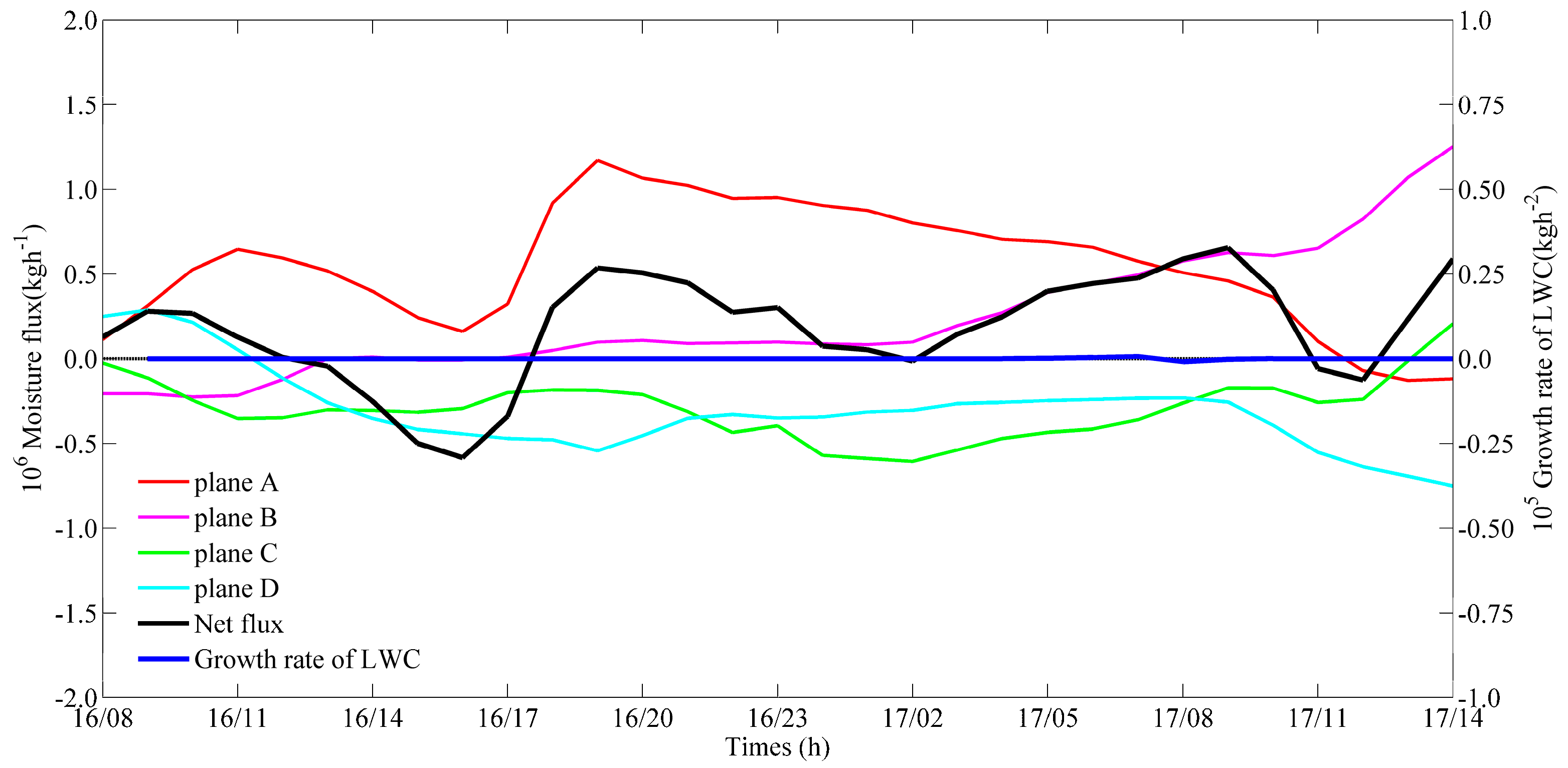
Figure 8 presents the water vapor flux from the east (A), south (B), west (C), and north (D) planes of the “box” model (see Figure 1). It could be observed that the water vapor influx through Plane A (red line) plays the most important role in determining the net flux peak. From 08:00 on the 16th to 11:00 on the 17th, Plane A consistently showed positive values, indicating the prevalence of low-level eastward wind in the near-surface layer, which is consistent with the observations (Figure 2c). The water vapor transport at Plane A significantly increased from 17:00 on the 16th, reaching its peak at 21:00. Although there was a gradually decreasing trend thereafter, the positive moisture influx remained at a relatively high level.
Before the formation of fog, the water vapor net flux convergence (black line) within the “box” exhibited a similar trend to the water vapor influx of Plane A. Both reached their peaks at 21:00 on the 16th, indicating that the water vapor influx induced by eastward wind at Plane A played a crucial role in the net convergence. Correspondingly, the fog water growth rate began to increase at 23:00 on the 16th, reaching its maximum at 03:00 on the 17th. Around 02:00 on the 17th, when the dense fog formed along the western coastal zone of the Bohai Sea, the net convergence of water vapor flux slightly weakened, possibly due to the phase transition of water vapor to liquid water through fog condensation. The trough of net water vapor at this period was consistent with the peak growth rate of LWC (blue line). It could also be attributed to the enhancement of the south airflow (purple line) at Plane B, resulting in convergence shear lines with the eastward airflow within the “box” area. This wind shear line was a zone of convergence that created forced upward motion, leading to a reduction in water vapor in the lower layer.
In terms of the relative contributions of water vapor flux at the four planes to the formation of dense fog, the water vapor influx at Plane A maintained a high positive value both before and during fog formation, reaching a maximum of 1.5 × 10⁶ kg/h. The water vapor influx at the Plane B boundary started to increase significantly at 02:00 on the 17th, but its maximum value did not exceed 0.6 × 10⁶ kg/h until the end of the fog process at 08:40 on the 17th. The water vapor fluxes at Planes C and D were outflows, with flux values maintained around −0.5 × 10⁶ kg/h. This indicates that the eastward wind-driven moisture transport associated with the return flow contributed the necessary water vapor for fog water condensation.
In order to gain a precise understanding of the vertical distribution of water vapor flux in the lower atmosphere from different directions, we present the water vapor flux cross-sections at different times for the four planes (Figure 9). To account for the fact that the “box” model presented in Figure 8 only covers Tianjin city, to visualize the spatial distribution of water vapor transport comprehensively, we extended the top of the “box” model to 2.1 km and expanded the horizontal range to cover most of the Bohai Sea’s west coast region (38.0–41.0° N, 116.5–120.5° E) (see Figure 1). The planes are redefined as A1, B1, C1, and D1 for the east, south, west, and north, respectively.
Figure 9 displays the water vapor flux profiles for Planes A1, B1, C1, and D1 at 12:00 (Figure 9a,e,i,m), 18:00 (Figure 9b,f,j,n), 21:00 on the 16th (Figure 9c,g,k,o), and 06:00 on the 17th (Figure 9d,h,l,p), with positive values indicating inflow. At 12:00 on the 16th, under the dominance of the eastward wind, most of the water vapor entered the “box” through Plane A1, with the strongest water vapor flux below 300 m and a substantial flux extending to 600 m (Figure 9a). The situation resembles Bohai sea-effect snowstorms, where shallow and moisture-laden layers do not exceed 925 hPa [33,34]. Although the eastward water vapor belt narrowed during the night, the flux showed gradually increasing intensity (Figure 9b), corresponding to the peak at 21:00 on the 16th (Figure 8). Subsequently, as the dominant wind direction shifted and the wind weakened (Figure 6), the water vapor transport gradually decreased but remained positive, contributing to the water vapor supply (Figure 9d).
After 18:00 on the 16th, Plane B1 exhibited weak water vapor transport at 300~1500 m, with the intensity center around 600 m (Figure 9f), representing the contribution of moisture from the southwestern airflow front (Figure 6). However, compared to the water vapor influx of Plane A1, it was still significantly less in magnitude. Planes C1 and D1 mainly showed water vapor outflow below 1 km. Plane D1 displayed weak positive water vapor advection in the shallow layer near the mountain surface at 21:00 on the 16th (Figure 9o) and 06:00 on the 17th (Figure 9p), possibly related to nocturnal downslope flow. Plane D1 continued to exhibit predominant water vapor outflux.
The diagnostic results from different-sized “box” models all indicate that the eastward wind-driven moisture transport associated with the return flow contributed significantly to the water vapor required for dense fog formation. Although the southwestern airflow intensified after the early morning of the 17th, it mainly played a role in lifting the fog top, with a relatively minor contribution to water vapor.

4.3. Backward Trajectory Analysis

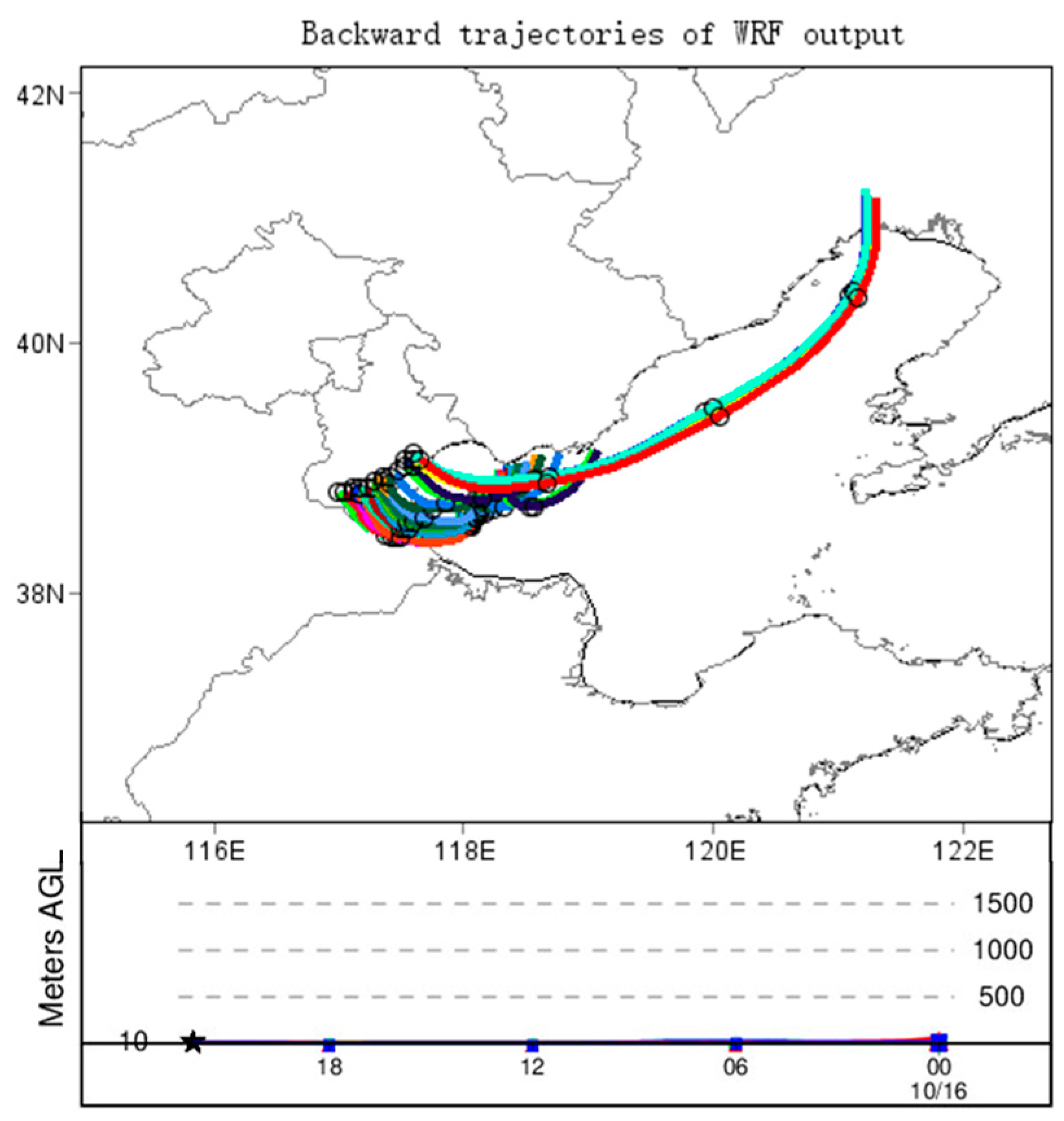
In order to clearly determine the water vapor sources and transport characteristics during the heavy fog event, the Hybrid Single Particle Lagrangian Integrated Trajectory Model (HYSPLIT) was employed for backward trajectory tracking. The driving data were from high-resolution WRF simulation results as analyzed in the preceding sections. To focus on the main points, we studied the target air parcels with high liquid water content (LWC > 0.6 g/kg) at a height of 10 m in the Bohai Sea western coastal area at 06:00 on the 17th (Figure 10). The results indicated that the target air parcels originated from the Bohai Sea, with their farthest traceability reaching the coastal area of Liaodong Bay, the northernmost bay of the Bohai Sea. This trajectory was consistent with the water vapor path obtained using the Eulerian method in Figure 6a–d. Furthermore, these air parcels originated from the lower atmospheric layers, maintaining relatively low altitudes throughout the journey towards the fog area.

5. Sea Effect and Its Inherent Connection with Dense Fog over the Western Coast of the Bohai Sea

5.1. Water Vapor Flux, Sensible Heat Flux, and Sea-Air Temperature Difference of the Bohai Sea

Considering that moisture advection initially originates as dry air flowing over the Northeast Plain (Figure 6a,e) and undergoes modifications during its passage over the Bohai Sea, the influence of the Bohai sea effect on northeast return flow will be investigated in this section. Figure 11 presents the distribution of vertical water vapor flux, sensible heat flux, and sea-air temperature difference over the ocean/land surface at different times. The ocean surface tends to maintain a higher level of moisture compared to land surfaces. This phenomenon elucidates the significant differences in water vapor flux observed between ocean and land surfaces, as shown in Figure 11c. During the daytime on the 16th, Liaodong Bay exhibited a prominent maximum center of water vapor flux exceeding 100 × 10−6 kg m−2 s−1 (Figure 11a) and a sensible heat flux center of 100 Wm−2 (Figure 11e). Correspondingly, the sea-air temperature difference during this period ranged between +5 °C and +8 °C (Figure 11i). These simulated results indicate a significant water–heat exchange in the region, highlighting it as a crucial area contributing to the modification of air masses.
With the continuous modification of air masses over the warm sea surface, both water vapor flux and heat flux (Figure 11b,f), coupled with decreasing sea–air temperature difference (Figure 11j), decreased during nighttime. This resulted in a weakening of the advection of heat and water vapor by the return flow toward the western coast of the Bohai Sea (Figure 6). However, even during this period, the water vapor flux over the Bohai Sea remained two to seven times higher than that over the land (Figure 11c). The water vapor flux over the northern Bohai Sea exceeded 50 × 10−6 kg m−2 s−1, and the western Bohai Sea reached 20 × 10−6 kg m−2 s−1, while water vapor flux over the land surface generally fell below 10 × 10−6 kg m−2 s−1, or even became negative. This suggests that the warm sea surface of the Bohai Sea, through vertical transport of water vapor and heat, altered the temperature and humidity characteristics of the northeast return flow. The modified air mass, driven by the eastward wind, infiltrated the cold west coast, resulting in the formation of dense fog.

5.2. Sensitivity Experiment on Evaporation Intensity of the Bohai Sea

To analyze the impact of Bohai Sea evaporation on the formation of dense fog along the western coast of the Bohai Sea, this study, using the simulation described above as the control experiment (CTL), designed a sensitivity experiment (EXP) by modifying the evaporation intensity. Based on the conclusion from the previous section that water vapor flux over the Bohai Sea was two to seven times that of the land during the simulation period, we attempted to modify the surface layer parameterization scheme by multiplying the surface evaporation coefficient of the ocean by a factor of 0.1, while keeping the land evaporation coefficient unchanged.
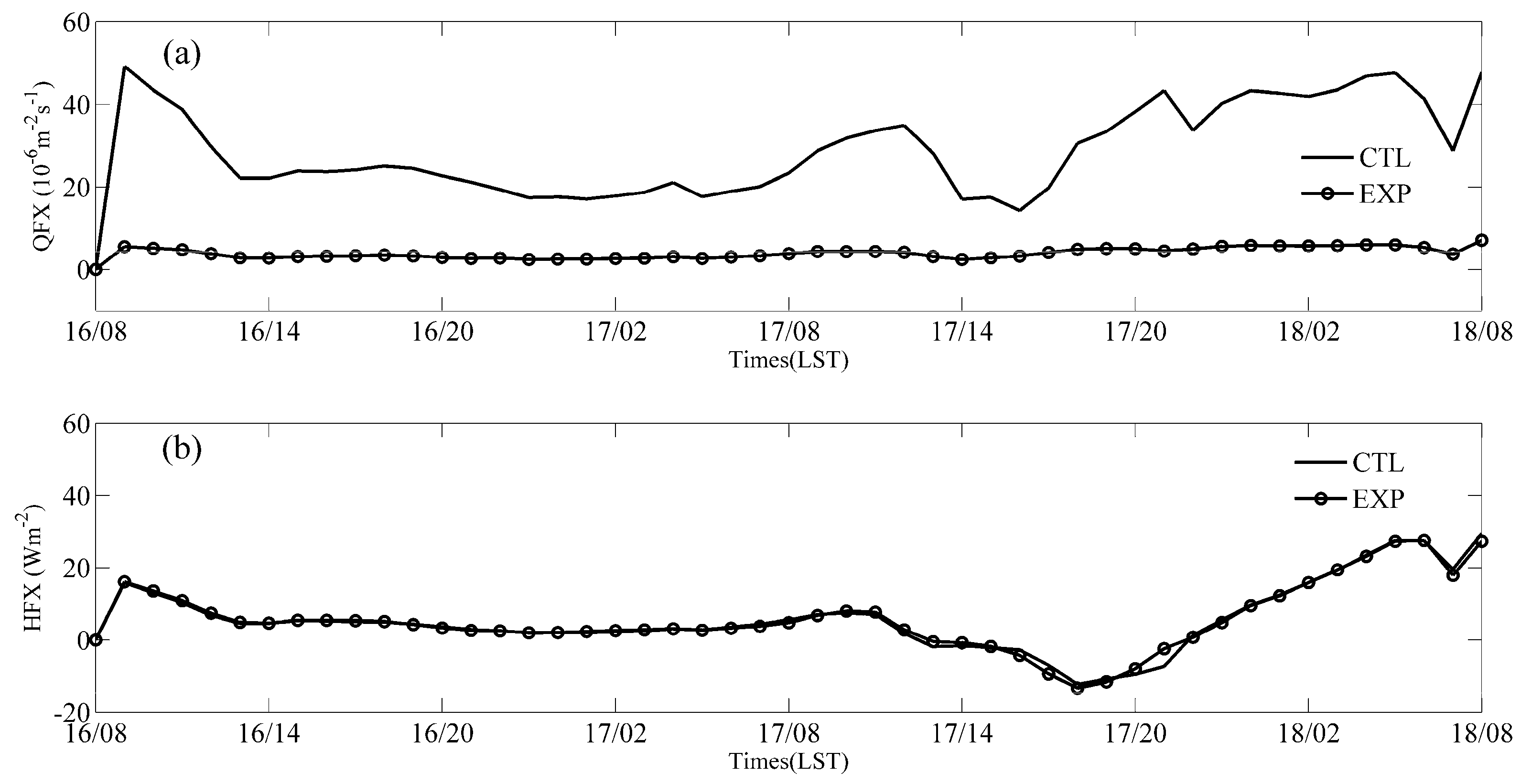
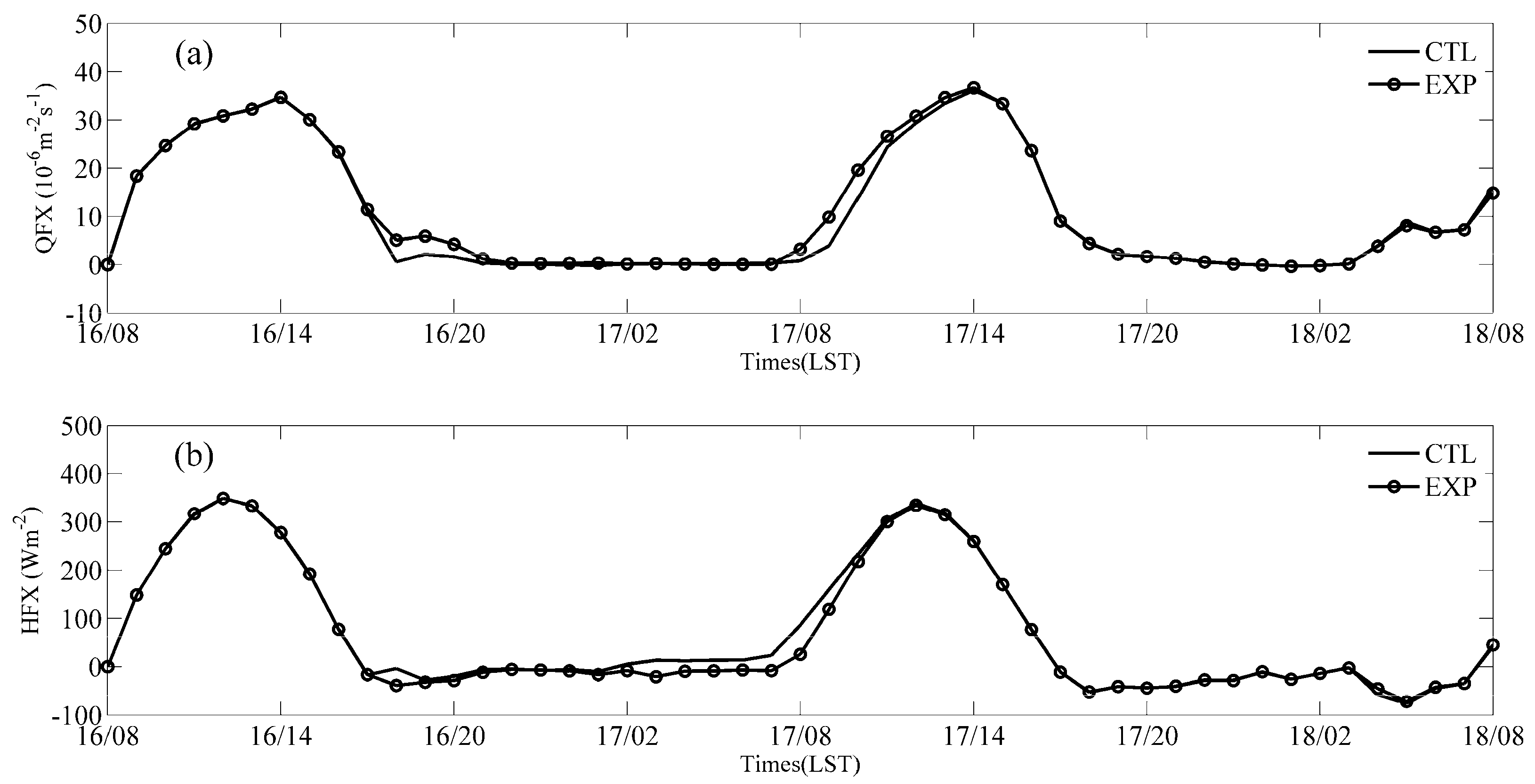
Figure 12 illustrates the vertical water vapor flux from the surface for the EXP experiment. With a reduced ocean evaporation coefficient, the vertical water vapor flux over the Bohai Sea significantly decreased compared to the CTL experiment (Figure 11a–d). Furthermore, the surface flux of water vapor and sensible heat over the marine station (Bohai Chengbei A platform, 38.45° N, 118.42° E) (Figure 13) and land station (Tianjin city station, 39.04° N, 117.12° E) (Figure 14) are presented. As only the evaporation intensity of the marine station decreased by an order of magnitude, there was no difference in the sensible heat flux simulated between the EXP and CTL experiments (Figure 13). For the land station, both the water vapor flux and sensible heat flux showed little variation, indicating no change in land evaporation intensity. In Figure 14b, the sensible heat flux simulated by the EXP experiment at the land station was slightly lower than that of the CTL experiment from 02:00 to 11:00 on the 17th, while the vertical water vapor flux was slightly higher. This difference was attributed to the fact that the EXP experiment did not result in fog formation during the period 02:00 to 08:00 on the 17th (Figure 15). Further diagnostic analysis of water vapor flux in the “box” model (Figure 16) indicated that the water vapor influx from Plane A simulated by the EXP experiment was significantly reduced compared to that of the CTL experiment from 17:00 on the 16th to 07:00 on the 17th. This resulted in a peak net water vapor convergence within the “box” region of only 0.5 × 10⁶ kg/h in the EXP experiment, half of the 1.0 × 10⁶ kg/h in the CTL experiment, and barely any increase in LWC. The sensitivity experiment confirmed that the essential condition for the formation of dense fog was contributed by the water vapor transport guided by the northeast return flow. The moisture advection induced by the Bohai sea effect was a crucial factor in the formation of dense fog, since the fog along the west coast of the Bohai Sea was not generated in the EXP experiment. This was analogous to the conclusion drawn by Li et al. [2] in their analysis of sea-effect snowfall, namely that the water vapor originates entirely from evaporation of the Bohai Sea.

6. Conclusions

Utilizing data from meteorological stations and a 255 m meteorological tower, along with the results from the WRF model, this analysis primarily investigated the intrinsic connection between the Bohai sea effect and dense fog along the western coast. Additionally, it explored the humidity contribution of return flow to the formation of dense fog through moisture budget analysis. Finally, with the aid of sensitivity experiments, it was demonstrated that the Bohai sea effect plays a decisive role in the formation of fog along the western coast. The main conclusions were as follows:
(1)
In the early stage of the formation of dense fog on the western coast of the Bohai Sea, a small cold air mass from the Lake Baikal region split and moved northeast. As the cold air moved eastward, it was blocked by the Changbai Mountains, and a shallow flow moved southward from the Northeast Plain below 925 hPa. This return flow circulated to the western coast of the Bohai Sea, with its associated water vapor advection playing a crucial role in continuously humidifying the atmosphere on the western coast. Coupled with surface radiative cooling and the continually strengthening inversion at night, this process was conducive to the formation of dense fog.
(2)
According to the moisture budget, the low-level total moisture flux across the eastern boundary significantly contributed to the accumulation of water vapor on the western coast of the Bohai Sea, and its variations were almost exactly in phase with those of the net moisture flux convergence. Backward trajectory tracking further indicated that the water vapor affecting the near-surface fog on the western coast of the Bohai Sea could be traced back to the coast of Liaodong Bay, and the return flow maintained a low altitude throughout its journey towards the fog area.
(3)
An examination of water vapor flux, sensible heat flux, and sea–air temperature difference disclosed a notable sea–air interaction over the northern Bohai Sea, especially in Liaodong Bay. A subsequent sensitivity experiment corroborated that the requisite water vapor for the formation of dense fog on the west coast primarily emanated from Bohai Sea evaporation. The sea effect enhanced the moisture content in the boundary layer above the sea surface through vertical water vapor exchange, influencing the fog formation process along the western coast of the Bohai Sea.
This study of the fog event associated with the Bohai sea effect indicates that, for short-term forecasting of such fog cases, attention should be directed toward the sea–air temperature difference, vertical water vapor flux in the northern Bohai Sea (particularly in Liaodong Bay), and the occurrence of a low-level jet along the western coast of the Bohai Sea. Future studies on this topic are clearly needed. Additionally, empirical orthogonal function decomposition will be applied to further investigate a multitude of cases of this fog type, providing an in-depth analysis of the formation mechanisms.

Author Contributions

Conceptualization, B.W. and J.Y.; methodology, M.T.; software, M.T. and B.W.; validation, Z.J. and H.L.; formal analysis, M.T.; investigation, J.W.; resources, B.W.; data curation, Y.G.; writing—original draft preparation, M.T.; writing—review and editing, J.Y.; visualization, M.T. and Z.J.; supervision, B.W.; project administration, M.T.; funding acquisition, M.T. and J.Y. All authors have read and agreed to the published version of the manuscript.

Funding

This research was funded by the Natural Science Foundation of China (Grant No. 42205009, 42205092, 42105084), the Applied Foundational Research Project of Tianjin (Grant No. 22JCQNJC00370), Science and Technology Collaborative Innovation Fund of Bohai Rim Region (QYXM202112, QYXM202202), and Scientific Research Projects of Tianjin Meteorological Bureau (202306ybxm02, 202309ybxm04).

Institutional Review Board Statement

Not applicable.

Informed Consent Statement

Not applicable.

Data Availability Statement

The site https://rda.ucar.edu/datasets/ds083.2/index.html (accessed on 30 July 2023) provides for NCEP FNL downloading. The manual and automatic surface data are available at http://data.cma.cn (accessed on 1 June 2023) from National Meteorological Information Center of China. The meteorological values from 15 vertical levels of Tianjin atmospheric boundary layer observation station can be obtained from http://tj.cma.gov.cn (accessed on 1 July 2023). Modeling data can be accessed by contacting the first author: Meng Tian ([email protected]).

Acknowledgments

The authors would like to thank Shanhong Gao from Ocean University of China for his valuable insights and suggestions during the course of this research, as well as for providing a conducive research environment. We also acknowledge Yimin Ma from the Australian Bureau of Meteorology for his guidance on the water vapor budget algorithm.

Conflicts of Interest

The authors declare no conflict of interest.

References

  1. Bao, B.; Ren, G.Y. Sea-effect precipitation over the Shandong Peninsula, Northern China. J. Appl. Meteorol. Climatol. 2018, 57, 1291–1308. [Google Scholar] [CrossRef]
  2. Li, J.H.; Gao, W.H.; Li, F. Water vapor and cloud microphysical characteristics of a sea-effect snowstorm in Shandong Peninsula, China. J. Atmos. Sol. Terr. Phys. 2022, 235, 105910. [Google Scholar] [CrossRef]
  3. Li, Y.J.; Chen, X.L. Forecasting of Technology of Meteorological Disaster and Marine Disaster in Bohai Sea; China Meteorological Press: Beijing, China, 2014. (In Chinese) [Google Scholar]
  4. Koračin, D.; Businger, J.A.; Dorman, C.E.; Lewis, J.M. Formation, evolution, and dissipation of coastal sea fog. Bound. Layer Meteorol. 2005, 117, 447–478. [Google Scholar] [CrossRef]
  5. Koračin, D.; Dorman, C.E.; Lewis, J.M.; Hudson, J.G.; Wilcox, E.M.; Torregrosa, A. Marine fog: A review. Atmos. Res. 2014, 143, 142–175. [Google Scholar] [CrossRef]
  6. Jin, G.; Gao, S.; Shi, H.; Lu, X.; Yang, Y.; Zheng, Q. Impacts of sea-land breeze circulation on the formation and development of coastal sea fog along the Shandong Peninsula: A case study. Atmosphere 2022, 13, 165. [Google Scholar] [CrossRef]
  7. Wang, X.; Huang, F.; Zhou, F.X. Climatic characteristics of sea fog formation of the Huanghai Sea in summer. Mar. Forecast. 2006, 8, 26–34. (In Chinese) [Google Scholar]
  8. Huang, J.; Wang, X.; Zhou, W.; Huang, H.; Wang, D.; Zhou, F. The characteristics of sea fog with different airflow over the Huanghai Sea in boreal spring. Acta Oceanol. Sin. 2018, 29, 3–12. [Google Scholar] [CrossRef]
  9. Sun, J.; Huang, H.; Zhang, S.; Mao, W. How sea fog influences inland visibility on the Southern China coast. Atmosphere 2018, 9, 344. [Google Scholar] [CrossRef]
  10. Mei, M.; Ding, Y.H.; Wang, Z.Y. Impact of the return flow on heavy pollution in winter over the Beijing-Tianjin-Hebei region. J. Meteorol. Res. 2023, 37, 370–386. [Google Scholar] [CrossRef]
  11. Ye, X.; Song, Y.; Cai, X.; Zhang, H. Study on the synoptic flow patterns and boundary layer process of the severe haze events over the North China Plain in January. Atmos. Environ. 2016, 124, 129–145. [Google Scholar] [CrossRef]
  12. Zheng, Y.; Li, R.; Shi, D.D.; Wang, Y.N.; Sun, M.N. Characteristics of offshore and coastal sea fog in the mid-west Bohai Sea. Mar. Forecast. 2016, 33, 74–80. (In Chinese) [Google Scholar]
  13. Wu, B.G.; Wang, Z.Y. Near-surface meteorological characteristics of sudden morning fog process under the background of North China backflow. In Proceedings of the 35th China Meteorological Annual Conference, S13 Atmospheric Physics, and Environment, Anhui, China, 24 October 2018. (In Chinese). [Google Scholar]
  14. Brown, R.; Roach, W.T. The physics of radiation fog: II-a numerical study. Q. J. R. Meteorol. Soc. 1976, 102, 335–354. [Google Scholar]
  15. Oliver, D.A.; Lewellen, W.S.; Williamson, G.G. The interaction between turbulent and radiative transport in the development of fog and low-level stratus. J. Atmos. Sci. 1978, 35, 301–316. [Google Scholar]
  16. Duynkerke, P.G. Radiation fog: A comparison of model simulation with detailed observations. Mon. Weather Rev. 1991, 119, 324–341. [Google Scholar] [CrossRef]
  17. Nakanishi, M. Large-eddy simulation of radiation fog. Bound. Layer Meteorol. 2000, 94, 461–493. [Google Scholar] [CrossRef]
  18. Pagowski, M.; Gultepe, I.; King, P. Analysis and modeling of an extremely dense fog event in Southern Ontario. J. Appl. Meteorol. Climatol. 2004, 41, 3–16. [Google Scholar] [CrossRef]
  19. Kim, C.K.; Yum, S.S. A numerical study of sea-fog formation over cold sea surface using a one-dimensional turbulence model coupled with the Weather Research and Forecasting Model. Bound. Layer Meteorol. 2012, 143, 481–505. [Google Scholar] [CrossRef]
  20. Tu, X.; Yao, R.; Hu, L.; Xu, D.; Yang, H. Observation and simulation study on the macro-microphysical characteristics of a coastal fog offshore Zhejiang Province of China. Atmos. Res. 2023, 292, 106537. [Google Scholar] [CrossRef]
  21. Hong, S.Y.; Noh, Y.; Dudhia, J. A new vertical diffusion package with an explicit treatment of entrainment processes. Mon. Weather Rev. 2006, 134, 2318–2341. [Google Scholar] [CrossRef]
  22. Iacono, M.J.; Delamere, J.S.; Mlawer, E.J.; Shephard, M.W.; Clough, S.A.; Collins, W.D. Radiative forcing by long-lived greenhouse gases: Calculations with the AER radiative transfer models. J. Geophys. Res. 2008, 113, D13103. [Google Scholar] [CrossRef]
  23. Dudhia, J. A multi-layer soil temperature model for MM5. In Proceedings of the Sixth PSU/NCAR Mesoscale Model User’s Workshop, Boulder, CO, USA, 22–24 July 1996; pp. 22–24. [Google Scholar]
  24. Hong, S.Y.; Lim, J.-O.J. The WRF single-moment 6-class microphysics scheme (WSM 6). J. Korean Meteorol. Soc. 2006, 42, 129–151. [Google Scholar]
  25. Zhang, D.L. Roles of various diabatic physical processes in mesoscale models. Chin. J. Atmos. Sci. 1998, 22, 548–561. (In Chinese) [Google Scholar]
  26. Jeworrek, J.; West, G.; Stull, R. Evaluation of cumulus and microphysics parameterizations in WRF across the convective gray zone. Weather Forecast. 2019, 34, 1097–1115. [Google Scholar] [CrossRef]
  27. Wilson, T.H.; Fovell, R.G. Modeling the evolution and life cycle of radiative cold pools and fog. Weather Forecast. 2018, 33, 203–220. [Google Scholar] [CrossRef]
  28. Ding, Y.H.; Liu, Y.J. Analysis of long-term variations of fog and haze in China in recent 50 years and their relations with atmospheric humidity. Sci. China Earth Sci. 2014, 57, 36–46. [Google Scholar] [CrossRef]
  29. Liu, Z.; Wang, H.; Peng, Y.; Zhang, W.; Zhao, M. Multiple regression analysis of low visibility focusing on severe haze-fog pollution in various regions of China 2018. Atmosphere 2022, 13, 203. [Google Scholar] [CrossRef]
  30. Price, J. Radiation fog. Part I: Observations of stability and drop size distributions. Bound. Layer Meteorol. 2011, 139, 167–191. [Google Scholar] [CrossRef]
  31. Liu, D.Y.; Yan, W.L.; Yang, J.; Pu, M.J.; Niu, S.J.; Li, Z.H. A study of physical processes of an advection fog boundary layer. Bound. Layer Meteorol. 2018, 158, 125–138. [Google Scholar] [CrossRef]
  32. Zhang, Y.; Xue, M.; Zhu, K.; Zhou, B. What is the main cause of diurnal variation and nocturnal peak of summer precipitation in Sichuan Basin, China? The key role of boundary layer low-level jet inertial oscillations. J. Geophys. Res. Atmos. 2019, 124, 2377–2864. [Google Scholar] [CrossRef]
  33. Yang, C.F. Multiscale Study of Sea-Effect Snowfall in the Bohai Sea. Ph.D. Thesis, Nanjing University of Information Science & Technology, Nanjing, China, 2010. (In Chinese). [Google Scholar]
  34. Zheng, Y. Observational Analysis and Numerical Simulation of Cloud Characteristics of the Bohai Sea-Effect Snowstorms. Master’s Thesis, Ocean University of China, Qingdao, China, 2013. (In Chinese). [Google Scholar]
Figure 1. (a) The model domains for numerical testing, with the red dot indicating the location of the Tianjin atmospheric boundary layer observation station. (b) The large box represents the diagnostic area for the western coastal zone of the Bohai Sea, while the small box represents the area of special concern for Tianjin city.
Atmosphere 15 00326 g001
Figure 2. Fog distribution at (a) 02:00 and (b) 08:00 on 17 October 2007 observed by the manual observations of the China Meteorological Administration (The red dots represent fog observation stations, the green dots represent stations with light fog, and the black dots represent stations without fog. The criteria for judging fog are when there is no observed precipitation or dust, and atmospheric visibility is less than 1 km. Visibility less than 10 km is considered as light fog); (c) Wind vectors within the height of 250 m from 08:00 on the 16th to 08:00 on the 17th at the Tianjin atmospheric boundary layer observation station; (d) Relative humidity at 220 m, 120 m, and 10 m, and visibility at 2 m from 08:00 on the 16th to 12:00 on the 17th (time resolution: 10 min) at the Tianjin atmospheric boundary layer observation station. The gray shaded area represents the existing period of dense fog.
Atmosphere 15 00326 g002
Figure 3. (a) 500 hPa wind field at 20:00 on the 16th; (b) 925 hPa wind field at 20:00 on the 16th; (c) Surface wind field at 08:00 on the 16th; (d) Surface wind field at 20:00 on the 16th.
Atmosphere 15 00326 g003
Figure 4. Spatial distributions of fog area observed ((ae), shaded with 2 m relative humidity which is higher than 95%) and simulated ((fj), shaded with liquid water content (LWC) in the lowest model layer which is higher than 0.005 g/kg): (a) 02:00; (b) 04:00; (c) 06:00; (d) 08:00; (e) 10:00 on the 17th; the times of (fj) correspond to (ae), respectively.
Atmosphere 15 00326 g004
Figure 5. Comparison of the observed (OBS) and simulated (SIM) results at the Tianjin station from 08:00 on the 16th to 08:00 on the 18th, (a) 2m temperature T (°C); (b) dew point temperature Td (°C).
Atmosphere 15 00326 g005
Figure 6. Simulated water vapor advection (unit: g/(cm·s·hPa), shaded, (ad)) and temperature advection (unit: °C/s, shaded, (eh)) at the height of 1000 hPa, with superimposed wind vectors (unit: m/s): (a) 09:00 on the 16th; (b) 20:00 on the 16th; (c) 02:00 on the 17th; (d) 06:00 on the 17th. The times of (eh) correspond to (ad), respectively.
Atmosphere 15 00326 g006
Figure 7. Vertical profiles of (a) specific humidity; (b) temperature; (c) wind speed at different times at the Tianjin station.
Atmosphere 15 00326 g007
Figure 8. The time series of simulated water vapor fluxes from four directions, net flux convergence, and the growth rate of LWC in a box model within a height of 200 m. The red, purple, green, and cyan lines represent the water vapor flux passing through Planes A, B, C, and D of the box model, respectively. The black line represents the net flux convergence, and the blue line represents the growth rate of LWC.
Atmosphere 15 00326 g008
Figure 9. The water vapor flux (shading) through the four planes in the box model. The first, second, third, and fourth rows represent the moisture flux passing through Planes A1, B1, C1, and D1, respectively: (a) 12:00 on the 16th; (b) 18:00 on the 16th; (c) 21:00 on the 16th; (d) 06:00 on the 17th. The times of (eh), (il), and (mp) correspond to (ad), respectively.
Atmosphere 15 00326 g009
Figure 10. Backward trajectories of the target particles (LWC > 0.6 g/kg) at 10 m from 08:00 on the 16th to 06:00 on the 17th.
Atmosphere 15 00326 g010
Figure 11. Vertical water vapor flux (QFX, unit: 10−6 kgm−2s−1, (ad)), sensible heat flux (HFX, unit: Wm−2, (eh)), and sea–air temperature difference (SST-AT, unit: °C, (il)) on the ocean/land surface for the following times: (a) 09:00 on the 16th; (b) 15:00 on the 16th; (c) 23:00 on the 16th; (d) 06:00 on the 17th. The times of (eh) and (il) correspond to (ad), respectively.
Atmosphere 15 00326 g011
Figure 12. Same as Figure 11, but for the sensitivity experiment (EXP) of evaporation intensity for the following times: (a) 09:00 on the 16th; (b) 15:00 on the 16th; (c) 23:00 on the 16th; (d) 06:00 on the 17th.
Atmosphere 15 00326 g012
Figure 13. Comparison of the time series of (a) vertical water vapor flux (QFX) and (b) heat flux (HFX) at Bohai Chengbei A platform station (38.45° N, 118.42° E) simulated by the EXP and CTL experiments.
Atmosphere 15 00326 g013
Figure 14. Comparison of the time series of (a) vertical water vapor flux (QFX) and (b) heat flux (HFX) for the Tianjin station (39.04° N, 117.12° E).
Atmosphere 15 00326 g014
Figure 15. Spatial distributions of fog area observed Figure 4f–j, but for the EXP experiment: (a) 02:00; (b) 04:00; (c) 06:00; (d) 08:00; (e) 10:00 on the 17th.
Atmosphere 15 00326 g015
Figure 16. Same as Figure 8 but for the EXP experiment.
Atmosphere 15 00326 g016
Disclaimer/Publisher’s Note: The statements, opinions and data contained in all publications are solely those of the individual author(s) and contributor(s) and not of MDPI and/or the editor(s). MDPI and/or the editor(s) disclaim responsibility for any injury to people or property resulting from any ideas, methods, instructions or products referred to in the content.