Article

Synoptic Weather Patterns and Atmospheric Circulation Types of PM2.5 Pollution Periods in the Beijing-Tianjin-Hebei Region

School of Geographical Sciences, Hebei Key Laboratory of Environmental Change and Ecological Construction, Hebei Technology Innovation Center for Remote Sensing Identification of Environmental Change, Hebei Provincial Key Laboratory of Information Fusion and Intelligent Control, Hebei Normal University, Shijiazhuang 050024, China
*
Authors to whom correspondence should be addressed.
Atmosphere 2023, 14(6), 942; https://doi.org/10.3390/atmos14060942
Submission received: 13 April 2023 / Revised: 18 May 2023 / Accepted: 25 May 2023 / Published: 27 May 2023
(This article belongs to the Section Air Pollution Control)

Abstract

:
The variation of PM2.5 concentration in the atmosphere is closely related to the variation in weather patterns. The change in weather pattern is accompanied by the corresponding change in atmospheric circulation characteristics. It is necessary to explore the relationship between PM2.5 concentration changes and atmospheric circulation characteristics during pollution periods. In this paper, Lamb-Jenkinson objective classification method is applied to classify daily atmospheric circulation. The pollution periods are calculated and the atmospheric circulation variation rule is obtained. Combined with the physical parameter field (humidity, potential temperature, and potential height), a typical pollution period is analyzed. Additionally, the influence of atmospheric circulation type variation on PM2.5 concentration and transport channel during the pollution period was obtained. The results show that atmospheric circulation types in the study period are dominated by A-type (anticyclonic), N-type (north), and NE-type (northeast), indicating obvious seasonal differences, and the proportion of C-type (cyclonic) circulation was increased significantly in summer. During the pollution period analysis from 2 to 4 January 2019, atmospheric circulation type changed from N-type to NE-type (northeast), the wind direction changed from southeast wind, and the change of pressure gradient was consistent with the trend of the wind field. Moreover, the physical parameter field assisted in verifying the process of the pollution period from the conducive to the accumulation of PM2.5 to conducive to the deposition of pollutants and external transport. The research results would provide theoretical support for PM2.5 prediction during the pollution period and also supply a theoretical and technical basis for the establishment of ecological compensation standards for air pollution and atmospheric environmental control.

1. Introduction

The problem of air quality has seriously affected people’s health and restricted the long-term healthy development of the economy. It has become a key area controlled by relevant government agencies and a hot topic concerned by the people [1,2]. Although scholars and policymakers have made great efforts to reduce and control atmospheric pollutants in recent years, PM2.5 (Fine particles with a diameter ≤ 2.5 µm) still has long been the primary air quality pollutant in China’s major cities [3,4]. In order to deal with serious air fine particulate matter (PM2.5) pollution, the Chinese government issued the Air Pollution Prevention and Control Action Plan in 2013 to improve the effectiveness of environmental supervision in key regions. Scholars also analyzed and evaluated the emission reduction effect of atmospheric pollutants under the air quality assurance program of typical activities in urban agglomerations in China in recent years, including the Beijing-Tianjin-Hebei (BTH) region [5], the Yangtze River Delta [6], and the Fen-Wei Plain [7]. In order to achieve the established emission reduction effect, most scholars have carried out a large number of studies on the causes of atmospheric pollutants, and the forward and backward trajectory analysis of PM2.5 concentration. Many scholars have found that meteorological factors are highly correlated with PM2.5 concentration, deposition, and transport, including temperature, humidity, and wind field. Zhang et al. [8] found that PM2.5 concentration in urban areas was positively correlated with minimum wind speed, especially in urban and suburban areas. It was more significantly correlated with minimum relative humidity, while it was significantly positively correlated with maximum temperature in rural areas. PM2.5 extreme weather events are more likely to occur when spring humidity is low in the central and southeastern United States. Tran et al. [9] used 10 years of observation data on the relationship between meteorological conditions (including temperature, wind field, and relative humidity) and PM2.5 concentration in Fairbanks area. In the heating season, PM2.5 concentration exceeding the national air quality standard for 24 h mainly occurs under the conditions of low wind speed (or even clam wind), extremely low temperature, and water-vapor pressure < 2 hPa multi-day temperature inversion, which inhibit the deposition of polluted air and is not conducive to external transport. Additionally, atmospheric thermodynamic equilibrium is one of the factors affecting the transport and deposition of PM2.5. Feng et al. [10] provides that PM2.5 and gaseous air pollutants (including SO2, NO2, O3, and CO) between atmospheric thermodynamic equilibrium, the temperature change caused by unbalanced thermodynamics balance changes is the main reason for the winter PM2.5 changes in China’s major cities, and emissions and long-distance transmission exists and is not significant. In a word, temperature, precipitation, and atmospheric pressure have a great influence on PM2.5 concentration and its transport, especially in the winter heating season.
Atmospheric circulation plays the role of airflow transmission, energy conversion, and water vapor transport in the whole meteorological system, affecting the change of the whole weather system and even the change of climate. When atmospheric circulation characteristics are in a stable state, various meteorological elements are in a stable law. Accompanied by abnormal weather pattern changes, atmospheric circulation characteristics will also be changed [11,12]. Accurately judging the change of atmospheric circulation characteristics is not only the premise of weather forecasting but is also the necessary condition for pollutant forecasting. Domestic and foreign scholars have three methods for the statistical classification of atmospheric circulation characteristics. Firstly, subjective classification is completed by the researchers according to their professional knowledge and based on weather maps and meteorological principles. Due to researchers’ subjectivity, there is no systematic method to test and verify the results, so this method has not been widely used [13,14]. Secondly, objective classification is based on an objective algorithm to calculate specific parameters by using basic meteorological data of different times and spaces and to judge the parameters according to specific criteria. It mainly includes T-mode principal component analysis (PCA) [15,16,17] and the Lamb-Jenkinson objective classification method [18,19]. Thirdly, objective classification relies on the quality of original data, and subjective and objective mixed classification has the advantages of simple operation and accurate judgment. Many scholars have verified its practical application value through experiments [20,21].
Related studies have shown that with the Lamb-Jenkinson objective classification method in Asia, especially in China, air pollution study has high feasibility [22,23]. Lamb used the subjective classification method to analyze atmospheric circulation characteristics of the British Isles and concluded that the area was dominated by mixed atmospheric circulation and had no obvious diurnal variation characteristics [24]. Li et al. [25] used the Lamb-Jenkinson objective classification method to reveal the influence of atmospheric circulation on PM2.5 in the North China Plain. The results showed that the three most serious weather patterns were C-type (cyclonic), A-type (anticyclonic), and E-type (east), and proposed that measures should be taken to meet the National Ambient Air Quality Standards under adverse weather conditions. Yan et al. [26] used Lamb-Jenkinson objective classification method combined with the GEO-Chem model to simulate the effectiveness of emission control under potential weather control on reducing PM2.5 pollution in central China during winter haze. The results showed that the surface wind speed in study area was low. Weather patterns and atmospheric circulation types (A-type or C-type) hindered the diffusion of pollutants. At present, most studies focus on the influence of atmospheric circulation characteristics and extreme weather on production and life. Few studies on the combination of pollutants and atmospheric circulation situation, and lack of weather background and physical parameter field in a pollution period.
In this paper, PM2.5 concentration monitoring PM2.5 data in the BTH region during 2019–2022 and Tracking Air Pollution in China (TAP) synthesized data were performed significance test, and TAP data is applied to select a pollution period (From 2 January to 4 January 2019) during the study period. According to the National Ambient Air Quality Standards (GB 3095-2012, grade II) [27], 24 h average PM2.5 concentrations greater than 100 μg/m3 are defined as a pollution period. Lamb-Jenkinson objective classification method is applied to calculate the daily atmospheric circulation characteristics during the study period. Atmospheric circulation characteristics were analyzed with circulation conditions and physical parameter fields during a pollution period, including potential temperature field, humidity, wind field, and atmospheric pressure field characteristics. The results of this study will further explore the accumulation and diffusion rules of atmospheric pollutants in different atmospheric circulation characteristics, provide data support for trans-regional comprehensive remediation of air pollution, contribute to the formulation of ecological compensation standards for air pollution, and provide research support for objective analysis and evaluation of air pollution control effects and policy formulation.

2. Data Set Summary and Study Methods

BTH region is located in the northern part of the North China Plain, which is an important strategic area around the Bohai Sea. This region has a temperate semi-humid and semi-arid continental monsoon climate, with high temperatures in summer and the highest rainfall in the whole year, and low temperatures in winter accompanied by local rain and snow [28]. Figure 1a shows the elevation of the study area, which generally shows the terrain decreasing from the northwest uplift to the southeast, and is dominated by plain landform. Figure 1b provides the land use situation in the BTH region. The main types are cultivated land, forest land, and grassland, accounting for more than 80% of the area.

2.1. Data

2.1.1. Meteorological Data

The meteorological data derived from the National Centers for Environmental Prediction/National Center for Atmospheric Research (NCEP/NCAR) reanalysis data (https://psl.noaa.gov/data/gridded/tables/daily.html), (accessed on 11 March 2023), which is provided by National Oceanic and Atmospheric Administration (NOAA, Washington, DC, USA). This data includes mean sea level pressure, wind field, relative humidity, potential temperature field, geopotential height, and atmospheric pressure field from 1948 to the present. We choose 2019–2022 to download. Its time resolution is hourly average or daily average, the horizontal resolution is 2.5° × 2.5°, and the vertical direction includes 17 layers from 10 hPa to 1000 hPa [29].

2.1.2. PM2.5 Data

The monitoring PM2.5 data are derived from the hourly pollutant concentration data obtained by China Environmental Monitoring Station (http://www.cnemc.cn/), (accessed on 9 March 2023). Monitoring PM2.5 data that have been discontinued for a long time or with large errors were excluded. The number of available monitoring stations in the study area is 73. Data is recorded in μg/m3.
The TAP synthetic data used in this study comes from Tsinghua University, Beijing, China (http://tapdata.org.cn/), (accessed on 15 March 2023). The data are built from monitoring PM2.5 data, satellite measurement data, reanalysis data, and other auxiliary data. The satellite measurement data are mainly Terra/Aqua AOD data. The reanalysis data include NCEP/ Final Operational Global Analysis (FNL) reanalysis data and the second Modern-Era Retrospective analysis for Research and Applications/GEOS Forward Processing (MERRA2/GEOS-FP) reanalysis data. The auxiliary data includes population data, land use situation data, and elevation data [30]. A two-layer random forest model is established through data synthesis. Based on the decision tree method to establish the correlation between the missing data and other parameters, to make up for the missing satellite data [31,32,33]. Data is recorded in μg/m3.

2.2. Lamb-Jenkinson Objective Classification Method

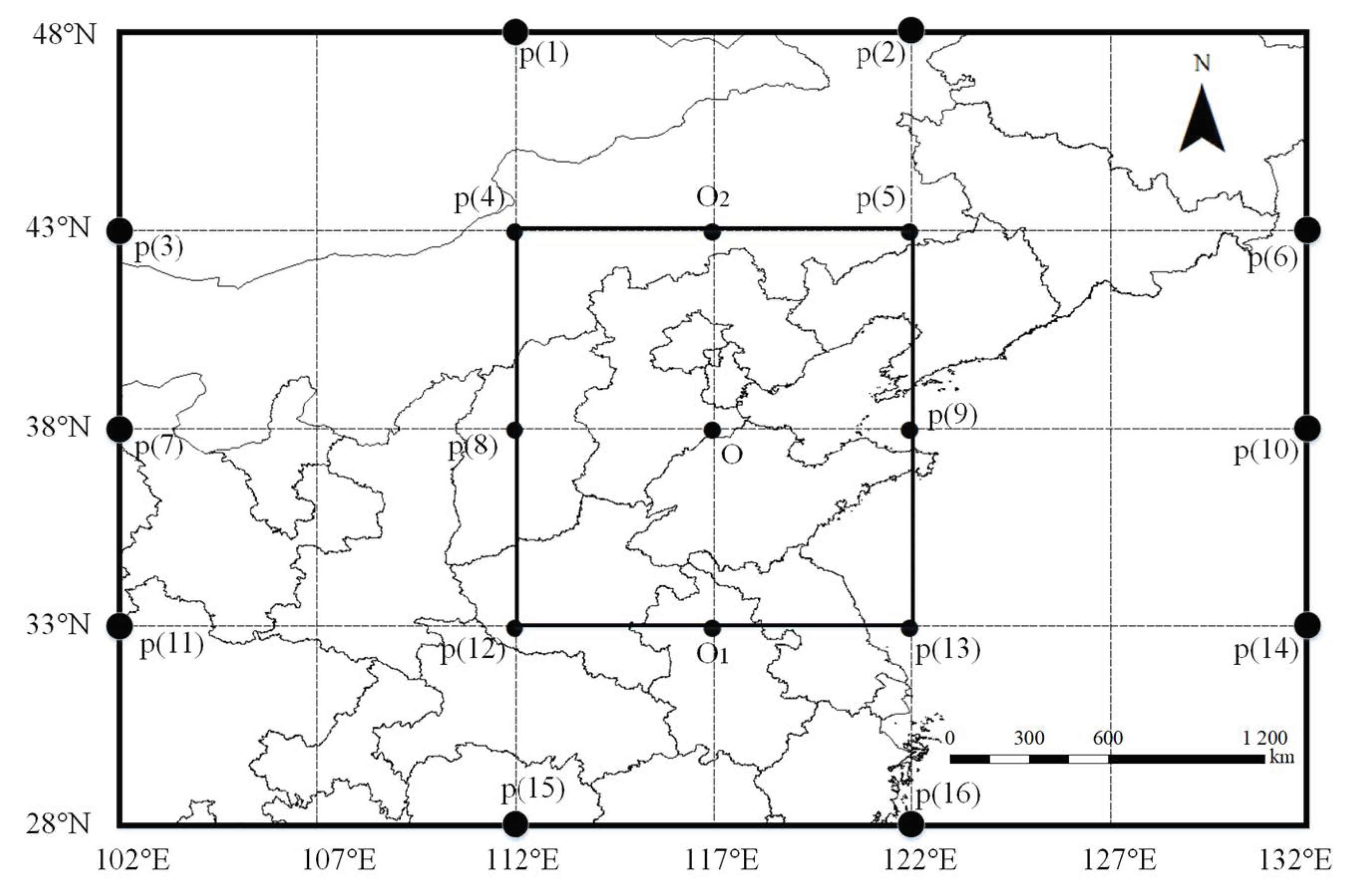
The Lamb-Jenkinson objective classification method can provide an objective numerical description of local atmospheric circulation. Local atmospheric circulation and its relation with climate change are studied from the perspective of synoptic climatology. BTH region is located at 113°–120° E and 36°–43° N. In order to fully include the study area in the inner nested grid, the calculation area is set as 28°–48° N and 102°–132° E, and the coordinates of the center point are set at 117° E and 38° N. The method of different grid point selection is to select points within the research area with an interval of ten longitudes and five latitudes respectively, with a total of 16 grid points. Geostrophic wind ( u , v ) and geostrophic vorticity ( ξ u , ξ v ) at the center point O are calculated using the average daily sea level pressure values at 16 grid points within the region [34]. According to the calculated relation between geostrophic wind and geostrophic vorticity (also known as atmospheric circulation index relation), atmospheric circulation characteristics are divided (Figure 2). The Lamb-Jenkinson objective classification method is applied to calculate the formula of circulation index by Equations (1)–(7):
U = 1 2 p 12 + p 13 p 4 p 5
V = 1 cos α × 1 4 p 5 + 2 p 9 + p 13 p 4 2 p 8 p 12
V = u 2 + v 2
ξ u = u y = sin α s i n α 1 × 1 2 p 15 + p 16 p 8 p 9 sin α s i n α 2 × 1 2 p 8 + p 9 p 1 p 2
ξ v = v x = 1 2 c o s 2 α × 1 4 p 6 + 2 p 10 + p 14 p 5 2 p 9 p 13 + p 3 + 2 p 7 + p 11 p 4 2 p 8 p 12
ξ = ξ u + ξ v
v < 0   α = arctan u v × 180 ° π v > 0   α = arctan u v × 180 ° π
where p n represents the sea level pressure value at the nth grid point. α , α 1 and α 2 respectively represent the latitude values of points O, O1, and O2. V is the geostrophic wind divided into the western component of the geostrophic wind u and the southern component of the geostrophic wind v . ξ is the geostrophic vorticity divided into the meridional gradient ξ u and the zonal gradient ξ v . The latitude of the central point was used as the reference frame, and the units of six circulation indices were hPa/10 latitudes. Table 1 provides the circulation types based on the Lamb-Jenkinson objective classification.

2.3. PM2.5 Data Significance Test Analysis

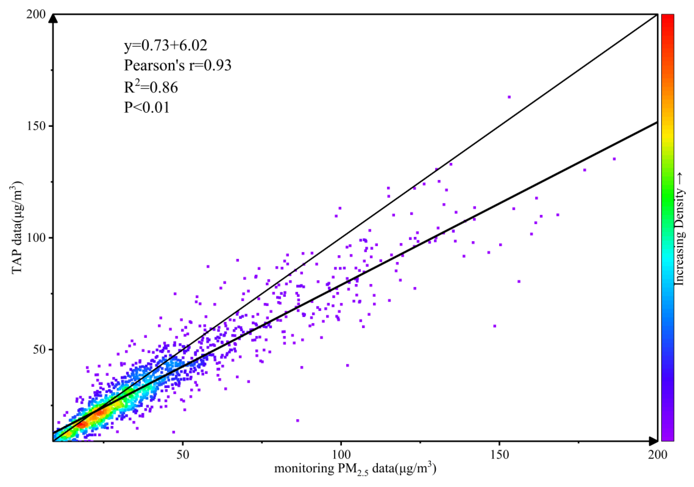
In order to verify the availability of TAP data, the linear regression model is used for the significance test between TAP data and monitoring PM2.5 data. Before the significance test, the monitoring PM2.5 data are cleaned, the missing values are made up and invalid values are eliminated by means of interpolation. The test results are shown in Figure 3. The Person’s r value and R2 value are 0.93 and 0.86 respectively, and pass 0.01 (bilateral) significance tests. In summary, TAP data are consistent with monitoring PM2.5 data, and the data set has high confidence, which can provide reliable high-resolution pollutant concentration data for the Lamb-Jenkinson objective classification scheme.

3. Results

3.1. The Spatiotemporal Differentiation of PM2.5 Concentration in the BTH Region

The atmospheric circulation classification in the BTH region for 2019–2022 is conducted with the Lamb-Jenkinson objective classification method. The results of atmospheric circulation classification have corresponding physical significance. Atmospheric circulation types for 1461 days during the study period were counted by month. Table 2 shows the daily statistical results of each atmospheric circulation type in a specific month. In a study period, A-type (anticyclonic), N-type (north), and C-type (cyclonic) atmospheric circulations appeared most frequently, the rotational flow class and the directional flow class took the dominant role in all types, while the mixed class had relatively few days. In terms of seasonal scale, the number of A-type, N-type, and NE-type (northeast) was the largest in spring (January to March). The dominant type in summer (April to June) was similar to that in spring, with the proportion of C-type and mixed classes significantly increasing. The cumulative days of anticyclones in autumn (July to September) and winter (October to December) gradually increased; the N-type fluctuated and maintained at a certain level, the NE-type also showed a similar trend. In addition to several main atmospheric circulation types, the monthly statistical results of other atmospheric circulation types in the study area showed fewer cumulative days, some monthly fluctuations, and missing values. The occurrence probability of CE-type (cyclonic east) was the lowest, which did not appear in 3 months, and only appeared in 27 days in 4 years. Additionally, AE-type (anticyclonic east) and CNE-type (cyclonic northeast) appeared less, which also had zero values in some months.

3.2. Variation of PM2.5 Concentration and Atmospheric Circulation in the Pollution Period

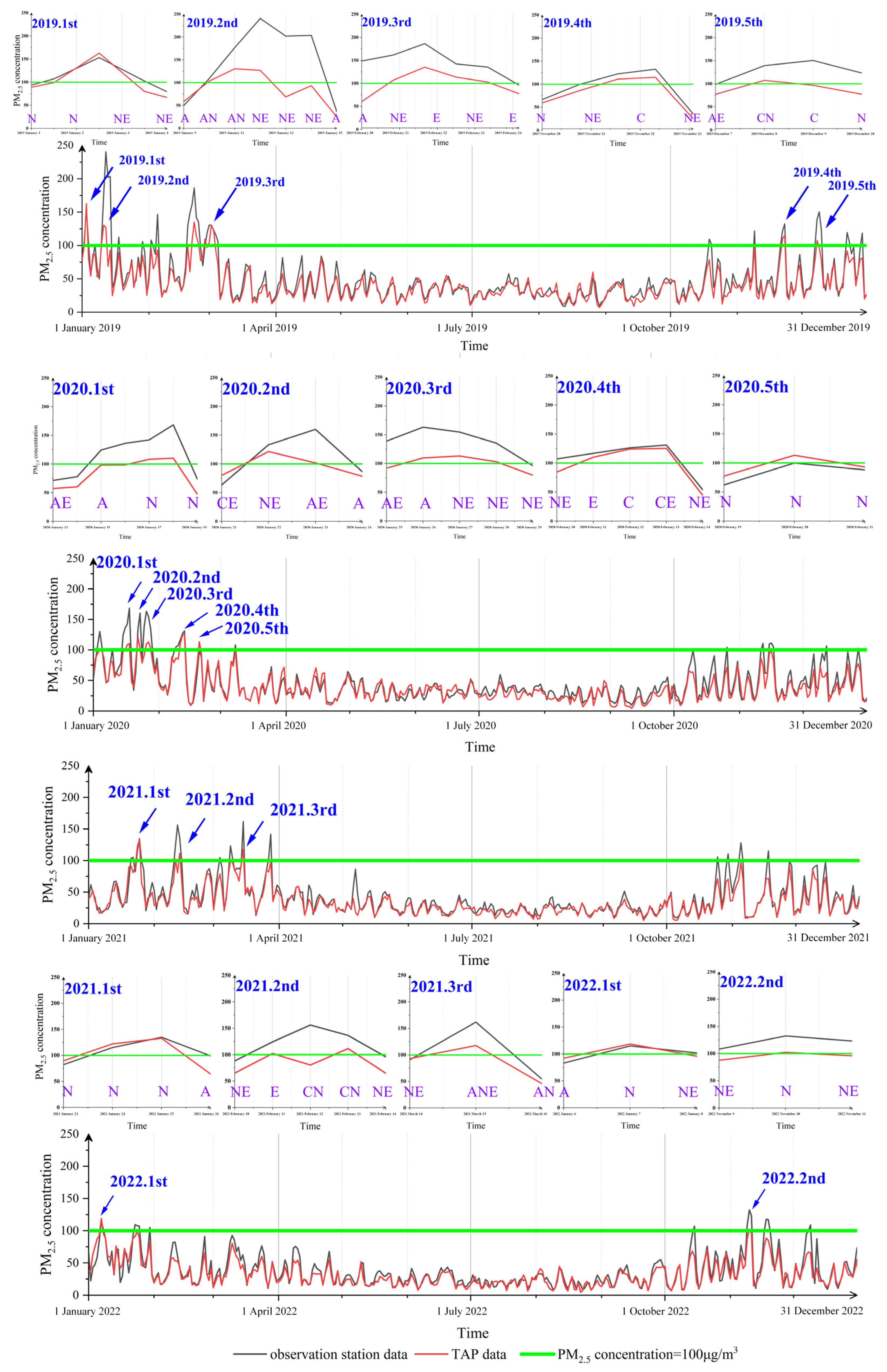
In 2019, the average daily PM2.5 concentration in the BTH region ranged from 7.04 μg/m3 to 162.98 μg/m3. The five pollution periods in the year were 1–4 January, 9–15 January, 20–24 February, 20–23 November, and 7–10 December. In 2020, the change range of PM2.5 average daily concentration in the study area was 4.23 μg/m3–125.26 μg/m3. Compared with the previous year, the average daily concentration decreased from 42.50 μg/m3 to 39.84 μg/m3, with a decrease proportion of 6.26%. Five pollution periods in the year occurred from 13 to 19 January, 21 to 24 January, 25 to 29 January, 10–14 February, and 19–21 February. In 2021, the average daily concentration of PM2.5 in the study area ranged from 5.31 μg/m3 to 132.91 μg/m3, with the pollutant concentration decreased by 14.73% compared with the previous year. Three pollution periods in the year occur from 23 to 26 January, 10 to 14 February, and 10 to 16 March. In 2022, the average daily concentration of PM2.5 in the BTH region ranged from 4.66 μg/m3 to 118.59 μg/m3, with pollutant concentration decreased by 5.54% compared with the previous year. The two pollution periods in the year occurred from 6 to 8 January and 9 to 11 November.
Atmospheric circulation types during the pollution period were statistically analyzed. Before the pollution period, atmospheric circulation types were mainly directional flow class, accounting for 70.59% (NE-type (northeast) and N-type (north) accounted for 23.53% respectively) and A-type (anticyclonic) accounted for 29.41%. In the pollution period, the directional flow class was the main atmospheric circulation type, accounting for 59.46%, and the NE-type accounted for 24.32%. After the pollution period, the proportion of other atmospheric circulation types increased, but the directional flow class was still dominant, with NE-type accounting for 43.75%. In general, atmospheric circulation types of the two pollution periods from 1 to 4 January 2019 and 25 to 29 January 2020 were relatively typical. This study chooses the first pollution event in 2019 during the non-COVID-19 epidemic period as a case for analysis from Figure 4.
A-type, N-type, and NE-type were the main atmospheric circulation types during the pollution period. Firstly, 15 January 2020 is selected as the typical day of A-type atmospheric circulation. The high-pressure belt was located in the east of the study area, the geopotential height line was loose, and the wind direction was north and low. A-type circulation mainly appeared in the early stage of the pollution period, which was easy to accumulate pollutants (see Figure 5a). Secondly, 20 February 2020 is selected as the typical day of the N-type atmospheric circulation. There was high pressure in the east, geopotential height line is relatively close, and westerly and northwest winds dominated. Moreover, the impact of mountain topography was conducive to the transmission of pollutants to the sea and the alleviation of pollution. This type of atmospheric circulation mostly appeared in the late pollution period, and pollutants accumulated in some periods due to wind speed, temperature, and precipitation (from Figure 5b). Thirdly, 11 January 2019 is selected as the typical day of NE-type atmospheric circulation. The high pressure was located in the east and westerly winds dominated, which was conducive to the transport of pollutants to the sea and the alleviation of atmospheric pollution (see Figure 5c).

3.3. A Case Study of Circulation Situation under the Pollution Period

Compared with the monitoring PM2.5 data in the same period, the PM2.5 concentration obtained from TAP data exceeded 100 μg/m3 in the BTH region on 2 January 2019, and reached the peak value of 163 μg/m3 on January 3 and dropped to 80 μg/m3 on 4 January. After the study period, the PM2.5 concentration exceeded the standard stipulated by the National Ambient Air Quality Standards (GB 3095-2012, grade II) [27], and this time was marked as a pollution event.
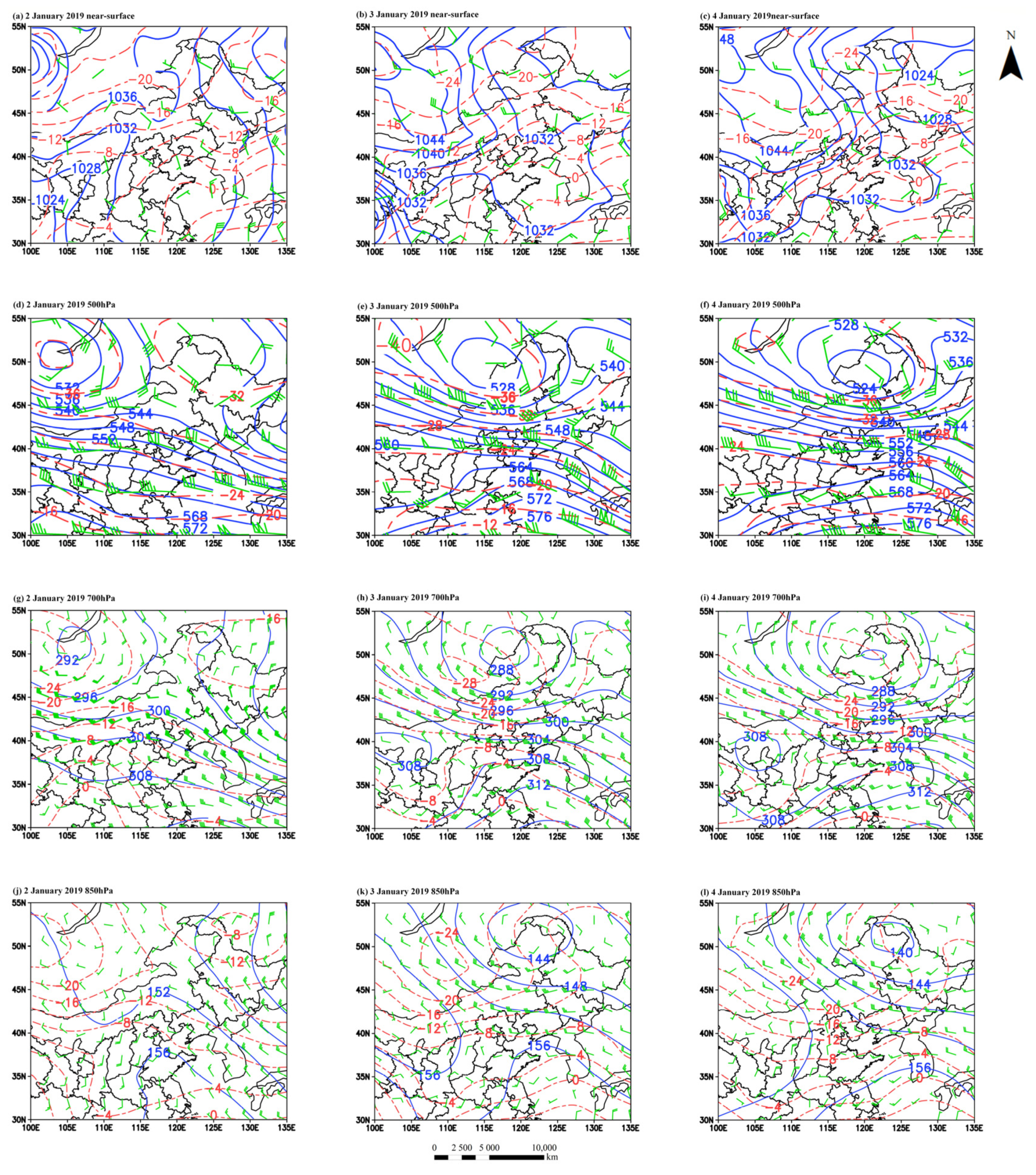
On 2 January, according to the Lamb-Jenkinson objective classification method results, it was N-type (north) circulation. Figure 6a reports the near-surface situation. Daily potential temperature field could be seen that temperature in the study area presents a decreased trend from the south to the north. Isobar became rare, and the wind field began to change into the north wind with low wind speed. As the BTH region was affected by the upper air flow eastward, the low-pressure trough had a weak influence on the whole and the air flow was relatively gentle, which was not conducive to the strong convergence of cold and warm air flows. The direction of air flow movement was not quickly moved south, but there was a tendency to change to the north wind. The barrier of Taihang Mountain was also one of the factors affecting the change of air flow. First of all, as seen in Figure 6d, there was significantly low-pressure center located in the southwest direction of Lake Baikal at 500 hPa. Low-pressure trough extended to Mongolia and the Inner Mongolia Province of China, but there was no obvious high-pressure center. Atmospheric pressure in most areas of China showed a law of decreasing from south to north. The isobar line in the northeast region is torsional, while the isobar surface in the other regions was regular. This pressure was the east wind in a whole region of China, and there was a tendency of southeast wind and northeast wind in some areas, and the wind speed difference was not obvious. Then, Figure 6g provided that there was still a low-pressure center in the south of Lake Baikal in Russia at 700 hPa, with sparse isobar lines and little difference in the shape of the isobar surface. It could be seen that the southeast wind in the BTH region was more obvious, the wind value was reduced, the airflow was relatively flat, and the atmospheric pressure was still increasing from north to south under the control of about three layers of isobar surface. Finally, there was no obvious low-pressure center within the range of 850 hPa as shown in Figure 6j. In conclusion, atmospheric circulation and weather patterns during this period were more prone to the accumulation of pollutants resulting in regional pollution, and there was a trend of positive change.
On January 3, according to atmospheric circulation classification results, it was NE-type (northeast) circulation. Figure 6b provides the near-surface high-pressure center was located in Inner Mongolia Province; the low-pressure center was located in Heilongjiang Province. BTH region was at the edge of the high-pressure belt and behind the cold front. At this time, the study area was affected by weak high pressure, with sparse isobars, gentle air flow, and weak wind. There was an obvious low-pressure center located at the junction of Inner Mongolia Province and Mongolia in this constant pressure field. The daily potential temperature field indicated that temperature had an upward trend conducive to the second conversion of PM2.5. Firstly, Figure 6e shows the trough of low pressure extended to the southeast of China, and isobars were relatively dense. The wind direction was mainly east and southeast with relatively high wind speed. The upper low-pressure center and high-pressure center were opposite to the near-surface pressure field due to the influence of airflow subsidence. Secondly, the low-pressure center still existed at 700 hPa and its position changed little, wind speed increased compared with the previous day, and the change of isobaric surface tended to be gentle. The weak high-pressure center appeared in the junction of Inner Mongolia, Gansu, and Ningxia Province, but the BTH region continued to be affected by the low-pressure trough, and the overall pressure change was larger than that in 500 hPa constant pressure field (see Figure 6h). Thirdly, Figure 6k shows the influence range of the low-pressure center had expanded significantly, extending to the Heilongjiang Province in 850 hPa. The central value was between 500 hPa and 700 hPa central value, but the range of the second gradient surface had increased significantly. The wind value had also expanded compared with the previous day with the change of wind direction. On this day, the near-surface pressure of the BTH region was mainly affected by the marine clean air mass in the eastern region and the cold air mass in the northern region. The wind speed increased, and the atmospheric pressure was relatively stable, which was conducive to the transport of pollutants to the outside and the entry of clean air from the sea, and the pollution of fine particles was alleviated.
On 4 January, there was still NE-type (northeast) circulation. Figure 6c provides the center of near-surface atmospheric pressure was located in the border zone between Xinjiang Province and Mongolia, and the center of low pressure was located in the southern part of Xinjiang Province. Under the influence of the pressure gradient force, the northwest wind from the Siberia area to the southeast coast of China was formed. The potential temperature field of the day showed that temperature in the southern part of the study area decreased and the temperature difference in the whole area narrowed. As seen from Figure 6f, the 500 hPa low-pressure center was located at the junction of Inner Mongolia and Heilongjiang Province, with strong wind, and was still dominated by the easterly wind in most areas. The isobars were also relatively dense, and the pressure gradient force was relatively large, which is significantly lower than the previous day’s pressure, and the low-pressure center also had an expanding trend. Figure 6i reports the 700 hPa low-pressure center was still located in Inner Mongolia Province, and the study area as a whole continued to be affected by the trough of low pressure, and the overall pressure change was larger than that of 500 hPa. The 850 hPa chart shows the isobaric line was becoming rarer and dominated by the southeast wind. The whole study area was almost within the same isobaric range. There was no obvious high-pressure center in the range shown in the figure, and the pressure was relatively stable from Figure 6l. In conclusion, the upper layer was dominated by southeast air flow, while the near-surface layer was dominated by northwest air-flow. The pollutant track height was low and the moving speed was fast, which was easy for the external transmission of pollutants.
In general, the study area was affected by an anticyclone for three days, and the wind direction rotated clockwise. The ridge of high pressure was located to the southwest of the study area and gradually moved to the northeast. The trough of low pressure gradually moved southward and divided into two parts in Inner Mongolia Province, one affecting the BTH region from northwest to southeast. Wind direction, including northeast wind and southeast wind, was easy to accumulate pollutants with northwest wind. This was easy to diffuse pollutants. The isobar was gradually tight, the wind is stronger, and the possibility of precipitation is increased.

3.4. A Case Study of Physical Parameter Field under the Pollution Period

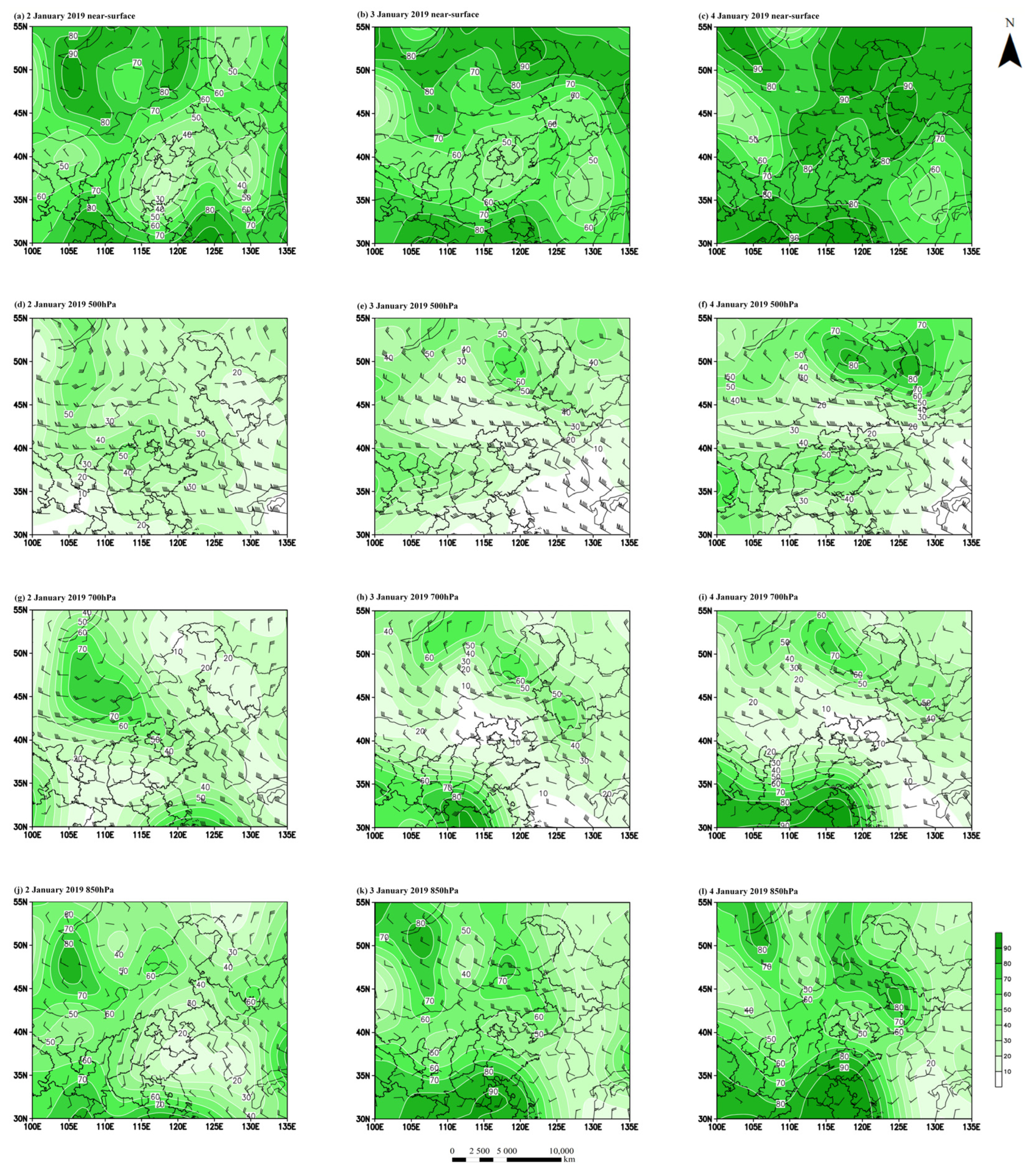
As seen in Figure 7a, the humidity in Northern China and northeasterly China was high on 2 January, and the study area was located at the edge of the near-surface low humidity center, so the overall humidity was low, and the influence of wind speed was also small. Firstly, Figure 6d shows 500 hPa wind speed increased significantly and wind shear existed. The center of high humidity was located in the northwest of the mountain, and the study area was within the range of high relative humidity. Secondly, Figure 7g provided wind speed continued to increase at 700 hPa and the southeast wind was more obvious. The two humidity centers were located in Zhejiang Province and Mongolia respectively, and the BTH region was in the influence area of the high humidity range of Mongolia. Thirdly, Figure 7j reports humidity center of 850 hPa was similar to that of 700 hPa and the range decreased. There was an oblique tangential increase from southeast to northwest, and the wind speed decreased accordingly. In general, compared with other surrounding provinces, the BTH region had low humidity and was affected by dry and cold air, with little wind speed, which was not conducive to the diffusion of pollutants.
As could be seen from the near-surface humidity map, relative humidity increased significantly on 3 January. Most of the study area was located in the center of low humidity. The increase in relative humidity was conducive to the deposition of atmospheric particles, and wind speed in the study area also increased (see Figure 7b). First of all, Figure 7e shows the center of high humidity was located in Inner Mongolia Province, where there was a convergence zone of southeast and northwest airflow in 500 hPa. Then, Figure 6h reports the 700 hPa high-pressure center was located in the middle reaches of the Yangtze River, and two small high humidity centers were formed in northeast China. BTH region was located in the junction of the two high-value regions, but in the low-value region. Finally, Figure 7k shows the plain of the middle and lower reaches of the Yangtze River, high-value area continued to expand, relative humidity in the study area increased and the wind speed decreased to 850 hPa. In a word, wind speed and humidity in the study area increased, which was conducive to the diffusion of pollutants.
As seen from Figure 7c, the near-surface humidity map provides the humidity in the study area continued to increase on 4 January, and wind speed also increased slightly. The center of high humidity was located in Inner Mongolia Province, and the northwestern part of the BTH region was located at the edge of the center of high humidity, which further facilitated the sedimentation effect of PM2.5 and alleviated air pollution. Firstly, Figure 7f shows the two centers of high humidity located in Inner Mongolia and Heilongjiang Province respectively. There was a weak center of high humidity in the south of the study area, and wind speed was lower than the previous day at 500 hPa. Secondly, Figure 7i provides 700 hPa has a high humidity center moved northward compared with the previous average day, and the study area was still in the middle of two high humidity centers. Thirdly, Figure 7l reports the humidity in the study area changed little compared with the previous day, and wind speed was relatively stable at 850 hPa. On the whole, relative humidity was the main influencing factor of the day, which was conducive to the further sedimentation of atmospheric particles and the reduction of pollution levels.

4. Discussion

From 2019 to 2022, PM2.5 concentration in the BTH region was higher in the heating season than in the non-heating season. The pollution period was concentrated in the heating season, and the frequency had decreased due to the lockdown policy of the COVID-19 epidemic period. Atmospheric circulation was mainly a directional flow class, especially NE-type circulation. In the study area, PM2.5 was easy to accumulate when the easterly wind was near the surface, the pressure field gradient was consistent with the wind field, relative humidity field and potential temperature field were low. Otherwise, PM2.5 concentration was easy to decrease. This result was consistent with previous research results [35,36,37]. Most of the previous studies analyzed the influence of the change of weather patterns on the transport of PM2.5 in a pollution period, but the summary of the regularity of atmospheric circulation characteristics and the analysis of the physical parameter field caused by pollution were lacking. In this paper, the influence of atmospheric circulation on the accumulation and diffusion of PM2.5 is analyzed by constructing the relationship between the Lamb-Jenkinson objective classification results and the weather pattern and other physical parameter fields before, during, and after the pollution period. The research results can provide a scientific basis for regional dynamic control of pollutant transmission paths and air pollution control, and realize the sustainable development of the atmospheric ecological environment.
PM2.5 is the primary atmospheric pollutant affecting most regions of China [38]. Atmospheric circulation is an important factor affecting PM2.5 transmission, which directly or indirectly affects the stability of the entire atmospheric ecosystem. Therefore, the results of this study can provide constructive suggestions for government decision-making departments. Firstly, the BTH region needs to take the opportunity of coordinated development to prevent and control atmospheric pollutants, further strengthen regional joint prevention and control, promote clean energy, strengthen supply-side structural reform, and optimize the capacity structure. Secondly, due to the influence of the NE-circulation and the blockage of the Taihang Mountains, it is convenient for PM2.5 to gather in the BTH region. Therefore, it is necessary to focus on reducing the number of polluting enterprises along the transmission path and increasing humidity in potential accumulation areas to facilitate pollutant deposition. Finally, it is necessary to improve the effective monitoring and forecasting methods combining atmospheric circulation and pollutants, so as to promote the long-term healthy development of industrial enterprises while safeguarding the blue sky.

5. Conclusions

The Lamb-Jenkinson objective classification method was used to study the changes in circulation classification at the beginning, middle, and end of the air pollution period. In addition, the influence of the physical parameter field on weather conditions was also considered. The results show that the spatiotemporal differentiation of atmospheric circulation is large. In the heating season (winter and spring), A-type, N-type, and NE-type were the main circulations. However, in the non-heating season (summer and autumn), the occurrence times of C-type circulation were significantly increased, and some atmospheric circulation types were less. Additionally, there were 15 pollution periods from 2019 to 2022. Additionally, the pollution periods were mostly influenced by directional flow class circulations. Before the pollution process, they were mainly influenced by the A-type, NE-type, and N-type atmospheric circulations. During the pollution process, they were most affected by the NE-type and N-type atmospheric circulations and influenced by the NE-type circulation after the pollution process. Additionally, then, research on the pollution period and the atmospheric pressure ladder difference was expanded continuously. That resulted in an increase in wind speed and was influenced by terrain and wind direction factors. The upper atmospheric pressure provided an opposite trend to that near the ground, from the easy accumulation of pollutants to conducive to the diffusion of PM2.5. Finally, in the physical parameter field of the pollution event, the humidity in the region increased continuously, from 40% to 80%, which was easy to deposit pollutants. The relative humidity field in the upper air showed a basically opposite trend to that on the ground. Moreover, the potential temperature field tended to decrease but remained stable on the whole, which was easy to decrease the concentration of atmospheric pollutants continuously.

Author Contributions

Writing—original draft, S.G.; methodology, S.W.; software, L.Y. and B.Z.; writing—review & editing, funding acquisition, Y.H.; formal analysis, visualization, B.T.; writing—review & editing, Y.Y.; data curation, N.M. and P.J. All authors have read and agreed to the published version of the manuscript.

Funding

This work was supported by Shijiazhuang Science and Technology Plan Project (grant number 221790441).

Institutional Review Board Statement

Not applicable.

Informed Consent Statement

Not applicable.

Data Availability Statement

Research data from this study will be made available on request ([email protected]).

Conflicts of Interest

The authors declare to no conflict of interest.

References

  1. Liao, Z.; Gao, M.; Sun, J.; Fan, S. The Impact of Synoptic Circulation on Air Quality and Pollution-Related Human Health in the Yangtze River Delta Region. Sci. Total Environ. 2017, 607, 838–846. [Google Scholar] [CrossRef]
  2. Sun, Z.; Han, L.; Ding, A.; Liu, H.; Zhao, X. The Health Impacts of Aerosol-Planetary Boundary Layer Interactions on Respiratory and Circulatory Mortality. Atmos. Environ. 2022, 276, 119050. [Google Scholar] [CrossRef]
  3. Liu, S.; Yang, X.; Duan, F.; Zhao, W. Changes in Air Quality and Drivers for the Heavy PM2.5 Pollution on the North China Plain Pre- to Post-COVID-19. Int. J. Environ. Res. Public Health 2022, 19, 12904. [Google Scholar] [CrossRef]
  4. Yang, J.; Fu, X.; Qiao, L.; Yao, L.; Zhang, F.; Li, W. Characteristics of Atmospheric Pollution in a Chinese Megacity: Insights from Three Different Functional Areas. Sustainability 2023, 15, 2429. [Google Scholar] [CrossRef]
  5. Wang, S.; Gao, J.; Guo, L.; Nie, X.; Xiao, X. Meteorological Influences on Spatiotemporal Variation of PM2.5 Concentrations in Atmospheric Pollution Transmission Channel Cities of the Beijing–Tianjin–Hebei Region, China. Int. J. Environ. Res. Public Health 2022, 19, 1607. [Google Scholar] [CrossRef]
  6. Yu, Y.; Xu, H.; Jiang, Y.; Chen, F.; Cui, X.; He, J.; Liu, D. A Modeling Study of PM2.5 Transboundary Transport during a Winter Severe Haze Episode in Southern Yangtze River Delta, China. Atmos. Res. 2021, 248, 105159. [Google Scholar] [CrossRef]
  7. Guan, Y.; Xiao, Y.; Rong, B.; Zhang, N.; Chu, C. Long-Term Health Impacts Attributable to PM2.(5) and Ozone Pollution in China’s Most Polluted Region during 2015–2020. J. Clean Prod. 2021, 321, 128970. [Google Scholar] [CrossRef]
  8. Zhang, H.; Wang, Y.; Park, T.-W.; Deng, Y. Quantifying the Relationship between Extreme Air Pollution Events and Extreme Weather Events. Atmos. Res. 2017, 188, 64–79. [Google Scholar] [CrossRef]
  9. Tran, H.N.Q.; Moelders, N. Investigations on Meteorological Conditions for Elevated PM2.5 in Fairbanks, Alaska. Atmos. Res. 2011, 99, 39–49. [Google Scholar] [CrossRef]
  10. Feng, R.; Gao, H.; Luo, K.; Fan, J. Analysis and Accurate Prediction of Ambient PM2.5 in China Using Multi-Layer Perceptron. Atmos. Environ. 2020, 232, 117534. [Google Scholar] [CrossRef]
  11. Cao, B.; Yin, Z. Future Atmospheric Circulations Benefit Ozone Pollution Control in Beijing-Tianjin-Hebei with Global Warming. Sci. Total Environ. 2020, 743, 140645. [Google Scholar] [CrossRef]
  12. Zheng, Z.; Dong, W.; Yan, D.; Guo, Y.; Wei, Z.; Chou, J.; Zhu, X.; Wen, X. Relative Contributions of Urbanization and Greenhouse Gases Concentration on Future Climate over Beijing-Tianjin-Hebei Region in China. Clim. Dyn. 2022, 58, 1085–1105. [Google Scholar] [CrossRef]
  13. Bei, N.; Zhao, L.; Xiao, B.; Meng, N.; Feng, T. Impacts of Local Circulations on the Wintertime Air Pollution in the Guanzhong Basin, China. Sci. Total Environ. 2017, 592, 373–390. [Google Scholar] [CrossRef]
  14. Flocas, H.; Kelessis, A.; Helmis, C.; Petrakakis, M.; Zoumakis, M.; Pappas, K. Synoptic and Local Scale Atmospheric Circulation Associated with Air Pollution Episodes in an Urban Mediterranean Area. Theor. Appl. Climatol. 2009, 95, 265–277. [Google Scholar] [CrossRef]
  15. Compagnucci, R.H.; Richman, M.B. Can Principal Component Analysis Provide Atmospheric Circulation or Teleconnection Patterns? Int. J. Climatol. 2008, 28, 703–726. [Google Scholar] [CrossRef]
  16. Huth, R.; Beck, C.; Philipp, A.; Demuzere, M.; Ustrnul, Z.; Cahynova, M.; Kysely, J.; Tveito, O.E. Classifications of Atmospheric Circulation Patterns Recent Advances and Applications. In Trends and Directions in Climate Research; Gimeno, L., GarciaHerrera, R., Trigo, R.M., Eds.; Wiley-Blackwell: Hoboken, NJ, USA, 2008; Volume 1146, pp. 105–152. ISBN 978-1-57331-732-0. [Google Scholar]
  17. Wang, T.; Du, H.; Cheng, W.; Zhao, Z.; Zhang, J.; Zhou, C. Influence of Meteorological Conditions on the Air Quality during the 2022 Winter Olympics in Beijing. Front. Environ. Sci. 2022, 10, 987272. [Google Scholar] [CrossRef]
  18. Liao, W.; Wu, L.; Zhou, S.; Wang, X.; Chen, D. Impact of Synoptic Weather Types on Ground-Level Ozone Concentrations in Guangzhou, China. Asia-Pac. J. Atmos. Sci. 2021, 57, 169–180. [Google Scholar] [CrossRef]
  19. Tang, L.; Karlsson, P.E.; Gu, Y.; Chen, D.; Grennfelt, P. Synoptic Weather Types and Long-Range Transport Patterns for Ozone Precursors during High-Ozone Events in Southern Sweden. Ambio 2009, 38, 459–464. [Google Scholar] [CrossRef]
  20. Chen, X.; Wang, N.; Wang, G.; Wang, Z.; Chen, H.; Cheng, C.; Li, M.; Zheng, L.; Wu, L.; Zhang, Q.; et al. The Influence of Synoptic Weather Patterns on Spatiotemporal Characteristics of Ozone Pollution Across Pearl River Delta of Southern China. J. Geophys. Res.-Atmos. 2022, 127, e2022JD037121. [Google Scholar] [CrossRef]
  21. Fan, L.; Yan, Z.; Chen, D.; Fu, C. Comparison between Two Statistical Downscaling Methods for Summer Daily Rainfall in Chongqing, China. Int. J. Climatol. 2015, 35, 3781–3797. [Google Scholar] [CrossRef]
  22. Liu, J.; Wang, L.; Li, M.; Liao, Z.; Sun, Y.; Song, T.; Gao, W.; Wang, Y.; Li, Y.; Ji, D.; et al. Quantifying the Impact of Synoptic Circulation Patterns on Ozone Variability in Northern China from April to October 2013–2017. Atmos. Chem. Phys. 2019, 19, 14477–14492. [Google Scholar] [CrossRef]
  23. Zheng, L.; Chen, W.; Jia, S.; Wu, L.; Zhong, B.; Liao, W.; Chang, M.; Wang, W.; Wang, X. Temporal and Spatial Patterns of Nitrogen Wet Deposition in Different Weather Types in the Pearl River Delta (PRD), China. Sci. Total Environ. 2020, 740, 139936. [Google Scholar] [CrossRef]
  24. Lamb, H. British Isles Weather Types and a Register of the Daily Sequence of Circulation Patterns. In Geophysical Memoirs; H.M. Stationery Office: London, UK, 1972; Volume 116. [Google Scholar]
  25. Li, M.; Wang, L.; Liu, J.; Gao, W.; Song, T.; Sun, Y.; Li, L.; Li, X.; Wang, Y.; Liu, L.; et al. Exploring the Regional Pollution Characteristics and Meteorological Formation Mechanism of PM2.5 in North China during 2013-2017. Environ. Int. 2020, 134, 105283. [Google Scholar] [CrossRef]
  26. Yan, Y.; Zhou, Y.; Kong, S.; Lin, J.; Wu, J.; Zheng, H.; Zhang, Z.; Song, A.; Bai, Y.; Ling, Z.; et al. Effectiveness of Emission Control in Reducing PM2.5 Pollution in Central China during Winter Haze Episodes under Various Potential Synoptic Controls. Atmos. Chem. Phys. 2021, 21, 3143–3162. [Google Scholar] [CrossRef]
  27. Hu, J.; Li, N.; Zou, S.; Yoshino, H.; Yanagi, U.; Yu, C.W.; Qu, H. Indoor Environmental Conditions in Schoolchildren’s Homes in Central-South China. Indoor Built Environ. 2020, 29, 956–971. [Google Scholar] [CrossRef]
  28. Xu, K.; Chi, Y.; Wang, J.; Ge, R.; Wang, X. Analysis of the Spatial Characteristics and Driving Forces Determining Ecosystem Quality of the Beijing-Tianjin-Hebei Region. Environ. Sci. Pollut. Res. 2021, 28, 12555–12565. [Google Scholar] [CrossRef]
  29. Jiang, C.; Wang, H.; Zhao, T.; Li, T.; Che, H. Modeling Study of PM2.5 Pollutant Transport across Cities in China’s Jing-Jin-Ji Region during a Severe Haze Episode in December 2013. Atmos. Chem. Phys. 2015, 15, 5803–5814. [Google Scholar] [CrossRef]
  30. Xiao, Q.; Geng, G.; Cheng, J.; Liang, F.; Li, R.; Meng, X.; Xue, T.; Huang, X.; Kan, H.; Zhang, Q.; et al. Evaluation of Gap-Filling Approaches in Satellite-Based Daily PM2.5 Prediction Models. Atmos. Environ. 2021, 244, 117921. [Google Scholar] [CrossRef]
  31. Geng, G.; Xiao, Q.; Liu, S.; Liu, X.; Cheng, J.; Zheng, Y.; Xue, T.; Tong, D.; Zheng, B.; Peng, Y.; et al. Tracking Air Pollution in China: Near Real-Time PM2.5 Retrievals from Multisource Data Fusion. Environ. Sci. Technol. 2021, 55, 12106–12115. [Google Scholar] [CrossRef]
  32. Xiao, Q.; Geng, G.; Xue, T.; Liu, S.; Cai, C.; He, K.; Zhang, Q. Tracking PM2.5 and O-3 Pollution and the Related Health Burden in China 2013-2020. Environ. Sci. Technol. 2022, 56, 6922–6932. [Google Scholar] [CrossRef]
  33. Xiao, Q.; Zheng, Y.; Geng, G.; Chen, C.; Huang, X.; Che, H.; Zhang, X.; He, K.; Zhang, Q. Separating Emission and Meteorological Contributions to Long-Term PM2.5 Trends over Eastern China during 2000–2018. Atmos. Chem. Phys. 2021, 21, 9475–9496. [Google Scholar] [CrossRef]
  34. Yi, Z.; Wang, Y.; Chen, W.; Guo, B.; Zhang, B.; Che, H.; Zhang, X. Classification of the Circulation Patterns Related to Strong Dust Weather in China Using a Combination of the Lamb-Jenkinson and k-Means Clustering Methods. Atmosphere 2021, 12, 1545. [Google Scholar] [CrossRef]
  35. Li, J.; Liao, H.; Hu, J.; Li, N. Severe Particulate Pollution Days in China during 2013-2018 and the Associated Typical Weather Patterns in Beijing-Tianjin-Hebei and the Yangtze River Delta Regions. Environ. Pollut. 2019, 248, 74–81. [Google Scholar] [CrossRef] [PubMed]
  36. Wang, X.; Zhang, R. Effects of Atmospheric Circulations on the Interannual Variation in PM2.5 Concentrations over the Beijing-Tianjin-Hebei Region in 2013-2018. Atmos. Chem. Phys. 2020, 20, 7667–7682. [Google Scholar] [CrossRef]
  37. Yin, Z.; Li, Y.; Zhang, Y.; Wang, H. Evident Differences of Haze Days between December and January in North China and Possible Relationships with Preceding Climate Factors. Int. J. Climatol. 2023, 43, 438–455. [Google Scholar] [CrossRef]
  38. Wang, Y.; Duan, X.; Liang, T.; Wang, L.; Wang, L. Analysis of Spatio-Temporal Distribution Characteristics and Socioeconomic Drivers of Urban Air Quality in China. Chemosphere 2022, 291, 132799. [Google Scholar] [CrossRef]
Figure 1. Study area profile (a) BTH regional elevation and (b) the overview of BTH regional land use situation.
Atmosphere 14 00942 g001
Figure 2. Two layers of grid points nested influence regions. p n is grid point, O represents center point and O1, O2 are center points at the same longitude as point O.
Atmosphere 14 00942 g002
Figure 3. Significance test analysis results of TAP data and monitoring PM2.5 data.
Atmosphere 14 00942 g003
Figure 4. Changes in PM2.5 concentration from 2019 to 2022 (the enlarged figure reflects the change of pollutant concentration in each pollution period; the purple text represents the classification results of atmospheric circulation on that day; the black line represents the monitoring PM2.5 data; the red line represents TAP data; and the green line represents the PM2.5 concentration of 100 μg/m3, which is the standard value in the pollution period).
Atmosphere 14 00942 g004
Figure 5. Major atmospheric circulation types correspond to synoptic weather patterns (the background color is the near-surface pressure; the black line represents geopotential height; the arrows are wind field information). (ac) represent typical pollution daily synoptic weather patterns of A- type, N-type, and NE-type, respectively.
Atmosphere 14 00942 g005
Figure 6. Changes of mean potential temperature field and sea level pressure field from 2 to 4 January (the blue lines represent atmospheric pressure; the red lines represent 2 m near-surface temperature and the green lines represent wind field information, including wind speed and wind direction). (ac), (df), (gi) and (jl) represent meteorological field near-surface, 500 hPa, 700 hPa and 850 hPa from 2–4 January 2019, respectively.
Atmosphere 14 00942 g006
Figure 7. Trends of mean humidity field from 2 to 4 January (the green background represents the humidity value). (ac), (df), (gi) and (jl) represent mean humidity field near-surface, 500 hPa, 700 hPa and 850 hPa from 2–4 January 2019, respectively.
Atmosphere 14 00942 g007
Table 1. Circulation types based on the Lamb-Jenkinson objective classification scheme.
ξ V
(Directional Flow Class)
ξ 2 V
(Rotational Flow Class)
V < ξ < 2 V
(Mixed Class)
V < 6 and
ξ < 6
(Undefined)
N(north),NE(northeast)
E(east),SE(southeast)
S(south),SW(southwest)
W(west),NW(northwest)
A(anticyclonic),
C(cyclonic)
ANE(anticyclonic northeast),
CNE(cyclonic northeast)
UD(Undefined)
Table 2. Frequency of each atmospheric circulation type scheme.
Type (Day)JanFebMarAprMayJunJulAugSepOctNovDec
A242324148531630382234
AE601401313244
AN141288443610121425
ANE171034217211089
C43148162627199554
CE011464513200
CN38414141617144353
CNE0453711561220
E61212121210810111065
N292531344630213536273427
NE21142115912251412132013
Disclaimer/Publisher’s Note: The statements, opinions and data contained in all publications are solely those of the individual author(s) and contributor(s) and not of MDPI and/or the editor(s). MDPI and/or the editor(s) disclaim responsibility for any injury to people or property resulting from any ideas, methods, instructions or products referred to in the content.