Article

Analysis of Precipitation Process and Operational Precipitation Enhancement in Panxi Region Based on Cloud Parameters Retrievals from China’s Next−Generation Geostationary Meteorological Satellite FY−4A

1
Weather Modification Office of Sichuan Province, Chengdu 610072, China
2
Heavy Rain and Drought-Flood Disasters in Plateau and Basin Key Laboratory of Sichuan Province, Chengdu 610072, China
3
China Meteorological Administration Cloud-Precipitation Physics and Weather Modification Key Laboratory, Beijing 100081, China
4
Department of Meteorology and Atmospheric Science, The Pennsylvania State University, University Park, State College, PA 16802, USA
*
Author to whom correspondence should be addressed.
Atmosphere 2023, 14(6), 922; https://doi.org/10.3390/atmos14060922
Submission received: 29 December 2022 / Revised: 3 April 2023 / Accepted: 12 May 2023 / Published: 25 May 2023
(This article belongs to the Section Meteorology)

Abstract

:
Geostationary meteorological satellite data with high spatial and temporal resolution can be used to retrieve cloud physical parameters, which has significant advantages in tracking cloud evolution and development. Based on satellite multispectral RGB composite image and cloud physical analysis methods, we quantitatively analyze the evolution characteristics of cloud parameters in the pre-, mid- and post-artificially influenced weather process, explore the application potential benefits of satellite data in monitoring the operating conditions of the artificially influenced weather in the Panxi region, and verify the feasibility analysis of the evaluation of their effects. In this study, cloud parameters such as cloud particle effective radius (Re), cloud liquid water path (LWP), cloud ice water path (IWP), and cloud top height and temperature (CTH and CTT) are retrieved using FY−4A satellite data. For the Panxi region, the evolution characteristics of typical cloud parameters in the affected area before and after two aircraft artificial operational precipitation enhancements are analyzed. The results show that the satellite retrieval of cloud characteristic parameters in the Panxi region has good application value, which can be used to guide the artificial Operational Precipitation Enhancement. In this precipitation process, there are solid particles in the upper layer cloud and supercooled water in the lower layer cloud. After the cold cloud catalysis, the cloud top height, liquid water and ice water content, particle effective radius and ground precipitation in the operational area increased, and the cloud top temperature decreased. Thus, it effectively alleviated the drought in the Panxi region. The satellite retrieval of cloud characteristic parameters in the Panxi region has a good application value, which can provide a basis and guidance for future weather modification operations in the Panxi region.

1. Introduction

As China’s modernization progresses steadily and the demand for ensuring the safety of people’s production and life increases, higher demands are placed on the ability of meteorological disaster prevention and reduction [1,2]. Artificial rainfall, as one of the means of drought and disaster relief, has developed rapidly in China. Due to the complex and variable nature of the cloud precipitation process, using cloud detection technology to understand cloud conditions, identify suitable targets for catalytic operations, and track their evolution is of practical significance for the scientificity of operations and improving their effectiveness [3,4]. The object of operational rainfall enhancement is clouds into which a catalyst is seeded, and it is important to select a cloud system that is suitable for catalysis. Although precipitation comes from clouds, the presence of clouds does not always result in precipitation. Prior to operational precipitation enhancement, cloud parameters such as cloud top height, cloud top temperature, cloud particle effective radius, liquid water and ice water paths of the target cloud system must be analyzed to determine if they are suitable for operational precipitation enhancement [5,6,7]. Therefore, in order to carry out operational rainfall enhancement in a more reasonable way, it is important to study cloud characteristics by using high spatial and temporal resolution satellite data to carry out the assessment of technical indicators such as airborne cloud water resources development and monitoring and forecasting of conditions for artificially influenced weather operations.
At present, ground-based and aircraft observations are widely used around the world to obtain microphysical characteristics of clouds to study the possible evolutionary trends of clouds, which are widely used in weather modification operations. Recent attempts to evaluate cloud seeding include coherent Doppler wind lidar, satellite, weather radar, and disdrometer [8,9]. Yang investigates the response of mixed-phase cloud microphysical properties to cloud seeding near the cloud top with an aircraft observation during the cloud-seeding period [10]. Liu and Wu used cloud radar data to conduct a preliminary statistical analysis of the daily variation of cloud top and bottom height, cloud thickness, cloud volume, and cloud layer number in summer clouds in the Nagqu region, successfully obtaining cloud observations from multiple radars for the first time [11,12]. Dong used the meteorological aircraft to obtain the microphysical properties of a two-layer stratus cloud [13].
Over the past decade, with the launch of geostationary meteorological satellites, satellite data have been further applied to theoretical research and technology development such as the development of airborne cloud water resources for artificially influenced weather and the monitoring and forecasting of artificially influenced weather operating conditions [1,7,14]. Compared with aircraft and ground-based radars, satellites have the advantages of long-range, multi-channel, multi-time, and convenient data acquisition, etc. Through multi-spectral data inverse performance of a variety of cloud characteristic parameters, such as cloud optical thickness, effective radius, cloud top temperature, liquid water path, etc., we can analyze cloud macro and microphysical characteristics, judge the cloud system movement, and track the evolution and development of the cloud system. It is one of the very effective tools to carry out artificial rainfall operations. It has provided scientific guidance for selecting the timing and area of artificial rainfall operation. Researchers have verified and compared the cloud parameters obtained from satellites and conducted a series of application studies [15,16]. For example, various atmospheric parameters have been quantified from data of the 10.7 μm and 6.7 μm window data using satellite observations [17]. Cloudsat data were used to analyze the vertical structural differences between precipitating and non-precipitating clouds over Northeast China, and most of the precipitating clouds were found to be low, cold, ice or mixed-phase nimbostratus [18]. MODIS-retrieved cloud properties are used to identify cloud regions containing supercooled liquid water [5,19]. Lensky and Rosenfeld used the METEOSAT second geostationary satellite data to track the evolution of cloud top temperature (CTT) and particle effective radius (Re) of convective cloud [20]. With combined SNPP/VIIRS satellite data and meteorological gridded data, Yue et al. made it possible to retrieve a new class of convective cloud properties, which is used to retrieve for each pixel its temperature (T) and cloud drop effective radius (Re) [21]. Rosenfeld et al. used SNPP/VIIRS satellite retrievals to provide an estimation of cloud condensation nuclei (CCN) concentration NCCN from satellite measurements [22]. Rosenfeld et al. also retrieved drop concentration and CCN at convective cloud base using both satellite and radar [23]. The successful launch of the FY-4 meteorological satellite in 2016 provided new opportunities for the reversal of cloud microphysical properties. The FY−4A is the new generation of China’s Geosynchronous meteorological satellite, accessing more spectral channels, faster imaging and higher spatial resolution, including atmosphere, clouds, dust, and a variety of products [24,25,26]. The FY−4A has a stronger monitoring capability for medium-and small-scale weather systems. It can not only monitor the cloud development trend and track the evolution of the cloud but also guide aircraft and ground cloud-seeding operations to further determine the area and timing of catalytic operations. Li et al. observe the global observation of cloud top height by FY−4A and HIMAWARI-8 [27]. Jiang et al. obtain a cloud classification method based on a convolutional neural network for FY−4A Satellites [25].
The PanXi region, located in the south of Sichuan Province, is an important distribution area for forest resources in China. The climate in this region is hot and dry with little rain. Due to the high temperature, little rain and dry air, every winter and spring there are different degrees of drought due to low precipitation, and the forest fire risk level is constantly high, especially from February to May every year, which is the high season of forest fires [28]. The frequent occurrence of forest fires on the Panxi Plateau causes more casualties and damage to forest resources, and the amount of rainfall and hail protection services needed to increase food production is large, so there is a great demand for artificial weather operations. However, aircraft and ground-based equipment for detecting cloud physics are expensive, complicated to maintain and calibrate, and less widely used in the highlands, where observation stations are scarce [29]. Therefore, the applicability of satellite data is higher in the Panxi plateau, and if the inversion of satellite parameters is good, it can better guide the local artificial weather operations. At the same time, there is very little research on the application of satellite data in the Panxi region, especially in artificial weather operations, so it is of great significance to conduct research on the application potential of FY−4A satellite data in determining the operating conditions for aircraft rainfall augmentation operations in the Panxi region.

2. Data and Methods

2.1. Data

The data used in this paper consist of two parts: information from the FY−4A geostationary satellite L−2 products provided (L2) by the National Satellite Meteorological Centre, and the hourly observational data and sounding data from national meteorological stations. The satellite data include cloud parameters such as cloud particle effective radius, cloud liquid water path, cloud top height and temperature, while the station data include observational data of meteorological elements such as precipitation, temperature and relative humidity. The station sites for the hourly observation data include Butuo, Jinyang and Xichang in the Panxi region. The sounding data are the L−band sounding data from Xichang sounding station taken on 28 April and 4 May 2021 at 08:00.

2.2. Multispectral Analysis Method with RGB Composite Image

The combination of FY−4A multichannel information can reveal the cloud type, cloud top particle phase, particle effective radius, etc. The visible (0.65 or 0.72 μm) reflects the cloud’s optical thickness, the mid-infrared (3.7 μm) reflects the cloud particles’ effective radius of the cloud top (particle size) and the infrared (10.8 or 12.0 μm) reflects the cloud top temperature (warm or cold or high or low conditions) [30]. If the visible reflectance is assigned to red (the redder the hue the thicker the cloud), the 3.7 μm reflectance to green (the greener the hue R, the smaller the cloud), and the 10.8 μm light temperature to blue (the bluer the hue, the higher the temperature), then a true colour map of the combination of the 3 base colours red (R), green (G) and blue (B) can be used to visualise the physical characteristics of the cloud and analyse its evolution [20]. For example, using the 3.7 μm channel to identify the phase state of clouds, ice is twice as absorbent as water, ice clouds at the same temperature are less reflective than water clouds and the inverse Re is much larger, hence the bright red colour of ice clouds. When the temperature for supercooled water is below 0 °C, thick supercooled water clouds appear bright yellow on the RGB composite image [31].

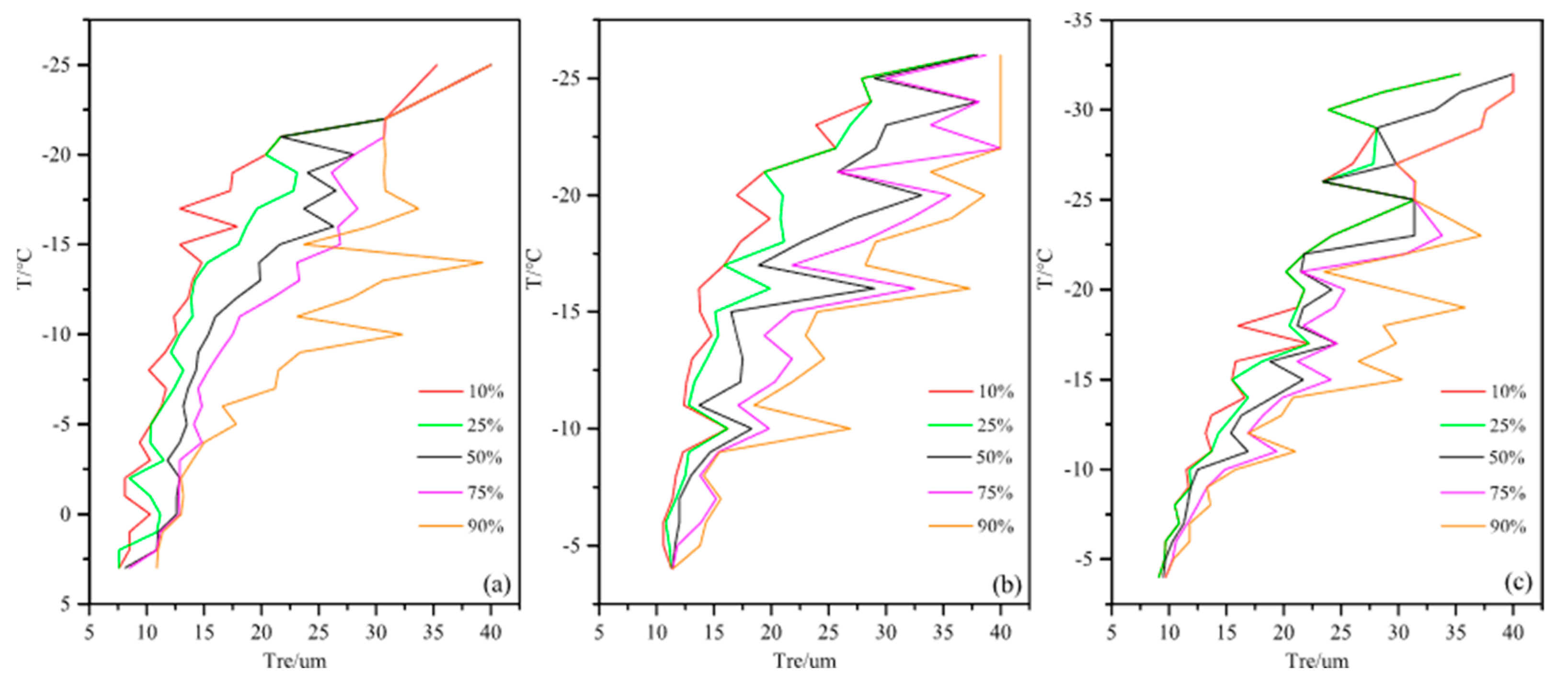
2.3. Cloud Microphysical Characteristics Analysis Based on T−Re Contours

Satellite observations can only provide information from the cloud top. In order to understand the conditions inside the cloud, Rosenfeld and Lensky [20,30] proposed a cloud microphysical analysis method based on satellite reversal technology, that is, the temperature (T) and particle effective radius (Re) at the cloud top at different development heights within a certain area are used approximately to replace T and Re at different development heights inside the cloud cluster. Thus, this gives the variation curve of Re with T within the cloud cluster in that area, i.e., the T−Re profile. Cloud droplets grow continuously as the airflow increases. T-Re can be used to express the growth rate of cloud particles and applied to the analysis of cloud physical processes to calculate the particle effective radius of cloud pixels, count the cloud pixels in the area every 1 °C, and then sort the particle effective radius from small to large. Draw the T-Re diagram according to the Re value corresponding to the percentage of samples (10%, 25%, 50%, 75%, 90%).

2.4. Analysis of Satellite Retrieval Products

Cloud top height and temperature are important macroscopic characteristics of clouds the selection of artificial rainfall augmentation catalysts and operational altitude layers. Cloud top height helps to understand the development degree and evolution trend of cloud systems, while cloud top temperature can be used to understand cold and warm clouds and ice-phase precipitation effects, both of which have important implications. Using the L2 level cloud products released by the National Meteorological Satellite Centre, the parameters such as particle effective radius, liquid water path, ice water path, cloud top height, cloud top temperature, etc. are selected. The weighted average of each grid point is carried out in a certain period to obtain the characteristic distribution of typical cloud parameters in the Panxi region, which is applied to the early weather background analysis. For the area affected by aircraft operations, the characteristic values of cloud parameters in the area affected by aircraft operations are obtained by weighted averaging between each grid point in a given area.

3. Weather Background and Aircraft Operation Description

3.1. Analysis of Weather Background

Since the beginning of winter, most areas in Sichuan, especially the western Sichuan Plateau and the Panxi region, have had less precipitation than usual. The temperature is higher than the same period in previous years. The weather is mainly cloudy to sunny, and the air is dry. Due to the continuous high temperature and low humidity weather, the Panxi region has been experiencing consecutive droughts, and the forest fire risk is on the high side, which has a great impact on agricultural production, forest fire prevention and social life. Figure 1a,b shows the average distribution of cloud parameter characteristics in April 2021. The figure shows that the cloud water content over Sichuan Basin is sufficient, with the liquid water and ice water contents mostly above 700 g/m2 and 900 g/m2. The cloud water content over the Panxi region is obviously lower, with dark blue colour blocks in most areas. The liquid water and ice water contents are around 200 g/m2 and 250 g/m2, with a maximum is 600 g/m2 and 800 g/m2 respectively. Combined with the daily variation characteristics of precipitation, relative humidity and temperature in Panxi region (Figure 1c), there is a precipitation process before and after 7 April, with an average daily precipitation of 4 mm and a temperature below 15 °C. After 9 April, there is no significant precipitation in the Panxi region. The relative humidity is also low, and the minimum value could reach 40%. The temperature is stable at around 16 °C in the early stages and then begins to rise significantly on 19 April, reaching the maximum value of 24 °C. By the 26th, the drought in the Panxi region is widespread. Most areas have moved from severe drought to extreme drought, and the forest fire danger level has reached high danger.

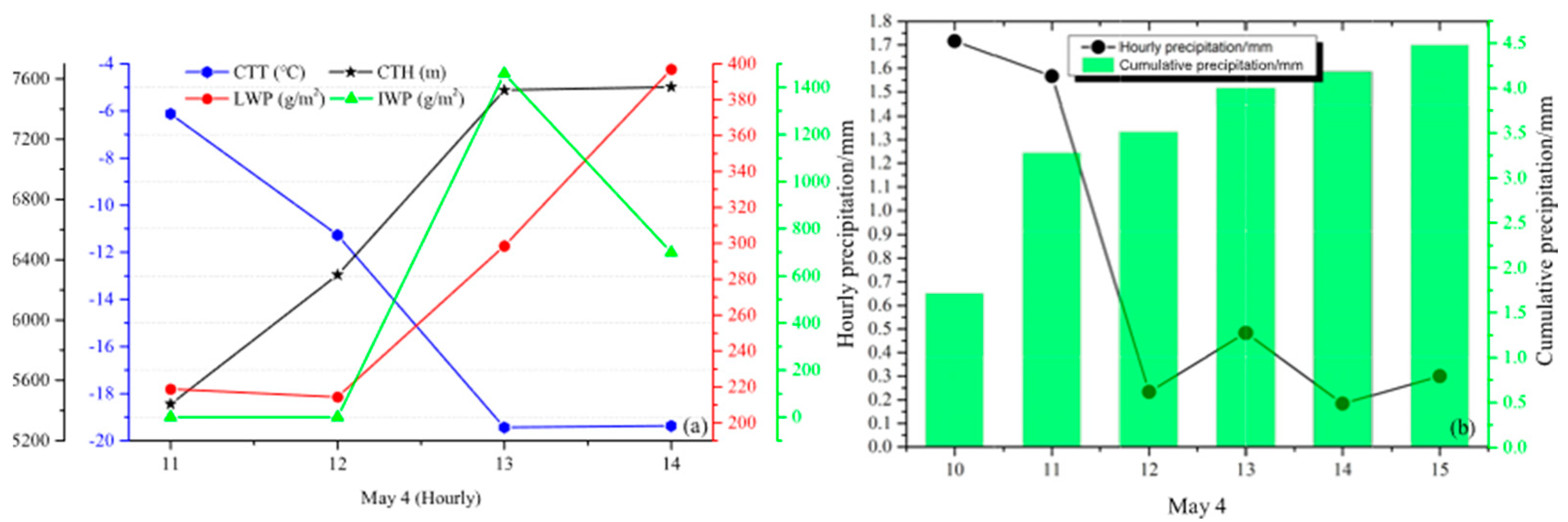
3.2. Aircraft Operation

According to the forecast, there will be a continuous precipitation process in the Panxi region from 28 April to 8 May. For this precipitation process, the Weather Modification Office of Sichuan Province is organising and implementing three operational precipitation enhancements by aircraft. The operational aircraft is Xiayan B−3625, and the operational area is Liangshan Prefecture in Panxi region. The first operation was carried out on 28 April 2021. The flight time is 10:40~13:15, and the seeding time was 11:20~12:20. The second operation was carried out on 4 May 2021. The flight time was 10:40~12:55, and the seeding time was 11:10~12:10. The third operation is carried out on 4 May. The flight time is 17:05~18:43, and the seeding time is 17:14~18:18. Due to the lack of visible light in the evening, it is easy to do the distortion of liquid and water content, optical thickness, particle effective radius in the satellite data. Therefore, the first two flights are mainly analysed. Figure 2 shows the detailed flight trajectories. Two operations are cold cloud seeding, and 20 silver iodide cigarette sticks each are used as cloud seeding catalyst, respectively. The seeding time is about 60 min, and 2~4 silver iodide cigarette sticks are dispersed at an interval of about 10 min. According to the satellite cloud images and observation records in flight, the flight altitude of the two operations is about 6000 m, the operating layer temperature is about −10 °C, the wind direction is westerly, and the clouds are moving at a speed of about 40 km/h. From the longitude-latitude conversion of this speed, it can be seen that the clouds in the operation area move eastward at 0.3~0.4 °E/h. According to the flight and seeding time, 10:00~11:00 is the pre-operational time, 12:00~13:00 is the seeding time, and 13:00~15:00 is the post-operational influence time.

4. Analysis of Cloud Parameters

4.1. The First Flight

Figure 3 shows the satellite RGB and T−Re images at 11:00 on 28 April 2021. The colour blocks in the cloud area of Zone 3 are large red and dark red. The cloud top temperature is within the range of −15 °C~−33 °C. The particle effective radius is larger than 30 μm, and the maximum particle effective radius reaches 40 μm. Zone 2 is a yellow cloud zone, with cloud top temperatures ranging from −11 °C to −24 °C and the particle effective radius ranging from 13 μm to 20 μm. The colour blocks in the cloud region of Zone 1 are mainly large yellow and a small amount of red. The cloud top temperature ranges from −3 °C to −25 °C, and the particle effective radius ranges from 10 μm to 40 μm. According to the satellite cloud images and the characteristics of the particle effective radius, it is found that there are mainly high clouds over the Zone 3 area, with lower cloud top temperature and larger particle effective radius. In this area, the cloud top is dominated by ice crystal particles. Zone 2 covers a large area of yellow supercooled water cloud. The cloud is thick and the particle effective radius is small, with small droplets in the cloud top. Zone 1 consists of high clouds and low clouds. There are many yellow supercooled water clouds dispersed in the low clouds. The particle effective radius is basically about 10 μm~15 μm. The high clouds developed on the low clouds are red, with large particle effective radius and low cloud top temperature. Compared with the ground precipitation at 11:00, there is no obvious precipitation in Zone 3. It is inferred that due to the poor coordination of high and low clouds in this area or the absence of low clouds, the absence of solid particles in high clouds does not play a very good role in crystal induction, so no significant precipitation is generated. Zone 1 and Zone 2 are in good agreement with the ground precipitation. Zone 2 is a stable cold cloud precipitation process, dominated by liquid particles, with a small amount of ice crystal particles. These clouds are rich in supercooled water. Cloud particles grow mainly by condensation and coalescence. Zone 1 is a precipitation process under the influence of high and low clouds. When high and low clouds are well configured, high clouds provide ice crystals for low clouds, and low clouds contain supercooled water that promotes ice-to-water conversion, eventually producing large precipitation.
Compared with 11:00, at the seeding time of 12:00, the clouds are developing and the boundary of the red clouds in the operational area is clear. The particle effective radius in the low cloud area is basically stable. As the temperature decreases, the particle effective radius in the high cloud area increases (Figure 4). Combined with the sounding data from Xichang Station at 8:00, the cloud base height is about 3000 m, the cloud layer is thick, the wind direction is westerly, and the wind speed is 10 m/s. The flight record shows that the operational altitude is 6000 m, and the aircraft is conducting level flight seeding in the operation area. The temperature of this operational layer is −10 °C, and the corresponding particle effective radius is 10 μm~15 μm. It is inferred that the plane is a seeding catalyst in the middle of the cloud layer. Based on the statistical regularity from a large number of past observations, the cloud particles are mainly liquid in the temperature range of 0 °C~10 °C, and there are few ice crystals. In the temperature range of −10 °C~−40 °C, supercooled water coexists with ice crystals ([32], p. 86–87). Previous studies have shown that when the temperature is between −10 °C and −25 °C, the particle effective radius is between 5 μm and 25 μm [31]. These situations are feasible for catalyst seeding. When the temperature is between −10 °C and −20 °C, the particle effective radius is between 10 μm and 15 μm. These situations are the best conditions for cloud seeding. When the temperature is lower than −30 °C, the natural ice crystals are sufficient due to the low temperature, so no catalytic operation is required. For this operation, there are not only large supercooled water clouds but also ice clouds with top ice crystallization. The supercooled water clouds have good precipitation enhancement potential. Combined with the time evolution figure of cloud parameters such as cloud top temperature and cloud top height (Figure 5), the cloud top temperature in the operation area during the seeding period is about −24 °C, and the cloud top height is about 7800 m. At this time, the cloud layer is deeply developed and has a high liquid water content compared to 11:00. Although there are ice clouds with top ice crystallization in the operation area, there is less ice water in the area.
Theoretically, silver iodide cigarette sticks are used as the cold cloud catalyst to produce an appropriate amount of ice crystals in the cloud to produce the ice crystal effect, change the microphysical process in the cloud, make the water droplets continuously evaporate and the ice crystals continuously grow, speed up the ice-water conversion process, promote the continuous development of clouds in the operation area after seeding, and finally improve the precipitation efficiency ([32], pp. 86–87, 326–327). From 13:00 to 14:00, the satellite RGB and T-Re images (Figure 3 and Figure 4) show that the upper left of the operation area is a red cloud area and the lower right is a large yellow cloud and a small number of red cloud areas. Thus, there are a large number of ice clouds and supercooled water clouds in the operational area. At 13:00, when the cloud top temperature drops to about −30 °C, the particle effective radius has reached 40 μm, and there are many ice crystal particles on the cloud top. At 14:00, the particle effective radius is still increasing. It can be seen from Figure 5a that after seeding, the clouds in the operation area continue to develop, the cloud top temperature continues to decrease, and the cloud top height increases to more than 8000 m. The changing trend of the liquid water content after the operation is not obvious. However, with the obvious increase of the particle effective radius in the area, the ice clouds increase and the ice water content increases significantly. Figure 5b shows the statistical graph of ground precipitation in the operation area. The variation characteristics of precipitation are well matched with the cloud parameters inverted from the satellite. With the cooperation of high and low clouds, precipitation has been generated in the operation area at 11:00. With the development of the cloud, the precipitation also shows a gradually increasing trend, especially after 1 h of operation, the precipitation has a significant jump. The cloud parameter characteristics at this time show that the content of ice water and liquid water is high. The cloud is deep with a large number of ice crystal particles at the cloud top. The ice-water transformation process is accelerated and the amount of precipitation on the ground is increased.

4.2. The Second Flight

Figure 6 shows the RGB and T−Re images at 10:00 on 4 May 2021. The colour blocks in the cloud area of Zone 2 are large red and dark red, mainly covering high clouds. The cloud top temperature is low, the lowest temperature could reach −38 °C. The cloud top is dominated by ice crystal particles. The particles effective radius is large, and the maximum effective radius exceeds 40 μm. There is currently no significant precipitation on the ground in this area. The colour blocks in the cloud area of Zone 1 are mainly large yellow and a small amount of red. This area is a configuration of cold and warm clouds, consisting of high clouds and low clouds. There are many yellow supercooled water clouds distributed in the low clouds, with the particle effective radius basically about 10~20 μm. The supercooled water areas are distributed in a continuous pattern, indicating that the supercooled water in the low clouds is abundant, providing favorable conditions for the growth of precipitation particles. A small number of high clouds developing on top of low clouds are red, the cloud top temperature is lower, and the particle effective radius is larger, up to 40 μm. At this time, there was significant precipitation on the ground in this area, about 0.6 mm/h. Based on the analysis of Zone 1 and Zone 2, the precipitation process in the Panxi region, like the precipitation process on 28 April, is still a high-low cloud precipitation process. High clouds develop on low clouds. High clouds have solid particles and low clouds have supercooled water, which is conducive to the growth of falling solid particles. The cloud image at 10:00 in Zone 2 shows that there are few high clouds, and the number of samples with cloud top temperature less than −18 °C and particle effective radius greater than 15 μm is small. The cloud top temperature of most clouds is −1 °C~−16 °C and the particle effective radius is less than 15 μm (Figure 7). When the cloud top temperature is between −10 °C and −24 °C, it is a “cloud seeding temperature window”, which is one of the important conditions for cloud seeding selection ([32], pp. 86–87). This temperature range has a good precipitation enhancement potential. It can increase the concentration of ice crystals through artificial catalysis, promote the “seeding supply” precipitation mechanism, and generate more precipitation.
At the seeding time of 12:00, the satellite cloud image shows that the cloud in the operation area is gradually developing, and it is still a cold and warm cloud structure, with various phase particles in the cloud. The cloud top temperature of most of the cold cloud areas is in the range of −5 °C~−15 °C, and the particle effective radius is mostly between 10 μm~25 μm. There are ice crystal particles with an effective radius of 40 μm at the cloud top in some cold cloud areas, and the cloud top temperature can be as low as −25 °C. The flight record shows that the operating altitude is 6,000 m, the temperature of the operating area is −10 °C, the wind direction of the operating layer is westerly, and the wind speed is about 12 m/s. Combined with the time evolution chart of cloud parameters such as cloud top temperature and cloud top height (Figure 8a), it can be inferred that the cloud top height of the operation area at this time is about 6500 m, and the cloud top temperature is about −12 °C, so the aircraft is seeding catalytic operations in the upper part of the cloud layer.
At 13:00, as the clouds move, the range of the red cloud area in the operation area becomes larger, and the cloud area is a large red and yellow colour. Compared with 12:00, the cloud top temperature is lower, which is lower than 0 °C. The cloud changes into a cold cloud, and the cloud top temperature is between −5 °C and −26 °C. The cold cloud area is deep and rich in supercooled water. The particle effective radius increases. When the cloud top temperature reaches −22 °C, the particle effective radius exceeds 25 μm, and the large particles increase significantly. At 14:00, the lowest cloud top temperature in the operation area reaches −30 °C, but when the cloud top temperature is between −25 °C and −32 °C, the number of samples is small, indicating that only the cloud droplets on the top of some clouds are ice crystallized. According to Figure 8a, after the seeding operation, the cloud top height in the operation area gradually increases to 7600 m, the cloud top temperature drops to −20 °C, and the content of liquid water and ice water increases significantly. The changing trend of the precipitation is different from that of the last aircraft operation. The statistical graph of ground precipitation in the operation area (Figure 8b) shows that the precipitation reaches the peak value before 12:00, and there is no significant change in precipitation after the seeding operation. Looking at the precipitation station information from 10:00 to 11:00, it is found that the high value of precipitation is caused by the precipitation of a single station. Sun [2] shows that before the heavy precipitation starts, the cloud top height is more than 10 km, and the cloud top temperature is more than −40 °C. Combined with the satellite cloud Figure 6a, it can be seen that the cloud colour above the station is dark red, and the cloud top temperature is low, which causes the local precipitation to be higher.

5. Conclusions and Discussion

For artificial precipitation enhancements, it is still a great challenge to directly detect the artificially catalyzed increase in precipitation from natural precipitation variability and to screen for suitable cloud operating conditions, but the geostationary satellite data with high temporal resolution can be used to retrieve cloud physical parameters, have considerable advantages in tracking the evolution of clouds. For a total of two precipitation processes in the Panxi region on 28 April and 4 May, the inversion of cloud physical characteristics from satellite data using multispectral analysis and T-re-based cloud physics analysis showed that both catalytic operations were precipitation processes with high and low cloud effects. High clouds developed on low clouds. High clouds had solid particles, and low clouds had supercooled water, which favoured the growth of fallen solid particles. The cloud systems were in a developing state, and cloud conditions were suitable for artificial precipitation enhancement. The cloud top temperature and cloud top height were suitable, all within a certain temperature range for cold cloud catalysis operations. After the first post-catalytic operation on 28 April, the cloud cover in the impact area developed deeply, the cloud top height increased, the content of liquid water and ice water increased, the particle effective radius increased, the cloud top temperature decreased, and the ground precipitation increased. The evolution characteristics of cloud parameters have a good correlation with ground precipitation. After the catalytic operation of the second flight on 4 May, there are some differences in the evolution characteristics compared to the first flight. Due to the early local heavy precipitation in the operation area, the early precipitation was at its peak. After the catalytic operation, the cloud top height in increased, the content of liquid water and ice water increased, the particle effective radius increased, and the cloud top temperature decreased, but the increase in precipitation is not obvious. The analysis showed that the ice water content in the second precipitation was obviously lower than in the first, and the cloud top temperature is also higher than that in the first. The difference in cloud conditions may be one of the reasons for the change in precipitation.
Previous studies on artificial precipitation enhancement and satellite data have mostly focused on the Sichuan Basin, but this study finds that satellite retrieval of cloud characteristics parameters in the Panxi region also has a good application value. The inversion of cloud physical characteristics by China’s FY−4A meteorological satellite is worthy of further study, as it can not only make up for the observation deficit in the Panxi plateau but also take advantage of the multi-channel resources of the satellite. In the implementation of artificial catalytic operations, the full use of geostationary satellite data and inversion technology to obtain cloud system physical information to track the development of cloud system changes, to further guide the artificial rainfall operations, and scientific development of airborne cloud water resources, explore the potential of the satellite in the Panxi region artificial influence on the weather in the application of operational conditions monitoring, has a broad operational application value. The satellite is mainly aimed at detecting cloud parameters such as cloud top height, but as the physical processes in clouds are relatively more complex, they can be analysed in future operations and research in conjunction with aircraft cloud penetration data. There is a lack of aircraft detection data to support changes in the macro and micro characteristics of the cloud system, and the effect on the evaluation of human shadow operations in the province is a global challenge that is difficult to assess quantitatively. Future research should include the validation of aircraft observations against satellite inversion results. As satellites can only provide characteristic parameters at the top of the clouds, the use of other multi-source data could be considered for a more complete analysis of the microphysical evolution in the clouds.

Author Contributions

X.G. and D.L. conceived of the presented idea and designed the research framework with support from F.W., X.G. and D.L. reviewed the literature and drafted the manuscript. F.W. led the data analysis and interpreted the results together with X.G. and D.L. provided critical feedback and constructive comments. All authors were involved in the discussion of the results. All authors have read and agreed to the published version of the manuscript.

Funding

This research was funded by National Natural Science Foundation of China project (grant Nos. 42207134), Supported by the Sichuan Science and Technology Program (grant Nos. 2022YFS0545, 2023YFS0442), and Science and Technology Development Fund Project of Heavy Rain and Drought-Flood Disasters in Plateau and Basin Key Laboratory of Sichuan Province (grant no. SCQXKJQN202225, SCQXKJYJXZD202105, SCQXKJYJXZD202207).

Institutional Review Board Statement

Not applicable.

Informed Consent Statement

Not applicable.

Data Availability Statement

The raw data supporting the conclusion of this article will be made available by the authors, without undue reservation.

Acknowledgments

The authors are grateful to Fengyun Satellite Remote Sensing Data Service Network for providing CTT, CPD data (http://satellite.nsmc.org.cn). We greatly appreciate the useful comments of anonymous reviewers who helped to improve the study.

Conflicts of Interest

The authors declare that the research was conducted in the absence of any commercial or financial relationships that could be construed as a potential conflict of interest.

References

  1. Dai, J.; Yu, X.; Rosenfeld, D.; Xu, X.H. Analysis of satellite observed microphysical signatures of cloud seeding tracks in supercooled layer clouds. Acta Meteorol. Sin. 2006, 66, 622–630. (In Chinese) [Google Scholar]
  2. Sun, H.P.; Li, P.R.; Shen, D.D.; Li, Y.Y.; Feng, Q.J. Evolution of Microphysical Characteristic Parameters of Stratiform Mixed Clouds in Summer and Artificial Precipitation Enhancement. Chin. Agric. Sci. Bull. 2017, 33, 126–134. (In Chinese) [Google Scholar]
  3. Zhao, C.; Wang, Y.; Wang, Q.; Li, Z.; Wang, Z.; Liu, D. A new cloud and aerosol layer detection method based on micropulse lidar measurements. J. Geophys. Res. Atmos. 2014, 119, 6788–6802. [Google Scholar] [CrossRef]
  4. Morrison, A.E.; Siems, S.T.; Manton, M.J.; Nazarov, A. On the analysis of a cloud seeding dataset over Tasmania. J. Appl. Meteor. Climatol. 2009, 48, 1267–1280. [Google Scholar] [CrossRef]
  5. Morrison, A.E.; Siems, S.T.; Manton, M.J. On a Natural Environment for Glaciogenic Cloud Seeding. J. Appl. Meteorol. Climatol. 2013, 52, 1097–1104. [Google Scholar] [CrossRef]
  6. Chen, Y.; Li, W.; Chen, S.; Zhang, A.; Fu, Y. Linkage between the vertical evolution of clouds and droplet growth modes as seen from FY-4A AGRI and GPM DPR. Geophys. Res. Lett. 2020, 47, e2020GL088312. [Google Scholar] [CrossRef]
  7. Xu, X.H.; Yu, X.; Zhu, Y.N.; Zhu, Y.N.; Liu, G.H.; Dai, J.; Yue, Z.G. Seeding condition of precipitation enhancement revealed by multiple spectral data of satellite I: Convective clouds. Clim. Environ. Res. 2012, 17, 747–757. (In Chinese) [Google Scholar]
  8. Yuan, J.; Wu, K.; Wei, T.; Wang, L.; Shu, Z.; Yang, Y.; Xia, H. Cloud Seeding Evidenced by Coherent Doppler Wind Lidar. Remote Sens. 2021, 13, 3815. [Google Scholar] [CrossRef]
  9. Wang, J.; Yue, Z.; Rosenfeld, D.; Zhang, L.; Zhu, Y.; Dai, J.; Yu, X.; Li, J. The Evolution of an AgI Cloud-Seeding Track in Central China as Seen by a Combination of Radar, Satellite, and Disdrometer Observations. J. Geophys. Res. Atmos. 2021, 126, e2020JD033914. [Google Scholar] [CrossRef]
  10. Yang, Y.; Zhao, C.; Fu, J.; Cui, Y.; Dong, X.; Mai, R.; Xu, F. Response of Mixed-Phase Cloud Microphysical Properties to Cloud-Seeding Near Cloud Top Over Hebei, China. Front. Environ. Sci. 2022, 10, 865966. [Google Scholar] [CrossRef]
  11. Liu, L.P.; Zheng, J.F.; Ruan, Z.; Cui, Z.H.; Hu, Z.Q.; Wu, S.H.; Wu, Y.H. The preliminary analyses of the cloud properties over the Tibetan Plateau from the field experiments in clouds precipitation with the various radars. Acta Meteor Sin. 2015, 73, 635–647. (In Chinese) [Google Scholar]
  12. Wu, C.; Liu, L.P.; Zhai, X.C. The comparison of cloud base observations with Ka-band solid-state transmitter-based millimeter wave cloud radar and ceilometer in summer over Tibetan Plateau. Chin. J. Atmos. Sci. 2017, 41, 659–672. (In Chinese) [Google Scholar]
  13. Dong, X.; Sun, X.; Yan, F.; Zhang, J.; Wang, S.; Peng, M.; Zhu, H. Aircraft Observation of a Two-Layer Cloud and the Analysis of Cold Cloud Seeding Effect. Front. Environ. Sci. 2022, 10, 855813. [Google Scholar] [CrossRef]
  14. Lin, D.; Wang, W.; Liu, P.; Liu, G.; Geng, W. FY-4A Satellite Based Cloud Microphysical Variation Analysis of Airborne Cloud Seeding Operations in Sichuan Basin. The International Archives of Photogrammetry. Remote Sens. Spat. Inf. Sci. 2019, 42, 125–131. [Google Scholar]
  15. Yao, Z.; Liang, P. Advances in satellite passive microwave remote sensing of cloud liquid water. Acta Meteorol. Sin. 2009, 67, 331–341. (In Chinese) [Google Scholar]
  16. Wang, T.; Luo, J.; Liang, J.; Wang, B.; Tian, W.; Chen, X. Comparisons of AGRI/FY-4A Cloud Fraction and Cloud Top Pressure with MODIS/Terra Measurements over East Asia. J. Meteorol. Res. 2019, 33, 705–719. [Google Scholar] [CrossRef]
  17. Erasmus, D.A.; Rooyen, R.V. A.; Rooyen, R.V. A satellite survey of cloud cover and water vapor in northwest Africa and southern Spain. In SPIE—The International Society for Optical Engineering; SPIE: Bellingham, WC, USA, 2006; Volume 6267. [Google Scholar] [CrossRef]
  18. Liu, Y.; Zhao, S.; Cai, B.; Sun, L. Comparison of Vertical Structure Between Precipitation Cloud and Non-Precipitation Cloud Based on CloudSat Data over Northeast China. Meteorol. Mon. 2017, 43, 1374–1382. (In Chinese) [Google Scholar]
  19. Hu, Y.; Rodier, S.; Xu, K.; Sun, W.; Huang, J.; Lin, B.; Zhai, P.; Josset, D. Occurrence, liquid water content and fraction of supercooled water clouds from combined CALIOP/IIR/MODIS measurements. Geophys. Res. 2010, 115, D00H34. [Google Scholar] [CrossRef]
  20. Lensky, I.M.; Rosenfeld, D.; Rosenfeld, D. The time-space exchangeability of satellite retrieved relations between cloud top temperature and particle effective radius. Atmos. Chem. Phys. 2006, 6, 2887–2894. [Google Scholar]
  21. Yue, Z.; Rosenfeld, D.; Liu, G.; Dai, J.; Yu, X.; Zhu, Y.; Hashimshoni, E.; Xu, X.; Hui, Y.; Lauer, O. Automated Mapping of Convective Clouds (AMCC) thermodynamical, microphysical, and CCN properties from SNPP/VIIRS satellite data. J. Appl. Meteorol. Climatol. 2019, 58, 887–902. [Google Scholar] [CrossRef]
  22. Rosenfeld, D.; Zheng, Y.; Hashimshoni, E.; Pöhlker, M.L.; Jefferson, A.; Pöhlker, C.; Yu, X.; Zhu, Y.; Liu, G.; Yue, Z.; et al. Satellite retrieval of cloud condensation nuclei concentrations by using clouds as CCN chambers. Proc. Natl. Acad. Sci. USA 2016, 113, 5828–5834. [Google Scholar] [CrossRef] [PubMed]
  23. Rosenfeld, D.; Fischman, B.; Zheng, Y.; Goren, T.; Giguzin, D. Combined satellite and radar retrievals of drop concentration and CCN at convective cloud base, Geophys. Res. Lett. 2014, 41, 3259–3265. [Google Scholar] [CrossRef]
  24. Feng, L.; Shou, Y. Channel simulation for FY-4 AGRI. In Proceedings of the 2011 IEEE International Geoscience and Remote Sensing Symposium, IGARSS 2011, Vancouver, BC, Canada, 24–29 July 2011. [Google Scholar]
  25. Jiang, Y.; Cheng, W.; Gao, F.; Zhang, S.; Wang, S.; Liu, C.; Liu, J. A Cloud Classification Method Based on a Convolutional Neural Network for FY-4A Satellites. Remote Sens. 2022, 14, 2314. [Google Scholar] [CrossRef]
  26. Liu, B.; Huo, J.; Lyu, D.; Wang, X. Assessment of FY-4A and Himawari-8 Cloud Top Height Retrieval through Comparison with Ground-Based Millimeter Radar at Sites in Tibet and Beijing. Adv. Atmos. Sci. 2021, 38, 1334–1350. [Google Scholar] [CrossRef]
  27. Li, Q.; Sun, X.; Wang, X. Reliability Evaluation of the Joint Observation of Cloud Top Height by FY-4A and HIMAWARI-8. Remote Sens. 2021, 13, 3851. [Google Scholar] [CrossRef]
  28. Wei, R.Q. Evaluation of Spatial and Temporal Changes of Drought Vulnerability in Panxi Region. Master’s Thesis, Chengdu University of Technology, Chengdu, China, 2019. [Google Scholar]
  29. Chang, Y.; Guo, X.L. Characteristics of convective cloud and precipitation during summer time at Naqu over Tibetan Plateau. Chin. Sci. Bull. 2016, 61, 1706–1720. [Google Scholar] [CrossRef]
  30. Rosenfeld, D.; Lensky, I.M. Spaceborne sensed insights into precipitation formation processes in continental and maritime cloud. Bull. Am. Meteorol. Soc. 1998, 79, 245–2476. [Google Scholar] [CrossRef]
  31. Liu, G.H.; Yu, X.; Dai, J.; Xu, X.H.; Yue, Z.G. A case study of the conditions for topographic cloud seeding based on the retrieval of satellite measurements. Acta Meteorol. Sin. 2011, 69, 363–369. (In Chinese) [Google Scholar]
  32. Yang, J.; Chen, B.J.; Yin, Y. Cloud Precipitation Physics; Meteorological Publishing House: Beijing, China, 2011; pp. 86–87, 326–327.
Figure 1. Distribution map of cloud parameters in April, 2021: (a) liquid water content; (b) ice water content; (c) diurnal variation characteristics of meteorological elements at meteorological stations in aircraft operation area.
Atmosphere 14 00922 g001
Figure 2. Two aircraft flight trajectories: (a) on 28 April 2021 (blue line); (b) on 4 May 2021 (red line).
Atmosphere 14 00922 g002
Figure 3. The RGB, T−Re and CTH at 11:00 on April 28: (a) RGB; (b) T-Re; (c) CTH.
Atmosphere 14 00922 g003
Figure 4. T-Re from 12:00 to 14:00. (a) 12:00; (b) 13:00; (c) 14:00.
Atmosphere 14 00922 g004
Figure 5. Cloud parameters and precipitation accumulation change in hours on 28 April 2021: (a) cloud parameters and (b) precipitation accumulation.
Atmosphere 14 00922 g005
Figure 6. The RGB, T−Re and CTH at 10:00 on 4 May 2021: (a) RGB; (b) T-Re; (c) CTH.
Atmosphere 14 00922 g006
Figure 7. T−Re from 12:00 to 14:00: (a) 12:00; (b) 13:00; (c)14:00.
Atmosphere 14 00922 g007
Figure 8. Cloud parameters and precipitation accumulation change in hours on 4 May 2021; (a) Cloud parameters and (b) precipitation accumulation.
Atmosphere 14 00922 g008
Disclaimer/Publisher’s Note: The statements, opinions and data contained in all publications are solely those of the individual author(s) and contributor(s) and not of MDPI and/or the editor(s). MDPI and/or the editor(s) disclaim responsibility for any injury to people or property resulting from any ideas, methods, instructions or products referred to in the content.

