
Projecting Bioclimatic Change over the South-Eastern European Agricultural and Natural Areas via Ultrahigh-Resolution Analysis of the de Martonne Index


Abstract
1. Introduction
2. Materials and Methods
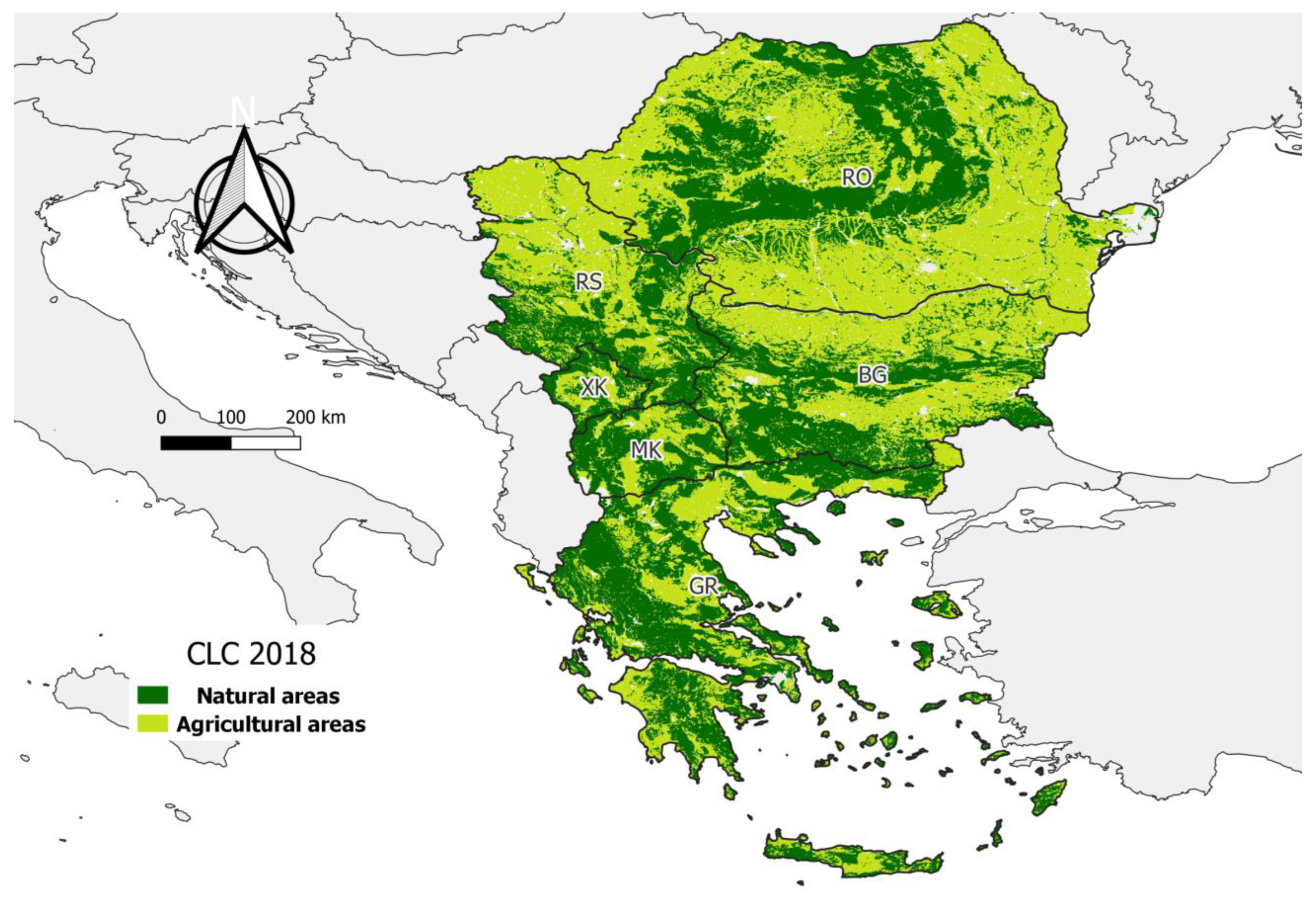
2.1. Study Area
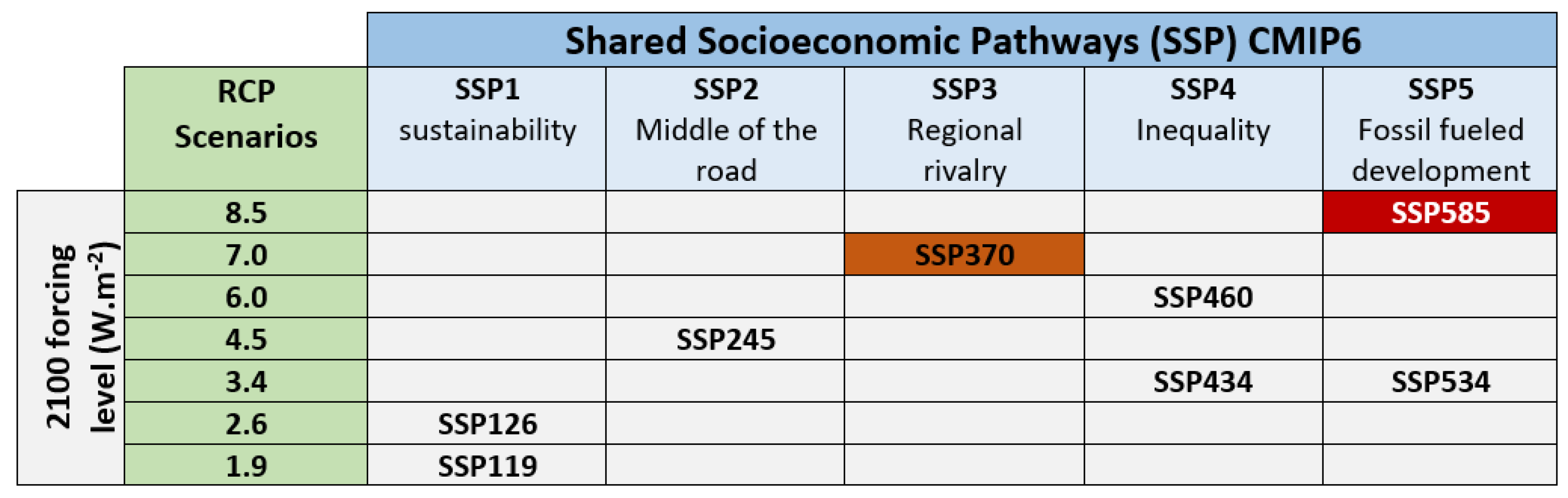
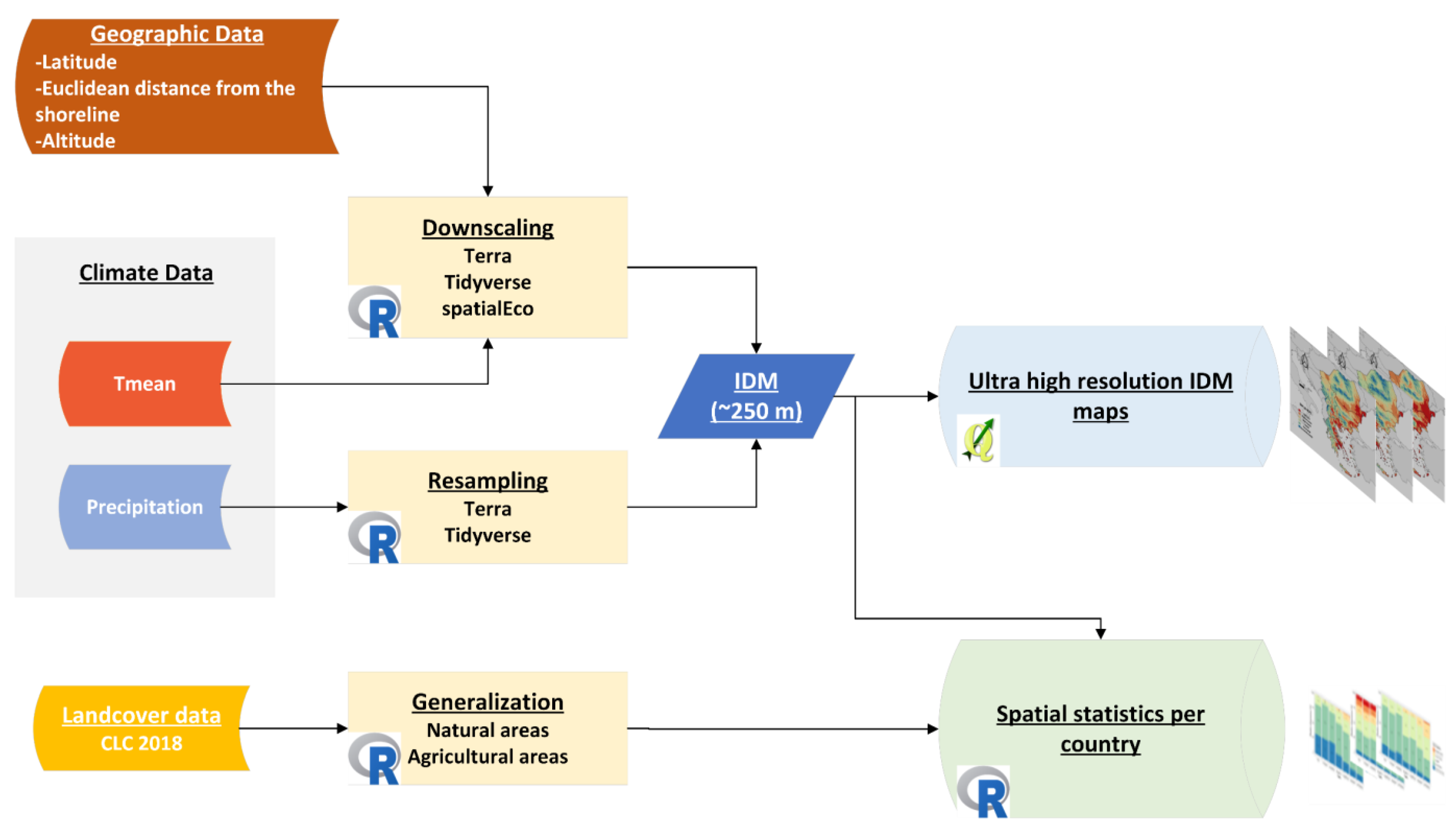
2.2. Data and Methods
Data and Analysis Process

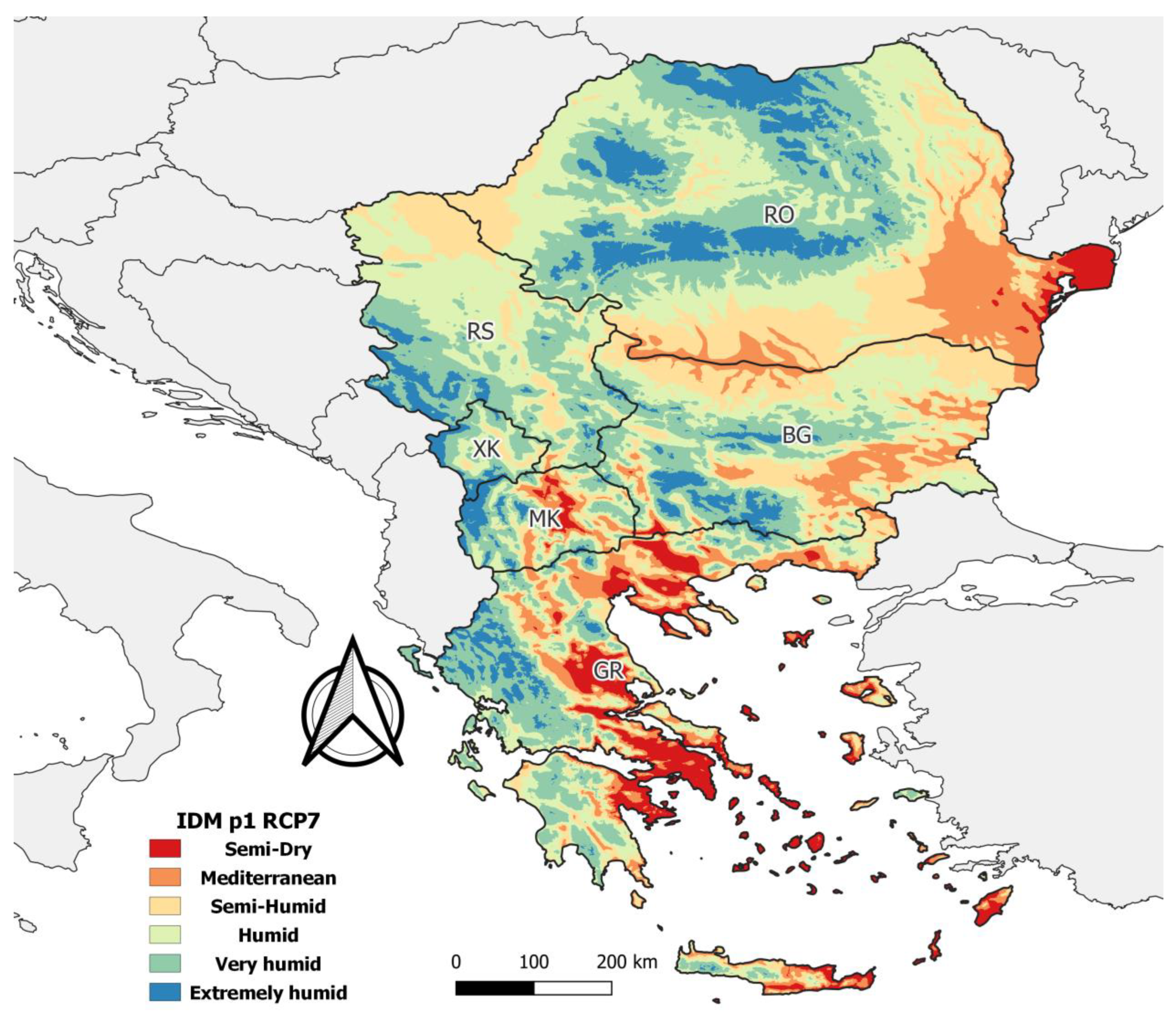
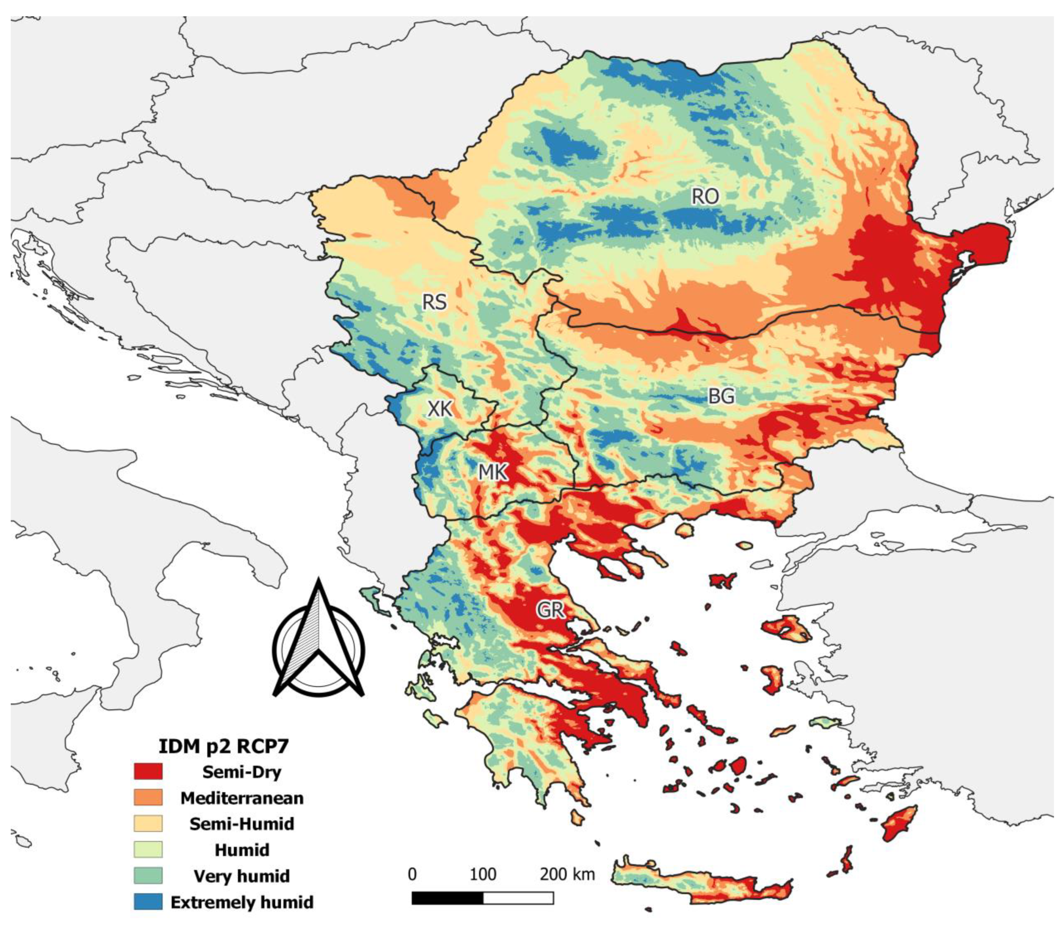
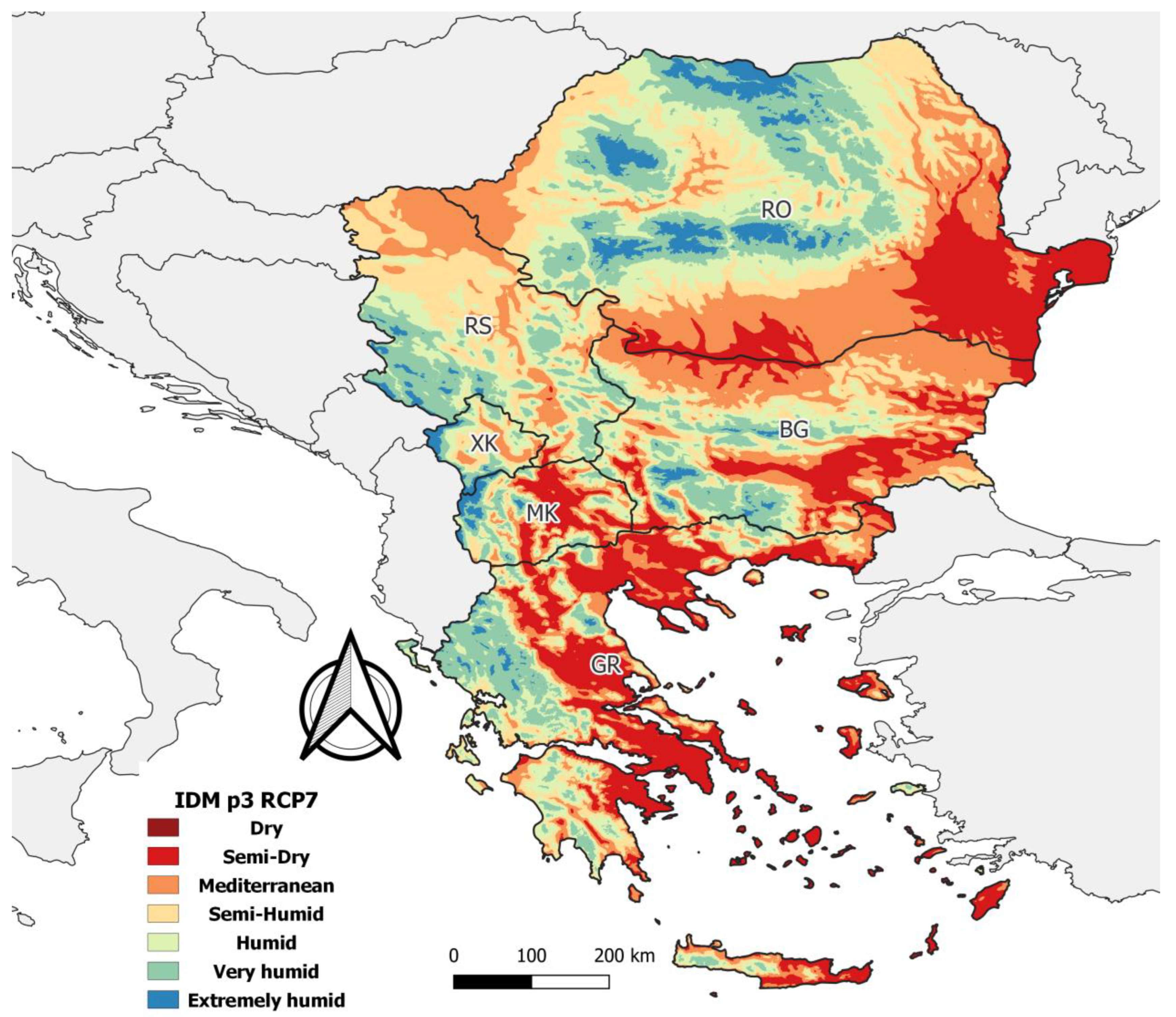
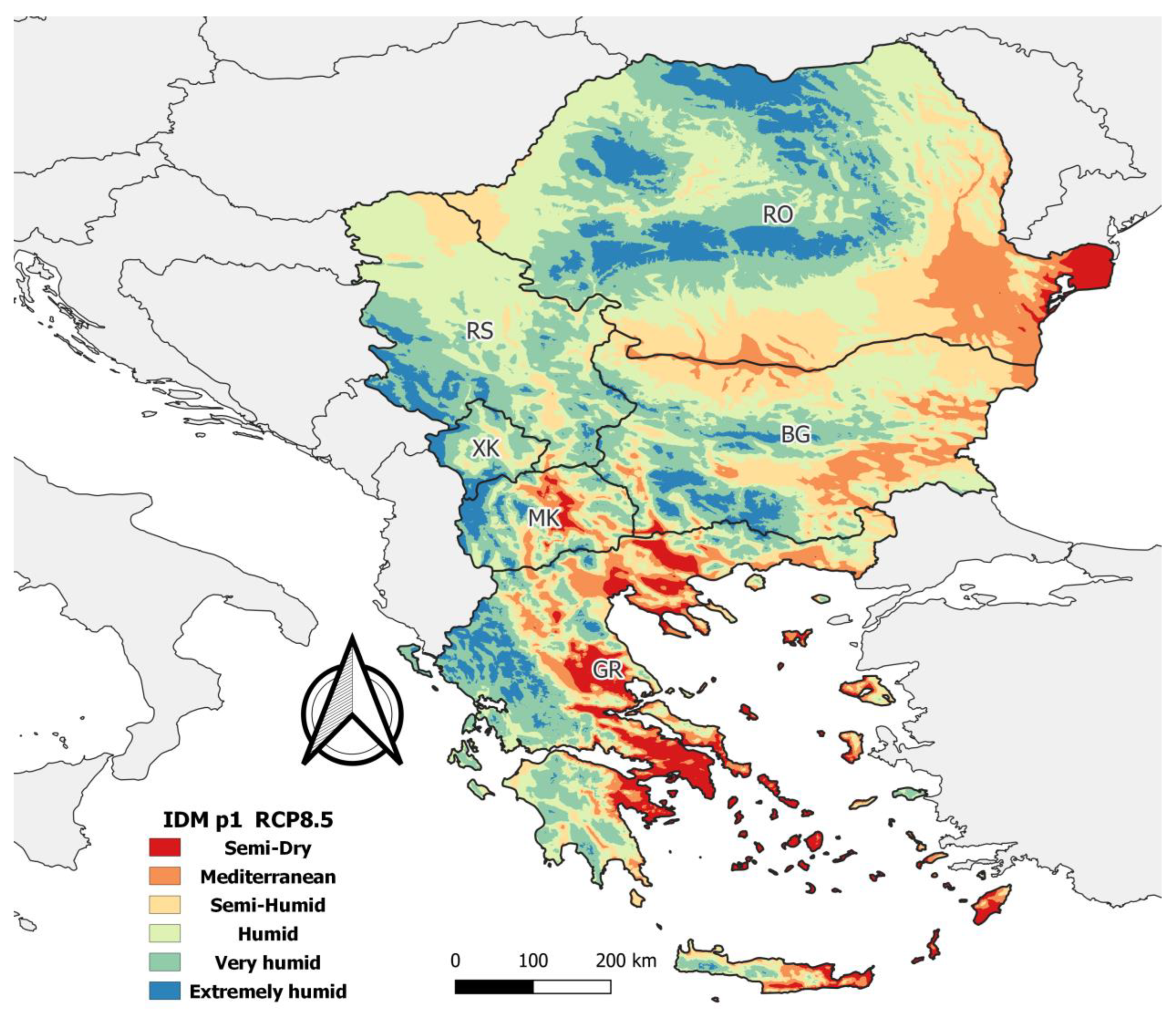
3. Results and Discussion
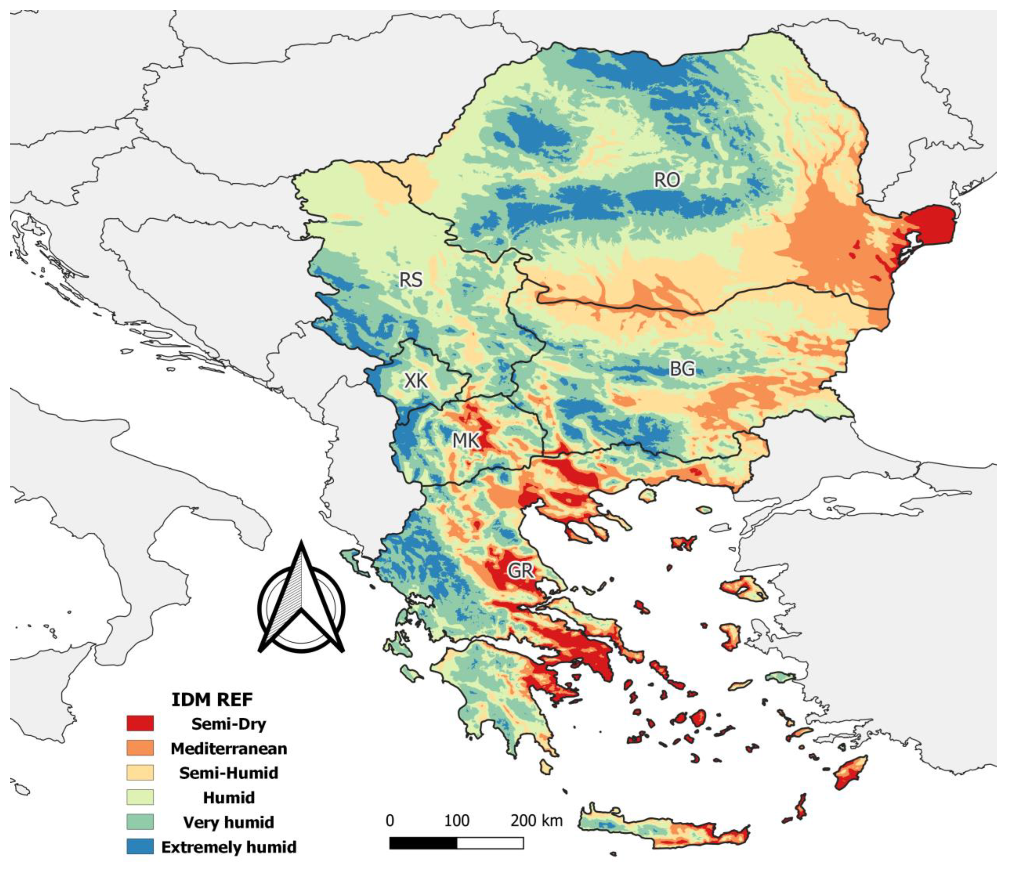
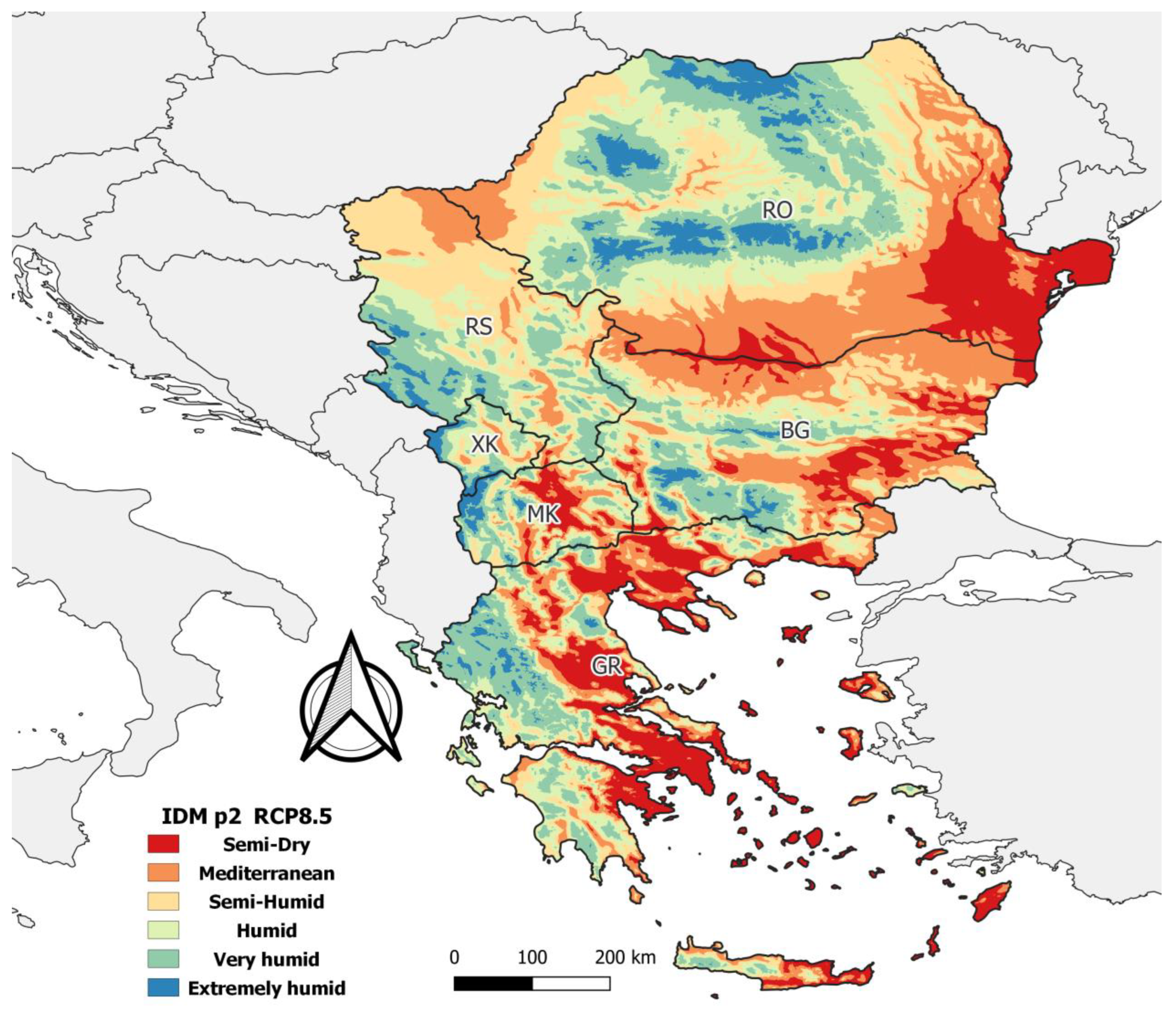
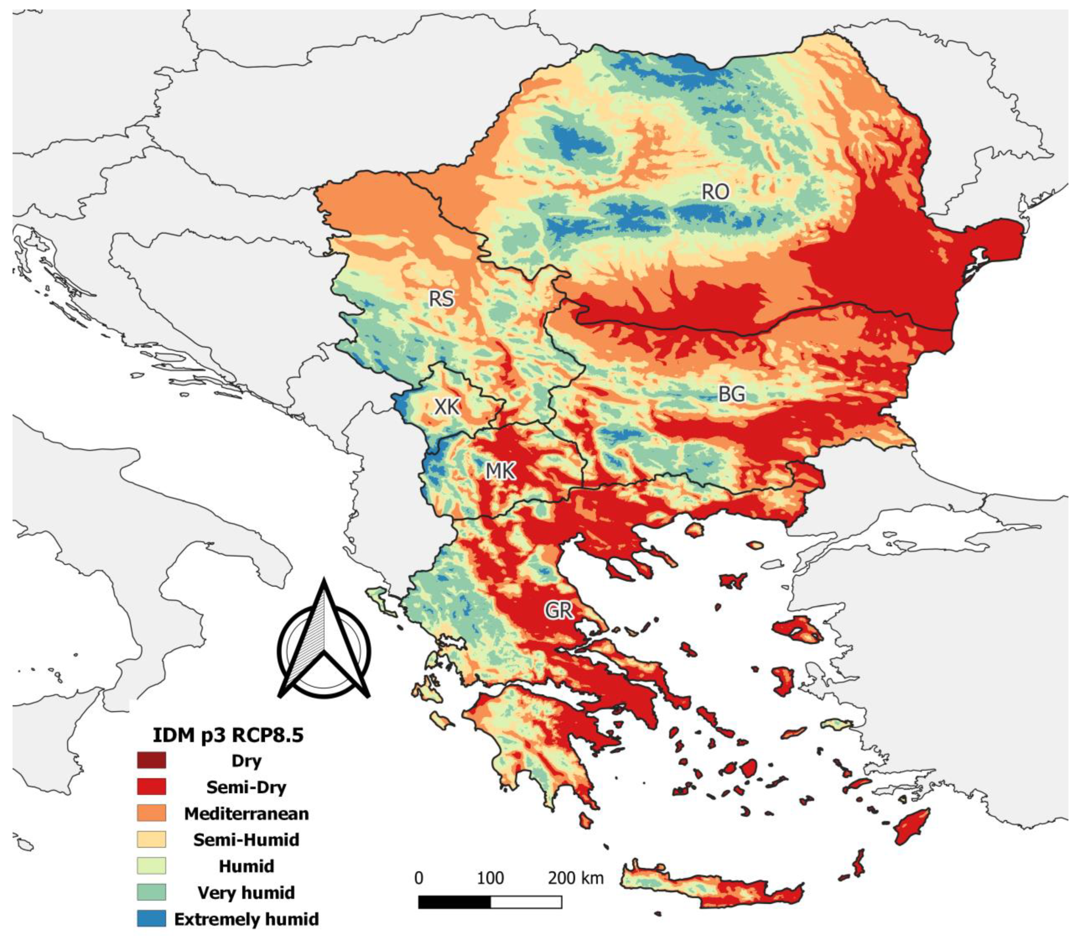
3.1. Spatial Patterns of the de Martonne Index
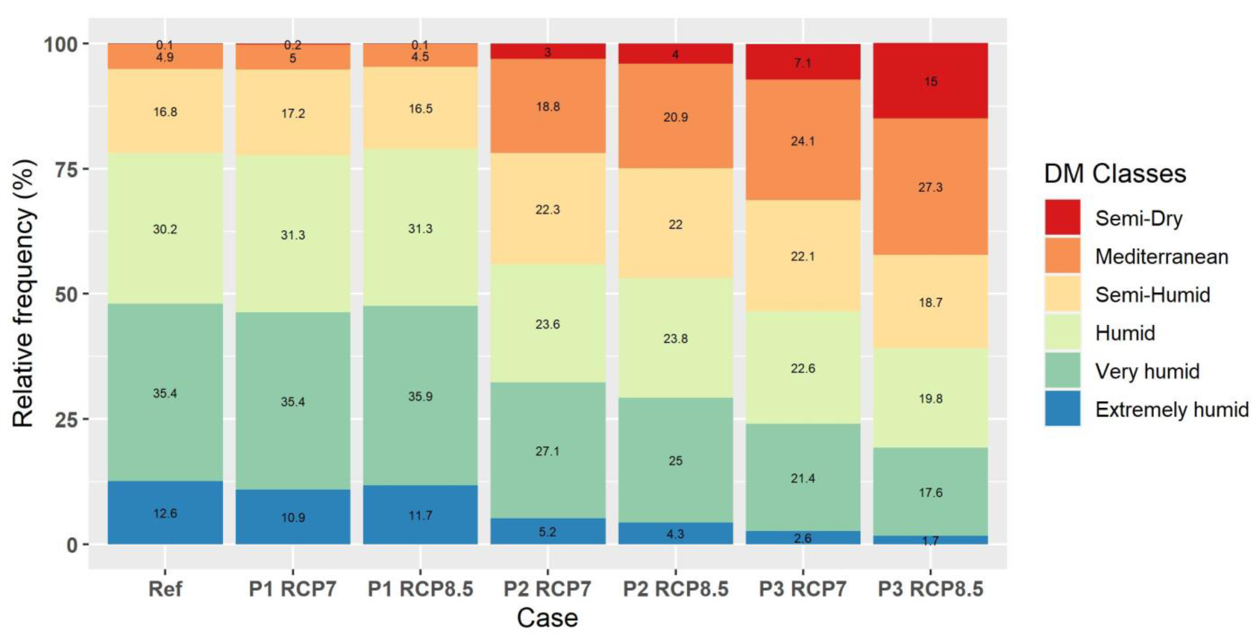
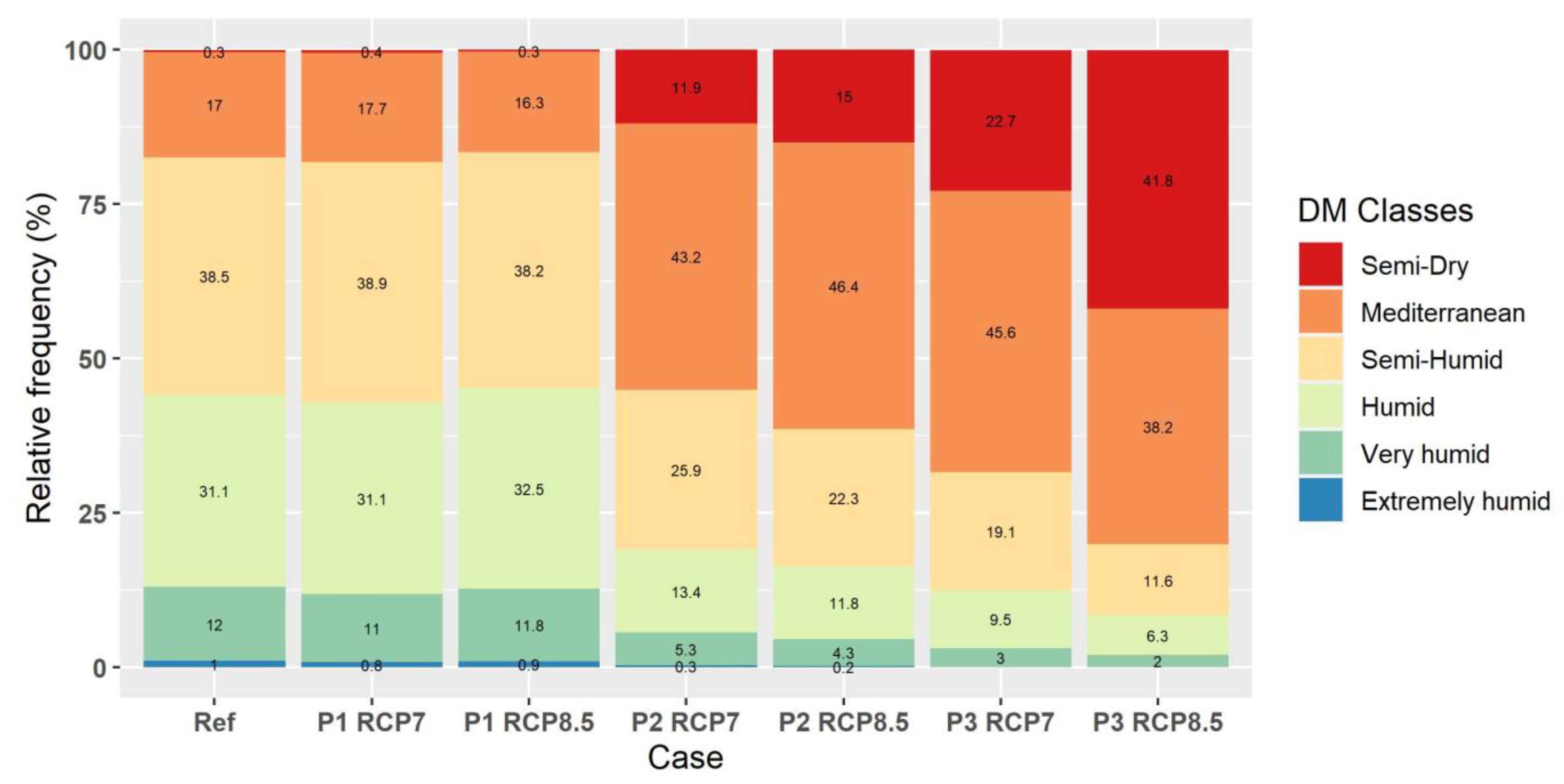
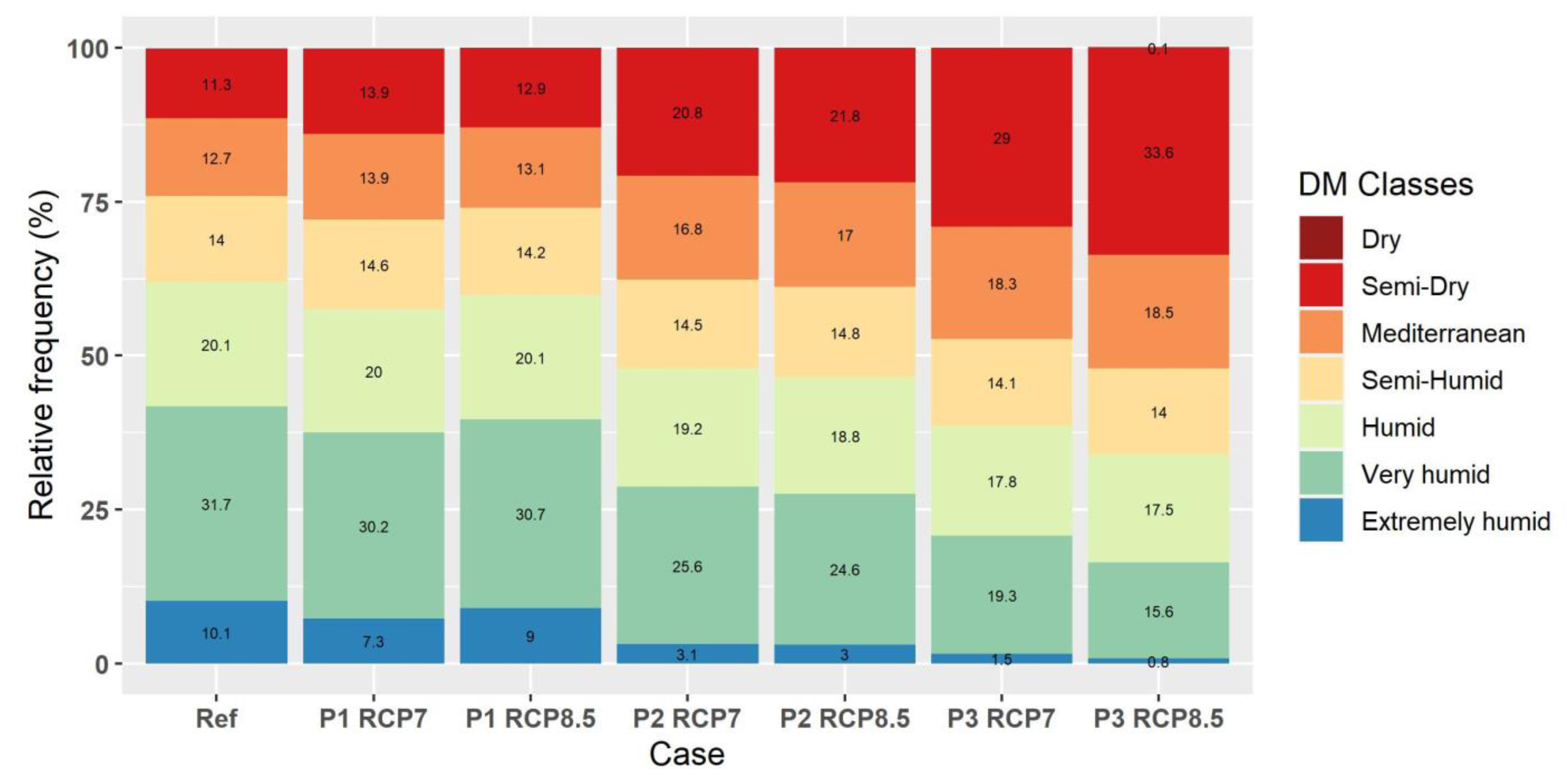
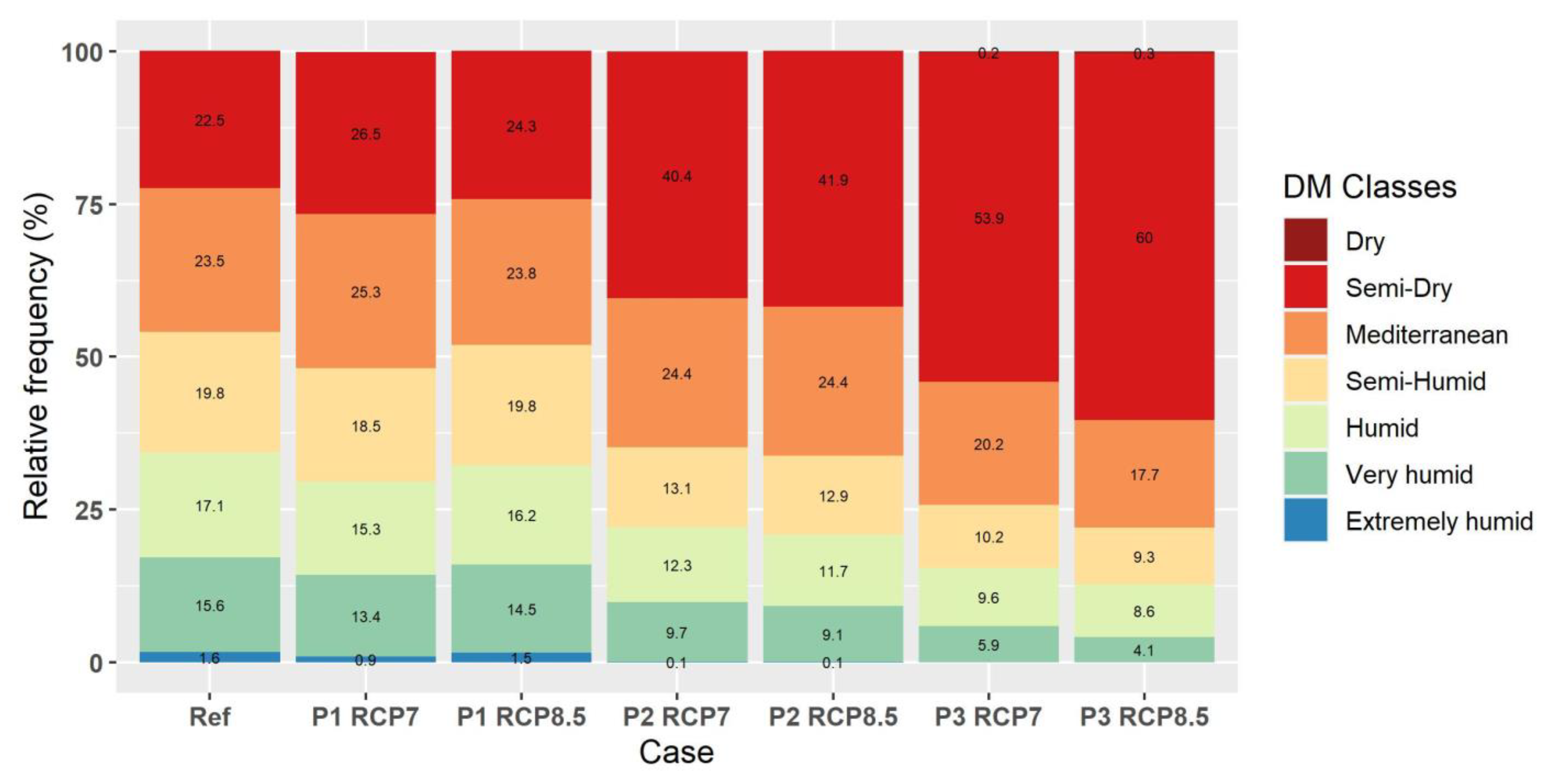
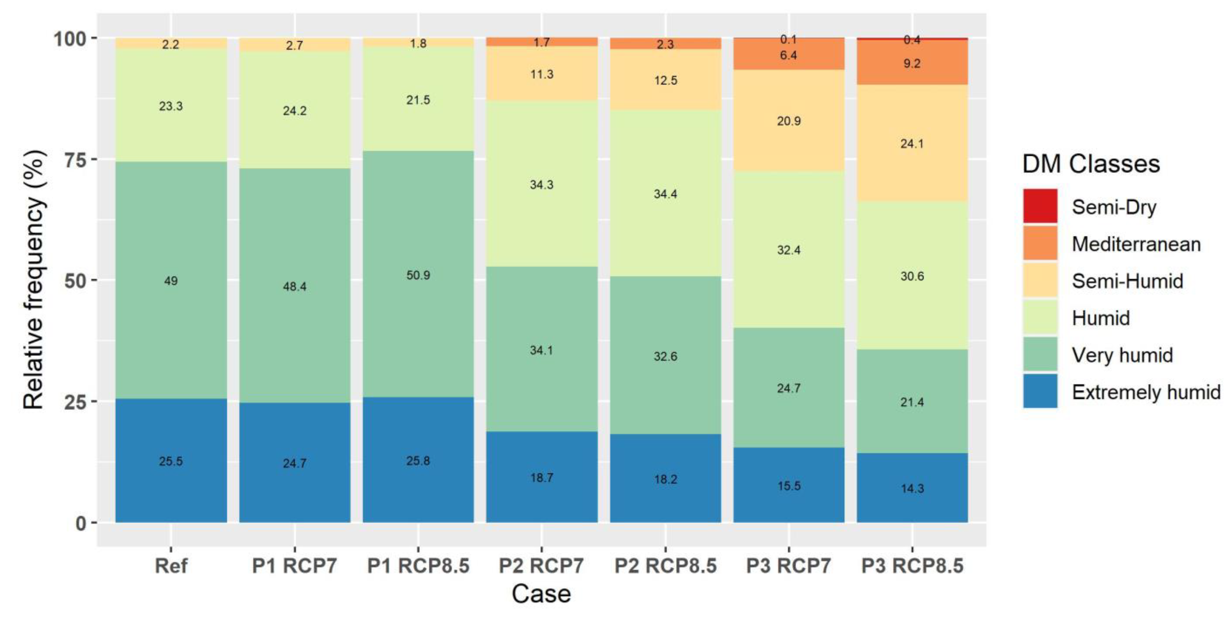
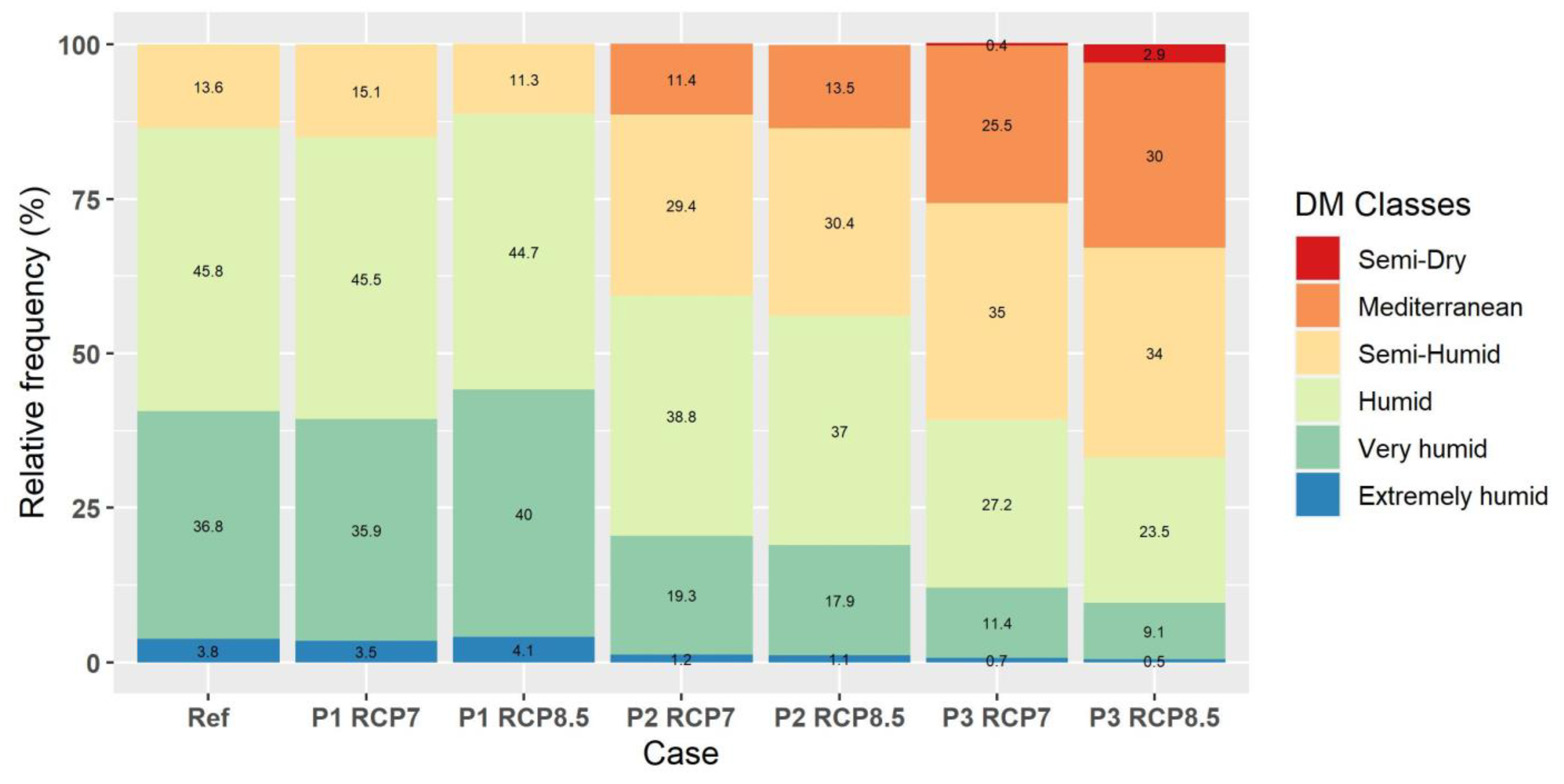
3.2. The de Martonne Classes’ Spatial Frequency over the PSEEU Countries
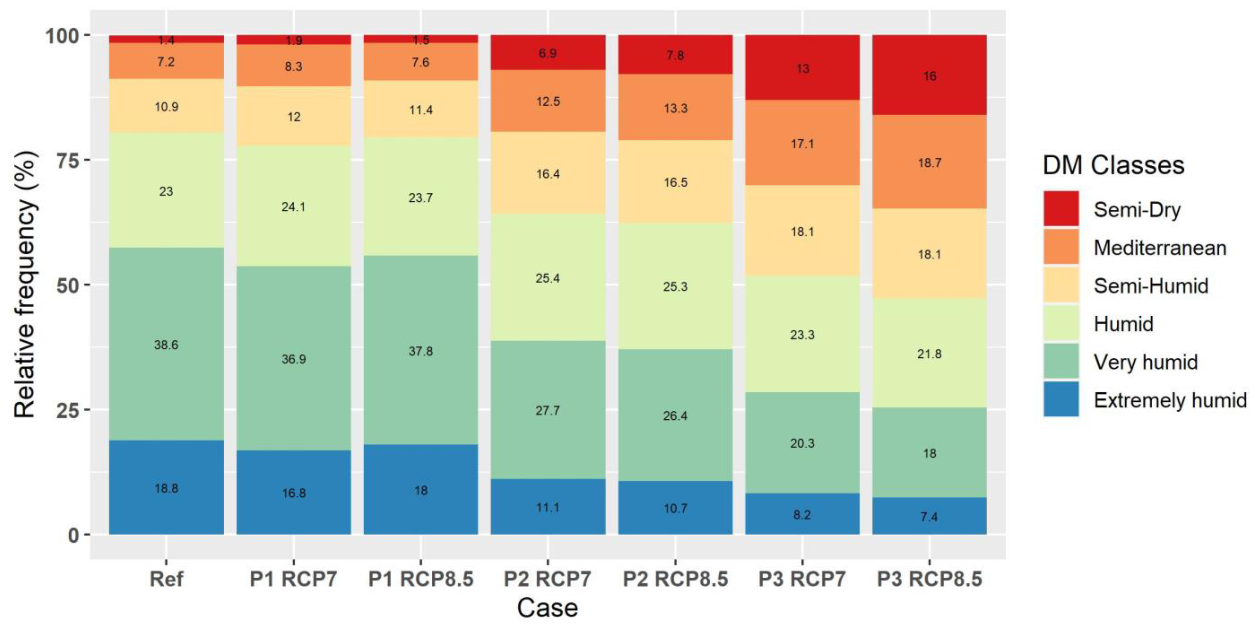
3.2.1. Bulgaria (BG)


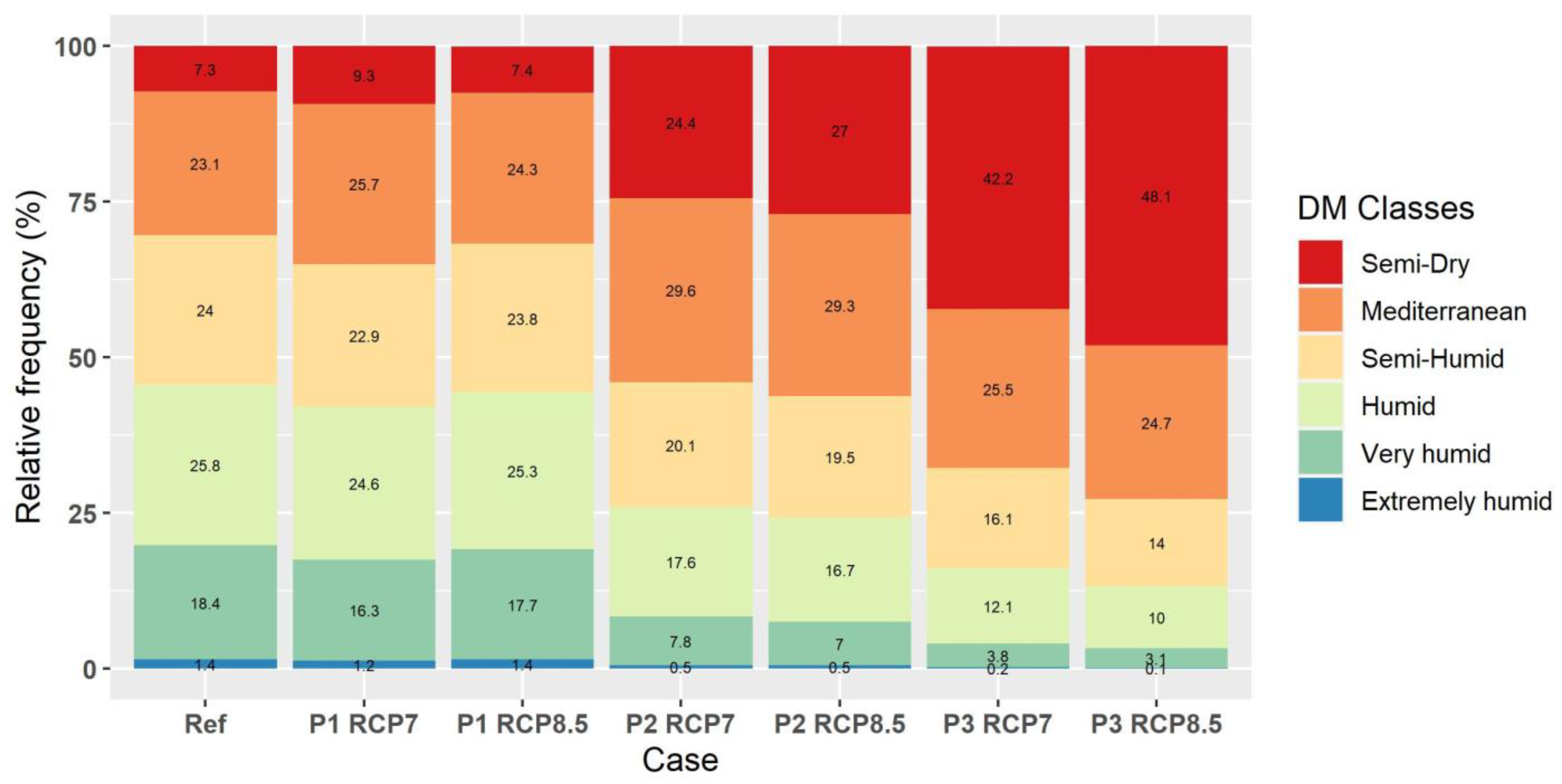
3.2.2. Greece (GR)


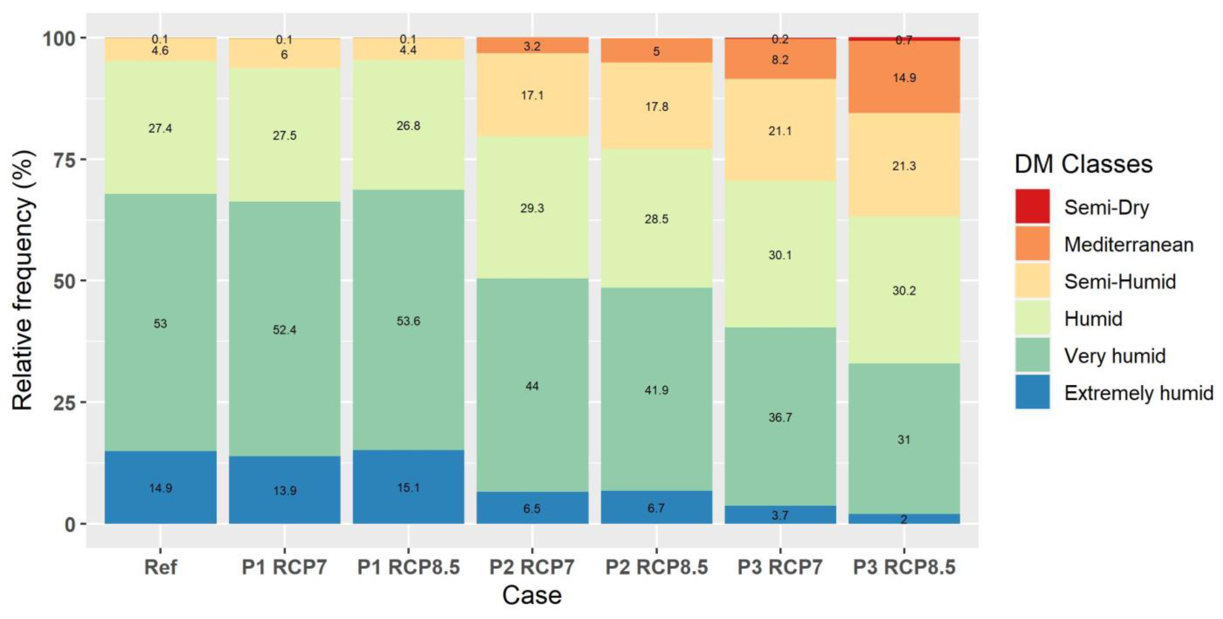
3.2.3. Kosovo (XK)


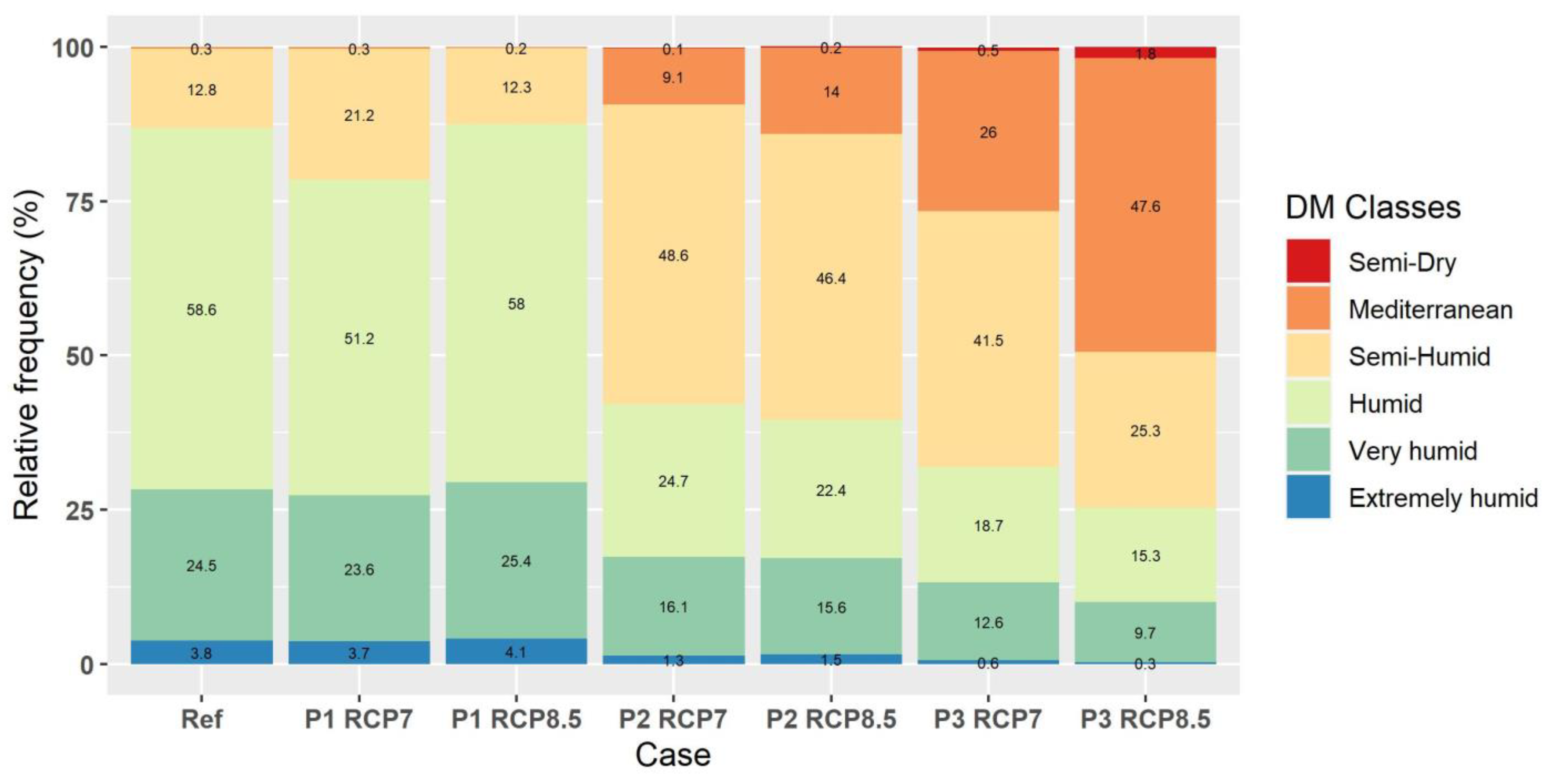
3.2.4. North Macedonia (MK)


3.2.5. Romania (RO)


3.2.6. Serbia (RS)


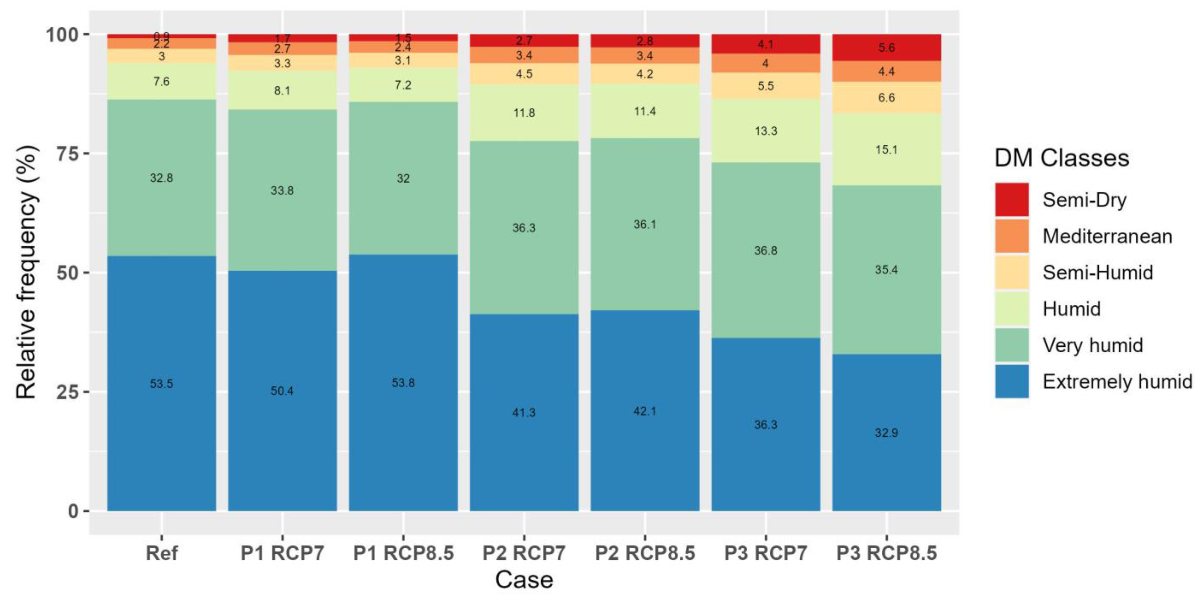
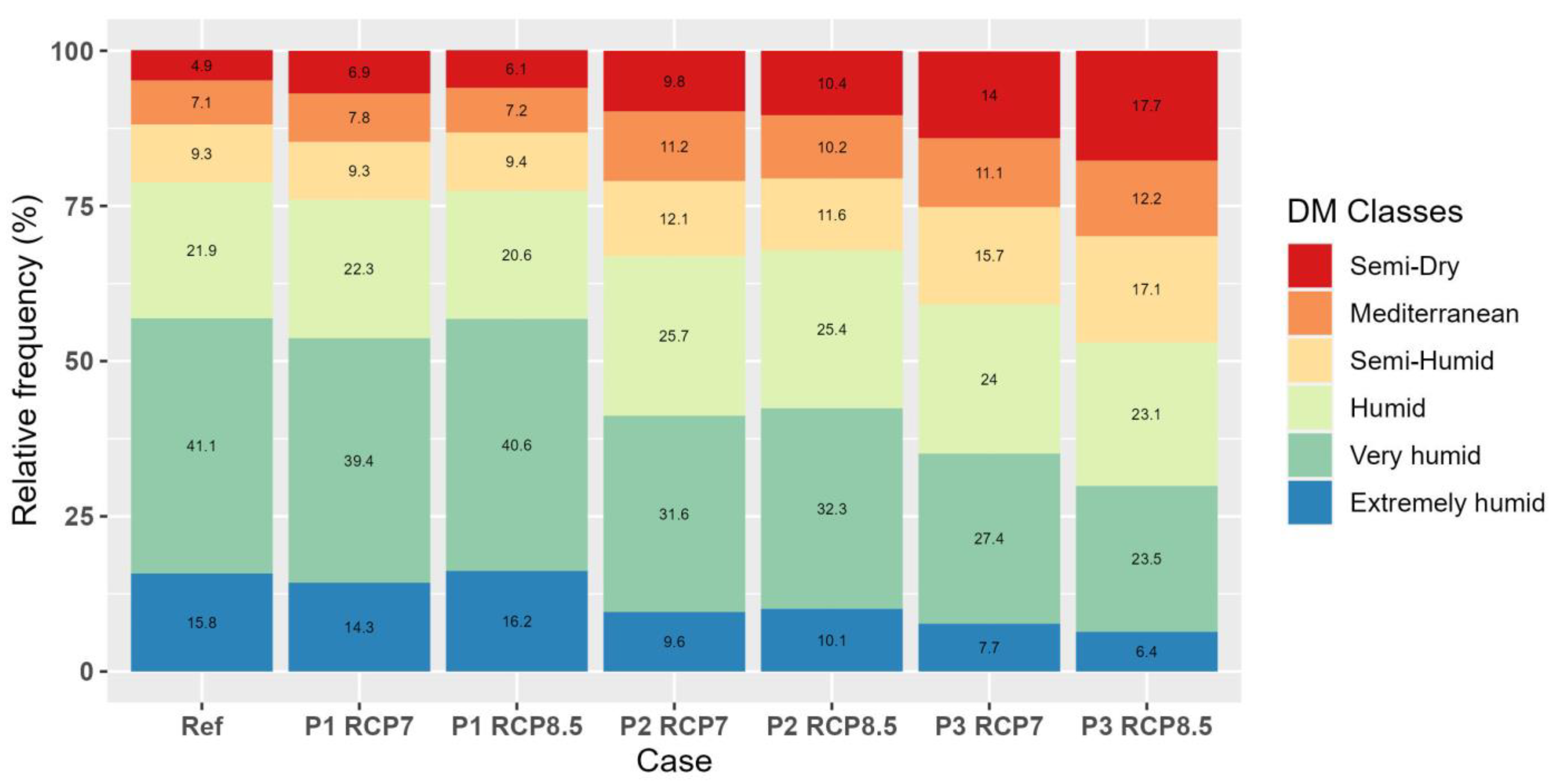
3.2.7. Total Area de Martonne Classes Spatial Frequency

4. Conclusions
Supplementary Materials
Author Contributions
Funding
Institutional Review Board Statement
Informed Consent Statement
Data Availability Statement
Acknowledgments
Conflicts of Interest
References
- Charalampopoulos, I.; Droulia, F. The Agro-Meteorological Caused Famines as an Evolutionary Factor in the Formation of Civilisation and History: Representative Cases in Europe. Climate 2021, 9, 5. [Google Scholar] [CrossRef]
- Bussotti, F.; Pollastrini, M. Traditional and Novel Indicators of Climate Change Impacts on European Forest Trees. Forests 2017, 8, 137. [Google Scholar] [CrossRef]
- Bandoc, G.; Prăvălie, R.; Patriche, C.; Dragomir, E.; Tomescu, M. Response of Phenological Events to Climate Warming in the Southern and South-Eastern Regions of Romania. Stoch. Environ. Res. Risk Assess. 2018, 32, 1113–1129. [Google Scholar] [CrossRef]
- Charalampopoulos, I.; Droulia, F.; Evans, J. The Bioclimatic Change of the Agricultural and Natural Areas of the Adriatic Coastal Countries. Sustainability 2023, 15, 4867. [Google Scholar] [CrossRef]
- Kokkoris, I.P.; Bekri, E.S.; Skuras, D.; Vlami, V.; Zogaris, S.; Maroulis, G.; Dimopoulos, D.; Dimopoulos, P. Integrating MAES Implementation into Protected Area Management under Climate Change: A Fine-Scale Application in Greece. Sci. Total Environ. 2019, 695, 133530. [Google Scholar] [CrossRef]
- Kokkoris, I.P.; Skuras, D.; Maniatis, Y.; Dimopoulos, P. Natura 2000 Public Awareness in EU: A Prerequisite for Successful Conservation Policy. Land Use Policy 2023, 125, 106482. [Google Scholar] [CrossRef]
- Droulia, F.; Charalampopoulos, I. Future Climate Change Impacts on European Viticulture: A Review on Recent Scientific Advances. Atmosphere 2021, 12, 495. [Google Scholar] [CrossRef]
- Nistor, M.-M. Climate Change Effect on Groundwater Resources in South East Europe during 21st Century. Quat. Int. 2019, 504, 171–180. [Google Scholar] [CrossRef]
- Perera, A.T.D.; Nik, V.M.; Chen, D.; Scartezzini, J.-L.; Hong, T. Quantifying the Impacts of Climate Change and Extreme Climate Events on Energy Systems. Nat. Energy 2020, 5, 150–159. [Google Scholar] [CrossRef]
- Alimonti, G.; Mariani, L.; Prodi, F.; Ricci, R.A. A Critical Assessment of Extreme Events Trends in Times of Global Warming. Eur. Phys. J. Plus 2022, 137, 112. [Google Scholar] [CrossRef]
- Charalampopoulos, I. Agrometeorological Conditions and Agroclimatic Trends for the Maize and Wheat Crops in the Balkan Region. Atmosphere 2021, 12, 671. [Google Scholar] [CrossRef]
- Giannakopoulos, C.; Kostopoulou, E.; Varotsos, K.V.; Tziotziou, K.; Plitharas, A. An Integrated Assessment of Climate Change Impacts for Greece in the near Future. Reg. Environ. Change 2011, 11, 829–843. [Google Scholar] [CrossRef]
- Cheval, S.; Dumitrescu, A.; Birsan, M.-V. Variability of the Aridity in the South-Eastern Europe over 1961–2050. CATENA 2017, 151, 74–86. [Google Scholar] [CrossRef]
- Pravalie, R.; Sîrodoev, I.; Peptenatu, D. Detecting Climate Change Effects on Forest Ecosystems in Southwestern Romania Using Landsat TM NDVI Data. J. Geogr. Sci. 2014, 24, 815–832. [Google Scholar] [CrossRef]
- Georgieva, V.; Kazandjiev, V.; Bozhanova, V.; Mihova, G.; Ivanova, D.; Todorovska, E.; Uhr, Z.; Ilchovska, M.; Sotirov, D.; Malasheva, P. Climatic Changes—A Challenge for the Bulgarian Farmers. Agriculture 2022, 12, 2090. [Google Scholar] [CrossRef]
- Tošić, I.; Unkašević, M.; Putniković, S. Extreme Daily Precipitation: The Case of Serbia in 2014. Theor. Appl. Clim. 2017, 128, 785–794. [Google Scholar] [CrossRef]
- Mavrakis, A.; Salvati, L. Analyzing the Behaviour of Selected Risk Indexes during the 2007 Greek Forest Fires. Int. J. Environ. Res. 2015, 9, 831–840. [Google Scholar]
- Ciceu, A.; Popa, I.; Leca, S.; Pitar, D.; Chivulescu, S.; Badea, O. Climate Change Effects on Tree Growth from Romanian Forest Monitoring Level II Plots. Sci. Total Environ. 2020, 698, 134129. [Google Scholar] [CrossRef]
- Češljar, G.; Jovanović, F.; Brašanac-Bosanac, L.; Đorđević, I.; Mitrović, S.; Eremija, S.; Ćirković-Mitrović, T.; Lučić, A. Impact of an Extremely Dry Period on Tree Defoliation and Tree Mortality in Serbia. Plants 2022, 11, 1286. [Google Scholar] [CrossRef]
- Sidor, C.G.; Camarero, J.J.; Popa, I.; Badea, O.; Apostol, E.N.; Vlad, R. Forest Vulnerability to Extreme Climatic Events in Romanian Scots Pine Forests. Sci. Total Environ. 2019, 678, 721–727. [Google Scholar] [CrossRef]
- Avram, S.; Ontel, I.; Gheorghe, C.; Rodino, S.; Roșca, S. Applying a Complex Integrated Method for Mapping and Assessment of the Degraded Ecosystem Hotspots from Romania. Int. J. Environ. Res. Public Health 2021, 18, 11416. [Google Scholar] [CrossRef]
- Kougioumoutzis, K.; Kokkoris, I.P.; Panitsa, M.; Trigas, P.; Strid, A.; Dimopoulos, P. Spatial Phylogenetics, Biogeographical Patterns and Conservation Implications of the Endemic Flora of Crete (Aegean, Greece) under Climate Change Scenarios. Biology 2020, 9, 199. [Google Scholar] [CrossRef] [PubMed]
- Jelena, T.-D.; Ivana, Z.; Dragana, S.; Mihailo, G. Climate Changes and Invasive Plant Species: Raising the Awareness of the Public towards Alien Invasive Plant Species in the City of Belgrade. FEB Fresenius Environ. Bull. 2016, 25, 4680. [Google Scholar]
- Iannella, M.; D’alessandro, P.; Biondi, M. Forecasting the Spread Associated with Climate Change in Eastern Europe of the Invasive Asiatic Flea Beetle, Luperomorpha Xanthodera (Coleoptera: Chrysomelidae). Eur. J. Entomol. 2020, 117, 130–138. [Google Scholar] [CrossRef]
- Gao, X.; Giorgi, F. Increased Aridity in the Mediterranean Region under Greenhouse Gas Forcing Estimated from High Resolution Simulations with a Regional Climate Model. Glob. Planet. Change 2008, 62, 195–209. [Google Scholar] [CrossRef]
- Nistor, M.-M.; Dezsi, Ş.; Cheval, S.; Baciu, M. Climate Change Effects on Groundwater Resources: A New Assessment Method through Climate Indices and Effective Precipitation in Beliş District, Western Carpathians. Meteorol. Appl. 2016, 23, 554–561. [Google Scholar] [CrossRef]
- Nistor, M.-M.; Ronchetti, F.; Corsini, A.; Cheval, S.; Dumitrescu, A.; Rai, P.K.; Petrea, D.; Dezsi, Ş. Crop Evapotranspiration Variation under Climate Change in South East Europe during 1991–2050. Carpathian J. Earth Environ. Sci. 2017, 12, 571–582. [Google Scholar]
- Iizumi, T.; Ramankutty, N. Changes in Yield Variability of Major Crops for 1981–2010 Explained by Climate Change. Environ. Res. Lett. 2016, 11, 034003. [Google Scholar] [CrossRef]
- Droulia, F.; Charalampopoulos, I. A Review on the Observed Climate Change in Europe and Its Impacts on Viticulture. Atmosphere 2022, 13, 837. [Google Scholar] [CrossRef]
- Cardell, M.F.; Amengual, A.; Romero, R. Future Effects of Climate Change on the Suitability of Wine Grape Production across Europe. Reg Environ. Change 2019, 19, 2299–2310. [Google Scholar] [CrossRef]
- Ontel, I.; Vladut, A. Impact of Drought on the Productivity of Agricultural Crops within the Oltenia Plain, Romania. Geogr. Pannonica 2015, 19, 9–19. [Google Scholar] [CrossRef]
- Charalampopoulos, I.; Droulia, F. Frost Conditions Due to Climate Change in South-Eastern Europe via a High-Spatiotemporal-Resolution Dataset. Atmosphere 2022, 13, 1407. [Google Scholar] [CrossRef]
- Charalampopoulos, I.; Polychroni, I.; Psomiadis, E.; Nastos, P. Spatiotemporal Estimation of the Olive and Vine Cultivations’ Growing Degree Days in the Balkans Region. Atmosphere 2021, 12, 148. [Google Scholar] [CrossRef]
- Baltas, E. Spatial distribution of climatic indices in northern Greece. Meteorol. Appl. 2007, 14, 69–78. [Google Scholar] [CrossRef]
- Savo, V.; Zuliani, E.; Salvati, L.; Perini, L.; Caneva, G. Long-Term Changes in Precipitation and Temperature Patterns and Their Possible Impacts on Vegetation (Tolfa-Cerite Area, Central Italy). Appl. Ecol. Environ. Res. 2012, 10, 243–266. [Google Scholar] [CrossRef]
- Lazoglou, G.; Anagnostopoulou, C.; Koundouras, S. Climate Change Projections for Greek Viticulture as Simulated by a Regional Climate Model. Theor. Appl. Climatol. 2018, 133, 551–567. [Google Scholar] [CrossRef]
- Charalampopoulos, I.; Tsiros, I.; Chronopoulou-Sereli, A.; Matzarakis, A. Analysis of Thermal Bioclimate in Various Urban Configurations in Athens, Greece. Urban Ecosyst. 2013, 16, 217–233. [Google Scholar] [CrossRef]
- Founda, D.; Katavoutas, G.; Pierros, F.; Mihalopoulos, N. Centennial Changes in Heat Waves Characteristics in Athens (Greece) from Multiple Definitions Based on Climatic and Bioclimatic Indices. Glob. Planet. Change 2022, 212, 103807. [Google Scholar] [CrossRef]
- Mihăilă, D.; Bistricean, P.-I.; Briciu, A.-E. Assessment of the Climate Potential for Tourism. Case Study: The North-East Development Region of Romania. Theor. Appl. Clim. 2019, 137, 601–622. [Google Scholar] [CrossRef]
- Bhuyan, U.; Zang, C.; Menzel, A. Different Responses of Multispecies Tree Ring Growth to Various Drought Indices across Europe. Dendrochronologia 2017, 44, 1–8. [Google Scholar] [CrossRef]
- Ugarković, D.; Paulić, V.; Šapić, I.; Poljak, I.; Ančić, M.; Tikvić, I.; Stankić, I. Climatic Relationship of Vegetation in Forest Stands in the Mediterranean Vegetation Belt of the Eastern Adriatic. Atmosphere 2022, 13, 1709. [Google Scholar] [CrossRef]
- Haidu, I.; Nistor, M.-M. Long-Term Effect of Climate Change on Groundwater Recharge in the Grand Est Region of France. Meteorol. Appl. 2020, 27, e1796. [Google Scholar] [CrossRef]
- Emadodin, I.; Corral, D.E.F.; Reinsch, T.; Kluß, C.; Taube, F. Climate Change Effects on Temperate Grassland and Its Implication for Forage Production: A Case Study from Northern Germany. Agriculture 2021, 11, 232. [Google Scholar] [CrossRef]
- Baltas, E.A. Climatic Conditions and Availability of Water Resources in Greece. Int. J. Water Resour. Dev. 2008, 24, 635–649. [Google Scholar] [CrossRef]
- Mavrakis, A.; Colantoni, A.; Salvati, L. Soil Degradation, Landscape and Climate Variations in a Mediterranean Agro-Forest System (Thriasio, Greece): Proposal for a Desertification Indicator Using Time Series Analysis. Int. J. Agric. Resour. Gov. Ecol. 2014, 10, 335–343. [Google Scholar] [CrossRef]
- Beloiu, M.; Poursanidis, D.; Tsakirakis, A.; Chrysoulakis, N.; Hoffmann, S.; Lymberakis, P.; Barnias, A.; Kienle, D.; Beierkuhnlein, C. No Treeline Shift despite Climate Change over the Last 70 Years. For. Ecosyst. 2022, 9, 100002. [Google Scholar] [CrossRef]
- Sidiropoulou, A.; Chouvardas, D.; Mantzanas, K.; Stefanidis, S.; Karatassiou, M. Impact of Transhumant Livestock Grazing Abandonment on Pseudo-Alpine Grasslands in Greece in the Context of Climatic Change. Land 2022, 11, 2126. [Google Scholar] [CrossRef]
- Mattas, C.; Anagnostopoulou, C.; Venetsanou, P.; Bilas, G.; Lazoglou, G. Evaluation of Extreme Dry and Wet Conditions Using Climate and Hydrological Indices in the Upper Part of the Gallikos River Basin. Proceedings 2018, 7, 3. [Google Scholar] [CrossRef]
- Lappas, I.; Zorapas, V.; Kaloumenos, K. Estimation and Surface Distribution of Climate Indices in the Water District of Central–Eastern Greece. In Proceedings of the 10th International Hydrogeological Congress of Greece, Thessaloniki, Greece, 8 October 2014. [Google Scholar]
- Bačević, N.; Vukoičić, D.; Nikolić, M.; Janc, N.; Milentijević, N.; Gavrilov, M. Aridity in Kosovo and Metohija, Serbia. Carpathian J. Earth Environ. Sci. 2017, 12, 563–570. [Google Scholar]
- Hrnjak, I.; Lukić, T.; Gavrilov, M.B.; Marković, S.B.; Unkašević, M.; Tošić, I. Aridity in Vojvodina, Serbia. Theor. Appl. Clim. 2014, 115, 323–332. [Google Scholar] [CrossRef]
- Gavrilov, M.B.; Radaković, M.G.; Sipos, G.; Mezősi, G.; Gavrilov, G.; Lukić, T.; Basarin, B.; Benyhe, B.; Fiala, K.; Kozák, P.; et al. Aridity in the Central and Southern Pannonian Basin. Atmosphere 2020, 11, 1269. [Google Scholar] [CrossRef]
- Gavrilov, M.B.; An, W.; Xu, C.; Radaković, M.G.; Hao, Q.; Yang, F.; Guo, Z.; Perić, Z.; Gavrilov, G.; Marković, S.B. Independent Aridity and Drought Pieces of Evidence Based on Meteorological Data and Tree Ring Data in Southeast Banat, Vojvodina, Serbia. Atmosphere 2019, 10, 586. [Google Scholar] [CrossRef]
- Radaković, M.G.; Tošić, I.; Bačević, N.; Mladjan, D.; Gavrilov, M.B.; Marković, S.B. The Analysis of Aridity in Central Serbia from 1949 to 2015. Theor. Appl Clim. 2018, 133, 887–898. [Google Scholar] [CrossRef]
- Moteva, M.; Kazandjiev, V.; Georgieva, V. Climate Change and the Hydrothermal and Evapotranspiration Conditions in the Planning Regions of Bulgaria. In Proceedings of the Fourteenth International Water Technology Conference—IWTC 2010, Cairo, Egypt, 21–23 March 2010. [Google Scholar]
- Vlăduţ, A.; Nikolova, N.; Licurici, M. Aridity Assessment within Southern Romania and Northern Bulgaria. Hrvat. Geogr. Glas. 2017, 79, 5–26. [Google Scholar] [CrossRef]
- Raev, I.; Alexandrov, V.; Tinchev, G. Assessment of Drought Related Climate Change Impacts on Forests in Bulgaria. Silva Balc. 2015, 16, 5–24. [Google Scholar]
- Strat, D. Trends in Climate and Bioclimate Profile of Sărăturile Beach Ridges Plain-Danube Delta. Ovidius Univ. Ann. 2010, 5, 17–30. [Google Scholar]
- Paltineanu, C.; Tanasescu, N.; Chitu, E.; Mihailescu, I.F. Relationships between the De Martonne Aridity Index and Water Requirements of Some Representative Crops: A Case Study from Romania. Int. Agrophys. 2007, 21, 81–93. [Google Scholar]
- Paltineanu, C.; Mihailescu, I.F.; Seceleanu, I.; Dragota, C.; Vasenciuc, F. Using Aridity Indices to Describe Some Climate and Soil Features in Eastern Europe: A Romanian Case Study. Theor. Appl. Climatol. 2007, 90, 263–274. [Google Scholar] [CrossRef]
- Croitoru, A.-E.; Piticar, A.; Imbroane, A.M.; Burada, D.C. Spatiotemporal Distribution of Aridity Indices Based on Temperature and Precipitation in the Extra-Carpathian Regions of Romania. Theor. Appl. Clim. 2013, 112, 597–607. [Google Scholar] [CrossRef]
- Vladut, A. Ecoclimatic Indexes within the Oltenia Plain. Forum Geogr. 2010, 9, 49–56. [Google Scholar]
- Prǎvǎlie, R. Climate Issues on Aridity Trends of Southern Oltenia in the Last Five Decades. Geogr. Tech. 2013, 1, 70–79. [Google Scholar]
- Vlăduţ, A.Ș.; Licurici, M. Aridity Conditions within the Region of Oltenia (Romania) from 1961 to 2015. Theor. Appl Clim. 2020, 140, 589–602. [Google Scholar] [CrossRef]
- Lungu, M.; Panaitescu, L.; Niţă, S. Aridity, Climatic Risk Phenomenon in Dobrudja. Present Environ. Sustain. Dev. 2011, 5, 179–190. [Google Scholar]
- Prăvălie, R.; Bandoc, G. Aridity Variability in the Last Five Decades in the Dobrogea Region, Romania. Arid Land Res. Manag. 2015, 29, 265–287. [Google Scholar] [CrossRef]
- Tiscovschi, A.; Manea, G.; Cocos, O.; Vijulie, I.; Cuculici, R. Characteristics of Aridity Conditions in Sout Dobroudja. Riscuri Si Catastr. Casa Cărţii De Sţiinţă Cluj-Napoca XII 2013, 12, 57–65. [Google Scholar]
- Vorovencii, I. Applying the Change Vector Analysis Technique to Assess the Desertification Risk in the South-West of Romania in the Period 1984–2011. Environ. Monit Assess 2017, 189, 524. [Google Scholar] [CrossRef]
- Pravalie, R.; Sîrodoev, I.; Peptenatu, D. Changes in the Forest Ecosystems in Areas Impacted by Aridization in South-Western Romania. J. Environ. Health Sci Eng. 2014, 12, 2. [Google Scholar] [CrossRef]
- Man, T.E.; Armas, A.; Beilicci, R.; Beilicci, E. Assessment Regarding the Evolution in Time (1980–2014) of Drought on the Basis of Several Computation Indexes: Study Case Timisoara. Nat. Resour. Sustain. Dev. 2018, 8, 1–8. [Google Scholar] [CrossRef]
- Mihai, G.; Alexandru, A.-M.; Nita, I.-A.; Birsan, M.-V. Climate Change in the Provenance Regions of Romania over the Last 70 Years: Implications for Forest Management. Forests 2022, 13, 1203. [Google Scholar] [CrossRef]
- Milovanović, B.; Schubert, S.; Radovanović, M.; Vakanjac, V.R.; Schneider, C. Projected Changes in Air Temperature, Precipitation and Aridity in Serbia in the 21st Century. Int. J. Climatol. 2022, 42, 1985–2003. [Google Scholar] [CrossRef]
- Butchart, N.; Anstey, J.A.; Kawatani, Y.; Osprey, S.M.; Richter, J.H.; Wu, T. QBO Changes in CMIP6 Climate Projections. Geophys. Res. Lett. 2020, 47, e2019GL086903. [Google Scholar] [CrossRef]
- Ceglar, A.; Toreti, A.; Zampieri, M.; Royo, C. Global Loss of Climatically Suitable Areas for Durum Wheat Growth in the Future. Environ. Res. Lett. 2021, 16, 104049. [Google Scholar] [CrossRef]
- Kolanowska, M.; Michalska, E.; Konowalik, K. The Impact of Global Warming on the Niches and Pollinator Availability of Sexually Deceptive Orchid with a Single Pollen Vector. Sci. Total Environ. 2021, 795, 148850. [Google Scholar] [CrossRef] [PubMed]
- Chemura, A.; Mudereri, B.T.; Yalew, A.W.; Gornott, C. Climate Change and Specialty Coffee Potential in Ethiopia. Sci. Rep. 2021, 11, 8097. [Google Scholar] [CrossRef] [PubMed]
- Wang, W.; Zhu, Q.; He, G.; Liu, X.; Peng, W.; Cai, Y. Impacts of Climate Change on Pine Wilt Disease Outbreaks and Associated Carbon Stock Losses. Agric. For. Meteorol. 2023, 334, 109426. [Google Scholar] [CrossRef]
- Reddy, N.M.; Saravanan, S. Extreme Precipitation Indices over India Using CMIP6: A Special Emphasis on the SSP585 Scenario. Environ. Sci. Pollut. Res. 2023, 30, 47119–47143. [Google Scholar] [CrossRef]
- Tollefson, J. What the War in Ukraine Means for Energy, Climate and Food. Nature 2022, 604, 232–233. [Google Scholar] [CrossRef]
- Dong, N.; You, L.; Cai, W.; Li, G.; Lin, H. Land Use Projections in China under Global Socioeconomic and Emission Scenarios: Utilizing a Scenario-Based Land-Use Change Assessment Framework. Glob. Environ. Change 2018, 50, 164–177. [Google Scholar] [CrossRef]
- Yang, W.; Ma, Y.; Jing, L.; Wang, S.; Sun, Z.; Tang, Y.; Li, H. Differential Impacts of Climatic and Land Use Changes on Habitat Suitability and Protected Area Adequacy across the Asian Elephant’s Range. Sustainability 2022, 14, 4933. [Google Scholar] [CrossRef]
- Donmez, C.; Schmidt, M.; Cilek, A.; Grosse, M.; Paul, C.; Hierold, W.; Helming, K. Climate Change Impacts on Long-Term Field Experiments in Germany. Agric. Syst. 2023, 205, 103578. [Google Scholar] [CrossRef]
- Jägermeyr, J.; Müller, C.; Ruane, A.C.; Elliott, J.; Balkovic, J.; Castillo, O.; Faye, B.; Foster, I.; Folberth, C.; Franke, J.A.; et al. Climate Impacts on Global Agriculture Emerge Earlier in New Generation of Climate and Crop Models. Nat. Food 2021, 2, 873–885. [Google Scholar] [CrossRef] [PubMed]
- Yao, L.; Zhou, H.; Yan, Y.; Su, Y. Projection of Suitability for the Typical Agro-Ecological Types in Central Asia under Four SSP-RCP Scenarios. Eur. J. Agron. 2022, 140, 126599. [Google Scholar] [CrossRef]
- Karger, D.N.; Wilson, A.M.; Mahony, C.; Zimmermann, N.E.; Jetz, W. Global Daily 1 Km Land Surface Precipitation Based on Cloud Cover-Informed Downscaling. Sci. Data 2021, 8, 307. [Google Scholar] [CrossRef]
- Karger, D.N.; Schmatz, D.R.; Dettling, G.; Zimmermann, N.E. High-Resolution Monthly Precipitation and Temperature Time Series from 2006 to 2100. Sci. Data 2020, 7, 248. [Google Scholar] [CrossRef]
- Guo, F.; Lenoir, J.; Bonebrake, T.C. Land-Use Change Interacts with Climate to Determine Elevational Species Redistribution. Nat. Commun. 2018, 9, 1315. [Google Scholar] [CrossRef]
- Margalef-Marrase, J.; Pérez-Navarro, M.Á.; Lloret, F. Relationship between Heatwave-Induced Forest Die-off and Climatic Suitability in Multiple Tree Species. Glob. Change Biol. 2020, 26, 3134–3146. [Google Scholar] [CrossRef] [PubMed]
- Christia, C.; Giordani, G.; Papastergiadou, E. Environmental Variability and Macrophyte Assemblages in Coastal Lagoon Types of Western Greece (Mediterranean Sea). Water 2018, 10, 151. [Google Scholar] [CrossRef]
- Lembrechts, J.J.; Lenoir, J.; Roth, N.; Hattab, T.; Milbau, A.; Haider, S.; Pellissier, L.; Pauchard, A.; Ratier Backes, A.; Dimarco, R.D.; et al. Comparing Temperature Data Sources for Use in Species Distribution Models: From in-Situ Logging to Remote Sensing. Glob. Ecol. Biogeogr. 2019, 28, 1578–1596. [Google Scholar] [CrossRef]
- Evans, J.S.; Murphy, M.A.; Ram, K. SpatialEco: Spatial Analysis and Modelling Utilities. 2022. Available online: https://CRAN.R-project.org/package=spatialEco (accessed on 12 December 2022).
- Wickham, H. The Tidyverse. Available online: https://www.tidyverse.org/ (accessed on 15 December 2022).
- Hijmans, R.J.; Bivand, R.; Forner, K.; Ooms, J.; Pebesma, E.; Sumner, M.D. Terra: Spatial Data Analysis. 2023. Available online: https://CRAN.R-project.org/package=terra (accessed on 7 July 2022).
- Rogelj, J.; Popp, A.; Calvin, K.V.; Luderer, G.; Emmerling, J.; Gernaat, D.; Fujimori, S.; Strefler, J.; Hasegawa, T.; Marangoni, G.; et al. Scenarios towards Limiting Global Mean Temperature Increase below 1.5 °C. Nat. Clim. Change 2018, 8, 325–332. [Google Scholar] [CrossRef]
- Meinshausen, M.; Nicholls, Z.R.J.; Lewis, J.; Gidden, M.J.; Vogel, E.; Freund, M.; Beyerle, U.; Gessner, C.; Nauels, A.; Bauer, N.; et al. The Shared Socio-Economic Pathway (SSP) Greenhouse Gas Concentrations and Their Extensions to 2500. Geosci. Model Dev. 2020, 13, 3571–3605. [Google Scholar] [CrossRef]
- O’Neill, B.C.; Tebaldi, C.; van Vuuren, D.P.; Eyring, V.; Friedlingstein, P.; Hurtt, G.; Knutti, R.; Kriegler, E.; Lamarque, J.-F.; Lowe, J.; et al. The Scenario Model Intercomparison Project (ScenarioMIP) for CMIP6. Geosci. Model Dev. 2016, 9, 3461–3482. [Google Scholar] [CrossRef]
- De Martonne, E. Regions of Interior-Basin Drainage. Geogr. Rev. 1927, 17, 397–414. [Google Scholar] [CrossRef]
- Passarella, G.; Bruno, D.; Lay-Ekuakille, A.; Maggi, S.; Masciale, R.; Zaccaria, D. Spatial and Temporal Classification of Coastal Regions Using Bioclimatic Indices in a Mediterranean Environment. Sci. Total Environ. 2020, 700, 134415. [Google Scholar] [CrossRef] [PubMed]
- European Environment Agency. CORINE Land Cover. Available online: http://www.eea.europa.eu/publications/COR0-landcover (accessed on 5 March 2017).
- QGIS Development Team. QGIS Geographic Information System; QGIS Association: Grüt, Switzerland, 2009. [Google Scholar]
- Tsiros, I.X.; Nastos, P.; Proutsos, N.D.; Tsaousidis, A. Variability of the Aridity Index and Related Drought Parameters in Greece Using Climatological Data over the Last Century (1900–1997). Atmos. Res. 2020, 240, 104914. [Google Scholar] [CrossRef]


| IDM Values | Types of Bioclimates | Description |
|---|---|---|
| IDM < 10 | Arid or dry | Needs continuous irrigation |
| 10 ≤ IDM < 20 | Semidry or semiarid | Needs irrigation |
| 20 ≤ IDM < 24 | Mediterranean | Needs supplementary irrigation |
| 24 ≤ IDM < 28 | Semi-humid | Needs supplementary irrigation |
| 28 ≤ IDM < 35 | Humid | Needs occasional irrigation |
| 35 ≤ IDM ≤ 55 | Very humid | Needs infrequent irrigation |
| IDM > 55 | Extremely humid | Water self-sufficient |
Disclaimer/Publisher’s Note: The statements, opinions and data contained in all publications are solely those of the individual author(s) and contributor(s) and not of MDPI and/or the editor(s). MDPI and/or the editor(s) disclaim responsibility for any injury to people or property resulting from any ideas, methods, instructions or products referred to in the content. |
© 2023 by the authors. Licensee MDPI, Basel, Switzerland. This article is an open access article distributed under the terms and conditions of the Creative Commons Attribution (CC BY) license (https://creativecommons.org/licenses/by/4.0/).
Share and Cite
Charalampopoulos, I.; Droulia, F.; Tsiros, I.X. Projecting Bioclimatic Change over the South-Eastern European Agricultural and Natural Areas via Ultrahigh-Resolution Analysis of the de Martonne Index. Atmosphere 2023, 14, 858. https://doi.org/10.3390/atmos14050858
Charalampopoulos I, Droulia F, Tsiros IX. Projecting Bioclimatic Change over the South-Eastern European Agricultural and Natural Areas via Ultrahigh-Resolution Analysis of the de Martonne Index. Atmosphere. 2023; 14(5):858. https://doi.org/10.3390/atmos14050858
Chicago/Turabian StyleCharalampopoulos, Ioannis, Fotoula Droulia, and Ioannis X. Tsiros. 2023. "Projecting Bioclimatic Change over the South-Eastern European Agricultural and Natural Areas via Ultrahigh-Resolution Analysis of the de Martonne Index" Atmosphere 14, no. 5: 858. https://doi.org/10.3390/atmos14050858
APA StyleCharalampopoulos, I., Droulia, F., & Tsiros, I. X. (2023). Projecting Bioclimatic Change over the South-Eastern European Agricultural and Natural Areas via Ultrahigh-Resolution Analysis of the de Martonne Index. Atmosphere, 14(5), 858. https://doi.org/10.3390/atmos14050858