Article

Development and Application of the SmartAQ High-Resolution Air Quality and Source Apportionment Forecasting System for European Urban Areas

by
Evangelia Siouti
1,2,
Ksakousti Skyllakou
2,
Ioannis Kioutsioukis
3,
David Patoulias
2,
George Fouskas
2 and
Spyros N. Pandis
1,2,*
1
Department of Chemical Engineering, University of Patras, 265 04 Patras, Greece
2
Institute of Chemical Engineering Sciences (ICE-HT), Foundation for Research and Technology Hellas (FORTH), 700 13 Patras, Greece
3
Department of Physics, University of Patras, 265 04 Patras, Greece
*
Author to whom correspondence should be addressed.
Atmosphere 2022, 13(10), 1693; https://doi.org/10.3390/atmos13101693
Submission received: 15 September 2022 / Revised: 8 October 2022 / Accepted: 11 October 2022 / Published: 16 October 2022
(This article belongs to the Special Issue Feature Papers in Air Quality)

Abstract

:
Air pollution forecasting systems are useful tools for the reduction in human health risks and the eventual improvement of atmospheric quality on regional or urban scales. The SmartAQ (Smart Air Quality) forecasting system combines state-of-the-art meteorological and chemical transport models to provide detailed air pollutant concentration predictions at a resolution of 1 × 1 km2 for the urban area of interest for the next few days. The Weather Research and Forecasting (WRF) mesoscale numerical weather prediction model is used to produce meteorological fields and the PMCAMx (Particulate Matter Comprehensive Air quality Model with extensions) chemical transport model for the simulation of air pollution. SmartAQ operates automatically in real time and provides, in its current configuration, a three-day forecast of the concentration of tens of gas-phase air pollutants (NOx, SO2, CO, O3, volatile organic compounds, etc.), the complete aerosol size/composition distribution, and the source contributions for all primary and secondary pollutants. The system simulates the regional air quality in Europe at medium spatial resolution and can focus, using high resolution, on any urban area of the continent. The city of Patras in Greece is used for the first SmartAQ application, taking advantage of the available Patras’ dense low-cost sensor network for PM2.5 (particles smaller than 2.5 μm) concentration measurements. Advantages of SmartAQ include (a) a high horizontal spatial resolution of 1 × 1 km2 for the simulated urban area; (b) advanced treatment of the organic aerosol volatility and chemistry; (c) use of an updated emission inventory that includes not only the traditional sources (industry, transport, agriculture, etc.), but also biomass burning from domestic heating and cooking; (d) forecasting of not only the pollutant concentrations, but also of the sources contributions for each one of them using the Particulate matter Source Apportionment Technology (PSAT) algorithm.

1. Introduction

Particulate matter (PM) is among the most important air pollutants and especially PM2.5 can penetrate deep into our lungs, causing serious cardiovascular and respiratory problems [1,2]. According to the World Health Organization [3], 4.2 million deaths every year are caused by ambient air pollution, while approximately 90% of the population worldwide live in areas where the suggested WHO air pollution limits are exceeded. Gas-phase pollutants such as nitrogen oxides (NOx) also have a negative effect on the human respiratory system [4], while excessive levels of ozone (O3) can cause breathing problems such as asthma and lung diseases [3]. Air quality forecasting systems are becoming increasingly useful as they can predict future air quality and thus help reduce the risk of people being exposed to high air pollutant levels if appropriate mitigation measures are taken.
Both statistical methods and chemical transport models (CTMs) have been used for air quality forecasting [5,6,7]. Statistical models are based on algorithms that use past air quality and meteorological data [8,9]. These approaches require low computational time, but do not consider explicit pollutant emissions and atmospheric processes. CTMs, on the other hand, forecast air quality simulating in detail both the meteorology and the chemical and physical processes of the atmosphere during the forecast period. Air quality forecasting using CTMs requires limited or no historical data and can provide valuable information about the sources of pollutants (local or long-range transport) and the production of secondary pollutants [10].
There are several air quality forecasting systems in operation that predict atmospheric pollution on global, regional, and urban scales. The Copernicus Atmosphere Monitoring Service (CAMS) is a multi-model system that provides forecasts on a global and European scale [11]. A median value of the predictions of nine individual chemical transport models (CHIMERE, DEHM, EMEP, EURAC-IM, GEM-AQ, LOTOS-EUROS, MATCH, MOCAGE and SILAM) is used for forecasting air quality on a moderate horizontal spatial resolution of 10 × 10 km2 [12]. A moderate spatial resolution of 10 × 10 km2 is also used in the PREV’ AIR (Prevision de la qualité de l’ air) system that forecasts air quality over France [13]. The Korean Air Quality Prediction System (KAQPS) was developed to predict concentrations of major pollutants in South Korea [14] using data assimilation of satellite and ground-based observations, with a horizontal spatial resolution of 15 × 15 km2. The Marco-Polo prediction system is applied in eastern China using nine different CTMs (IFS, CHIMERE, SILAM, EMEP, LOTOS-EUROS, WRF-CMAQ, WARMS-CMAQ, WRF-Chem-SMS and WRF-Chem-MPIM). The IFS model runs on a global scale, with a horizontal spatial resolution of 40 km, while the other eight models are regional with spatial resolutions down to 6 km [15]. The MM5-CAMx forecast system is used in Greece with a high spatial resolution of 2 × 2 km2 for the urban areas of Athens and Thessaloniki. The corresponding emission inventory used does not include cooking emissions and the model has a simplified treatment of secondary organic aerosols [16].
Simulation of secondary organic aerosol (SOA) formation is a weakness of most currently used air quality forecasting systems. Most emission inventories and CTMs are not taking in account the semi-volatile nature of primary organic aerosol (POA) emissions and neglect its subsequent chemical processing [17,18]. Donahue et al. [17] proposed a framework for the simulation of POA based on their volatility distribution, called Volatility Basis Set (VBS). Low-volatility organic compounds (LVOCs, volatility bins 10−3, 10−2, 10−1 μg m−3) are always in the particle phase, while those that are defined as intermediate-volatility (IVOCs, volatility bins 103, 104, 105, and 106 μg m−3) are always found in the gas phase. Additionally, there are organic compounds that exist in both particulate and gas phase and are defined as semi-volatile (SVOCs, volatility bins 100, 101, 102 μg m−3) [19]. VOCs, IVOCs, SVOCs can be oxidized in the gas phase and produce SOA. For the CAMS system, the SOA formation is not simulated in the MOCAGE and LOTOS-EUROS models, while CHIMERE, EMEP, EURAD-IM, MATCH and DEHM consider POA as non-volatile [12,20,21,22,23]. SILAM is the only model of the CAMS system that treats POA as semi-volatile. Additionally, the PREV’ AIR, KAQPS and MM5-CAMx forecasting systems assume that POA emissions are non-volatile [16,24,25]. For the Marco-Polo system, the CHIMERE, EMEP, LOTOS-EUROS, WRF-CMAQ and WRF-Chem-SMS models used threat POA as non-volatile, while SILAM considers the aging of POA emissions depending on their volatility [15].
Weaknesses of current air quality forecasting systems are related to their horizontal spatial resolution when used for urban areas, their treatment of primary and secondary OA and the corresponding emission inventories. The moderate spatial resolution often used may limit the model ability to reproduce variations in urban areas. The treatment of residential biomass burning and cooking emissions, which are becoming major local sources in several cities [26,27,28,29,30] is also often a weakness. These two sources have received relatively little attention in urban emission inventories and corresponding model applications because of the challenges in estimating the total emissions, but also their spatial and temporal variability.
This work describes the development of an air quality forecasting system that combines state-of-the-art chemical transport and meteorological modeling to produce detailed air quality predictions at 1 × 1 km2 resolution for the urban area of interest for the next three days. The system combines high-resolution predictions of meteorology by the WRF model, real-time predictions of future emissions, and the chemical transport model PMCAMx for the simulation of air quality. The source apportionment algorithm PSAT is used together with PMCAMx to determine the contributions of different emission sources to the predicted concentration levels of the urban area. The real-time forecasts are evaluated continuously against available measurements from a network of low-cost sensors and regulatory monitors.

2. SmartAQ System

The SmartAQ air quality forecasting system developed in this work consists of six main models to predict weather, anthropogenic, biogenic, and marine emissions, pollutant concentrations and pollutant sources. SmartAQ operates daily providing forecasts of the concentration of several of all major gas-phase (NOx, SO2, CO, O3, volatile organic compounds, etc.) and particle-phase air pollutants (PM1, PM2.5, and PM10) as well as the chemical composition and aerosol-size distribution. The system uses three nested grids with increasing spatial resolution and can focus on any European urban area. The city of Patras in Greece is used for the first application described in this work.
The SmartAQ system uses the WRF model for the calculation of all the necessary meteorological fields (cloud, precipitation, temperature, etc.) for the prediction of air quality [31]. The MEGAN (Model of Emissions of Gases and Aerosols from Nature) is used to estimate gas and aerosol emissions of natural and terrestrial ecosystems combining the WRF meteorological data and land use information [32,33]. The marine emissions (sea-salt and organics) are estimated based on the O’Dowd [34] and Monahan [35] algorithms using the wind speed above the sea surface predicted by WRF. Anthropogenic emissions are based on the TNO emission inventory [36] and are selected depending on the simulation day. The PMCAMx chemical transport model is used for simulating air pollution in the selected area [37] and the PSAT algorithm [38,39,40,41,42,43] for estimating the contribution of each source to pollutant concentrations. Additional details are provided in the next paragraphs.
A simplified flow diagram of the SmartAQ system is shown in Figure 1. WRF runs firstly and produces hourly gridded meteorological data that then are translated into a compatible format for PMCAMx. Ozone concentrations from NASA Ozone Watch and land use distributions from WRF are used to generate UV albedo, haze turbidity and ozone column data that PMCAMx needs as inputs. Meteorological data are also used as input for MEGAN to produce biogenic emissions. Wind speed values from WRF outputs, and chlorophyll-a concentrations are used as input data to the marine emission model for preparing hourly gridded sea-salt and organic emissions. Anthropogenic emissions are estimated for each day taking into account if it is a weekday or weekend and also the corresponding month. Once all the necessary inputs are generated, PMCAMx simulates all the atmospheric processes, while at the same time PSAT estimates the contribution of each source to each pollutant in each grid cell without interfering with the PMCAMx simulation. As a result, SmartAQ predicts the hourly gridded concentrations of gases and particles for each day and their sources.
SMARTAQ is relatively computationally efficient as simulations for a 3-day period require approximately 10 h in an Intel Xeon Gold processor.

2.1. Meteorology

The meteorological fields for the next three days are predicted using WRF v4.1.5 [31]. Four two-way nests are used for the dynamic downscaling of the meteorological fields from the coarse domain covering Europe (d01) at 36 km horizontal resolution down to the 1 km resolution domain over the Patras area (d04) (Figure 2). The intermediate domains d02 and d03, with horizontal resolution 12 km and 3 km, respectively, are placed around the d04. WRF is used with 28 vertical sigma levels extending up to a height of approximately 20 km (50 hPa).
The initial and lateral boundary conditions of WRF are obtained from the Global Forecast System (GFS) forecast, which starts every day at 12 UTC. The GFS has 28 km horizontal resolution, uses 57 vertical layers, and provides output at 1 h temporal resolution. WRF forecasts are produced for the next 84 h (3.5 days), starting at 12:00 UTC of day 0 and ending at 00 UTC of day 4 with the first 12 h serving as spin-up time. WRF output is recorded every 60 min.
The United States Geological Survey (USGS) geographical datasets for topography and land-use are used as input to WRF. The finest domain (d04) uses the Global 30 Arc-Second Elevation Model (GTOPO30) dataset for land topography with 30 arc seconds resolution while coarser resolution datasets of 10 min, 5 min, 2 min are used for the domains d01, d02, d03, respectively. Twenty-four land-use categories are used at the same resolution as the topography data (i.e.,10 min, 5 min, 2 min, 30 arc seconds).
The selection of the physical schemes in WRF is based on recent comparative studies using WRF in the study area [44,45]. Longwave and shortwave radiation is simulated by the Rapid Radiative Transfer Model for GCM (RRTMG) scheme [46], suitable for high-resolution WRF simulations. Cumulus convection is parameterized with the Kain–Fritsch scheme in the 36 and 12 km domains [47]. The cumulus scheme is not activated for the 3 km and 1 km domains, because at higher resolution, the model can theoretically resolve convection explicitly. Microphysics is parameterized with the Rapid Radiative Transfer Model for GCM (RRTMG) scheme, a fast scheme that includes ice, snow and graupel processes [48]. For turbulence, we selected the non-local Yonsei University (YSU) scheme [49] while MM5 similarity was selected for the surface layer scheme [50]. Finally, the Noah Land Surface Model (Noah LSM) model is used for the land surface [51].

2.2. Air Quality Model

The chemical transport model PMCAMx v2.0, the research version of CAMx [52], is used to simulate air pollution in all domains. The model simulates vertical and horizontal diffusion, vertical and horizontal advection, gas, aqueous and aerosol phase chemistry, wet and dry deposition, and emissions of primary pollutants by solving the continuity equation for each pollutant [52]. For gas-phase chemistry, the modified SAPRC mechanism is used with 217 reactions and up to 114 species [52,53]. For aqueous-phase chemistry, the Variable Size Resolution Model developed by Fahey and Pandis [54] is used. The bulk equilibrium approach is used in this application for the simulation of gas-aerosol partitioning of inorganic and secondary organic components [55]. For wet deposition, a scavenging model for gas and aerosol components is used [56], while for dry deposition, the models of Wesely [57] and Slinn and Slinn [58] are employed.
The Volatility Basis Set (VBS) scheme [17] is used for the organic aerosol. Both primary and secondary OA are treated as semi-volatile and chemically reactive. According to their volatilities, SVOCs and IVOCs can react with OH radicals, reduce their volatilities by an order of magnitude and increase their mass by 7.5% [59]. The approaches of Gaydos et al. [60] and Koo et al. [61] are used for simulating the inorganic aerosol, while the secondary organic aerosol formation and growth follow Koo et al. [62].
The PMCAMx model uses the same horizontal grids and resolutions as the WRF model. The outer European domain covers a region of 5400 × 5832 km2, while the three nested domains, which cover parts of Greece, regions of 276 × 276, 114 × 114 and 36 × 36 km2, respectively (Figure 2a,b). The urban domain of Patras is in the center of the simulated inner 36 × 36 km2 region. PMCAMx uses 14 vertical layers with a height of up to 6 km for all the modeling domains. The surface layer extends approximately up to 50 m. Emissions are prepared for the European domain and the urban domain of Patras, while for the other two nested domains interpolation is used.

2.3. Biogenic Emissions

MEGAN v3 [32,33] is used for predicting hourly gridded biogenic emissions for the European and urban domains. Emissions of 201 individual gas-phase compounds are estimated and then are lumped into 27 simulated species including isoprene, monoterpenes, and sesquiterpenes (Table S1). The driving variables for producing biogenic emissions are environmental conditions (temperature, soil moisture, light, wind speed, and humidity) predicted by WRF and land cover data such as Leaf Area Index (spatial and temporal distribution of canopy growth) and Plant Functional Type distributions [32]. The emission at standard conditions is scaled in MEGAN by an activity factor that accounts for change in environmental conditions [33].

2.4. Marine Aerosol Emissions

Marine aerosol emissions include size-resolved sea-salt and marine organics. For sea-salt and organic material with a diameter of up to 1 μm the O’Dowd distribution is assumed [34], while the Monahan distribution is used for supermicrometer sea-salt particles [35]. The O’Dowd approach needs as input data the wind speed at 22 m above the sea surface that is obtained hourly from the WRF model. The marine chlorophyll-a concentration is used for estimating the organic mass percentage of sea-spray aerosols. The monthly concentrations of chlorophyll-a are obtained from MODIS (Moderate-Resolution Imaging Spectroradiometer). The Monahan distribution needs the wind speed at 10 m above the sea surface that is obtained from WRF every hour. As a result, the required hourly gridded NaCl emissions of 8 size-resolved bins up to 10 μm and organic aerosol emissions of 4 size-resolved bins up to 1 μm are estimated for the European (d01) and urban domain (d04).

2.5. Anthropogenic Emissions

2.5.1. Emissions for the European Domain

The anthropogenic emissions for the European domain are based on the updated EUCAARI Pan-European inventory developed by the Netherlands Organization of Applied Scientific Research (TNO) [36]. This update is based on the European Environment Agency 2020 Report, based on which, PM emissions have decreased approximately by 20% in Europe from 2007 until 2017, while ammonia emissions only by 5%. Sulfate and nitrogen oxides emissions have decreased by 80 and 40%, respectively. The anthropogenic emissions are divided into 11 source categories provided by the Selected Nomenclature for Air Pollution (SNAP). This includes industrial, domestic, road, non-road, agricultural and shipping emissions. The point sources are placed in the corresponding grid cell. The anthropogenic emissions change based on the day of the week and month.

2.5.2. Emissions for the Urban Domain of Patras

The anthropogenic area emissions for the urban domain of Patras are downscaled from the European inventory of 36 × 36 km2 spatial resolution to 1 × 1 km2 resolution using a series of surrogates.
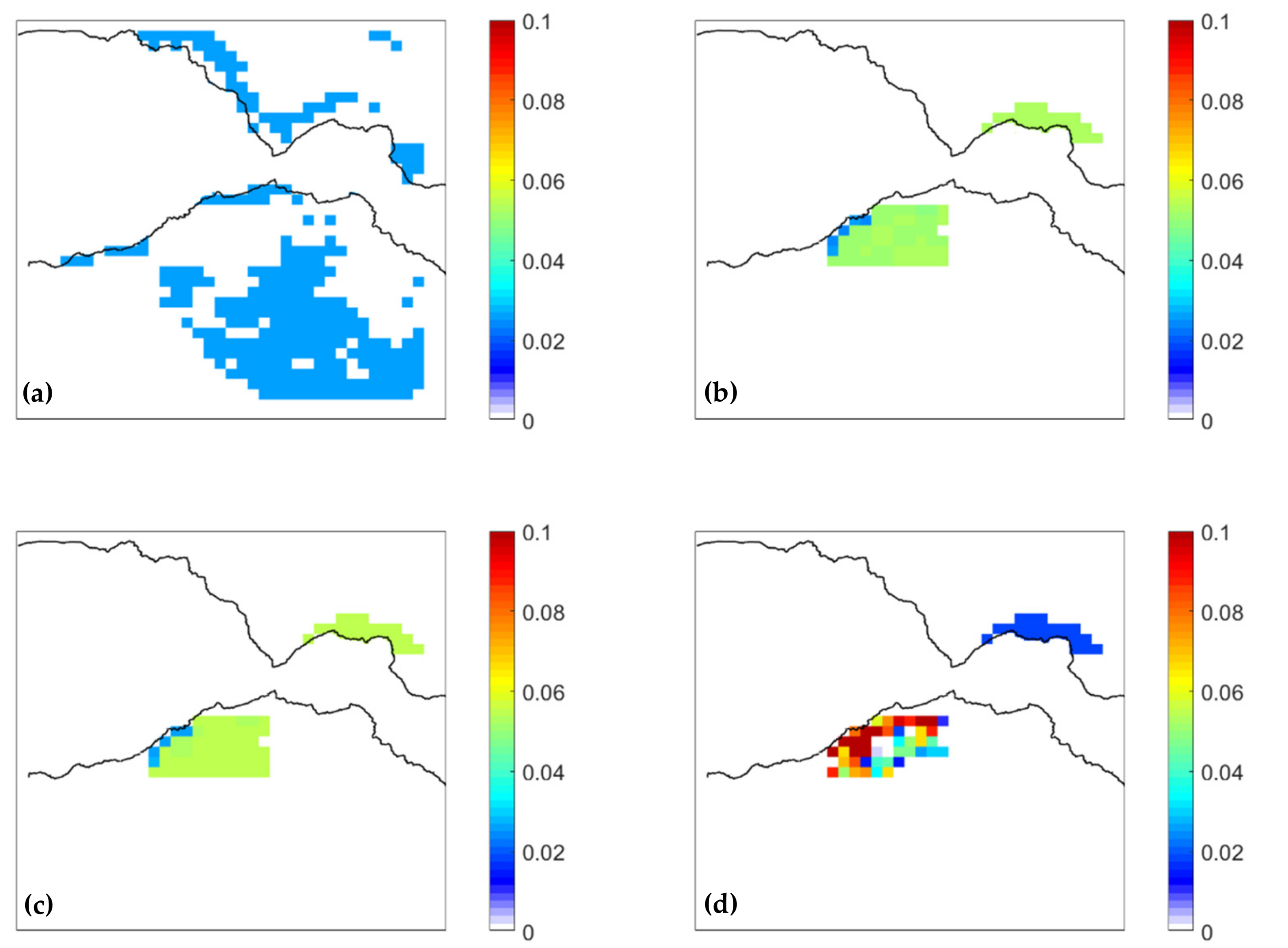
The anthropogenic emissions are updated according to the 2019 national inventory for Greece [63]. PM emissions (primary OA, elemental carbon, dust) have decreased by 43% in Greece from 2007 until 2017, while NH3 emissions have decreased by 16%. SOx and sulfate emissions have decreased by 90% and NOx emissions by 44%. The reported reductions have been applied to all anthropogenic categories of the TNO emission inventory, for both area and point emissions. The total PM10 emissions in the inner domain per source during December 2021 are shown in Figure 3.
The agricultural emissions (SNAP 10) are evenly distributed to the agricultural and range land 1 × 1 km2 resolution grid cells. The corresponding emissions and their spatial distribution are shown in Figure 3a.
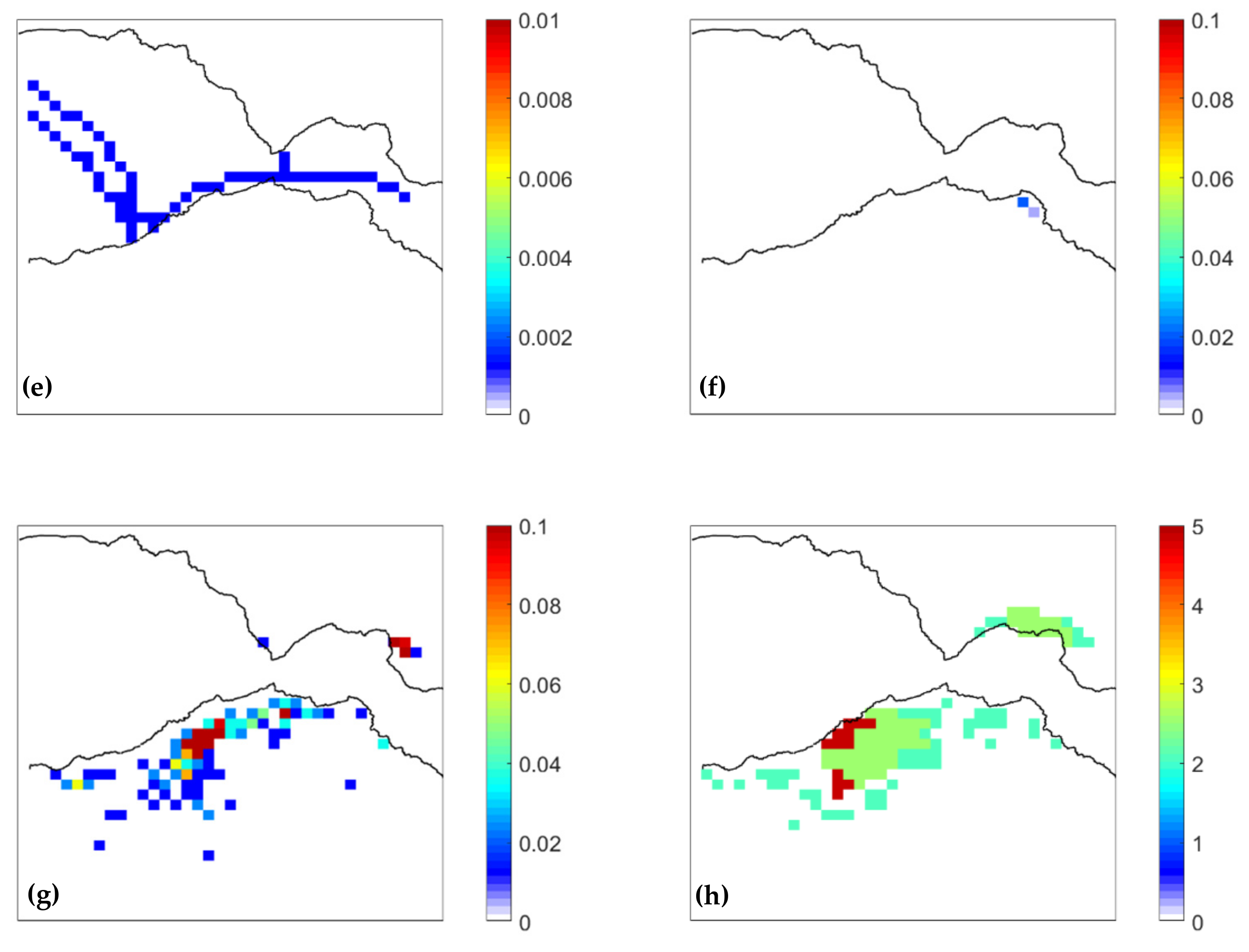
The emissions from domestic processes (SNAP 2) and non-road transportation (SNAP 8) are equally distributed to the urban grid cells (Figure 3b,c).
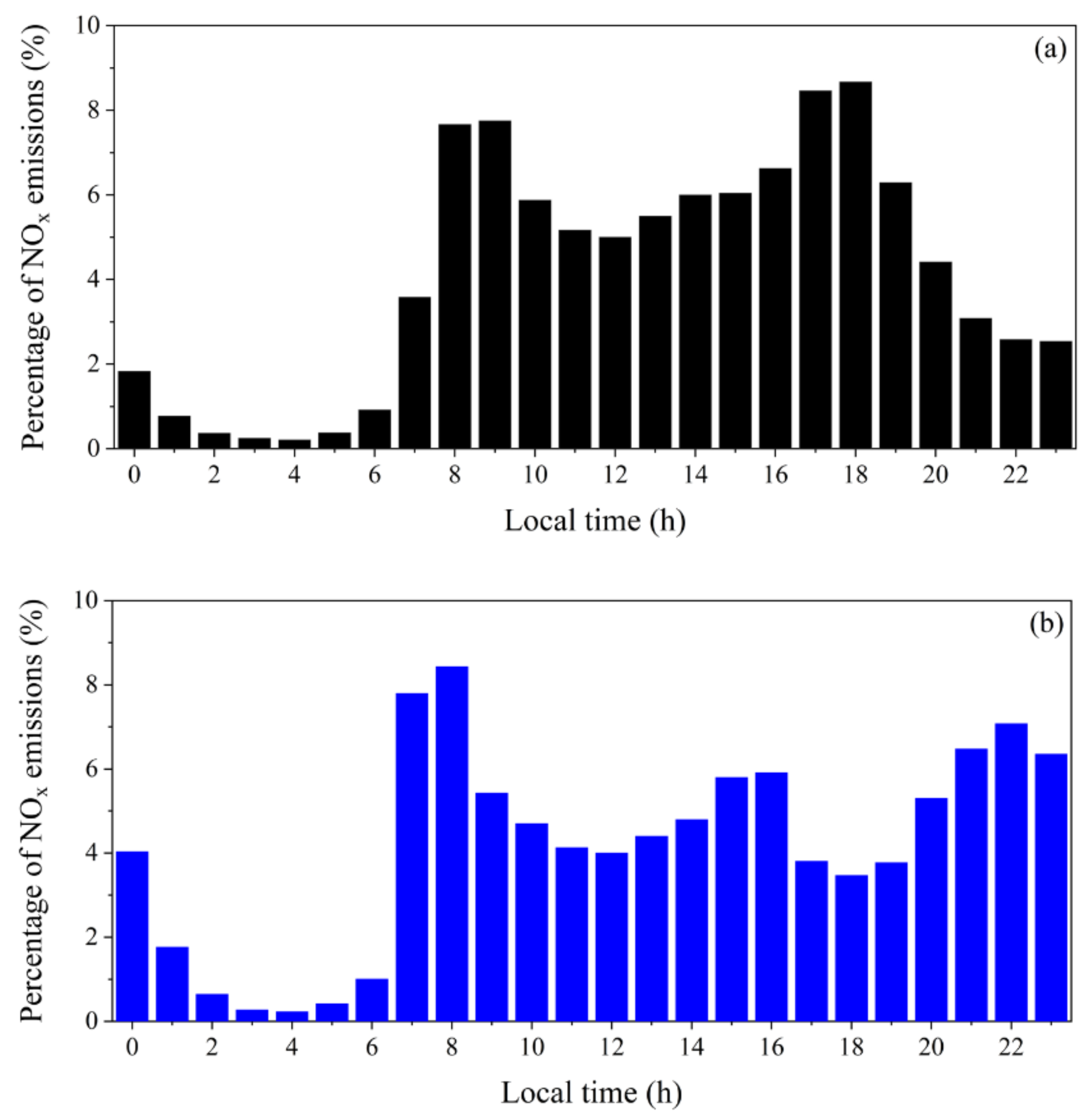
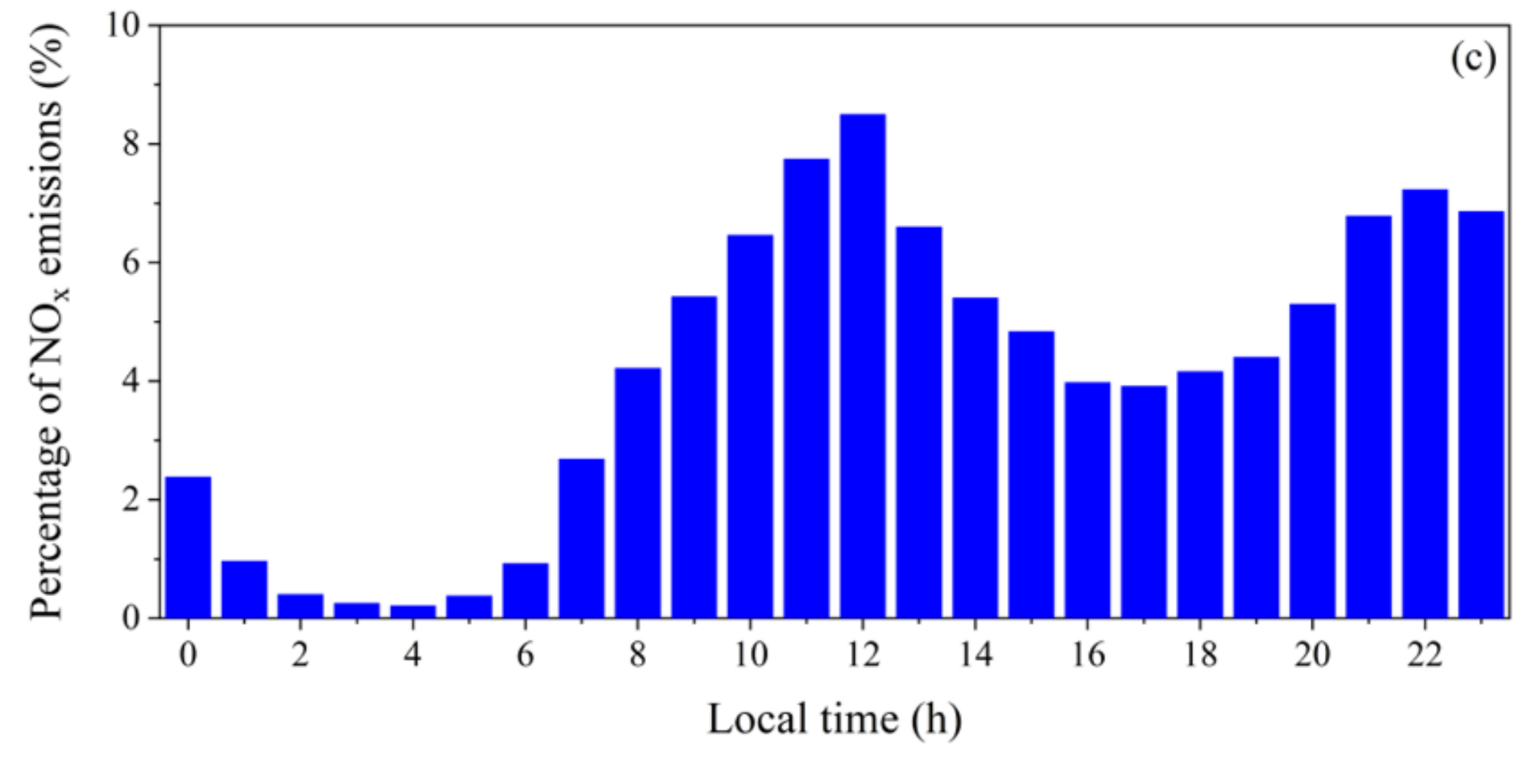
The percentage of the total road surface located in each 1 × 1 km2 grid cell was quantified by the ArcGIS Explorer Desktop (ESRI). Emissions from road transport (SNAP 7) are distributed based on this road surface fraction (Figure 3d). The original emission inventory assumed that the temporal profile of transport emissions is the same for all European countries and that the working hours are from 9 to 5 LT and afterwards (Figure 4a). The Greek working period differs by 1–2 h from the default temporal profile and during the nighttime there is significant traffic as a lot of Greeks go and stay out until late. The temporal distribution of transport emissions for the inner domain has been updated using the diurnal profiles for weekdays and weekends shown in Figure 4.
Shipping emissions (SNAP 99) are equally distributed to the grid cells with shipping lanes (Figure 3e).
Industrial emissions, emissions from power generation, mining, and emissions from related processes (SNAP 1, 3, 4, 5, 6, 9) are included as point emissions and are placed in the corresponding grid cell (Figure 3f).
Cooking organic aerosol (COA) emissions are also included in the urban emission inventory of Patras (Figure 3g). Their spatial distribution is based on the exact locations of all restaurants and grills in the inner domain [64]. Their temporal distribution is also based on the estimates of Siouti et al. [64]. The volatility distribution of Louvaris et al. [65] is used for COA. The same emissions are used every day in this first application of SmartAQ.
Biomass burning organic aerosol (bbOA) emissions from domestic heating are also included (Figure 3h). Wood burning in fireplaces is the dominant source of pollution during cold periods [30,66]. The spatial distribution of bbOA emissions is based on the density of houses in Patras. The temporal distribution is based on field measurements [30] and on the habits of Greek people. The volatility distribution of May et al. [67] is used to describe the aging of primary bbOA emissions. The emissions are used for the winter months and will be discussed in detail in a forthcoming publication.

2.6. Source Apportionment Algorithm

PSAT [38,39,40,41,42,43] is a computationally efficient algorithm, which can track the contributions of different sources to primary and secondary pollutant concentration levels. The main advantage of PSAT is that it does not interfere with the calculations of PMCAMx because it runs in parallel with it. It is computationally efficient because it does not repeat the time-consuming calculations for chemistry and transport. It uses the PMCAMx-estimated rates for these processes. PSAT relies on the fact that the probability of each molecule to get transported from a given source or to react or to get deposited is independent of its source. The apportionment of all the secondary species is based on the apportionment of their precursor gas phase species. For example, the apportionment of sulfate is computed based on the apportionment of SO2. The latest version of PSAT used in this work is consistent with the volatility basis set [42,43].
Seven emission categories are used plus initial and boundary conditions, which are each tracked separately by the model as different “sources”. The seven emission source categories used are: “cooking”, which includes OA emissions from cooking activities, “biomass burning”, “sea salt”, “biogenic”, “transportation”, “ships”, and “other anthropogenic”, which includes anthropogenic sources from non-road transport and agriculture. In this application, all of these correspond to local emissions in the inner simulation domain. The “source” of boundary conditions includes everything that is transported from regions outside of the inner domain of Patras. Therefore, PSAT currently calculates the local contributions by each local source and groups all the transported emissions.

3. Results

3.1. PM2.5 Predictions

As an example of the SmartAQ application, PM2.5 predictions are presented for a summer (July 2021) and a winter month (December 2021) focusing on an urban and a suburban site in Patras. During these months the behavior of pollutants differs due to different weather conditions and emission sources. During summer, cooking is the dominant local source of fine PM [64]. During the colder months, wood burning for residential heating is the most important source of PM in Greek cities such as Patras [30].
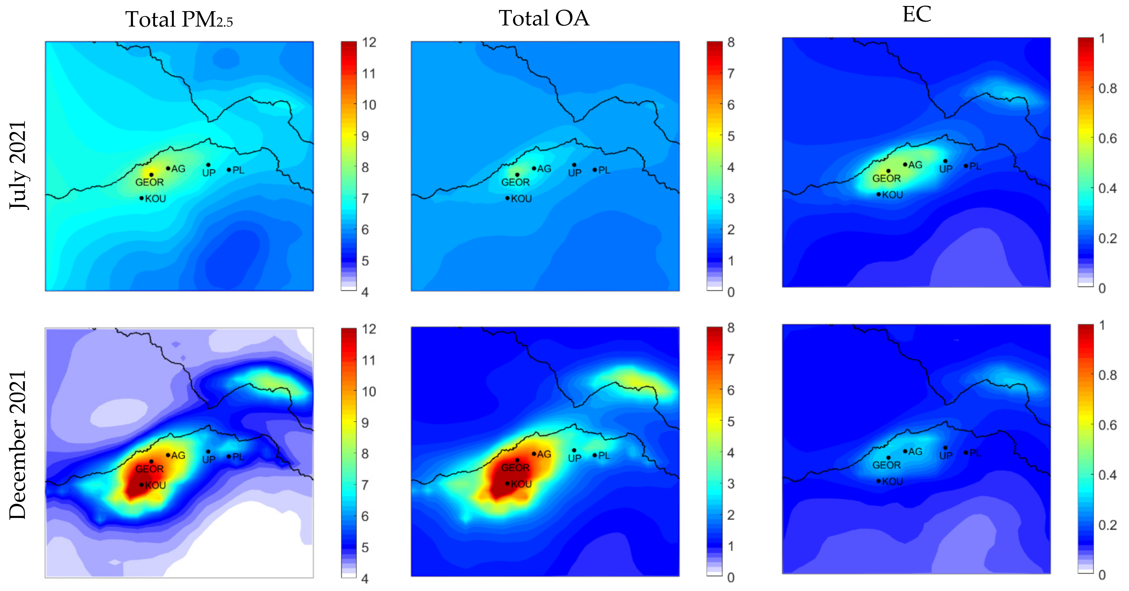
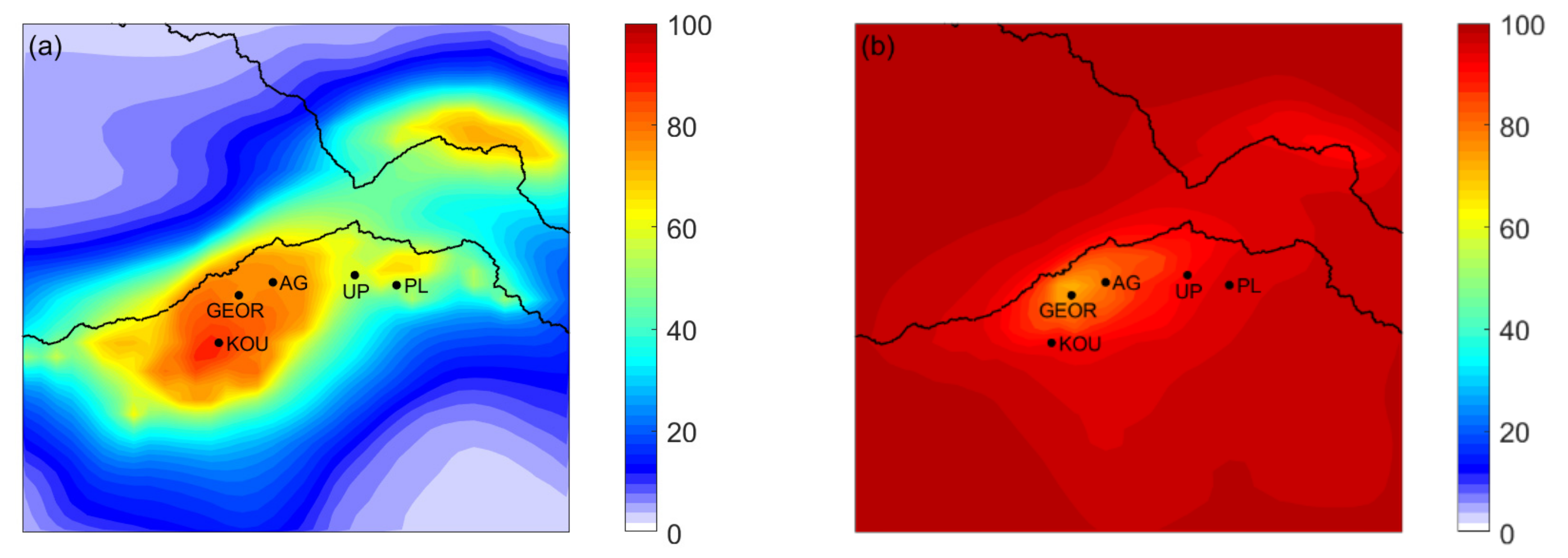
Average ground concentrations of predicted PM2.5 during July and December 2021 are shown in Figure 5. During the summer month, the system predicted average PM2.5 concentration of approximately 9 μg m−3 in the city center (Georgiou Sq.) and 6.5 μg m−3 at the suburbs (Platani), while the corresponding concentrations during winter were close to 11.5 and 5.5 μg m−3, respectively. The higher PM2.5 concentrations in the urban core during December 2021 are related to biomass burning for domestic heating, which is the dominant source of particulate pollution during this period, while during summer, PM2.5 is coming mainly from long-range transport (Figure 6a,b). PM2.5 from domestic heating contributes 53% to the total PM2.5 in Georgiou Sq. during the winter month, while the corresponding contribution of PM2.5 from long-range transport is 70% during summer.
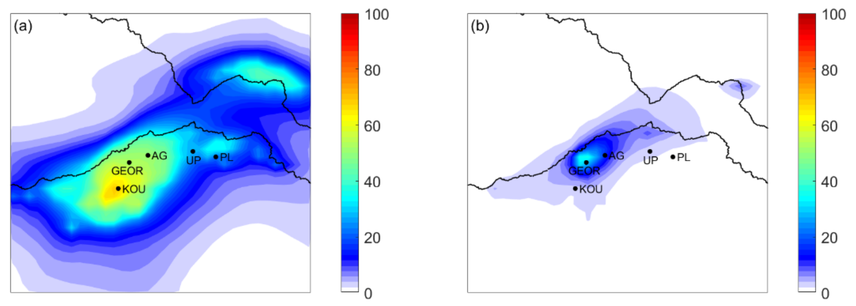
During summertime, average PM2.5 OA levels of 3.8 μg m−3 were predicted in the city center and 2 μg m−3 at the suburbs of the city (Figure 5). During wintertime, the corresponding concentrations are 8 and 2.3 μg m−3. The difference in concentrations in the city center is related to primary biomass burning OA emissions that are not present in the summer. During winter, 76% of the PM2.5 OA in the city center is due to biomass burning (Figure 7a), while during the summertime, cooking OA contributes 36% to the total PM2.5 OA in Georgiou Sq. (Figure 7b).
Fine elemental carbon (EC) concentrations were predicted to be lower than 1 μg m−3 for both periods (Figure 5). Elemental carbon concentrations are higher in the city center than at the suburbs as the corresponding emissions are related to transport. During July, in the city center, 28% of elemental carbon is coming from long-range transport according to SmartAQ, 35% from transportation and 37% from other sources (Figure S1), while during December, the contributions are 35%, 26% and 39%, respectively (Figure S2).
Average PM2.5 sulfate concentrations do not have significant variability in space (Figure 8). During summer the predicted concentrations are close to 2.5 μg m−3 both in the city center and at the suburbs, while during winter the predicted concentrations are approximately 50% of the summer ones. This low spatial variability is expected most of the sulfate is due to long-range transport and the local contribution is minor.
SmartAQ predicted fine nitrate and ammonium concentrations were lower than 1 μg m−3 for the whole inner domain during the two periods (Figure 8). Average nitrate concentration of 0.32 μg m−3 was predicted in both sites during December 2021, while 0.30 μg m−3 was predicted in Georgiou Sq. and 0.22 μg m−3 in Platani during July 2021. For ammonium SmartAQ predicted 0.74 μg m−3 in the city center and at the suburbs during summertime and 0.43 μg m−3 in both sites during winter.
Average ground concentrations of secondary OA are predicted to be higher during the summertime and equal to 1 μg m−3 (Figure S3). Organic aerosol from long-range-transport dominates the OA concentrations for both periods, while OA from the oxidation of IVOCs and SVOCS is the most important component of secondary OA in the inner domain including Patras (Figures S4 and S5).
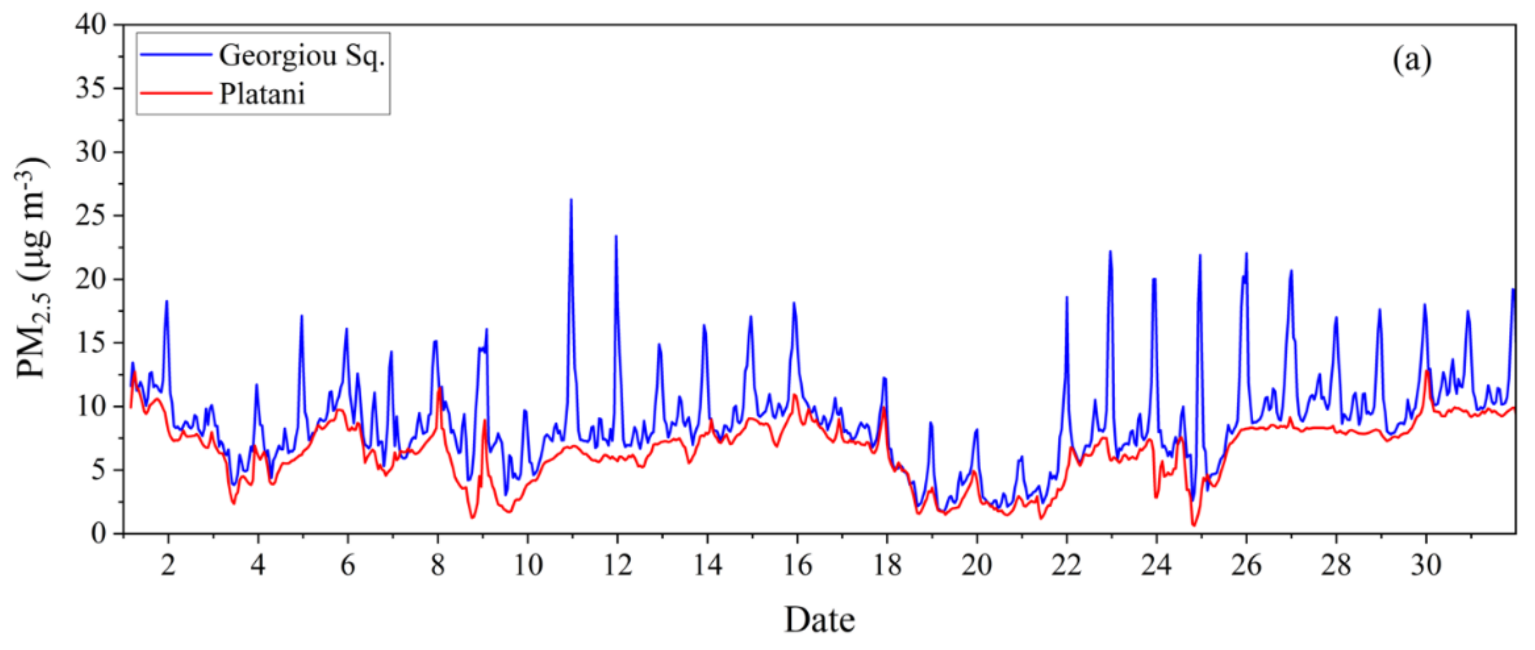
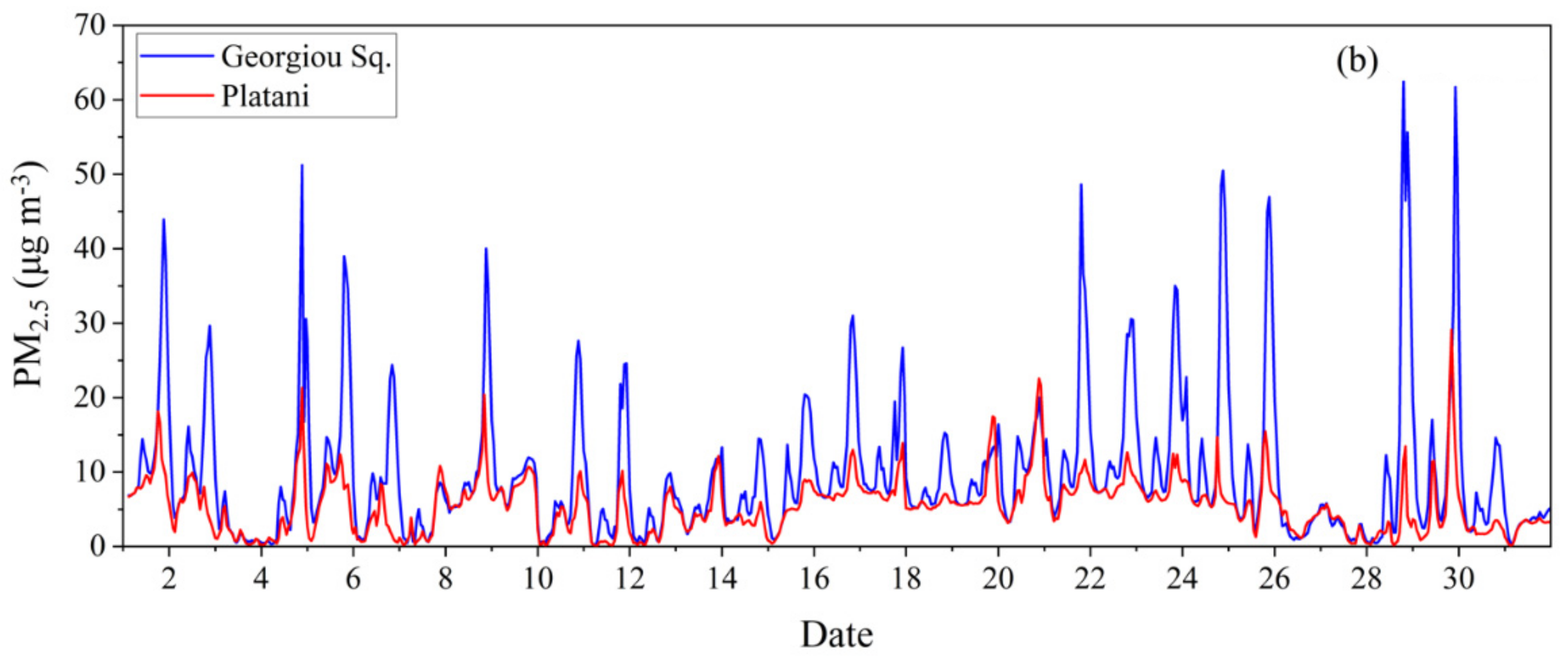
During the summertime, in the city center, SmartAQ predicts PM2.5 concentrations up to 25 μg m−3 during the nighttime (Figure 9a). Smaller peaks are also predicted early in the morning and during the noon. For the winter period, the predicted PM2.5 concentrations are much higher with nighttime peaks this time up to 60 μg m−3 (Figure 9b). These peaks during winter are related to domestic biomass burning emissions, while during summer to cooking and transportation emissions. At the suburbs of the city (Platani), the predicted concentrations are lower than in the city center for both periods as there are no significant sources of PM in that background site and the concentrations are mainly due to transport from nearby urban areas (Figure 9).
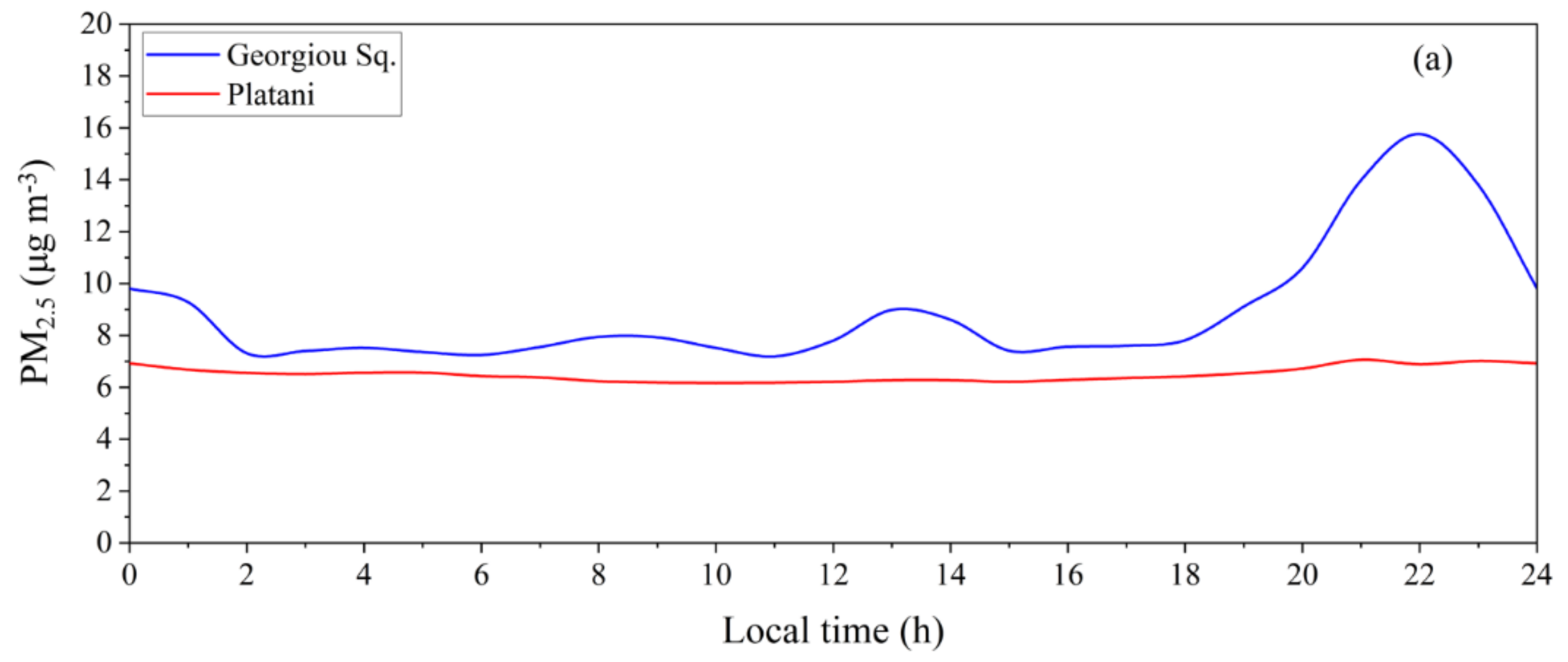
The predicted average PM2.5 diurnal profile in Georgiou Sq. and Platani during July and December 2021 are shown in Figure 10. During the summer, a high peak was predicted in the city center at night, from 21:00 LT to midnight, close to 16 μg m−3, due to cooking and transport, while a smaller peak of 8 μg m−3 was predicted in the morning, at approximately 8:00 LT, due to traffic (Figure 10a). Another small peak of approximately 9 μg m−3 is predicted at noon mainly due to cooking emissions. The average diurnal profile of PM2.5 source contributions in the city center are shown in Figure S6a. At the suburbs of the city, the average diurnal profile is relatively flat as expected, and the average concentrations are lower than the city center (Figure 10a). PM2.5 from long-range transport is the main source of pollution at this site (Figure S6b).
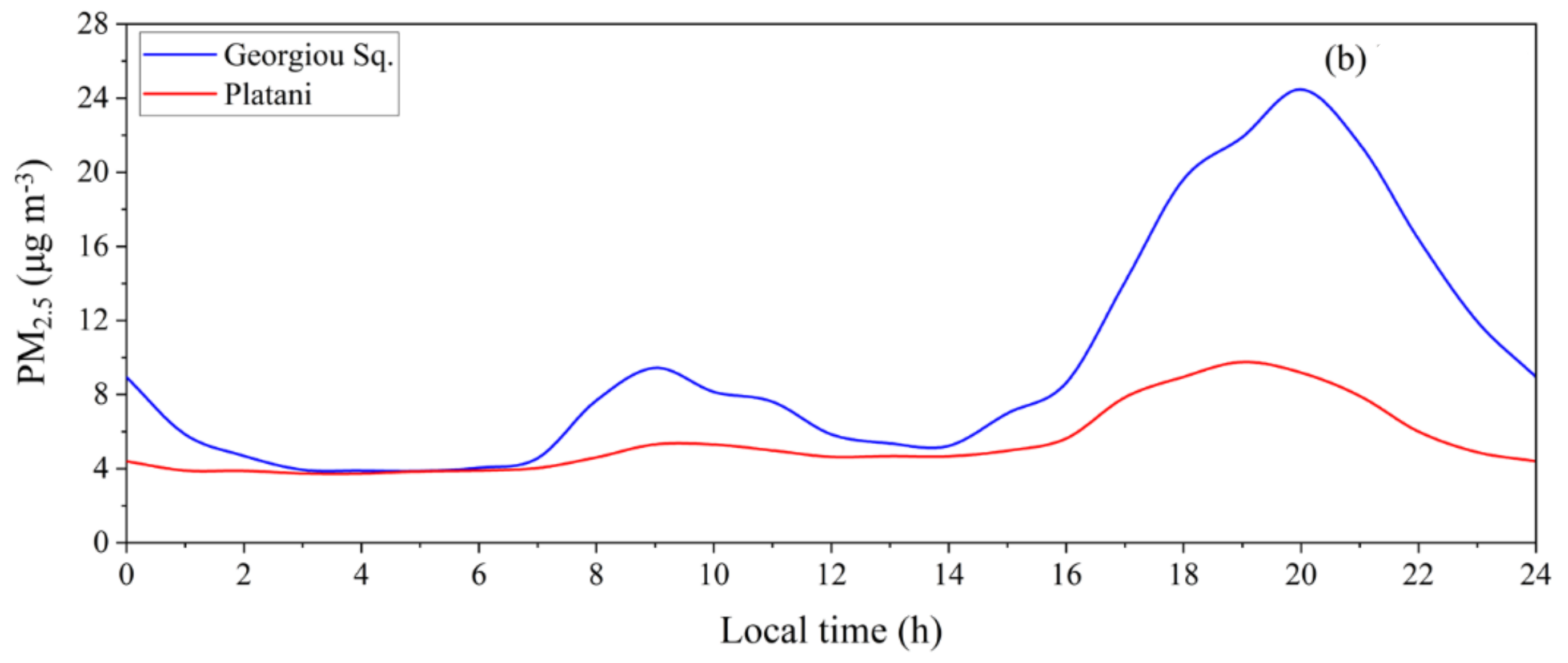
During the wintertime, in the city center, SmartAQ predicted a high peak close to 25 μg m−3 at approximately 20:00 LT, due to residential biomass burning, and a smaller peak early in the morning due to transportation and biomass burning (Figure 10b). The corresponding average diurnal profile of source contributions of fine PM in Georgiou Sq. are shown in Figure S7a. In Platani, the corresponding concentrations are much lower and there is only a small peak early at night related to residential biomass burning in the nearby areas (Figure 10b and Figure S7b).

3.2. Predictions for Gas-Phase Pollutants

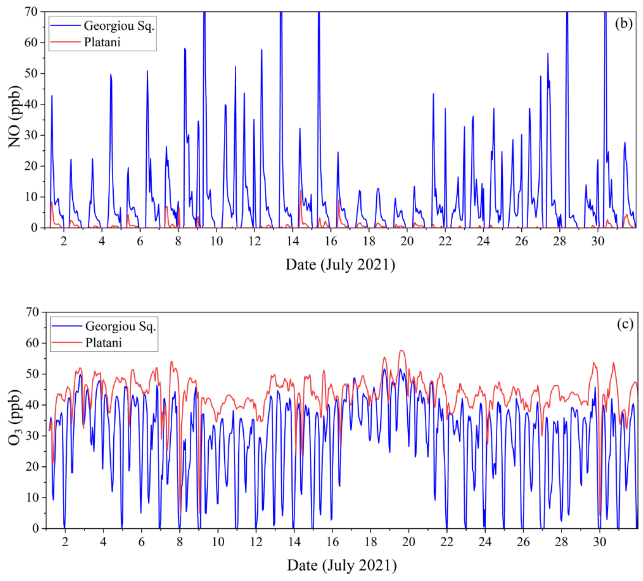
Average predicted ground concentrations of NO2, NO and O3 during July 2021 are shown in Figure 11. The SmartAQ system predicted average NO2 and NO concentrations of 18 and 6 ppb in Georgiou Sq. and 2.5 and 0.4 ppb in Platani, respectively. On the other hand, O3 was predicted to be 31 ppb in the city center and 43 ppb at the suburbs.
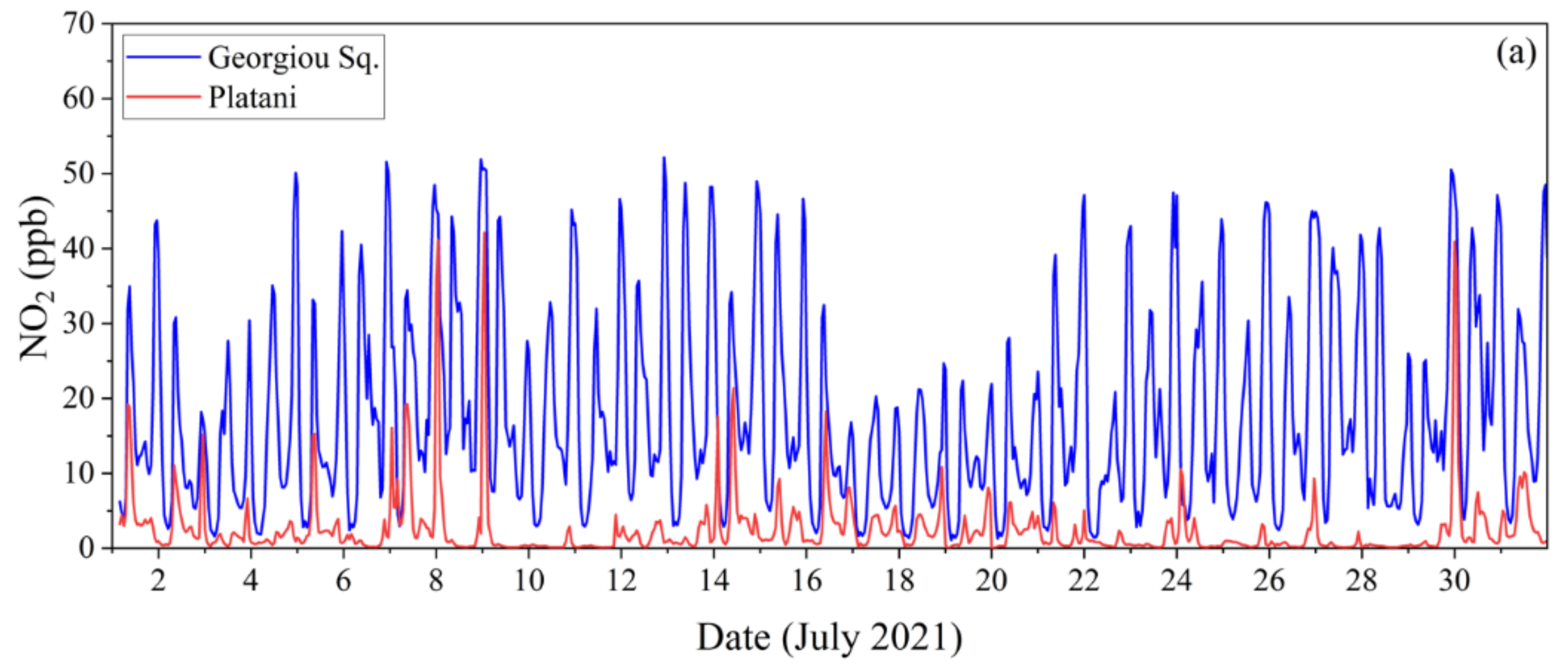
NO2, NO, and O3 hourly predictions for July 2021 are shown in Figure 12 for the city center and the suburbs. For NOx, the system predicts high peaks early in the morning, from 7:00 to 8:00 LT, mainly in the city center and at night, from 22:00 to 23:00 LT, as NOx is emitted mainly from transportation, which is higher during those hours (Figure 12a,b). Predicted NOx concentrations are as expected higher in the city center, in Georgiou Square. Additionally, ozone is low when the NOx concentrations are high (Figure 12c).

4. Discussion

Τhe SmartAQ forecasting system can predict the concentration of the various air pollutants and their sources as a function of space and time for the next three days. The prediction of the sources of all pollutants, its detailed emission inventory including cooking and residential biomass burning, the low computational requirements and its high spatial resolution are some of its main advantages.
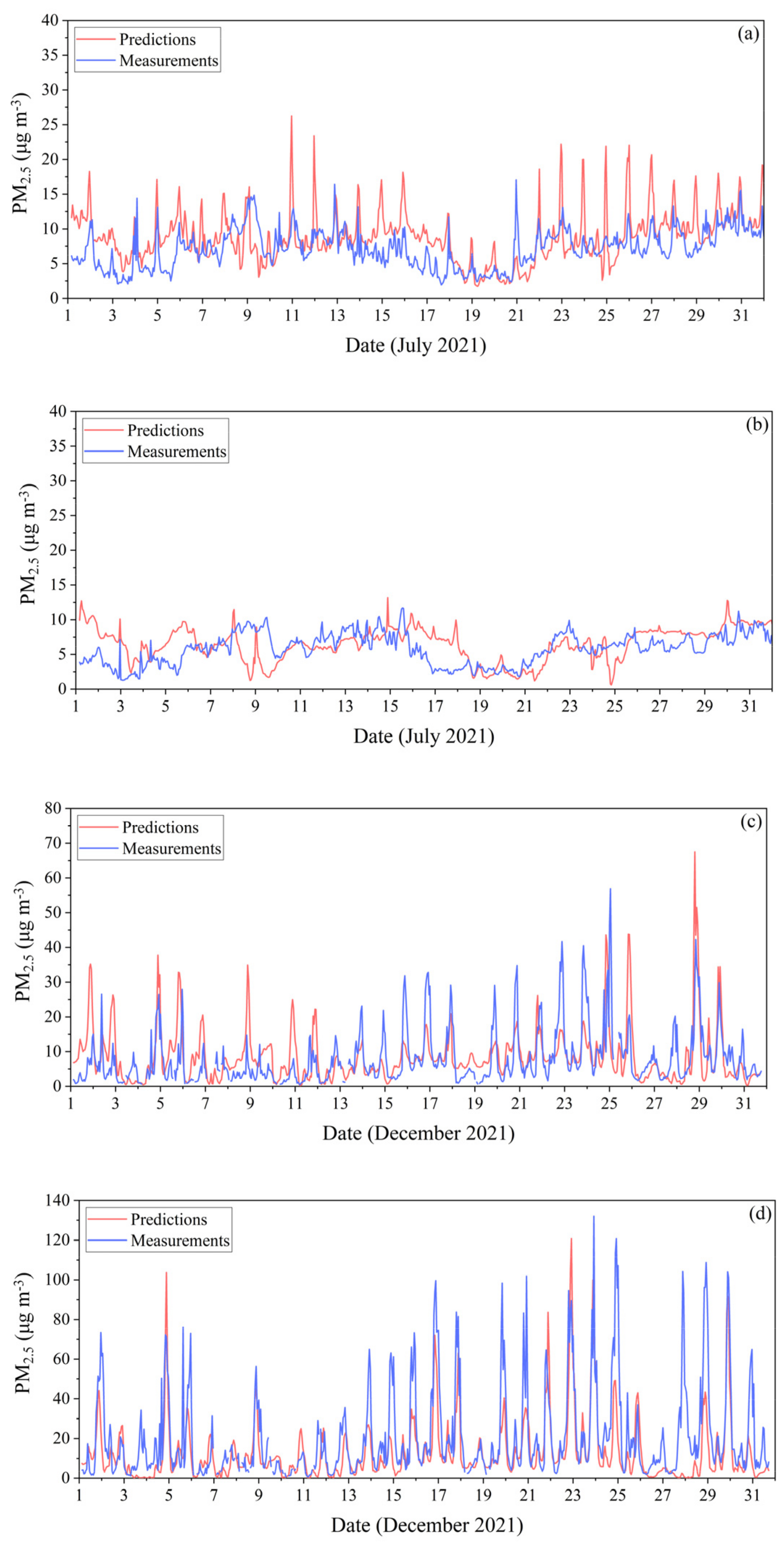
Indicative comparisons of the measured and predicted PM2.5 for four sites in Patras are shown in Figure 13. The measurements are from a low-cost sensor network operating in the city. During the summertime, in the city center (Georgiou Sq.), predictions follow the behavior of measurements that peak during the nights mainly due to cooking emissions [29,64], while at the suburbs (Platani) measurements and predictions are similar and much lower than the city center, indicating the ability of SMARTAQ to capture these gradients in space over a few kilometers. For the city center, the fractional bias and fractional error were equal to 0.19 and 0.36, while for the suburbs 0.09 and 0.38, respectively, indicating good performance of the system [68]. The mean observed and the mean predicted PM2.5 concentrations are 7.2 and 8.8 μg m−3 for the city center and 5.8 and 6.4 μg m−3 for the suburbs.
For the winter period, comparisons of measured and predicted PM2.5 are presented for Agia and Kypseli. The locations of the two sites are shown in Figure 2. For both sites, high peaks were observed from early in the evening until midnight due to wood burning for domestic heating [30]. SMARTAQ was able to predict those peaks during the nighttime attributing them to residential heating (Figure S7). For the Agia site, the fractional bias and fractional error are equal to 0.13 and 0.64, while for Kypseli are −0.4 and 0.7, respectively, indicating average performance of the model [68]. The mean observed and predicted PM2.5 were 8 and 8.9 μg m−3 for Agia and 20 and 13.5 μg m−3 for Kypseli.
In general, the system predicts the nighttime peaks during both periods and the overall behavior of measurements. It tends slightly to overpredict the summertime concentrations for those places, while during the winter the predictions are encouraging with room for improvement mainly for biomass burning emissions for domestic heating. A review of high-resolution emissions could be helpful for future research. Discrepancies between measurements and predictions can be also linked to meteorological inputs and to uncertainties of low-cost sensor measurements.

5. Conclusions

An operational urban air quality prediction system that provides real-time forecasts of tens of gas and particle phase atmospheric pollutants was developed. The system is in operation from March 2021 and produces predictions every day for the next three-day period. The city of Patras in Greece has been used for the first applications. The predictions are available online (aqmmon.iceht.forth.gr, accessed on 14 September 2022).
The main advantages of SmartAQ are its high spatial resolution of 1 × 1 km2 for the urban area, the improved local anthropogenic emission inventory that includes also cooking and residential biomass burning emissions and the treatment of SOA formation that considers the volatility of POA emissions, and its ability to forecast the source contributions for each primary and secondary pollutant. The new forecasting system combines state-of-the-art models to produce weather and air quality predictions, but also biogenic and sea-spray aerosol emissions. SmartAQ is configured in four two-way nests that start from the European domain at 36 × 36 km2 and gradually zoom in the desired urban area with a high spatial resolution of 1 × 1 km2. The developed air quality forecasting system can be applied to any European urban area to produce high-resolution atmospheric and weather predictions.
The evaluation of these predictions against measurements obtained from the low-cost particle measurement network will be described further in future work.

Supplementary Materials

The following supporting information can be downloaded at: https://www.mdpi.com/article/10.3390/atmos13101693/s1, Table S1: Individual compounds simulated by the MEGAN; Figure S1: Contribution (%) of fine EC (a) from LRT, (b) from transportation and (c) from other sources to total fine EC during July 2021 for the domain of Patras; Figure S2: Contribution (%) of fine EC (a) from LRT, (b) from transportation and (c) from other sources to total fine EC during December 2021 for the domain of Patras; Figure S3: Predicted average ground concentrations (μg m−3) of fine secondary OA during (a) July 2021 and (b) December 2021 for the urban domain of Patras at 1 × 1 km2 resolution; Figure S4: Contribution (%) of (a) LRT, (b) oxidized, (c) anthropogenic and (d) biogenic fine secondary OA to total fine secondary OA during July 2021 for the urban domain; Figure S5: Contribution (%) of (a) LRT, (b) oxidized, (c) anthropogenic and (d) biogenic fine secondary OA to total fine secondary OA during December 2021 for the urban domain; Figure S6: Average diurnal profile of PM2.5 sources in (a) Georgiou Sq. and (b) Platani during July 2021 for the urban domain of Patras; Figure S7: Average diurnal profile of PM2.5 sources in (a) Georgiou Sq., (b) Platani, (c) Agia and (d) Kypseli during December 2021 for the urban domain of Patras.

Author Contributions

E.S., K.S. and I.K. carried out the simulations, E.S. carried out the analysis, E.S. wrote the final manuscript with support from S.N.P., K.S., I.K., D.P. and G.F. and S.N.P. supervised and coordinated the work. All authors provided critical feedback and helped shape the research, analysis, and manuscript. All authors have read and agreed to the published version of the manuscript.

Funding

This work was supported by the EU H2020 RI-URBANS project (grant 101036245).

Institutional Review Board Statement

Not applicable.

Informed Consent Statement

Not applicable.

Data Availability Statement

The model results used in the present study are available upon request ([email protected]).

Conflicts of Interest

The authors declare no conflict of interest.

References

  1. Brugha, R.; Grigg, J. Urban air pollution and respiratory infections. Paediatr. Respir. Rev. 2014, 15, 194–199. [Google Scholar] [CrossRef] [PubMed]
  2. Du, Y.; Xu, X.; Chu, M.; Guo, Y.; Wang, J. Air particulate matter and cardiovascular disease: The epidemiological, biomedical and clinical evidence. J. Thorac. Dis. 2016, 8, 8–19. [Google Scholar]
  3. World Health Organization (WHO). Fact Sheet: Ambient (Outdoor) Air Pollution. 2021. Available online: https://www.who.int/news-room/fact-sheets/detail/ambient-(outdoor)-air-quality-and-health/ (accessed on 3 September 2022).
  4. Boningari, T.; Smirniotis, P.G. Impact of nitrogen oxides on the environment and human health: Mn-based materials for the NOx abatement. Curr. Opin. Chem. Eng. 2016, 13, 133–141. [Google Scholar] [CrossRef]
  5. Kukkonen, J.; Olsson, T.; Schultz, D.M.; Baklanov, A.; Klein, T.; Miranda, A.I.; Monteiro, A.; Hirtl, M.; Tarvainen, V.; Boy, M.; et al. A review of operational, regional-scale, chemical weather forecasting models in Europe. Atmos. Chem. Phys. 2012, 12, 1–87. [Google Scholar]
  6. Kaya, K.; Öğüdücü, S.G. Deep Flexible Sequential (DFS) model for air pollution forecasting. Sci. Rep. 2020, 10, 3346. [Google Scholar] [CrossRef] [Green Version]
  7. Delle Monache, L.; Alessandrini, S.; Djalalova, I.; Wilczak, J.; Knievel, J.C.; Kumar, R. Improving air quality predictions over the United States with an analog ensemble. Weather Forecast. 2020, 35, 2145–2162. [Google Scholar] [CrossRef] [Green Version]
  8. Hamill, T.M.; Whitaker, J.S. Probabilistic quantitative precipitation forecasts based on reforecast analogs: Theory and application. Mon. Weather Rev. 2006, 134, 3209–3229. [Google Scholar] [CrossRef]
  9. Pappa, A.; Kioutsioukis, I. Forecasting particulate pollution in an urban area: From Copernicus to sub-km scale. Atmosphere 2021, 12, 881. [Google Scholar] [CrossRef]
  10. Zhang, Y.; Bocquet, M.; Mallet, V.; Seigneur, C.; Baklanov, A. Real-time air quality forecasting, part I: History, techniques, and current status. Atmos. Environ. 2012, 60, 632–655. [Google Scholar] [CrossRef]
  11. Marécal, V.; Peuch, V.-H.; Andersson, C.; Andersson, S.; Arteta, J.; Beekmann, M.; Benedictow, A.; Bergström, R.; Bessagnet, B.; Cansado, A.; et al. A regional air quality forecasting system over Europe: The MACC-II daily ensemble production. Geosci. Model Dev. 2015, 8, 2777–2813. [Google Scholar] [CrossRef] [Green Version]
  12. CAMS. Regional Production, Updated Documentation Covering All Regional Operational Systems and the ENSEMBLE. ECMWF Copernicus Report. 2020. Available online: https://atmosphere.copernicus.eu/sites/default/files/2020-09/CAMS50_2018SC2_D2.0.2-U2_Models_documentation_202003_v2.pdf (accessed on 3 September 2022).
  13. Rouil, L.; Honoré, C.; Vautard, R.; Beekmann, M.; Bessagnet, B.; Malherbe, L.; Meleux, F.; Dufour, A.; Elichegaray, C.; Flaud, J.M.; et al. PREV’AIR: An operational forecasting and mapping system for air quality in Europe. Bull. Am. Meteorol. Soc. 2009, 90, 73–83. [Google Scholar] [CrossRef] [Green Version]
  14. Lee, K.; Yu, J.; Lee, S.; Park, M.; Hong, H.; Park, S.Y.; Choi, M.; Kim, J.; Kim, Y.; Woo, J.-H.; et al. Development of Korean Air Quality Prediction System version 1 (KAQPS v1) with focuses on practical issues. Geosci. Model Dev. 2020, 13, 1055–1073. [Google Scholar] [CrossRef]
  15. Brasseur, G.P.; Xie, Y.; Petersen, A.K.; Bouarar, I.; Flemming, J.; Gauss, M.; Jiang, F.; Kouznetsov, R.; Kranenburg, R.; Mijling, B.; et al. Ensemble forecasts of air quality in eastern China–Part 1: Model description and implementation of the MarcoPolo-Panda prediction system, version 1. Geosci. Model Dev. 2019, 12, 33–67. [Google Scholar] [CrossRef] [Green Version]
  16. Katragkou, E.; Kioutsioukis, I.; Poupkou, A.; Lisaridis, I.; Markakis, K.; Karathanasis, S.; Melas, D.; Balis, D. An air quality study for Greece with the MM5/CAMx modelling system. In Proceedings of the Electronic ‘Envisat Symposium 2007′, Montreux, Switzerland, 23–27 April 2007. [Google Scholar]
  17. Donahue, N.M.; Robinson, A.L.; Stanier, C.O.; Pandis, S.N. Coupled partitioning, dilution, and chemical aging of semivolatile organics. Environ. Sci. Technol. 2006, 40, 2635–2643. [Google Scholar] [CrossRef]
  18. Robinson, A.L.; Donahue, N.M.; Shrivastava, M.K.; Weitkamp, E.A.; Sage, A.M.; Grieshop, A.P.; Lane, T.E.; Pierce, J.R.; Pandis, S.N. Rethinking organic aerosols: Semivolatile emissions and photochemical aging. Science 2007, 315, 1259–1262. [Google Scholar] [CrossRef]
  19. Murphy, B.N.; Donahue, N.M.; Robinson, A.L.; Pandis, S.N. A naming convention for atmospheric organic aerosol. Atmos. Chem. Phys. 2014, 14, 5825–5839. [Google Scholar] [CrossRef] [Green Version]
  20. Bergström, R.; Denier van der Gon, H.A.C.; Prévôt, A.S.H.; Yttri, K.E.; Simpson, D. Modelling of organic aerosols over Europe (2002–2007) using a volatility basis set (VBS) framework: Application of different assumptions regarding the formation of secondary organic aerosol. Atmos. Chem. Phys. 2012, 12, 8499–8527. [Google Scholar] [CrossRef] [Green Version]
  21. Li, Y.P.; Elbern, H.; Lu, K.D.; Friese, E.; Kiendler-Scharr, A.; Mentel, T.F.; Wang, X.S.; Wahner, A.; Zhang, Y.H. Updated aerosol module and its application to simulate secondary organic aerosols during IMPACT campaign May 2008. Atmos. Chem. Phys. 2013, 13, 6289–6304. [Google Scholar] [CrossRef] [Green Version]
  22. Simpson, D.; Benedictow, A.; Berge, H.; Bergström, R.; Emberson, L.D.; Fagerli, H.; Flechard, C.R.; Hayman, G.D.; Gauss, M.; Jonson, J.E.; et al. The EMEP MSC-W chemical transport model–technical description. Atmos. Chem. Phys. 2012, 12, 7825–7865. [Google Scholar] [CrossRef] [Green Version]
  23. Hodzic, A.; Kasibhatla, P.S.; Jo, D.S.; Cappa, C.D.; Jimenez, J.L.; Madronich, S.; Park, R.J. Rethinking the global secondary organic aerosol (SOA) budget: Stronger production, faster removal, shorter lifetime. Atmos. Chem. Phys. 2016, 16, 7917–7941. [Google Scholar] [CrossRef] [Green Version]
  24. Honoré, C.; Rouil, L.; Vautard, R.; Beekmann, M.; Bessagnet, B.; Dufour, A.; Elichegaray, C.; Flaud, J.-M.; Malherbe, L.; Meleux, F.; et al. Predictability of European air quality: Assessment of 3 years of operational forecasts and analyses by the PREV’AIR system. J. Geophys. Res. 2008, 113, D04301. [Google Scholar] [CrossRef]
  25. Woo, J.-H.; Choi, K.-C.; Kim, H.K.; Baek, B.H.; Jang, M.; Eum, J.-H.; Song, C.H.; Ma, Y.-I.; Sunwoo, Y.; Chang, L.-S.; et al. Development of an anthropogenic emissions processing system for Asia using SMOKE. Atmos. Environ. 2012, 58, 5–13. [Google Scholar] [CrossRef]
  26. Allan, J.D.; Williams, P.I.; Morgan, W.T.; Martin, C.L.; Flynn, M.J.; Lee, J.; Nemitz, E.; Phillips, G.J.; Gallagher, M.W.; Coe, H. Contributions from transports solid fuel burning, and cooking to primary organic aerosols in two UK cities. Atmos. Chem. Phys. 2010, 10, 647–668. [Google Scholar] [CrossRef] [Green Version]
  27. Mohr, C.; DeCarlo, P.F.; Heringa, M.F.; Chirico, R.; Slowik, J.G.; Richter, R.; Reche, C.; Alastuey, A.; Querol, X.; Seco, R.; et al. Identification and quantification of organic aerosol from cooking and other sources in Barcelona using aerosol mass spectrometer data. Atmos. Chem. Phys. 2012, 12, 1649–1665. [Google Scholar] [CrossRef] [Green Version]
  28. Crippa, M.; DeCarlo, P.F.; Slowik, J.G.; Mohr, C.; Heringa, M.F.; Chirico, R.; Poulain, L.; Freutel, F.; Sciare, J.; Cozic, J.; et al. Wintertime aerosol chemical composition and source apportionment of the organic fraction in the metropolitan area of Paris. Atmos. Chem. Phys. 2013, 13, 961–981. [Google Scholar] [CrossRef] [Green Version]
  29. Kostenidou, E.; Florou, K.; Kaltsonoudis, C.; Tsiflikiotou, M.; Vratolis, E.; Eleftheriadis, K.; Pandis, S.N. Sources and chemical characterization of organic aerosol during the summer in the eastern Mediterranean. Atmos. Chem. Phys. 2015, 15, 11355–11371. [Google Scholar] [CrossRef] [Green Version]
  30. Florou, K.; Papanastasiou, D.K.; Pikridas, M.; Kaltsonoudis, C.; Louvaris, E.; Gkatzelis, G.I.; Patoulias, D.; Mihalopoulos, N.; Pandis, S.N. The contribution of wood burning and other pollution sources to wintertime organic aerosol levels in two Greek cities. Atmos. Chem. Phys. 2017, 17, 3145–3163. [Google Scholar] [CrossRef] [Green Version]
  31. Skamarock, W.C.; Klemp, J.B.; Dudhia, J.; Gill, D.O.; Liu, Z.; Berner, J.; Wang, W.; Powers, J.G.; Duda, M.G.; Barker, D.M.; et al. A description of the Advanced Research WRF Model Version 4.1; No. NCAR/TN-556+STR; National Center for Atmospheric Research: Boulder, CO, USA, 20 July 2021. [Google Scholar] [CrossRef]
  32. Guenther, A.; Karl, T.; Harley, P.; Wiedinmyer, C.; Palmer, P.I.; Geron, C. Estimates of global terrestrial isoprene emissions using MEGAN (Model of Emissions of Gases and Aerosols from Nature). Atmos. Chem. Phys. 2006, 6, 3181–3210. [Google Scholar] [CrossRef] [Green Version]
  33. Guenther, A.B.; Jiang, X.; Heald, C.L.; Sakulyanontvittaya, T.; Duhl, T.; Emmons, L.K.; Wang, X. The Model of Emissions of Gases and Aerosols from Nature version 2.1 (MEGAN2.1): An extended and updated framework for modeling biogenic emissions. Geosci. Model Dev. 2012, 5, 1471–1492. [Google Scholar] [CrossRef] [Green Version]
  34. O’Dowd, C.D.; Langmann, B.; Varghese, S.; Scannell, C.; Ceburnis, D.; Facchini, M.C. A combined organic-inorganic sea-spray source function. Geophys. Res. Lett. 2008, 35, L01801. [Google Scholar] [CrossRef] [Green Version]
  35. Monahan, E.C.; Spiel, D.E.; Davidson, K.L. A model of marine aerosol generation via whitecaps and wave disruption. In Oceanic Whitecaps; Monahan, E.C., Niocaill, G.M., Eds.; Springer: Dordrecht, The Netherlands, 1986; Volume 2, pp. 167–174. [Google Scholar]
  36. Kuenen, J.J.P.; Visschedijk, A.J.H.; Jozwicka, M.; Denier van der Gon, H.A.C. TNO-MACC_II emission inventory; a multi-year (2003–2009) consistent high-resolution European emission inventory for air quality modelling. Atmos. Chem. Phys. 2014, 14, 10963–10976. [Google Scholar] [CrossRef]
  37. Gaydos, T.M.; Pinder, R.; Koo, B.; Fahey, K.M.; Yarwood, G.; Pandis, S.N. Development and application of a three-dimensional aerosol chemical transport model, PMCAMx. Atmos. Environ. 2007, 41, 2594–2611. [Google Scholar] [CrossRef]
  38. Wagstrom, K.M.; Pandis, S.N.; Yarwood, G.; Wilson, G.M.; Morris, R.E. Development and application of a computationally efficient particulate matter apportionment algorithm in a three-dimensional chemical transport model. Atmos. Environ. 2008, 42, 5650–5659. [Google Scholar] [CrossRef]
  39. Wagstrom, K.M.; Pandis, S.N. Source receptor relationships for fine particulate matter concentrations in the Eastern United States. Atmos. Environ. 2011, 45, 347–356. [Google Scholar] [CrossRef]
  40. Wagstrom, K.M.; Pandis, S.N. Contribution of long-range transport to local fine particulate matter concerns. Atmos. Environ. 2011, 45, 2730–2735. [Google Scholar] [CrossRef]
  41. Skyllakou, K.; Murphy, B.N.; Megaritis, A.G.; Fountoukis, C.; Pandis, S.N. Contributions of local and regional sources to fine PM in the megacity of Paris. Atmos. Chem. Phys. 2014, 14, 2343–2352. [Google Scholar] [CrossRef] [Green Version]
  42. Skyllakou, K.; Fountoukis, C.; Charalampidis, P.; Pandis, S.N. Volatility-resolved source apportionment of primary and secondary organic aerosol over Europe. Atmos. Environ. 2017, 167, 1–10. [Google Scholar] [CrossRef]
  43. Skyllakou, K.; Rivera, P.G.; Dinkelacker, B.; Karnezi, E.; Kioutsioukis, I.; Hernandez, C.; Adams, P.J.; Pandis, S.N. Changes in PM2.5 concentrations and their sources in the US from 1990 to 2010. Atmos. Chem. Phys. 2021, 21, 17115–17132. [Google Scholar] [CrossRef]
  44. Roukounakis, N.; Katsanos, D.; Briole, P.; Elias, P.; Kioutsioukis, I.; Argiriou, A.A.; Retalis, A. Use of GNSS tropospheric delay measurements for the parameterization and validation of WRF high-resolution re-analysis over the Western Gulf of Corinth, Greece: The PaTrop Experiment. Remote Sens. 2021, 13, 1898. [Google Scholar] [CrossRef]
  45. Roukounakis, N.; Elias, P.; Briole, P.; Katsanos, D.; Kioutsioukis, I.; Argiriou, A.A.; Retalis, A. Tropospheric correction of sentinel-1 synthetic aperture radar interferograms using a high-resolution weather model validated by GNSS measurements. Remote Sens. 2021, 13, 2258. [Google Scholar] [CrossRef]
  46. Iacono, M.J.; Delamere, J.S.; Mlawer, E.J.; Shephard, M.W.; Clough, S.A.; Collins, W.D. Radiative forcing by long-lived greenhouse gases: Calculations with the AER radiative transfer models. J. Geophys. Res. 2008, 113, D13103. [Google Scholar] [CrossRef]
  47. Kain, J.S. The Kain–Fritsch convective parameterization: An update. J. Appl. Meteorol. 2004, 43, 170–181. [Google Scholar] [CrossRef]
  48. Hong, S.; Dudhia, J.; Chen, S. A revised approach to ice microphysical processes for the bulk parameterization of clouds and precipitation. Mon. Weather Rev. 2004, 132, 103–120. [Google Scholar] [CrossRef]
  49. Hong, S.; Noh, Y.; Dudhia, J. A new vertical diffusion package with an explicit treatment of entrainment processes. Mon. Weather Rev. 2006, 134, 2318–2341. [Google Scholar] [CrossRef] [Green Version]
  50. Jiménez, P.A.; Dudhia, J.; González-Rouco, J.F.; Navarro, J.; Montávez, J.P.; García-Bustamante, E. A revised scheme for the WRF surface layer formulation. Mon. Weather Rev. 2012, 140, 898–918. [Google Scholar] [CrossRef] [Green Version]
  51. Chen, F.; Dudhia, J. Coupling an advanced land surface-hydrology model with the Penn State-NCAR MM5 modeling system. Part I: Model implementation and sensitivity. Mon. Weather Rev. 2001, 129, 569–585. [Google Scholar] [CrossRef]
  52. Environ. User’s Guide to the Comprehensive Air Quality Model with Extensions (CAMx). Version 6.0. ENVIRON International Corporation. 2013. Available online: https://camx-wp.azurewebsites.net/Files/CAMxUsersGuide_v6.00.pdf (accessed on 3 September 2022).
  53. Carter, W.P.L. 2000. Documentation of the SAPRC-99 Chemical Mechanism for VOC Reactivity Assessment. Report to California Air Resources Board. Available online: https://intra.engr.ucr.edu/~carter/absts.htm#saprc99 (accessed on 3 September 2022).
  54. Fahey, K.M.; Pandis, S.N. Optimizing model performance: Variable size resolution in cloud chemistry modeling. Atmos. Environ. 2001, 35, 4471–4478. [Google Scholar] [CrossRef]
  55. Capaldo, K.P.; Pilinis, C.; Pandis, S.N. A computationally efficient hybrid approach for dynamic gas/aerosol transfer in air quality models. Atmos. Environ. 2000, 34, 3617–3627. [Google Scholar] [CrossRef]
  56. Seinfeld, J.H.; Pandis, S.N. Atmospheric Chemistry and Physics: From Air Pollution to Climate Change, 3rd ed.; John Wiley & Sons: Hoboken, NJ, USA, 2016. [Google Scholar]
  57. Wesely, M.L. Parameterization of surface resistances to gaseous dry deposition in regional-scale numerical models. Atmos. Environ. 1989, 23, 1293–1304. [Google Scholar] [CrossRef]
  58. Slinn, S.A.; Slinn, W.G.N. Predictions for particle deposition on natural waters. Atmos. Environ. 1980, 14, 1013–1016. [Google Scholar] [CrossRef]
  59. Tsimpidi, A.P.; Karydis, V.A.; Zavala, M.; Lei, W.; Molina, L.; Ulbrich, I.M.; Jimenez, J.L.; Pandis, S.N. Evaluation of the volatility basis-set approach for the simulation of organic aerosol formation in the Mexico City metropolitan area. Atmos. Chem. Phys. 2010, 10, 525–546. [Google Scholar] [CrossRef]
  60. Gaydos, T.M.; Koo, B.; Pandis, S.N.; Chock, D.P. Development and application of an efficient moving sectional approach for the solution of the atmospheric aerosol condensation/evaporation equations. Atmos. Environ. 2003, 37, 3303–3316. [Google Scholar] [CrossRef]
  61. Koo, B.; Gaydos, T.M.; Pandis, S.N. Evaluation of the equilibrium, dynamic, and hybrid aerosol modeling approaches. Aerosol Sci. Technol. 2003, 37, 53–64. [Google Scholar] [CrossRef]
  62. Koo, B.Y.; Ansari, A.S.; Pandis, S.N. Integrated approaches to modeling the organic and inorganic atmospheric aerosol components. Atmos. Environ. 2003, 37, 4757–4768. [Google Scholar] [CrossRef]
  63. Greek Government Gazette. 2021. Available online: www.et.gr/api/DownloadFeksApi/?fek_pdf=20210200182 (accessed on 3 September 2022).
  64. Siouti, E.; Skyllakou, K.; Kioutsioukis, I.; Ciarelli, G.; Pandis, S.N. Simulation of the cooking organic aerosol concentration variability in an urban area. Atmos. Environ. 2021, 265, 118710. [Google Scholar] [CrossRef]
  65. Louvaris, E.E.; Karnezi, E.; Kostenidou, E.; Kaltsonoudis, C.; Pandis, S.N. Estimation of the volatility distribution of organic aerosol combining thermodenuder and isothermal dilution measurements. Atmos. Meas. Tech. 2017, 10, 3909–3918. [Google Scholar] [CrossRef] [Green Version]
  66. Pikridas, M.; Tasoglou, A.; Florou, K.; Pandis, S.N. Characterization of the origin of fine particulate matter in a medium size urban area in the Mediterranean. Atmos. Environ. 2013, 80, 264–274. [Google Scholar] [CrossRef]
  67. May, A.A.; Levin, E.J.T.; Hennigan, C.J.; Riipinen, I.; Lee, T.; Collett, J.L.; Jimenez, J.L.; Kreidenweis, S.M.; Robinson, A.L. Gas-particle partitioning of primary organic aerosol emissions: 3. Biomass burning. J. Geophys. Res. 2013, 118, 11327–11338. [Google Scholar] [CrossRef]
  68. Morris, R.E.; McNally, D.E.; Tesche, T.W.; Tonnesen, G.; Boylan, J.W.; Brewer, P. Preliminary Evaluation of the Community Multiscale Air Quality Model for 2002 over the Southeastern United States. J. Air Waste Manag. 2005, 55, 1694–1708. [Google Scholar] [CrossRef]
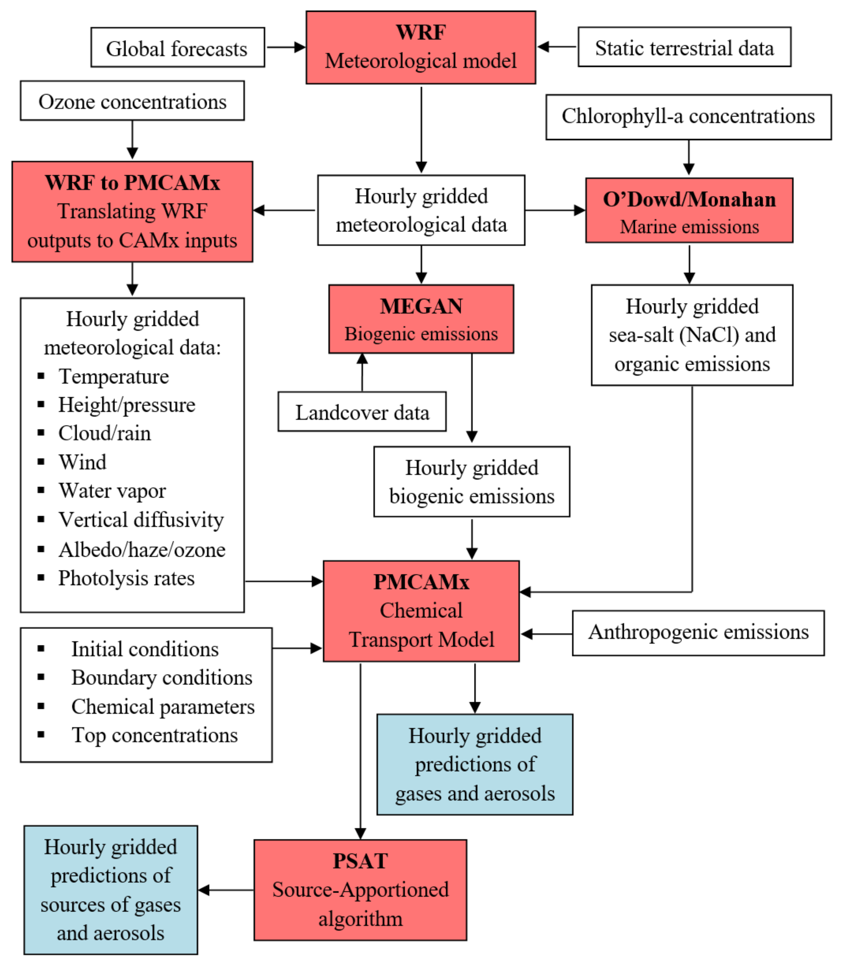
Figure 1. Simplified flow chart for SmartAQ. The modules used are in red boxes. Inputs and outputs of modules are in white boxes. Main outputs for pollutant predicted concentrations are in blue boxes.
Atmosphere 13 01693 g001
Figure 2. (a) The European domain with 36 × 36 km2 resolution (d01), (b) the nested domains with increasing spatial resolution, 12 × 12 (red) (d02), 3 × 3 (blue) (d03) and 1 × 1 (green) (d04) km2 and (c) locations of the discussed sites in the city of Patras.
Atmosphere 13 01693 g002
Figure 3. Total PM10 emissions (tn km−2) from (a) agriculture, (b) domestic processes, (c) non-road transport, (d) road transport, (e) shipping, (f) industry, (g) cooking and (h) biomass burning during December 2021 for the inner domain including the city of Patras. Different scales are used.
Atmosphere 13 01693 g003aAtmosphere 13 01693 g003b
Figure 4. Temporal distribution of transport emissions from: (a) the original emission inventory, (b) the urban inventory for weekdays and (c) the urban inventory for weekends.
Atmosphere 13 01693 g004aAtmosphere 13 01693 g004b
Figure 5. Predicted average ground concentrations (μg m−3) of total PM2.5, total fine OA and fine elemental carbon (EC) during July and December 2021 for the inner domain including Patras at 1 × 1 km2 resolution. Different scales are used.
Atmosphere 13 01693 g005
Figure 6. Contribution (%) of PM2.5 from: (a) residential biomass burning to total PM2.5 during December 2021 and (b) LRT to total PM2.5 during July 2021 for the inner domain including Patras.
Atmosphere 13 01693 g006
Figure 7. Contribution (%) of fine (a) bbOA to total fine OA during December 2021 and (b) COA to total fine OA during July 2021 for the inner domain including Patras.
Atmosphere 13 01693 g007
Figure 8. Predicted average ground concentrations (μg m−3) of PM2.5 sulfate, nitrate and ammonium during July and December 2021 for the inner domain including Patras at 1 × 1 km2 resolution. Different scales are used.
Atmosphere 13 01693 g008
Figure 9. Predicted time series for PM2.5 during (a) July 2021 and (b) December 2021 in Georgiou Sq. (center of the city) and Platani (outer suburbs). Different scales are used.
Atmosphere 13 01693 g009aAtmosphere 13 01693 g009b
Figure 10. Predicted average diurnal profile of PM2.5 at two sites in Patras during: (a) July and (b) December 2021. Different scales are used.
Atmosphere 13 01693 g010aAtmosphere 13 01693 g010b
Figure 11. Predicted average ground concentrations (ppb) of (a) NO2, (b) ΝO and (c) O3 during July 2021. Different scales are used.
Atmosphere 13 01693 g011
Figure 12. Predicted time series of (a) NO2, (b) NO and (c) O3 in Georgiou Square (city center) and Platani (outer suburbs) during July 2021.
Atmosphere 13 01693 g012aAtmosphere 13 01693 g012b
Figure 13. Predicted and measured time series for PM2.5 in (a) Georgiou Sq. and (b) Platani during July 2021 and in (c) Agia and (d) Kypseli during December 2021. Different scales are used.
Atmosphere 13 01693 g013
Publisher’s Note: MDPI stays neutral with regard to jurisdictional claims in published maps and institutional affiliations.