Abstract
Despite numerous published literature on the impacts of agriculture on water quality, knowledge gaps persist regarding which farming systems are of most concern for their impact on water quality, which would allow water resource planners to better target water management efforts. Seeking to understand how these relationships vary across different farming systems, we used data on water quality status in watersheds of an agricultural region in southern Portugal and overlaid it with a map of farming systems for the same region provided by a previous study. By intersecting both data layers, we characterized the areal shares of the farming systems in each watershed and inspected how these shares relate to water quality status using logistic regression. The results show that the impact of agriculture on water quality is primarily related to specific farming systems. We believe this type of information can be of significant interest to agricultural planners and policymakers interested in meeting water quality standards, and we conclude this study by suggesting innovative policy options based on payments to farmers operating selected farming systems as a cost-effective way to reconcile agricultural and environmental policy objectives.
1. Introduction
Reconciling agriculture with water resource management is a major challenge in many parts of the world. Growing concerns about global water availability and quality have led the United Nations to include it in its 17 Sustainable Development Goals for 2030 [1,2]. In Europe, such concerns were reflected in the Water Framework Directive (WFD—Directive 2000/60/EC of the European Parliament and of the Council of 23 October 2000), committing EU Member States to “ensure that good status of surface water and groundwater is achieved” (point 25 of the preamble of the WFD).
A growing number of studies warn of an increase in water demand of up to 30% by 2050 from an optimistic perspective. Agriculture plays an important role in these predictions, as it accounts for c.a. 70% of global freshwater use [3,4]. Furthermore, a 60% increase in agricultural production is expected in the coming years globally to meet the demands of a growing population, which will intensify pressures on water resources [5,6,7,8].
In addition to substantial water consumption, agriculture is also an important source of water pollution via the use of fertilizers, pesticides, and other inputs that, under inadequate management, can run off into water bodies and cause water pollution [4,9].
Several studies have shown how the impact of agriculture on water quality is often difficult to predict [10,11,12]. Much of this research is focused on assessing the environmental impacts of specific agricultural practices (e.g., fertilization or pesticide use), but, at least partly, it fails to deliver appropriate insights to inform the design of public policies aimed at mitigating the negative environmental impact of agriculture [13,14,15,16]. Moreover, studies comparing the impact of different agricultural crops on the quality of surface and groundwater resources also seem surprisingly scarce in the literature.
To overcome such shortcomings, Santos et al. [17] suggested a farming systems (FSs) approach to link agricultural policies with the provision of ecosystem services (ES) and environmental effects. This is based on the idea that finding a relationship between specific FSs and ES or environmental indicators can facilitate the design of effective policies aimed at encouraging farmers to adopt environmentally friendly FS without the need for more complex policy formulations to regulate agricultural activity. Such an FSs approach encompasses a trade-off between highly tailored policy measures designed to address specific environmental issues that often involve high transaction costs and are difficult to control and monitor (for example, avoiding the use of specific pesticides or keeping the use of nitrogen within legal limits), as well as more broadly designed policies aimed at supporting specific FS, potentially offering better cost-effectiveness.
Under this approach, an FS refers to a group of farms with similar land-use and livestock patterns, using roughly the same resources and input combinations, which are therefore likely to cause identical environmental impacts and respond similarly to policy incentives [18,19,20,21]. This FSs approach has already been successfully tested in previous works exploring links between FSs and distinct environmental assets, such as biodiversity conservation [21,22], landscape assessment [23], or ecosystem services provision [24,25].
In this study, we aim to apply this FSs approach to test the hypothesis that there is a link between the prevalence of particular FSs in a given watershed and the quality of water resources assessed according to the WFD recommendations. The establishment of these FS-water quality relationships would make it possible to overcome the practical unfeasibility of implementing monitoring systems for agricultural practices that are potentially harmful to water resources, such as the use of fertilizers or other agrochemicals carried out by hundreds or thousands of farms in a river basin, and it could be used to support the development of policy recommendations encouraging farmers to adopt those FSs that are found to be less associated with water quality problems.
At the EU level, this FSs approach can be particularly well suited given the abundance of agricultural data available, such as that collected annually under the Common Agricultural Policy (CAP) payment systems, which can be used to construct FS typologies at broad regional scales, such as those of the EU river basin management plans drawn up in compliance with Article 13 of the WFD, which in turn can provide necessary water quality data, such as that available in the Water Information System for Europe (WISE: https://water.europa.eu, accessed on 1 March 2023). Therefore, the proposed approach has the potential to emerge as a promising alternative for planning agri-environmental policy measures at the river basin scale, as recommended by the WFD.
Under these assumptions, we resorted to a recent study that set up a typology of FSs for the Alentejo region in southern Portugal [26] and water quality data collected under the WFD for the same region. Both data sets were adjusted for the level of micro watersheds in the Alentejo region, which constituted the units of analysis for the empirical study. By relating the prevalence of different FSs in the watershed with the level of water quality, we intend to answer our research question on the existence of relationships between FSs and water quality and to establish the pattern of such relationships.
More specifically, we intend to answer the following questions: Can surface water quality be related to the prevalence of certain FSs in the watershed? Which FS has the greatest impact on water quality, both positively and negatively? How much of the spatial variability in surface water quality can be explained by the spatial distribution of FS? Taking advantage of the fact that agriculture is the dominant land use in the study area, and non-agricultural areas are mostly forest, we will also test the hypothesis that there is a significant difference between the impact of forestry and agriculture on water quality.
Although there is scientific evidence on the effects of agriculture (as a whole) on water quality, to our knowledge, this is the first study that seeks to establish a direct link between the FS pattern in the watershed and water quality on a scale comparable to that of the water body, as recommended by the WFD.
It should be emphasized that the aim of this study, therefore, is not to investigate the direct effects of specific contaminants (e.g., pesticides or fertilizers) or any agricultural practices on water quality but to test whether these effects can be anticipated based on a broader FS-water quality relationship. Our focus is on validating the approach and its associated concepts, with the purpose of delivering a framework that can be easily reproduced in other areas where similar baseline data are available and agriculture stands as a major land use. The results were eventually explored to discuss the usefulness of the proposed approach to contribute to evidence-based policymaking aimed at water quality management at the micro-basin level, as recommended under the WFD.
2. Materials and Methods
2.1. Study Area
The Alentejo region in southern Portugal was chosen as the study area for the following three reasons: (1) it is an extensive region (c.a. 31,605 km2, about 34% of the Portuguese mainland territory), covering areas included in 3 WFD river basin management plans (rivers Guadiana, Tejo, Sado and Mira), and therefore encompassing a high number of micro watersheds, in the sense of the WFD, and hereafter referred to as micro-basins; (2) the land use/cover is largely dominated by agriculture, and; (3) a recently developed farm-level mapping of farming systems is available for the entire region (see Section 2.2).
The climate in Alentejo is Mediterranean, with dry and hot summers and moderately rainy winters (700 mm of average annual rainfall and an annual average temperature of 16.3 °C). The relief is gentle, with few mountainous areas. The utilized agricultural area (UAA) of Alentejo is over 2.1 million hectares (about 2/3 of the total Alentejo area and 57.7% of the total UAA in Portugal), mostly corresponding to permanent pastures (58.5%), temporary crops (20.8%), permanent crops (10.5%), and fallow areas (7.6%). The high prevalence of agriculture in the region, with the remaining area being essentially forest and the low presence of industrial facilities, suggests that the quality of surface and groundwater will be mostly determined by the type of agriculture and the agriculture-forest ratio in the micro-basin area.
2.2. Water Quality Data
Water quality data were provided by the Portuguese Environment Agency (available at https://snig.dgterritorio.gov.pt, accessed on 1 March 2023) for the year 2017 to match the same time period as the agricultural data used to derive the FS typology (see Section 2.3). These are the WISE data for Portugal, collected as part of the monitoring work carried out to comply with the provisions of Article 8 of the WFD, which consisted of a GIS map with the polygons of all micro-basins in the Alentejo region and information on the status of water quality observed in each of them (Figure 1).
To reduce the effects of other factors on water quality, we focused the analysis only on rivers and reservoirs, discarding, e.g., transitional and coastal waters. We also chose not to include groundwater, focusing only on surface water, as hydrogeological complexity, including the typical spatial non-coincidence of the two water bodies (surface and groundwater), would potentially hinder the identification of relationships between existing FSs and water quality at the micro-basin level.
The assessment of water quality in each micro-basin carried out in river basin management plans, was based on the WFD concept of “surface water quality status”, according to which “‘Surface water status’ is the general expression of the status of a body of surface water, determined by the poorer of its ecological status and its chemical status” (Article 2, point 17, of the WFD). Under this approach, ecological status is determined based on biological, hydromorphological, and physicochemical elements, from which a classification into 5 levels of quality is extracted (Table 1). Chemical status is based on the concentration of water pollutants specified in Annex IX of the WFD, which must not exceed EU legal standards, and which can lead to a classification of “good” surface water chemical status or “insufficient” if it fails to achieve the required environmental objectives for surface water quality. Based on both criteria, the overall “surface water status” of the water body is determined by the poorer of its ecological status and its chemical status (as defined in Article 2, point 17, of the WFD), and the results are made publicly available (https://water.europa.eu, accessed on 3 March 2023).

Table 1.
Definition of the five categories used to classify surface water ecological status (adapted from the EU Water Framework Directory—Annex V).
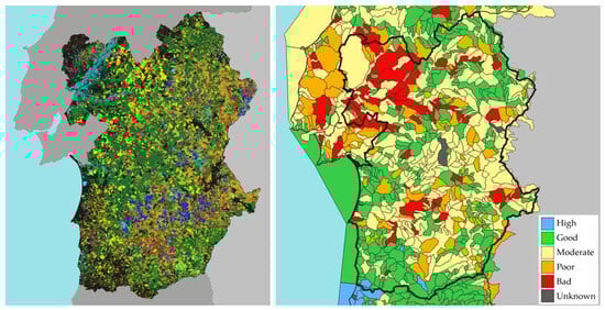
Figure 1.
Farming systems map (left) and micro-basins (right) in the Alentejo region, Portugal. Distinct colours in the FSs map identify different FSs, according to the legend in Table 2 (for details on each FS spatial distribution, refer to supplementary information in [26]). Micro-basins are coloured according to their surface water quality status provided by the river basin management plans and according to the WFD methodology (see legend in figure).
Table 2.
The farming systems of Alentejo, Portugal, in 2017 (adapted from [26]). Figures in round brackets describe the livestock density in livestock units per hectare of total agricultural area. Marks in square brackets describe the expected effect of the FS on water quality: low/null [⊗] or negative [⊖]. Colours provide a legend for Figure 1.
2.3. Farming Systems
The FS typology for the Alentejo region was obtained from Ribeiro et al. [26], based on farm-level data describing land use and livestock patterns in 2017 from the Integrated Administration and Control System (IACS), combined with spatial data from the Land Parcel Identification System (LPIS), provided by the Portuguese agency responsible for CAP payments (details in [26]). A total of 24,313 farms was identified in the study area, covering ca. 2 × 10⁶ ha of UAA (about 87% of total UAA in Alentejo, according to the most recent 2019 agricultural census in Portugal, and 65% of the total Alentejo territorial area). Each farm was characterized based on livestock composition and land-use/crop cover information, described at the parcel and sub-parcel levels, which were spatially explicit via the LPIS. A hierarchical cluster analysis was performed on these data, and a typology of 22 FSs was identified and mapped for the entire region (Table 2, Figure 1).
It is worth highlighting that no information on agricultural practices was used in the construction of the FS typology (e.g., the use of fertilizers, pesticides, machinery, or any other inputs), but only data describing the composition of agricultural land use and livestock, which are those available in the IACS/LPIS database, collected from farmers’ applications for CAP payments. This is a central feature of our approach to investigate whether, in the absence of detailed information on agricultural practices, as in this case, if it is still possible to infer relationships between farmers’ decisions, reflected in the choice of the FS, and their impacts on water quality.
The expected effects of each FS on water quality described in Table 2 were inferred from several characteristics of the FS, such as livestock density, irrigation, forages vs. pastures, or farmland under the cover of oak trees vs. open fields [26].
2.4. Data Analysis
The area share of the different FSs in each micro-basin was computed via GIS analysis, overlaying the FSs and the micro-basin maps (Figure 1). The proportion of pixels identifying each FS in the total number of pixels inside each micro-basin determined the value of the FS share in the micro-basin. This procedure resulted in a two-entry matrix where rows correspond to the micro-basins (the analysis units for the statistical modelling), and columns show the areal share of each FS in the total area of the micro-basin (proportion of FS occupation), along with the classification of the micro-basin in terms of its surface water quality status. All micro-basins with 50% or more of its total area outside the Alentejo region were rejected for the analysis due to lack of agricultural data.
Since not the entire micro-basin area is classified in any FS (as not all micro-basin area is necessarily farmland), a new category was set to identify “unclassified” areas, which were interpreted as largely referring to forested areas (roughly corresponding to the black-coloured areas in the FSs map, Figure 1). We anticipate these forest areas to have positive effects on water quality when compared to FS areas.
To identify which FS contributes most to the water quality status within the micro-basins and accentuate the distinction between the socially Desired (“High” and “Good”) and Undesired (“Moderate”, “Poor”, and “Bad”) quality categories, these were regrouped, converting the dependent multi-categorical variable into a binary variable where “1” was assigned to the Desired group (“High” and “Good”) and “0” to the other Undesired categories. This simplification is in line with point 26 of the preamble of the WFD, which states that “Member States should aim to achieve the objective of at least good water status”. So, a binary logistic model was used to obtain the probability (p) of reaching a “High” or “Good” water quality status in the micro-basin, as follows:
where βi are the logit function coefficients (i = {0, …, n}), and xi (i = {1, …, n}) are the corresponding independent variables describing the areal shares of each FS in the micro-basin, with n = 22 (the number of FS). A negative sign in the β coefficient for a given FS means that when the proportion of this FS increases in the micro-basin area, the probability of obtaining a “High” or “Good” water quality status decreases. The higher the absolute value of the coefficient, the more this is the case.
Since the 22 FS predictors plus the “unclassified” category (mostly forest) make up 100% of the micro-basin area, causing multicollinearity problems as each independent variable is a combination of the others (a common problem with compositional data), it was decided to leave out the “unclassified” (forest) category, thereby serving as the reference category in the models. Thus, a change in the area of any FS will be interpreted as occurring at the expense of the forest, and its effect will be evaluated accordingly. A correlation matrix relating all the remaining independent variables was also computed to check for any further multicollinearity problems. As all candidate independent variables have the same metric and range of values (proportions; from 0 to 1), no normalization procedure was adopted. The pseudo-R2 (Nagelkerke) was computed to evaluate how much of the spatial variability of water quality is explained by the spatial distribution of FS.
3. Results
3.1. Surface Water Quality and Farming System Composition in the Study Area
The Alentejo region encompasses a total of 674 micro-basins. Of these, 70 have more than half the area outside the Alentejo region and were therefore excluded for subsequent analyses, leaving a total of 604 valid micro-basins, all of them referring to inland waters (rivers or reservoirs).
The surface water quality data revealed that 41% of the 604 micro-basins in the Alentejo region achieved a High or Good status in 2017, which were thereby classified under the Desired category. The remaining 59% of the micro-basins did not meet the legally required water quality status and were thus classified in the Undesired category.
Agricultural data showed that in 2017, about 70% of the total area of the 604 micro-basins used in model estimation was classified under one of the 22 FS. The remaining 30% is related to unclassified areas (forest). About 35% of the area was being managed by cattle grazing specialized farming systems, particularly the Cattle grazing–CO (21%) and the Cattle grazing–HO (12%). It should be noted that more than half (ca. 55%) of the area of these micro-basins was being managed by some type of livestock FS.
3.2. Farming Systems Impacts on Surface Water Quality
The correlation matrix for the dependent variables (FS) indicated no relevant correlations (>0.5) between pairs of FSs (only between the Rainfed olive groves FS and the Rainfed olive groves with sheep FS was a value of 0.57 found, which, nevertheless, was not considered sufficient to recommend the removal of one of the variables). The model presented a 0.21 pseudo-R2 (Nagelkerke), revealing that about 21% of the spatial variability of the surface water quality in the Alentejo region can be explained by the FS composition in the micro-basins area. The overall predictive accuracy of the model was 66%, which can be considered an acceptable value since our focus was only to explore how each of the 22 FSs affects the quality of surface waters in the micro-basins rather than seeking to develop a model with high predictive accuracy, which would require also considering other potential drivers of water quality in the micro-basins (e.g., population density, hydrological characteristics of the watersheds, climatic variables).
Among the 22 FS predictor variables included in model estimation, only 7 were revealed to be statistically significant in the model at the 95% confidence level (Table 3). All these significant predictors presented a negative sign, indicating that increasing its proportion in the micro-basin area at the expense of the forest area (the reference category left out in the model to avoid multicollinearity problems) reduces the probability of obtaining a “High” or “Good” surface water quality status. Altogether, these seven FSs cover around 34% of the total area of the Alentejo micro-basins (cf. Table 4). A similar area (35%) was therefore occupied by FSs whose pressure on surface water resources did not show significant differences from that of forest, which occupies the remaining area of the micro-basins (30%).
Table 3.
Estimated coefficients of the binary logistic regression.
Table 4.
Overall forest and farming system areal composition in the 604 micro-basins in the Alentejo region.
The FS showing a negative coefficient with the highest absolute value was the Rice FS, suggesting that it has the greatest impact on water quality, probably due to its typical contiguity with surface water bodies, meaning that any agrochemical application in the crop field can more easily drain to the nearby water stream. The Vineyards FS presented the second highest absolute value of the coefficient, indicating that a high prevalence of this FS in the micro-basin is likely to decrease the quality of surface waters. The Rainfed olive groves with sheep FS presented the third highest value, also revealing that when its area in the micro-basin increases, the probability of obtaining the desired surface water quality status is reduced.
Other FS with statistically significant negative coefficients were Rainfed cereals, Pastures, Cattle grazing–forages, Irrigated olive groves, and Cattle grazing–CO by decreasing the order of the absolute value of their coefficients. It is noteworthy that the seven FS with significant coefficients divide into similar parts between FS specialized in livestock and in crop production, suggesting that there is no obvious difference between the two types of productive orientations in their impacts on surface water quality. Nevertheless, the three FSs with higher coefficient absolute values are all crop-specialized FSs, which, on the other hand, represent a mere 3% of the total area of the micro-basins.
4. Discussion
4.1. Farming Systems and Surface Water Quality
Our results support the hypothesis that, in watersheds dominated by agricultural uses, there is a relationship between the prevalence of specific FSs and the quality of surface water bodies, which is not extensible to all agricultural areas or FS. They also confirm that information on the relative weight of particular FSs in the micro-basin can be used, to a considerable extent, to infer pressures on surface water status. This type of knowledge can be very useful to support the design of innovative and cost-effective land use planning policies aimed at complying with legal water quality standards at the river basin level, such as those under the WFD.
Our findings indicate that only about 1/3 of the FSs in the study area exhibit a significant negative relationship with micro-basin surface water quality. The same is to say that the majority—around 2/3—of the FSs carried out in the region do not seem to pose any threat to the quality of surface water resources.
In our modelling approach, forest areas were taken as the reference land use (left apart in the land use compositional data computed for the micro-basins area to avoid multicollinearity problems). Forest areas can be taken as closer to natural environments since they are areas where fertilizer or pesticide use is virtually absent (exceptions aside) and where the level of disturbance caused by any possible forest management operation is generally much lower than in agricultural areas, as well as because they typically occur at much wider intervals of time than in agriculture. Therefore, the fact that most of the FSs in the study area did not prove significant in the model suggests that their impact on surface water quality is not significantly different from that of forest. This result opposes the widely recognized idea that agriculture is generally more harmful to water quality than forests [27,28,29] by showing that this may only be true for some FSs, which, for this reason, should be prioritized in efforts to reconcile agriculture and water resources management. The interest in this result is particularly notable given the lack of studies focused on comparing the impacts of different agricultural crops on water quality, as most studies consider agriculture as a whole without distinguishing between different crops or activities (or, at most, distinguishing only between cropping and livestock systems).
Although this study does not explain the reasons for the negative relations found between FSs and surface water quality, as the baseline data did not include information on agricultural practices nor on the use of agrochemicals (and this was not the objective of the study), some inference can still be made via comparison with the results of published studies, which also serve to evaluate the validity of our results. The Rice FS proved to be the one that potentially causes the greatest negative impact on surface water quality (coefficient with the highest absolute value). This FS, dominated by rice crops, is subject to intensive cultivation in shallow areas along riverbanks in the Alentejo region, and it has been acknowledged as an environmentally impactful crop, especially related to greenhouse gas emissions, soil degradation, and pollution via the input of fertilizers and pesticides that can be directly washed away to contiguous water streams [30,31,32]. The significant negative impact of the Vineyards FS on surface water quality can be related to the high use of pesticides in these crops, particularly in Mediterranean regions, as reported by previous studies [33,34]. The Rainfed cereals FS presented the third highest (absolute) coefficient, which constitutes an unexpected result since it is typically an extensive FS, with low use of inputs with potential impact on water quality (e.g., fertilizers or pesticides). We can speculate that this may be due to poor agricultural practices, such as the application of fertilizers in a single operation rather than distributed over time, leading to possible leachable surpluses to water courses. Indeed, there is evidence that differences in fertilization can lead to different impacts on water quality [35]. In contrast, the intensive Irrigated olive groves FS, although also revealing a significant negative impact on water quality, the absolute value of the coefficient was much lower, suggesting that the relationship between the level of agricultural intensity and the impact on water quality may not be as straightforward as suggested by many studies [36,37,38,39,40]. In fact, there seems to be evidence that in more intensive agricultural systems, the level of expertise in the use of inputs is also higher, meaning that fertilizers and pesticides are applied to minimize runoff losses [41].
Among the livestock systems that revealed a significant relationship with surface water quality, these included the Cattle grazing–Forages, the Cattle grazing–CO, and the Pastures without trees and livestock FSs (for this later FS, although it is described as an FS without livestock, we have reasons to assume that large parts of these pastures are grazed by animals from neighbouring farmers, under lease [26]). In these FSs, the high stocking rates, some use of fertilizers (especially in Cattle grazing–Forages FS) and vegetation with a very low structure during much of the year due to grazing pressure can lead to soil erosion and runoffs which easily impact surface waters [42]. Interestingly, the Cattle grazing–HO FS did not prove to be significant in this analysis, which may be related to a lower animal density in this FS compared to the other cattle grazing FSs [26]. Equally interesting is the fact that all sheep-grazing FSs also did not prove to be significant in the model. Although the literature comparing the effect of cattle and sheep grazing on water quality is scarce and often presents contrasting results [42,43], there appears to be evidence that nitrate leaching is significantly lower in sheep farming than in cattle systems [44,45,46], which could help explain our results.
Therefore, the fact that our results generally align with those of previous studies on specific crops or activities suggests that our FSs approach, despite not containing information on the use of inputs or agricultural practices, nevertheless contains sufficient information to identify relationships between FSs and water quality and therefore to support policy design, as discussed in the following section.
4.2. Insights for Water Quality Policy in Agricultural Watersheds
A variety of different public policies have been recommended or implemented to address the reconciliation of agriculture and water quality. The polluter pays principle has been a common approach to reducing polluting emissions. However, this option is difficult to apply in the case of non-point pollution, as is typically the case in the agricultural sector [47]. Regulatory approaches have also been proposed to restrict certain agricultural practices, such as the use of pesticides, agrochemicals, and other water pollutants, or to prohibit uncontrolled discharges of environmental contaminants. These approaches, however, usually imply high implementation, control, and inspection costs to ensure compliance, so their practical enforcement remains a challenge. Both the polluter pays principle and the regulatory approach place the burden of pollutant emissions on the polluter’s side, recognizing society’s right to environmental quality.
More recently, approaches based on payments for ecosystem services have been proposed to reward the adoption of good practices and remunerate farmers for their provision of environmental public goods [48]. Under these approaches, the financial burden is placed on the recipients of the ecosystem service. In practice, payments for ecosystem services generally do not pay for the service itself but rather for proxies that provide these services, such as certain land uses [48]. Such policy options have been implemented based on voluntary agreements with farmers who adopt environmentally friendly practices, as under the EU’s Common Agricultural Policy and the European Green Deal [49].
In watersheds where agriculture is the dominant economic activity and land use, the highest pressure on water resources can be expected to come from diffuse pollution from agriculture. Regarding water quality, this study supports the existence of such a relationship by identifying a statistically significant negative association between certain FSs and the quality of surface waters. The finding that agriculture’s impact on water quality is not industry-wide but restricted to certain FSs may constitute valuable information for water management planners, as it allows focusing efforts to preserve water quality in those FSs that effectively put greater pressure on water quality, discouraging its adoption or promoting the improvement in their agricultural practices. For example, water management at the water body level (the micro-basins in this study), as recommended under the EU WFD, may involve preventing certain FSs from assuming an area share above certain size limits in the micro-basin. This is the type of information that can be of great use in supporting the design of the “Programme of Measures” (Article 11 of the WFD) aimed at achieving the objectives established by the WFD, which is mandatory for all Member States.
The choice of the FS is a decision made by farmers, subject to environmental, biophysical, and socioeconomic constraints. Market and policy drivers play a substantial role in this decision-making process [26], so there is room for the implementation of public policies encouraging farmers’ decisions towards more environmentally friendly FSs, such as agri-environmental payments, a policy-design approach that has been suggested by previous studies [17,47,50].
4.3. Shortcomings of the Approach and Directions for Future Research
Although the results suggest that our methodological approach was adequate for the study objectives, some options could be revised in the future to increase the generalization of the framework to other biophysical and socioeconomic contexts. For example, it is possible that the large variability in the size of the micro-basins in the study area made it difficult to capture clearer FS-water quality relationships, as larger watersheds can exhibit greater landscape heterogeneity (both in composition and configuration), making it more difficult to link FSs and water quality. A pre-selection of micro-basins with an area not exceeding a certain size threshold could be tested to minimize this possible effect.
Additionally, the average distance of each FS in the micro-basin to the water sampling points could have influenced the results since agricultural areas closer to the sampling point may, under other circumstances, have greater influence on the water quality parameters as compared to those located further upstream.
Future research could also investigate what the maximum weight of certain FSs negatively associated with water quality in the agricultural watershed area could be without compromising the WFD objective of achieving Good or High surface water quality status. This would provide an easy-to-monitor indicator of water quality status at the river basin scale.
The proposed approach requires classifying farms according to the FS in an expeditious, efficient, and easily updatable way. In the EU, this can be accomplished by resorting to data such as that annually collected via farmers’ applications for CAP payments (IACS/LPIS data), but this may be a limitation for the generalization of the methodology outside the EU, where this type of spatially explicit farm-level data may not be as easily available.
5. Conclusions
This study is an implementation of an FSs approach presented by Santos et al. [17] to link agricultural policies with biodiversity and ecosystem services, already tested and established in several previous studies [21,22,23,25]. In this study, we adjusted the approach to assess its feasibility and usefulness in supporting water quality management policies in areas where agriculture is the main economic activity and the main source of pressure on water resources. The analysis was developed under the scope and objectives of the EU Water Framework Directive (WFD), which is the main instrument of European water policy.
With this approach, we developed a framework that takes advantage of two readily accessible databases available across the EU, one with agricultural data from IACS/LPIS and the other with water quality data from the WISE/WFD, to relate the agricultural management decisions of hundreds or thousands of farmers located in a given river basin, implicit in the choice of the FS by each farmer, with data on the water quality status of each micro-basin, classified on a 5-level qualitative scale (from “bad” to “ high”), as part of the preparation of WFD river basin plans.
The underlying assumption was that if it is possible to establish that agricultural pressures on water quality derive mainly from certain, identifiable FSs in the micro-basin and not others then this information can be enough to design water management policies discouraging farmers from adopting these FSs in favour of others less harmful to the water environment, without the need for any further detailed (costly) information required to explain the exact processes causing pressure on water quality.
To our knowledge, this framework is the first attempt to directly link farmers’ management decisions with surface water quality designed for the level of territorial management units, such as the river basin, which are large enough to justify the design and implementation of tailored agri-environmental policies. Furthermore, it has the potential to be a relatively simple, low-cost, and effective approach to delivering water quality improvements based on ready-to-use and regularly updated data, which avoids the practical unfeasibility of controlling and monitoring compliance with regulations on the use of inputs or agricultural practices potentially harmful to water quality, across a large number of farmers.
We therefore argue that the results achieved suggest the effective practical utility of the proposed framework, as they confirmed our initial hypotheses about the relationships between different FSs and water quality, indicating that it may be a potentially cost-effective approach to support the design of water quality management policies in agricultural watersheds.
Author Contributions
Conceptualization, P.F.R. and J.L.S.; methodology, P.F.R., F.N.D. and J.L.S.; data curation: P.F.R. and F.N.D.; validation, P.F.R., F.N.D. and J.L.S.; formal analysis, P.F.R. and F.N.D.; writing—original draft preparation, F.N.D. and P.F.R.; writing—review and editing, F.N.D., P.F.R. and J.L.S.; project administration, P.F.R., F.N.D. and J.L.S. All authors have read and agreed to the published version of the manuscript.
Funding
This work was financed by national funds via FCT—Portuguese Foundation for Science and Technology, I.P., under Project UIDB/00239/2020 of the Forest Research Centre (CEF) and the Associate Laboratory TERRA.
Data Availability Statement
The data presented in this study are openly available in https://water.europa.eu and in https://snig.dgterritorio.gov.pt.
Conflicts of Interest
The authors declare no conflicts of interest.
References
- Grizzetti, B.; Lanzanova, D.; Liquete, C.; Reynaud, A.; Cardoso, A.C. Assessing water ecosystem services for water resource management. Environ. Sci. Policy 2016, 61, 194–203. [Google Scholar] [CrossRef]
- Sachs, J.D.; Lafortune, G.; Fuller, G.; Drumm, E. Implementing the SDG Stimulus. Sustainable Development Report 2023; Dublin University Press: Dublin, Ireland, 2023. [Google Scholar] [CrossRef]
- Boretti, A.; Rosa, L. Reassessing the projections of the World Water Development Report. NPJ Clean Water 2019, 2, 15. [Google Scholar] [CrossRef]
- FAO. Water for Sustainable Food and Agriculture, A report produced for the G20 Presidency of Germany; Food and Agriculture Organization of the United Nations: Rome, Italy, 2017. [Google Scholar]
- Tomaz, A.; Palma, P.; Fialho, S.; Lima, A.; Alvarenga, P.; Potes, M.; Salgado, R. Spatial and temporal dynamics of irrigation water quality under drought conditions in a large reservoir in Southern Portugal. Environ. Monit. Assess. 2020, 192, 93. [Google Scholar] [CrossRef]
- Alexandratos, N.; Bruinsma, J. World Agriculture towards 2030/2050 the 2012 Revision. 2012. Available online: www.fao.org/economic/esa (accessed on 12 January 2023).
- Dodds, W.K.; Perkin, J.S.; Gerken, J.E. Human impact on freshwater ecosystem services: A global perspective. Environ. Sci. Technol. 2013, 47, 9061–9068. [Google Scholar] [CrossRef]
- WWDR. The United Nations World Water Development Report 2018: Nature-Based Solutions for Water; United Nations Educational, Scientific and Cultural Organization: Paris, France, 2018; Available online: www.unwater.org/publications/%0Aworld-water-development-report-2018/ (accessed on 25 October 2023).
- Stinner, J.H. Effects of Agroecosystem Management on Water Quality in Multiple Watersheds in Ohio; The Ohio State University: Columbus, OH, USA, 2016. [Google Scholar]
- D’amario, S.C.; Rearick, D.C.; Fasching, C.; Kembel, S.W.; Porter-Goff, E.; Spooner, D.E.; Williams, C.J.; Wilson, H.F.; Xenopoulos, M.A. The prevalence of nonlinearity and detection of ecological breakpoints across a land use gradient in streams. Sci. Rep. 2019, 9, 3878. [Google Scholar] [CrossRef] [PubMed]
- DeFries, R.S.; Foley, J.A.; Asner, G.P. Land-use choices: Balancing human needs and ecosystem function. Front. Ecol. Environ. 2004, 2, 249–257. [Google Scholar] [CrossRef]
- Maes, W.H.; Heuvelmans, G.; Muys, B. Assessment of land use impact on water-related ecosystem services capturing the integrated terrestrial−aquatic system. Environ. Sci. Technol. 2009, 43, 7324–7330. [Google Scholar] [CrossRef]
- Bernués, A.; Tello-García, E.; Rodríguez-Ortega, T.; Ripoll-Bosch, R.; Casasús, I. Agricultural practices, ecosystem services and sustainability in High Nature Value farmland: Unraveling the perceptions of farmers and nonfarmers. Land Use Policy 2016, 59, 130–142. [Google Scholar] [CrossRef]
- Dale, V.H.; Polasky, S. Measures of the effects of agricultural practices on ecosystem services. Ecol. Econ. 2007, 64, 286–296. [Google Scholar] [CrossRef]
- Valente, R.A.; de Mello, K.; Metedieri, J.F.; Américo, C. A multicriteria evaluation approach to set forest restoration priorities based on water ecosystem services. J. Environ. Manag. 2021, 285, 112049. [Google Scholar] [CrossRef]
- Zhong, L.; Wang, J.; Zhang, X.; Ying, L. Effects of agricultural land consolidation on ecosystem services: Trade-offs and synergies. J. Clean. Prod. 2020, 264, 121412. [Google Scholar] [CrossRef]
- Santos, J.L.; Moreira, F.; Ribeiro, P.F.; Canadas, M.J.; Novais, A.; Lomba, A. A farming systems approach to linking agricultural policies with biodiversity and ecosystem services. Front. Ecol. Environ. 2020, 19, 168–175. [Google Scholar] [CrossRef]
- Darnhofer, I.; Gibbon, D.; Dedieu, B. Farming systems research: An approach to inquiry. In Farming Systems Research into the 21st Century: The New Dynamic; Springer: Dordrecht, The Netherlands, 2012; pp. 3–31. [Google Scholar] [CrossRef]
- Dixon, J.; Gulliver, A.; Gibbon, D. Farming Systems and Poverty—Improving Farmers’ Livelihoods in a Changing World; FAO: Rome, Italy; World Bank: Washington, DC, USA, 2001. [Google Scholar]
- Ferraton, N.; Touzard, I. Comprendre l’Agriculture Familiale. Diagnostic des Systèmes de Production; Edition Quae, CTA, Presse Agronomique de Gembloux: Gembloux, Belgium, 2009. [Google Scholar]
- Ribeiro, P.F.; Santos, J.L.; Santana, J.; Reino, L.; Beja, P.; Moreira, F. An applied farming systems approach to infer conservation-relevant agricultural practices for agri-environment policy design. Land Use Policy 2016, 58, 165–172. [Google Scholar] [CrossRef]
- Ribeiro, P.F.; Nunes, L.C.; Beja, P.; Reino, L.; Santana, J.; Moreira, F.; Santos, J.L. A Spatially Explicit Choice Model to Assess the Impact of Conservation Policy on High Nature Value Farming Systems. Ecol. Econ. 2018, 145, 331–338. [Google Scholar] [CrossRef]
- Ribeiro, P.F.; Santos, J.L.; Santana, J.; Reino, L.; Leitão, P.J.; Beja, P.; Moreira, F. Landscape makers and landscape takers: Links between farming systems and landscape patterns along an intensification gradient. Landsc. Ecol. 2016, 31, 791–803. [Google Scholar] [CrossRef]
- Silva, J.; Santos, J.; Ribeiro, P.; Canadas, M.; Novais, A.; Lomba, A.; Magalhães, M.; Moreira, F. Identifying and explaining the farming system composition of agricultural landscapes: The role of socioeconomic drivers under strong biophysical gradients. Landsc. Urban Plan. 2020, 202, 103879. [Google Scholar] [CrossRef]
- Silva, J.; Santos, J.; Ribeiro, P.; Marta-Pedroso, C.; Magalhães, M.; Moreira, F. A farming systems approach to assess synergies and trade-offs among ecosystem services. Ecosyst. Serv. 2024, 65, 101591. [Google Scholar] [CrossRef]
- Ribeiro, P.F.; Santos, J.L.; Canadas, M.J.; Novais, A.M.; Moreira, F.; Lomba, A. Explaining farming systems spatial patterns: A farm-level choice model based on socioeconomic and biophysical drivers. Agric. Syst. 2021, 191, 103140. [Google Scholar] [CrossRef]
- de Mello, K.; Valente, R.A.; Randhir, T.O.; Vettorazzi, C.A. Impacts of tropical forest cover on water quality in agricultural watersheds in southeastern Brazil. Ecol. Indic. 2018, 93, 1293–1301. [Google Scholar] [CrossRef]
- Clément, F.; Ruiz, J.; Rodríguez, M.A.; Blais, D.; Campeau, S. Landscape diversity and forest edge density regulate stream water quality in agricultural catchments. Ecol. Indic. 2017, 72, 627–639. [Google Scholar] [CrossRef]
- Kim, G.; Chung, S.; Lee, C. Water quality of runoff from agricultural-forestry watersheds in the Geum River Basin, Korea. Environ. Monit. Assess. 2007, 134, 441–452. [Google Scholar] [CrossRef]
- Kimaro, J. A Review on Managing Agroecosystems for Improved Water Use Efficiency in the Face of Changing Climate in Tanzania. Adv. Meteorol. 2019, 2019, 9178136. [Google Scholar] [CrossRef]
- de Miranda, M.S.; Fonseca, M.L.; Lima, A.; de Moraes, T.F.; Rodrigues, F.A. Environmental Impacts of Rice Cultivation. Am. J. Plant Sci. 2015, 6, 2009–2018. [Google Scholar] [CrossRef]
- You, L.; Spoor, M.; Ulimwengu, J.; Zhang, S. Land use change and environmental stress of wheat, rice and corn production in China. China Econ. Rev. 2011, 22, 461–473. [Google Scholar] [CrossRef]
- Hildebrandt, A.; Guillamón, M.; Lacorte, S.; Tauler, R.; Barceló, D. Impact of pesticides used in agriculture and vineyards to surface and groundwater quality (North Spain). Water Res. 2008, 42, 3315–3326. [Google Scholar] [CrossRef]
- Serpa, D.; Nunes, J.; Keizer, J.; Abrantes, N. Impacts of climate and land use changes on the water quality of a small Mediterranean catchment with intensive viticulture. Environ. Pollut. 2017, 224, 454–465. [Google Scholar] [CrossRef]
- Löw, P.; Osterburg, B.; Klages, S. Comparison of regulatory approaches for determining application limits for nitrogen fertilizer use in Germany. Environ. Res. Lett. 2021, 16, 055009. [Google Scholar] [CrossRef]
- Ilampooranan, I.; Van Meter, K.J.; Basu, N.B. Intensive agriculture, nitrogen legacies, and water quality: Intersections and implications. Environ. Res. Lett. 2022, 17, 035006. [Google Scholar] [CrossRef]
- Garcia, A. The Environmental Impacts of Agricultural Intensification; CGIAR Advisory Services—Standing Panel on Impact Assessment: Fiumicino, Italy, 2020; Available online: https://cas.cgiar.org/spia (accessed on 26 October 2023).
- Tang, W.; Ao, L.; Zhang, H.; Shan, B. Accumulation and risk of heavy metals in relation to agricultural intensification in the river sediments of agricultural regions. Environ. Earth Sci. 2014, 71, 3945–3951. [Google Scholar] [CrossRef]
- Lange, K.; Townsend, C.R.; Gabrielsson, R.; Chanut, P.C.M.; Matthaei, C.D. Responses of stream fish populations to farming intensity and water abstraction in an agricultural catchment. Freshw. Biol. 2014, 59, 286–299. [Google Scholar] [CrossRef]
- Zahoor, I.; Mushtaq, A. Water Pollution from Agricultural Activities: A Critical Global Review. Int. J. Chem. Biochem. Sci. 2023, 23, 164–176. [Google Scholar]
- Gaffneya, J.; Binga, J.; Byrne, P.F.; Cassman, K.G.; Ciampitti, I.; Delmer, D.; Habben, J.; Lafitte, H.R.; Lidstrom, U.E.; Porter, D.O.; et al. Science-based intensive agriculture: Sustainability, food security, and the role of technology. Glob. Food Secur. 2019, 23, 236–244. [Google Scholar] [CrossRef]
- Carmen, T.A.; Stephen, R.W.; Richard, C.W.; Gregory, D.J. Livestock grazing management impacts on stream water quality: A review. JAWRA J. Am. Water Resour. Assoc. 2005, 41, 591–606. [Google Scholar] [CrossRef]
- Cournane, F.C.; McDowell, R.; Littlejohn, R.; Condron, L. Effects of cattle, sheep and deer grazing on soil physical quality and losses of phosphorus and suspended sediment losses in surface runoff. Agric. Ecosyst. Environ. 2011, 140, 264–272. [Google Scholar] [CrossRef]
- Williams, P.H.; Haynes, R.J. Comparison of initial wetting pattern, nutrient concentrations in soil solution and the fate of15N-labelled urine in sheep and cattle urine patch areas of pasture soil. Plant Soil 1994, 162, 49–59. [Google Scholar] [CrossRef]
- Maheswaran, S.; Cranston, L.M.; Millner, J.P.; Horne, D.J.; Hanly, J.A.; Kenyon, P.R.; Kemp, P.D. Effects of Sheep Grazing Systems on Water Quality with a Focus on Nitrate Leaching. Agriculture 2022, 12, 758. [Google Scholar] [CrossRef]
- Hoogendoorn, C.J.; Betteridge, K.; Ledgard, S.F.; Costall, D.A.; Park, Z.A.; Theobald, P.W. Nitrogen leaching from sheep-, cattle- and deer-grazed pastures in the Lake Taupo catchment in New Zealand. Anim. Prod. Sci. 2011, 51, 416–425. [Google Scholar] [CrossRef]
- Mateo-Sagasta, J.; Zadeh, S.M.; Turral, H. Water Pollution from Agriculture: A Global Review; Food and Agriculture Organization of the United Nations: Rome, Italy; International Water Management Institute on behalf of the Water Land and Ecosystems Research Program: Colombo, Sri Lanka, 2017; Available online: http://www.fao.org/3/a-i7754e.pdf (accessed on 3 April 2022).
- Mauerhofer, V.; Hubacek, K.; Coleby, A.; Mauerhofer, V.; Hubacek, K.; Coleby, A. From Polluter Pays to Provider Gets: Distribution of Rights and Costs under Payments for Ecosystem Services. Ecol. Soc. 2013, 18, 14. [Google Scholar] [CrossRef]
- Cuadros-casanova, I.; Sessa, A.A.; Pacifici, M.; Cimatti, M.; Biancolini, D.; Cristiano, A.; Yeraldin, V.; Angarita, M.; Dragonetti, C.; Di Marco, M.; et al. Opportunities and challenges for Common Agricultural Policy reform to support the European Green Deal. Conserv. Biol. 2023, 37, e14052. [Google Scholar] [CrossRef] [PubMed]
- Holden, J.; Haygarth, P.; MacDonald, J.; Jenkins, A.; Spaiets, A.; Orr, H.; Dunn, N.; Harris, B.; Pearson, P.; McGonigle, D.; et al. Agriculture’s Impacts on Water Quality; Global Food Security; Sub Report—Farming and Water 1; The UK Water Partnership: London, UK, 2015. [Google Scholar]
Disclaimer/Publisher’s Note: The statements, opinions and data contained in all publications are solely those of the individual author(s) and contributor(s) and not of MDPI and/or the editor(s). MDPI and/or the editor(s) disclaim responsibility for any injury to people or property resulting from any ideas, methods, instructions or products referred to in the content. |
© 2024 by the authors. Licensee MDPI, Basel, Switzerland. This article is an open access article distributed under the terms and conditions of the Creative Commons Attribution (CC BY) license (https://creativecommons.org/licenses/by/4.0/).