Article

Spatial Variation in Soil Physico-Chemical Properties along Slope Position in a Small Agricultural Watershed Scale

1
College of Natural Resources and Environment, Northwest A&F University, Xianyang 712100, China
2
State Key Laboratory of Soil Erosion and Dryland Farming on the Loess Plateau, Northwest A&F University, Xianyang 712100, China
3
College of Water Conservancy & Architectural Engineering, Shihezi University, Shihezi 832000, China
4
University of Chinese Academy of Sciences, Beijing 100039, China
5
School of Geographical Sciences, Nanjing University of Information Science and Technology, Nanjing 210044, China
*
Author to whom correspondence should be addressed.
Agronomy 2022, 12(10), 2457; https://doi.org/10.3390/agronomy12102457
Submission received: 2 August 2022 / Revised: 20 September 2022 / Accepted: 30 September 2022 / Published: 10 October 2022

Abstract

:
Both cropland management and slop erosion are important factors influencing soil properties, but there are relatively few studies on their combined effects. Studies at the agricultural watershed scale can satisfy both of these conditions, and to reduce the effects of soil heterogeneity due to differences in spatial scale, it is better to select different slopes in the same small watershed. To understand how soil properties will respond to the variation of slope position and cropland management at an agricultural watershed, we present the distribution of soil bulk density (BD), saturated hydraulic conductivity (Ks), water-stable aggregates, soil organic carbon (OC), nitrogen (N), and phosphorus (P) at four slope positions in two cropland management systems of a small agricultural watershed in the black soil region of northeast China. The selected four slope positions include upper slope, middle slope, lower slope, and footslope positions. The two cropland management systems consist of a sustainable cropland system (i.e., contour ridge tillage at upper slope position, longitudinal ridge tillage at middle slope and lower slope positions, and grassland at footslope position) and a conventional cropland system (i.e., contour ridge tillage at upper slope position, longitudinal ridge tillage at middle slope, lower slope positions, and footslope positions). The results showed that soil bulk density and microaggregates decreased but the concentration of OC and nutrients, Ks, and small-macroaggregate increased from the upper slope position to the lower slope position in both the conventional and sustainable croplands, which was due to the interaction effect of cultivation with erosion. In comparison with conventional cropland, sustainable cropland has greater Ks, large-macroaggregate, small-macroaggregate, microaggregate, and concentrations and stocks of OC, N, and P, but showed lower bulk density and silt + clay fraction. However, the prominent differences in both croplands were presented in the footslope position, which is ascribed to the interaction of cultivation, erosion, and cropland management. These results highlighted that sustainable cropland management practice has the potential to improve soil structure and prevent soil and nutrient loss.

1. Introduction

The black soil region of northeast China is characterized by gentle topography, fertile soil, and a larger soil organic carbon (OC) pool and has long been deemed as an important cereal production base [1]. However, this region suffers from severe soil erosion (tillage erosion, wind erosion, water erosion, and freeze-thaw erosion) and over-cultivation that lead to soil degradation and a reduction in ecosystem productivity and sustainability [1,2,3]. Soil erosion and over-cultivation could cause the loss of soil OC and nutrients and any decrease of soil OC and nutrients in this region could result in higher greenhouse gas emissions which influence global climate change [4,5].
Current studies regarding the effects of cultivation on soil properties have mainly focused on the field scale [6,7], while the response of soil properties as affected by cultivation and erosion to the agricultural watershed scale has been less investigated. In an agriculturally developed region with gentle terrain, mechanical farming, which plays an essential role in regulating crop growth at the agricultural watershed scale, often loosens surface soil but forms plough pan and compacts deep soil. Moreover, water erosion, wind erosion, and tillage erosion occur with the topography of the watershed, and hence result in the transportation of soil particles and variations in soil properties at the agricultural watershed scale [8,9]. However, the knowledge gap of distribution of soil properties at different slope positions of the agricultural watershed scale hinders our ability to specifically understand soil degradation for long-term cultivation as well as the erosion process at the agricultural watershed.
Cultivation results in the variation of soil physical and chemical properties with spatial-temporal changes, i.e., the depletion of soil physical properties, the transportation of soil organic matter and nutrients from in situ, and emissions of carbon and nitrogen (N) into the atmosphere. Such variations in turn deteriorate the soil resulting from soil crusting, compaction, loss of nutrients, and a decrease in soil microbial activity and diversity [10,11]. The effective cropland management approach (i.e., human-induced land-use changes and conversation tillage) has been widely accepted as protecting soils from degradation [12,13]. Sustainable human-induced land-use changes and conservation tillage increase soil organic carbon and nutrient pools, aggregate stability, and enzyme activity, but decrease soil bulk density (BD), and therefore, improve soil physical and chemical properties and contribute to the increase of the agricultural ecosystem productivity [13,14]. However, the effects of sustainable land-use change and conversation tillage on soil properties varies with their types [15,16]. Therefore, a better understanding of the response of the soil physical and chemical properties in cropland management would help to understand the mechanism underlying the restoration of the degraded agricultural ecosystem and would give effective suggestions on land use management to policy makers.
The intensity of soil erosion and the output of sediment in sloping land were supposed to be related to land-use change and the aspect and gradient of the slope that directly affects the mass of the above- and under-ground biomass [17,18], while the responses of soil erosion to slope angle in sloping land were hypothesized to be increased with the increase of the slope [19,20]. For example, Lin et al. [21] observed that sediment transport capacity depended on the slope gradient and overland flow rate, and while the gravel-sized particles increased, the silt and clay fractions decreased with increasing flow rate and slope gradient. Tuo et al. [22] found that the total soil erosions were higher but the 137Cs inventories were lower on the northwest-facing slopes, and therefore, soil OC, total N, clay, and silt contents were lower on northwest-facing slopes than those on southeast-facing slopes. Furthermore, slope and aspect significantly influence the variation of soil physical properties and the redistribution and transportation distance of soil organic carbon and nutrients, as well as the intensity of their responses to tillage and erosion [23,24]. However, the distribution patterns of soil properties and their responses to slope and aspect in sloping land have not been examined in the black soil region of Northeast China.
In summary, there is a paucity of knowledge on the distribution of soil properties at different slope positions within the agricultural watershed, and in particular a lack of research on the response characteristics of sustainable farming practices. While the use of small watersheds as a unit to control soil and water conservation is one of the main ways to restore the fertility of sloping agricultural land in the black soil region of Northeast China, there is a lack of research on the distribution patterns of soil properties and their responses to variation of slope position and cropland management. Thus, research is urgently needed given the important roles of the distribution of soil physical and chemical properties at an agricultural watershed in mediating the sustainability of black soils.
Based on the above considerations, we generated the following hypotheses: (H1) sustainable cropland management would improve soil physical environment and increase OC and nutrient levels compared with conventional cropland management at a small agricultural watershed scale; (H2) soil physical properties, OC and nutrients could be improved from the upper slope position to the lower slope position, and the effects of the lower slope and footslope positions on improving soil physical properties, OC, and nutrients would be greater than other positions under sustainable and conventional cropland management. To test these hypotheses, we present the results of the soil physical properties (i.e., soil BD, aggregates and Ks), OC, N, and phosphorus (P) at the upper slope, middle slope, lower slope, and footslope positions and different soil depths (i.e., 0–15, 15–30, 30–50, 50–70, and 70–100 cm) under the conventional and sustainable cropland management systems at a small agricultural watershed.

2. Materials and Methods

2.1. Study Area

We conducted this study in a small agricultural watershed of Heshan farm (48°59′–49°03′ N, 125°16′–125°21′ E) of Heilongjiang Province in Northeast China (Figure 1). According to the description by Li et al. [25], the topography in the study area is characterized by long (up to 800–2000 m) but gentle (1–4°) slopes with elevations of 310–390 m asl. The region has a cold and semiarid climate, the mean annual temperature is approximately 0.4 °C, the mean annual precipitation is 500 mm, of which 66.6% falls between June and August. The average frost-free period is 115–120 days. The soil in the selected small watershed is black soil, which is Mollisols according to USDA soil taxonomy [26].

2.2. Field Investigation and Soil Sampling

This study region consists of two typical cropland management systems (i.e., conventional cropland management system and sustainable cropland management system) along two main branches at an agricultural watershed. The watershed has a main channel length of 1.6 km and an area of 0.27 km2, and the two main branches have an area of 3.32 km2. The soil and water loss from this study watershed have been monitored by scientists from Beijing Normal University for nearly 20 years (since the early 2000s) [27,28,29]. According to the results of previous studies, there was serious water erosion on the slope and deposition at the footslope position. The conventional cropland and sustainable cropland are located at north-facing slopes and south-facing slopes according to the trends of the two main branches, respectively. The conventional cropland systems were composed of cross (contour) ridge tillage at the upper slope position and longitudinal ridge tillage at the middle slope, lower slope, and footslope positions. The sustainable cropland systems were composed of cross (contour) ridge tillage at the upper slope position, longitudinal ridge tillage at the middle slope and lower slope positions, and grassland at the footslope position. The cropland was converted from forest approximately 60 years ago, crops in the two cropland systems have varied over the years but are mainly maize (Zea mays L.) and soybean (Glycine max (Linn.) Merr.), and annual tillage management has kept the slope flat.
In the harvest season of 2017 (early October), we established 4 transects (i.e., upper slope position, middle slope position, lower slope position, and footslope position) in the two cropland managements of a small agricultural watershed according to the contour and terrain, respectively (Figure 1). The distances of adjacent slope positions from upper slope position to footslope position were equivalent. We assumed that any changes in soils were due to agricultural cultivation and erosion. We conducted 5 sampling plots (10 × 10 m) in each transect for collecting soil samples. According to the depth of black soil (50–70 cm) and the tillage depth (30–50 cm) [25], the soils below this depth could be affected by the mechanical pressure and roots, so we collected soil from 0–100 cm depth to investigate the effects of cropland management and slope position in this study. In each sampling plot, a 1.0 × 1.0 × 1.0 m pit was dug to collect undisturbed soil cores from depths of 0–15, 15–30, 30–50, 50–70, and 70–100 cm. To ensure that the soil samples were not damaged, we collected the soil cores with 100 cm−3 stainless steel cylinders (5.05 cm diameter and 5.0 cm height) at a suitable soil moisture level, and the soil moisture was determined to be 18.8–26.8%. Five disturbed soil samples were collected with a 5.0 cm diameter soil auger from each depth of 0–15, 15–30, 30–50, 50–70, and 70–100 cm in each sampling plot, respectively, and combined to form a composition sample for each depth.

2.3. Measurement of Soil Properties

The composite soil samples were transported to the laboratory and air-dried. The air-dried composition samples were ground to pass through 8.0 mm, 2.0 mm, and 0.25 mm sieves to analyze the water-stable aggregates, particle composition, and the contents of OC, N, and P, respectively. Soil particle composition was measured using laser diffraction methods (Mastersizer 2000, Malvern Instruments, Malvern, UK). The OC contents were determined using the oil bath-K2Cr2O7 titration method of Walkley–Black [30]. Total N contents were measured using the Kjeldahl method [31]. Total P content was determined colorimetrically after wet digestion with sulfuric acid and perchloric acid [32]. A 200-g air-dried soil sample (<8.0 mm) was analyzed for water-stable aggregate distribution by an adopted wet sieving method [33]. The four aggregate classes, i.e., large macroaggregate (LMA, >2 mm), small macroaggregate (SMA, 0.25–2 mm), microaggregate (MI, 0.25–0.053 mm), and silt + clay fraction (SC, <0.053 mm), were separated. These measurement procedures for water-stable aggregate were described in detail by Li et al. [25] Although the method might overestimate the proportion of small size aggregates due to the excessive disturbance of this fraction, we reported results from this most commonly used method so that our results would be comparable with others [25,33].
The first sub-samples of undisturbed soil cores were transported to the laboratory and linked to Mariotte’s bottle to measure saturated hydraulic conductivity (Ks, cm d−1) using the constant-head method based on Darcy’s law [34]. The soil bulk density was determined by oven-drying at 105 °C for 24 h followed by gravimetric measurement from the same soil core samples after the measurement of Ks [35].
Stocks (kg m−2) of soil OC, N, and P were calculated as follows:
Stocks   of   O C i = D i × B D i × O C i 100
Stocks   of   N i = D i × B D i × N i 100
Stocks   of   P i = D i × B D i × P i 100
where Di, BDi, OCi, Ni, and Pi represent the thickness (cm), bulk density (g cm−3), and contents of OC (g kg−1), N (g kg−1), and P (g kg−1), respectively, of the ith layer of soil.

2.4. Statistical Analysis

Two-way analysis of variance and correlation analyses were conducted using SPSS 13.0 software. Two-way analysis of variance was used to test the slope position and soil depth main effects and interaction effects on soil BD, Ks, aggregates, OC, N, and P (p < 0.05). Correlation analysis was used to evaluate the relationships among the soil variables. Testing of significant differences was performed using the Duncan s test.

3. Results

3.1. Effect of Slope Position and Cropland Management on Bulk Density and Saturated Hydraulic Conductivity

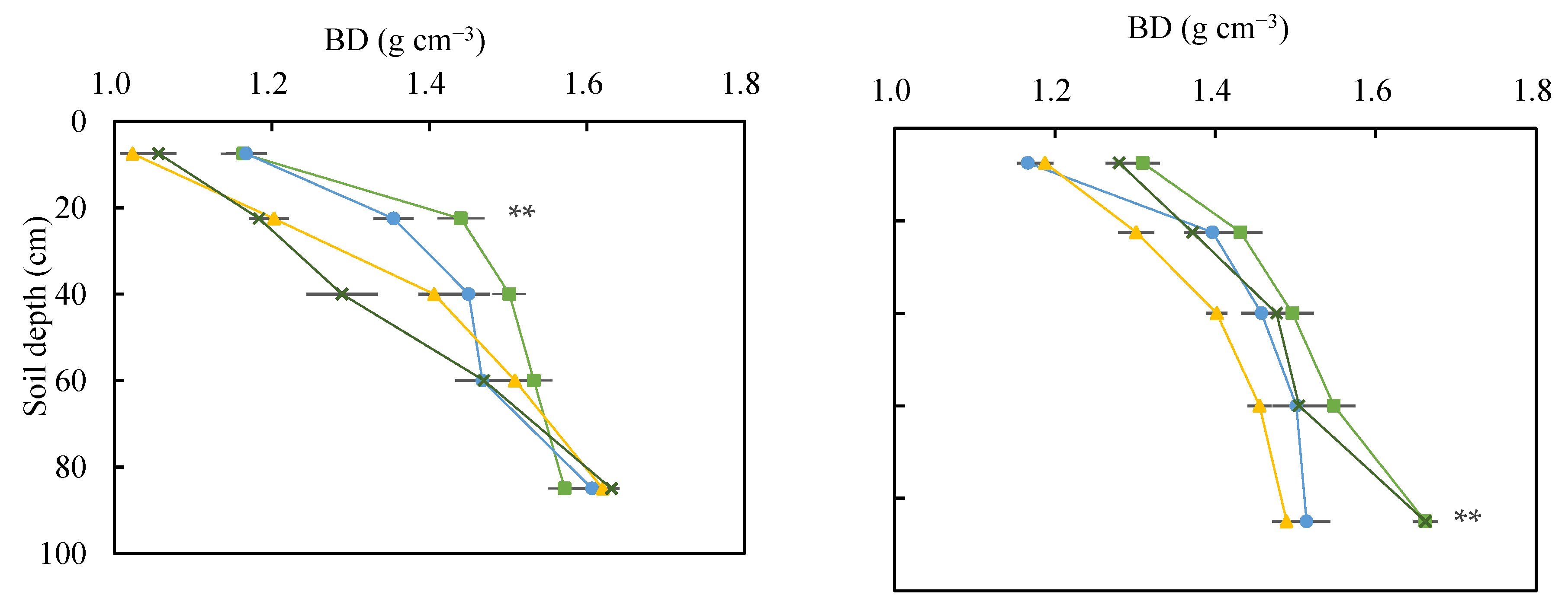
The effects of slope position on soil bulk density and Ks differed with cropland managements (Figure 2). In both conventional and sustainable croplands, soil bulk density decreased but Ks increased from the upper slope to the lower slope position. However, in sustainable cropland, soil bulk density was lowest and Ks was highest at the footslope position. In conventional cropland, soil bulk density was lower at the footslope position than that at the upper slope position while higher than those at the middle slope and lower slope positions. However, Ks was greater at the footslope position than that at the upper slope position while lower than those at the middle slope and lower slope positions (Figure 2). When averaged across the slope positions, soil bulk density increased 0.13 g cm−3 (p = 0.002) and Ks decreased 15.85 cm d−1 (p = 0.01) in conventional cropland compared with sustainable cropland at 0–15 cm depth. With increasing soil depth in both conventional cropland and sustainable cropland, soil bulk density significantly increased, and the increase was recorded along the soil profiles (0–100 cm), but Ks decreased and the decrease mainly occurred at 0–50 cm depth (Figure 2).

3.2. Effect of Slope Position and Cropland Management on Water-Stable Aggregates

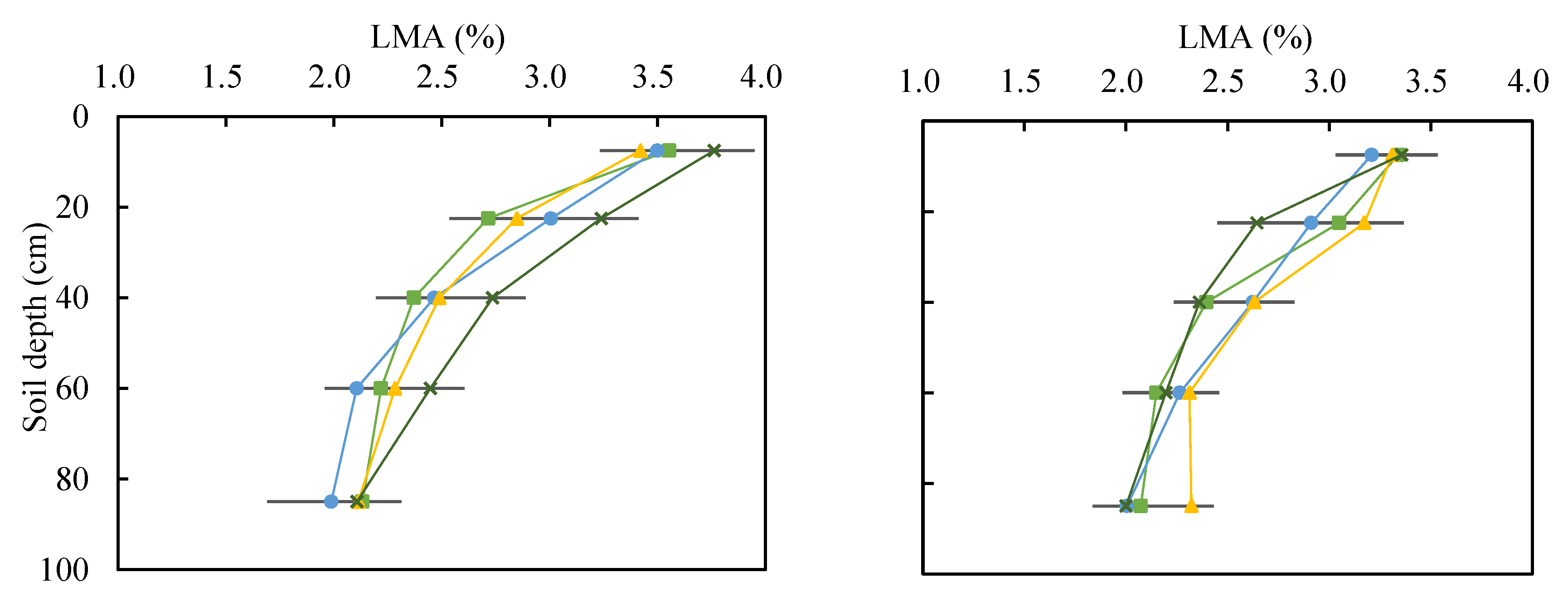
Averaged across all sources of variation, small macroaggregate (0.25–2 mm) dominated the soil mass in the study region, with a proportion of 66% (62–69%), while large macroaggregate (>2 mm), microaggregate (0.053–2 mm), and silt + clay fraction (<0.053 mm) accounted for 3% (2–4%), 19% (16–21%), and 12% (9–16%) of the soil mass, respectively. The proportion of small macroaggregate significantly increased from the upper slope position to the lower slope position and footslope position in the two cropland management systems. Furthermore, the proportion of small macroaggregate was highest at the footslope position in sustainable cropland and lower slope position in the conventional cropland, respectively (Figure 3). The proportion of microaggregate decreased from the upper slope position to the lower slope position in the two cropland systems (Figure 3). Moreover, microaggregate at the footslope position was lower than the upper slope position but was greater than those at the middle slope and lower slope positions in the sustainable cropland, while microaggregate at the footslope position was lower than the upper slope position but was greater than that only at the lower slope position in the conventional cropland (Figure 3). However, the effects of the slope position and cropland managements on large macroaggregate and silt + clay fraction were weak (Figure 3 and Table 1). In addition, the proportion of large macroaggregate, small macroaggregate, and microaggregate averaged for all slope positions were higher but the silt + clay fraction was lower in the sustainable cropland than in the conventional cropland (2.68% in LMA, 66.11% in SMA, 19.38% in MI, 11.75% in SC vs. 2.62%, 65.87%, 19.15%, 12.36%, respectively) (Figure 3). However, the difference between the conventional cropland and sustainable cropland was not statistically significant.
The response of aggregates distribution to soil depth varied with aggregates sizes in the two cropland management systems (Figure 3 and Table 1). The proportions of large macroaggregate and silt + clay fraction decreased but the proportions of small macroaggregate and microaggregate increased with soil depth in 0–30 cm soils. However, the proportions of large macroaggregate and small macroaggregate decreased but the proportions of microaggregate and silt + clay fraction increased within the soil below 30 cm.

3.3. Effect of Slope Position and Cropland Management on Organic Carbon, Nitrogen, and Phosphorus

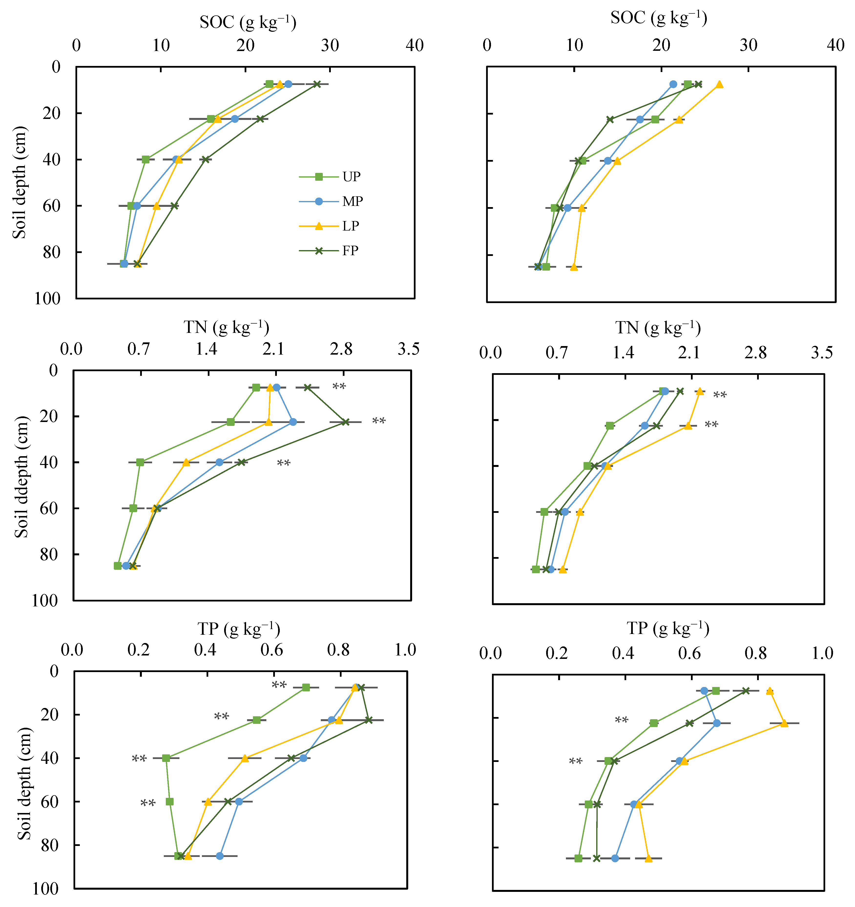
Soil OC, N, and P concentrations in the two cropland management systems significantly decreased with increasing soil depth except for increases of soil N concentration from 0–15 cm to 15–30 cm depth, while the decrease mainly occurred in 0–50 cm soils. Soil OC, N, and P concentrations significantly increased from the upper slope position to the lower slope position and footslope position (Figure 4). In sustainable cropland, soil OC, N, and P concentrations along the soil profiles were highest at the footslope position and lowest at the upper slope position, but those at the middle slope and lower slope positions varied with soil depth (Figure 4). For instance, soil OC, N, and P concentrations in sustainable cropland increased by 1.89, 0.40, and 0.22 g kg−1, 2.12, 2.80, and 1.56 g kg−1, and 5.04, 0.64, and 0.21 g kg−1 at the middle slope, lower slope and footslope positions compared with the upper slope position, respectively. In conventional cropland, soil OC, N, and P concentrations along the soil profiles were highest at the lower slope position and lowest at the upper slope position, but those at the middle slope and footslope positions varied with soil depth. For instance, soil organic carbon, nitrogen, and phosphorus concentrations in conventional cropland increased 0.02, 0.19, and 0.12 g kg−1, 3.33, 0.42, and 0.23 g kg−1, and −0.95, 0.20, and 0.06 g kg−1 at the middle slope, lower slope, and footslope positions compared with the upper slope position, respectively. When averaged across all slope positions, soil OC, N, and P concentrations were higher in the sustainable cropland than those in the conventional cropland (14.09 vs. 14.01 g kg−1 in OC concentration, 1.40 vs. 1.21 g kg−1 in N concentration, 0.57 vs. 0.51 g kg−1 in P concentration) (Figure 4).
Soil OC, N, and P stocks in the two cropland management systems significantly decreased with increasing soil depth (Table 2). Soil OC, N, and P stocks at different slope positions varied with soil depth and cropland management (Table 2). For instance, the averaged OC and N stocks followed the order of footslope > middle slope > lower slope > upper slope in 0–50 cm soils but followed the order of lower slope > footslope > middle slope > upper slope in 50–100 cm soils in sustainable cropland. However, the averaged organic carbon and nitrogen stocks in 0–100 cm soils followed the order of lower slope > middle slope > upper slope > footslope in conventional cropland. The difference in soil P stock among slope positions was not significant and differed with soil depth in the two cropland management systems. Soil OC, N, and P stocks, averaged across the slope positions, were higher in the sustainable cropland than those in the conventional cropland (i.e., 3.53 vs. 3.21 kg m−2 in OC stock, 0.35 vs. 0.27 kg m−2 in N stock, 0.15 vs. 0.11 kg m−2 in P stock) (Table 2).

4. Discussion

4.1. Effect of Slope Position and Cropland Management on Bulk Density and Saturated Hydraulic Conductivity

In this study, soil bulk density showed a decreasing trend from the upper slope position to the lower slope position in the conventional and sustainable croplands, which may be due to multiplex erosion (i.e., tillage, water, wind, and freeze-thaw erosion) that occurred in this site transporting the light and fine soil particles from the upper position and depositing them in the lower position, thus improving soil structure and decreasing soil bulk density [27,28,29,36,37]. Our observation is in line with the early results from Li et al. (2004) that soil redistribution by intensive tillage resulted in deterioration in soil quality within the tilled layer in the upper slope and temporary improvement in the lower slope [38]. In this study, a decrease in soil bulk density was observed from the upper to the lower slope position, while in the Oztas et al. [39] study the opposite was observed. This discrepancy is due to the difference in the land use, with eroded agricultural land in our study and grazed grassland in Oztas’ study. The grazing pressure at the footslope was almost higher than the upper landscape positions, resulting in soil compaction as well as higher bulk density at the lower slope. Meanwhile, the results revealed that in the sustainable cropland, soil bulk density was lowest at the footslope position, while in the conventional cropland, soil bulk density at the footslope position was only lower than that at the upper slope position. This discrepancy may be ascribed to the different management practices at the footslope position. Grassland at the footslope position of the sustainable cropland can effectively intercept the eroded sediment rich in organic matter, thereby reducing the soil BD. Meanwhile, the penetration of dense grassland roots and the cementation of residuals also play an important role in reducing soil BD [40,41]. In conventional cropland, the footslope position has a lower slope gradient, which facilitates mechanized sowing and harvesting, resulting in soil hardening and compaction [42,43,44]. In comparison, soil bulk density in the sustainable cropland was 0.13 g cm−3 (p = 0.002) lower than in the conventional cropland at 0–15 cm depth. This indicates that sustainable management in this study is effective for soil erosion control, which was also confirmed by the higher concentration in soil OC, N, and P (Figure 4). Furthermore, we also found that soil bulk density significantly increased with soil depth in the two cropland systems, which was probably due to the significant decrease of soil OC and nutrients with soil depth ( B D = 38.15 × O C + 67.78 ,   R 2 = 0.83 ;   B D = 3.59 × N + 6.35 ,   R 2 = 0.81 ; B D = 1.08 × T P + 2.07 ,   R 2 = 0.79 ), mechanical tillage of surface soil, and compaction of deep soil. This explanation was supported by our previous observation on the effect of land use change, soil erosion, and the years of reclamation on soil bulk density [25,44,45]. Contrary to the results of soil bulk density, we found that Ks increased from the upper slope position to the lower slope position in both cropland systems (Figure 2). This result is consistent with Walker and Lin [46], who showed that the depression areas had the highest mean surface Ks (10.2 cm h−1), while the summit areas had the lowest mean surface Ks (1.2 cm h−1).

4.2. Effect of Slope Position and Cropland Management on Water-Stable Aggregates

In this study, small macroaggregate increased and microaggregate decreased from the upper slope to the lower slope and footslope positions. One possible explanation was that soil erosion led to coarsening of the topsoil texture and loss of organic matter material at higher slope positions, which prevented the aggregation of soil particles. Another optional explanation was that tillage and water erosion transported the light and coarse soil particles with organic matter from a higher slope position to a lower slope position, which enhance the aggregation of micro-aggregates into macro-aggregates. On the one hand, the enhanced aggregation at a lower slope position was caused by depositional soil particles and organic materials resulting from soil erosion at a higher slope position [47,48,49]. On the other hand, higher biomass productivity at lower slope and footslope positions increased organic matter input and thus organic carbon concentration, enhancing aggregation of micro-aggregates into macro-aggregates. Therefore, the increase of small macroaggregate and decrease of microaggregate from upper slope position to lower slope position and footslope position, and the proportion of small macroaggregate were highest at the footslope position in the sustainable cropland and the lower slope position in the conventional cropland, respectively. The proportion of microaggregate was highest at the upper slope position and was greater at the footslope position than at the middle slope and lower slope positions in the sustainable cropland but only at the lower slope position in the conventional cropland. These results were consistent with observations in other regions [50,51,52]. However, we found that the effects of slope position and cropland managements on large macroaggregate and silt + clay fraction were weak (Figure 3 and Table 1), probably due to their smaller proportions within the soil mass, in particular the proportion of large macroaggregate (<5%).
The averaged values of large macroaggregate, small macroaggregate, and microaggregate across all slope positions were higher but the averaged silt + clay fraction was lower in the sustainable cropland than in the conventional cropland, while the difference was not statistically significant. The results were mainly attributed to the significant increase in large macroaggregate, small macroaggregate, and microaggregate and the decrease in silt + clay fraction at the footslope position in the sustainable cropland, but long-term cultivation and the same management practices at the upper slope, middle slope, and lower slope position did not significantly result in a difference in large macroaggregate, small macroaggregate, microaggregate and silt + clay fraction between sustainable and conventional cropland. The explanation was also supported by the results of the difference in soil OC, N, and P between the sustainable and the conventional cropland in this study, as discussed in the following section. Therefore, in agricultural watershed management, more attention should be paid to the footslope position, which plays an important role in improving soil structure.

4.3. Effect of Slope Position and Cropland Management on Organic Carbon, Nitrogen, and Phosphorus

In this study, soil OC, N, and P concentrations significantly increased from the upper to the lower slope position, probably due to the reduction in the thickness of the fertile black soil caused by tillage erosion and the transport of water erosion resulting in the leaching of OC, N, and P from the in situ soil of the higher slope positions. Furthermore, the decrease of OC, N, and P concentrations at higher slope positions could result in the reduction of crop productivity and thus the return of lower organic materials to the soil as crop litter, dead roots, and root exudates, accelerating further a decrease in soil OC, N, and P concentrations [51,53].
Our results indicated that soil OC, N, and P concentrations were highest at the footslope position in the sustainable cropland. While in the conventional cropland, soil OC, N, and P concentrations were highest at the lower slope position and those at the footslope position were consistent with those at the upper slope position. The difference in soil OC, N, and P concentrations at the footslope position was attributed to cropland management. In the sustainable cropland management system, grassland at the footslope position could intercept sloping runoff and carried sediment, which is often rich in organic materials and nutrients. In the conventional cropland management, ridge tillage at the footslope position, as discussed above in the previous section, resulted in poor soil structure and OC and nutrient environment. An alternative explanation is that grassland improved soil organic matter levels due to the diversity of litter, root exudates, and microbial populations. In the conventional cropland, the footslope position had higher soil water content and intense mechanical traces and thus the surface soil was compacted and sealed, which resulted in lower vertical leaching and transportation of soil OC, N, and P with runoff and fine soil particles at the footslope position. Moreover, long term mechanical tillage transported and deposited the larger sand at the footslope position and the poor physical and nutrient environment led to lower crop productivity and lower input of organic matter material, and therefore lower soil OC, N, and P concentrations. Consequently, although the soil particles and associated OC and nutrients were deposited and accumulated at the transect, lower aboveground biomass and little vertical transportation of OC and nutrients led to them being directly exposed to sunlight and air and thus becoming more decomposed in quantity. We observed that soil OC, N, and P concentrations were higher in the sustainable cropland than in the conventional cropland (Figure 4), but the increase was not significant. This was mainly due to the difference in fertilization in the two cropland management systems decreasing the effects of cropland management on soil OC, N, and P concentrations at the upper slope, middle slope, and lower slope positions, regardless of the significant increases in soil OC, N, and P concentrations at the footslope position in the sustainable cropland compared with the footslope position in the conventional cropland.
The results revealed that the stocks of soil OC, N, and P varied with slope position, soil depth, and cropland management, and the stocks of soil OC, N, and P in the sustainable cropland management system were 0.22, 0.08, and 0.04 kg m−2 higher than those in the conventional cropland management system, respectively. The results can probably be ascribed to the variation in the concentrations of soil OC, N, and P and soil BD as affected by slope position, soil depth, and cropland management [25]. In this study, the variation of soil BD was limited to slope positions, soil depth, and cropland management, but the concentrations of soil OC, N, and P significantly varied with slope position and soil depth, in particular the footslope position. Therefore, the responses of OC, N, and P stocks to the slope position and soil depth were mainly dominated by the changes in soil OC, N, and P concentrations. Hence, similar to the concentrations of OC, N, and P, soil OC, N, and P stocks in the two cropland management systems significantly decreased with increasing soil depth and were higher in sustainable cropland than in conventional cropland. The above results are important to further understand the spatial variation in soil properties along the slope positions in the small agricultural watershed scale, and in particular the important role of the location of the foot of the slope is highlighted. To improve the physicochemical properties of the soil, sustainable cropland management should be more widely promoted, especially for the footslope position, for example by conducting grassland management.

5. Conclusions

In this study, we assessed the changes in soil bulk density, Ks, water-stable aggregates, OC, N, and P with slope positions in the conventional cropland and sustainable cropland of a small agricultural watershed in the black soil region of northeast China. We found that the patterns of variation in soil properties with slope position were similar in the two cropland management systems, shown as soil BD, microaggregates decreased but the concentration of OC and nutrients, Ks, small-macroaggregate, increased from the upper slope position to the lower slope position. In comparison with the conventional cropland, the sustainable cropland has greater Ks, large-macroaggregate, small-macroaggregate, microaggregate, and concentrations and stocks of OC, N and P, but showed lower bulk density and silt + clay fraction. However, the prominent differences in both croplands were presented in the footslope position, which is ascribed to the interaction of cultivation, erosion, and cropland management. Therefore, sustainable cropland management practice has the potential to improve soil structure and prevent soil and nutrient loss. To better maintain soil fertility in agricultural watersheds in the black soil region of Northeast China, a sustainable agriculture pattern should be widely promoted.

Author Contributions

Conceptualization, X.W. and H.Z.; methodology, X.W., H.Z. and H.L.; validation, X.W.; formal analysis, H.Z. and H.L.; investigation, H.Z. and H.L.; resources, X.W.; data curation, H.Z. and H.L.; software, H.Z., H.L., C.L. and X.C.; writing—original draft preparation, H.Z. and H.L.; writing—review and editing, H.Z., H.L., X.W. and X.Z.; visualization, H.Z. and H.L.; supervision, X.W.; project administration, X.W. All authors have read and agreed to the published version of the manuscript.

Funding

This study was supported by the Strategic Priority Research Program of the Chinese Academy of Sciences (XDB40000000), the National Key Research and Development Program (2018YFC0507001), the National Natural Science Foundation of China (41977068) and programs from Chinese Academy of Sciences (QYZDB-SSW-DQC039).

Data Availability Statement

The data are contained within the article.

Acknowledgments

We thank Baoyuan Liu, Yun Xie and Gang Liu from Beijing Normal University for the help with sampling.

Conflicts of Interest

The authors declare no conflict of interest.

References

  1. Zhao, P.; Li, S.; Wang, E.; Chen, X.; Deng, J.; Zhao, Y. Tillage erosion and its effect on spatial variations of soil organic carbon in the black soil region of China. Soil Tillage Res. 2018, 178, 72–81. [Google Scholar] [CrossRef]
  2. Wang, H.; Yang, S.; Wang, Y.; Gu, Z.; Xiong, S.; Huang, X.; Sun, M.; Zhang, S.; Guo, L.; Cui, J.; et al. Rates and causes of black soil erosion in Northeast China. Catena 2022, 214, 106250. [Google Scholar] [CrossRef]
  3. Huang, D.; Su, L.; Zhou, L.; Fan, H. Gully is the dominant sediment source of snowmelt erosion in the black soil region—A case study. Soil Tillage Res. 2022, 215, 105232. [Google Scholar] [CrossRef]
  4. Behnke, G.D.; Zuber, S.M.; Pittelkow, C.M.; Nafziger, E.D.; Villamil, M.B. Long-term crop rotation and tillage effects on soil greenhouse gas emissions and crop production in Illinois, USA. Agric. Ecosyst. Environ. 2018, 261, 62–70. [Google Scholar] [CrossRef]
  5. Ran, L.; Shi, H.; Yang, X. Magnitude and drivers of CO2 and CH4 emissions from an arid/semiarid river catchment on the Chinese Loess Plateau. J. Hydrol. 2021, 598, 126260. [Google Scholar] [CrossRef]
  6. Maleki, S.; Karimi, A.; Zeraatpisheh, M.; Poozeshi, R.; Feizi, H. Long-term cultivation effects on soil properties variations in different landforms in an arid region of eastern Iran. Catena 2021, 206, 105465. [Google Scholar] [CrossRef]
  7. Cavalcanti, R.Q.; Rolim, M.M.; De Lima, R.P.; Tavares, U.E.; Pedrosa, E.M.; Gomes, I.F. Soil physical and mechanical attributes in response to successive harvests under sugarcane cultivation in Northeastern Brazil. Soil Tillage Res. 2019, 189, 140–147. [Google Scholar] [CrossRef]
  8. Lu, S.; Liu, B.; Hu, Y.; Fu, S.; Cao, Q.; Shi, Y.; Huang, T. Soil erosion topographic factor (LS): Accuracy calculated from different data sources. Catena 2020, 187, 104334. [Google Scholar] [CrossRef]
  9. Jin, F.; Yang, W.; Fu, J.; Li, Z. Effects of vegetation and climate on the changes of soil erosion in the Loess Plateau of China. Sci. Total Environ. 2021, 773, 145514. [Google Scholar] [CrossRef]
  10. Ma, Y.; Li, Z.; Deng, C.; Yang, J.; Tang, C.; Duan, J.; Zhang, Z.; Liu, Y. Effects of tillage-induced soil surface roughness on the generation of surface–subsurface flow and soil loss in the red soil sloping farmland of southern China. Catena 2022, 213, 106230. [Google Scholar] [CrossRef]
  11. Liu, Z.; Cao, S.; Sun, Z.; Wang, H.; Qu, S.; Lei, N.; He, J.; Dong, Q. Tillage effects on soil properties and crop yield after land reclamation. Sci. Rep. 2021, 11, 4611. [Google Scholar] [CrossRef] [PubMed]
  12. Tepes, A.; Galarraga, I.; Markandya, A.; Sánchez, M.J.S. Costs and benefits of soil protection and sustainable land management practices in selected European countries: Towards multidisciplinary insights. Sci. Total Environ. 2021, 756, 143925. [Google Scholar] [CrossRef] [PubMed]
  13. Lessmann, M.; Ros, G.H.; Young, M.D.; de Vries, W. Global variation in soil carbon sequestration potential through improved cropland management. Glob. Chang. Biol. 2022, 28, 1162–1177. [Google Scholar] [CrossRef] [PubMed]
  14. Tagar, A.A.; Adamowski, J.; Memon, M.S.; Do, M.C.; Mashori, A.S.; Soomro, A.S.; Bhayo, W.A. Soil fragmentation and aggregate stability as affected by conventional tillage implements and relations with fractal dimensions. Soil Tillage Res. 2020, 197, 104494. [Google Scholar] [CrossRef]
  15. Xiao, L.; Kuhn, N.; Zhao, R.; Cao, L. Net effects of conservation agriculture principles on sustainable land use: A synthesis. Glob. Chang. Biol. 2021, 27, 6321–6330. [Google Scholar] [CrossRef]
  16. Panettieri, M.; de Sosa, L.; Domínguez, M.; Madejón, E. Long-term impacts of conservation tillage on Mediterranean agricultural soils: Shifts in microbial communities despite limited effects on chemical properties. Agric. Ecosyst. Environ. 2020, 304, 107144. [Google Scholar] [CrossRef]
  17. Anache, J.A.; Wendland, E.C.; Oliveira, P.T.; Flanagan, D.C.; Nearing, M.A. Runoff and soil erosion plot-scale studies under natural rainfall: A meta-analysis of the Brazilian experience. Catena 2017, 152, 29–39. [Google Scholar] [CrossRef]
  18. Yang, J.; El-Kassaby, Y.A.; Guan, W. The effect of slope aspect on vegetation attributes in a mountainous dry valley, Southwest China. Sci. Rep. 2020, 10, 16465. [Google Scholar] [CrossRef]
  19. Niu, Y.H.; Wang, L.; Wan, X.G.; Peng, Q.Z.; Huang, Q.; Shi, Z.H. A systematic review of soil erosion in citrus orchards worldwide. Catena 2021, 206, 105558. [Google Scholar] [CrossRef]
  20. Dai, J.; Zhang, J.; Zhang, Z.; Jia, L.; Xu, H.; Wang, Y. Effects of water discharge rate and slope gradient on runoff and sediment yield related to tillage erosion. Arch. Agron. Soil Sci. 2021, 67, 849–861. [Google Scholar] [CrossRef]
  21. Lin, J.; Huang, Y.; Zhao, G.; Jiang, F.; Wang, M.K.; Ge, H. Flow-driven soil erosion processes and the size selectivity of eroded sediment on steep slopes using colluvial deposits in a permanent gully. Catena 2017, 157, 47–57. [Google Scholar] [CrossRef]
  22. Tuo, D.; Xu, M.; Gao, G. Relative contributions of wind and water erosion to total soil loss and its effect on soil properties in sloping croplands of the Chinese Loess Plateau. Sci. Total Environ. 2018, 633, 1032–1040. [Google Scholar] [CrossRef] [PubMed]
  23. Bojko, O.; Kabala, C. Transformation of physicochemical soil properties along a mountain slope due to land management and climate changes—A case study from the Karkonosze Mountains, SW Poland. Catena 2016, 140, 43–54. [Google Scholar] [CrossRef]
  24. Xu, M.; Cardenas, L.; Horrocks, C.; Lopez-Aizpun, M.; Zhang, J.; Zhang, F.; Dungait, J. The effect of tillage management on microbial functions in a maize crop at different slope positions. Geoderma 2021, 401, 115171. [Google Scholar] [CrossRef]
  25. Li, H.; Liao, X.; Zhu, H.; Wei, X.; Shao, M. Soil physical and hydraulic properties under different land uses in the black soil region of Northeast China. Can. J. Soil Sci. 2019, 99, 406–419. [Google Scholar] [CrossRef]
  26. USDA. Soil Taxonomy: A Basic System of Soil Classification for Making and Interpreting Soil Survey; Government Printing Office: Washington, DC, USA, 1975.
  27. Zhang, Y.; Wu, Y.; Liu, B.; Zheng, Q.; Yin, J. Characteristics and factors controlling the development of ephemeral gullies in cultivated catchments of black soil region, Northeast China. Soil Tillage Res. 2007, 96, 28–41. [Google Scholar] [CrossRef]
  28. Li, Q.; Fang, H.; Sun, L.; Cai, Q. Using the 137Cs technique to study the effect of soil redistribution on soil organic carbon and total nitrogen stocks in an agricultural catchment of Northeast China. Land Degrad. Dev. 2012, 25, 350–359. [Google Scholar] [CrossRef]
  29. Dong, Y.; Wu, Y.; Qin, W.; Guo, Q.; Yin, Z.; Duan, X. The gully erosion rates in the black soil region of northeastern China: Induced by different processes and indicated by different indexes. Catena 2019, 182, 104146. [Google Scholar] [CrossRef]
  30. Nelson, D.W.; Sommers, L.E. Methods of soil analysis: Part 3 Chemical methods. In Total Carbon, Organic Carbon, and Organic Matter; Sparks, D.L., Ed.; Soil Science Society of America: Madison, WI, USA, 1996; pp. 961–1010. [Google Scholar]
  31. Kjeldahl, C. A new method for the determination of nitrogen in organic matter. Anal. Chem. 1883, 22, 366. [Google Scholar] [CrossRef] [Green Version]
  32. Olsen, S.R.; Sommers, L.E. Methods of soil analysis Part 2, Chemical and microbial properties. In Phosphorous; Miller, R.H., Keeney, D.R., Eds.; Agronomy Society of America: Madison, WI, USA, 1982; pp. 403–430. [Google Scholar]
  33. Six, J.; Elliott, E.T.; Paustian, K.; Doran, J.W. Aggregation and soil organic matter accumulation in cultivated and native grassland soils. Soil Sci. Soc. Am. J. 1998, 62, 1367–1377. [Google Scholar] [CrossRef]
  34. Klute, A.; Dirksen, C. Methods of soil analysis, part 1: Physical and mineralogical methods. In Hydraulic Conductivity and Diffusivity: Laboratory Methods, 2nd ed.; Klute, A., Ed.; Agronomy Society of America: Madison, WI, USA, 1986; pp. 687–734. [Google Scholar]
  35. Liu, L.; Lu, Y.; Fu, Y.; Horton, R.; Ren, T. Estimating soil water suction from texture, bulk density and electrical resistivity. Geoderma 2022, 409, 115630. [Google Scholar] [CrossRef]
  36. Shi, P.; Schulin, R. Erosion-induced losses of carbon, nitrogen, phosphorus and heavy metals from agricultural soils of contrasting organic matter management. Sci. Total Environ. 2018, 618, 210–218. [Google Scholar] [CrossRef]
  37. Heckrath, G.; Halekoh, U.; Djurhuus, J.; Govers, G. The effect of tillage direction on soil redistribution by mouldboard ploughing on complex slopes. Soil Tillage Res. 2006, 88, 225–241. [Google Scholar] [CrossRef]
  38. Li, Y.; Tian, G.; Lindstrom, M.; Bork, H. Variation of surface soil quality parameters by intensive donkey-drawn tillage on steep slope. Soil Sci. Soc. Am. J. 2004, 68, 907–913. [Google Scholar] [CrossRef]
  39. Oztas, T.; Koc, A.; Comakli, B. Changes in vegetation and soil properties along a slope on overgrazed and eroded rangelands. J. Arid Environ. 2003, 55, 93–100. [Google Scholar] [CrossRef]
  40. Zou, C.B.; Turton, D.J.; Will, R.E.; Engle, D.M.; Fuhlendorf, S.D. Alteration of hydrological processes and streamflow with juniper (Juniperus virginiana) encroachment in a mesic grassland catchment. Hydrol. Process. 2014, 28, 6173–6182. [Google Scholar] [CrossRef]
  41. Morse, J.L.; Megonigal, J.P.; Walbridge, M.R. Sediment nutrient accumulation and nutrient availability in two tidal freshwater marshes along the Mattaponi River, Virginia, USA. Biogeochemistry 2004, 69, 175–206. [Google Scholar] [CrossRef]
  42. Kirchhof, G.; Salako, F.K. Residual tillage and bush-fallow effects on soil properties and maize intercropped with legumes on a tropical Alfisol. Soil Use Manag. 2000, 16, 183–188. [Google Scholar] [CrossRef]
  43. Celik, I.; Gunal, H.; Budak, M.; Akpinar, C. Effects of long-term organic and mineral fertilizers on bulk density and penetration resistance in semi-arid Mediterranean soil conditions. Geoderma 2010, 160, 236–243. [Google Scholar] [CrossRef]
  44. Li, H.; Zhu, H.; Liang, C.; Wei, X.; Yao, Y. Soil erosion significantly decreases aggregate-associated OC and N in agricultural soils of Northeast China. Agric. Ecosyst. Environ. 2022, 323, 107677. [Google Scholar] [CrossRef]
  45. Li, H.; Yao, Y.; Zhang, X.; Zhu, H.; Wei, X. Changes in soil physical and hydraulic properties following the conversion of forest to cropland in the black soil region of Northeast China. Catena 2021, 198, 104986. [Google Scholar] [CrossRef]
  46. Walker, C.; Lin, H.S. Soil property changes after four decades of wastewater irrigation: A landscape perspective. Catena 2008, 73, 63–74. [Google Scholar] [CrossRef]
  47. Badía, D.; Martí, C.; Aznar, J.M.; León, J. Influence of slope and parent rock on soil genesis and classification in semiarid mountainous environments. Geoderma 2013, 193, 13–21. [Google Scholar] [CrossRef]
  48. Rodenburg, J.; Stein, A.; van Noordwijk, M.; Ketterings, Q.M. Spatial variability of soil pH and phosphorus in relation to soil run-off following slash-and-burn land clearing in Sumatra, Indonesia. Soil Tillage Res. 2003, 71, 1–14. [Google Scholar] [CrossRef]
  49. Hao, Y.; Lal, R.; Owens, L.B.; Izaurralde, R.C.; Post, W.M.; Hothem, D.L. Effect of cropland management and slope position on soil organic carbon pool at the North Appalachian Experimental Watersheds. Soil Tillage Res. 2002, 68, 133–142. [Google Scholar] [CrossRef]
  50. Hoyos, N.; Comerford, N.B. Land use and landscape effects on aggregate stability and total carbon of Andisols from the Colombian Andes. Geoderma 2005, 129, 268–278. [Google Scholar] [CrossRef]
  51. Ayoubi, S.; Karchegani, P.M.; Mosaddeghi, M.R.; Honarjoo, N. Soil aggregation and organic carbon as affected by topography and land use change in western Iran. Soil Tillage Res. 2012, 121, 18–26. [Google Scholar] [CrossRef]
  52. Pierson, F.B.; Mulla, D.J. Aggregate stability in the Palouse region of Washington: Effect of landscape position. Soil Sci. Soc. Am. J. 1990, 54, 1407–1412. [Google Scholar] [CrossRef]
  53. Ricci, G.F.; Jeong, J.; De Girolamo, A.M.; Gentile, F. Effectiveness and feasibility of different management practices to reduce soil erosion in an agricultural watershed. Land Use Policy 2020, 90, 104306. [Google Scholar] [CrossRef]
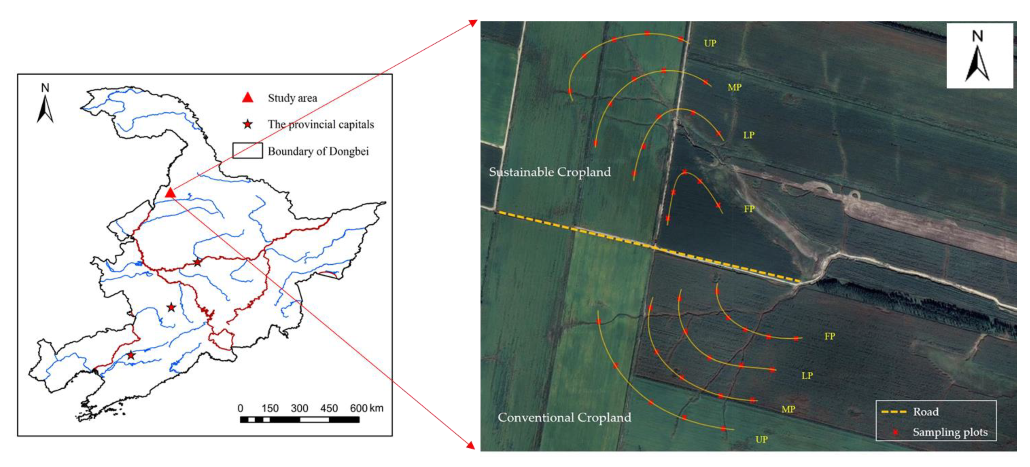
Figure 1. Location of the study site in the black soil region of Northeast China. Distribution of sampling plots in sustainable cropland and conventional cropland. UP: upper slope position; MP: middle slope position; LP: lower slope position; FP: footslope position.
Agronomy 12 02457 g001
Figure 2. Profile distribution of soil bulk density (BD) and Ks at upper slope (UP), middle slope (MP), lower slope (LP), and footslope positions (FP) in sustainable cropland (left) and in conventional cropland (right). Ks: saturated hydraulic conductivity. The error bars are two standard errors of the means. ** indicates that the difference among different slope positions is significant at p < 0.05.
Agronomy 12 02457 g002aAgronomy 12 02457 g002b
Figure 3. Profile distribution of water-stable aggregates at upper slope (UP), middle slope (MP), lower slope (LP), and footslope positions (FP) in sustainable cropland (left) and in conventional cropland (right). LMA: large macroaggregate (>2 mm); SMA: small macroaggregate (0.25–2 mm); MI: microaggregate (0.053–2 mm); SC: silt + clay fraction (<0.053 mm). The error bars are two standard errors of the means. ** indicates that the difference among different slope positions is significant at p < 0.05.
Agronomy 12 02457 g003aAgronomy 12 02457 g003b
Figure 4. Profile distribution of soil organic matter, total nitrogen, and total phosphorus concentrations at upper slope (UP), middle slope (MP), lower slope (LP), and footslope positions (FP) in sustainable cropland (left) and in conventional cropland (right). SOC: soil organic carbon concentration; TN: total nitrogen concentration; TP: total phosphorus concentration. The error bars are two standard errors of the means. ** indicates that the difference among different slope positions is significant at p < 0.05.
Agronomy 12 02457 g004
Table 1. Multi-Factor ANOVA for LMA, SMA, MI, and SC as affected by slope position, cropland management system, and depth.
LMASMAMISC
FPFPFPFP
SP1.580.2516.56<0.018.59<0.011.160.36
CMS2.480.142.260.162.660.1298.130.02
D161.66<0.0179.920.0731.160.13731.630.42
SP × CMS6.81<0.013.07<0.012.23<0.011.02<0.01
SP × D0.710.720.690.740.810.6380.580.82
CMS × D1.600.243.540.042.970.065.52<0.01
LMA: large macroaggregate (>2 mm); SMA: small macroaggregate (0.25–2 mm); MI: microaggregate (0.053–2 mm); SC: silt + clay fraction (<0.053 mm); SP: slope position; CMS: cropland management system; D: depth.
Table 2. Effect of slope position (i.e., upper slope, middle slope, lower slope, and footslope positions) on the stocks of organic carbon, total nitrogen, and total phosphorus at different depths of the two different cropland management systems (i.e., sustainable cropland and conventional cropland).
ManagementDepth
(cm)
Organic Carbon Stock (kg m−2)Total Nitrogen Stock (kg m−2)Total Phosphorus Stock (kg m−2)
UpperMiddleLowerFootslopeUpperMiddleLowerFootslopeUpperMiddleLowerFootslope
Sustainable
cropland
0–153.94 ± 0.064.19 ± 0.164.05 ± 0.164.34 ± 0.140.33 ± 0.020.35 ± 0.060.34 ± 0.030.37 ± 0.040.09 ± 0.020.14 ± 0.030.14 ± 0.030.13 ± 0.02
15–303.54 ± 0.193.63 ± 0.133.19 ± 0.124.47 ± 0.130.32 ± 0.07 b0.43 ± 0.04 ab0.40 ± 0.09 ab0.55 ± 0.01 a0.15 ± 0.050.12 ± 0.020.15 ± 0.050.15 ± 0.03
30–502.53 ± 0.183.58 ± 0.253.43 ± 0.114.38 ± 0.150.20 ± 0.06 b0.52 ± 0.09 a0.35 ± 0.08 ab0.57 ± 0.06 a0.09 ± 0.030.22 ± 0.050.15 ± 0.020.19 ± 0.02
50–702.05 ± 0.152.80 ± 0.163.23 ± 0.153.16 ± 0.160.20 ± 0.050.31 ± 0.050.28 ± 0.030.26 ± 0.040.09 ± 0.030.18 ± 0.020.13 ± 0.040.13 ± 0.03
70–1002.66 ± 0.223.07 ± 0.144.37 ± 0.174.05 ± 0.140.24 ± 0.080.28 ± 0.040.36 ± 0.060.34 ± 0.090.18 ± 0.020.25 ± 0.060.19 ± 0.060.16 ± 0.02
0–10014.73 ± 0.10 b17.27 ± 0.17 ab18.28 ± 0.15 ab20.39 ± 0.18 a1.30 ± 0.06 b1.89 ± 0.08 a1.72 ± 0.08 a2.10 ± 0.05 a0.60 ± 0.060.91 ± 0.070.76 ± 0.070.77 ± 0.05
Conventional
cropland
0–154.42 ± 0.043.91 ± 0.154.72 ± 0.143.83 ± 0.150.34 ± 0.010.34 ± 0.080.40 ± 0.050.32 ± 0.050.13 ± 0.010.13 ± 0.040.14 ± 0.020.12 ± 0.03
15–303.68 ± 0.14 ab3.86 ± 0.14 ab4.79 ± 0.16 a2.09 ± 0.10 b0.21 ± 0.05 b0.35 ± 0.04 ab0.41 ± 0.08 a0.26 ± 0.04 ab0.09 ± 0.03 c0.14 ± 0.01 ab0.17 ± 0.03 a0.09 ± 0.02 bc
30–502.81 ± 0.154.02 ± 0.082.66 ± 0.131.90 ± 0.120.31 ± 0.090.37 ± 0.040.21 ± 0.010.20 ± 0.080.10 ± 0.050.12 ± 0.040.11 ± 0.050.08 ± 0.03
50–702.18 ± 0.113.18 ± 0.071.84 ± 0.131.82 ± 0.130.15 ± 0.040.25 ± 0.030.22 ± 0.050.17 ± 0.040.09 ± 0.060.10 ± 0.020.08 ± 0.020.07 ± 0.02
70–1003.01 ± 0.042.68 ± 0.254.41 ± 0.142.47 ± 0.170.21 ± 0.010.28 ± 0.090.23 ± 0.090.24 ± 0.030.13 ± 0.030.13 ± 0.050.14 ± 0.040.14 ± 0.02
0–10016.10 ± 0.26 ab17.66 ± 0.19 ab18.43 ± 0.15 a12.10 ± 0.14 b1.23 ± 0.071.59 ± 0.071.47 ± 0.061.19 ± 0.060.54 ± 0.040.61 ± 0.060.63 ± 0.050.52 ± 0.04
Different letters in the same column represent significant differences among treatments at a significance level of p < 0.05.
Publisher’s Note: MDPI stays neutral with regard to jurisdictional claims in published maps and institutional affiliations.