A Simplified Method for UAV Multispectral Images Mosaicking

Abstract
:
1. Introduction
2. Related Research
3. Methodology
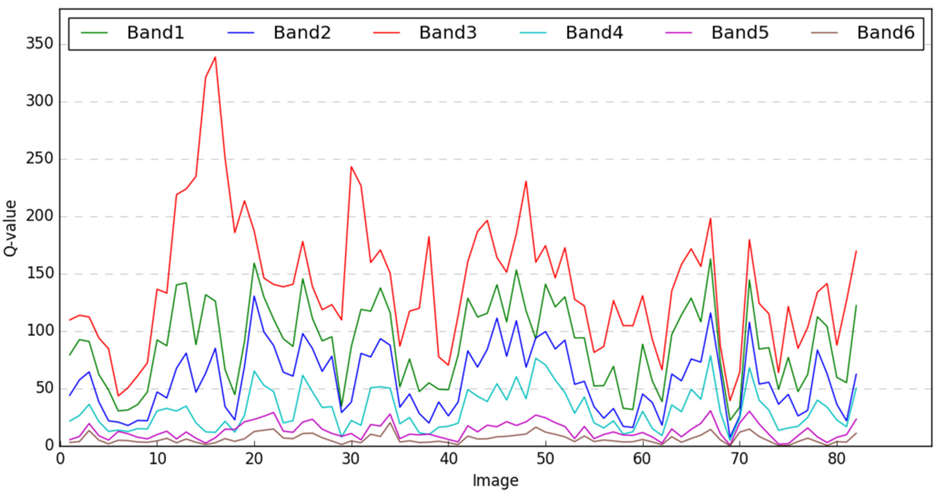
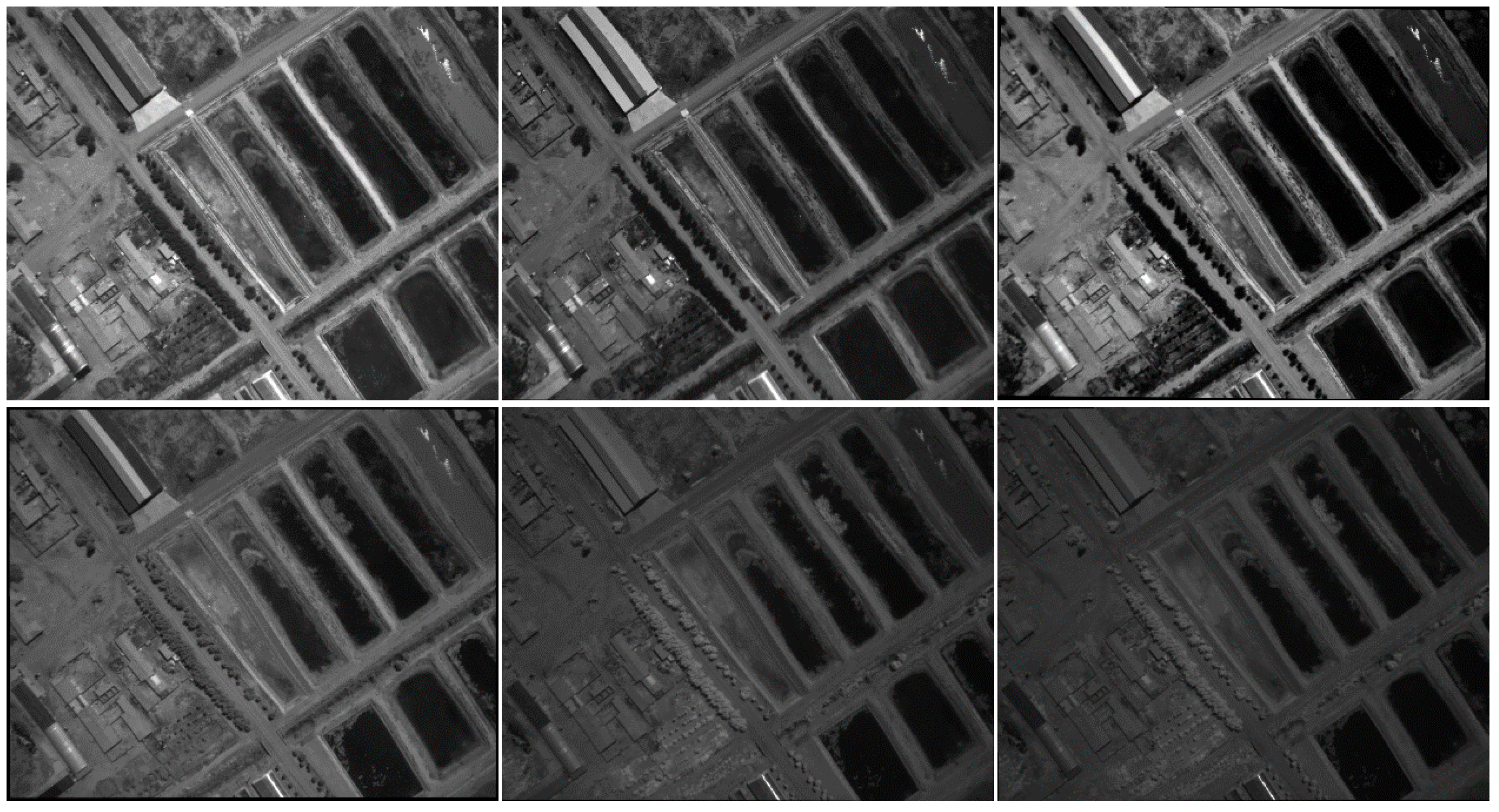
3.1. Selecting the Optimal Band for Feature Matching
3.2. The Simplified Projection Model
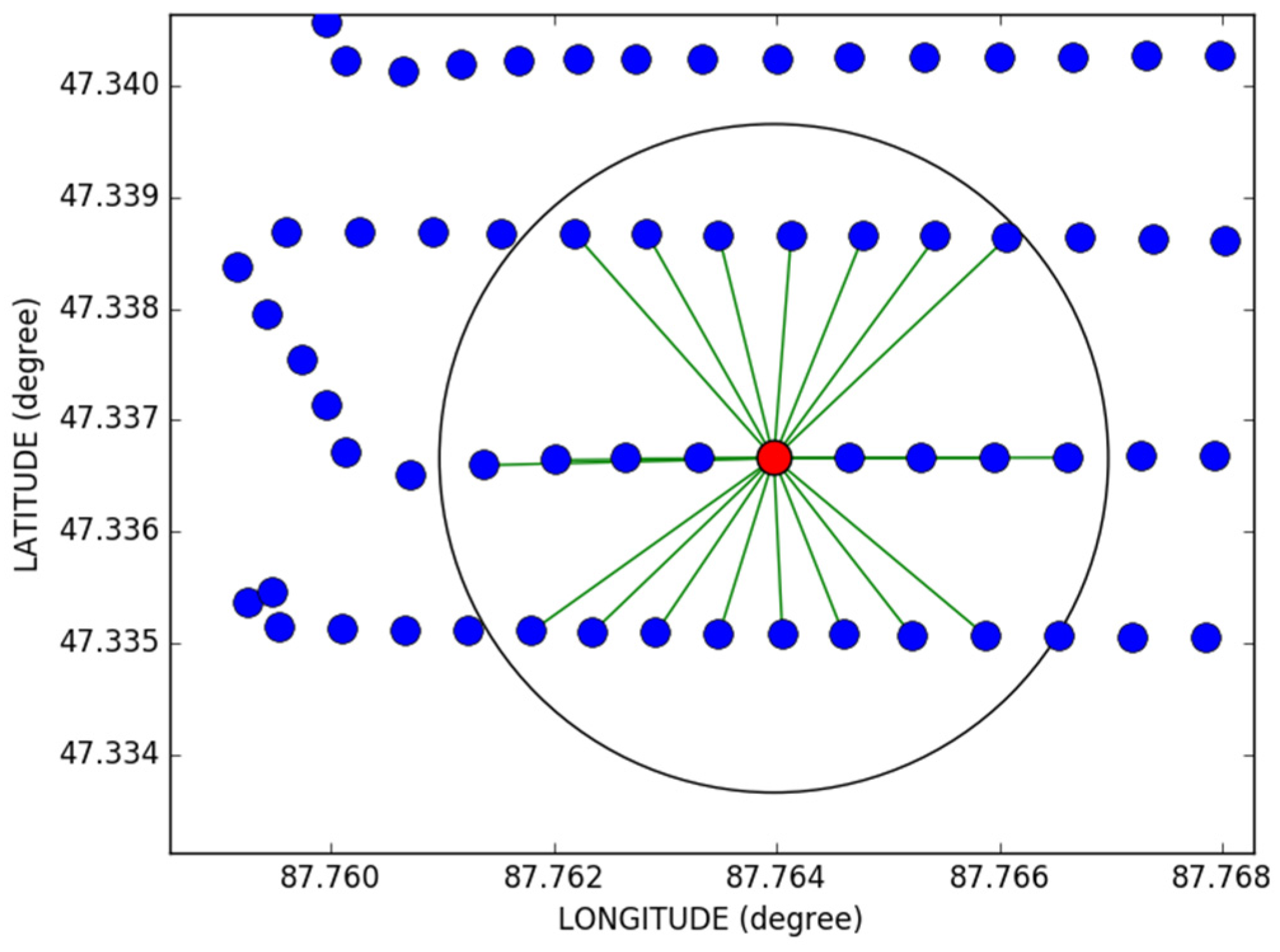
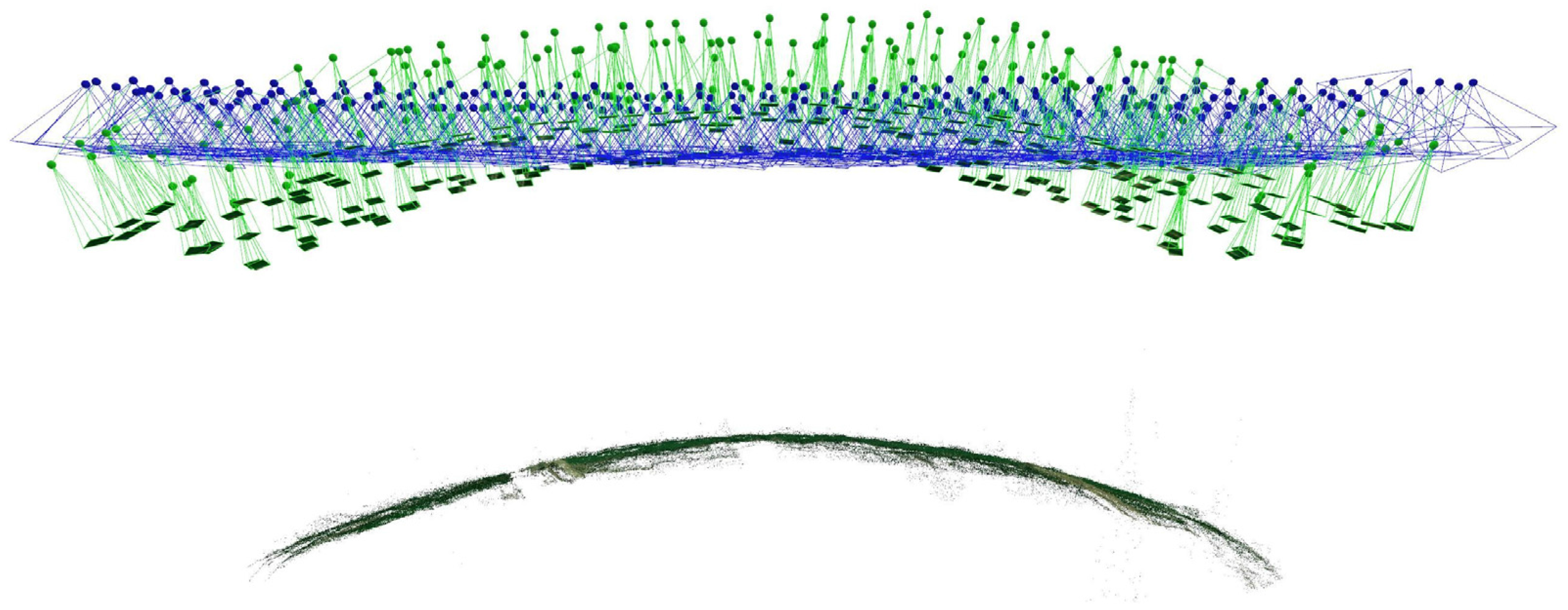
3.3. Estimation of the Possible Overlapping Relations
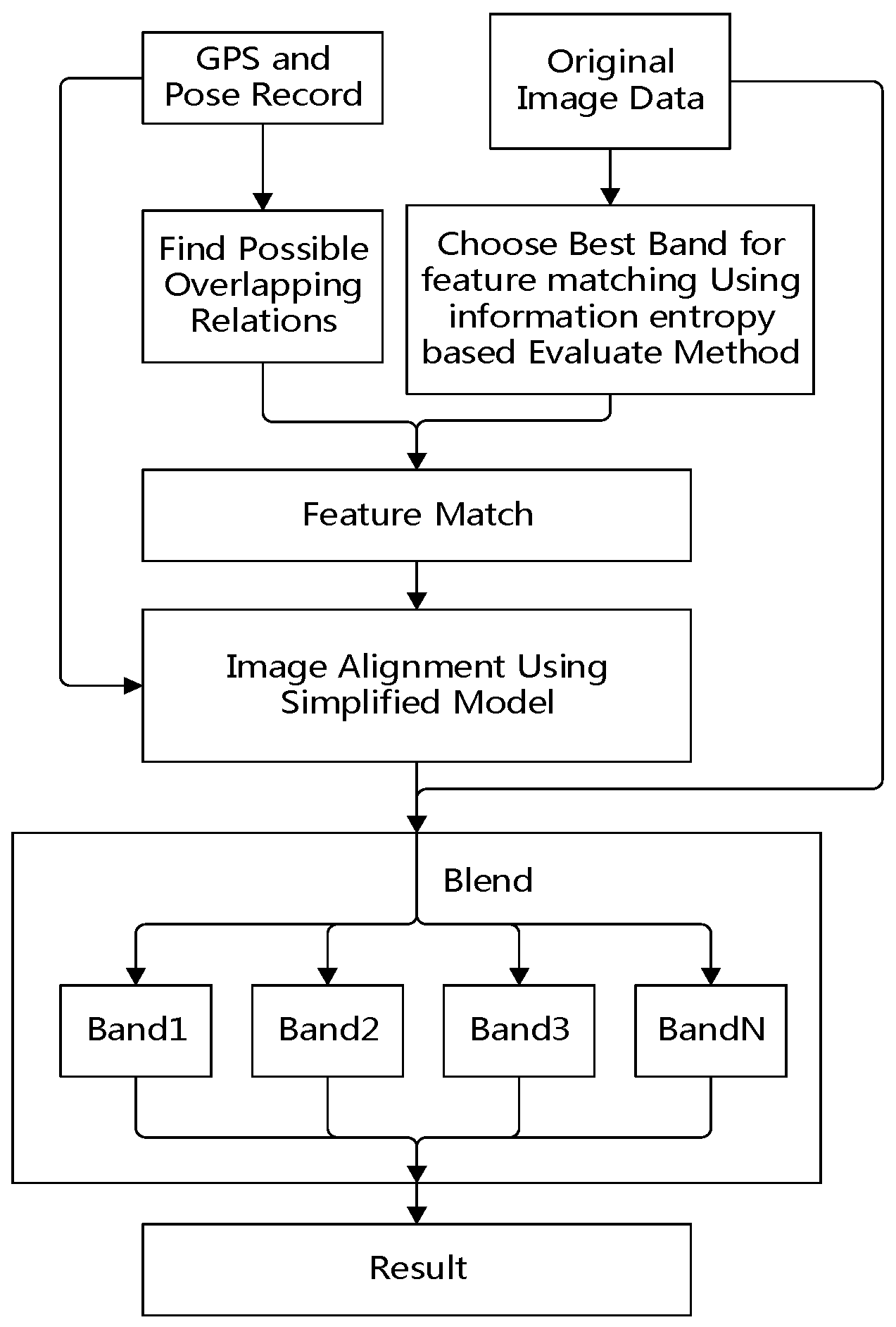
3.4. The Workflow of the Proposed Method
- Pickup sample images according to a fixed interval, such as every three or five images for feature quality estimation.
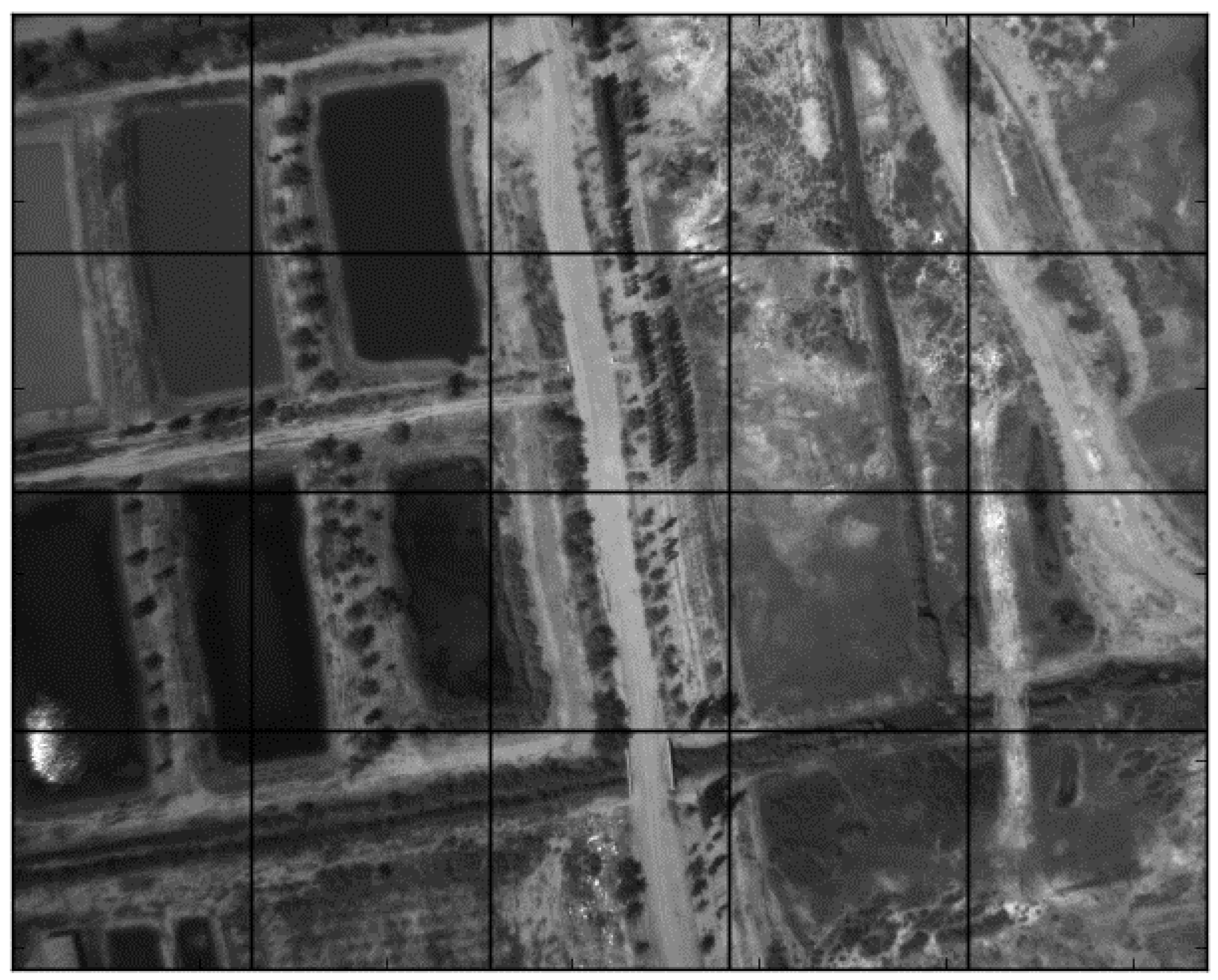
- Divide every band image into several sub areas as close to the square as possible.
- Detect SIFT feature points on all the bands of the images.
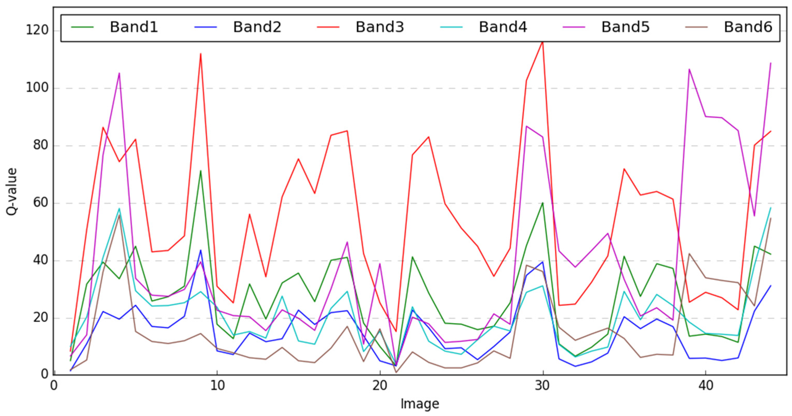
- For every band of each frame of the image, calculate the using Equation (3).
- Calculate the of each band among all the sample images using Equation (4).
- The band that has the highest will be used for feature matching.
- Try matching the two images using the optimal band selected in Step 1. The matched point pair set is .
- If is less than (in this research is set to 30), redo the optimal band evaluation according Step 1 on only these two images, and use the new optimal band to re-match the image pair. The new matched point pair set is .
- If is still less than , continue matching with the band that has the second highest in the re-evaluation result until exceeds , or every band of the two images is matched.
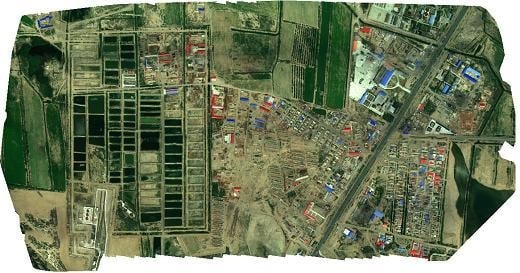
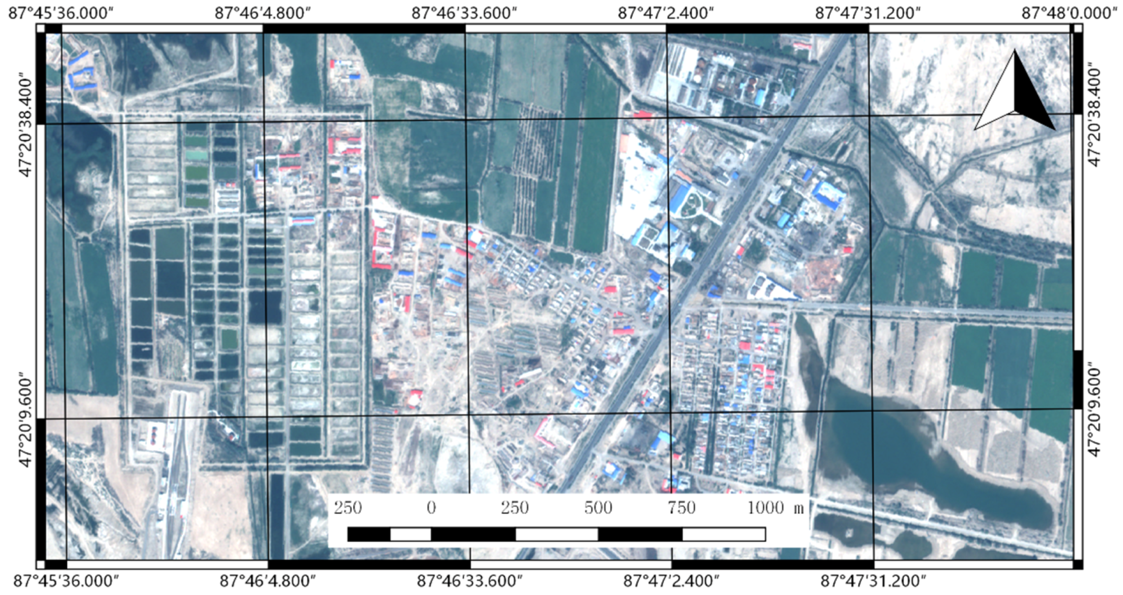
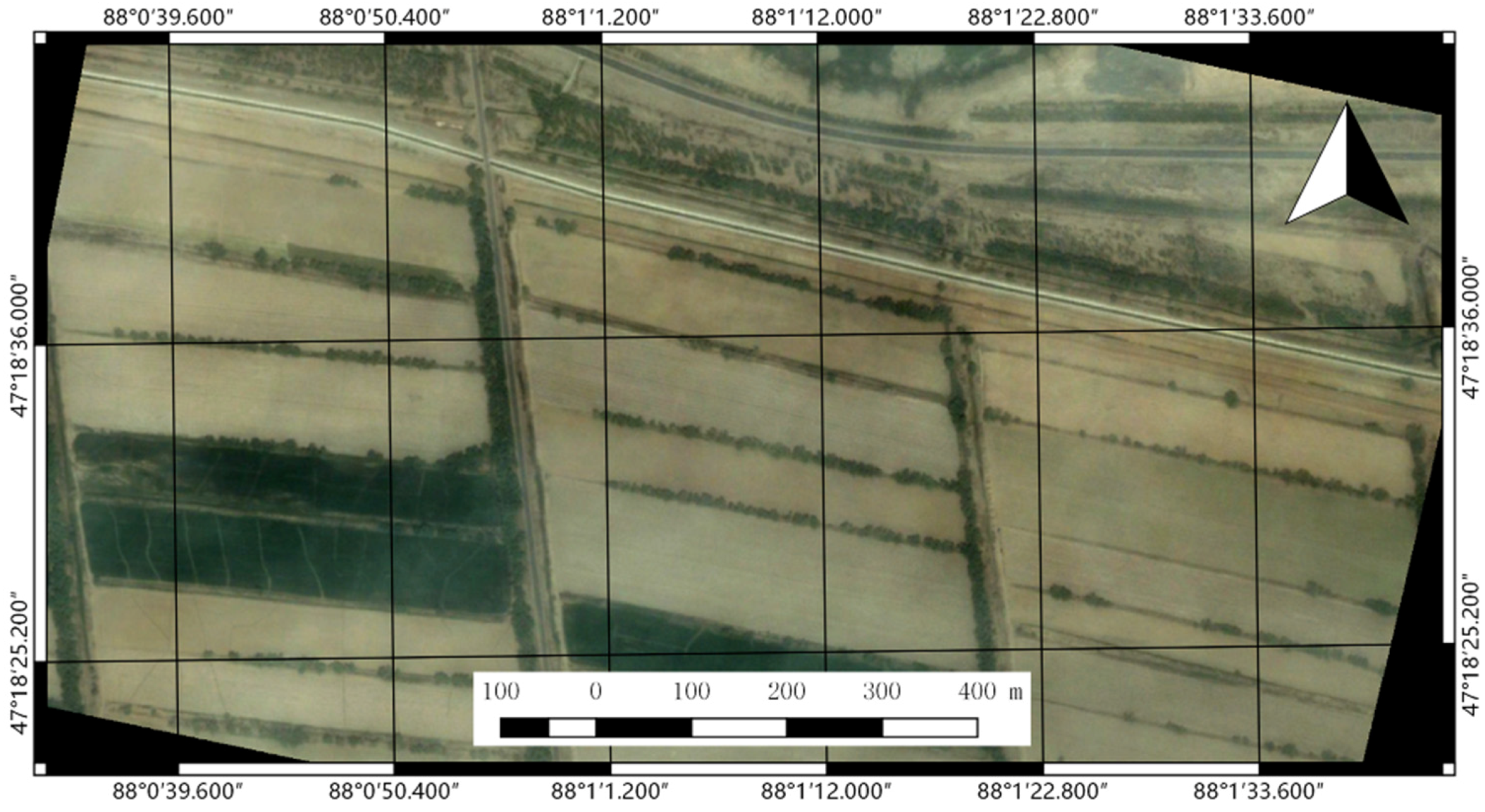
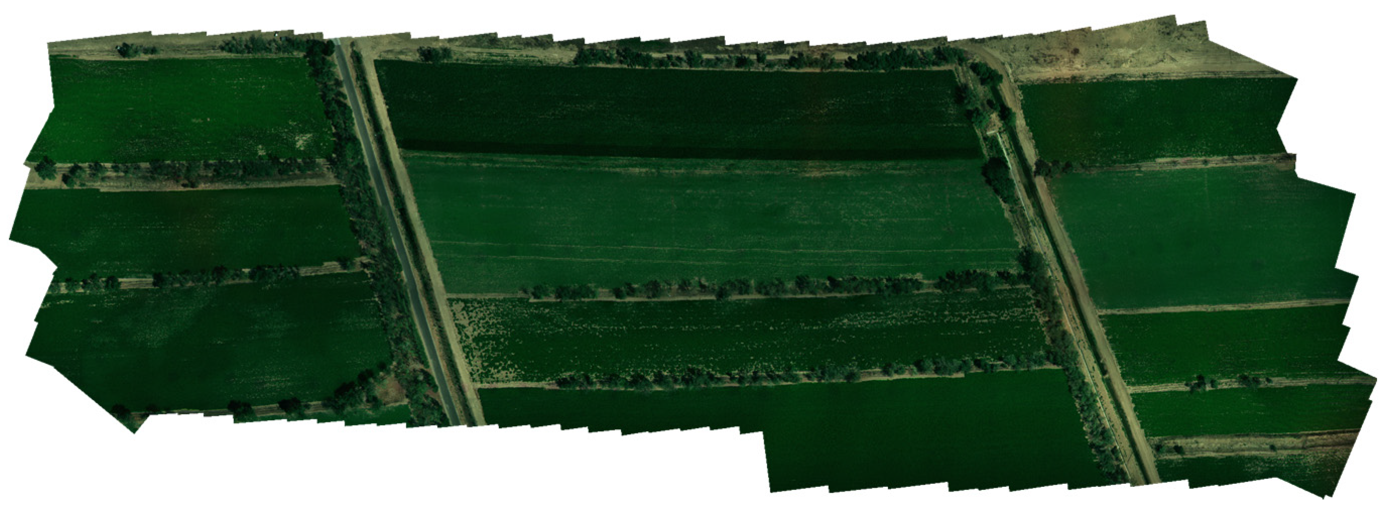
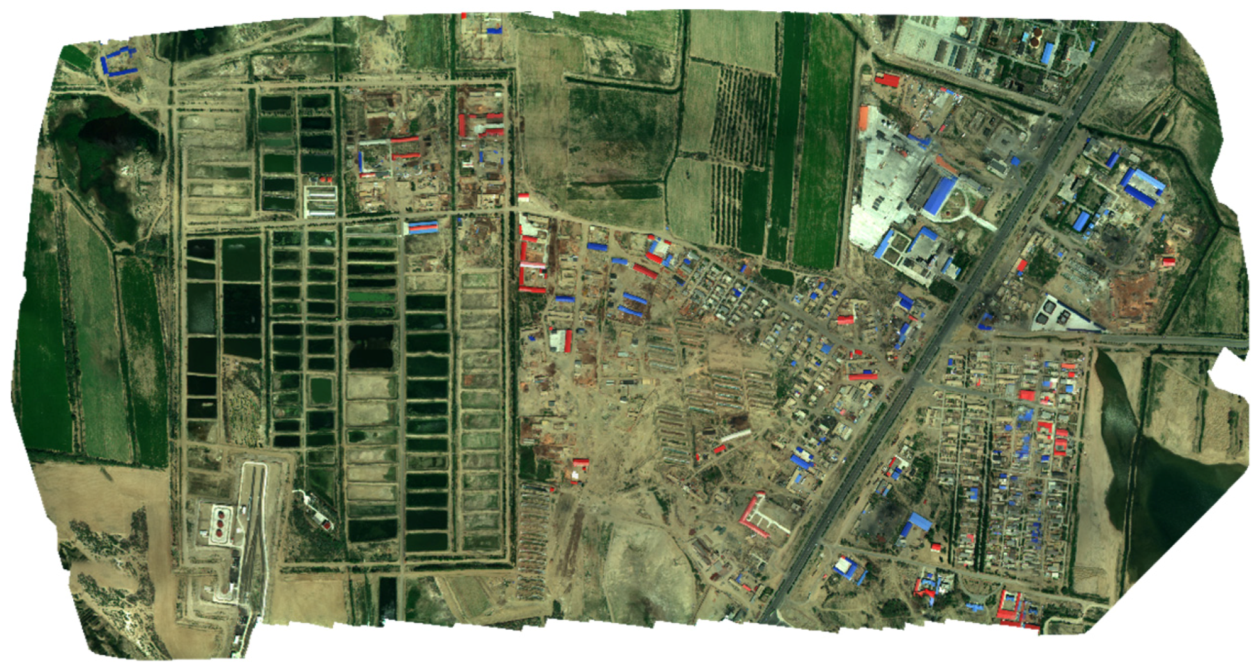
4. Datasets
5. Experiment Results
5.1. Selection of the Optimal Band for Feature Matching
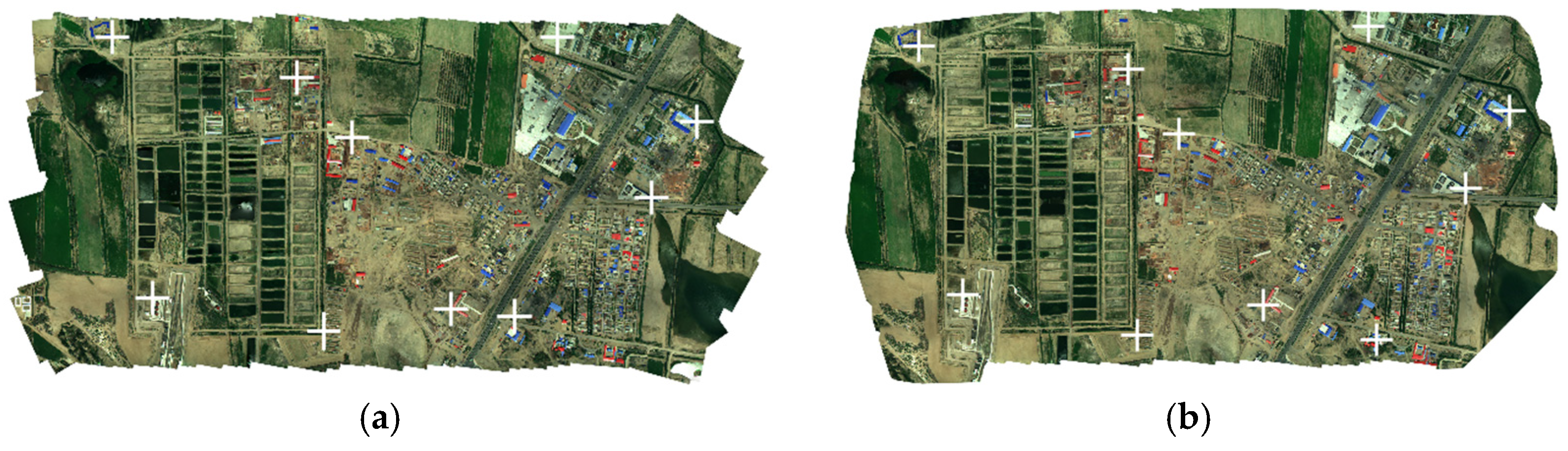
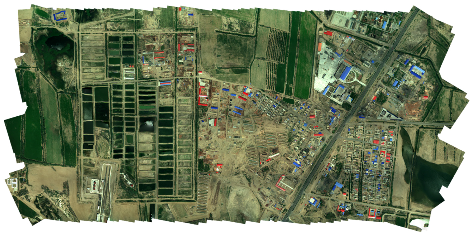
5.2. Mosaicking Results
6. Assessments and Discussion
6.1. Assessment of Processing Efficiency
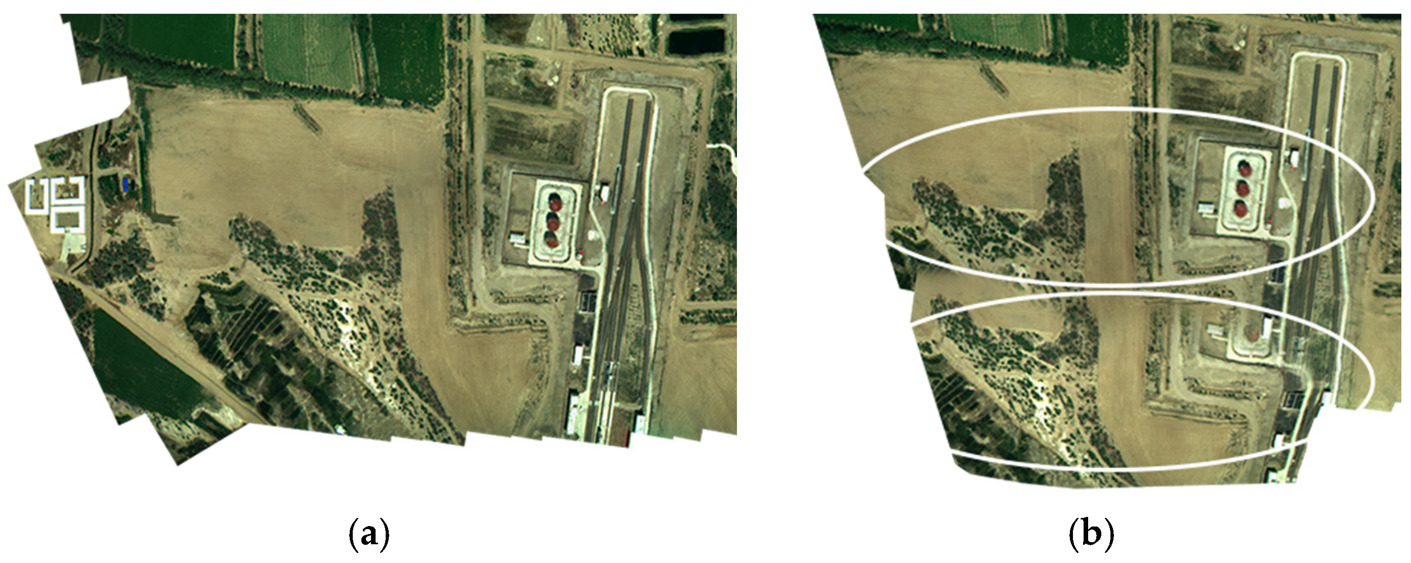
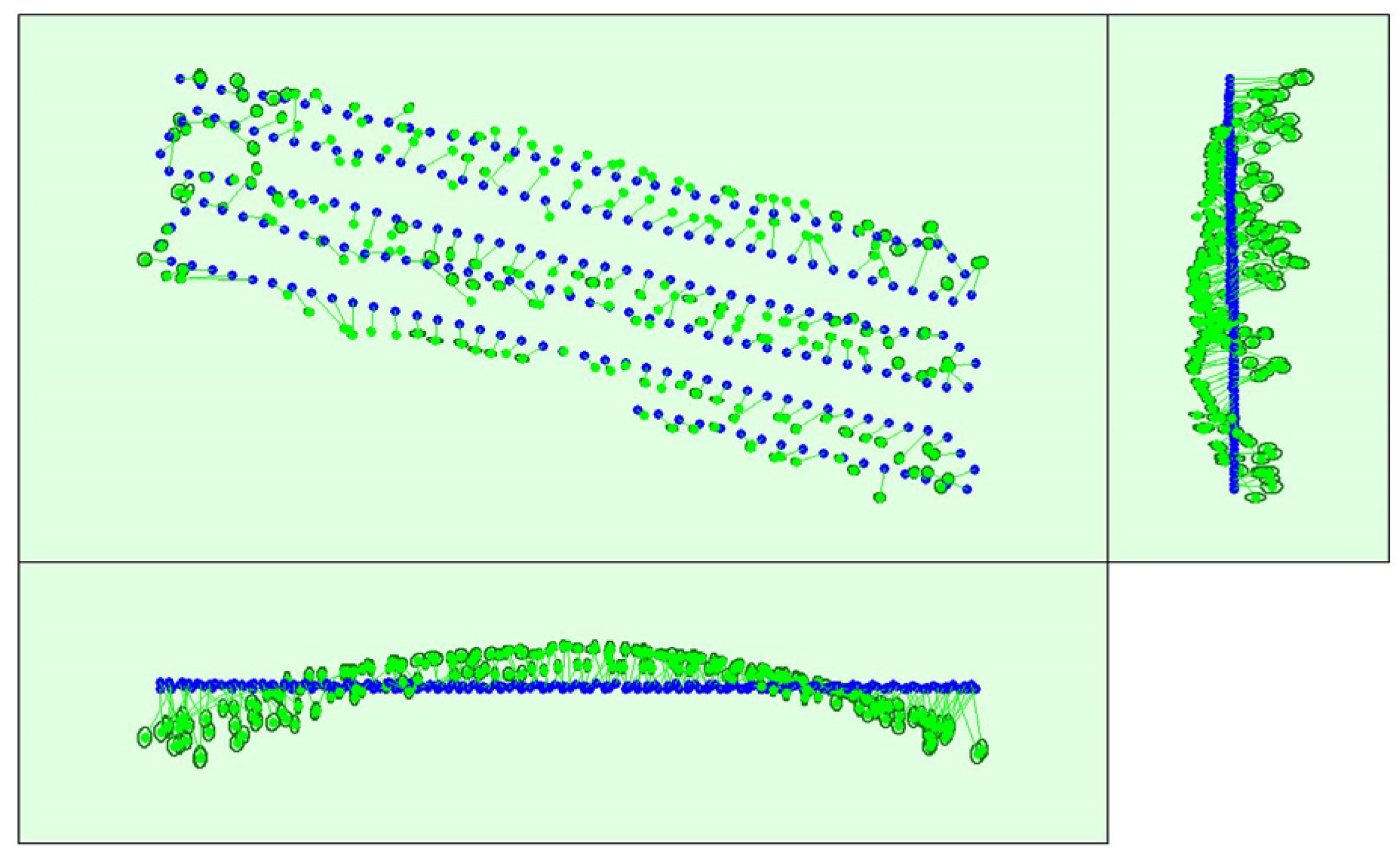
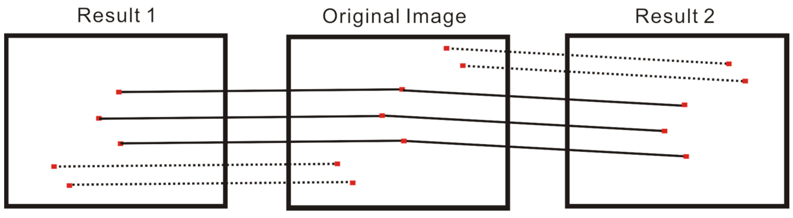
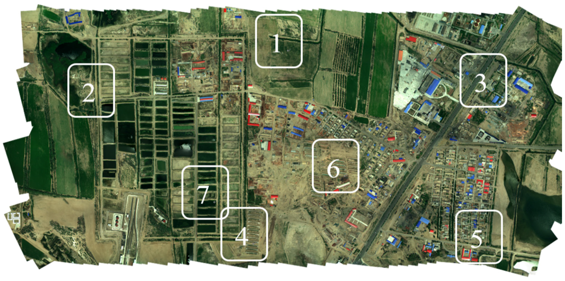
6.2. Accuracy Assessment
6.3. The Impact of Altitude Accuracy
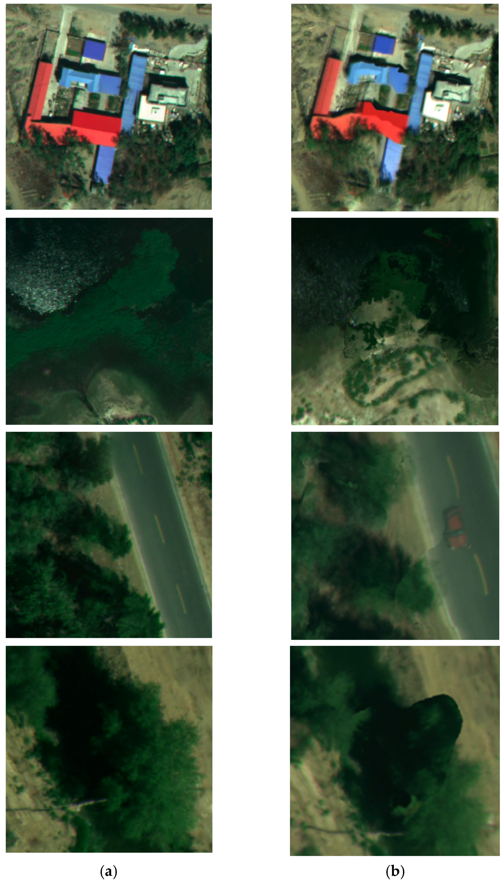
6.4. The Impact of the Alignment of the Bands
6.5. The Impact of the Other Reflection Characteristics of the Ground Targets
7. Conclusions
Acknowledgments
Author Contributions
Conflicts of Interest
References
- Feng, Q.; Liu, J.; Gong, J. UAV remote sensing for urban vegetation mapping using random forest and texture analysis. Remote Sens. 2015, 7, 1074–1094. [Google Scholar] [CrossRef]
- Pajares, G. Overview and current status of remote sensing applications based on unmanned aerial vehicles (UAVs). Photogramm. Eng. Remote Sens. 2015, 81, 281–329. [Google Scholar] [CrossRef]
- Colomina, I.; Molina, P. Unmanned aerial systems for photogrammetry and remote sensing: A review. ISPRS J. Photogramm. Remote Sens. 2014, 92, 79–97. [Google Scholar] [CrossRef]
- Honkavaara, E.; Saari, H.; Kaivosoja, J.; Polonen, I.; Hakala, T.; Litkey, P.; Makynen, J.; Pesonen, L. Processing and assessment of spectrometric, stereoscopic imagery collected using a lightweight UAV spectral camera for precision agriculture. Remote Sens. 2013, 5, 5006–5039. [Google Scholar] [CrossRef] [Green Version]
- Gomez-Candon, D.; De Castro, A.I.; Lopez-Granados, F. Assessing the accuracy of mosaics from unmanned aerial vehicle (UAV) imagery for precision agriculture purposes in wheat. Precis. Agric. 2014, 15, 44–56. [Google Scholar] [CrossRef]
- Sona, G.; Passoni, D.; Pinto, L.; Pagliari, D.; Masseroni, D.; Ortuani, B.; Facchi, A. UAV multispectral survey to map soil and crop for precision farming applications. XXIII ISPRS Congr. Comm. I 2016, 41, 1023–1029. [Google Scholar]
- Nebiker, S.; Annen, A.; Scherrer, M.; Oesch, D. A light-weight multispectral sensor for micro UAV—Opportunities for very high resolution airborne remote sensing. Int. Arch. Photogram. Remote Sens. Spat. Inf. Sci. 2008, 37, 1193–1199. [Google Scholar]
- Turner, D.; Lucieer, A.; Watson, C. An automated technique for generating georectified mosaics from ultra-high resolution unmanned aerial vehicle (UAV) imagery, based on structure from motion (sfm) point clouds. Remote Sens. 2012, 4, 1392–1410. [Google Scholar] [CrossRef]
- Clapuyt, F.; Vanacker, V.; Van Oost, K. Reproducibility of UAV-based earth topography reconstructions based on structure-from-motion algorithms. Geomorphology 2016, 260, 4–15. [Google Scholar] [CrossRef]
- Rau, J.-Y.; Jhan, J.-P.; Li, Y.-T. Development of a large-format uas imaging system with the construction of a one sensor geometry from a multicamera array. IEEE Trans. Geosci. Remote Sens. 2016, 54, 5925–5934. [Google Scholar] [CrossRef]
- Ramirez-Paredes, J.-P.; Lary, D.J.; Gans, N.R. Low-altitude terrestrial spectroscopy from a pushbroom sensor. J. Field Robot. 2016, 33, 837–852. [Google Scholar] [CrossRef]
- Tang, X.; Zhang, G.; Zhu, X.; Pan, H.; Jiang, Y.; Zhou, P.; Wang, X. Triple linear-array image geometry model of ziyuan-3 surveying satellite and its validation. Int. J. Image Data Fusion 2013, 4, 33–51. [Google Scholar] [CrossRef]
- Aguilar, M.A.; Saldana, M.d.M.; Aguilar, F.J. Assessing geometric accuracy of the orthorectification process from geoeye-1 and worldview-2 panchromatic images. Int. J. Appl. Earth Obs. Geoinf. 2013, 21, 427–435. [Google Scholar] [CrossRef]
- Brown, M.; Lowe, D.G. Automatic panoramic image stitching using invariant features. Int. J. Comput. Vis. 2007, 74, 59–73. [Google Scholar] [CrossRef]
- Xu, Y.H.; Ou, J.L.; He, H.; Zhang, X.H.; Mills, J. Mosaicking of unmanned aerial vehicle imagery in the absence of camera poses. Remote Sens. 2016, 8, 16. [Google Scholar] [CrossRef]
- Kim, J.-I.; Kim, T.; Shin, D.; Kim, S. Fast and robust geometric correction for mosaicking UAV images with narrow overlaps. Int. J. Remote Sens. 2017, 38, 2557–2576. [Google Scholar] [CrossRef]
- Gini, R.; Pagliari, D.; Passoni, D.; Pinto, L.; Sona, G.; Dosso, P. UAV photogrammetry: Block triangulation comparisons. UAV-G2013 2013, XL-1/W2, 157–162. [Google Scholar]
- Turner, D.; Lucieer, A.; Malenovsky, Z.; King, D.H.; Robinson, S.A. Spatial co-registration of ultra-high resolution visible, multispectral and thermal images acquired with a micro-UAV over antarctic moss beds. Remote Sens. 2014, 6, 4003–4024. [Google Scholar] [CrossRef]
- Zhu, C.; Leow, W.K. Textured mesh surface reconstruction of large buildings with multi-view stereo. Vis. Comput. 2013, 29, 609–615. [Google Scholar] [CrossRef]
- Lowe, D.G. Distinctive image features from scale-invariant keypoints. Int. J. Comput. Vis. 2004, 60, 91–110. [Google Scholar] [CrossRef]
- Ke, Y.; Sukthankar, R. Pca-Sift: A More Distinctive Representation for Local Image Descriptors; IEEE: Piscataway, NJ, USA, 2004. [Google Scholar]
- Bay, H.; Tuytelaars, T.; Van Gool, L. Surf: Speeded up robust features. Comput. Vis. ECCV 2006 2006, 3951, 404–417. [Google Scholar]
- Rublee, E.; Rabaud, V.; Konolige, K.; Bradski, G.; Ieee. Orb: An efficient alternative to sift or surf. In Proceedings of the 2011 IEEE International Conference on Computer Vision (ICCV), Barcelona, Spain, 6–13 November 2011; pp. 2564–2571. [Google Scholar]
- Mikolajczyk, K.; Schmid, C. A performance evaluation of local descriptors. Pattern Anal. Mach. Intell. IEEE Trans. 2005, 27, 1615–1630. [Google Scholar] [CrossRef] [PubMed]
- Teke, M.; Temizel, A. Multi-spectral satellite image registration using scale-restricted surf. In Proceedings of the 2010 20th International Conference on Pattern Recognition (ICPR 2010), Istanbul, Turkey, 23–26 August 2010; pp. 2310–2313. [Google Scholar]
- Teke, M.; Vural, M.F.; Temizel, A.; Yardimci, Y. High-resolution multispectral satellite image matching using scale invariant feature transform and speeded up robust features. J. Appl. Remote Sens. 2011, 5. [Google Scholar] [CrossRef]
- Navia, J.; Mondragon, I.; Patino, D.; Colorado, J. Multispectral mapping in agriculture: Terrain mosaic using an autonomous quadcopter UAV. In Proceedings of the International Conference on Unmanned Aircraft Systems (ICUAS), Arlington, VA, USA, 7–10 June 2016; pp. 1351–1358. [Google Scholar]
- Lucas, B.D.; Kanade, T. An iterative image registration technique with an application to stereo vision. In Proceedings of the 7th International Joint Conference on Artificial Intelligence, Vancouver, BC, Canada, 24–28 August 1981. [Google Scholar]
- Du, Q.; Raksuntorn, N.; Orduyilmaz, A.; Bruce, L.M. Automatic registration and mosaicking for airborne multispectral image sequences. Photogramm. Eng. Remote Sens. 2008, 74, 169–181. [Google Scholar] [CrossRef]
- Il, K.Y.; Yu-kyung, H.; Dong, H.; Wan, C.J. Mosaic image generation of aisa eagle hyperspectral sensor using sift method. J. Korean Soc. Surv. Geod. Photogramm. Cartogr. 2013, 30, 165–172. [Google Scholar]
- Zhengqi, L.; Isler, V. Large scale image mosaic construction for agricultural applications. IEEE Robot. Autom. Lett. 2016, 1, 295–302. [Google Scholar]
- Li, X.; Yeh, A.G.-O. Analyzing spatial restructuring of land use patterns in a fast growing region using remote sensing and gis. Landsc. Urban Plan. 2004, 69, 335–354. [Google Scholar] [CrossRef]
- Hartley, R.; Zisserman, A. Multiple View Geometry in Computer Vision; Cambridge University Press: Cambridge, UK, 2003; p. 159. [Google Scholar]
- Agarwal, S.; Snavely, N.; Seitz, S.M.; Szeliski, R. Bundle adjustment in the large. In Proceedings of the 11th European Conference on Computer Vision (ECCV 2010), Crete, Greece, 5–11 September 2010; Volume 6312, pp. 29–42. [Google Scholar]
- Ren, X.; Sun, M.; Jiang, C.; Liu, L.; Zheng, H.; Li, X.D. A method of fast mosaic for massive UAV images. In Proceedings of the Conference on Land Surface Remote Sensing II, Beijing, China, 13–16 October 2014; Spie-Int Soc Optical Engineering: Beijing, China, 2014. [Google Scholar]
- Triggs, B.; McLauchlan, P.F.; Hartley, R.I.; Fitzgibbon, A.W. Bundle adjustment-a modern synthesis. Vis. Algorithms Theory Pract. Int. Workshop Vis. Algorithms 2000, 1883, 298–372. [Google Scholar]
- Xiong, Y.L.; Turkowski, K.; Soc, I.C.; Ieee Comp, S.O.C. Registration, calibration and blending in creating high quality panoramas. In Proceedings of the Fourth IEEE Workshop on Applications of Computer Vision—Wacv’98, Princeton, NJ, USA, 19–21 October 1998; pp. 69–74. [Google Scholar]
- Pix4dmapper pro. Available online: https://pix4d.com/product/pix4dmapper/ (accessed on 13 Spetember 2017).
- Pixi4D. How to create and process a tetracam dataset. Available online: https://support.pix4d.com/hc/en-us/articles/202560219-How-to-create-and-process-a-Tetracam-dataset (accessed on 13 Spetember 2017).
- Developers, N. Numpy. Available online: http://www.numpy.org/ (accessed on 13 Spetember 2017).


| Band | Wave Length-Band Width (nm) | Name | Relative Exposure (%) |
|---|---|---|---|
| Band1 | 550-10 | Green | 70 |
| Band2 | 490-10 | Blue | 127 |
| Band3 | 680-10 | Red | 100 |
| Band4 | 720-10 | NIR | 100 |
| Band5 | 800-10 | NIR | 80 |
| Band6 | 900-20 | NIR | 100 |
| Dataset Name | Band1 | Band2 | Band3 | Band4 | Band5 | Band6 |
|---|---|---|---|---|---|---|
| Dataset-urban | 88.931 | 57.232 | 141.191 | 31.346 | 13.180 | 6.365 |
| Dataset-popcorn | 27.063 | 15.183 | 54.798 | 20.561 | 38.970 | 15.472 |
| Band1 | Band2 | Band3 | Band4 | Band5 | Band6 | |
|---|---|---|---|---|---|---|
| Q-Value | 27.063 | 15.183 | 54.798 | 20.561 | 38.970 | 15.472 |
| Matched PointPairs | 29506 | 26703 | 31751 | 20130 | 29288 | 23003 |
| Dataset Size | Proposed Method (Time in S) | Pix4Dmapper (Time in S) |
|---|---|---|
| 147 | 449 | 960 |
| 254 | 1047 | 3720 |
| 362 | 2117 | 11,400 s |
| RMS | Proposed Method (pixel) | Pix4Dmapper (pixel) |
|---|---|---|
| AVERAGE | 12.84 | 38.89 |
| MIN | 4.34 | 14.58 |
| MAX | 23.36 | 80.51 |
| Sample Zone No. | Matched Point Number | RMS Error of Proposed Method | Standard Deviation of RMS Errors (Proposed Method) | RMS Error of Pix4Dmapper | Standard Deviation of RMS Errors (Pix4Dmapper) | Z-Test Value |
|---|---|---|---|---|---|---|
| 1 | 321 | 7.9892 | 4.6523 | 8.8905 | 5.0781 | −2.4201 |
| 2 | 775 | 6.3240 | 3.2269 | 7.8622 | 4.2996 | −7.9659 |
| 3 | 233 | 9.4951 | 5.0966 | 8.8159 | 5.0751 | 1.4414 |
| 4 | 493 | 5.9284 | 3.5761 | 6.8598 | 4.0188 | −3.8441 |
| 5 | 452 | 8.7438 | 5.0430 | 7.8676 | 4.9279 | 2.6420 |
| 6 | 634 | 7.3783 | 3.7951 | 7.7523 | 4.4444 | −1.6114 |
| 7 | 336 | 6.6388 | 3.3675 | 7.6904 | 3.7820 | −3.8064 |
© 2017 by the authors. Licensee MDPI, Basel, Switzerland. This article is an open access article distributed under the terms and conditions of the Creative Commons Attribution (CC BY) license (http://creativecommons.org/licenses/by/4.0/).
Share and Cite
Ren, X.; Sun, M.; Zhang, X.; Liu, L. A Simplified Method for UAV Multispectral Images Mosaicking. Remote Sens. 2017, 9, 962. https://doi.org/10.3390/rs9090962
Ren X, Sun M, Zhang X, Liu L. A Simplified Method for UAV Multispectral Images Mosaicking. Remote Sensing. 2017; 9(9):962. https://doi.org/10.3390/rs9090962
Chicago/Turabian StyleRen, Xiang, Min Sun, Xianfeng Zhang, and Lei Liu. 2017. "A Simplified Method for UAV Multispectral Images Mosaicking" Remote Sensing 9, no. 9: 962. https://doi.org/10.3390/rs9090962
APA StyleRen, X., Sun, M., Zhang, X., & Liu, L. (2017). A Simplified Method for UAV Multispectral Images Mosaicking. Remote Sensing, 9(9), 962. https://doi.org/10.3390/rs9090962