

Sea Surface Currents Estimated from Spaceborne Infrared Images Validated against Reanalysis Data and Drifters in the Mediterranean Sea

Abstract
1. Introduction
2. Data and Methods
2.1. Satellite, Drifter, and Reanalysis Data
2.2. Sea Surface Current Retrieval with the Maximum Cross Correlation Algorithm
- the size of the template, that we here define as a box of 5, 10 (default), or 20 km per side;
- the size of the search window, here defined by setting the maximum velocity that the retrieved field cannot exceed to 1.0 m (default), 1.3 m , or 1.8 m ;
- the maximum cross-correlation threshold, which means that velocity values are returned only if the maximum correlation is larger than 0.3, 0.6 (default), or 0.9.
2.3. Methods for Comparison
- we discard both MCC and drifter points with a speed equal to zero, for which a direction cannot be estimated;
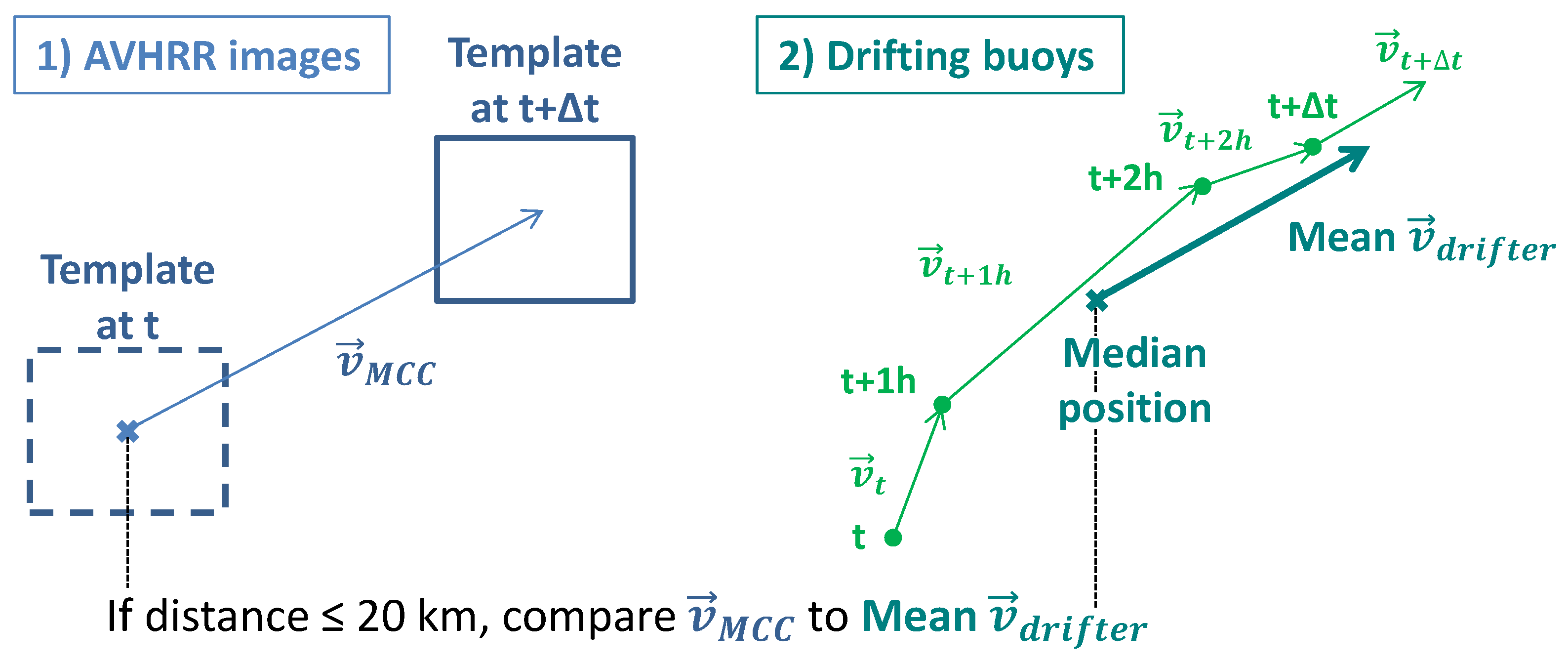
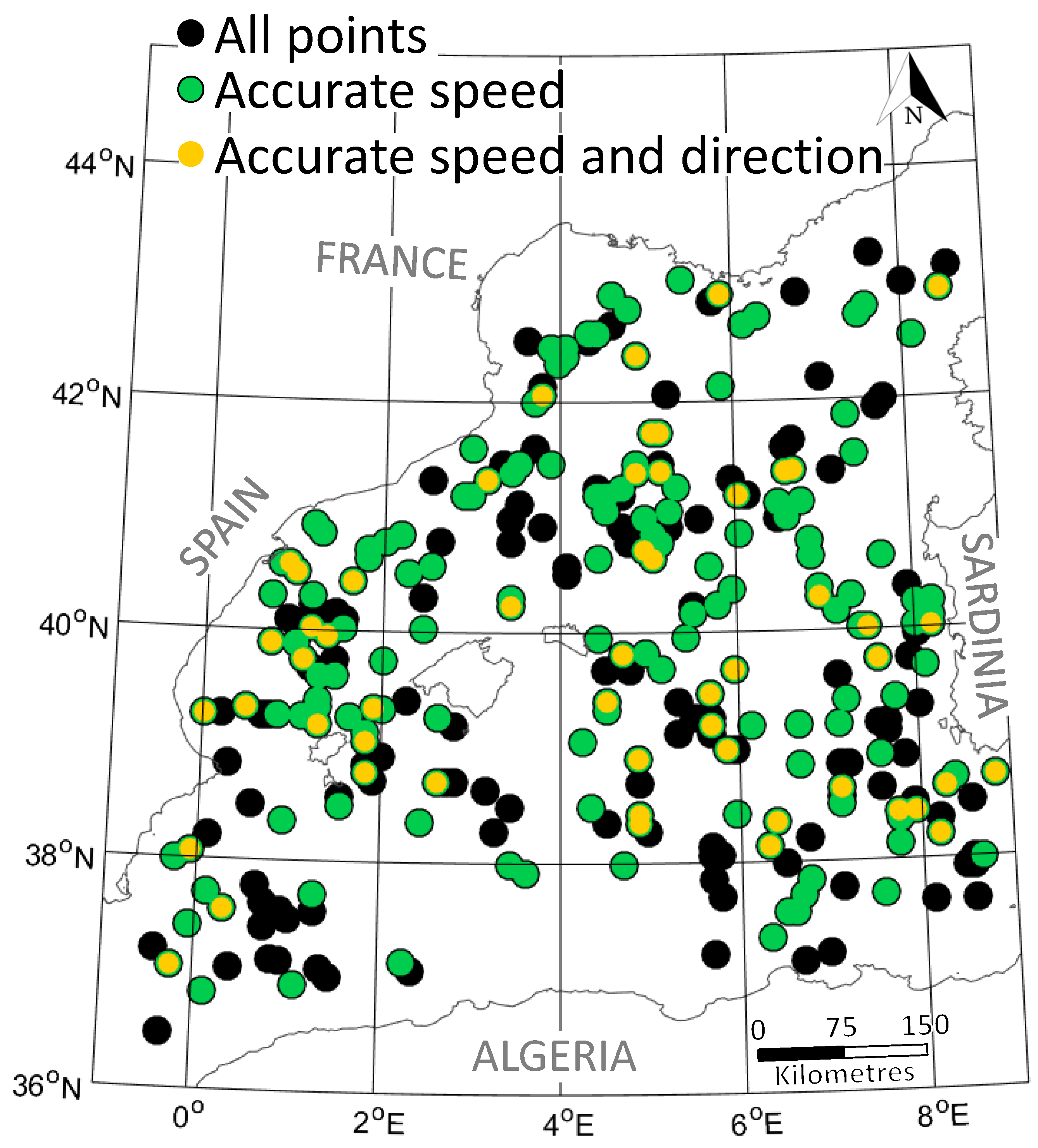
- we discard the MCC points that are further than 20 km away from a drifter (Figure 1). We tested different thresholds between 10 and 50 km, and found that the results were not significantly affected by this choice of threshold;
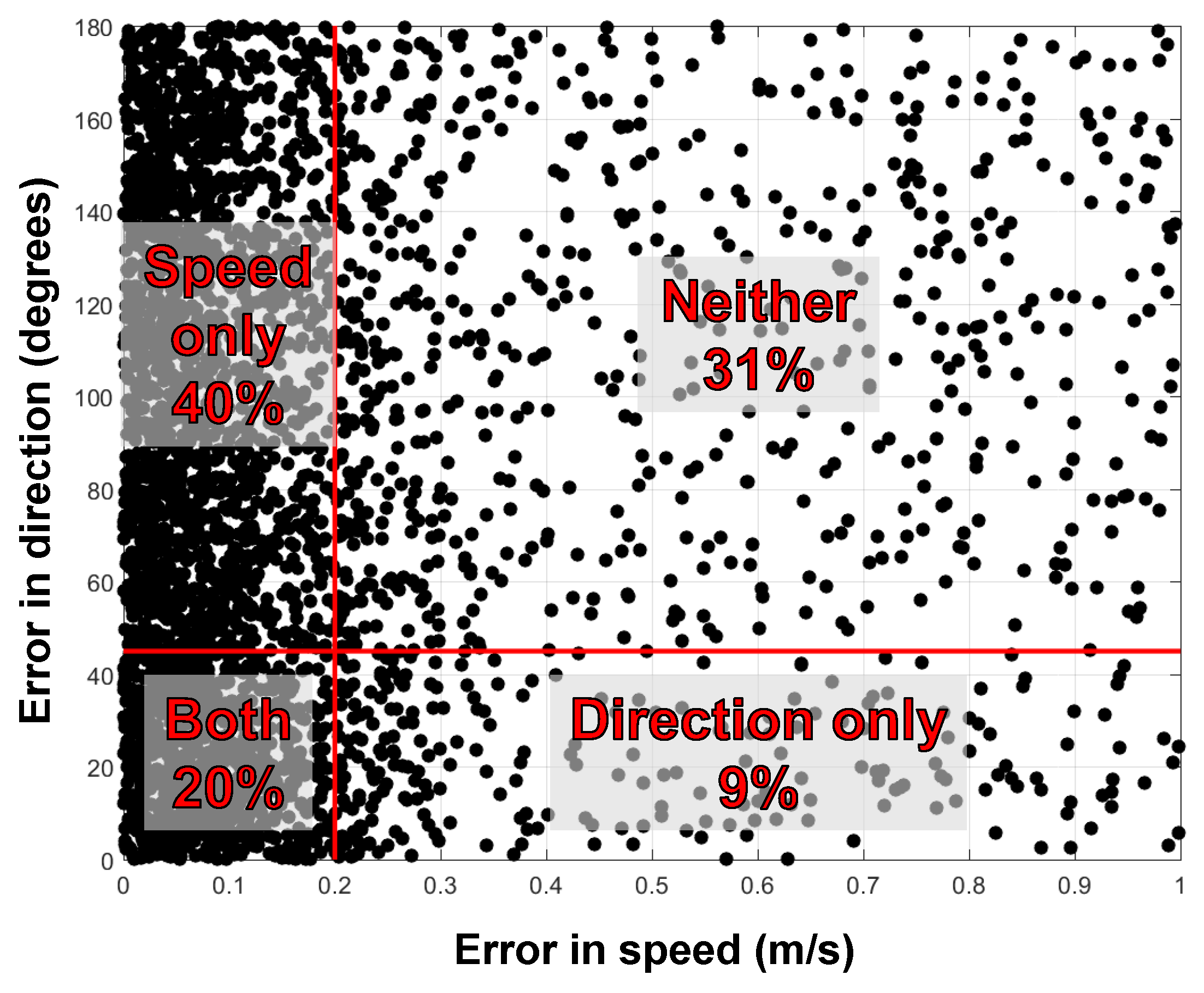
- we discard the MCC points that are within 20 km of each other and whose directions differ by more than . For such points, the uncertainty attached to the MCC result is so high that an agreement with in-situ observation is meaningless (and due to luck).
3. Results and Discussion
3.1. MCC Performance—Sensitivity Experiment
- template window of 10 km by 10 km;
- maximum speed of 1.0 m ;
- correlation threshold R = 0.6;
3.2. MCC Performance—Characteristics of the Images
3.3. MCC and Drifters vs. Reanalysis
4. Summary, Limitations, and Conclusions
- the size of the template window, on the first image;
- the maximum velocity allowed, which determines the size of the search window, on the second image;
- the cutoff threshold in correlation.
Acknowledgments
Author Contributions
Conflicts of Interest
References
- Pisano, A.; De Dominicis, M.; Biamino, W.; Bignami, F.; Gherardi, S.; Colao, F.; Coppini, G.; Marullo, S.; Sprovieri, M.; Trivero, P.; et al. An oceanographic survey for oil spill monitoring and model forecasting validation using remote sensing and in situ data in the Mediterranean Sea. Deep Sea Res. 2016, 133, 132–145. [Google Scholar] [CrossRef] [Scilit]
- Eriksen, M.; Maximenko, N.; Thiel, M.; Cummins, A.; Lattin, G.; Wilson, S.; Hafner, J.; Zellers, A.; Rifman, S. Plastic pollution in the South Pacific subtropical gyre. Mar. Pollut. Bull. 2013, 68, 71–76. [Google Scholar] [CrossRef] [Scilit] [PubMed]
- Klemas, V. Remote Sensing of Coastal and Ocean Currents: An Overview. J. Coast. Res. 2012, 28, 576–586. [Google Scholar] [CrossRef] [Scilit]
- Ronen, D. The effect of oil price on containership speed and fleet size. J. Oper. Res. Soc. 2011, 62, 211–216. [Google Scholar] [CrossRef] [Scilit]
- Paduan, J.; Washburn, L. High-frequency radar observations of ocean surface currents. Annu. Rev. Mar. Sci. 2013, 5, 115–136. [Google Scholar] [CrossRef] [Scilit] [PubMed]
- Hessner, K.; Reichert, K.; Borge, J.; Stevens, C.; Smith, M. High-resolution X-Band radar measurements of currents, bathymetry and sea state in highly inhomogeneous coastal areas. Ocean Dyn. 2014, 64, 989–998. [Google Scholar] [CrossRef] [Scilit]
- Lund, B.; Graber, H.; Hessner, K.; Williams, N. On shipboard marine X-band radar near-surface current “Calibration”. J. Atmos. Ocean. Technol. 2015, 32, 1928–1944. [Google Scholar] [CrossRef] [Scilit]
- Wunsch, C.; Gaposchkin, E. On using satellite altimetry to determine the general circulation of the oceans with application to geoid improvement. Rev. Geophys. 1980, 18, 725–745. [Google Scholar] [CrossRef] [Scilit]
- Emery, W.J.; Thomas, A.C.; Collins, M.J.; Crawford, W.R.; Mackas, D.L. An objective method for computing advective surface velocities from sequential infrared satellite images. J. Geophys. Res. Oceans 1986, 91, 12865–12878. [Google Scholar] [CrossRef] [Scilit]
- Tokmakian, R.; Strub, P.T.; McClean-Padman, J. Evaluation of the maximum cross–correlation method of estimating sea surface velocities from sequential satellite images. J. Atmos. Ocean Technol. 1990, 7, 852–865. [Google Scholar] [CrossRef] [Scilit]
- Warren, M.A.; Quartly, G.D.; Shutler, J.D.; Miller, P.I.; Yoshikawa, Y. Estimation of ocean surface currents from maximum cross correlation applied to GOCI geostationary satellite remote sensing data over the Tsushima (Korea) Straits. J. Geophys. Res. Oceans 2016, 121, 6993–7009. [Google Scholar] [CrossRef] [Scilit]
- Shutler, J.D.; Quartly, G.D.; Donlon, C.J.; Sathyendranath, S.; Platt, T.; Chapron, B.; Johannessen, J.A.; Girard-Ardhuin, F.; Nightingale, P.D.; Woolf, D.K.; et al. Progress in satellite remote sensing for studying physical processes at the ocean surface and its borders with the atmosphere and sea ice. Prog. Phys. Geogr. 2016, 40, 215–246. [Google Scholar] [CrossRef] [Scilit]
- Emery, W.J.; Fowler, C.; Clayson, C.A. Satellite-image-derived Gulf Stream currents compared with numerical model results. J. Atmos. Ocean Technol. 1992, 9, 286–304. [Google Scholar] [CrossRef] [Scilit]
- Bowen, M.M.; Emery, W.J.; Wilkin, J.L.; Tildesly, P.C.; Barton, I.J.; Knewtson, R. Extracting multiyear surface currents from sequential thermal imagery using the maximum cross-correlation technique. J. Atmos. Ocean Technol. 2002, 19, 1665–1676. [Google Scholar] [CrossRef] [Scilit]
- Wahl, D.D.; Simpson, J.J. Physical processes affecting the objective determination of near surface velocity from satellite data. J. Geophys. Res. Oceans 1990, 95, 13511–13528. [Google Scholar] [CrossRef] [Scilit]
- Heuzé, C.; Carvajal, G.K.; Eriksson, L.E.B. Optimisation of sea surface current retrieval using a maximum cross correlation technique on modelled sea surface temperature. J. Atmos. Ocean Technol. 2017. submitted. [Google Scholar]
- Doronzo, B.; Taddei, S.; Brandini, C.; Fattorini, M. Extensive analysis of potentialities and limitations of a maximum cross-correlation technique for surface circulation by using realistic ocean model simulations. Ocean Dyn. 2015, 65, 1183–1198. [Google Scholar] [CrossRef] [Scilit]
- Holloway, G.; Nguyen, A.; Wang, Z. Oceans and ocean models as seen by current meters. J. Geophys. Res. Oceans 2011, 116, C00D08. [Google Scholar] [CrossRef] [Scilit]
- Millot, C. Circulation in the western Mediterranean Sea. J. Mar. Sys. 1999, 20, 423–442. [Google Scholar] [CrossRef] [Scilit]
- Isern-Fontanet, J.; García-Ladona, E.; Font, J. Vortices of the Mediterranean Sea: An altimetric perspective. J. Phys. Ocean. 2006, 36, 87–103. [Google Scholar] [CrossRef] [Scilit]
- Pinardi, N.; Masetti, E. Variability of the large scale general circulation of the Mediterranean Sea from observations and modelling: A review. Palaeogeogr. Palaeoclimatol. Palaeoecol. 2000, 158, 153–173. [Google Scholar] [CrossRef] [Scilit]
- Madec, G. NEMO Ocean General Circulation Model Reference Manuel; Technical Report; LODYC/IPSL: Paris, France, 2008. [Google Scholar]
- Tolman, H.L. User Manual and System Documentation of WAVEWATCH III TM Version 3.14; Technical Report, MMAB Contribution 276; MMAB: College Park, MD, USA, 2009. [Google Scholar]
- Lecci, R.; Drudi, M.; Grandi, A.; Fratianni, C. PRODUCT USER MANUAL for Mediterranean Sea Physical Analysis and Forecasting Product MEDSEA_ANALYSIS_FORECAST_PHYS_006_001; EU Copernicus Marine Environment Monitoring Service: Vincennes, France, 2016. [Google Scholar]
- Wessel, P.; Smith, W. A global, self-consistent, hierarchical, high-resolution shoreline database. J. Geophys. Res. B Solid Earth 1996, 101, 8741–8743. [Google Scholar] [CrossRef] [Scilit]
- Matthews, D.K.; Emery, W.J. Velocity observations of the California Current derived from satellite imagery. J. Geophys. Res. Oceans 2009, 114, 2156–2202. [Google Scholar] [CrossRef] [Scilit]
- Chubb, S.R.; Mied, R.P.; Shen, C.Y.; Chen, W.; Evans, T.E.; Kohut, J. Ocean surface currents from AVHRR imagery: Comparison with land-based HF radar measurements. IEEE Trans. Geosci. Remote Sens. 2008, 46, 3647–3660. [Google Scholar] [CrossRef]
- Longuet-Higgins, M.S. On the transport of mass by time–varying ocean currents. Deep Sea Res. 1969, 16, 431–447. [Google Scholar] [CrossRef] [Scilit]
- Qazi, W.A.; Emery, W.J.; Fox-Kemper, B. Computing Ocean Surface Currents Over the Coastal California Current System Using 30–Min–Lag Sequential SAR Images. IEEE Trans. Geosci. Remote Sens. 2014, 52, 7559–7580. [Google Scholar] [CrossRef] [Scilit]
- Flato, G.; Marotzke, J.; Abiodun, B.; Braconnot, P.; Chou, S.C.; Collins, W.J.; Cox, P.; Driouech, F.; Emori, S.; Eyring, V.; et al. Evaluation of Climate Models. In Climate Change 2013: The Physical Science Basis. Contribution of Working Group I to the Fifth Assessment Report of the Intergovernmental Panel on Climate Change; Cambridge University Press: Cambridge, UK; New York, NY, USA, 2013. [Google Scholar]


| Template Size | 10 km | 5 km | 20 km | 10 km | 10 km | 10 km | 10 km |
| Maximum Velocity | 1.0 m | 1.0 m | 1.0 m | 1.3 m | 1.8 m | 1.0 m | 1.0 m |
| Correlation | R = 0.6 | R = 0.6 | R = 0.6 | R = 0.6 | R = 0.6 | R = 0.3 | R = 0.9 |
| Speed Only | 56% | 63% | 45% | 45% | 40% | 51% | 53% |
| Direction Only | 28% | 23% | 29% | 28% | 30% | 32% | 24% |
| Speed and Direction | 16% | 12% | 13% | 14% | 11% | 17% | 12% |
| Total Points | 351 | 293 | 176 | 353 | 359 | 317 | 337 |
| MCC-drifter | MCC-Reanalysis | Drifter-Reanalysis | ||
|---|---|---|---|---|
| Speed | mean | m | 0.08 m | 0.31 m |
| RMSE | 0.51 m | 0.19 m | 1.09 m | |
| Direction | mean | |||
| RMSE |
© 2017 by the authors. Licensee MDPI, Basel, Switzerland. This article is an open access article distributed under the terms and conditions of the Creative Commons Attribution (CC BY) license (http://creativecommons.org/licenses/by/4.0/).
Share and Cite
Heuzé, C.; Carvajal, G.K.; Eriksson, L.E.B.; Soja-Woźniak, M. Sea Surface Currents Estimated from Spaceborne Infrared Images Validated against Reanalysis Data and Drifters in the Mediterranean Sea. Remote Sens. 2017, 9, 422. https://doi.org/10.3390/rs9050422
Heuzé C, Carvajal GK, Eriksson LEB, Soja-Woźniak M. Sea Surface Currents Estimated from Spaceborne Infrared Images Validated against Reanalysis Data and Drifters in the Mediterranean Sea. Remote Sensing. 2017; 9(5):422. https://doi.org/10.3390/rs9050422
Chicago/Turabian StyleHeuzé, Céline, Gisela K. Carvajal, Leif E. B. Eriksson, and Monika Soja-Woźniak. 2017. "Sea Surface Currents Estimated from Spaceborne Infrared Images Validated against Reanalysis Data and Drifters in the Mediterranean Sea" Remote Sensing 9, no. 5: 422. https://doi.org/10.3390/rs9050422
APA StyleHeuzé, C., Carvajal, G. K., Eriksson, L. E. B., & Soja-Woźniak, M. (2017). Sea Surface Currents Estimated from Spaceborne Infrared Images Validated against Reanalysis Data and Drifters in the Mediterranean Sea. Remote Sensing, 9(5), 422. https://doi.org/10.3390/rs9050422