Performance of Three MODIS Fire Products (MCD45A1, MCD64A1, MCD14ML), and ESA Fire_CCI in a Mountainous Area of Northwest Yunnan, China, Characterized by Frequent Small Fires


Abstract
:
1. Introduction
2. Data and Methodology
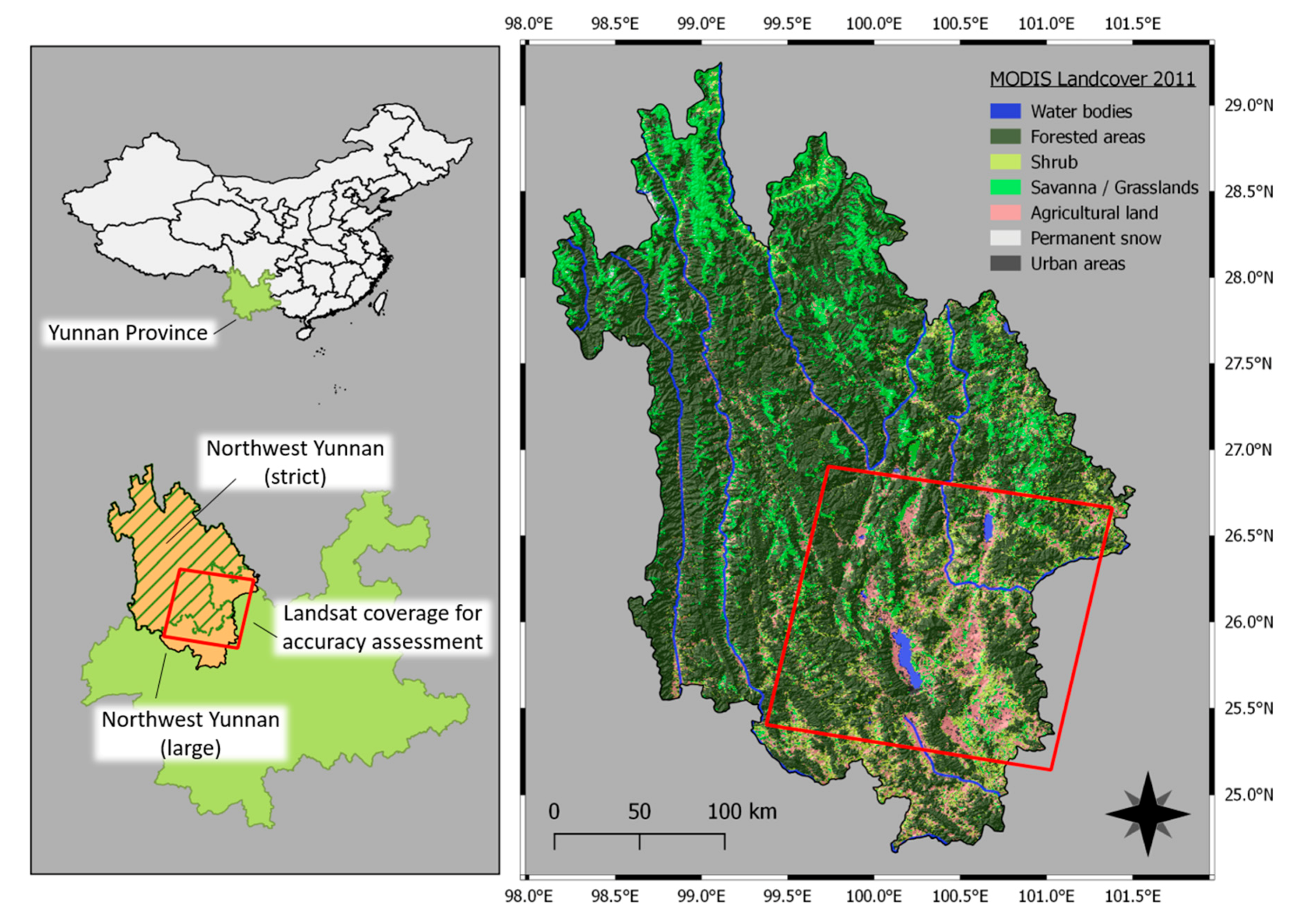
2.1. Description of Study Site
2.2. Data Processing
2.2.1 MODIS Burned Area Collection 5.1 (MCD45A1)
- Spatial rule: pixels should be directly adjacent to each other or within a maximum distance of 1 pixel. We chose a 1 pixel buffer to minimize inaccuracies due to the coarse spatial resolution of the sensor, such as partially burned pixels that remain undetected.
- Temporal rule: pixels should have burning dates within a maximum temporal distance of 16 days. This rule is based on the 8-days precision interval before and after the date of detection proper to the product’s algorithm.
2.2.2. MODIS Active Fire Collection 6 (MCD14ML)
2.2.3. MODIS Direct Broadcast Burned Area Collection 6 (MCD64A1)
2.2.4. ESA’s Fire_CCI
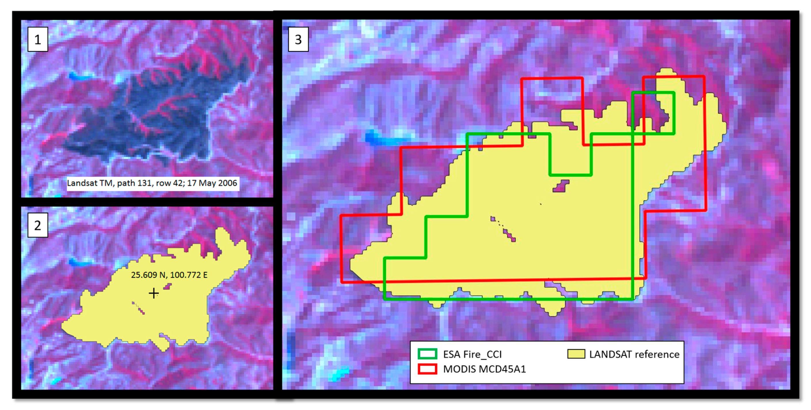
2.2.5. Landsat Reference Dataset
2.3. Accuracy Assessment
3. Results
4. Discussion
5. Conclusions
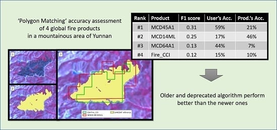
- The analyzed global AF and BA products shows poorer results in our mountainous area than in other ecosystems, mainly due to the smaller size of fires. For burned areas bigger than 50 ha, the best product could detect more than 60% of the fire events. Detection decreases drastically for smaller burned areas.
- The two former MODIS fire products, first MCD45A1 then MCD14ML, were the best performers in our study area, followed by MCD64A1 and Fire_CCI. These results did not align with our expectations. The newest algorithms are designed using hybrid approaches that combine the capabilities of both AF and BA methods. Therefore, among other improvements, they should have performed better in the detection of small fires. On the contrary, they obtained lower scores and higher commission and omission errors than their predecessors. This has important implications for the design of future algorithms. MCD45A1 being the best performer suggests that its bi-directional reflectance based approach is still valid and deserves more consideration, for example, by being integrated in a hybrid approach. Unfortunately, MCD45A1 has been discontinued since January 2017 and replaced by the hybrid MCD64A1, which produced worse results.
- At present, the usefulness of the existing global BA and AF products for the quantification of small fires is still marginal. The spatial resolution limitation of the sensors that are used to generate these datasets represents a physical limit that cannot be passed. Yet, taking into account the high rate of omission and commission, MCD45A1 and MCD14ML’s data can be used to obtain preliminary insights on the fire activity of regions that are characterized by relatively small fires or to partially assess the accuracy of other burned area extraction methods.
Acknowledgments
Author Contributions
Conflicts of Interest
References
- Pausas, J.G.; Keeley, J.E. A burning story: The role of fire in the history of life. Bioscience 2009, 59, 593–601. [Google Scholar] [CrossRef] [Green Version]
- Bond, W.J.; Keeley, J.E. Fire as a global “herbivore”: The ecology and evolution of flammable ecosystems. Trends Ecol. Evol. 2005, 20, 387–394. [Google Scholar] [CrossRef] [PubMed]
- Pyne, S.J.; Andrews, P.L.; Laven, R.D. Introduction to Wildland Fire, 2nd ed.; John Wiley & Sons: New York, NY, USA, 1996; ISBN 978-0471549130. [Google Scholar]
- Bond, W.J.; Woodward, F.I.; Midgley, G.F. The global distribtuion of ecosystems in a world without fire. New Phytol. 2005, 165, 525–538. [Google Scholar] [CrossRef] [PubMed]
- Bowman, D.M.J.S.; Balch, J.K.; Artaxo, P.; Bond, W.J.; Carlson, J.M.; Cochrane, M.A.; Antonio, C.M.D.; Defries, R.S.; Doyle, J.C.; Harrison, S.P.; et al. Fire in the Earth System. Science 2010, 324, 481–484. [Google Scholar] [CrossRef] [PubMed]
- Krebs, P.; Pezzatti, G.B.; Mazzoleni, S.; Talbot, L.M.; Conedera, M. Fire regime: History and definition of a key concept in disturbance ecology. Theory Biosci. 2010, 129, 53–69. [Google Scholar] [CrossRef] [PubMed]
- Summers, W.T.; Coloff, S.G.; Conard, S.G. Synthesis of Knowledge: Fire History and Climate Change; Joint Fire Science Program Project: Boise, ID, USA, 2011; Available online: digitalcommons.unl.edu/cgi/viewcontent.cgi?article=1018&context=jfspsynthesis (accessed on 6 November 2017).
- Yan, X.; Ohara, T.; Akimoto, H. Bottom-up estimate of biomass burning in mainland China. Atmos. Environ. 2006, 40, 5262–5273. [Google Scholar] [CrossRef]
- Mouillot, F.; Schultz, M.G.; Yue, C.; Cadule, P.; Tansey, K.; Ciais, P.; Chuvieco, E. Ten years of global burned area products from spaceborne remote sensing—A review: Analysis of user needs and recommendations for future developments. Int. J. Appl. Earth Obs. Geoinf. 2014, 26, 64–79. [Google Scholar] [CrossRef]
- Tian, X.; Mcrae, D.J.; Shu, L.; Wang, M.; Li, H. Satellite remote-sensing technologies used in forest fire management. J. For. Res. 2005, 16, 73–78. [Google Scholar] [CrossRef]
- Zhang, J.H.; Yao, F.M.; Liu, C.; Yang, L.M.; Boken, V.K. Detection, emission estimation and risk prediction of forest fires in China using satellite sensors and simulation models in the past three decades—An overview. Int. J. Environ. Res. Public Health 2011, 8, 3156–3178. [Google Scholar] [CrossRef] [PubMed]
- Justice, C.O.; Giglio, L.; Korontzi, S.; Owens, J.; Morisette, J.T.; Roy, D.; Descloitres, J.; Alleaume, S.; Petitcolin, F.; Kaufman, Y. The MODIS fire products. Remote Sens. Environ. 2002, 83, 244–262. [Google Scholar] [CrossRef]
- Roy, D.P.; Boschetti, L.; Justice, C.O.; Ju, J. The collection 5 MODIS burned area product—Global evaluation by comparison with the MODIS active fire product. Remote Sens. Environ. 2008, 112, 3690–3707. [Google Scholar] [CrossRef]
- Giglio, L. Characterization of the tropical diurnal fire cycle using VIRS and MODIS observations. Remote Sens. Environ. 2007, 108, 407–421. [Google Scholar] [CrossRef]
- Arino, O.; Casadio, S.; Serpe, D. Global night-time fire season timing and fire count trends using the ATSR instrument series. Remote Sens. Environ. 2012, 116, 226–238. [Google Scholar] [CrossRef]
- Giglio, L.; Descloitres, J.; Justice, C.O.; Kaufman, Y.J. An enhanced contextual fire detection algorithm for MODIS. Remote Sens. Environ. 2003, 87, 273–282. [Google Scholar] [CrossRef]
- Giglio, L.; Schroeder, W.; Justice, C.O. The collection 6 MODIS active fire detection algorithm and fire products. Remote Sens. Environ. 2016, 178, 31–41. [Google Scholar] [CrossRef]
- Simon, M.; Plummer, S.; Fierens, F.; Hoelzemann, J.J.; Arino, O. Burnt area detection at global scale using ATSR-2: The GLOBSCAR products and their qualification. J. Geophys. Res. D Atmos. 2004, 109, 1–16. [Google Scholar] [CrossRef]
- Tansey, K. Vegetation burning in the year 2000: Global burned area estimates from SPOT VEGETATION data. J. Geophys. Res. 2004, 109, D14S03. [Google Scholar] [CrossRef]
- Tansey, K.; Grégoire, J.-M.; Defourny, P.; Leigh, R.; Pekel, J.-F.; van Bogaert, E.; Bartholomé, E. A new, global, multi-annual (2000–2007) burnt area product at 1 km resolution. Geophys. Res. Lett. 2008, 35, 1–6. [Google Scholar] [CrossRef]
- Plummer, S.; Arino, O.; Ranera, F.; Tansey, K.; Chen, J.; Dedieu, G.; Eva, H.; Piccolini, I.; Leigh, R.; Borstlap, G.; et al. An update on the globcarbon initiative: Multi-sensor estimation of global biophysical products for global terrestrial carbon studies. In Proceedings of the Envisat Symposium, Montreux, Switzerland, 23–27 April 2007; Available online: envisat.esa.int/workshops/envisatsymposium/proceedings/sessions/2S2/460668pl.pdf (accessed on 2 November 2017).
- Plummer, S.; Arino, O.; Simon, M.; Steffen, W. Establishing a earth observation product service for the terrestrial carbon community: The globcarbon initiative. Mitig. Adapt. Strateg. Glob. Chang. 2006, 11, 97–111. [Google Scholar] [CrossRef]
- Alonso-Canas, I.; Chuvieco, E. Global burned area mapping from ENVISAT-MERIS and MODIS active fire data. Remote Sens. Environ. 2015, 163, 140–152. [Google Scholar] [CrossRef]
- Roy, D.P.; Jin, Y.; Lewis, P.E.; Justice, C.O. Prototyping a global algorithm for systematic fire-affected area mapping using MODIS time series data. Remote Sens. Environ. 2005, 97, 137–162. [Google Scholar] [CrossRef]
- Giglio, L.; Loboda, T.; Roy, D.P.; Quayle, B.; Justice, C.O. An active-fire based burned area mapping algorithm for the MODIS sensor. Remote Sens. Environ. 2009, 113, 408–420. [Google Scholar] [CrossRef]
- Giglio, L.; Randerson, J.T.; van der Werf, G.R. Analysis of daily, monthly, and annual burned area using the fourth-generation global fire emissions database (GFED4). J. Geophys. Res. Biogeosci. 2013, 118, 317–328. [Google Scholar] [CrossRef]
- Giglio, L.; Randerson, J.T.; van der Werf, G.R.; Kasibhatla, P.S.; Collatz, G.J.; Morton, D.C.; DeFries, R.S. Assessing variability and long-term trends in burned area by merging multiple satellite fire products. Biogeosciences 2010, 7, 1171–1186. [Google Scholar] [CrossRef] [Green Version]
- Padilla, M.; Stehman, S.V.; Ramo, R.; Corti, D.; Hantson, S.; Oliva, P.; Alonso-Canas, I.; Bradley, A.V.; Tansey, K.; Mota, B.; et al. Comparing the accuracies of remote sensing global burned area products using stratified random sampling and estimation. Remote Sens. Environ. 2015, 160, 114–121. [Google Scholar] [CrossRef]
- Tsela, P.; Wessels, K.; Botai, J.; Archibald, S.; Swanepoel, D.; Steenkamp, K.; Frost, P. Validation of the two standard MODIS satellite burned-area products and an empirically-derived merged product in South Africa. Remote Sens. 2014, 6, 1275–1293. [Google Scholar] [CrossRef]
- Van Der Werf, G.R.; Randerson, J.T.; Giglio, L.; Collatz, G.J.; Mu, M.; Kasibhatla, P.S.; Morton, D.C.; Defries, R.S.; Jin, Y.; Van Leeuwen, T.T. Global fire emissions and the contribution of deforestation, savanna, forest, agricultural, and peat fires (1997–2009). Atmos. Chem. Phys. 2010, 10, 11707–11735. [Google Scholar] [CrossRef] [Green Version]
- Van der Werf, G.R.; Randerson, J.T.; Giglio, L.; Collatz, G.J.; Kasibhatla, P.S.; Arellano, A.F. Interannual variability in global biomass burning emissions from 1997 to 2004. Atmos. Chem. Phys. 2006, 6, 3423–3441. [Google Scholar] [CrossRef] [Green Version]
- Randerson, J.T.; Chen, Y.; Van Der Werf, G.R.; Rogers, B.M.; Morton, D.C. Global burned area and biomass burning emissions from small fires. J. Geophys. Res. Biogeosci. 2012, 117, 1–23. [Google Scholar] [CrossRef]
- Chuvieco, E.; Yue, C.; Heil, A.; Mouillot, F.; Alonso-Canas, I.; Padilla, M.; Pereira, J.M.; Oom, D.; Tansey, K. A new global burned area product for climate assessment of fire impacts. Glob. Ecol. Biogeogr. 2016, 25, 619–629. [Google Scholar] [CrossRef]
- Boschetti, L.; Eva, H.D.; Brivio, P.A.; Grégoire, J.M. Lessons to be learned from the comparison of three satellite-derived biomass burning products. Geophys. Res. Lett. 2004, 31, 2–5. [Google Scholar] [CrossRef]
- Núñez-Casillas, L.; García Lázaro, J.R.; Moreno-Ruiz, J.A.; Arbelo, M. A Comparative Analysis of Burned Area Datasets in Canadian Boreal Forest in 2000. Sci. World J. 2013, 2013, 289056. [Google Scholar] [CrossRef] [PubMed]
- Freeborn, P.; Cochrane, M.; Wooster, M. A Decade Long, Multi-Scale Map Comparison of Fire Regime Parameters Derived from Three Publically Available Satellite-Based Fire Products: A Case Study in the Central African Republic. Remote Sens. 2014, 6, 4061–4089. [Google Scholar] [CrossRef]
- Schroeder, W.; Prins, E.; Giglio, L.; Csiszar, I.; Schmidt, C.; Morisette, J.; Morton, D. Validation of GOES and MODIS active fire detection products using ASTER and ETM+ data. Remote Sens. Environ. 2008, 112, 2711–2726. [Google Scholar] [CrossRef]
- Bastarrika, A.; Chuvieco, E.; Martin, M.P. Automatic burned land mapping from MODIS time series images: Assessment in Mediterranean ecosystems. IEEE Trans. Geosci. Remote Sens. 2011, 49, 3401–3413. [Google Scholar] [CrossRef]
- Chuvieco, E.; Englefield, P.; Trishchenko, A.P.; Luo, Y. Generation of long time series of burn area maps of the boreal forest from NOAA-AVHRR composite data. Remote Sens. Environ. 2008, 112, 2381–2396. [Google Scholar] [CrossRef]
- Merino-de-Miguel, S.; Huesca, M.; González-Alonso, F. Modis reflectance and active fire data for burn mapping and assessment at regional level. Ecol. Modell. 2010, 221, 67–74. [Google Scholar] [CrossRef]
- Fraser, R.H.; Li, Z.; Cihlar, J. Hotspot and NDVI Differencing Synergy (HANDS)-A New Technique for Burned Area Mapping over Boreal Forest. Remote Sens. Environ. 2000, 74, 362–376. [Google Scholar] [CrossRef]
- Urbanski, S.P.; Salmon, J.M.; Nordgren, B.L.; Hao, W.M. A MODIS direct broadcast algorithm for mapping wildfire burned area in the western United States. Remote Sens. Environ. 2009, 113, 2511–2526. [Google Scholar] [CrossRef]
- Chuvieco, E.; Opazo, S.; Sione, W.; Valle, H.; Anaya, J.; Bella, D.; Cruz, I.; Manzo, L.; López, G.; Mari, N.; et al. Global Burned-Land Estimation in Latin America Using Modis Composite Data. Ecol. Appl. 2008, 18, 64–79. [Google Scholar] [CrossRef] [PubMed]
- Yang, W.; Zhang, S.; Tang, J.; Bu, K.; Yang, J.; Chang, L. A MODIS time series data based algorithm for mapping forest fire burned area. Chin. Geogr. Sci. 2013, 23, 344–352. [Google Scholar] [CrossRef]
- Csiszar, I.A.; Morisette, J.T.; Giglio, L. Validation of active fire detection from moderate-resolution satellite sensors: The MODIS example in Northern Eurasia. IEEE Trans. Geosci. Remote Sens. 2006, 44, 1757–1764. [Google Scholar] [CrossRef]
- Roy, D.P.; Frost, P.G.H.; Justice, C.O.; Landmann, T.; Le Roux, J.L.; Gumbo, K.; Makungwa, S.; Dunham, K.; Du Toit, R.; Mhwandagara, K.; et al. The Southern Africa Fire Network (SAFNet) regional burned-area product-validation protocol. Int. J. Remote Sens. 2005, 26, 4265–4292. [Google Scholar] [CrossRef]
- De Araújo, F.M.; Ferreira, L.G. Satellite-based automated burned area detection: A performance assessment of the MODIS MCD45A1 in the Brazilian savanna. Int. J. Appl. Earth Obs. Geoinf. 2015, 36, 94–102. [Google Scholar] [CrossRef]
- Roy, D.P.; Boschetti, L. Southern Africa validation of the MODIS, L3JRC, and GlobCarbon burned-area products. IEEE Trans. Geosci. Remote Sens. 2009, 47, 1032–1044. [Google Scholar] [CrossRef]
- Anaya, J.A.; Chuvieco, E. Accuracy assessment of burned area products in the orinoco basin. Photogramm. Eng. Remote Sens. 2012, 78, 53–60. [Google Scholar] [CrossRef]
- Weiss, D.J.; Walsh, S.J. Remote Sensing of Mountain Environments. Geogr. Compass 2009, 3, 1–21. [Google Scholar] [CrossRef]
- Heinimann, A.; Breu, T.; Kohler, T. The challenge of applying Geographic Information Systems to sustainable mountain development. Mt. Res. Dev. 2003, 23, 312–319. [Google Scholar] [CrossRef]
- Grêt-Regamey, A.; Brunner, S.H.; Kienast, F. Mountain Ecosystem Services: Who Cares? Mt. Res. Dev. 2012, 32, S23–S34. [Google Scholar] [CrossRef]
- Mittermeier, R.A.; Myers, N.; Thomsen, J.B.; da Fonseca, G.A.B.; Olivieri, S. Biodiversity Hotspots and Major Tropical Wilderness Areas: Approaches to Setting Conservation Priorities. Conserv. Biol. 1998, 12, 516–520. [Google Scholar] [CrossRef]
- Mackinnon, J.R.; Carey, G. A Biodiversity Review of China; World Wide Fund for Nature (WWF) International, WWF China Programme: Beijing, China, 1996. [Google Scholar]
- Xiao, W.; Ding, W.; Cui, L.W.; Zhou, R.L.; Zhao, Q.K. Habitat degradation of Rhinopithecus bieti in Yunnan, China. Int. J. Primatol. 2003, 24, 389–398. [Google Scholar] [CrossRef]
- Li, J.; Song, Y.; Huang, X.; Li, M. Comparison of forest burned areas in mainland China derived from MCD45A1 and data recorded in yearbooks from 2001 to 2011. Int. J. Wildl. Fire 2014, 24, 103–113. [Google Scholar] [CrossRef]
- Xu, J.; Wilkes, A. Biodiversity impact analysis in northwest Yunnan, southwest China. Biodivers. Conserv. 2004, 13, 959–983. [Google Scholar] [CrossRef]
- Qin, X.; Li, Z.; Zhang, Z. Distribution Pattern of Fires in China Based on Satellite Data. In Proceedings of the 2010 Second lITA International Conference on Geoscience and Remote Sensing, Qingdao, China, 28–31 August 2010; pp. 503–506. [Google Scholar]
- Li, X.; Zhao, G.; Yu, X.; Yu, Q. A comparison of forest fire indices for predicting fire risk in contrasting climates in China. Nat. Hazards 2014, 70, 1339–1356. [Google Scholar] [CrossRef]
- Lü, A.; Tian, H.; Liu, M.; Liu, J.; Melillo, J.M. Spatial and temporal patterns of carbon emissions from forest fires in China from 1950 to 2000. J. Geophys. Res. 2006, 111, 1–12. [Google Scholar] [CrossRef]
- Shu, L.; Tian, X.; Wang, M. A Study on Forest Fire Occurrence in China. In Proceedings of the XII World Forestry Congress, Quebec City, QC, Canada, 21–23 September 2003; Available online: http://www.fao.org/docrep/ARTICLE/WFC/XII/0278-B1.HTM (accessed on 2 November 2017).
- Zhao, F.; Shu, L.; Tian, X.; Wang, M. Change trends of forest fire danger in Yunnan province in 1957–2007. Chin. J. Ecol. 2009, 28, 2333–2338. [Google Scholar]
- Tian, X.; Zhao, F.; Shu, L.; Wang, M. Changes in forest fire danger for south-western China in the 21st century. Int. J. Wildl. Fire 2014, 23, 185–195. [Google Scholar] [CrossRef]
- Tang, C.Q. Subtropical montane evergreen broad-leaved forests of Yunnan, China: Diversity, succession dynamics, human influence. Front. Earth Sci. China 2010, 4, 22–32. [Google Scholar] [CrossRef]
- Wang, C.; He, Z.; Zhu, W. Ouline of vegetation in Dulongjiang river watershed, Yunnan. Chin. J. Ecol. 2001, 20, 26–33. [Google Scholar]
- Ming, Q.; Shi, Z. New discussion on dry valley formation in the Three Parallel Rivers region. J. Desert Res. 2007, 27, 99–104. [Google Scholar]
- Tang, C.Q. The Subtropical Vegetation of Southwestern China: Plant Distribution, Diversity and Ecology; Plant and Vegetation; Springer: Dordrecht, The Netherlands, 2015; Volume 11, Available online: https://books.google.com.hk/books?hl=en&lr=&id=iHy6CAAAQBAJ&oi=fnd&pg=PR7&dq=The+Subtropical+Vegetation+of+Southwestern+China&ots=K0xHul_-Nv&sig=-n6mcAJitSpK_q6r6YwAaiP6NH8&redir_esc=y#v=onepage&q=The%20Subtropical%20Vegetation%20of%20Southwestern%20China&f=false (accessed on 2 November 2017).
- Justice, C.O.; Townshend, J.R.G.; Vermote, E.F.; Masuoka, E.; Wolfe, R.E.; Saleous, N.; Roy, D.P.; Morisette, J.T. An overview of MODIS Land data processing and product status. Remote Sens. Environ. 2002, 83, 3–15. [Google Scholar] [CrossRef]
- Chang, D.; Song, Y. Comparison of L3JRC and MODIS global burned area products from 2000 to 2007. J. Geophys. Res. 2009, 114, 1–20. [Google Scholar] [CrossRef]
- Ruiz, J.A.; Lázaro, J.R.; Cano, I.D.; Leal, P.H. Burned area mapping in the North American boreal forest using terra-MODIS LTDR (2001-2011): A comparison with the MCD45A1, MCD64A1 and BA GEOLAND-2 products. Remote Sens. 2013, 6, 815–840. [Google Scholar] [CrossRef]
- Veraverbeke, S.; Sedano, F.; Hook, S.J.; Randerson, J.T.; Jin, Y.; Rogers, B.M. Mapping the daily progression of large wildland fires using MODIS active fire data. Int. J. Wildl. Fire 2014, 23, 655–667. [Google Scholar] [CrossRef]
- Hollmann, R.; Merchant, C.J.; Saunders, R.; Downy, C.; Buchwitz, M.; Cazenave, A.; Chuvieco, E.; Defourny, P.; de Leeuw, G.; Forsberg, R.; et al. The ESA Climate Change Initiative: Satellite Data Records for Essential Climate Variables. Bull. Am. Meteorol. Soc. 2013, 94, 1541–1552. [Google Scholar] [CrossRef] [Green Version]
- Pettinari, M.L.; Chuvieco, E.; Alonso-Canas, I.; Parellada, M.P. ESA CCI ECV Fire Disturbance: Product User Guide, Version 2.1. 2016. Available online: http://www.esa-fire-cci.org/documents (accessed on 3 November 2017).
- Barbosa, P.M.; Grégoire, J.-M.; Pereira, J.M. An Algorithm for Extracting Burned Areas from Time Series of AVHRR GAC Data Applied at a Continental Scale. Remote Sens. Environ. 1999, 69, 253–263. [Google Scholar] [CrossRef]
- Morisette, J.T.; Baret, F.; Liang, S. Special issue on global land product validation. IEEE Trans. Geosci. Remote Sens. 2006, 44, 1695–1697. [Google Scholar] [CrossRef]
- Olofsson, P.; Foody, G.M.; Herold, M.; Stehman, S.V.; Woodcock, C.E.; Wulder, M.A. Good practices for estimating area and assessing accuracy of land change. Remote Sens. Environ. 2014, 148, 42–57. [Google Scholar] [CrossRef]
- Fleiss, J.L.; Levin, B.; Paik, M.C. Statistical Methods for Rates and Proportions, 3rd ed.; John Wiley & Sons: New York, NY, USA, 2003. [Google Scholar]
- Hantson, S.; Padilla, M.; Corti, D.; Chuvieco, E. Strengths and weaknesses of MODIS hotspots to characterize global fire occurrence. Remote Sens. Environ. 2013, 131, 152–159. [Google Scholar] [CrossRef]
- Boschetti, L.; Flasse, S.P.; Brivio, P.A. Analysis of the conflict between omission and commission in low spatial resolution dichotomic thematic products: The Pareto Boundary. Remote Sens. Environ. 2004, 91, 280–292. [Google Scholar] [CrossRef]
- Hall, J.V.; Loboda, T.V.; Giglio, L.; McCarty, G.W. A MODIS-based burned area assessment for Russian croplands: Mapping requirements and challenges. Remote Sens. Environ. 2016, 184, 506–521. [Google Scholar] [CrossRef]
- Schroeder, W.; Oliva, P.; Giglio, L.; Csiszar, I.A. The New VIIRS 375m active fire detection data product: Algorithm description and initial assessment. Remote Sens. Environ. 2014, 143, 85–96. [Google Scholar] [CrossRef]
- Hawbaker, T.J.; Vanderhoof, M.K.; Beal, Y.J.; Takacs, J.D.; Schmidt, G.L.; Falgout, J.T.; Williams, B.; Fairaux, N.M.; Caldwell, M.K.; Picotte, J.J.; et al. Mapping burned areas using dense time-series of Landsat data. Remote Sens. Environ. 2017, 198, 504–522. [Google Scholar] [CrossRef]
- Vanderhoof, M.K.; Fairaux, N.; Beal, Y.J.G.; Hawbaker, T.J. Validation of the USGS Landsat Burned Area Essential Climate Variable (BAECV) across the conterminous United States. Remote Sens. Environ. 2017, 198, 393–406. [Google Scholar] [CrossRef]


| Product | Satellite | Spatial Resolution | Temporal Resolution | Time Coverage | Algorithm | Reference |
|---|---|---|---|---|---|---|
| MCD45A1 | MODIS Aqua & Terra | 500 m | Daily (Terra: day; Aqua: night) | 2001–January 2017 | Bi-directional reflectance model-based change detection approach | [24] |
| MCD14ML | MODIS Aqua & Terra | 1000 m | Daily (Terra: day; Aqua: night) | 2001–present | Contextual algorithm applied on middle and shortwave infrared channels | [17] |
| MCD64A1 | MODIS Aqua & Terra | 500 m | Daily (Terra: day; Aqua: night) | 2001–present | Hybrid algorithm using AF hotspots and dynamic threshold over multi temporal spectral indices changes | [25] |
| Fire_CCI | Envisat-MERIS and MODIS Aqua & Terra | 300 m | Daily (MODIS AF); ~3 days (MERIS) | 2005–2011 | Hybrid algorithm using AF hotspots and multi-temporal changes in reflectance | [23] |
| 2006 | 2009 | 2006 & 2009 | |||||||||||||
|---|---|---|---|---|---|---|---|---|---|---|---|---|---|---|---|
| F1 Score | UA (%) | PA (%) BA > 12.5 ha | PA (%) BA > 25 ha | PA (%) BA > 50 ha | F1 Score | UA (%) | PA (%) BA > 12.5 ha | PA (%) BA > 25 ha | PA (%) BA > 50 ha | F1 Score | UA (%) | PA (%) BA > 12.5 ha | PA (%) BA > 25 ha | PA (%) BA > 50 ha | |
| MCD45A1 | 0.42 | 70 | 30 | 36 | 53 | 0.24 | 52 | 16 | 24 | 41 | 0.31 | 59 | 21 | 28 | 46 |
| MCD64A1 | 0.22 | 69 | 13 | 16 | 25 | 0.08 | 30 | 5 | 6 | 9 | 0.13 | 44 | 7 | 10 | 16 |
| MCD14ML | 0.26 | 19 | 43 | 51 | 61 | 0.24 | 16 | 47 | 57 | 66 | 0.25 | 17 | 46 | 55 | 64 |
| Fire_CCI | 0.16 | 37 | 10 | 13 | 17 | 0.1 | 11 | 10 | 13 | 18 | 0.12 | 15 | 10 | 13 | 18 |
| 2006 | 2009 | 2006 & 2009 | ||||||||||||||||
|---|---|---|---|---|---|---|---|---|---|---|---|---|---|---|---|---|---|---|
| BA 12.5–25 ha (n = 15) | BA 25–50 ha (n = 19) | BA > 50 ha (n = 36) | BA 12.5–25 ha (n = 55) | BA 25–50 ha (n = 45) | BA > 50 ha (n = 44) | BA 12.5–25 ha (n = 70) | BA 25–50 ha (n = 64) | BA > 50 ha (n = 80) | ||||||||||
| det | PA | det | PA | det | PA | det | PA | det | PA | det | PA | det | PA | det | PA | det | PA | |
| MCD45A1 | 1 | 6.7% | 1 | 5.3% | 19 | 52.8% | 2 | 3.6% | 3 | 6.7% | 18 | 40.9% | 3 | 4.3% | 4 | 6.3% | 37 | 46.3% |
| MCD64A1 | 0 | 0.0% | 0 | 0.0% | 13 | 36.1% | 2 | 3.6% | 1 | 2.2% | 4 | 9.1% | 2 | 2.9% | 1 | 1.6% | 17 | 21.3% |
| MCD14ML | 2 | 13.3% | 6 | 31.6% | 22 | 61.1% | 17 | 30.9% | 22 | 48.9% | 29 | 65.9% | 19 | 27.1% | 28 | 43.8% | 51 | 63.8% |
| Fire_CCI | 0 | 0.0% | 1 | 5.3% | 6 | 16.7% | 2 | 3.6% | 4 | 8.9% | 8 | 18.2% | 2 | 2.9% | 5 | 7.8% | 14 | 17.5% |
| N° of Fire Events/Commission Pixels | ||||||||||||
|---|---|---|---|---|---|---|---|---|---|---|---|---|
| 2006 | 2009 | |||||||||||
| 1 px | 2 px | 3 px | 4–7 px | 8–20 px | >20 px | 1 px | 2 px | 3 px | 4–7 px | 8–20 px | >20 px | |
| MCD45A1 | 7 | 2 | 9 | 2 | 3 | 4 | 4 | 1 | ||||
| MCD64A1 | 2 | 2 | 5 | 9 | 2 | |||||||
| MCD14ML | 100 | 20 | 7 | 239 | 69 | 15 | 21 | 3 | ||||
| Fire_CCI | 3 | . | 2 | 3 | 2 | 2 | 55 | 19 | 7 | 13 | 13 | 7 |
| MCD14ML Cross MCD45A1 | ||||||||||||||
|---|---|---|---|---|---|---|---|---|---|---|---|---|---|---|
| 2006 Fires > 12.5 ha | 2009 Fires > 12.5 ha | 2006 & 2009 Fires > 12.5 ha | ||||||||||||
| MCD14ML | Tot. MCD45A1 | MCD14ML | Tot. MCD45A1 | MCD14ML | Tot. MCD45A1 | |||||||||
| det | not det | det | not det | det | not det | |||||||||
| MCD 45A1 | detected | 10 | 11 | 21 | MCD 45A1 | detected | 12 | 11 | 23 | MCD 45A1 | detected | 22 | 22 | 44 |
| not detected | 20 | 29 | not detected | 56 | 65 | not detected | 76 | 94 | ||||||
| Tot. MCD14ML | 30 | Tot. MCD14ML | 68 | Tot. MCD14ML | 98 | |||||||||
| Ref. Landsat fires | 70 | Ref. Landsat fires | 144 | Ref. Landsat fires | 214 | |||||||||
| Merged fires | 177 | Merged fires | 438 | Merged fires | 615 | |||||||||
| Merged detection | 41 | Merged detection | 79 | Merged detection | 120 | |||||||||
| Omitted | 29 | Omitted | 65 | Omitted | 94 | |||||||||
| Committed | 136 | Committed | 359 | Committed | 495 | |||||||||
| Producer’s Acc | 58.6% | Producer’s Acc | 54.9% | Producer’s Acc | 56.1% | |||||||||
| User’s Acc | 23.2% | User’s Acc | 18.0% | User’s Acc | 19.5% | |||||||||
| F1 score | 0.33 | F1 score | 0.27 | F1 score | 0.29 | |||||||||
© 2017 by the authors. Licensee MDPI, Basel, Switzerland. This article is an open access article distributed under the terms and conditions of the Creative Commons Attribution (CC BY) license (http://creativecommons.org/licenses/by/4.0/).
Share and Cite
Fornacca, D.; Ren, G.; Xiao, W. Performance of Three MODIS Fire Products (MCD45A1, MCD64A1, MCD14ML), and ESA Fire_CCI in a Mountainous Area of Northwest Yunnan, China, Characterized by Frequent Small Fires. Remote Sens. 2017, 9, 1131. https://doi.org/10.3390/rs9111131
Fornacca D, Ren G, Xiao W. Performance of Three MODIS Fire Products (MCD45A1, MCD64A1, MCD14ML), and ESA Fire_CCI in a Mountainous Area of Northwest Yunnan, China, Characterized by Frequent Small Fires. Remote Sensing. 2017; 9(11):1131. https://doi.org/10.3390/rs9111131
Chicago/Turabian StyleFornacca, Davide, Guopeng Ren, and Wen Xiao. 2017. "Performance of Three MODIS Fire Products (MCD45A1, MCD64A1, MCD14ML), and ESA Fire_CCI in a Mountainous Area of Northwest Yunnan, China, Characterized by Frequent Small Fires" Remote Sensing 9, no. 11: 1131. https://doi.org/10.3390/rs9111131
APA StyleFornacca, D., Ren, G., & Xiao, W. (2017). Performance of Three MODIS Fire Products (MCD45A1, MCD64A1, MCD14ML), and ESA Fire_CCI in a Mountainous Area of Northwest Yunnan, China, Characterized by Frequent Small Fires. Remote Sensing, 9(11), 1131. https://doi.org/10.3390/rs9111131