
Estimation of Forest Topsoil Properties Using Airborne LiDAR-Derived Intensity and Topographic Factors


Abstract
:
1. Introduction
2. Materials and Methods
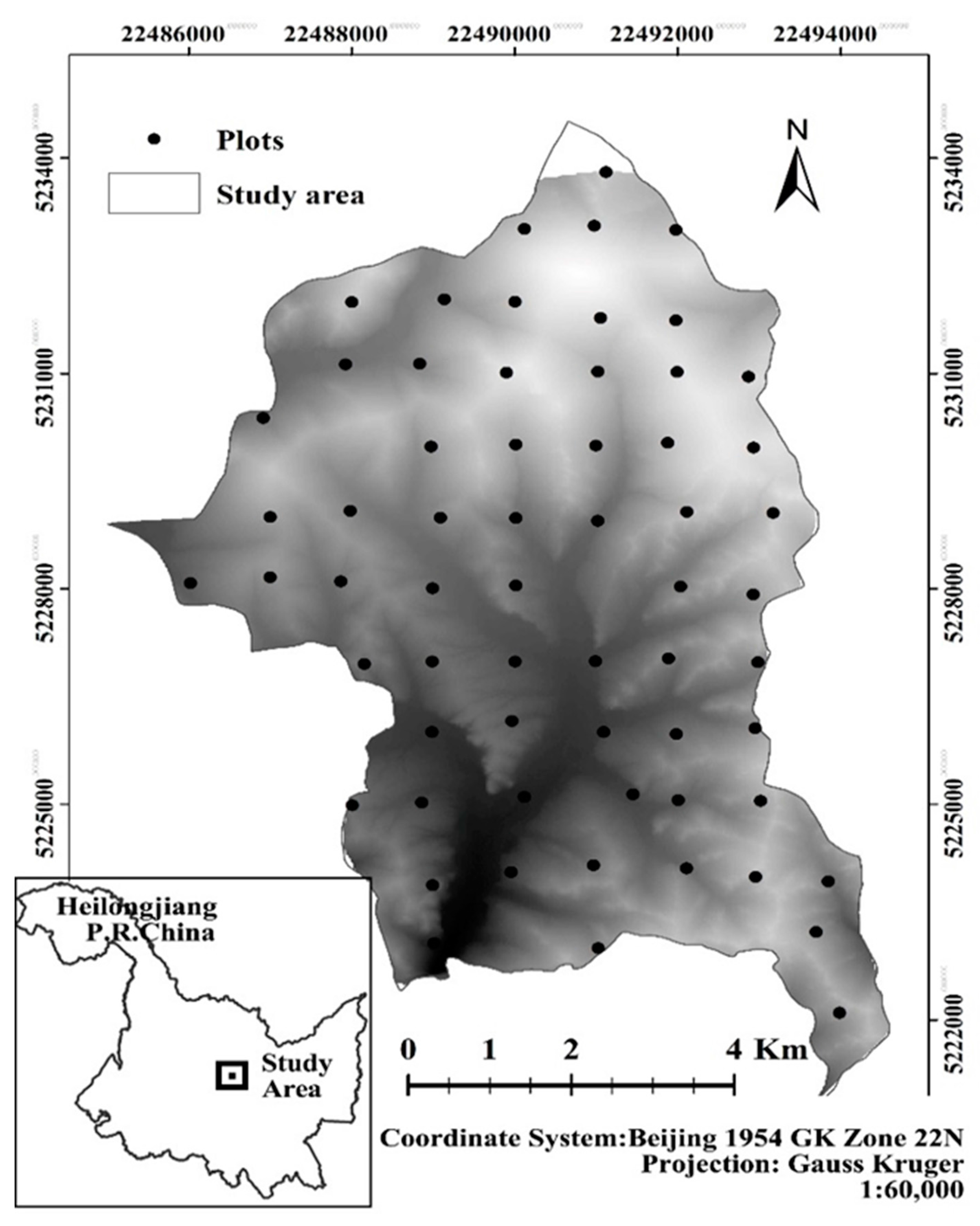
2.1. Study Area
2.2. Soil Data
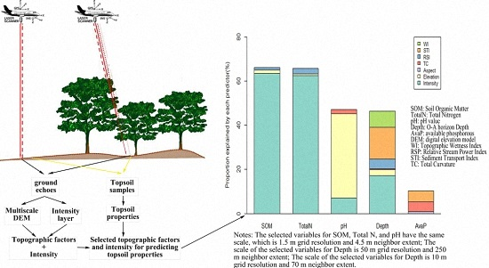
2.3. LiDAR Data
2.4. Statistics Analysis
3. Results
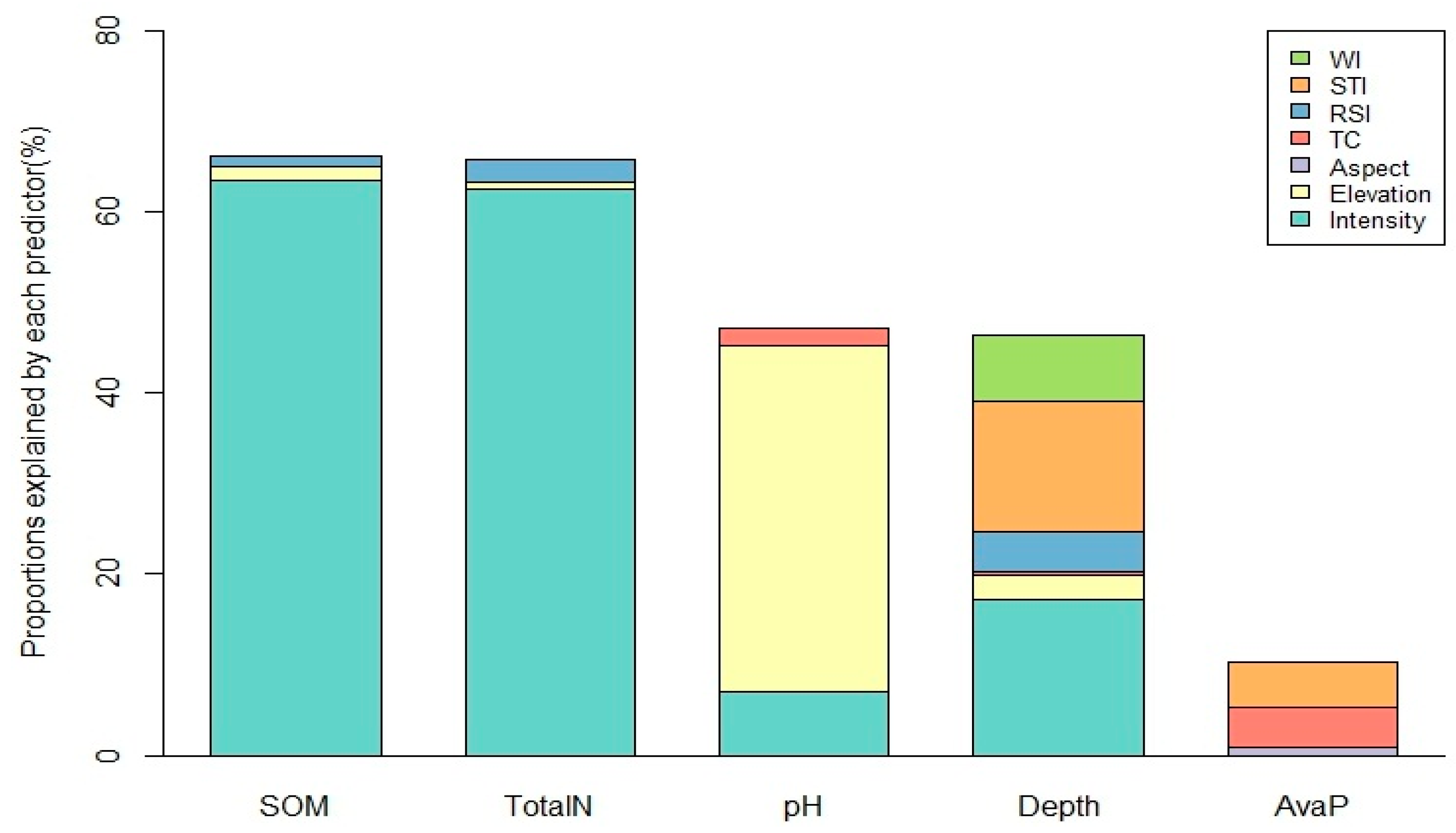
3.1. Correlation Analysis and Variable Selection
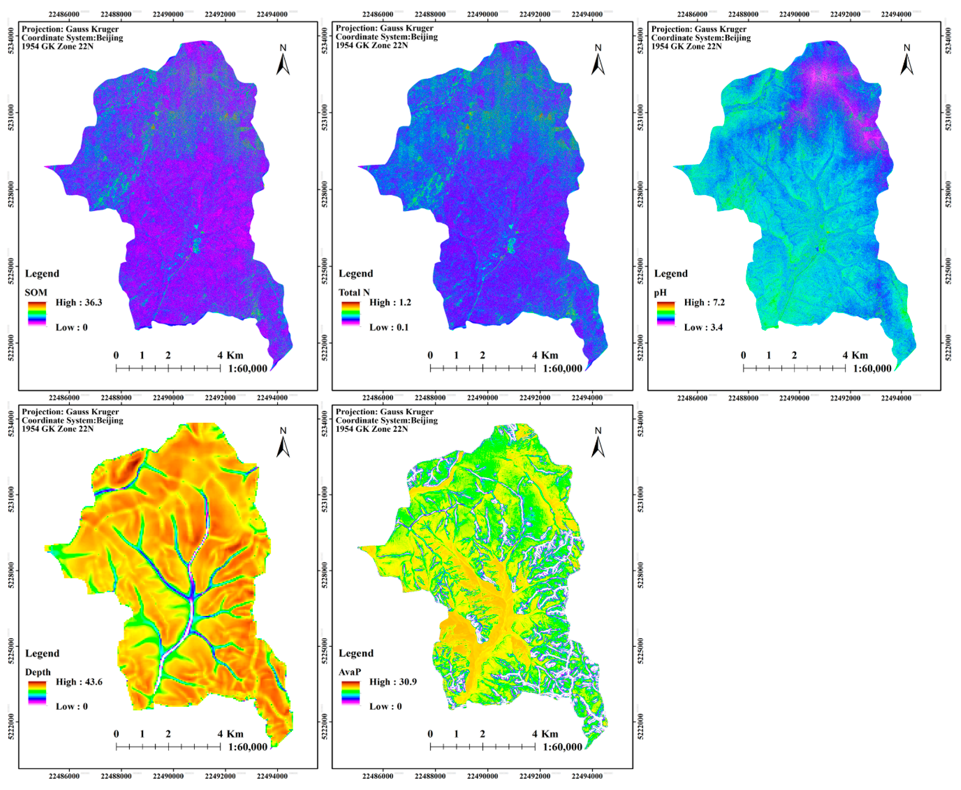
3.2. GLM Model and Soil Maps
4. Discussion
4.1. Effects and Scale Dependency of LiDAR Intensity on Topsoil Properties
4.2. Effects and Scale Dependency of Topographic Factors on Topsoil Properties
5. Conclusions
Supplementary Materials
Acknowledgments
Author Contributions
Conflicts of Interest
Abbreviations
| LiDAR | Light Detection and Ranging |
| SOM | Soil Organic Matter |
| Total N | Total Nitrogen |
| pH | pH value |
| Depth | O-A horizon Depth |
| AvaP | available phosphorous |
| 3D | three-dimensional |
| DEM | digital elevation model |
| R2 | Coefficient of determination |
| NIR-SWIR | Near Infrared to Short Wave Infrared |
| WI | Topographic Wetness Index |
| RSP | Relative Stream Power Index |
| STI | Sediment Transport Index |
| TC | Total Curvature |
| GPS | Global Positioning System |
| AIC | Akaike Information Criterion |
| GLM | General Linear Model regression |
References
- Susanne, A.; Wander, M.M. Long-Term Trends of Corn Yield and Soil Organic Matter in Different Crop Sequences and Soil Fertility Treatments on the Morrow Plots. Adv. Agron. 1997, 62, 153–197. [Google Scholar]
- Zhang, S.; Huang, Y.; Shen, C.; Ye, H.; Du, Y. Spatial prediction of soil organic matter using terrain indices and categorical variables as auxiliary information. Geoderma 2012, 171–172, 35–43. [Google Scholar] [CrossRef]
- McBratney, A.B.; Santos, M.M.; Minasny, B. On digital soil mapping. Geoderma 2003, 117, 3–52. [Google Scholar] [CrossRef]
- Moore, I.D.; Gessler, P.E.; Nielsen, G.A.; Peterson, G.A. Soil attribute prediction using terrain analysis. Soil Sci. Soc. Am. J. 1993, 57, 443–452. [Google Scholar] [CrossRef]
- Kienzle, S. The effect of DEM raster resolution on first order, second order and compound terrain derivatives. Trans. GIS 2004, 8, 83–111. [Google Scholar] [CrossRef]
- Maynard, J.J.; Johnson, M.G. Scale-dependency of LiDAR derived terrain attributes in quantitative soil-landscape modeling: Effects of grid resolution vs. neighborhood extent. Geoderma 2014, 230, 29–40. [Google Scholar] [CrossRef]
- Miller, B.A.; Koszinski, S.; Wehrhan, M.; Sommer, M. Impact of multi-scale predictor selection for modeling soil properties. Geoderma 2015, 239, 97–106. [Google Scholar] [CrossRef]
- Lin, Y.; Prentice, S.E.; Tran, T.; Bingham, N.L.; King, J.Y.; Chadwick, O.A. Modeling deep soil properties on California grassland hillslopes using LiDAR digital elevation models. Geoderma Reg. 2016, 7, 67–75. [Google Scholar] [CrossRef]
- Herbst, M.; Diekkrüger, B.; Vereecken, H. Geostatistical co-regionalization of soil hydraulic properties in a micro-scale catchment using terrain attributes. Geoderma 2006, 132, 206–221. [Google Scholar] [CrossRef]
- Takata, Y.; Funakawa, S.; Akshalov, K.; Ishida, N.; Kosaki, T. Spatial prediction of soil organic matter in northern Kazakhstan based on topographic and vegetation information. Soil Sci. Plant Nutr. 2007, 53, 289–299. [Google Scholar] [CrossRef]
- Griffiths, R.P.; Madritch, M.D.; Swanson, A.K. The effects of topography on forest soil characteristics in the Oregon Cascade Mountains (USA): Implications for the effects of climate change on soil properties. Forest Ecol. Manag. 2009, 257, 1–7. [Google Scholar] [CrossRef]
- Kumhálová, J.; Kumhála, F.; Kroulík, M.; Matějková, Š. The impact of topography on soil properties and yield and the effects of weather conditions. Precis. Agric. 2011, 12, 813–830. [Google Scholar] [CrossRef]
- Wang, S.; Wang, X.; Ouyang, Z. Effects of land use, climate, topography and soil properties on regional soil organic carbon and total nitrogen in the Upstream Watershed of Miyun Reservoir, North China. J. Environ. Sci. 2012, 24, 387–395. [Google Scholar] [CrossRef]
- Qi-yong, Y.; Zhong-cheng, J.; Wen-jun, L.; Hui, L. Prediction of soil organic matter in peak-cluster depression region using kriging and terrain indices. Soil Tillage Res. 2014, 144, 126–132. [Google Scholar] [CrossRef]
- Palacios-Orueta, A.; Ustin, S.L. Remote sensing of soil properties in the Santa Monica Mountains I. Spectral analysis. Remote Sens. Environ. 1998, 65, 170–183. [Google Scholar] [CrossRef]
- Chang, C.-W.; Laird, D.A.; Mausbach, M.J.; Hurburgh, C.R. Near-infrared reflectance spectroscopy–principal components regression analyses of soil properties. Soil Sci. Soc. Am. J. 2001, 65, 480–490. [Google Scholar] [CrossRef]
- Islam, K.; Singh, B.; McBratney, A. Simultaneous estimation of several soil properties by ultra-violet, visible, and near-infrared reflectance spectroscopy. Soil Res. 2003, 41, 1101–1114. [Google Scholar] [CrossRef]
- McCarty, G.W.; Reeves, J.B. Comparison of near infrared and mid infrared diffuse reflectance spectroscopy for field-scale measurement of soil fertility parameters. Soil Res. 2006, 171, 94–102. [Google Scholar] [CrossRef]
- Lefsky, M.A.; Cohen, W.B.; Harding, D.J.; Parker, G.G.; Acker, S.A.; Gower, S.T. Lidar remote sensing of above-ground biomass in three biomes. Glob. Ecol. Biogeogr. 2002, 11, 393. [Google Scholar] [CrossRef]
- Patenaude, G.; Hill, R.A.; Milne, R.; Gaveau, D.L.A.; Briggs, B.B.J.; Dawson, T.P. Quantifying forest above ground carbon content using LiDAR remote sensing. Remote Sens. Environ. 2004, 93, 368–380. [Google Scholar] [CrossRef]
- Müller, J.; Brandl, R. Assessing biodiversity by remote sensing in mountainous terrain: The potential for LiDAR to predict forest beetle assemblages. J. Appl. Ecol. 2009, 46, 897–905. [Google Scholar] [CrossRef]
- Bässler, C.; Stadler, J.; Müller, J.; Förster, B.; Göttlein, A.; Brandl, R. LiDAR as a rapid tool to predict forest habitat types in Natura 2000 networks. Biodivers. Conserv. 2011, 20, 465–481. [Google Scholar] [CrossRef]
- Wolf, G. LiDAR Goes Mainstream. In Transmission & Distribution World; Penton Business Media, Inc.: Overland Park, KS, USA, 2011. [Google Scholar]
- Hodgson, M.E.; Jensen, J.R.; Schmidt, L.; Schill, S.; Davis, B. An evaluation of LIDAR- and IFSAR-derived digital elevation models in leaf-on conditions with USGS Level 1 and Level 2 DEMs. Remote Sens. Environ. 2003, 84, 295–308. [Google Scholar] [CrossRef]
- Töyrä, J.; Pietroniro, A. Towards operational monitoring of a northern wetland using geomatics-based techniques. Remote Sens. Environ. 2005, 97, 174–191. [Google Scholar] [CrossRef]
- Murphy, P.N.C.; Ogilvie, J.; Meng, F.-R.; White, B.; Bhatti, J.S.; Arp, P.A. Modelling and mapping topographic variations in forest soils at high resolution: A case study. Ecol. Model. 2011, 222, 2314–2332. [Google Scholar] [CrossRef]
- Smeeckaert, J.; Mallet, C.; David, N.; Chehata, N.; Ferraz, A. Large-scale classification of water areas using airborne topographic lidar data. Remote Sens. Environ. 2013, 138, 134–148. [Google Scholar] [CrossRef]
- Song, J.; Han, S.; Yu, K.; Kim, Y. Assessing the possibility of land-cover classification using LiDAR intensity data. In Proceedings of the ISPRS Commission III, Graz, Austria, 9–13 September 2002.
- Yoon, J.S.; Shin, J.I.; Lee, K.S. Land cover characteristics of airborne LiDAR intensity data: A case study. IEEE Geosci. Remote Sens. Lett. 2008, 5, 801–805. [Google Scholar] [CrossRef]
- Yan, W.Y.; Shaker, A.; Habib, A.; Kersting, A.P. Improving classification accuracy of airborne LiDAR intensity data by geometric calibration and radiometric correction. ISPRS J. Photogramm. Remote Sens. 2012, 67, 35–44. [Google Scholar] [CrossRef]
- Andersen, H.-E.; Reutebuch, S.E.; McGaughey, R.J.; d’Oliveira, M.V.N.; Keller, M. Monitoring selective logging in western Amazonia with repeat lidar flights. Remote Sens. Environ. 2014, 151, 157–165. [Google Scholar] [CrossRef]
- Coren, F.; Sterzai, P. Radiometric correction in laser scanning. Int. J. Remote Sens. 2006, 27, 3097–3104. [Google Scholar] [CrossRef]
- Streutker, D.R.; Glenn, N.F. LiDAR measurement of sagebrush steppe vegetation heights. Remote Sens. Environ. 2006, 102, 135–145. [Google Scholar] [CrossRef]
- Sun, G.; Ranson, K.; Guo, Z.; Zhang, Z.; Montesano, P.; Kimes, D. Forest biomass mapping from lidar and radar synergies. Remote Sens. Environ. 2011, 115, 2906–2916. [Google Scholar] [CrossRef]
- Lang, M.W.; McCarty, G.W. Lidar intensity for improved detection of inundation below the forest canopy. Wetlands 2009, 29, 1166–1178. [Google Scholar] [CrossRef]
- Grebby, S.; Cunningham, D.; Naden, J.; Tansey, K. Lithological mapping of the Troodos ophiolite, Cyprus, using airborne LiDAR topographic data. Remote Sens. Environ. 2010, 114, 713–724. [Google Scholar] [CrossRef]
- Moffiet, T.; Mengersen, K.; Witte, C.; King, R.; Denham, R. Airborne laser scanning: Exploratory data analysis indicates potential variables for classification of individual trees or forest stands according to species. ISPRS J. Photogramm. Remote Sens. 2005, 59, 289–309. [Google Scholar] [CrossRef]
- Donoghue, D.N.M.; Watt, P.J.; Cox, N.J.; Wilson, J. Remote sensing of species mixtures in conifer plantations using LiDAR height and intensity data. Remote Sens. Environ. 2007, 110, 509–522. [Google Scholar] [CrossRef]
- Antonarakis, A.S.; Richards, K.S.; Brasington, J. Object-based land cover classification using airborne LiDAR. Remote Sens. Environ. 2008, 112, 2988–2998. [Google Scholar] [CrossRef]
- Kristensen, T.; Næsset, E.; Ohlson, M.; Bolstad, P.V.; Kolka, R. Mapping Above- and Below-Ground Carbon Pools in Boreal Forests: The Case for Airborne Lidar. PLoS ONE 2015, 10, e0138450. [Google Scholar] [CrossRef] [PubMed]
- Kaasalainen, S.; Pyysalo, U.; Krooks, A.; Vain, A.; Kukko, A.; Hyyppä, J.; Kaasalainen, M. Absolute Radiometric Calibration of ALS Intensity Data: Effects on Accuracy and Target Classification. Sensors 2011, 11, 10586–10602. [Google Scholar] [CrossRef] [PubMed]
- Southee, F.; Treitz, P.M.; Scott, N.A. Application of Lidar terrain surfaces for soil moisture modeling. Photogramm. Eng. Remote Sens. 2012, 78, 1241–1251. [Google Scholar] [CrossRef]
- Turner, R.; Panciera, R.; Tanase, M.A.; Lowell, K.; Hacker, J.M.; Walker, J.P. Estimation of soil surface roughness of agricultural soils using airborne LiDAR. Remote Sens. Environ. 2014, 140, 107–117. [Google Scholar] [CrossRef]
- Challis, K.; Carey, C.; Kincey, M.; Howard, A.J. Airborne lidar intensity and geoarchaeological prospection in river valley floors. Archaeol. Prospect. 2011, 18, 1–13. [Google Scholar] [CrossRef]
- Brady, N.C.; Weil, R.R. Elements of the Nature and Properties of Soils; Pearson Educational Incorporated: Upper Saddle River, NJ, USA, 2004. [Google Scholar]
- Liu, H.W.; Ding, Y.H. Analysis of daily precipitation characteristics over North China during rainy seasons. Chin. J. Atmosp. Sci. 2010, 34, 12–22, (In Chinese with English abstract). [Google Scholar]
- Soininen, A. TerrasScan User’s Guide; Terrasolid: Helsinki, Finland, 2005. [Google Scholar]
- Lindsay, J.B. The Whitebox Geospatial Analysis Tools project and open-access GIS. In Proceedings of the GIS Research 22nd UK Annual Conference, Glasgow, UK, 16–18 April 2014.
- Rinaldo, A.; Rodriguez-Iturbe, I.; Rigon, R.; Bras, R.L.; Ijjasz-Vasquez, E.; Marani, A. Minimum energy and fractal structures of drainage networks. Water Resour. Res. 1992, 28, 2183–2195. [Google Scholar] [CrossRef]
- Moore, I.D.; Burch, G.J. Physical basis of the length-slope factor in the Universal Soil Loss Equation. Soil Sci. Soc. Am. J. 1986, 50, 1294–1298. [Google Scholar] [CrossRef]
- Starek, M.; Luzum, B.; Kumar, R.; Slatton, K.C. Normalizing Lidar Intensities. GEM Center Report No. Rep_2006-12-001; University of Florida: Gainesville, FL, USA, 2006. [Google Scholar]
- García, M.; Riaño, D.; Chuvieco, E.; Danson, F.M. Estimating biomass carbon stocks for a Mediterranean forest in central Spain using LiDAR height and intensity data. Remote Sens. Environ. 2010, 114, 816–830. [Google Scholar] [CrossRef]
- Wang, Z.; Fang, J.; Tang, Z.; Lin, X. Patterns, determinants and models of woody plant diversity in China. Proc. Biol. Sci. 2011, 278, 2122–2132. [Google Scholar] [CrossRef] [PubMed]
- Tao, S.; Fang, J.; Zhao, X.; Zhao, S.; Shen, H.; Hu, H.; Tang, Z.; Wang, Z.; Guo, Q. Rapid loss of lakes on the Mongolian Plateau. Proc. Natl. Acad. Sci. USA 2015, 112, 2281–2286. [Google Scholar] [CrossRef] [PubMed]
- Burnham, K.P.; Anderson, D.R. Model-Selection and Multi-Model Inference: A Practical Information-Theoretic Approach; Springer: New York, NY, USA, 2002. [Google Scholar]
- Confalonieri, M.; Fornasier, F.; Ursino, A.; Boccardi, F.; Pintus, B.; Odoardi, M. The potential of near infrared reflectance spectroscopy as a tool for the chemical characterisation of agricultural soils. J. Near Infrared Spectrosc. 2001, 9, 123–131. [Google Scholar] [CrossRef]
- Jenny, H. The Soil Resource, Origin and Behavior; Springer-Verlag: New York, NY, USA, 1980. [Google Scholar]
- Yoo, K.; Amundson, R.; Heimsath, A.M.; Dietrich, W.E. Spatial patterns of soil organic carbon on hillslopes: Integrating geomorphic processes and the biological C cycle. Geoderma 2006, 130, 47–65. [Google Scholar] [CrossRef]


| Variable | N | Mean | Median | Std Error | Min | Max |
|---|---|---|---|---|---|---|
| SOM (%) | 62 | 12.11 | 11.94 | 0.57 | 3.21 | 26.3 |
| Total N (%) | 62 | 0.49 | 0.49 | 0.02 | 0.17 | 0.90 |
| pH | 62 | 5.41 | 5.35 | 0.05 | 4.77 | 6.35 |
| Depth (cm) | 62 | 19.67 | 20.13 | 0.84 | 6.33 | 32.80 |
| AvaP (ug/g) | 62 | 21.40 | 19.83 | 0.75 | 13.1 | 37.40 |
| SOM | Total N | pH | Depth | AvaP | ||||||
|---|---|---|---|---|---|---|---|---|---|---|
| Variables | R | p | r | p | r | p | R | p | r | p |
| Intensity | 0.80 a | 0.000 | 0.79 a | 0.000 | 0.27 a | 0.037 | −0.51 a | 0.000 | −0.17 d | 0.189 |
| Elevation | 0.18 a | 0.169 | 0.21 a | 0.107 | −0.49 a | 0.000 | −0.29 a | 0.020 | −0.13 g | 0.32 |
| Aspect | −0.13 c | 0.307 | −0.15 c | 0.243 | −0.17 a | 0.197 | −0.15 e | 0.251 | −0.19 d | 0.323 |
| Slope | 0.19 c | 0.142 | 0.20 c | 0.127 | −0.10 b | 0.427 | −0.27 h | 0.032 | −0.20 h | 0.128 |
| TC | −0.25 g | 0.051 | −0.27 g | 0.037 | 0.22 a | 0.092 | −0.23 a | 0.068 | −0.21 e | 0.103 |
| RSP | −0.21 a | 0.095 | −0.25 a | 0.046 | 0.17 h | 0.184 | −0.23 h | 0.074 | −0.17 a | 0.184 |
| STI | 0.14 b | 0.267 | 0.14 b | 0.293 | −0.15 b | 0.253 | −0.45 e | 0.000 | −0.25 g | 0.053 |
| WI | −0.17 a | 0.176 | −0.15 a | 0.26 | 0.15 h | 0.241 | −0.24 a | 0.064 | 0.08 f | 0.521 |
| Dep. | Intercept | Intensity | Elevation | Aspect | TC | RSP | STI | WI | AIC | R2 |
|---|---|---|---|---|---|---|---|---|---|---|
| SOM a | 3.2460 | 0.8793 | −0.0062 | −0.8439 | 304 | 0.663 | ||||
| Total N a | 0.2097 | 0.0261 | −0.0001 | −0.0353 | −128 | 0.657 | ||||
| pH a | 6.4130 | 0.0584 | −0.0040 | 0.0128 | −0.138 | 66 | 0.471 | |||
| Depth b | 50.694 | −0.3389 | −0.0170 | −91.86 | 0.0060 | 0.4203 | −1.7925 | 360 | 0.464 | |
| AvaP c | 24.94 | −0.0060 | −159.3 | −0.232 | 397 | 0.102 |
© 2016 by the authors; licensee MDPI, Basel, Switzerland. This article is an open access article distributed under the terms and conditions of the Creative Commons Attribution (CC-BY) license (http://creativecommons.org/licenses/by/4.0/).
Share and Cite
Li, C.; Xu, Y.; Liu, Z.; Tao, S.; Li, F.; Fang, J. Estimation of Forest Topsoil Properties Using Airborne LiDAR-Derived Intensity and Topographic Factors. Remote Sens. 2016, 8, 561. https://doi.org/10.3390/rs8070561
Li C, Xu Y, Liu Z, Tao S, Li F, Fang J. Estimation of Forest Topsoil Properties Using Airborne LiDAR-Derived Intensity and Topographic Factors. Remote Sensing. 2016; 8(7):561. https://doi.org/10.3390/rs8070561
Chicago/Turabian StyleLi, Chao, Yanli Xu, Zhaogang Liu, Shengli Tao, Fengri Li, and Jingyun Fang. 2016. "Estimation of Forest Topsoil Properties Using Airborne LiDAR-Derived Intensity and Topographic Factors" Remote Sensing 8, no. 7: 561. https://doi.org/10.3390/rs8070561
APA StyleLi, C., Xu, Y., Liu, Z., Tao, S., Li, F., & Fang, J. (2016). Estimation of Forest Topsoil Properties Using Airborne LiDAR-Derived Intensity and Topographic Factors. Remote Sensing, 8(7), 561. https://doi.org/10.3390/rs8070561