
Estimating Daily Maximum and Minimum Land Air Surface Temperature Using MODIS Land Surface Temperature Data and Ground Truth Data in Northern Vietnam


Abstract
:
1. Introduction
2. Materials and Methods
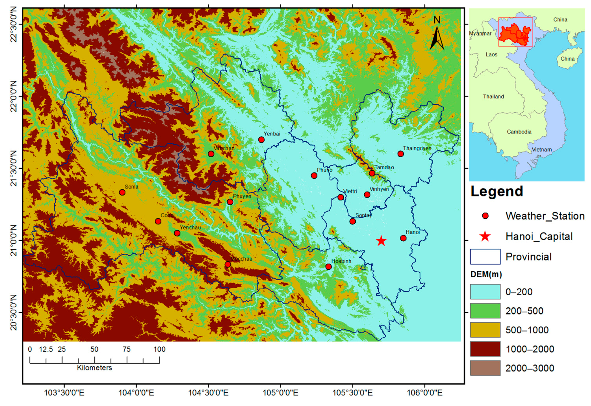
2.1. Study Area
- (1)
- Good distribution of meteorological station network in comparison to southern Vietnam.
- (2)
- Wide range of elevation (from approximately sea level to more than 3000 m).
- (3)
- The spatial heterogeneity of land cover.
- (4)
- There is no study about Ta estimation using all 4 MODIS LST datasets in northern Vietnam.
2.2. Data
2.2.1. Remote Sensing Data
MODIS LST Data
Elevation
Vegetation Based on NDVI
2.2.2. Meteorological Data
2.2.3. Auxiliary Data
2.3. Preprocessing Data
2.4. LST Data Retrieval at Weather Stations
2.5. Estimation of Land Air Surface Temperature Using MODIS LST and Auxiliary Data
2.5.1. Variable Selection
Pearson Correlation Coefficient
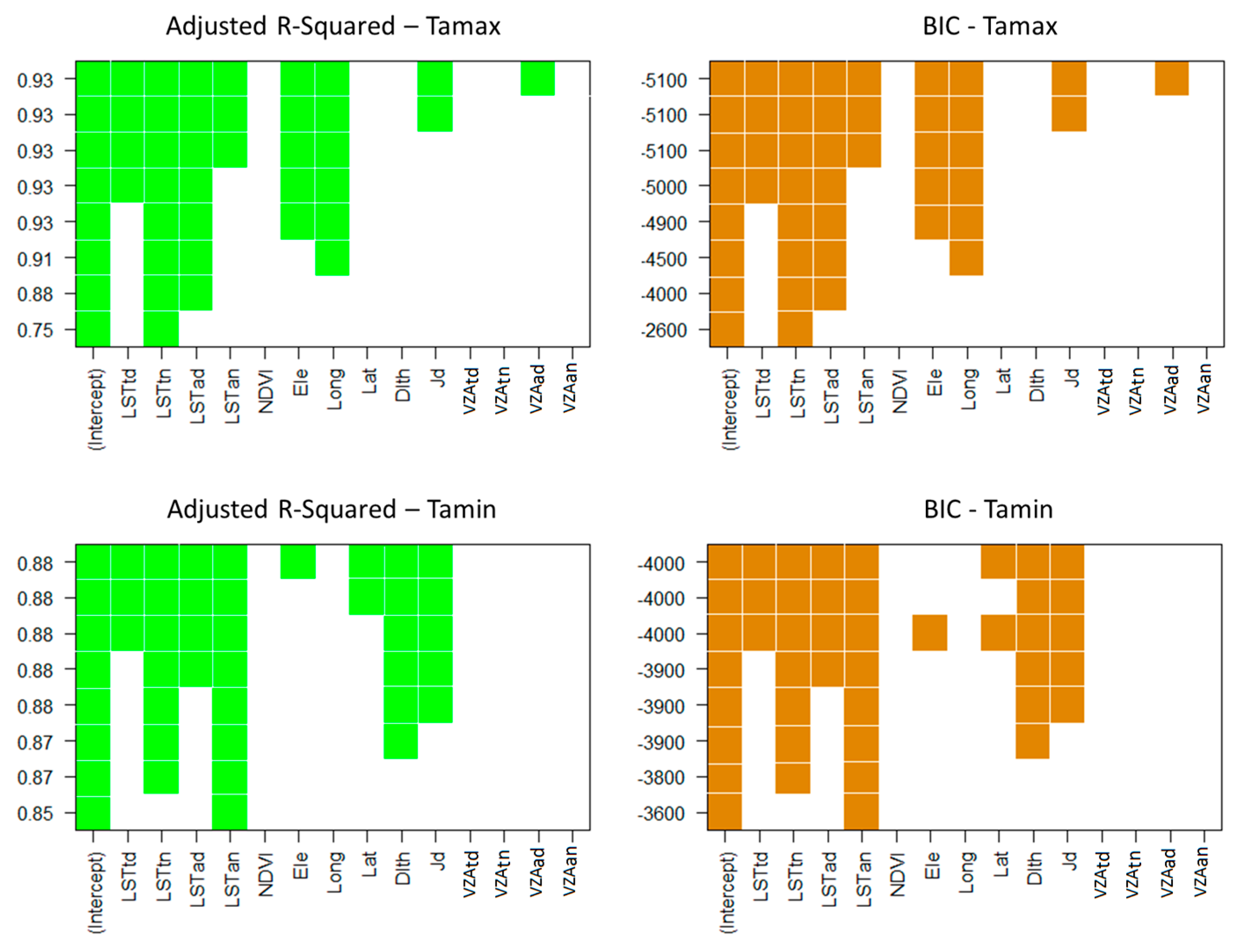
Variable Selection Based on Adjusted R-Squared () and BIC
Variable Selection Using Forward, Backward and Stepwise
Variable Selection-Based Principal Component Analysis (PCA)
2.5.2. Model Calibration and Validation
3. Results
3.1. The Relationship between MODIS LST and Ta
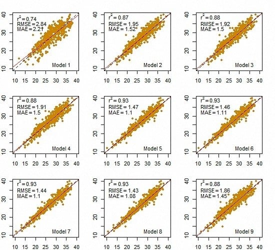
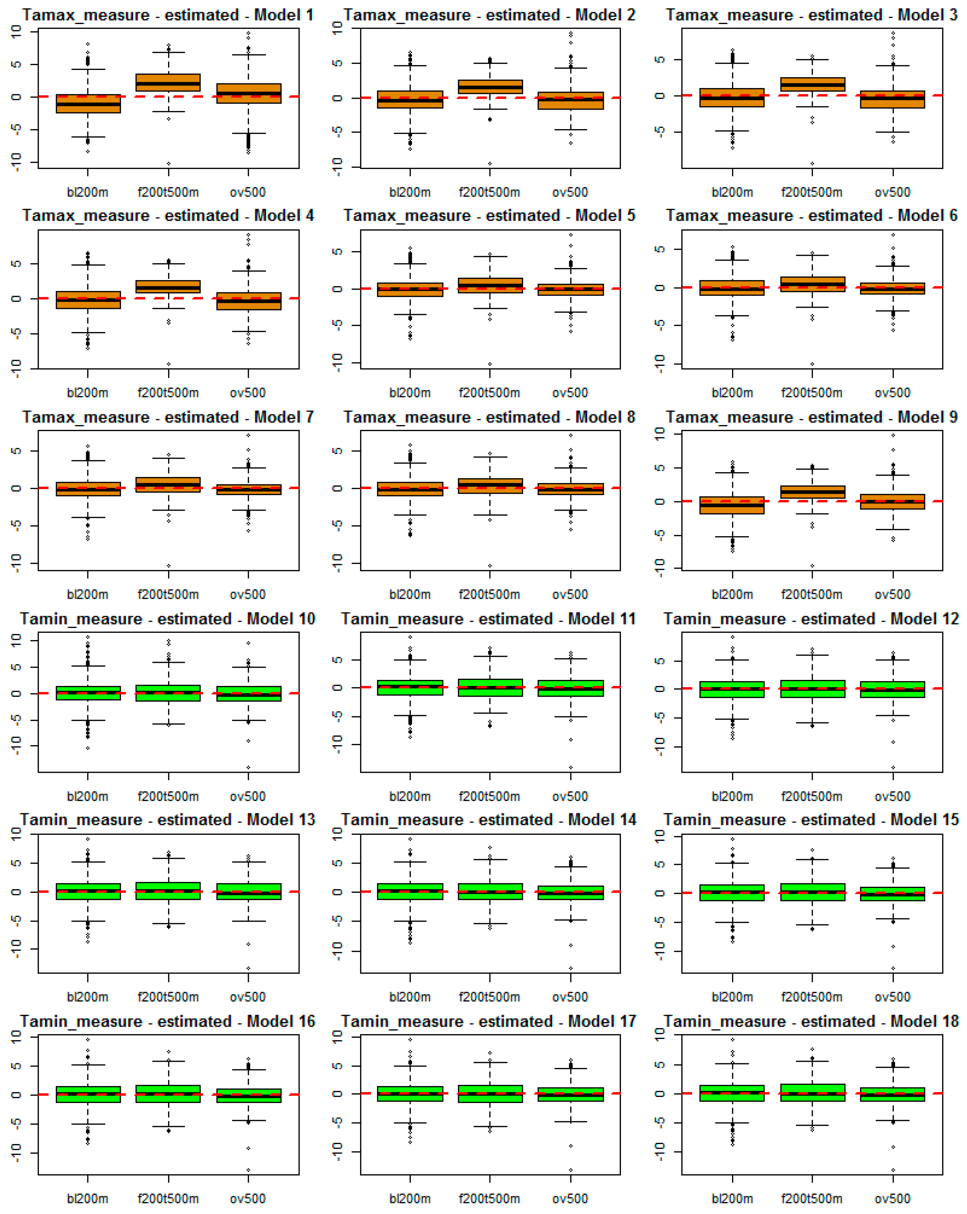
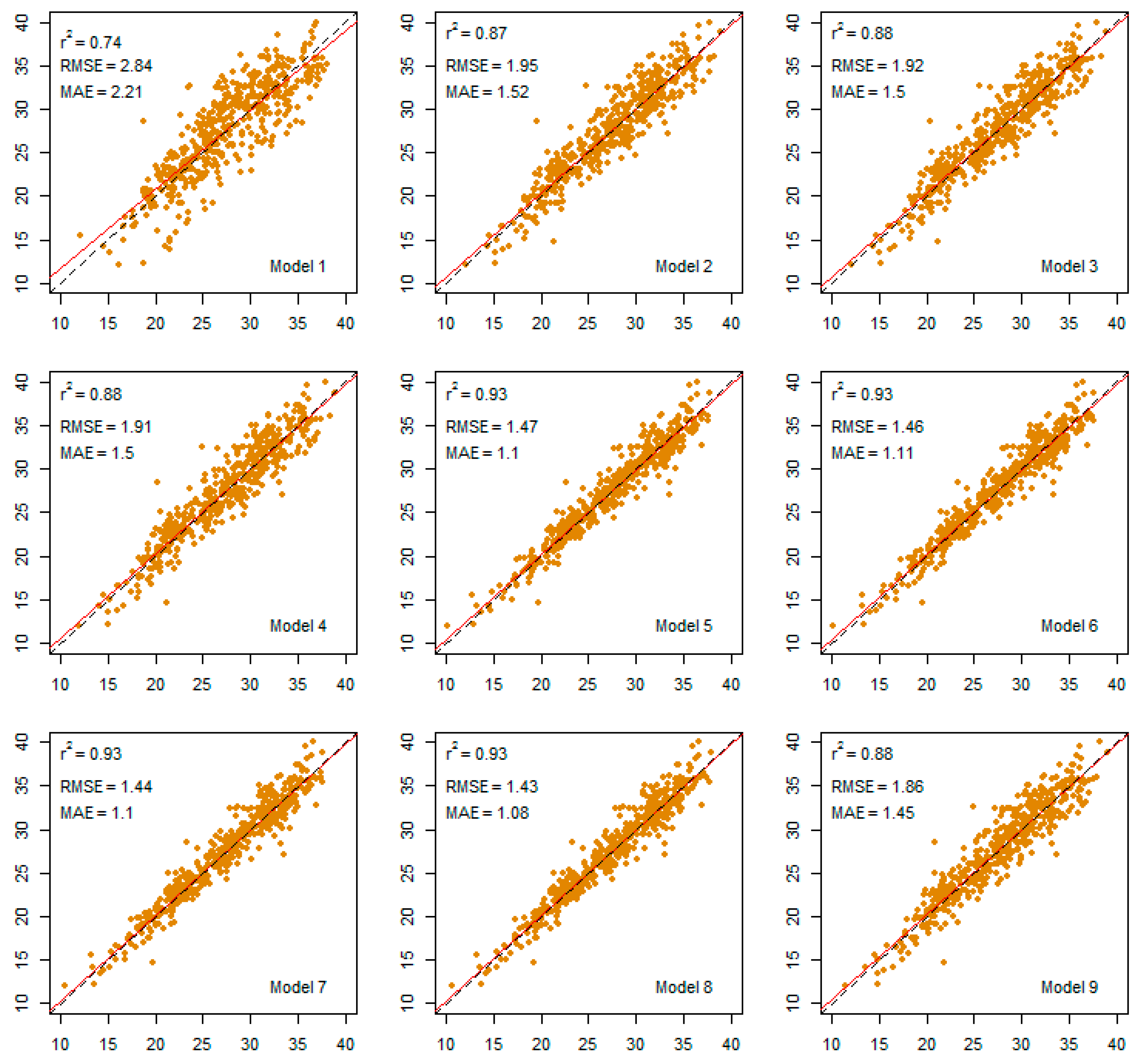
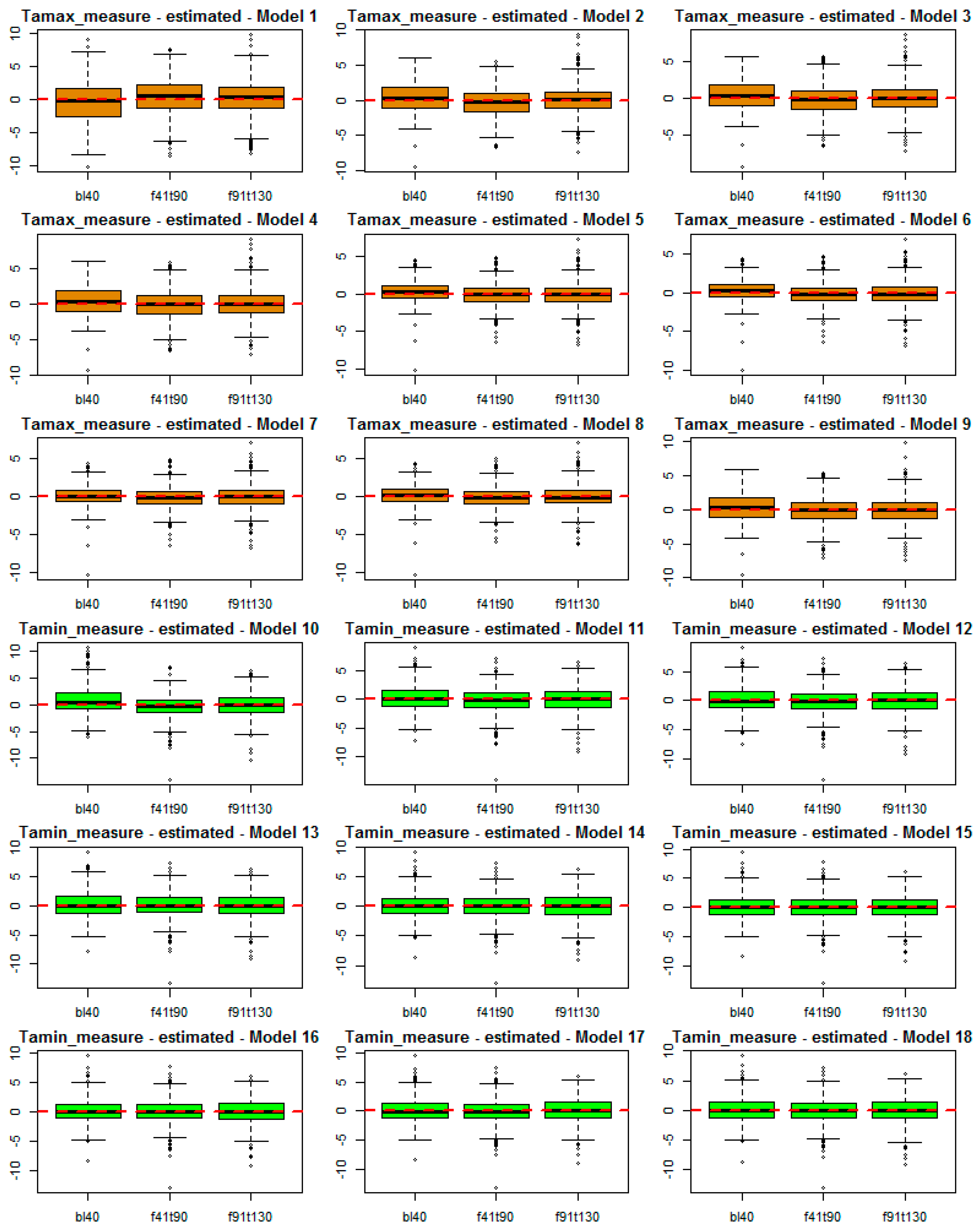
3.2. Ta-Max Estimation
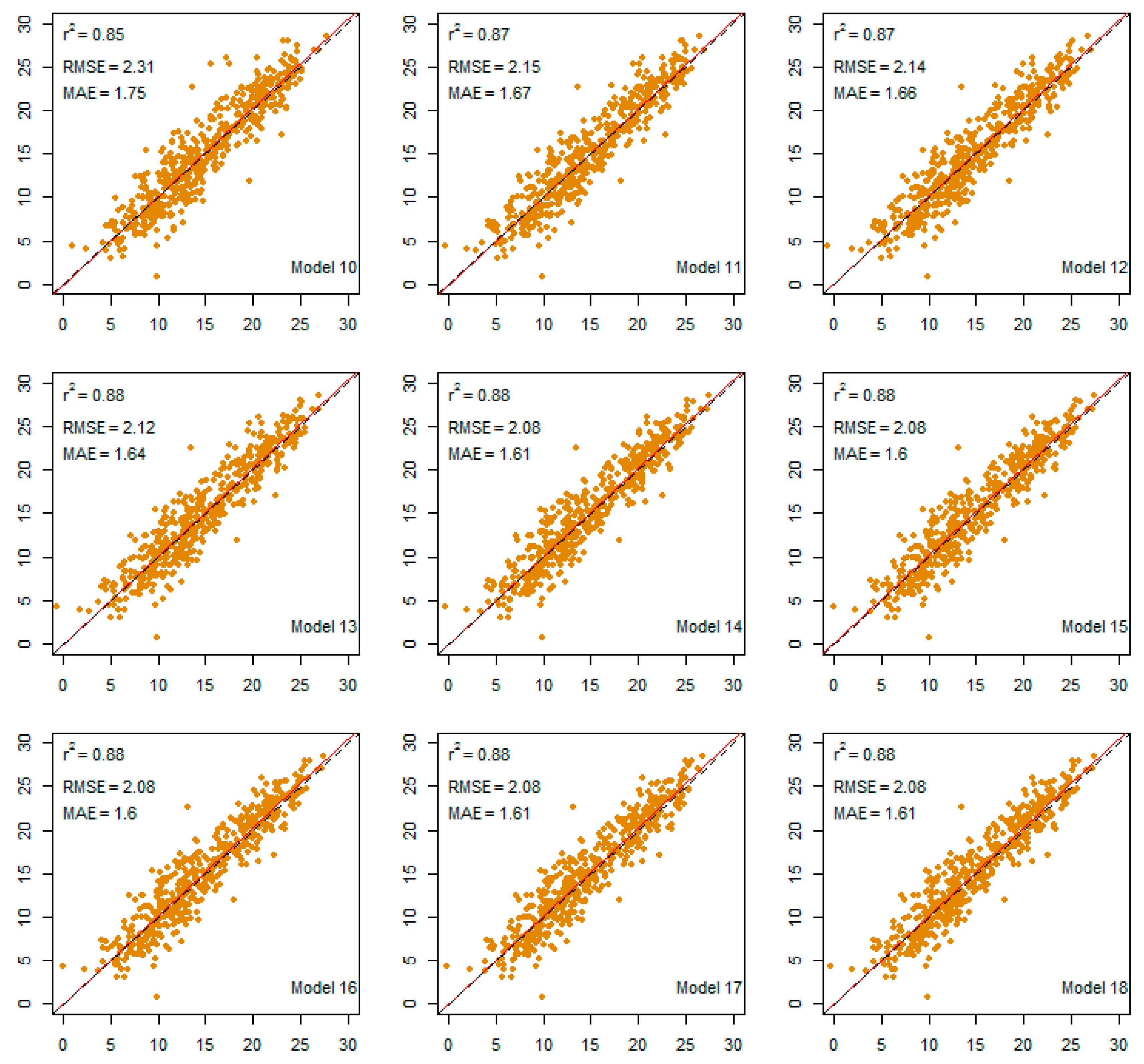
3.3. Ta-Min Estimation
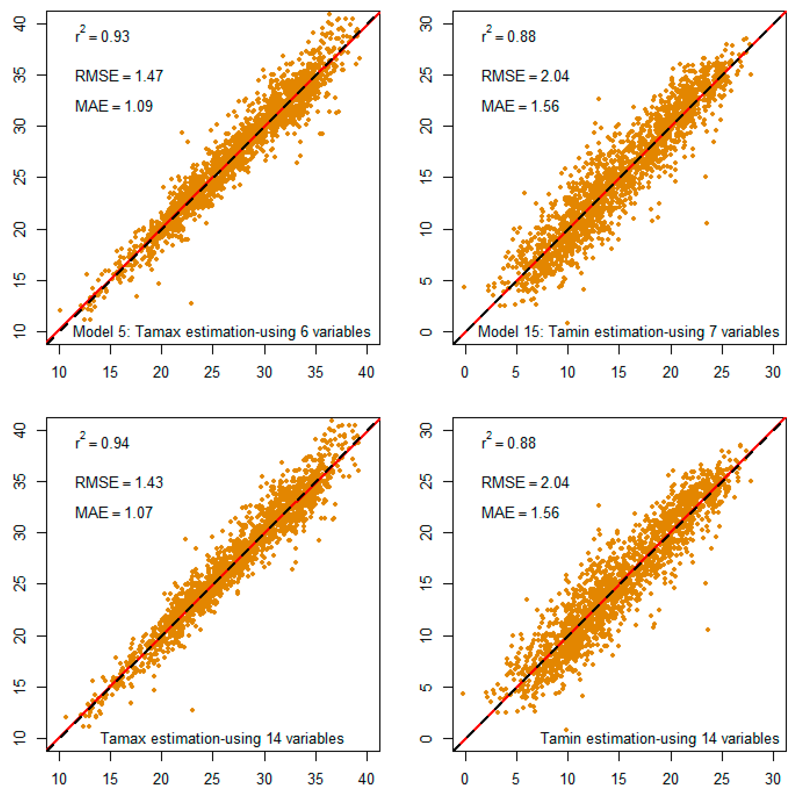
3.4. Performance of the Best Model
4. Discussion
4.1. MODIS LST Products for Ta Estimation
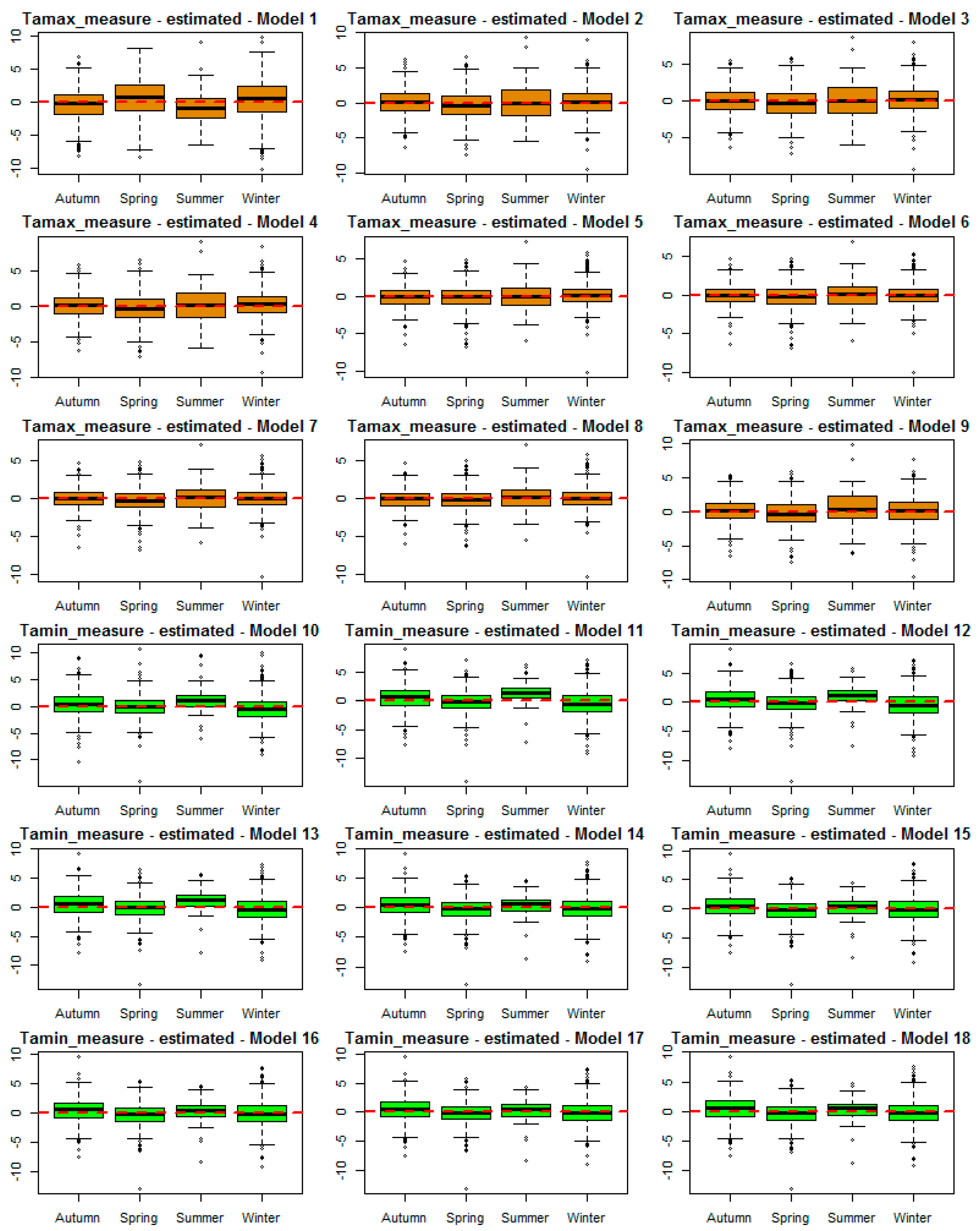
4.2. Effect of Seasonal on the Accuracy of Ta Estimation
4.3. Effect of View Zenith Angle on the Accuracy of Ta Estimation
4.4. Effect of Station Elevation on Accuracy
4.5. Accuracy Improvement by Integrating Four LST Products and Auxiliary Variables
4.5.1. For Ta-max Estimation
4.5.2. For Ta-min Estimation
5. Conclusions
Acknowledgments
Author Contributions
Conflicts of Interest
Appendix A

| Estimate | Std. Error | t-Value | p-Value | ||
|---|---|---|---|---|---|
| Model 1 | (Intercept) | 10.7057 | 0.2954 | 36.2400 | 0.0000 |
| LSTtn | 0.9826 | 0.0165 | 59.7200 | 0.0000 | |
| Model 2 | (Intercept) | 2.1651 | 0.3159 | 6.8530 | 0.0000 |
| LSTtn | 0.5778 | 0.0161 | 35.8360 | 0.0000 | |
| LSTad | 0.5133 | 0.0145 | 35.4500 | 0.0000 | |
| Model 3 | (Intercept) | 1.8313 | 0.3206 | 5.7110 | 0.0000 |
| LSTtd | 0.1234 | 0.0258 | 4.7810 | 0.0000 | |
| LSTtn | 0.5482 | 0.0171 | 32.0060 | 0.0000 | |
| LSTad | 0.4329 | 0.0221 | 19.5830 | 0.0000 | |
| Model 4 | (Intercept) | 1.7664 | 0.3226 | 5.4750 | 0.0000 |
| LSTtd | 0.1283 | 0.0259 | 4.9470 | 0.0000 | |
| LSTtn | 0.6028 | 0.0363 | 16.6280 | 0.0000 | |
| LSTad | 0.4305 | 0.0221 | 19.4510 | 0.0000 | |
| LSTan | −0.0570 | 0.0334 | −1.7080 | 0.0880 | |
| Model 5 | (Intercept) | 265.4000 | 9.1650 | 28.9520 | 0.0000 |
| LSTtd | 0.1646 | 0.0197 | 8.3610 | 0.0000 | |
| LSTtn | 0.5297 | 0.0274 | 19.3710 | 0.0000 | |
| LSTad | 0.2505 | 0.0176 | 14.2410 | 0.0000 | |
| LSTan | 0.1419 | 0.0260 | 5.4600 | 0.0000 | |
| Ele | −0.0028 | 0.0001 | −19.8260 | 0.0000 | |
| Long | −2.4810 | 0.0865 | −28.6960 | 0.0000 | |
| Model 6 | (Intercept) | 269.5000 | 9.1030 | 29.6050 | 0.0000 |
| LSTtd | 0.1712 | 0.0195 | 8.7690 | 0.0000 | |
| LSTtn | 0.5073 | 0.0274 | 18.5120 | 0.0000 | |
| LSTad | 0.2238 | 0.0182 | 12.3170 | 0.0000 | |
| LSTan | 0.1649 | 0.0261 | 6.3190 | 0.0000 | |
| Ele | −0.0029 | 0.0001 | −20.6540 | 0.0000 | |
| Long | −2.5100 | 0.0857 | −29.2840 | 0.0000 | |
| Jd | −0.0019 | 0.0004 | −5.1030 | 0.0000 | |
| Model 7 | (Intercept) | 270.1000 | 9.0700 | 29.7730 | 0.0000 |
| LSTtd | 0.1868 | 0.0201 | 9.3050 | 0.0000 | |
| LSTtn | 0.4746 | 0.0292 | 16.2390 | 0.0000 | |
| LSTad | 0.2178 | 0.0182 | 11.9700 | 0.0000 | |
| LSTan | 0.1886 | 0.0271 | 6.9660 | 0.0000 | |
| Ele | −0.0029 | 0.0001 | −20.8160 | 0.0000 | |
| Long | −2.5130 | 0.0854 | −29.4290 | 0.0000 | |
| Jd | −0.0020 | 0.0004 | −5.3020 | 0.0000 | |
| VZAad | −0.0037 | 0.0012 | −3.1350 | 0.0018 | |
| Model 8 | (Intercept) | 285.4000 | 9.9020 | 28.8230 | 0.0000 |
| LSTtd | 0.1812 | 0.0218 | 8.3240 | 0.0000 | |
| LSTtn | 0.4523 | 0.0314 | 14.3870 | 0.0000 | |
| LSTad | 0.2445 | 0.0212 | 11.5410 | 0.0000 | |
| LSTan | 0.2013 | 0.0294 | 6.8500 | 0.0000 | |
| NDVI | 1.6500 | 0.3829 | 4.3090 | 0.0000 | |
| Ele | −0.0033 | 0.0002 | −19.8170 | 0.0000 | |
| Long | −2.5080 | 0.0847 | −29.6040 | 0.0000 | |
| Lat | −0.7172 | 0.1754 | −4.0890 | 0.0000 | |
| Dlth | −0.1648 | 0.0950 | −1.7350 | 0.0829 | |
| Jd | −0.0024 | 0.0004 | −6.0140 | 0.0000 | |
| VZAtd | 0.0021 | 0.0013 | 1.6460 | 0.1001 | |
| VZAad | −0.0038 | 0.0012 | −3.2710 | 0.0011 | |
| Model 9 | (Intercept) | 4.6214 | 1.2432 | 3.7170 | 0.0002 |
| LSTtd | 0.1701 | 0.0259 | 6.5730 | 0.0000 | |
| LSTtn | 0.5597 | 0.0367 | 15.2720 | 0.0000 | |
| LSTad | 0.4074 | 0.0225 | 18.0830 | 0.0000 | |
| LSTan | −0.0463 | 0.0337 | −1.3720 | 0.1704 | |
| Ele | −0.0013 | 0.0002 | −7.2070 | 0.0000 | |
| Dlth | −0.1617 | 0.1235 | −1.3090 | 0.1907 | |
| Jd | −0.0013 | 0.0005 | −2.5570 | 0.0107 |
Appendix B
| Estimate | Std. Error | t-Value | p-Value | ||
|---|---|---|---|---|---|
| Model 10 | (Intercept) | −1.5176 | 0.2085 | −7.2800 | 0.0000 |
| LSTan | 1.0157 | 0.0121 | 83.9300 | 0.0000 | |
| Model 11 | (Intercept) | −2.4950 | 0.2178 | −11.4600 | 0.0000 |
| LSTtn | 0.4055 | 0.0371 | 10.9200 | 0.0000 | |
| LSTan | 0.6492 | 0.0355 | 18.2900 | 0.0000 | |
| Model 12 | (Intercept) | −1.4608 | 0.3340 | −4.3730 | 0.0000 |
| LSTtn | 0.4496 | 0.0385 | 11.6920 | 0.0000 | |
| LSTad | −0.0620 | 0.0153 | −4.0640 | 0.0001 | |
| LSTan | 0.6541 | 0.0353 | 18.5420 | 0.0000 | |
| Model 13 | (Intercept) | −1.6875 | 0.3420 | −4.9350 | 0.0000 |
| LSTtd | 0.0800 | 0.0275 | 2.9080 | 0.0037 | |
| LSTtn | 0.4417 | 0.0384 | 11.4950 | 0.0000 | |
| LSTad | −0.1139 | 0.0235 | −4.8570 | 0.0000 | |
| LSTan | 0.6425 | 0.0354 | 18.1590 | 0.0000 | |
| Model 14 | (Intercept) | −10.9000 | 1.3100 | −8.3200 | 0.0000 |
| LSTtd | 0.0544 | 0.0271 | 2.0060 | 0.0450 | |
| LSTtn | 0.4210 | 0.0382 | 11.0130 | 0.0000 | |
| LSTad | −0.0931 | 0.0239 | −3.9020 | 0.0001 | |
| LSTan | 0.5800 | 0.0358 | 16.2000 | 0.0000 | |
| Dlth | 0.8850 | 0.1280 | 6.9320 | 0.0000 | |
| Jd | 0.0020 | 0.0005 | 3.6870 | 0.0002 | |
| Model 15 | (Intercept) | 6.4498 | 5.2374 | 1.2310 | 0.2184 |
| LSTtd | 0.0479 | 0.0271 | 1.7700 | 0.0769 | |
| LSTtn | 0.4187 | 0.0380 | 11.0110 | 0.0000 | |
| LSTad | −0.0998 | 0.0238 | −4.1890 | 0.0000 | |
| LSTan | 0.5885 | 0.0357 | 16.4770 | 0.0000 | |
| Dlth | 0.9112 | 0.1273 | 7.1560 | 0.0000 | |
| Jd | 0.0020 | 0.0005 | 3.7160 | 0.0002 | |
| Lat | −0.8214 | 0.2397 | −3.4280 | 0.0006 | |
| Model 16 | (Intercept) | 7.0965 | 5.2666 | 1.3470 | 0.1781 |
| LSTtd | 0.0529 | 0.0274 | 1.9320 | 0.0537 | |
| LSTtn | 0.4097 | 0.0388 | 10.5540 | 0.0000 | |
| LSTad | −0.1027 | 0.0239 | −4.2870 | 0.0000 | |
| LSTan | 0.5864 | 0.0358 | 16.3970 | 0.0000 | |
| Dlth | 0.9479 | 0.1312 | 7.2230 | 0.0000 | |
| Jd | 0.0019 | 0.0005 | 3.5110 | 0.0005 | |
| Lat | −0.8599 | 0.2419 | −3.5540 | 0.0004 | |
| Ele | −0.0002 | 0.0002 | −1.1540 | 0.2487 | |
| Model 17 | (Intercept) | 10.9860 | 5.3900 | 2.0380 | 0.0418 |
| LSTtd | 0.0740 | 0.0284 | 2.6070 | 0.0093 | |
| LSTtn | 0.3827 | 0.0412 | 9.2900 | 0.0000 | |
| LSTad | −0.0913 | 0.0245 | −3.7250 | 0.0002 | |
| LSTan | 0.5887 | 0.0376 | 15.6640 | 0.0000 | |
| NDVI | 1.6296 | 0.5405 | 3.0150 | 0.0026 | |
| Ele | −0.0006 | 0.0002 | −2.5960 | 0.0096 | |
| Lat | −1.0290 | 0.2479 | −4.1510 | 0.0000 | |
| Dlth | 0.8447 | 0.1343 | 6.2910 | 0.0000 | |
| Jd | 0.0015 | 0.0005 | 2.6990 | 0.0071 | |
| VZAad | −0.0027 | 0.0016 | −1.6590 | 0.0973 | |
| Model 18 | (Intercept) | −11.0000 | 1.3200 | −8.3410 | 0.0000 |
| LSTtd | 0.0575 | 0.0275 | 2.0890 | 0.0369 | |
| LSTtn | 0.4160 | 0.0390 | 10.6610 | 0.0000 | |
| LSTad | −0.0946 | 0.0240 | −3.9460 | 0.0001 | |
| LSTan | 0.5790 | 0.0359 | 16.1250 | 0.0000 | |
| Ele | −0.0001 | 0.0002 | −0.6680 | 0.5043 | |
| Dlth | 0.9060 | 0.1310 | 6.8960 | 0.0000 | |
| Jd | 0.0019 | 0.0005 | 3.5520 | 0.0004 |
References
- De Bruin, H.A.R.; Trigo, I.F.; Jitan, M.A.; TemesgenEnku, N.; van der Tol, C.; Gieske, A.S.M. Reference crop evapotranspiration derived from geo-stationary satellite imagery: A case study for the Fogera flood plain, NW-Ethiopia and the Jordan Valley, Jordan. Hydrol. Earth Syst. Sci. 2010, 14, 2219–2228. [Google Scholar] [CrossRef]
- Balaghi, R.; Tychon, B.; Eerens, H.; Jlibene, M. Empirical regression models using NDVI, rainfall and temperature data for early prediction of wheat grain yields in Morocco. Int. J. Appl. Earth Obs. 2008, 10, 438–452. [Google Scholar] [CrossRef]
- De Wit, A.J.W.; van Diepen, C.A. Crop growth modelling and crop yield forecasting using satellite-derived meteorological inputs. Int. J. Appl. Earth Obs. 2008, 10, 414–425. [Google Scholar] [CrossRef]
- Lehman, J.T. Application of satellite AVHRR to water balance mixing dynamics and the chemistry of Lake Edward, East Africa. In The East African Great Lakes: Limnology, Palaeolimnology and Biodiversity; Odada, E.O., Olago, D.O., Eds.; Kluwer Academic Publishers: Dordrecht, The Netherlands, 2002; pp. 235–260. [Google Scholar]
- Vallet-Coulomb, C.; Legesse, D.; Gasse, F.; Travi, Y.; Chernet, T. Lake evaporation estimates in tropical Africa (Lake Ziway, Ethiopia). J. Hydrol. 2001, 245, 1–18. [Google Scholar] [CrossRef]
- Intergovernmental Panel on Climate Change (IPCC). Climate Change 2001: The Scientific Basis; Contribution of Working Group I to the Third Assessment Report of the Intergovernmental Panel on Climate Change; Cambridge University Press: Cambridge, UK, 2001; p. 881. [Google Scholar]
- Intergovernmental Panel on Climate Change (IPCC). Climate Change 2007: The Physical Science Basis; Contribution of Working Group I to the Fourth Assessment Report of the Intergovernmental Panel on Cli-mate Change; Solomon, S., Qin, D., Manning, M., Chen, Z., Marquis, M., Averyt, K.B., Tignor, M., Miller, H.L., Eds.; Cambridge University Press: Cambridge, UK, 2007. [Google Scholar]
- Fu, G.; Shen, Z.X.; Zhang, X.Z.; Shi, P.L.; Zhang, Y.J.; Wu, J.S. Estimating air temperature of an alpine meadow on the Northern Tibetan Plateau using MODIS land surface temperature. Acta Ecol. Sin. 2011, 21, 8–13. [Google Scholar] [CrossRef]
- Stisen, S.; Sandholt, I.; Norgaard, A.; Fensholt, R.; Eklundh, L. Estimation of diurnal air temperature using MSG SEVIRI data in West Africa. Remote Sens. Environ. 2007, 110, 262–274. [Google Scholar] [CrossRef]
- Nieto, H.; Sandholt, I.; Aguado, I.; Chuvieco, E.; Stisen, S. Air temperature estimation with MSG-SEVIRI data: Calibration and validation of the TVX algorithm for the Iberian Peninsula. Remote Sens. Environ. 2011, 115, 107–116. [Google Scholar] [CrossRef]
- Lin, S.; Moore, N.J.; Messina, J.P.; de Visser, M.H.; Wu, J. Evaluation of estimating daily maximum and minimum air temperature with MODIS data in east Africa. Int. J. Appl. Earth Obs. Geoinf. 2012, 18, 128–140. [Google Scholar] [CrossRef]
- Basist, A.N.; Peterson, N.C.; Peterson, T.C.; Williams, C.N. Using the special sensor mi-crowave/imager to monitor land surface temperature, wetness, and snow cover. J. Appl. Meteorol. 1998, 37, 888–911. [Google Scholar] [CrossRef]
- Peterson, T.C.; Basist, A.N.; Williams, C.; Grody, N. A blended satellite/in situ near-global surface temperature data set. Bull. Am. Meteorol. Soc. 2000, 81, 2157–2164. [Google Scholar] [CrossRef]
- Florio, E.N.; Lele, S.R.; Chi Chang, Y.; Sterner, R.; Glass, G.E. Integrating AVHRR satellite data and NOAA ground observations to predict surface air temperature: A statistical approach. Int. J. Remote Sens. 2004, 25, 2979–2994. [Google Scholar] [CrossRef]
- Vancutsem, C.; Ceccato, P.; Dinku, T.; Connor, S.J. Evaluation of MODIS land surface temperature data to estimate air temperature in different ecosystems over Africa. Remote Sens. Environ. 2010, 114, 449–465. [Google Scholar] [CrossRef]
- Vogt, J.V.; Viau, A.A.; Paquet, F. Mapping regional air temperature fields using satellite-derived surface skin temperatures. Int. J. Climatol. 1997, 17, 1559–1579. [Google Scholar] [CrossRef]
- Lai, Y.J.; Li, C.F.; Lin, P.H.; Wey, T.H.; Chang, C.S. Comparison of MODIS land surface temperature and ground-based observed air temperature in complex topography. Int. J. Remote Sens. 2012, 33, 7685–7702. [Google Scholar] [CrossRef]
- Sun, H.; Chen, Y.; Gong, A.; Zhao, X.; Zhan, W.; Wang, M. Estimating mean air temperature using MODIS day and night land surface temperatures. Theor. Appl. Climatol. 2014, 118, 81–92. [Google Scholar] [CrossRef]
- Dinh, V.V. Country Report the hydro meteorological service of Vietnam and its modernization plan. In Proceedings of the 5th Global Precipitation Measurement (GPM) International Planning Workshop, Tokyo, Japan, 7–9 November 2005.
- Coll, C.; Caselles, V.; Sobrino, J.A.; Valor, E. On the atmospheric dependence of the split-window equation for land surface temperature. Int. J. Remote Sens. Environ. 1994, 27, 105–122. [Google Scholar] [CrossRef]
- Wan, Z.; Dozier, J. A generalized split-window algorithm for retrieving land-surface temperature from space. IEEE Trans. Geosci. Remote Sens. 1996, 34, 892–905. [Google Scholar]
- Cresswell, M.P.; Morse, A.P.; Thomson, M.C.; Connor, S.J. Estimating surface air temperatures, from Meteosat land surface temperatures, using an empirical solar zenith angle model. Int. J. Remote Sens. 1999, 20, 1125–1132. [Google Scholar] [CrossRef]
- Williamson, S.; Hik, D.; Gamon, J.; Kavanaugh, J.; Flowers, G. Estimating temperature fields from MODIS land surface temperature and air temperature observations in a sub-arctic alpine environment. Remote Sens. 2014, 6, 946–963. [Google Scholar] [CrossRef]
- Prince, S.D.; Goetz, S.J.; Dubayah, R.O.; Czajkowski, K.P.; Thawley, M. Inference of surface and air temperature, atmospheric precipitable water and vapor pressure deficit using advanced very high-resolution radiometer satellite observations: Comparison with field observations. J. Hydrol. 1998, 213, 230–249. [Google Scholar] [CrossRef]
- Mostovoy, G.V.; King, R.L.; Reddy, K.R.; Kakani, V.G.; Filippova, M.G. Statistical estimation of daily maximum and minimum air temperatures from MODIS LST data over the state of Mississippi. GISci. Remote Sens. 2006, 43, 78–110. [Google Scholar] [CrossRef]
- Jin, M.; Dickinson, R.E. Land surface skin temperature climatology: Benefitting from the strengths of satellite observations. Environ. Res. Lett. 2010, 5, 044004. [Google Scholar] [CrossRef]
- Lin, X.; Zhang, W.; Huang, Y.; Sun, W.; Han, P.; Yu, L.; Sun, F. Empirical estimation of near-surface air temperature in China from MODIS LST data by considering physiographic features. Remote Sens. 2016, 8, 629. [Google Scholar] [CrossRef]
- Gallo, K.; Hale, R.; Tarpley, D.; YU, Y. Evaluation of the relationship between air and land surface temperature under clear- and cloudy-sky conditions. J. Appl. Meteorol. Climatol. 2011, 50, 767–775. [Google Scholar] [CrossRef]
- Benali, A.; Carvalho, A.C.; Nunes, J.P.; Carvalhais, N.; Santos, A. Estimating air surface temperature in Portugal using MODIS LST data. Remote Sens. Environ. 2012, 124, 108–121. [Google Scholar] [CrossRef]
- Crosson, W.L.; Al-Hamdan, M.Z.; Hemmings, S.N.; Wade, G.M. A daily merged MODIS Aqua–Terra land surface temperature data set for the conterminous United States. Remote Sens. Environ. 2012, 119, 315–324. [Google Scholar] [CrossRef]
- Zeng, L.; Wardlow, B.D.; Tadesse, T.; Shan, J.; Hayes, M.J.; Li, D.; Xiang, D. Estimation of daily air temperature based on MODIS land surface temperature products over the corn belt in the US. Remote Sens. 2015, 7, 951–970. [Google Scholar] [CrossRef]
- Xu, Y.; Qin, Z.; Shen, Y. Study on the estimation of near-surface air temperature from MODIS data by statistical methods. Int. J. Remote Sens. 2012, 33, 7629–7643. [Google Scholar] [CrossRef]
- Huang, R.; Zhang, C.; Huang, J.; Zhu, D.; Wang, L.; Liu, J. Mapping of daily mean air temperature in agricultural regions using daytime and nighttime land surface temperatures derived from Terra and Aqua MODIS data. Remote Sens. 2015, 7, 8728–8756. [Google Scholar] [CrossRef]
- Zakšek, K.; Schroedter-Homscheidt, M. Parameterization of air temperature in high temporal and spatial resolution from a combination of the SEVIRI and MODIS instruments. ISPRS J. Photogramm. Remote Sens. 2009, 64, 414–421. [Google Scholar] [CrossRef]
- Prihodko, L.; Goward, S.N. Estimation of air temperature from remotely sensed surface observations. Remote Sens. Environ. 1997, 60, 335–346. [Google Scholar] [CrossRef]
- Goetz, S.J. Multi-sensor analysis of NDVI, surface temperature and biophysical variables at amixed grassland site. Int. J. Remote Sens. 1997, 18, 71–94. [Google Scholar] [CrossRef]
- Goetz, S.J.; Prince, S.D.; Small, J. Advances in satellite remote sensing of environmental variables for epidemiological applications. Adv. Parasitol. 2000, 47, 289–307. [Google Scholar] [PubMed]
- Zhu, W.; Lű, A.; Jia, S. Estimation of daily maximum and minimum air temperature using MODIS land surface temperature products. Remote Sens. Environ. 2013, 130, 62–73. [Google Scholar] [CrossRef]
- Sun, H.; Zhao, X.; Chen, Y.; Gong, A.; Yang, J. A new agricultural drought monitoring index combining MODIS NDWI and day–night land surface temperatures: A case study in China. Int. J. Remote Sens. 2013, 34, 8986–9001. [Google Scholar] [CrossRef]
- Sandholt, I.; Rasmussen, K.; Andersen, J. A simple interpretation of the surface temperature/vegetation index space for assessment of surface moisture status. Remote Sens. Environ. 2002, 79, 213–224. [Google Scholar] [CrossRef]
- Sun, Y.J.; Wang, J.F.; Zhang, R.H.; Gillies, R.R.; Xue, Y.; Bo, Y.C. Air temperature retrieval from remote sensing data based on thermodynamics. Theor. Appl. Climatol. 2005, 80, 37–48. [Google Scholar] [CrossRef]
- Zhang, W.; Huang, Y.; Yu, Y.; Sun, W. Empirical models for estimating daily maximum, minimum and mean air temperatures with MODIS land surface temperatures. Int. J. Remote Sens. 2011, 32, 9415–9440. [Google Scholar] [CrossRef]
- Good, E. Daily minimum and maximum surface air temperatures from geostationary satellite data. J. Geophys. Res. Atmos. 2015, 120, 2306–2324. [Google Scholar] [CrossRef]
- Zhang, R.; Rong, Y.; Tian, J.; Su, H.; Li, Z.L.; Liu, S. A remote sensing method for estimating surface air temperature and surface vapor pressure on a regional scale. Remote Sens. 2015, 7, 6005–6025. [Google Scholar] [CrossRef]
- Janatian, N.; Sadeghi, M.; Sanaeinejad, S.H.; Bakhshian, E.; Farid, A.; Hasheminia, S.M.; Ghazanfari, S. A statistical framework for estimating air temperature using MODIS land surface temperature data. Int. J. Climatol. 2016. [Google Scholar] [CrossRef]
- Shen, S.; Leptoukh, G.G. Estimation of surface air temperature over central and eastern Eurasia from MODIS land surface temperature. Environ. Res. Lett. 2011, 6, 045206. [Google Scholar] [CrossRef]
- Emamifar, S.; Rahimikhoob, A.; Noroozi, A. Daily mean air temperature estimation from MODIS land surface temperature products based on M5 model tree. Int. J. Climatol. 2013, 33, 3174–3181. [Google Scholar] [CrossRef]
- Xu, Y.; Knudby, A.; Ho, H.C. Estimating daily maximum air temperature from MODIS in British Columbia, Canada. Int. J. Remote Sens. 2014, 35, 8108–8121. [Google Scholar] [CrossRef]
- NASA Visible Earth. Available online: http://visibleearth.nasa.gov/view.php?id=35791 (accessed on 12 October 2015).
- The U.S. Geological Survey. MODIS LST Data. Available online: http://earthexplorer.usgs.gov (accessed on 1 August 2015).
- Wan, Z.; Zhang, Y.; Zhang, Q.; Li, Z.L. Validation of the land-surface temperature products retrieved from Terra Moderate Resolution Imaging Spectroradiometer data. Remote Sens. Environ. 2002, 83, 163–180. [Google Scholar] [CrossRef]
- The Report of MOD11A1 and MYD11A1 Validation Accuracy. Available online: http://landval.gsfc.nasa.gov/ProductStatus.php?ProductID=MOD11 (accessed on 2 November 2015).
- Shi, L.; Liu, P.; Kloog, I.; Lee, M.; Kosheleva, A.; Schwartz, J. Estimating daily air temperature across the Southeastern United States using high-resolution satellite data: A statistical modeling study. Environ. Res. 2016, 146, 51–58. [Google Scholar] [CrossRef] [PubMed]
- Miura, T.; Yoshioka, H.; Fujiwara, K.; Yamamoto, H. Inter-comparison of ASTER and MODIS surface reflectance and vegetation index products for synergistic applications to natural resource monitoring. Sensors 2008, 8, 2480–2499. [Google Scholar] [CrossRef] [PubMed]
- The United States Naval Observatory (USNO). Day Length in Hours Data. Available online: http://aa.usno.navy.mil/data/docs/Dur_OneYear.php#formb (accessed on 1 December 2015).
- Land Quality Assessment Site of NASA. Julian Day. Available online: http://landweb.nascom.nasa.gov/browse/calendar.html (accessed on 2 November 2015).
- Jang, J.D.; Viau, A.A.; Anctil, F. Neural network estimation of air temperatures from AVHRR data. Int. J. Remote Sens. 2004, 25, 4541–4554. [Google Scholar] [CrossRef]
- Wan, Z. MODIS Land Surface Temperature Products Users’ Guide. Available online: http://www.icess.ucsb.edu/modis/LstUsrGuide/MODIS_LST_products_Users_guide_C5.pdf (accessed on 19 November 2015).
- Kilibarda, M.; Hengl, T.; Heuvelink, G.; Gräler, B.; Pebesma, E.; Perčec Tadić, M.; Bajat, B. Spatio-temporal interpolation of daily temperatures for global land areas at 1 km resolution. J. Geophys. Res. Atmos. 2014, 119, 2294–2313. [Google Scholar] [CrossRef]
- Shamir, E.; Georgakakos, K.P. MODIS land surface temperature as an index of surface air temperature for operational snowpack estimation. Remote Sens. Environ. 2014, 152, 83–98. [Google Scholar] [CrossRef]


| Authors | Methods | Accuracy of Ta-max, Ta-min Estimation (°C) | Study Region |
|---|---|---|---|
| Vancutsem et al. [15] | Statistical approach | RMSE = 2.1–2.76 | Africa |
| Shen and Leptoukh [46] | Statistical approach | Daily Ta-max: MAE: 2.4–3.2 Daily Ta-min: MAE: 3.0 | Central and eastern Eurasia |
| Zhu et al. [38] | TVX | Ta-max:RMSE = 3.79, MAE = 3.03, r = 0.83 Ta-min: RMSE = 2.97, MAE = 2.37, r = 0.94 | Xiangride River Basin of China |
| Emamifar et al. [47] | M5 model tree | Daily Ta-mean: RMSE = 2.3, r2 = 0.96 | Southwest of Iran |
| Xu et al. [48] | Statistical approach | Ta-max: MAE: 2.02 ; r = 0.74 | western Canada |
| Zeng et al. [31] | Statistical approach | Ta-max: RMSE = 2.15–4.27, MAE = 1.71–3.35 Ta-min: RMSE = 1.75–5.13, MAE = 1.30–4.06 | The Corn Belt over U.S. |
| Huang et al. [33] | Statistical approach | Daily Ta-mean: RMSE = 2.41, MAE = 1.84 | Central China |
| Weather Station | Latitude (°) | Longitude (°) | Elevation (m) |
|---|---|---|---|
| Conoi | 21.13 | 104.15 | 671 |
| Hanoi | 21.02 | 105.80 | 6 |
| Hoabinh | 20.82 | 105.33 | 23 |
| Mocchau | 20.83 | 104.68 | 972 |
| Phuho | 21.45 | 105.23 | 54 |
| Phuyen | 21.27 | 104.63 | 169 |
| Sonla | 21.33 | 103.90 | 675 |
| Sontay | 21.13 | 105.50 | 16 |
| Tamdao | 21.47 | 105.65 | 934 |
| Thainguyen | 21.60 | 105.83 | 35 |
| Vanchan | 21.58 | 104.52 | 275 |
| Viettri | 21.30 | 105.42 | 30 |
| Vinhyen | 21.32 | 105.60 | 10 |
| Yenbai | 21.70 | 104.87 | 56 |
| Yenchau | 21.05 | 104.30 | 314 |
| Used Terms | Description |
|---|---|
| Ta (°C) | Land air surface temperature |
| Ta-max (°C) | Daily Maximum Ta |
| Ta-min (°C) | Daily Minimum Ta |
| LST (°C) | Land surface temperature |
| LSTtd (°C) | TERRA LST daytime |
| LSTtn (°C) | TERRA LST nighttime |
| LSTad (°C) | AQUA LST daytime |
| LSTan (°C) | AQUA LST nighttime |
| Ta-min-es (°C) | Daily minimum Ta estimation |
| Ta-max-es (°C) | Daily maximum Ta estimation |
| Ele (m) | Elevation of weather stations |
| NDVI | Normalized Difference Vegetation Index |
| Long (°) | Longitude |
| Lat (°) | Latitude |
| Dlth (hours) | Day length in hours |
| Jd | Julian day |
| VZAtd | View zenith angle of TERRA daytime |
| VZAtn | View zenith angle of TERRA nighttime |
| VZAad | View zenith angle of AQUA daytime |
| VZAan | View zenith angle of AQUA nighttime |
| LSTtd | LSTtn | LSTad | LSTan | NDVI | Ele | Long | Lat | Dlth | Jd | VZAtd | VZAtn | VZAad | VZAan | |
|---|---|---|---|---|---|---|---|---|---|---|---|---|---|---|
| Ta-min | 0.68 | 0.92 | 0.61 | 0.92 | 0.03 | −0.29 | 0.27 | −0.01 | 0.75 | −0.17 | 0.00 | 0.01 | −0.03 | −0.01 |
| Ta-max | 0.85 | 0.86 | 0.86 | 0.82 | −0.18 | −0.28 | −0.10 | −0.08 | 0.68 | −0.36 | −0.01 | 0.03 | −0.03 | −0.03 |
| Models for Ta–max Estimations (*) | Models for Ta–min Estimations | ||
|---|---|---|---|
| 1 | Ta-max = a × LSTtn + b | 10 | Ta-min = a × LSTan + b |
| 2 | Ta-max = a × LSTtn + b × LSTad + c | 11 | Ta-min = a × LSTtn + b × LSTan + c |
| 3 | Ta-max = a × LSTtd + b × LSTtn + c × LSTad + d | 12 | Ta-min = a × LSTtn + b × LSTad + c × LSTan + d |
| 4 | Ta-max = a × LSTtd + b × LSTtn + c × LSTad + d × LSTan + e | 13 | Ta-min = a × LSTtd + b × LSTtn + c × LSTad + d × LSTan + e |
| 5 | Ta-max = a × LSTtd + b × LSTtn + c × LSTad + d × LSTan + e × Ele + f × Long + g | 14 | Ta-min = a × LSTtd + b × LSTtn + c × LSTad + d × LSTan + e × Dlth + f × Jd + g |
| 6 | Ta-max = a × LSTtd + b × LSTtn + c × LSTad + d × LSTan + e × Ele + f × Long + g × Jd + h | 15 | Ta-min = a × LSTtd + b × LSTtn + c × LSTad + d × LSTan + e × Dlth + f × Jd + g × Lat + h |
| 7 | Ta-max = a × LSTtd + b × LSTtn + c × LSTad + d × LSTan + e × Ele + f × Long + g × Jd+ h × VZAad + i | 16 | Ta-min = a × LSTtd + b × LSTtn + c × LSTad + d × LSTan + e × Dlth + f × Jd + g × Lat + h × Ele + i |
| 8 | Ta-max = a × LSTtd + b × LSTtn +c × LSTad + d × LSTan + e × NDVI + f × Ele + g × Long + h × Lat + i × Dlth + j × Jd + k × VZAtd + l × VZAad + m | 17 | Ta-min = a × LSTtd + b × LSTtn + c × LSTad + d × LSTan + e × NDVI + f × Ele + g × Lat + h × Dlth + i × Jd + j × VZAad + k |
| 9 | Ta-max = a × LSTtd + b × LSTtn + c × LSTad + d × LSTan + e × Ele + f × Dlth + g × Jd + h | 18 | Ta-min = a × LSTtd + b × LSTtn + c × LSTad + d × LSTan + e × Ele + f × Dlth + g × Jd + h |
© 2016 by the authors; licensee MDPI, Basel, Switzerland. This article is an open access article distributed under the terms and conditions of the Creative Commons Attribution (CC-BY) license (http://creativecommons.org/licenses/by/4.0/).
Share and Cite
Noi, P.T.; Kappas, M.; Degener, J. Estimating Daily Maximum and Minimum Land Air Surface Temperature Using MODIS Land Surface Temperature Data and Ground Truth Data in Northern Vietnam. Remote Sens. 2016, 8, 1002. https://doi.org/10.3390/rs8121002
Noi PT, Kappas M, Degener J. Estimating Daily Maximum and Minimum Land Air Surface Temperature Using MODIS Land Surface Temperature Data and Ground Truth Data in Northern Vietnam. Remote Sensing. 2016; 8(12):1002. https://doi.org/10.3390/rs8121002
Chicago/Turabian StyleNoi, Phan Thanh, Martin Kappas, and Jan Degener. 2016. "Estimating Daily Maximum and Minimum Land Air Surface Temperature Using MODIS Land Surface Temperature Data and Ground Truth Data in Northern Vietnam" Remote Sensing 8, no. 12: 1002. https://doi.org/10.3390/rs8121002
APA StyleNoi, P. T., Kappas, M., & Degener, J. (2016). Estimating Daily Maximum and Minimum Land Air Surface Temperature Using MODIS Land Surface Temperature Data and Ground Truth Data in Northern Vietnam. Remote Sensing, 8(12), 1002. https://doi.org/10.3390/rs8121002