
Effects of Pulse Density on Digital Terrain Models and Canopy Metrics Using Airborne Laser Scanning in a Tropical Rainforest


Abstract
:1. Introduction
2. Materials and Methods
2.1. Study Area
2.2. Field Data
2.3. ALS Data
2.4. Reduction of Laser Pulse Density

| Parameter Settings1 | ||||||||
|---|---|---|---|---|---|---|---|---|
| Pulses·m−2 | (m) | (m) | (m) | (m) | (m) | g (m) | w (m) | |
| 0.25 | 1.77 | 3.20 | 0.90 | 7.72 | 2.15 | -1.0 | 1.5 | |
| 0.5 | 1.77 | 3.02 | 0.92 | 7.50 | 1.97 | -1.5 | 2.0 | |
| 1 | 1.79 | 2.93 | 0.94 | 7.34 | 1.85 | -2.0 | 2.5 | |
| 2 | 1.81 | 2.90 | 0.96 | 7.28 | 1.80 | -2.5 | 3.0 | |
| 4 | 1.81 | 2.88 | 0.95 | 7.20 | 1.75 | -3.0 | 3.5 | |
| 8 | 1.81 | 2.89 | 0.95 | 7.35 | 1.81 | -3.5 | 4.0 | |
2.5. Assessing Effects of Pulse Density on DTM Quality
2.6. Assessing Effects of Pulse Density on Canopy Metrics
3. Results
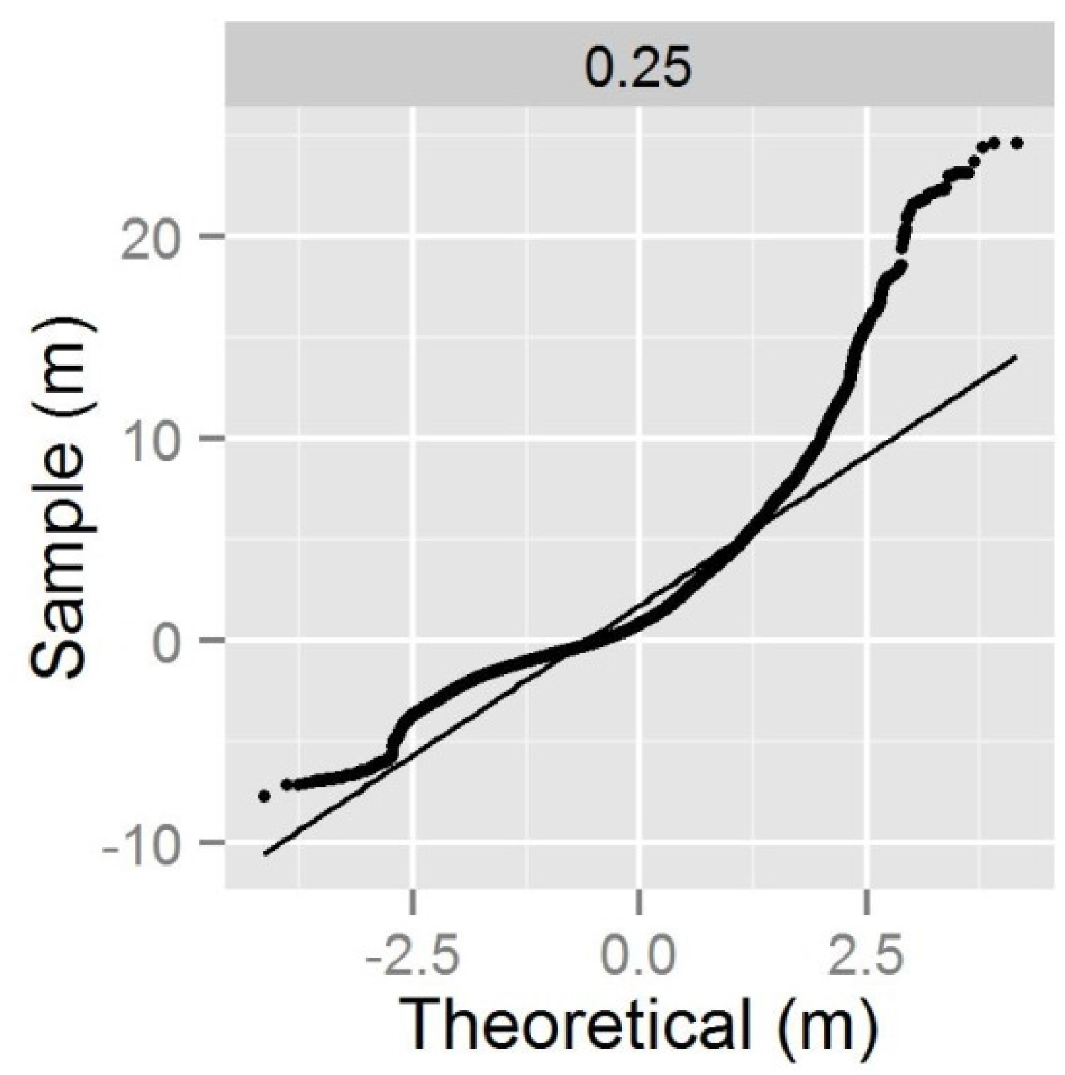
3.1. Effects of Pulse Density on DTM Quality
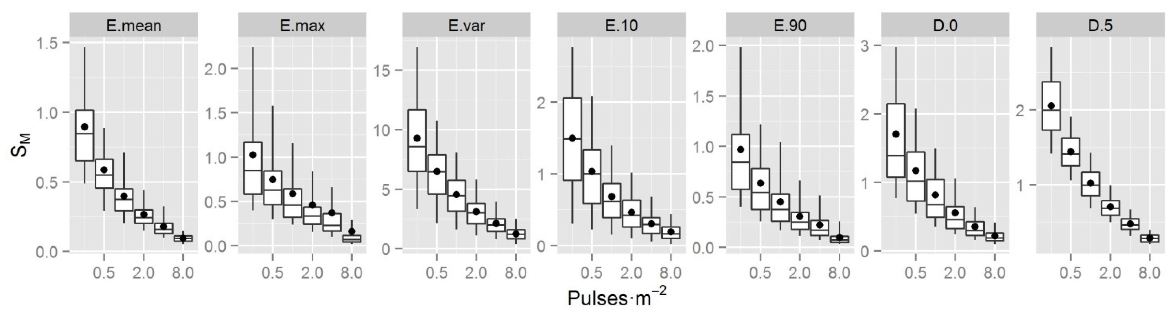
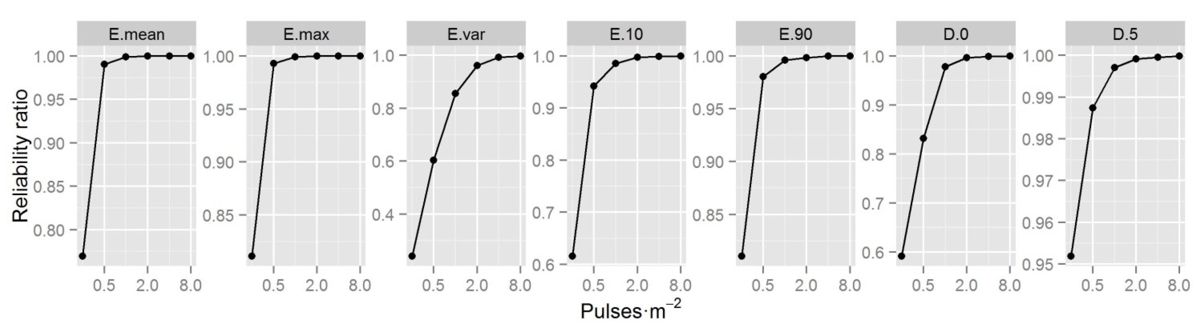
3.2. Effects of Pulse Density on Canopy Metrics

| Plot Size (ha) | Pulse Density | E.mean | E.max | E.var | E.10 | E.90 | D.0 | D.5 |
|---|---|---|---|---|---|---|---|---|
| 0.07 | 0.25 | 24.59 | 41.42 | 107.59 | 10.06 | 36.15 | 89.99 | 55.18 |
| 0.07 | 0.5 | 24.49 | 41.75 | 108.79 | 9.79 | 36.18 | 90.01 | 55.25 |
| 0.07 | 1 | 24.47 | 41.98 | 108.93 | 9.72 | 36.16 | 90.09 | 55.39 |
| 0.07 | 2 | 24.49 | 42.22 | 109.17 | 9.70 | 36.19 | 90.17 | 55.47 |
| 0.07 | 4 | 24.59 | 42.36 | 108.72 | 9.82 | 36.21 | 90.29 | 55.68 |
| 0.07 | 8 | 24.69 | 42.56 | 108.17 | 9.93 | 36.26 | 90.33 | 55.73 |
| 0.14 | 0.25 | 24.59 | 43.44 | 112.27 | 9.48 | 36.64 | 90.07 | 54.67 |
| 0.14 | 0.5 | 24.47 | 43.70 | 113.24 | 9.28 | 36.60 | 90.07 | 54.74 |
| 0.14 | 1 | 24.45 | 43.92 | 113.60 | 9.21 | 36.60 | 90.15 | 54.80 |
| 0.14 | 2 | 24.49 | 44.11 | 113.67 | 9.24 | 36.63 | 90.23 | 54.89 |
| 0.14 | 4 | 24.60 | 44.23 | 113.15 | 9.40 | 36.68 | 90.38 | 55.05 |
| 0.14 | 8 | 24.70 | 44.39 | 112.60 | 9.52 | 36.74 | 90.44 | 55.14 |
| 0.21 | 0.25 | 24.60 | 44.38 | 114.04 | 9.33 | 36.93 | 90.16 | 54.35 |
| 0.21 | 0.5 | 24.47 | 44.61 | 114.91 | 9.12 | 36.86 | 90.14 | 54.42 |
| 0.21 | 1 | 24.43 | 44.81 | 115.22 | 9.04 | 36.84 | 90.18 | 54.50 |
| 0.21 | 2 | 24.49 | 45.03 | 115.35 | 9.07 | 36.88 | 90.28 | 54.59 |
| 0.21 | 4 | 24.59 | 45.17 | 114.83 | 9.22 | 36.93 | 90.40 | 54.72 |
| 0.21 | 8 | 24.70 | 45.33 | 114.22 | 9.35 | 37.00 | 90.48 | 54.82 |
| 0.28 | 0.25 | 24.59 | 45.01 | 115.87 | 9.13 | 37.05 | 90.01 | 54.31 |
| 0.28 | 0.5 | 24.45 | 45.23 | 116.54 | 8.93 | 36.97 | 89.97 | 54.36 |
| 0.28 | 1 | 24.44 | 45.47 | 116.95 | 8.87 | 36.98 | 90.04 | 54.45 |
| 0.28 | 2 | 24.48 | 45.68 | 116.93 | 8.91 | 37.00 | 90.12 | 54.52 |
| 0.28 | 4 | 24.59 | 45.85 | 116.40 | 9.05 | 37.05 | 90.24 | 54.66 |
| 0.28 | 8 | 24.69 | 45.98 | 115.84 | 9.18 | 37.12 | 90.33 | 54.75 |
3.3. Effects of Plot Size on Canopy Metrics
4. Discussion
5. Conclusions
Acknowledgments
Author Contributions
Conflicts of Interest
References
- Grace, J.; Mitchard, E.; Gloor, E. Perturbations in the carbon budget of the tropics. Glob. Change Biol. 2014, 20, 3238–3255. [Google Scholar] [CrossRef] [PubMed]
- UNFCCC. Action taken by the conference of the parties at its sixteenth session. In Proceedings of the Sixteenth Session of the Conference of the Parties, Cancun, Mexico, 29 November–10 December 2010.
- Asner, G.P.; Mascaro, J. Mapping tropical forest carbon: Calibrating plot estimates to a simple LiDAR metric. Remote Sens. Environ. 2014, 140, 614–624. [Google Scholar] [CrossRef]
- Jubanski, J.; Ballhorn, U.; Kronseder, K.; Franke, J.; Siegert, F. Detection of large above ground biomass variability in lowland forest ecosystems by airborne LiDAR. Biogeosciences Discuss. 2012, 9, 11815–11842. [Google Scholar] [CrossRef]
- Vincent, G.; Sabatier, D.; Blanc, L.; Chave, J.; Weissenbacher, E.; Pélissier, R.; Fonty, E.; Molino, J.F.; Couteron, P. Accuracy of small footprint airborne LiDAR in its predictions of tropical moist forest stand structure. Remote Sens. Environ. 2012, 125, 23–33. [Google Scholar] [CrossRef]
- Hou, Z.; Xu, Q.; Tokola, T. Use of ALS, Airborne CIR and ALOS AVNIR-2 data for estimating tropical forest attributes in Lao PDR. ISPRS J. Photogramm. Remote Sens. 2011, 66, 776–786. [Google Scholar] [CrossRef]
- Andersen, H.E.; Reutebuch, S.E.; McGaughey, R.J.; d'Oliveira, M.V.N.; Keller, M. Monitoring selective logging in western Amazonia with repeat LiDAR flights. Remote Sens. Environ. 2013, 151, 157–165. [Google Scholar] [CrossRef]
- Laurin, G.V.; Chen, Q.; Lindsell, J.A.; Coomes, D.A.; Frate, F.D.; Guerriero, L.; Pirotti, F.; Valentini, R. Above ground biomass estimation in an African tropical forest with LiDAR and hyperspectral data. ISPRS J. Photogramm. Remote Sens. 2014, 89, 49–58. [Google Scholar] [CrossRef]
- Asner, G.P.; Powell, G.V.N.; Mascaro, J.; Knapp, D.E.; Clark, J.K.; Jacobson, J.; Kennedy-Bowdoin, T.; Balaji, A.; Paez-Acosta, G.; Victoria, E.; Secada, L.; Valqui, M.; Hughes, R.F. High-resolution forest carbon stocks and emissions in the Amazon. Proc. Natl. Acad. Sci. USA 2010, 107, 16738–16742. [Google Scholar] [CrossRef] [PubMed]
- Ioki, K.; Tsuyuki, S.; Hirata, Y.; Phua, M.H.; Wong, W.V.C.; Ling, Z.Y.; Saito, H.; Takao, G. Estimating above-ground biomass of tropical rainforest of different degradation levels in Northern Borneo using airborne LiDAR. For. Ecol. Manage. 2014, 328, 335–341. [Google Scholar] [CrossRef]
- d'Oliveira, M.V.N.; Reutebuch, S.E.; McGaughey, R.J.; Andersen, H.E. Estimating forest biomass and identifying low-intensity logging areas using airborne scanning LiDAR in Antimary State Forest, Acre State, Western Brazilian Amazon. Remote Sens. Environ. 2012, 124, 479–491. [Google Scholar] [CrossRef]
- Gobakken, T.; Næsset, E. Assessing effects of laser point density, ground sampling intensity, and field sample plot size on biophysical stand properties derived from airborne laser scanner data. Can. J. For. Res. 2008, 38, 1095–1109. [Google Scholar] [CrossRef]
- Holmgren, J. Prediction of tree height, basal area and stem volume in forest stands using airborne laser scanning. Scand. J. Forest Res. 2004, 19, 543–553. [Google Scholar] [CrossRef]
- Maltamo, M.; Eerikainen, K.; Packalen, P.; Hyyppa, J. Estimation of stem volume using laser scanning-based canopy height metrics. Forestry 2006, 79, 217–229. [Google Scholar] [CrossRef]
- Magnusson, M.; Fransson, J.E.S.; Holmgren, J. Effects on estimation accuracy of forest variables using different pulse density of laser data. For. Sci. 2007, 53, 619–626. [Google Scholar]
- Watt, M.; Adams, T.; Gonzalez Aracil, S.; Marshall, H.; Watt, P. The influence of LiDAR pulse density and plot size on the accuracy of New Zealand plantation stand volume equations. J. For. Sci. 2013, 43. [Google Scholar] [CrossRef]
- Vauhkonen, J.; Tokola, T.; Maltamo, M.; Packalen, P. Effects of pulse density on predicting characteristics of individual trees of Scandinavian commercial species using alpha shape metrics based on airborne laser scanning data. Can. J. Remote Sens. 2008, 34, S441–S459. [Google Scholar] [CrossRef]
- Strunk, J.; Temesgen, H.; Andersen, H.E.; Flewelling, J.P.; Madsen, L. Effects of LiDAR pulse density and sample size on a model-assisted approach to estimate forest inventory variables. Can. J. Remote Sens. 2012, 38, 644–654. [Google Scholar] [CrossRef]
- Jakubowski, M.K.; Guo, Q.; Kelly, M. Tradeoffs between LiDAR pulse density and forest measurement accuracy. Remote Sens. Environ. 2013, 130, 245–253. [Google Scholar] [CrossRef]
- Magnussen, S.; Næsset, E.; Gobakken, T. Reliability of LiDAR derived predictors of forest inventory attributes: A case study with Norway spruce. Remote Sens. Environ. 2010, 114, 700–712. [Google Scholar] [CrossRef]
- Ruiz, L.; Hermosilla, T.; Mauro, F.; Godino, M. Analysis of the influence of plot size and LiDAR density on forest structure attribute estimates. Forests 2014, 5, 936–951. [Google Scholar] [CrossRef]
- Leitold, V.; Keller, M.; Morton, D.C.; Cook, B.D.; Shimabukuro, Y.E. Airborne lidar-based estimates of tropical forest structure in complex terrain: opportunities and trade-offs for REDD+. Carbon Balance Manag. 2015, 10. [Google Scholar] [CrossRef] [PubMed]
- Treitz, P.; Lim, K.; Woods, M.; Pitt, D.; Nesbitt, D.; Etheridge, D. LiDAR sampling density for forest resource inventories in Ontario, Canada. Remote Sens. 2012, 4, 830–848. [Google Scholar] [CrossRef]
- National Lidar Dataset. Available online: http://en.wikipedia.org/wiki/National_lidar_dataset (accessed on 25 Febrary 2015).
- Reutebuch, S.E.; McGaughey, R.J.; Andersen, H.E.; Carson, W.W. Accuracy of a high-resolution lidar terrain model under a conifer forest canopy. Can. J. Remote Sens. 2003, 29, 527–535. [Google Scholar] [CrossRef]
- Töyrä, J.; Pietroniro, A.; Hopkinson, C.; Kalbfleisch, W. Assessment of airborne scanning laser altimetry (LiDAR) in a deltaic wetland environment. Can. J. Remote Sens. 2003, 29, 718–728. [Google Scholar] [CrossRef]
- Bowen, Z.H.; Waltermire, R.G. Evaluation of light detection and ranging (LiDAR) for measuring river corridor topography. J. Am. Water Resour. Assoc. 2002, 38, 33–41. [Google Scholar] [CrossRef]
- Hodgson, M.E.; Jensen, J.; Raber, G.; Tullis, J.; Davis, B.A.; Thompson, G.; Schuckman, K. An evaluation of LiDAR-derived elevation and terrain slope in leaf-off conditions. Photogramm. Eng. Remote Sens. 2005, 71, 817–823. [Google Scholar] [CrossRef]
- Tinkham, W.T.; Huang, H.Y.; Smith, A.M.S.; Shrestha, R.; Falkowski, M.J.; Hudak, A.T.; Link, T.E.; Glenn, N.F.; Marks, D.G. A comparison of two open source LiDAR surface classification algorithms. Remote Sens. 2011, 3, 638–649. [Google Scholar] [CrossRef]
- Meng, X.L.; Currit, N.; Zhao, K.G. Ground filtering algorithms for airborne LiDAR data: A review of critical issues. Remote Sen. 2010, 2, 833–860. [Google Scholar] [CrossRef]
- Testprosjekt—Klassifisering av Laserdata. Available online: http://kartverket.no/Documents/Om%20Kartverket/Geovekst/Testprosjekt%20klassifisering%20av%20laserdata_2012.pdf (accessed on 30 June 2015).
- Bater, C.W.; Coops, N.C. Evaluating error associated with LiDAR-derived DEM interpolation. Comput. Geosci. 2009, 35, 289–300. [Google Scholar] [CrossRef]
- Liu, X.; Zhang, Z.; Peterson, J.; Chandra, S. The effects of LiDAR data density on DEM accuracy. In Proceedings of 2007 International Congress on Modeling and Simulation, Christchurch, New Zealand, 31 December 2007.
- Næsset, E. Predicting forest stand characteristics with airborne scanning laser using a practical two-stage procedure and field data. Remote Sens. Environ. 2002, 80, 88–99. [Google Scholar] [CrossRef]
- Næsset, E.; Bollandsås, O.M.; Gobakken, T. Comparing regression methods in estimation of biophysical properties of forest stands from two different inventories using laser scanner data. Remote Sens. Environ. 2005, 94, 541–553. [Google Scholar] [CrossRef]
- Li, Y.Z.; Andersen, H.E.; McGaughey, R. A comparison of statistical methods for estimating forest biomass from light detection and ranging data. West. J. Appl. For. 2008, 23, 223–231. [Google Scholar]
- Fassnacht, F.E.; Hartig, F.; Latifi, H.; Berger, C.; Hernández, J.; Corvalán, P.; Koch, B. Importance of sample size, data type and prediction method for remote sensing-based estimations of aboveground forest biomass. Remote Sens. Environ. 2014, 154, 102–114. [Google Scholar] [CrossRef]
- Asner, G.P. Tropical forest carbon assessment: integrating satellite and airborne mapping approaches. Environ. Res. Lett. 2009, 4. [Google Scholar] [CrossRef]
- Mascaro, J.; Detto, M.; Asner, G.P.; Muller-Landau, H.C. Evaluating uncertainty in mapping forest carbon with airborne LiDAR. Remote Sens. Environ. 2011, 115, 3770–3774. [Google Scholar] [CrossRef]
- Asner, G.P.; Knapp, D.E.; Martin, R.E.; Tupayachi, R.; Anderson, C.B.; Mascaro, J.; Sinca, F.; Chadwick, K.D.; Higgins, M.; Farfan, W.; Llactayo, W.; Silman, M.R. Targeted carbon conservation at national scales with high-resolution monitoring. Proc. Natl. Acad. Sci. 2014, 111, E5016–E5022. [Google Scholar] [CrossRef] [PubMed]
- Hernández-Stefanoni, J.; Dupuy, J.; Johnson, K.; Birdsey, R.; Tun-Dzul, F.; Peduzzi, A.; Caamal-Sosa, J.; Sánchez-Santos, G.; López-Merlín, D. Improving species diversity and biomass estimates of tropical dry forests using airborne LiDAR. Remote Sens. 2014, 6, 4741–4763. [Google Scholar] [CrossRef]
- Mauya, E.W.; Hansen, E.H.; Gobakken, T.; Bollandsas, O.M.; Malimbwi, R.E.; Næsset, E. Effects of field plot size on prediction accuracy of aboveground biomass in airborne laser scanning-assisted inventories in tropical rain forests of Tanzania. Carbon Balance Manag. 2015, 10. [Google Scholar] [CrossRef] [PubMed]
- Vauhkonen, J.; Maltamo, M.; McRoberts, R.; Næsset, E. Introduction to forestry applications of airborne laser scanning. In Forestry Applications of Airborne Laser Scanning; Maltamo, M., Næsset, E., Vauhkonen, J., Eds.; Springer Netherlands: Dordrecht, Netherlands, 2014; Vol. 27, pp. 1–16. [Google Scholar]
- Zolkos, S.G.; Goetz, S.J.; Dubayah, R. A meta-analysis of terrestrial aboveground biomass estimation using LiDAR remote sensing. Remote Sens. Environ. 2013, 128, 289–298. [Google Scholar] [CrossRef]
- Tomppo, E.; Malimbwi, R.; Katila, M.; Mäkisara, K.; Henttonen, H.M.; Chamuya, N.; Zahabu, E.; Otieno, J. A sampling design for a large area forest inventory: case Tanzania. Can. J. For. Res. 2014, 44, 931–948. [Google Scholar] [CrossRef]
- Hamilton, A.C.; Bensted-Smith, R. Forest Conservation in the East Usambara Mountains, Tanzania; International Union for Conservation of Nature: Gland, Switzerland.
- Kouba, J. A Guide to Using International GNSS Service (IGS) Products. Available online: https://igscb.jpl.nasa.gov/components/usage.html (accessed on 30 June 2015).
- Pinnacle User’s Manual. Available online: http://folk.uio.no/treiken/GEO4530/pinnacle.pdf (accessed on 30 June 2015).
- Hansen, E.; Gobakken, T.; Bollandsås, O.; Zahabu, E.; Næsset, E. Modeling aboveground biomass in dense tropical submontane rainforest using airborne laser scanner data. Remote Sens. 2015, 7, 788–807. [Google Scholar] [CrossRef]
- McGaughey, R.J. FUSION/LDV: Software for LiDAR Data Analysis and Visualization. Avalable online: http://forsys.cfr.washington.edu/fusion/FUSION_manual.pdf (accessed on 30 June 2015).
- Kraus, K.; Pfeifer, N. Determination of terrain models in wooded areas with airborne laser scanner data. ISPRS J. Photogramm. Remote Sens. 1998, 53, 193–203. [Google Scholar] [CrossRef]
- Holm, S. A simple sequentially rejective multiple test procedure. Scand. J. Stat. 1979, 6, 65–70. [Google Scholar]
- Zandbergen, P.A. Positional accuracy of spatial data: Non-normal distributions and a critique of the national standard for spatial data accuracy. Trans. GIS 2008, 12, 103–130. [Google Scholar] [CrossRef]
- Höhle, J.; Höhle, M. Accuracy assessment of digital elevation models by means of robust statistical methods. ISPRS J. Photogramm. Remote Sens. 2009, 64, 398–406. [Google Scholar] [CrossRef]
- Lim, K.; Hopkinson, C.; Treitz, P. Examining the effects of sampling point densities on laser canopy height and density metrics. For. Chron. 2008, 84, 876–885. [Google Scholar] [CrossRef]
- Fuller, W.A. Measurement Error Models; John Wiley and Sons: New York, NY, USA, 1987; p. 440. [Google Scholar]
- Anderson, E.S.; Thompson, J.A.; Crouse, D.A.; Austin, R.E. Horizontal resolution and data density effects on remotely sensed LiDAR-based DEM. Geoderma 2006, 132, 406–415. [Google Scholar] [CrossRef]
- Hyyppä, J.; Yu, X.; Hyyppä, H.; Kaartinen, H.; Honkavara, E.; Rönnholm, P. Factors affecting the quality of DTM generation in forested areas. In Proceedings of 2005 ISPRS Workshop on Laser Scanning, Enschede, Netherlands, 12–14 September 2005.
- Zhang, K.; Chen, S.C.; Whitman, D.; Shyu, M.L.; Yan, J.; Zhang, C. A progressive morphological filter for removing nonground measurements from airborne LiDAR data. IEEE Trans. Geosci. Remote Sens. 2003, 41, 872–882. [Google Scholar] [CrossRef]
- Valbuena, R.; Mauro, F.; Rodriguez-Solano, R.; Antonio Manzanera, J. Partial least squares for discriminating variance components in global navigation satellite systems accuracy obtained under scots pine canopies. For. Sci. 2012, 58, 139–153. [Google Scholar] [CrossRef]
- Nyström, M.; Holmgren, J.; Olsson, H. Prediction of tree biomass in the forest-tundra ecotone using airborne laser scanning. Remote Sens. Environ. 2012, 123, 271–279. [Google Scholar] [CrossRef]
- Andersen, H.-E.; Reutebuch, S.E.; McGaughey, R.J. A rigorous assessment of tree height measurements obtained using airborne LiDAR and conventional field methods. Can. J. Remote Sens. 2006, 32, 355–366. [Google Scholar] [CrossRef]
- Goodwin, N.R.; Coops, N.C.; Culvenor, D.S. Assessment of forest structure with airborne LiDAR and the effects of platform altitude. Remote Sens. Environ. 2006, 103, 140–152. [Google Scholar] [CrossRef]
© 2015 by the authors; licensee MDPI, Basel, Switzerland. This article is an open access article distributed under the terms and conditions of the Creative Commons Attribution license (http://creativecommons.org/licenses/by/4.0/).
Share and Cite
Hansen, E.H.; Gobakken, T.; Næsset, E. Effects of Pulse Density on Digital Terrain Models and Canopy Metrics Using Airborne Laser Scanning in a Tropical Rainforest. Remote Sens. 2015, 7, 8453-8468. https://doi.org/10.3390/rs70708453
Hansen EH, Gobakken T, Næsset E. Effects of Pulse Density on Digital Terrain Models and Canopy Metrics Using Airborne Laser Scanning in a Tropical Rainforest. Remote Sensing. 2015; 7(7):8453-8468. https://doi.org/10.3390/rs70708453
Chicago/Turabian StyleHansen, Endre Hofstad, Terje Gobakken, and Erik Næsset. 2015. "Effects of Pulse Density on Digital Terrain Models and Canopy Metrics Using Airborne Laser Scanning in a Tropical Rainforest" Remote Sensing 7, no. 7: 8453-8468. https://doi.org/10.3390/rs70708453
APA StyleHansen, E. H., Gobakken, T., & Næsset, E. (2015). Effects of Pulse Density on Digital Terrain Models and Canopy Metrics Using Airborne Laser Scanning in a Tropical Rainforest. Remote Sensing, 7(7), 8453-8468. https://doi.org/10.3390/rs70708453