
Mapping Deciduous Rubber Plantation Areas and Stand Ages with PALSAR and Landsat Images


 , ,
, , 
Abstract
:
1. Introduction
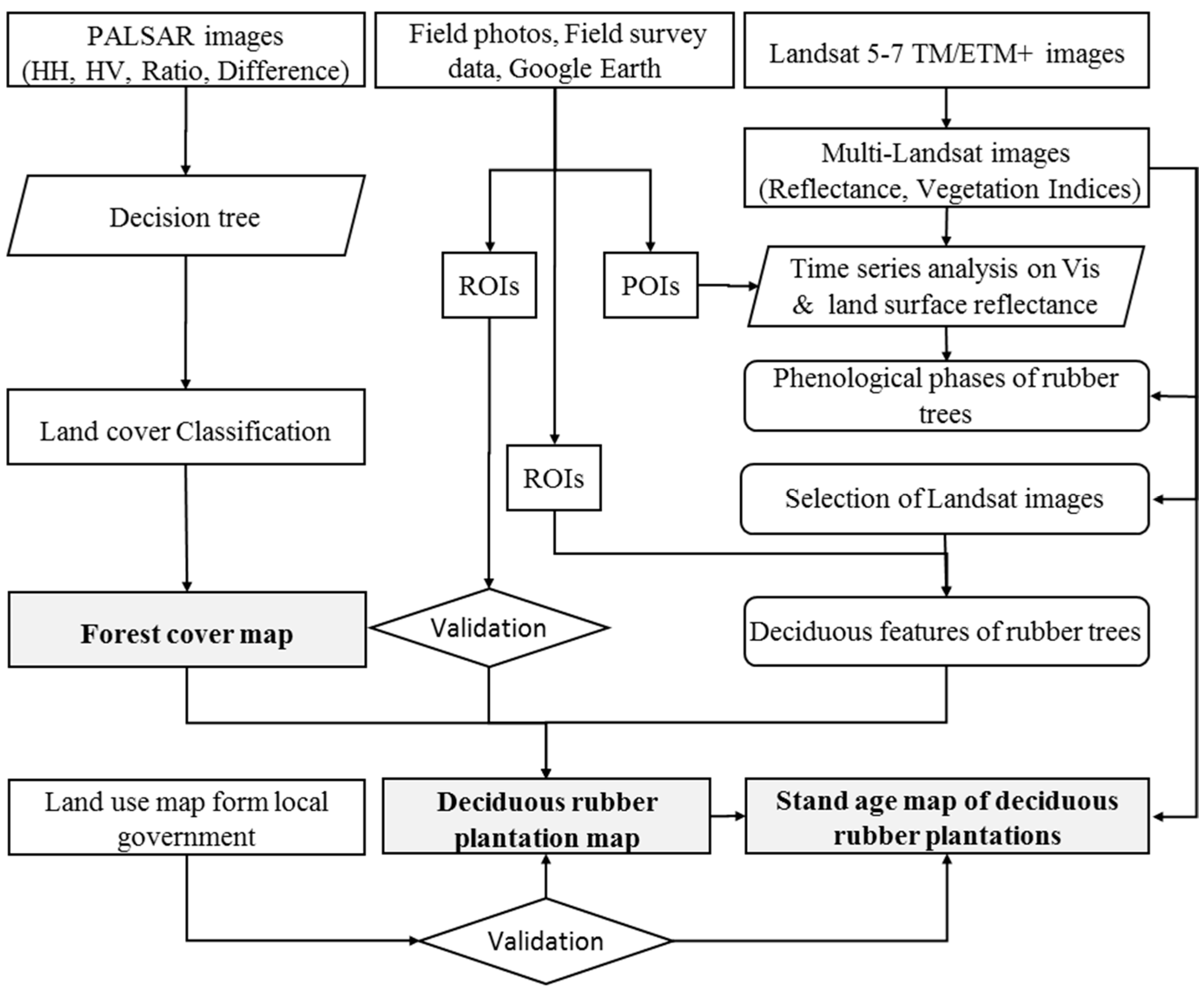
2. Materials and Methods
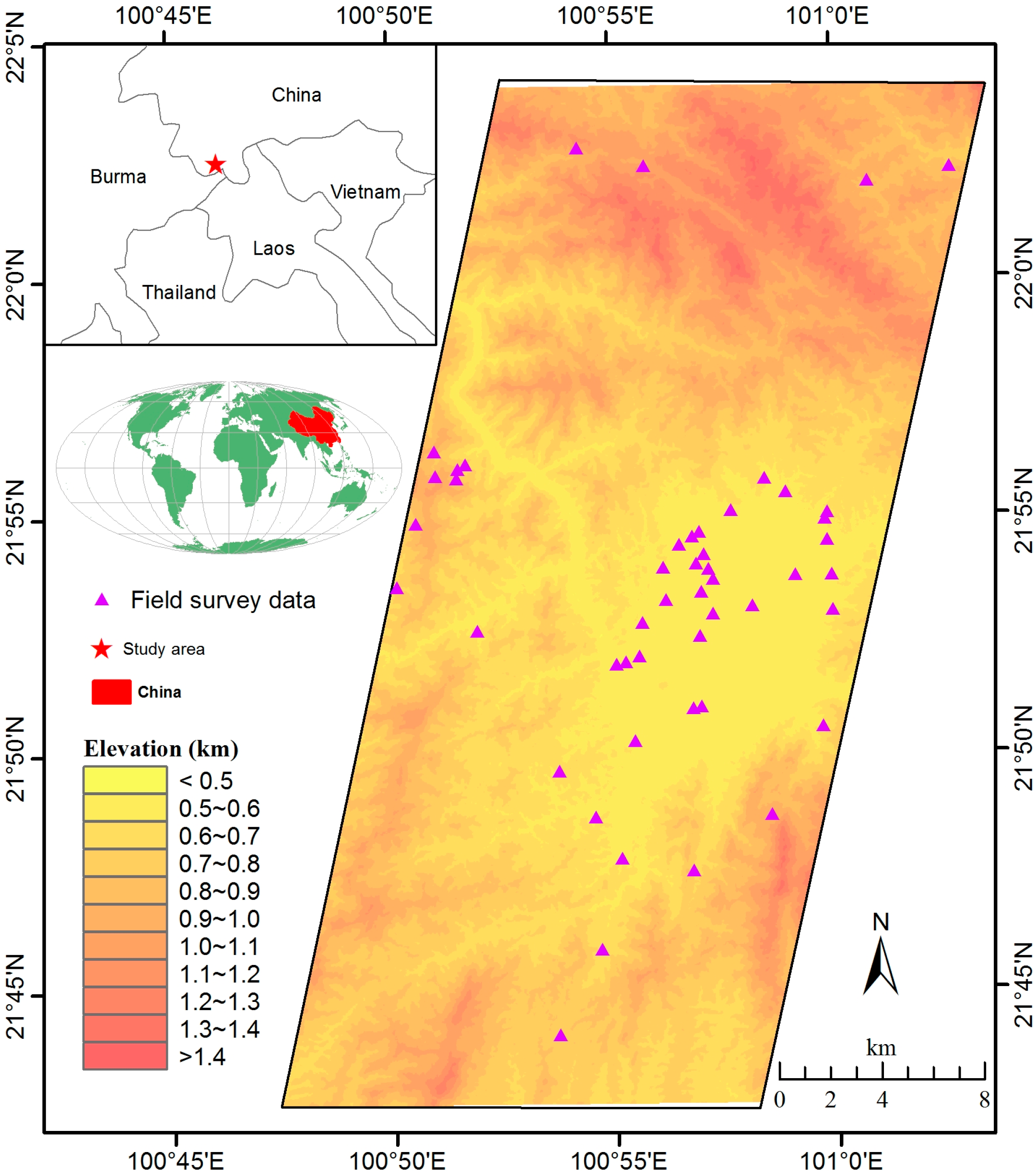
2.1. Study Area
2.2. Data Pre-Processing
2.2.1. PALSAR Data and Pre-Processing
2.2.2. Landsat Data and Pre-Processing


| Year | Landsat 5 | Landsat TM/ETM+ 7 | Total |
|---|---|---|---|
| 2000 | 12 | 8 | 20 |
| 2001 | 13 | 8 | 21 |
| 2002 | 11 | 6 | 17 |
| 2003 | 17 | 7 | 24 |
| 2004 | 15 | 8 | 23 |
| 2005 | 2 | 11 | 13 |
| 2006 | 1 | 14 | 15 |
| 2007 | 2 | 12 | 14 |
| 2008 | 0 | 14 | 14 |
| 2009 | 6 | 12 | 18 |
| 2010 | 2 | 14 | 16 |
| 2011 | 2 | 11 | 13 |
| 2012 | 0 | 18 | 18 |
| Total | 83 | 143 | 226 |
2.3. Ground Reference Data for Algorithm Training and Product Validation
2.3.1. Geo-Referenced Field Photos (Points of Interest)
2.3.2. Regions of Interest (ROIs) for Algorithm Training and Product Validation
| ID | Land Cover Types | Pixels | Sources | Uses |
|---|---|---|---|---|
| 1 | Natural forest | 845 | Google Earth | Algorithm training |
| Rubber | 1016 | |||
| 2 | Natural forest | 8245 | Google Earth | Validation of PALSAR forest/non forest map |
| Non-forest | 1878 | |||
| 3 | Rubber | 7118 | Google Earth | Validation of resultant rubber plantation map |
| Natural forest | 2814 | |||
| Non-forest | 2974 | |||
| 4 | ≤5 year-old rubber | 4260 | Survey data | Validation of rubber stand age map |
| 6–10 year-old rubber | 4425 | |||
| >10 year-old rubber | 3647 |
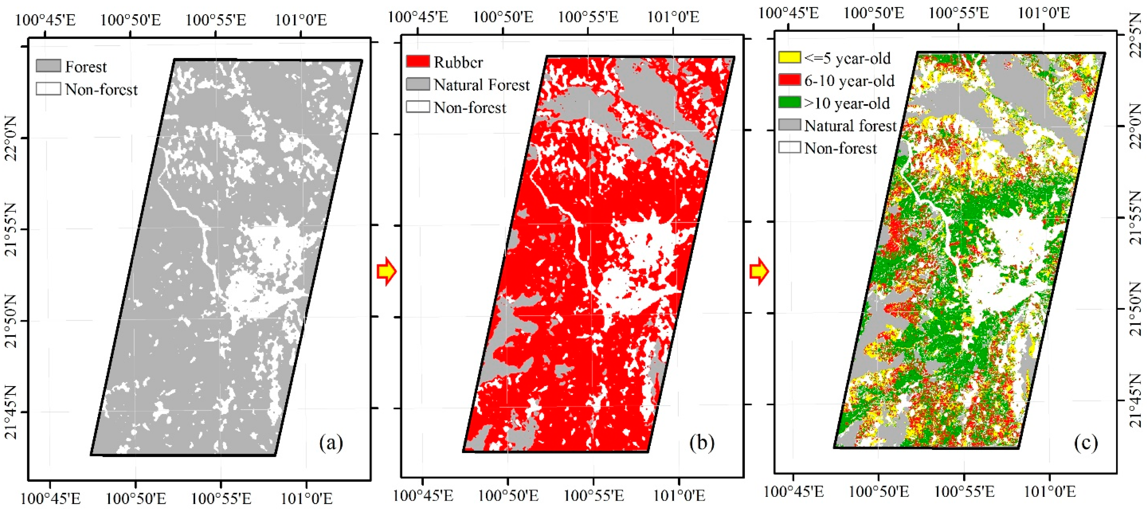
2.4. Map of Forest Cover in 2009 from PALSAR Imagery
2.5. Map of Deciduous Rubber Plantations for 2009 through Integrating PALSAR and Landsat Images
2.6. Map of Stand Age of Deciduous Rubber Plantations
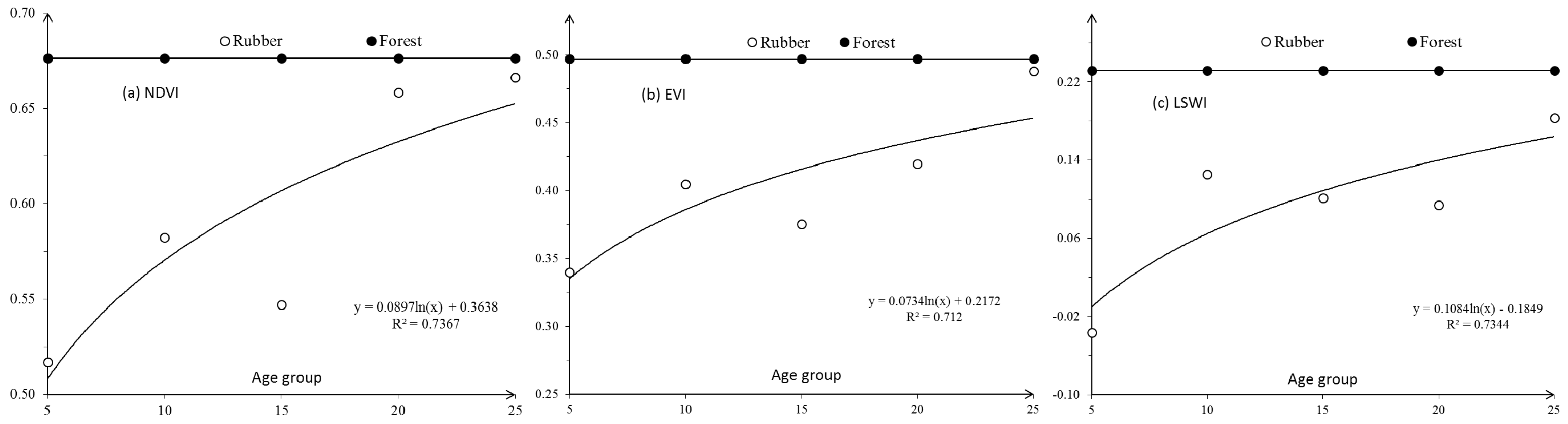
2.6.1. Landsat-Based Signature Analysis of Rubber Plantations with Different Stand Ages
2.6.2. Map of Deciduous Rubber Plantations with Different Stand Ages
2.7. Validation and Comparison
3. Results
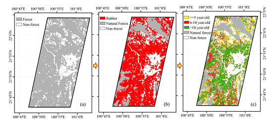
3.1. Map of Forest Cover from PALSAR Imagery in 2009
| Class | Ground Truth (Pixels) | Total Classified Pixels | User’s Accuracy | ||
|---|---|---|---|---|---|
| Forest | Non-Forest | ||||
| Classified results | Forest | 7917 | 328 | 8245 | 96% |
| Non-forest | 174 | 1704 | 1878 | 91% | |
| Total ground truth pixels | 8091 | 2032 | 10,123 | - | |
| Producer’s accuracy | 98% | 84% | - | 95% | |
3.2. Map of Rubber Plantations in 2009
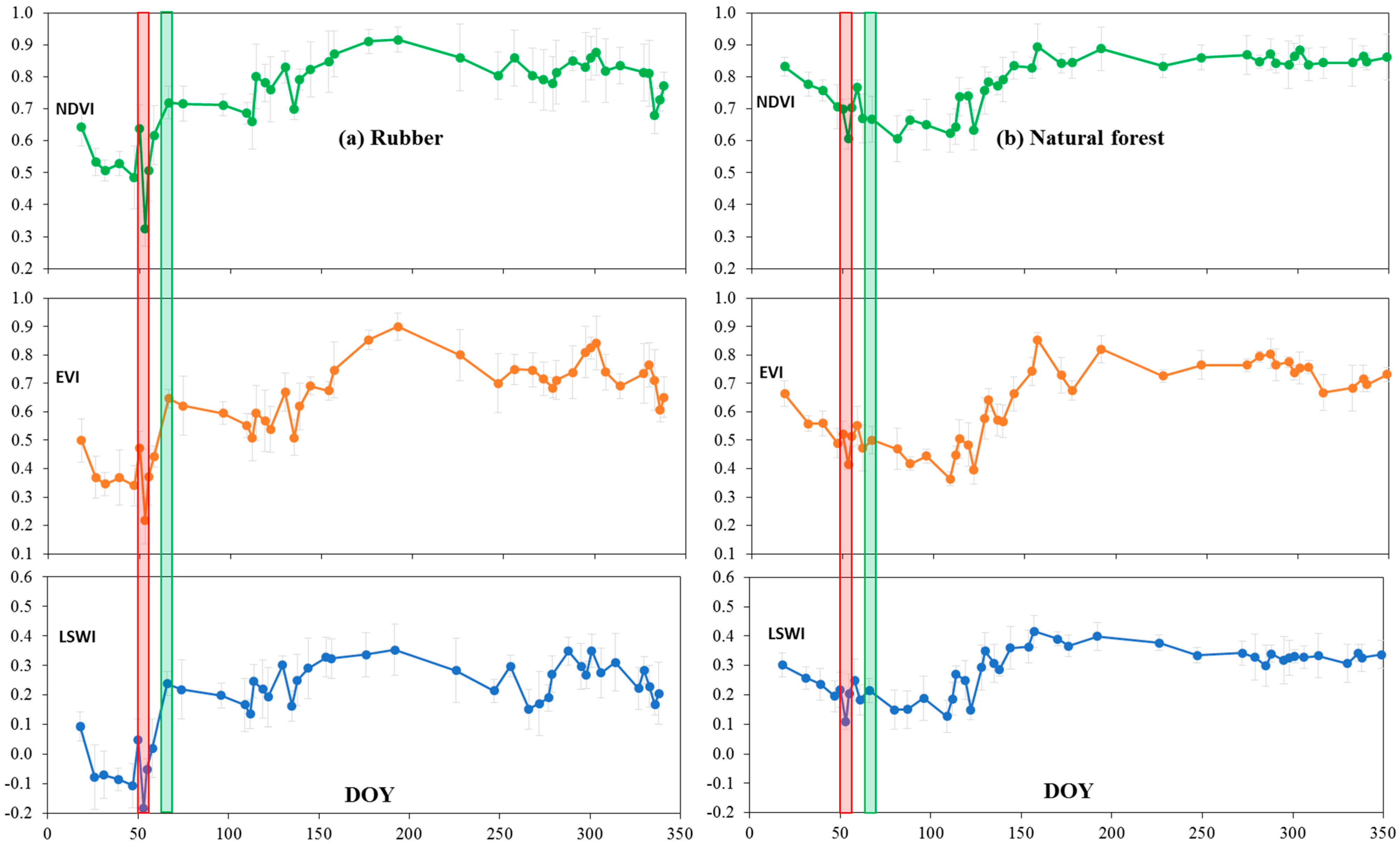
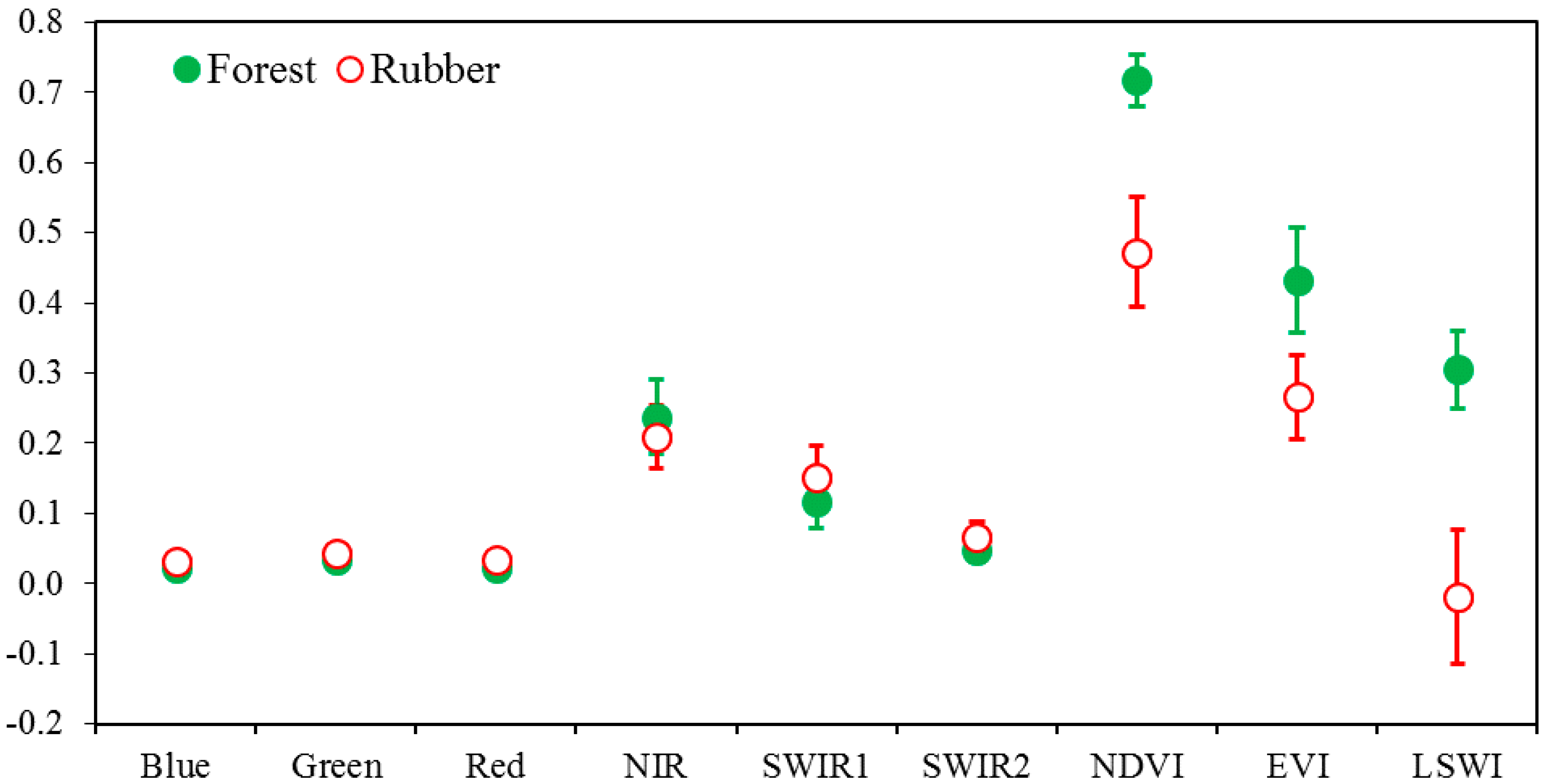
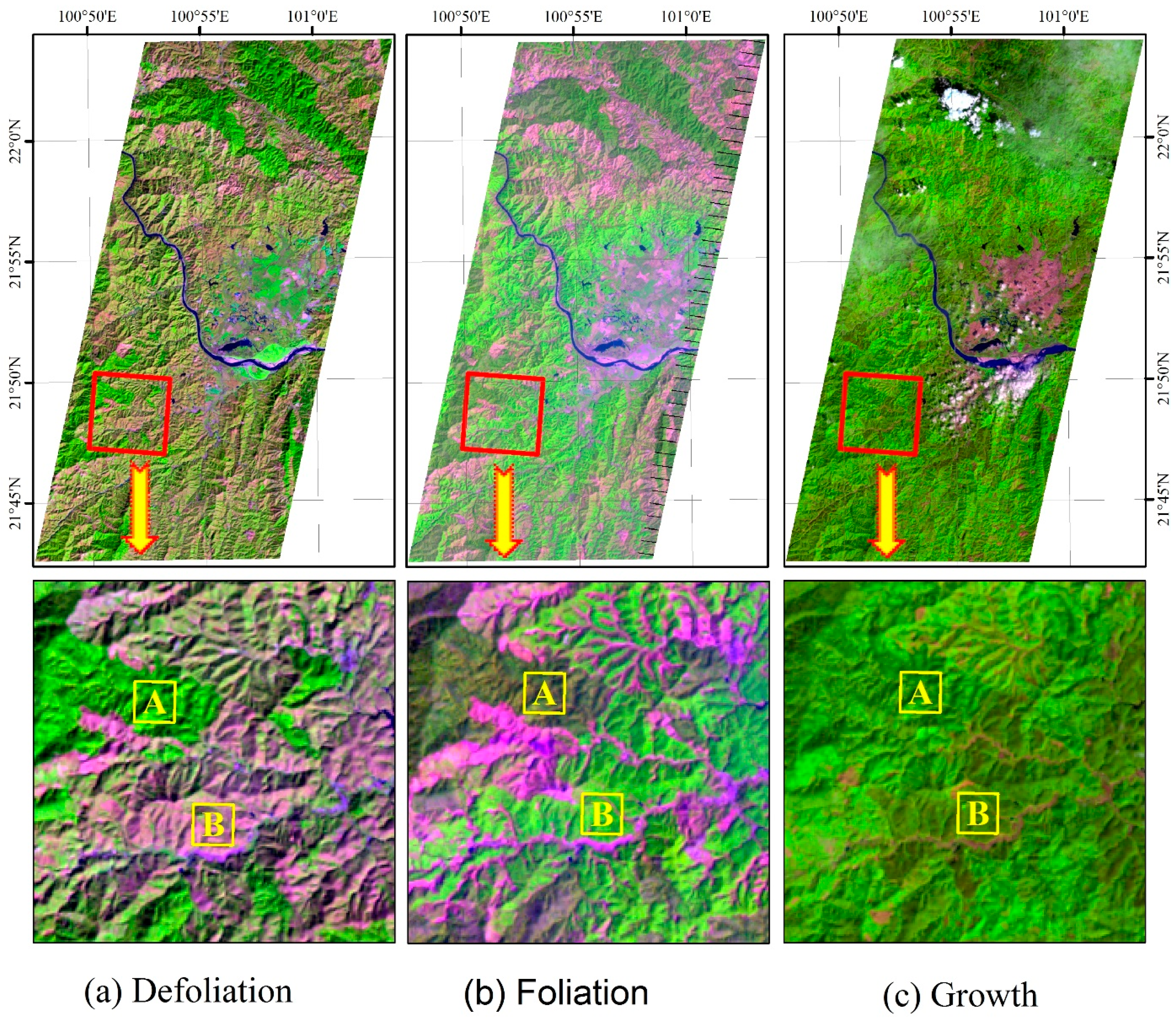
3.2.1. Seasonal Phenology of Deciduous Rubber Plantations in 2009 from Landsat


3.2.2. Map of Deciduous Rubber Plantations from PALSAR and Landsat in 2009
| Class | Ground Truth (Pixels) | Total Classified Pixels | User’s Accuracy | |||
|---|---|---|---|---|---|---|
| Rubber | Natural Forest | Non-Forest | ||||
| Classified results | Rubber | 6480 | 37 | 601 | 7118 | 91% |
| Natural Forest | 21 | 2780 | 13 | 2814 | 99% | |
| Non-forest | 359 | 6 | 2609 | 2974 | 88% | |
| Total ground truth pixels | 6860 | 2823 | 3223 | 12906 | ||
| Producer’s accuracy | 94% | 98% | 81% | - | - | |
3.3. Map of Stand Ages of Rubber Plantations in 2009
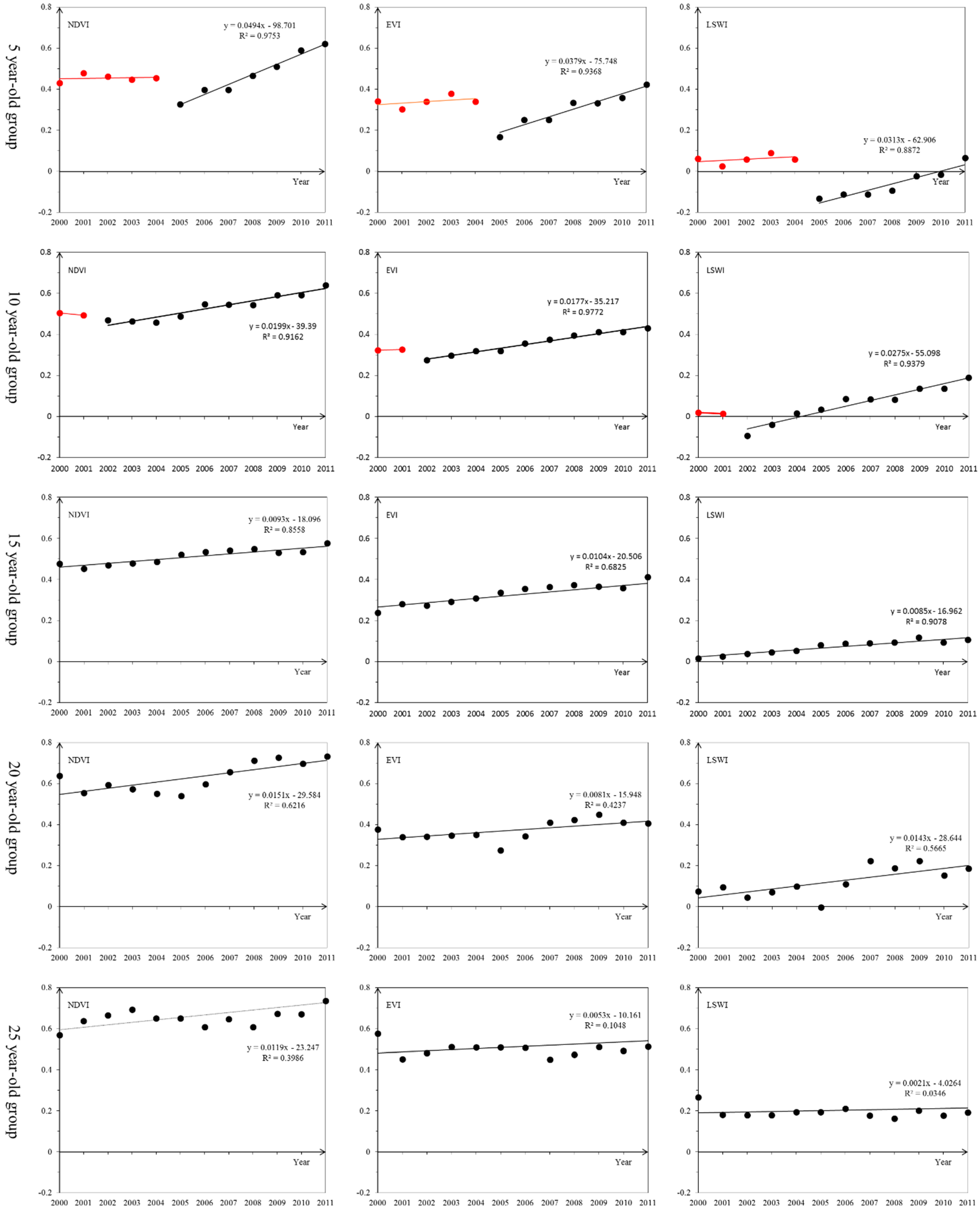
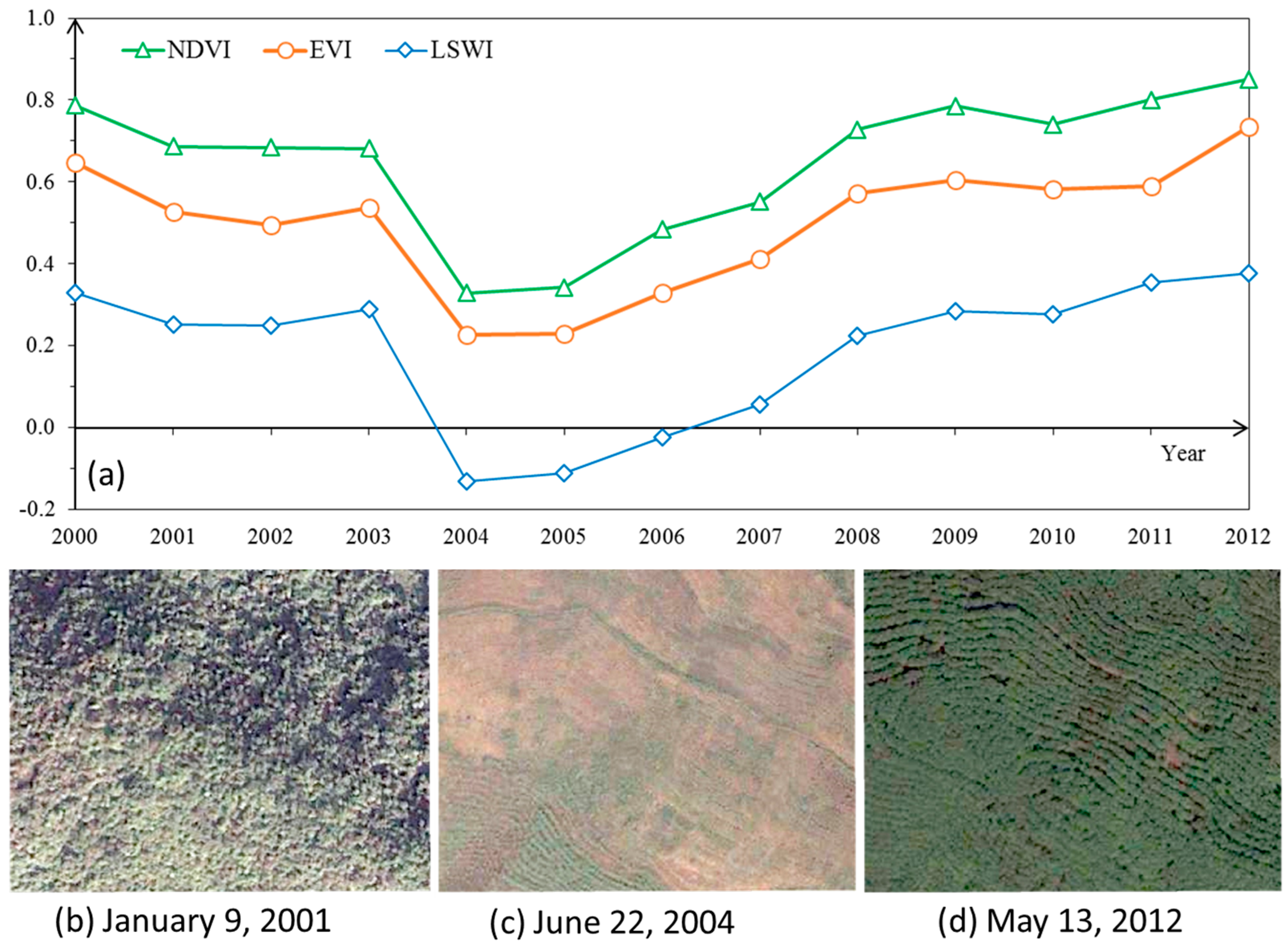
3.3.1. Changes in Seasonal Phenology of Deciduous Rubber Plantations at Different Stand Ages from Landsat iMages in 2000–2011


3.3.2. Map of Stand Age of Deciduous Rubber Plantations in 2009
| Class (year-old) | Ground Truth (Pixels) | Total Classified Pixels | User’s Accuracy | |||
|---|---|---|---|---|---|---|
| <6 | 6–10 | >10 | ||||
| Classified results | <6 | 3763 | 388 | 109 | 4260 | 88% |
| 6–10 | 373 | 3843 | 209 | 4425 | 87% | |
| >10 | 180 | 540 | 2927 | 3647 | 80% | |
| Total ground truth pixels | 4316 | 4771 | 3245 | 12332 | ||
| Producer’s accuracy | 87% | 81% | 90% | |||
4. Discussions
4.1. Major Findings and Potentials for Mapping Forest, Rubber Plantations, and Their Stand Ages
4.2. Sources of Errors and Uncertainties in Mapping of Forest, Rubber Plantations, and Stand Ages
4.3. Field Survey Data and High Resolution Images
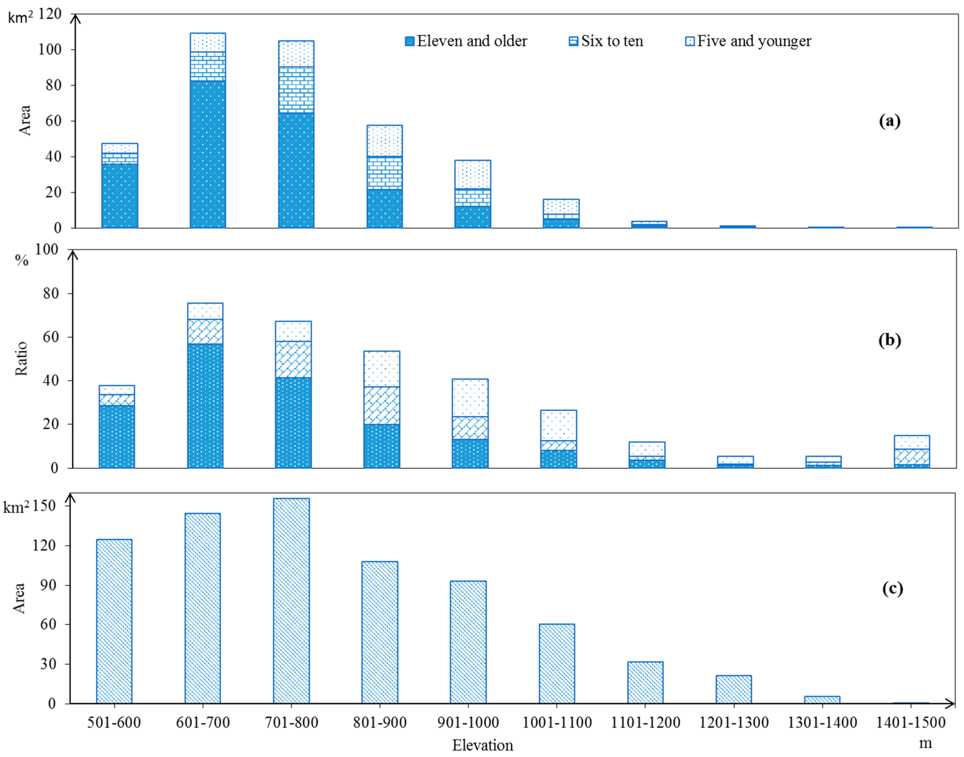
4.4. Implications for the Expansion of Rubber Plantations in Xishuangbanna
5. Conclusions
Acknowledgments
Author Contributions
Conflicts of Interest
References
- FAO. Global Forest Resources Assessment 2010. Available online: http://www.fao.org/docrep/013/i1757e/i1757e.pdf (accessed on 10 September 2014).
- Fox, J.; Castella, J.-C. Expansion of rubber (Hevea brasiliensis) in mainland Southeast Asia: What are the prospects for smallholders? J. Peasant Stud. 2013, 40, 155–170. [Google Scholar] [CrossRef]
- Ziegler, A.D.; Fox, J.M.; Xu, J.C. The rubber juggernaut. Science 2009, 324, 1024–1025. [Google Scholar] [CrossRef] [PubMed]
- Li, H.; Aide, T.M.; Ma, Y.; Liu, W.; Cao, M. Demand for rubber is causing the loss of high diversity rain forest in SW China. Biodivers. Conserv. 2007, 16, 1731–1745. [Google Scholar] [CrossRef]
- Qiu, J. Where the rubber meets the garden. Nature 2009, 457, 246–247. [Google Scholar] [CrossRef] [PubMed]
- Yi, Z.-F.; Cannon, C.H.; Chen, J.; Ye, C.-X.; Swetnam, R.D. Developing indicators of economic value and biodiversity loss for rubber plantations in Xishuangbanna, Southwest China: A case study from Menglun township. Ecol. Indic. 2014, 36, 788–797. [Google Scholar] [CrossRef]
- Li, Z.; Fox, J.M. Mapping rubber tree growth in mainland southeast Asia using time-series MODIS 250 m NDVI and statistical data. Appl. Geogr. 2012, 32, 420–432. [Google Scholar] [CrossRef]
- Li, Y.; Liu, G.; Huang, C. Analysis of distribution characteristics of Hevea brasiliensis in the Xishuangbanna area based on HJ-1 satellite data. Sci. China Inform. Sci. 2011, 41, 166–176. [Google Scholar]
- Liu, X.; Feng, Z.; Jiang, L.; Jiang, Y. Rubber plantations in Xishuangbanna: Remote sensing identification and digital mapping. Resour. Sci. 2012, 34, 1769–1780. [Google Scholar]
- Li, Z.; Fox, J.M. Integrating Mahalanobis typicalities with a neural network for rubber distribution mapping. Remote Sens. Lett. 2011, 2, 157–166. [Google Scholar] [CrossRef]
- Li, Z. Rubber tree distribution mapping in Northeast Thailand. Int. J. Geosci. 2011, 2, 573–584. [Google Scholar] [CrossRef]
- Santoro, M.; Fransson, J.E.S.; Eriksson, L.E.B.; Magnusson, M.; Ulander, L.M.H.; Olsson, H. Signatures of ALOS PALSAR l-band backscatter in Swedish forest. IEEE Trans. Geosci. Remote Sens. 2009, 47, 4001–4019. [Google Scholar] [CrossRef]
- DeFries, R.; Achard, F.; Brown, S.; Herold, M.; Murdiyarso, D.; Schlamadinger, B.; de Souza, C., Jr. Earth observations for estimating greenhouse gas emissions from deforestation in developing countries. Environ. Sci. Policy 2007, 10, 385–394. [Google Scholar] [CrossRef]
- Hansen, M.C.; Roy, D.P.; Lindquist, E.; Adusei, B.; Justice, C.O.; Altstatt, A. A method for integrating MODIS and Landsat data for systematic monitoring of forest cover and change in the Congo basin. Remote Sens. Environ. 2008, 112, 2495–2513. [Google Scholar] [CrossRef]
- Walker, W.S.; Stickler, C.M.; Kellndorfer, J.M.; Kirsch, K.M.; Nepstad, D.C. Large-area classification and mapping of forest and land cover in the Brazilian Amazon: A comparative analysis of ALOS/PALSAR and Landsat data sources. IEEE J. Sel. Top. Appl. Earth Obs. Remote Sens. 2010, 3, 594–604. [Google Scholar] [CrossRef]
- Asner, G.P. Cloud cover in Landsat observations of the Brazilian Amazon. Int. J. Remote Sens. 2001, 22, 3855–3862. [Google Scholar] [CrossRef]
- Baghdadi, N.; Boyer, N.; Todoroff, P.; Hajj, E.M.; Begue, A. Potential of SAR sensors TerraSAR-X, ASAR/ENVISAT and PALSAR/ALOS for monitoring sugarcane crops on Reunion Island. Remote Sens. Environ. 2009, 113, 1724–1738. [Google Scholar] [CrossRef]
- Dong, J.; Xiao, X.; Sheldon, S.; Biradar, C.; Zhang, G.; Duong, N.D.; Hazarika, M.; Wikantika, K.; Takeuhci, W.; Moore, B., III. A 50-m forest cover map in Southeast Asia from ALOS/PALSAR and its application on forest fragmentation assessment. PLoS One 2014, 9. [Google Scholar] [CrossRef] [PubMed]
- Lucas, R.M.; Clewley, D.; Accad, A.; Butler, D.; Armston, J.; Bowen, M.; Bunting, P.; Carreiras, J.; Dwyer, J.; Eyre, T.; et al. Mapping forest growth and degradation stage in the Brigalow Belt Bioregion of Australia through integration of ALOS PALSAR and Landsat-derived foliage projective cover data. Remote Sens. Environ. 2014, 155, 42–57. [Google Scholar] [CrossRef]
- Shimada, M.; Itoh, T.; Motooka, T.; Watanabe, M.; Shiraishi, T.; Thapa, R.; Lucas, R. New global forest/non-forest maps from ALOS PALSAR data (2007–2010). Remote Sens. Environ. 2014, 155, 13–31. [Google Scholar] [CrossRef]
- Dong, J.; Xiao, X.; Sheldon, S.; Biradar, C.; Duong, N.D.; Hazarika, M. A comparison of forest cover maps in mainland Southeast Asia from multiple sources: PALSAR, MERIS, MODIS and FRA. Remote Sens. Environ. 2012, 127, 60–73. [Google Scholar] [CrossRef]
- Yu, L.; Zhu, Y.; Lu, W.; Li, X.; Zhao, Z.; Li, C. Rubber planting area extraction in Xishuangbanna region based on HJ-1 CCD remote sensing image. Chin. J. Agrometeorol. 2013, 34, 493–497. (In Chinese) [Google Scholar]
- Dong, J.; Xiao, X.; Chen, B.; Torbick, N.; Jin, C.; Zhang, G.; Biradar, C. Mapping deciduous rubber plantations through integration of PALSAR and multi-temporal Landsat imagery. Remote Sens. Environ. 2013, 134, 392–402. [Google Scholar] [CrossRef]
- Sheldon, S.; Xiao, X.; Biradar, C. Mapping evergreen forests in the Brazilian Amazon using MODIS and PALSAR 500-m mosaic imagery. ISPRS J. Photogramm. Remote Sens. 2012, 74, 34–40. [Google Scholar] [CrossRef]
- Dong, J.; Xiao, X.; Sheldon, S.; Biradar, C.; Xie, G. Mapping tropical forests and rubber plantations in complex landscapes by integrating PALSAR and MODIS imagery. ISPRS J. Photogramm. Remote Sens. 2012, 74, 20–33. [Google Scholar] [CrossRef]
- Suratman, M.N.; Bull, G.Q.; Leckie, D.G.; Lemay, V.M.; Marshall, P.L.; Mispan, M.R. Prediction models for estimating the area, volume, and age of rubber (Hevea brasiliensis) plantations in Malaysia using Landsat TM data. Int. Forestry Rev. 2004, 6, 1–12. [Google Scholar] [CrossRef]
- Deng, F.; Chen, J.M.; Pan, Y.; Peters, W.; Birdsey, R.; McCullough, K.; Xiao, J. The use of forest stand age information in an atmospheric CO2 inversion applied to North America. Biogeosciences 2013, 10, 5335–5348. [Google Scholar] [CrossRef]
- Deng, F.; Chen, J.M.; Pan, Y.; Peters, W.; Birdsey, R.; McCullough, K.; Xiao, J. Forest stand age information improves an inverse North American carbon flux estimate. Biogeosci. Discuss. 2013, 10, 4781–4817. [Google Scholar] [CrossRef]
- Liu, Y.; Yu, G.; Wang, Q.; Zhang, Y. How temperature, precipitation and stand age control the biomass carbon density of global mature forests. Glob. Ecol. Biogeogr. 2014, 23, 323–333. [Google Scholar] [CrossRef]
- Pretzsch, H.; Biber, P.; Schütze, G.; Bielak, K. Changes of forest stand dynamics in Europe: Facts from long-term observational plots and their relevance for forest ecology and management. Forest Ecol. Manag. 2014, 316, 65–77. [Google Scholar] [CrossRef]
- Yu, G.; Chen, Z.; Piao, S.; Peng, C.; Ciais, P.; Wang, Q.; Li, X.; Zhu, X. High carbon dioxide uptake by subtropical forest ecosystems in the East Asian monsoon region. Proc. Natl. Acad. Sci. USA 2014, 111, 4910–4915. [Google Scholar] [CrossRef] [PubMed]
- Sivanpillai, R.; Smith, C.T.; Srinivasan, R.; Messina, M.G.; Wu, X.B. Estimation of managed loblolly pine stand age and density with Landsat ETM+ data. Forest Ecol. Manag. 2006, 223, 247–254. [Google Scholar] [CrossRef]
- Chen, B.; Cao, J.; Wang, J.; Wu, Z.; Tao, Z.; Chen, J.; Yang, C.; Xie, G. Estimation of rubber stand age in typhoon and chilling injury afflicted area with Landsat TM data: A case study in Hainan Island, China. Forest Ecol. Manag. 2012, 274, 222–230. [Google Scholar] [CrossRef]
- Wu, Z.; Xie, G.; Tao, Z.; Zhou, Z.; Wang, X. Characteristics of soil carbon and total nitrogen contents of rubber plantations at different age stages in Danzhou, Hainan Island. Ecol. Environ. Sci. 2009, 18, 1484–1491. [Google Scholar]
- Liu, X.; Feng, Z.; Jiang, L.; Li, P.; Liao, C.; Yang, Y.; You, Z. Rubber plantation and its relationship with topographical factors in the border region of China, Laos and Myanmar. J. Geogr. Sci. 2013, 23, 1019–1040. [Google Scholar] [CrossRef]
- Lu, H.; Liu, W.; Luo, Q. Ecohydrological effects of litter layer in a mountainous rubber plantation in Xishuangbanna, Southwest China. Chin. J. Ecol. 2011, 30, 2129–2136. (In Chinese) [Google Scholar]
- Japan Aerospace Exploration Agency (JAXA), K&C Mosaic Homepage—PALSAR 50 m Orthorectified Mosaic Product. Available online: http://www.eorc.jaxa.jp/ALOS/en/kc_mosaic/kc_map_50.htm (accessed on 10 September 2014).
- Longepe, N.; Rakwatin, P.; Isoguchi, O.; Shimada, M.; Uryu, Y.; Yulianto, K. Assessment of ALOS PALSAR 50 m orthorectied FBD data for regional land cover classification by support vector machines. IEEE Trans. Geosci. Remote Sens. 2011, 49, 2135–2150. [Google Scholar] [CrossRef]
- Shimada, M.; Isoguchi, O.; Rosenqvist, A. PALSAR calval and generation of the continent scale mosaic products for Kyoto and Carbon projects. In Proceedings of Geoscience and remote sensing Symposium, IEEE International, Boston, MA, USA, 7–11 July 2008.
- Shimada, M.; Ohtaki, T. Generating large-scale high-quality SAR mosaic datasets: Application to PALSAR data for global monitoring. IEEE J. Sel. Top. Appl. Earth Obs. Remote Sens. 2010, 3, 637–656. [Google Scholar] [CrossRef]
- Rosenqvist, A.; Shimada, M.; Ito, N.; Watanabe, M. ALOS PALSAR: A pathfinder mission for global-scale monitoring of the environment. IEEE Trans. Geosci. Remote Sens. 2007, 45, 3307–3316. [Google Scholar] [CrossRef]
- The National Center for Earth Resource Observations and Science. Available online: http://earthexplorer.usgs.gov (accessed on 10 September 2014).
- The National Center for Earth Resource Observations and Science (EROS). Landsat 7 Science Data Users Handbook. Available online: http://landsathandbook.Gsfc.Nasa.Gov/pdfs/landsat7_handbook.Pdf. (accessed on 10 September 2014).
- Masek, J.G.; Vermote, E.F.; Saleous, N.E.; Wolfe, R.; Hall, F.G.; Huemmrich, K.F.; Gao, F.; Kutler, J.; Lim, T.K. A Landsat surface reflectance dataset for North America, 1990–2000. IEEE Geosci. Remote Sens. 2006, 3, 68–72. [Google Scholar] [CrossRef]
- Vermote, E.F.; ElSaleous, N.; Justice, C.O.; Kaufman, Y.J.; Privette, J.L.; Remer, L.; Roger, J.C.; Tanre, D. Atmospheric correction of visible to middle-infrared EOS-MODIS data over land surfaces: Background, operational algorithm and validation. J. Geophys. Res.: Atmos 1997, 102, 17131–17141. [Google Scholar] [CrossRef]
- Senf, C.; Pflugmacher, D.; van der Linden, S.; Hostert, P. Mapping rubber plantations and natural forests in Xishuangbanna (Southwest China) using multi-spectral phenological metrics from MODIS time series. Remote Sens. 2013, 5, 2795–2812. [Google Scholar] [CrossRef]
- Zhu, Z.; Woodcock, C.E. Object-based cloud and cloud shadow detection in Landsat imagery. Remote Sens. Environ. 2012, 118, 83–94. [Google Scholar] [CrossRef]
- Tucker, C.J. Red and photographic infrared linear combinations for monitoring vegetation. Remote Sens. Environ. 1979, 8, 127–150. [Google Scholar] [CrossRef]
- Huete, A.; Didan, K.; Miura, T.; Rodriguez, E.P.; Gao, X.; Ferreira, L.G. Overview of the radiometric and biophysical performance of the MODIS vegetation indices. Remote Sens. Environ. 2002, 83, 195–213. [Google Scholar] [CrossRef]
- Xiao, X.; Hollinger, D.; Aber, J.; Goltz, M.; Davidson, E.A.; Zhang, Q.; Moore, M., III. Satellite-based modeling of gross primary production in an evergreen needleleaf forest. Remote Sens. Environ. 2004, 89, 519–534. [Google Scholar] [CrossRef]
- Xiao, X.M.; Zhang, Q.Y.; Hollinger, D.; Aber, J.; Moore, B. Modeling gross primary production of an evergreen needleleaf forest using MODIS and climate data. Ecol. Appl. 2004, 15, 954–969. [Google Scholar] [CrossRef]
- Xiao, X. Earth Observation and Modeling Facility (EOMF). Available online: http://www.eomf.ou.edu (accessed on 10 September 2014).
- Benedek, C.; Sziranyi, T. Change detection in optical aerial images by a multilayer conditional mixed markov model. IEEE Trans. Geosci. Remote Sens. 2009, 47, 3416–3430. [Google Scholar] [CrossRef]
- Cohen, W.B.; Yang, Z.G.; Kennedy, R. Detecting trends in forest disturbance and recovery using yearly Landsat time series: 2. Timesync–Tools for calibration and validation. Remote Sens. Environ. 2010, 114, 2911–2924. [Google Scholar] [CrossRef]
- Huang, C.Q.; Coward, S.N.; Masek, J.G.; Thomas, N.; Zhu, Z.L.; Vogelmann, J.E. An automated approach for reconstructing recent forest disturbance history using dense Landsat time series stacks. Remote Sens. Environ. 2010, 114, 183–198. [Google Scholar] [CrossRef]
- Montesano, P.M.; Nelson, R.; Sun, G.; Margolis, H.; Kerber, A.; Ranson, K.J. MODIS tree cover validation for the circumpolar taiga-tundra transition zone. Remote Sens. Environ. 2009, 113, 2130–2141. [Google Scholar] [CrossRef]
- Potere, D. Horizontal positional accuracy of google earth’s high-resolution imagery archive. Sensors 2008, 8, 7973–7981. [Google Scholar] [CrossRef]
- Hansen, M.C.; Potapov, P.V.; Moore, R.; Hancher, M.; Turubanova, S.A.; Tyukavina, A.; Thau, D.; Stehman, S.V.; Goetz, S.J.; Loveland, T.R.; et al. High-resolution global maps of 21st-century forest cover change. Science 2013, 342, 850–853. [Google Scholar] [CrossRef] [PubMed]
- Yuan, F.; Sawaya, K.E.; Loeffelholz, B.C.; Bauer, M.E. Land cover classification and change analysis of the Twin Cities (Minnesota) metropolitan area by multitemporal Landsat remote sensing. Remote Sens. Environ. 2005, 98, 317–328. [Google Scholar] [CrossRef]
- Liu, X.; Feng, Z.; Jiang, L. Application of decision tree classification to rubber plantations extraction with remote sensing. Trans. Chin. Soc. Agr. Eng. 2013, 29, 163–172. [Google Scholar]
- Feng, Z.; Liu, X.; Jiang, L.; Li, P. Spatial-temporal analysis of rubber plantation and its relationship with topographical factors in the border region of China, Laos and Myanmar. J. Geogr. Sci. 2013, 68, 1442–1446. [Google Scholar]
- Miettinen, J.; Liew, S.C. Separability of insular Southeast Asian woody plantation species in the 50 m resolution ALOS PALSAR mosaic product. Remote Sens. Lett. 2011, 2, 299–307. [Google Scholar] [CrossRef]
- Walker, W.S.; Stickler, C.M.; Kellndorfer, J.M.; Kirsch, K.M.; Nepstad, D.C. Large-area classification and mapping of forest and land cover in the Brazilian Amazon: A comparative analysis of ALOS/PALSAR and Landsat data sources. IEEE J. Sel. Top. Appl. Earth Obs. Remote Sens. 2010, 3, 594–604. [Google Scholar] [CrossRef]
- Lehmann, E.A.; Caccetta, P.A.; Zheng-Shu, Z.; McNeill, S.J.; Xiaoliang, W.; Mitchell, A.L. Joint processing of Landsat and ALOS-PALSAR data for forest mapping and monitoring. IEEE Trans. Geosci. Remote Sens. 2012, 50, 55–67. [Google Scholar] [CrossRef]
- Wijaya, A.; Gloaguen, R. In fusion of ALOS PALSAR and Landsat ETM data for land cover classification and biomass modeling using non-linear methods. Geosci. Remote Sens. 2009, 3, III-581–III-584. [Google Scholar]
- Foody, G.M. Assessing the accuracy of land cover change with imperfect ground reference data. Remote Sens. Environ. 2010, 114, 2271–2285. [Google Scholar] [CrossRef]
- Xiao, X.; Dorovskoy, P.; Biradar, C.; Bridge, E. A library of georeferenced photos from the field. EOS Trans. Am. Geophys. Union 2011, 92. [Google Scholar] [CrossRef]
- Zhang, M.; Schaefer, D.A.; Chan, O.C.; Zou, X. Decomposition differences of labile carbon from litter to soil in a tropical rain forest and rubber plantation of Xishuangbanna, Southwest China. Eur. J. Soil Biol. 2013, 55, 55–61. [Google Scholar] [CrossRef]
© 2015 by the authors; licensee MDPI, Basel, Switzerland. This article is an open access article distributed under the terms and conditions of the Creative Commons Attribution license (http://creativecommons.org/licenses/by/4.0/).
Share and Cite
Kou, W.; Xiao, X.; Dong, J.; Gan, S.; Zhai, D.; Zhang, G.; Qin, Y.; Li, L. Mapping Deciduous Rubber Plantation Areas and Stand Ages with PALSAR and Landsat Images. Remote Sens. 2015, 7, 1048-1073. https://doi.org/10.3390/rs70101048
Kou W, Xiao X, Dong J, Gan S, Zhai D, Zhang G, Qin Y, Li L. Mapping Deciduous Rubber Plantation Areas and Stand Ages with PALSAR and Landsat Images. Remote Sensing. 2015; 7(1):1048-1073. https://doi.org/10.3390/rs70101048
Chicago/Turabian StyleKou, Weili, Xiangming Xiao, Jinwei Dong, Shu Gan, Deli Zhai, Geli Zhang, Yuanwei Qin, and Li Li. 2015. "Mapping Deciduous Rubber Plantation Areas and Stand Ages with PALSAR and Landsat Images" Remote Sensing 7, no. 1: 1048-1073. https://doi.org/10.3390/rs70101048
APA StyleKou, W., Xiao, X., Dong, J., Gan, S., Zhai, D., Zhang, G., Qin, Y., & Li, L. (2015). Mapping Deciduous Rubber Plantation Areas and Stand Ages with PALSAR and Landsat Images. Remote Sensing, 7(1), 1048-1073. https://doi.org/10.3390/rs70101048