Extraction of Mangrove Biophysical Parameters Using Airborne LiDAR

Abstract
:1. Introduction
2. Materials and Methods
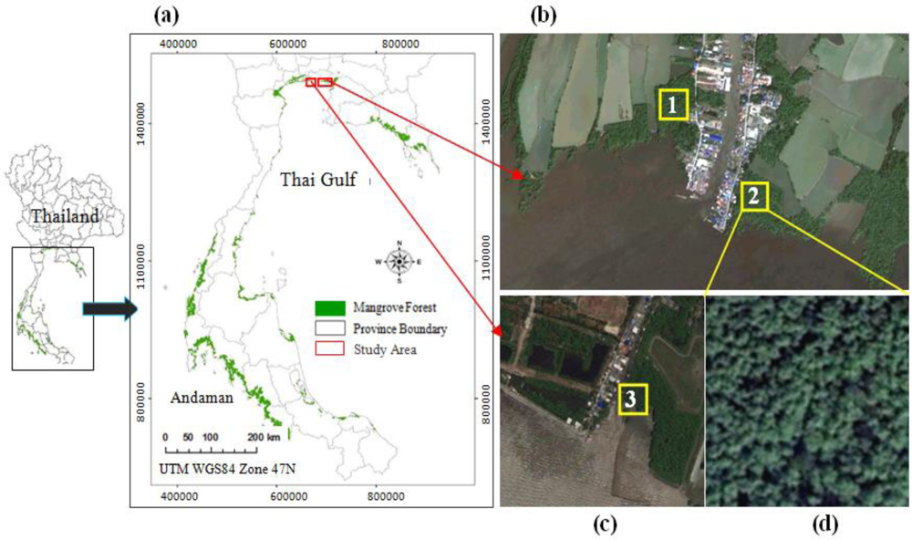
2.1. Study Site
2.2. LiDAR Dataset
2.3. Field Data Collection
2.4. Data Analysis
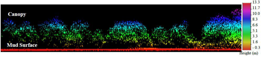
2.4.1. Canopy Height Model
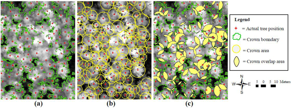
2.4.2. Crown Overlap
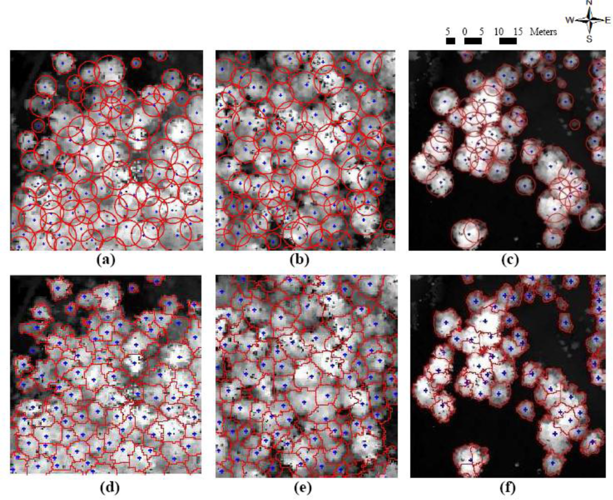
2.4.3. Variable Window Filtering
2.4.4. Inverse Watershed Segmentation
2.4.5. Tree Matching Evaluation
3. Results and Discussion
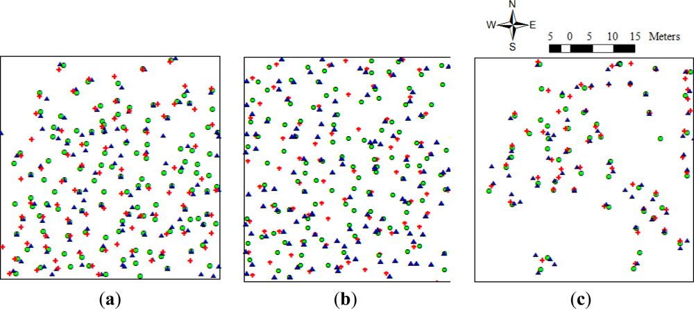
3.1. Individual Tree Detection
3.2. Tree Position Accuracy
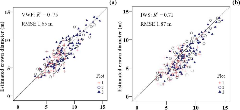
3.3. Measurement of Crown Diameter
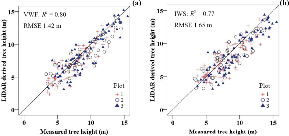
3.4. Tree Height Extraction
4. Conclusions
- (i)
- The VWF method yielded a slightly higher accuracy for mangrove parameter extractions from LiDAR-derived CHM compared with the IWS method. The accuracy of the VWF method depends on the allometric relationships between tree height and crown diameter. In contrast, the IWS method does not require an empirical and site-specific allometric model. The benefits of IWS are that it is convenient and it saves time. However, the automatic segmentation of the tree crown usually results in small fragments, particularly in dense mangrove canopies. This problem affects the high commission error of the individual tree detection and underestimation of the crown diameter.
- (ii)
- The VWF and IWS methods can detect individual mangroves from the LiDAR-derived CHM with an accuracy of 87% and 82% and mean position error values of 1.10 m and 1.42 m, respectively. Both methods have high commission errors, which results in an overestimate of trees. This overestimation is mainly due to the effect of the multiple treetops, which relate to the canopy characteristics and segmented algorithms. However, the VWF method shows the kappa coefficient of agreement (K) value of 0.78. The VWF method could minimize this effect by requiring the allometric model to specify the appropriate circular window filtering size for searching the treetop location.
- (iii)
- An increase in the percentage of crown overlap (COL) results in an accuracy decrease of the mangrove parameters extracted from the LiDAR-derived CHM. In addition, COL strongly affected the accuracy of crown diameter extractions, especially when the IWS method was utilized. The results of the IWS method tended to underestimate the crown diameter, with a Mean Difference (MD) value of −0.95 m.
- (iv)
- For the tree height estimation from the LiDAR-derived CHM, the VWF method yielded the highest coefficient of determination (R2) value of 0.80 and Root Mean Square Error (RMSE) value of 1.42 m. The VWF method was superior to the IWS method, with an RMSE difference value of 23 cm. The results tended to underestimate the tree height, with MD values of −0.42 to −0.58 m.
- (v)
- In this study, the accuracy of the LiDAR-derived biophysical parameters in mangrove forests using the VWF and IWS methods is lower than in coniferous, boreal, pine, and deciduous forests. The lower estimation accuracy is mainly due to differences in forest density, canopy structure and density of the LiDAR point clouds.
Acknowledgments
References
- Kuenzer, C.; Bluemel, A.; Gebhardt, S.; Quoc, T.V.; Dech, S. Remote sensing of mangrove ecosystems: A Review. Remote Sens 2011, 3, 878–928. [Google Scholar]
- Food and Agricultural Organization (FAO). Management and Utilization of Mangroves in Asia and Pacific; FAO Environment Paper No.3; Agriculture Department: Rome, Italy, 1982; p. 166. [Google Scholar]
- Harada, K.; Imamura, F. Experimental Study on the Effect in Reducing Tsunami by the Coastal Permeable Structures. Proceedings of the Twelfth International Offshore and Polar Engineering Conference, Kitakyushu, Japan, 26–31 May 2002; pp. 652–658.
- Danielsen, F.; Sørensen, M.K.; Olwig, M.F.; Selvam, V.; Parish, F.; Burgess, N.D.; Hiraishi, T.; Karunagaran, V.M.; Rasmussen, M.S.; Hansen, L.B.; et al. The Asian Tsunami: A protective role for coastal vegetation. Science 2005. [Google Scholar] [CrossRef]
- Lieth, H.; Whittaker, R.H. (Eds.) Primary Production of the Major Vegetation Units of the World. In Primary Productivity of the Biosphere; Springer: Berlin/Heidelberg, Germany, 1975; pp. 305–328.
- McNally, R.; McEwin, A.; Holland, T. The Potential for Mangrove Carbon Projects in Vietnam; SNV-Netherlands Development Organisation REDD+ Programme: Ha Noi, Vietnam, 2011. [Google Scholar]
- Kristensen, E.; Bouillon, S.; Dittmar, T.; Marchand, C. Organic carbon dynamics in mangrove ecosystems: A review. Aquat. Bot 2008, 89, 201–219. [Google Scholar]
- Komiyama, A.; Poungparn, S.; Kato, S. Common allometric equations for estimating the tree weight of mangroves. J. Trop. Ecol 2005, 21, 471–477. [Google Scholar]
- Komiyama, A.; Ong, J.E.; Poungparn, S. Allometry, biomass, and productivity of mangrove forests: A review. Aquat. Bot 2007, 89, 128–137. [Google Scholar]
- Zhang, K.; Simard, M.; Ross, M.; Rivera-Monroy, V.H.; Houle, P.; Ruiz, P.; Twilley, R.R.; Whelan, K. Airborne laser scanning quantification of disturbances from hurricanes and lightning strikes to mangrove forests in Everglades National Park, USA. Sensors 2008, 8, 2262–2292. [Google Scholar]
- Cole, T.G.; Ekel, K.C.; Devoe, N.N. Structure of mangrove tree and forest in Micronesia. Forest Ecol. Manage 1999, 117, 95–109. [Google Scholar]
- Malthus, T.J.; Mumby, P.J. Remote sensing of the coastal zone: An overview and priorities for future research. Int. J. Remote Sens 2003, 24, 2805–2815. [Google Scholar]
- Lucas, R.M.; Ellison, J.C.; Mitchell, A.; Donnelly, B.; Finlayson, M.; Milne, A.K. Use of stereo aerial photography for quantifying changes in the extent and height of mangroves in tropical Australia. Wetlands Ecol. Manage 2002, 10, 161–175. [Google Scholar]
- Giri, C.; Pengra, B.; Zhu, Z.; Singh, A.; Tieszen, L.L. Monitoring Mangrove forest dynamics of the Sundarbans in Bangladesh and India using multi-temporal satellite data from 1973 to 2000. Estuar. Coast. Shelf Sci 2007, 73, 91–100. [Google Scholar]
- Wang, L.; Sousa, W.P.; Gong, P.; Biging, G.S. Comparison of IKONOS and QuickBird imagery for mapping mangrove species on the Caribbean coast of Panama. Remote Sens. Environ 2004, 91, 432–440. [Google Scholar]
- Yang, C.; Everitt, J.H.; Fletcher, R.S.; Jensen, R.R.; Mausel, P.W. Evaluating AISA+ hyperspectral imagery for mapping black mangrove along the South Texas Gulf Coast. Photogramm. Eng. Remote Sensing 2009, 75, 425–435. [Google Scholar]
- Wang, L.; Sousa, W.P. Distinguishing mangrove species with laboratory measurements of hyperspectral leaf reflectance. Int. J. Remote Sens 2009, 30, 1267–1281. [Google Scholar]
- Meza Diaz, B.; Blackburn, G.A. Remote sensing of mangrove biophysical properties: Evidence from a laboratory simulation of the possible effects of background variation on spectral vegetation indices. Int. J. Remote Sens 2003, 24, 53–73. [Google Scholar]
- Alongi, D.M. Mangrove forests: Resilience; protection from tsunamis; and responses to global climate change. Estuar. Coast. Shelf Sci 2008, 76, 1–13. [Google Scholar]
- Cochard, R.; Ranamukhaarachchi, S.L.; Shivakoti, G.P.; Shipin, O.V.; Edwards, P.J.; Seeland, K.T. The 2004 tsunami in Aceh and Southern Thailand: A review on coastal ecosystems; wave hazards and vulnerability. Perspect. Plant Ecol. Evol. Syst 2008, 10, 3–40. [Google Scholar]
- Lucas, R.M.; Mitchell, A.L.; Rosenqvist, A.; Proisy, C.; Melius, A.; Ticehurst, C. The potential of L-band SAR for quantifying mangrove characteristics and change: Case studies from the tropics. Aquat. Conserv 2007, 17, 245–264. [Google Scholar]
- Kovacs, J.M.; Vandenberg, C.V.; Wang, J.; Flores-Verdugo, F. The use of multipolarized spaceborne SAR backscatter for monitoring the health of a degraded mangrove forest. J. Coast. Res 2008, 24, 248–254. [Google Scholar]
- Souza Filho, P.W.; Paradella, W.R. Use of RADARSAT-1 fine mode and Landsat-5 TM selective principal component analysis for geomorphological mapping in a macrotidal mangrove coast in the Amazon Region. Can. J. Remote Sens 2005, 31, 214–224. [Google Scholar]
- Ozdemir, I. Estimating stem volume by tree crown area and tree shadow area extracted from pan-sharpened Quickbird imagery in open Crimean juniper forests. Int. J. Remote Sens 2008, 29, 5643–5655. [Google Scholar]
- Myint, S.W.; Giri, C.P.; Wang, L.; Zhu, Z.; Gillette, S. Identifying mangrove species and their surrounding land use and land cover classes using an object oriented approach with a lacunarity spatial measure. GIScience Remote Sens 2008, 45, 188–208. [Google Scholar]
- Lovell, J.L.; Jupp, D.L.B.; Newnham, G.J.; Coops, N.C.; Culvenor, D.S. Simulation study for finding optimal lidar acquisition parameters for forest height retrieval. Forest Ecol. Manage 2005, 214, 398–412. [Google Scholar]
- Zhang, K. Identification of gaps in mangrove forests with airborne LiDAR. Remote Sens. Environ 2007, 112, 2309–2325. [Google Scholar]
- Brandtberg, T.; Warner, T.A.; Landenberger, R.E.; McGraw, J.B. Detection and analysis of individual leaf-off tree crowns in small footprint, high sampling density lidar data from the eastern deciduous forest in North America. Remote Sens. Environ 2003, 85, 290–303. [Google Scholar]
- Edson, C.; Wing, M.G. Airborne Light Detection and Ranging (LiDAR) for individual tree stem location, height, and biomass measurements. Remote Sens 2011, 3, 2494–2528. [Google Scholar]
- Lindberg, E.; Hollaus, M. Comparison of methods for Estimation of stem volume, stem number and basal area from Airborne laser scanning data in a hemi-boreal forest. Remote Sens 2012, 4, 1004–1023. [Google Scholar]
- Pirotti, F. Assessing a template matching approach for tree height and position extraction from lidar-derived canopy height models of pinus pinaster stands. Forests 2010, 1, 194–208. [Google Scholar]
- Popescu, S.C. Estimating biomass of individual pine and trees using airborne lidar. Biomass Bioenergy 2007, 31, 646–655. [Google Scholar]
- Tesfamichael, S.G.; van Aardt, J.A.N.; Ahmed, F. Estimating plot-level tree height and volume of Eucalyptus grandis plantations using small-footprint, discrete return lidar data. Progr. Phys. Geogr 2010, 34, 515–540. [Google Scholar]
- Shrestha, R.; Wynne, R.H. Estimating biophysical parameters of individual trees in an urban environment using small footprint discrete-return imaging lidar. Remote Sens 2012, 4, 484–508. [Google Scholar]
- Long, G.C.; Larry, J.T. Mapping and monitoring Louisiana’s Mangroves in the aftermath of the 2010 gulf of Mexico oil spill. J. Coastal Res 2011, 27, 1059–1064. [Google Scholar]
- Benjamin, W.H. Satellite remote sensing of mangrove forests: Recent advances and future opportunities. Progr. Phys. Geogr 2011, 35, 87–108. [Google Scholar]
- John, C. Integrated LiDAR and IKONOS multispectral imagery for mapping mangrove distribution and physical properties. Int. J. Remote Sens 2011, 32, 6765–6781. [Google Scholar]
- Zhang, K.; Patricia, A.H.; Michael, S.R.; Pablo, L.R.; Marc, S. Airborne Laser Mapping of Mangroves on the Biscayne Bay Coast, Miami, Florida. Proceedings of IEEE International Conference on Geoscience and Remote Sensing Symposium, 2006 (IGARSS 2006), Miami, FL, USA, 31 July–4 August 2006; pp. 3750–3754.
- Temilola, F.E.; Marc, S. Height and biomass of mangroves in Africa from ICESat/GLAS and SRTM. Int. J. Remote Sens 2013, 34, 668–681. [Google Scholar]
- Simard, M.; Rivera-Monroy, V.H.; Mancera-Pineda, J.E.; Castañeda-Moya, E.; Twilley, R.R. A systematic method for 3D mapping of mangrove forests based on Shuttle Radar Topography Mission elevation data, ICEsat/GLAS waveforms and field data. Remote Sens. Environ 2008, 112, 2131–2144. [Google Scholar]
- Falkowski, M.J.; Smith, A.M.S.; Gessler, P.E.; Hudak, A.T.; Vierling, L.A.; Evans, J.S. The influence of conifer forest canopy cover on the accuracy of two individual tree measurement algorithms using lidar data. Can. J. Remote Sens 2008, 34, S338–S350. [Google Scholar]
- Popescu, S.C.; Wynne, R.H. Seeing the trees in the forest: Using lidar and multispectral data fusion with local filtering and variable window size for estimating tree height. Photogramm. Eng. Remote Sensing 2004, 70, 589–604. [Google Scholar]
- Falkowski, M.J.; Smith, A.M.S.; Hudak, A.T.; Gessler, P.E.; Vierling, L.A.; Crookston, N.L. Automated estimation of individual conifer tree height and crown diameter via two dimensional spatial wavelet analysis of lidar data. Can. J. Remote Sens 2006, 32, 153–161. [Google Scholar]
- Jing, L.; Hu, B.; Noland, T.; Li, J. An individual tree crown delineation method based on multi-scale segmentation of imagery. ISPRS J. Photogramm 2012, 70, 88–98. [Google Scholar]
- Chen, Q.; Baldicchi, D.; Gong, P.; Kelly, M. Isolation individual tree in a savanna woodland using small footprint LiDAR Data. Photogramm. Eng. Remote Sensing 2006, 72, 923–932. [Google Scholar]
- Mangrove Resource Convention Office, Department of Marine and Coastal Resources. Mangrove in Thailand; The Communities of Agriculture and Cooperatives: Bangkok, Thailand, 2009; p. 167. [Google Scholar]
- Kitamura, S.; Anwar, C.; Chaniago, A.; Baba, S. Handbook of Mangroves in Indonesia; The International Society for Mangrove Ecosystem: Saritaksu Denpasar, Bali, Indonesia, 1997; p. 199. [Google Scholar]
- Optech Incorporated. ALTM 2050 Airborne Laser Terrain Mapper: The Ultimate in Performance; Optech Incorporated: Toronto, ON, Canada, 2002. [Google Scholar]
- Soininen, A. TerraScan User’s Guide; The National Mapping Agency of Great Britain: Southampton, UK, 2012. [Google Scholar]
- Hugelschaffer, D. Use of LiDAR in Forestry Applications; Sunpine Forest Products Ltd: Sundre, AB, Canada, 2004. [Google Scholar]
- Kaewwong, A.; Boonyawat, S.; Aksornkoae, S.; Tabthipwon, P. The Suitable Mangrove Tree Species for Planting on the Abandoned Mining Area, Changwat Ranong. Proceedings of 39th Kasetsart University Annual Conference: Science, Natural Resources and Environmental Economics, Bangkok, Thailand, 4–5 February 2001; 1, pp. 409–417.
- Popescu, S.C.; Wynne, R.H.; Nelson, R.F. Measuring individual tree crown diameter with lidar and assessing its influence on estimating forest volume and biomass. Can. J. Remote Sens 2003, 29, 564–577. [Google Scholar]
- Beucher, S.; Lantuéjoul, C. Use of Watersheds in Contour Detection. Proceedings of International Workshop on Image Processing, Real-Time Edge and Motion Detection, Rennes, France, 17–21 September 1979.
- Andersen, H.E. Using airborne light detection and ranging (lidar) to characterize forest stand condition on the Kenai Peninsula of Alaska. West. J. Appl. Forest 2009, 24, 95–102. [Google Scholar]
- Ziegler, M.; Konrad, M.; Hofrichter, J.; Wimmer, A.; Ruppert, G.; Schardt, M.; Hyyppa, J. Assessment of forest attributes and single-tree segmentation by means of forest scanning. Proc. SPIE 2000, 4035, 73–84. [Google Scholar]
- Hyppä, J.; Kelle, O.; Lehikoinen, M.; Inkinen, M. A segmentation-based method to retrieve stem volume estimates from 3-D tree height models produced by laser scanners. IEEE Trans. Geosci. Remote Sens 2001, 39, 969–975. [Google Scholar]
- Schardt, M.; Ziegler, M.; Wimmer, A.; Wack, R.; Hyyppä, J. Assessment of forest parameters by means of laser scanning. Int. Arch. Photogramm. Remote Sens 2002, 34, 302–309. [Google Scholar]
- Kaartinen, H.; Hyyppä, J.; Yu, X.; Vastaranta, M.; Hyyppä, H.; Kukko, A.; Holopainen, M.; Heipke, C.; Hirschmugl, M.; Morsdorf, F.; et al. An international comparison of individual tree detection and extraction using airborne laser scanning. Remote Sens 2012, 4, 950–974. [Google Scholar]
- Persson, Å.; Holmgren, J.; Södermann, U. Detecting and measuring individual trees using an airborne laser scanner. Photogramm. Eng. Remote Sensing 2002, 68, 925–932. [Google Scholar]
- Arzai, A.H.; Aliyu, B.S. The relationship between canopy width, height and trunk size in some tree species growth in the Savana zone of Nigeria. Bayero J. Pure Appl. Sci 2010, 3, 260–263. [Google Scholar]
- Mugo, J.M.; Njunge, J.T.; Malimbwi, R.E.; Kigomo, B.N.; Mwasi, B.N.; Muchiri, M.N. Models for predicting stem diameter from crown diameter of open grown trees in Sondu-Nyando river catchment, Kenya. Asian J. Agric. Sci 2011, 3, 119–126. [Google Scholar]
- Eysn, L.; Hollaus, M.; Schadauer, K.; Pfeifer, N. Forest delineation based on airborne lidar data. Remote Sens 2012, 4, 762–783. [Google Scholar]
- Hyyppä, J.; Inkinen, M. Detecting and estimating attributes for single trees using laser scanner. Photogramm. J. Finl 1999, 16, 27–42. [Google Scholar]
- Hopkinson, C.; Chasmer, L.; Sass, G.; Creed, I.; Sitar, M.; Kalbfleisch, W.; Treitz, P. Vegetation class dependent errors in lidar ground elevation and canopy height estimates in a boreal wetland environment. Can. J. Remote Sens 2005, 31, 191–206. [Google Scholar]
- Maltamo, M.; Mustonen, K.; Hyyppä, J.; Yu, X. The accuracy of estimating individual tree variables with airborne laser scanning in a boreal nature reserve. Can. J. Forest Res 2004, 34, 1791–1801. [Google Scholar]
- Gaveau, D.L.A.; Hill, R. Quantifying canopy height underestimation by laser pulse penetration in small-footprint airborne laser scanning data. Can. J. Remote Sens 2003, 29, 650–657. [Google Scholar]
- Chasmer, L.; Hopkinson, C.; Treitz, P. Investigating laser pulse penetration through a conifer canopy by integrating airborne and terrestrial lidar. Can. J. Remote Sens 2006, 32, 116–125. [Google Scholar]
- Hyyppä, J.; Pyysalo, U.; Hyyppä, H.; Samberg, A. Elevation of Accuracy of Laser Scanning-Derived Digital Terrain and Target Models in Forest Environment. Proceedings of EARSeL-SIG-Workshop LIDAR, Dresden, Germany, 16–17 June 2000.


| Parameter | Specification |
|---|---|
| System | Airborne Laser Terrain Mapper (ALTM) 2050 |
| Horizontal Accuracy | 1/2,000 × altitude (≈60 cm) |
| Vertical Accuracy | 15 cm at 1,200 m |
| Scanning frequency rate | 28 Hz |
| Laser repetition rate | 50 kHz |
| Flight altitude | 1,200 m |
| Swath width | 750 m |
| Scanning angle | 0° to ±20° |
| Footprint | 5 cm |
| Pulse return | First and last |
| Laser point density | 2.7 points/m2 |
| Descriptive Statistics | Plot 1 | Plot 2 | Plot 3 | |
|---|---|---|---|---|
| Plot area (ha) | 0.32 | 0.67 | 0.68 | |
| Number of trees | 82 | 80 | 52 | |
| Tree density (tree/100 m2) | 2.50 | 1.20 | 0.75 | |
| Crown diameter (m) | min–max | 3.0–12.0 | 3.2–14.5 | 3.5–15.0 |
| mean | 7.5 | 8.3 | 9.3 | |
| SD | 1.2 | 2.9 | 1.8 | |
| Tree height (m) | min–max | 3.1–11.0 | 3.3–14.0 | 3.5–15.5 |
| mean | 7.0 | 7.3 | 7.8 | |
| SD | 1.4 | 1.9 | 1.5 | |
| DBH (cm) | min–max | 8.0–31.0 | 11.0–36.0 | 8.5–35.1 |
| mean | 17.1 | 20.5 | 23.2 | |
| SD | 4.5 | 6.4 | 5.3 | |
| Site | Annual Increase (cm/year) | References | |||
|---|---|---|---|---|---|
| Tree Height | Crown Diameter | ||||
| A. alba | A. officinalis | A. alba | A. officinalis | ||
| Samut-Prakan, Thailand | 13.72 | 14.51 | 14.02 | 15.34 | This study |
| SD: 2.1 | SD: 2.4 | SD: 5.0 | SD: 4.7 | ||
| Ranong, Thailand | 13.96 | 16.04 | - | - | [51] |
| Area (m2) | Plot 1 | Plot 2 | Plot 3 |
|---|---|---|---|
| Plot area | 3,248 | 6,750 | 6,885 |
| Crown area | 2,972 | 5,355 | 3,051 |
| Non-Crown area | 276 | 1,395 | 3,834 |
| Crown area overlap | 1,545 | 2,275 | 843 |
| Crown overlap: COL (% ) | 52 | 42 | 28 |
| Measure of Inter-Rater Agreement | VWF | IWS | ||||||
|---|---|---|---|---|---|---|---|---|
| Plot (COL%) | Plot (COL%) | |||||||
| Plot 1 (52%) | Plot 2 (42%) | Plot 3 (28%) | Pooled Dataset | Plot 1 (52%) | Plot 2 (42%) | Plot 3 (28%) | Pooled Dataset | |
| Ns | 82 | 80 | 52 | 214 | 82 | 80 | 52 | 214 |
| Ni | 102 | 98 | 62 | 262 | 120 | 110 | 65 | 295 |
| Nc | 34 | 28 | 14 | 76 | 56 | 46 | 18 | 120 |
| No | 14 | 10 | 4 | 28 | 18 | 16 | 5 | 39 |
| Nm | 68 | 70 | 48 | 186 | 64 | 64 | 47 | 175 |
| Pra | 0.83 | 0.88 | 0.92 | 0.87 | 0.78 | 0.80 | 0.90 | 0.82 |
| Pre | 0.10 | 0.08 | 0.05 | 0.08 | 0.18 | 0.15 | 0.07 | 0.14 |
| Cerr | 0.29 | 0.26 | 0.21 | 0.26 | 0.41 | 0.37 | 0.26 | 0.36 |
| Oerr | 0.12 | 0.09 | 0.06 | 0.10 | 0.13 | 0.13 | 0.07 | 0.12 |
| K | 0.72 | 0.79 | 0.87 | 0.78 | 0.56 | 0.62 | 0.83 | 0.65 |
| Dataset | RMSE (m) | ||||
|---|---|---|---|---|---|
| Plot 1 | Plot 2 | Plot 3 | Pooled Dataset | ||
| COL (%), D (tree/100 m2) | 52, 2.5 | 42, 1.2 | 28, 0.75 | - | |
| Method | VWF | 1.52 | 0.97 | 0.74 | 1.10 |
| IWS | 1.71 | 1.32 | 1.05 | 1.42 | |
| Dataset | Plot 1 | Plot 2 | Plot 3 | Pooled Dataset | |
|---|---|---|---|---|---|
| COL (%), D (tree/100 m2) | 52, 2.5 | 42, 1.2 | 28, 0.75 | ||
| R2 | VWF | 0.58 | 0.72 | 0.77 | 0.75 |
| IWS | 0.43 | 0.63 | 0.74 | 0.71 | |
| RMSE (m) | VWF | 2.14 | 1.71 | 1.53 | 1.65 |
| IWS | 2.34 | 2.15 | 1.60 | 1.87 | |
| RE (%) | VWF | 28.5 | 20.6 | 16.4 | 19.7 |
| IWS | 31.2 | 25.9 | 17.2 | 22.4 | |
| MD | VWF | −0.39 | −0.32 | −0.21 | −0.29 |
| IWS | −1.03 | −0.97 | −0.93 | −0.95 | |
| Forest Type | Point Cloud Density (point/m2) | Pixel Size | Method | R2 and (RMSE) | Reference | ||
|---|---|---|---|---|---|---|---|
| CD (m) | H (m) | Location (x, y) m | |||||
| Pine | 1.35 | 0.5 | VWF | 0.62 (1.36) | 0.97 (1.14) | - | [41,42] |
| Deciduous | 1.35 | 0.5 | VWF | 0.63 (1.41) | 0.79 (1.91) | - | [41,42] |
| Mixed Coniferous | 1.95 m. (point spacing) | 0.5 | VWF | 0.79 (1.66) | 0.97 (2.81) | - | [43] |
| Coniferous | 8 | 0.5 | VWF | - | (0.28) | (2.19) | [31] |
| Coniferous | 8 | 0.5 | IWS | - | (0.22) | (2.31) | [31] |
| Boreal | - | 1.0 | IWS | (1.46) | (1.23) | - | [54] |
| Mangrove | 2.7 | 0.5 | VWF | 0.75 (1.65) | 0.80 (1.42) | (1.10, 1.25) | This study |
| Mangrove | 2.7 | 0.5 | IWS | 0.71 (1.87) | 0.77 (1.65) | (1.53, 1.74) | This study |
| Dataset | Plot 1 | Plot 2 | Plot 3 | Pooled Dataset | |
|---|---|---|---|---|---|
| COL(%), D (tree/100 m2) | 52, 2.5 | 42, 1.2 | 28, 0.75 | ||
| R2 | VWF | 0.76 | 0.77 | 0.82 | 0.80 |
| IWS | 0.72 | 0.73 | 0.78 | 0.77 | |
| RMSE (m) | VWF | 1.68 | 1.55 | 1.45 | 1.42 |
| IWS | 1.74 | 1.58 | 1.53 | 1.65 | |
| RE (%) | VWF | 24.0 | 21.2 | 18.6 | 19.2 |
| IWS | 24.9 | 21.6 | 19.6 | 22.3 | |
| MD | VWF | −0.25 | −0.52 | −0.55 | −0.42 |
| IWS | −0.41 | −0.53 | −0.78 | −0.58 | |
Share and Cite
Wannasiri, W.; Nagai, M.; Honda, K.; Santitamnont, P.; Miphokasap, P. Extraction of Mangrove Biophysical Parameters Using Airborne LiDAR. Remote Sens. 2013, 5, 1787-1808. https://doi.org/10.3390/rs5041787
Wannasiri W, Nagai M, Honda K, Santitamnont P, Miphokasap P. Extraction of Mangrove Biophysical Parameters Using Airborne LiDAR. Remote Sensing. 2013; 5(4):1787-1808. https://doi.org/10.3390/rs5041787
Chicago/Turabian StyleWannasiri, Wasinee, Masahiko Nagai, Kiyoshi Honda, Phisan Santitamnont, and Poonsak Miphokasap. 2013. "Extraction of Mangrove Biophysical Parameters Using Airborne LiDAR" Remote Sensing 5, no. 4: 1787-1808. https://doi.org/10.3390/rs5041787
APA StyleWannasiri, W., Nagai, M., Honda, K., Santitamnont, P., & Miphokasap, P. (2013). Extraction of Mangrove Biophysical Parameters Using Airborne LiDAR. Remote Sensing, 5(4), 1787-1808. https://doi.org/10.3390/rs5041787