Flux Measurements in Cairo. Part 2: On the Determination of the Spatial Radiation and Energy Balance Using ASTER Satellite Data


Abstract
:1. Introduction
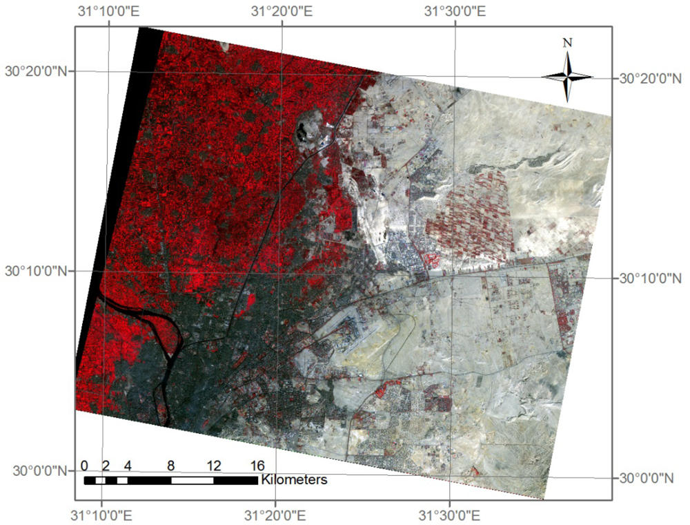
2. Study Area
3. Data
3.1. Satellite Data
3.2. In situ Data
4. Methods: Radiation Balance
4.1. Modeling of Net Radiation
4.1.1. Broadband Albedo α
4.1.2. Outgoing Long Wave Emission L↑
4.1.3. Incoming Broadband Irradiation K↓ and Incoming Long Wave Radiation L↓
5. Methods: Heat Fluxes
5.1. Modeling of the Ground Heat Flux Qs
5.2. LUMPS
5.3. ARM (Aerodynamic Resistance Method)
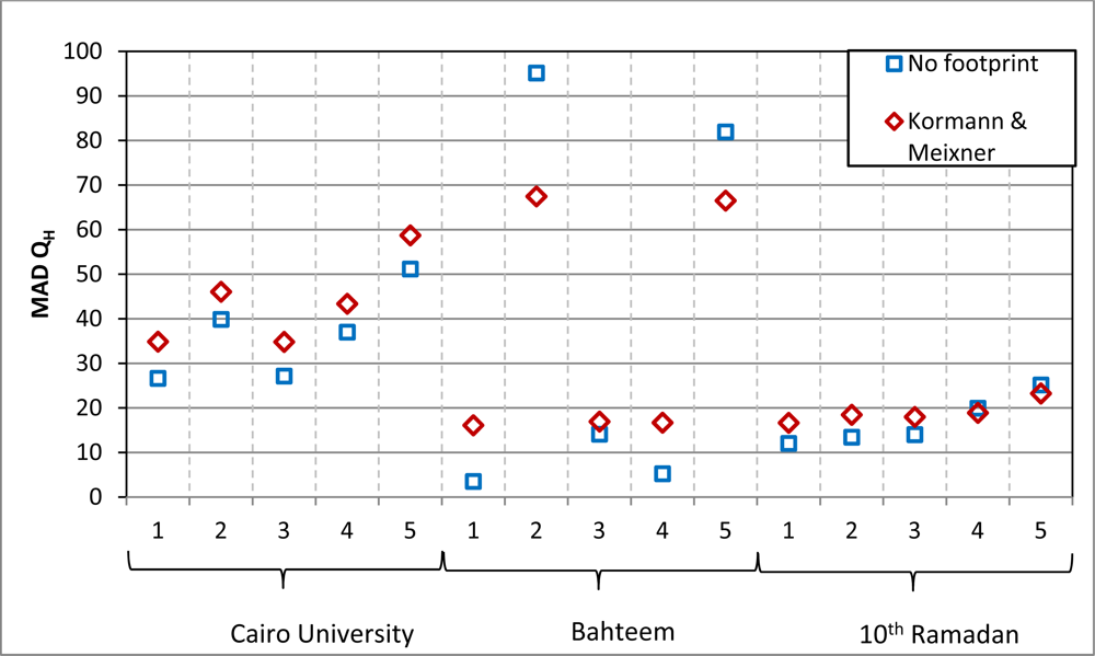
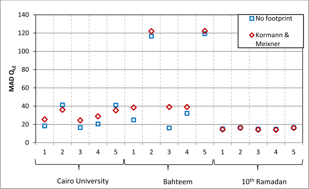
5.4. Source Footprint Models
6. Results
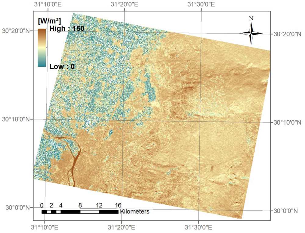
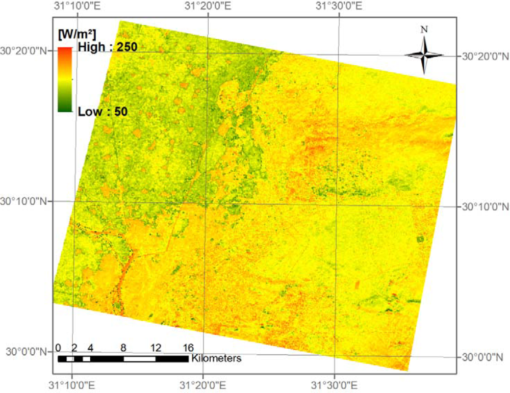
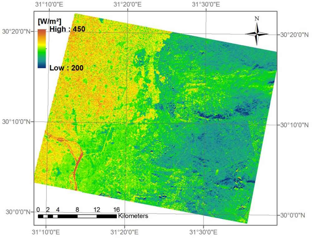
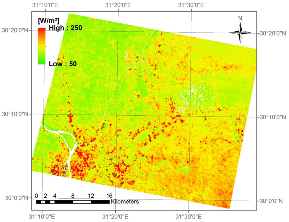
6.1. Radiation Fluxes
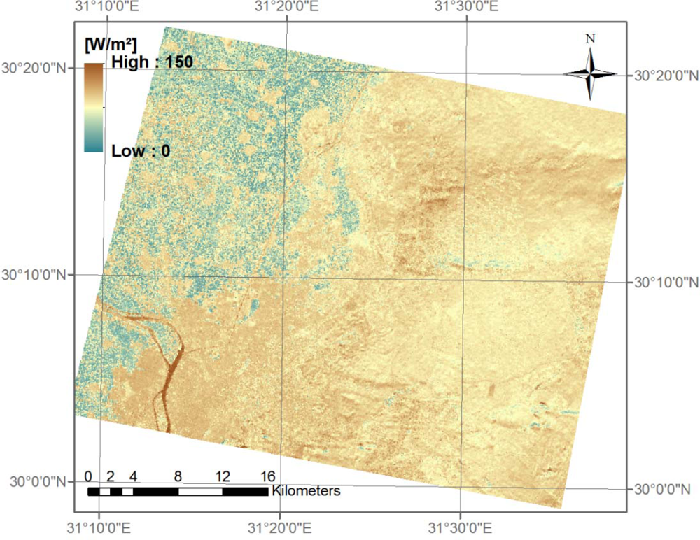
6.2. Ground Heat Flux
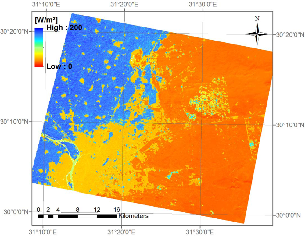
6.3. LUMPS
6.4. ARM
7. Discussion
- There is the error propagation from input variables, which was mentioned by [49]. Inaccuracies from input variables can result from various sources like BRDF effects, thermal anisotropy or an imprecise atmospheric correction. For example, in a single case at the desert station, the solar irradiation was underestimated about 99.6 W·m−2 (scene (a) of 22 November 2007, ‘best guess’) due to an inappropriate value of a MISR AOD product pixel. Q* then was underestimated 111.2 W·m−2. In the LUMPS approach this produced a difference to the ‘best fit’ option in QH of 31.1 W·m−2 taking the campaign retrieved parameters and the Qs of ‘Parlow/urban’. The difference in QLE with the same input is only 4.7 W·m−2. Using the ARM approach, the difference between this ‘best guess’ option and the ‘best fit’ option is 35.7 W·m−2 for QLE. Dealing with such magnitudes, it is difficult to decide whether a spatial pattern is mainly governed by land use or due to incorrect atmospheric correction.The ground heat flux is an important input variable and also determines the accuracy of the subsequently calculated heat fluxes. Differences found between the remote sensing and the in situ ground heat flux are in the range of values found in [38]. It can be noted that differences are higher at the urban station compared to the agricultural and the desert station. This is probably due to the inability to measure directly the ground heat flux of an urban surface. So, the in situ data of the urban station are less accurate. The remote sensing ground heat flux was compared to 30-minute averages of in situ measurements. Direct comparison to one-minute averages would render extreme differences. This is because the storage heat flux as part of the ground heat flux showed extreme deviations due to short-time fluctuations of the surface temperature. Such high fluctuations can never be explained by instantaneous net radiation and vegetation indices only.
- The second concern in determining turbulent heat fluxes is the model uncertainty itself. Especially in heterogeneous environments, the development of a good model is important. For instance, the LUMPS method is using two empirical parameters which are dependent on the environment. It is a great challenge to find the right values for each pixel in such a fast changing landscape, especially as in situ measurements are scarce. This study has shown that adapting values from literature can lead to high mismatches.In the ARM method, both concerns can be found in the determination of the aerodynamic resistance for heat, which is dependent on surface roughness and on the conditions of convection and winds. An improper estimation of this variable will lead to a weak determination of heat fluxes. Additionally, the spatially distributed air temperature has to be estimated in the ARM method—A step which is crucial for flux determination accuracy.Bare soil and plant foliage temperatures contribute both to radiometric surface temperatures and contribute to the turbulent transport of sensible heat [6]. This problem, which applies only at the agricultural station, is not addressed by either the ARM or the LUMPS methods, and probably leads to higher differences at the agricultural station compared to the urban and the desert station.The discussion so far about flux determination accuracy neglects the problem of the imprecise determination of the turbulent fluxes by eddy covariance measurements. In inhomogeneous areas especially, the onsite flux determination is difficult, but also at our desert station, the measured energy balance had to be closed by force. Before closing, midday ensemble average of the residual term from the desert station was nearly 60 W·m−2; at the agricultural station, it almost reached 150 W·m−2. Similar residuals were found by [51] or [29]. Having these magnitudes of closure gaps in mind, the results of the remote sensing fluxes do actually compare quite well.
7. Conclusions
Acknowledgments
References
- Raga, G.B.; Castro, T.; Baumgardner, D. The impact of megacity pollution on local climate and implications for the regional environment: Mexico City. Atmos. Environ 2001, 35, 1805–1811. [Google Scholar]
- Tran, H.; Uchihama, D.; Ochi, S.; Yasuoka, Y. Assessment with satellite data of the urban heat island effects in Asia mega cities. Int. J. Appl. Earth Obs. Geoinf 2006, 8, 34–48. [Google Scholar]
- Choudhury, B.J.; Idso, S.B.; Reginato, R.J. Analysis of an empirical model for soil heat flux under a growing wheat crop for estimating evaporation by an infrared-temperature based energy balance equation. Agr. For. Meteorol 1987, 39, 283–297. [Google Scholar]
- Kustas, W.P.; Choudhury, B.J.; Moran, M.S.; Reginato, R.J.; Jackson, R.D.; Gay, L.W.; Weaver, H.L. Determination of sensible heat flux over sparse canopy using thermal infrared data. Agr. For. Meteorol 1989, 44, 197–216. [Google Scholar]
- Kustas, W.P.; Daughtry, C.S.T. Estimation of the soil heat flux/net radiation ratio from spectral data. Agr. For. Meteorol 1990, 49, 205–223. [Google Scholar]
- Zhan, X.; Kustas, W.P.; Humes, K.S. An intercomparison study on models of sensible heat flux over partial canopy surfaces with remotely sensed surface temperatures. Remote Sens. Environ 1996, 58, 242–256. [Google Scholar]
- Bastiaanssen, W.G.M.; Menenti, M.; Feddes, R.A.; Holtslag, A.A.M. A remote sensing surface energy balance algorithm for land (SEBAL). 1. Formulation. J. Hydrol 1998, 212–213, 198–212. [Google Scholar]
- Roerink, G.J.; Su, Z.; Menenti, M. S-SEBI: A simple remote sensing algorithm to estimate the surface energy balance. Phys. Chem. Earth Part B 2000, 25, 147–157. [Google Scholar]
- Voogt, J.A.; Grimmond, C.S.B. Modelling surface sensible heat flux using surface radiative temperatures in a simple urban area. J. Appl. Meteorol 2000, 39, 1679–1699. [Google Scholar]
- Su, Z. The surface energy balance system (SEBS) for estimation of turbulent heat fluxes. Hydrol. Earth Syst. Sci 2002, 6, 85–99. [Google Scholar]
- Ma, W.; Ma, Y.; Li, M.; Hu, Z.; Zhong, L.; Su, Z.; Ishikawa, H.; Wang, J. Estimating surface fluxes over the north Tibetan Plateau area with ASTER imagery. Hydrol. Earth Syst. Sci 2009, 13, 57–67. [Google Scholar]
- Mito, C.O.; Boiyo, R.K.; Laneve, G. A simple algorithm to estimate sensible heat flux from remotely sensed MODIS data. Int. J. Remote Sens 2012, 33, 6109–6121. [Google Scholar]
- Frey, C.M.; Parlow, E.; Vogt, R.; Abdel Wahab, M.; Harhash, M. Flux measurements in Cairo. Part 1: In situ measurements and their applicability for comparison with satellite data. Int. J. Climatol 2011, 31, 218–231. [Google Scholar]
- Verma, S.B. Aerodynamic Resistances to Transfers of Heat, Mass and Momentum. In Estimation of Areal Evapotranspiration; Black, T.A., Spittlehouse, D.L., Novak, M.D., Price, D.T., Eds.; IAHS Pub. No. 177; IAHS: Washington, DC, USA, 1989; pp. 13–20. [Google Scholar]
- Grimmond, C.S.B.; Oke, T.R. Aerodynamic properties of urban areas derived from analysis of surface form. J. Appl. Meteorol 1999, 38, 1262–1292. [Google Scholar]
- Frey, C.M.; Parlow, E. Determination of the aerodynamic resistance to heat using morphometric methods. EARSeL eProc 2010, 9, 52–63. [Google Scholar]
- Offerle, B.D. The Energy Balance of an Urban Area: Examining Temporal and Spatial Variability through Measurements, Remote Sensing and Modelling. Indiana University, Bloomington, IN, USA, 2003. [Google Scholar]
- Xu, W.; Wooster, M.J.; Grimmond, C.S.B. Modelling of urban sensible heat flux at multiple spatial scales: A demonstration using airborne hyperspectral imagery of Shanghai and a temperature-emissivity separation approach. Remote Sens. Environ 2008, 112, 3493–3510. [Google Scholar]
- Grimmond, C.S.B.; Oke, T.R. Turbulent heat fluxes in urban areas: Observations and a local-scale urban meteorological parameterization scheme (LUMPS). J. Appl. Meteorol 2002, 41, 792–810. [Google Scholar]
- de Bruin, H.A.R.; Holtslag, A.A.M. A simple parameterization of surface fluxes of sensible and latent heat during daytime compared with the Penman–Monteith concept. J. Appl. Meteorol 1982, 21, 1610–1621. [Google Scholar]
- Holtslag, A.A.M.; van Ulden, A.P. A simple scheme for daytime estimates of the surface fluxes from routine weather data. J. Appl. Meteorol 1983, 22, 517–529. [Google Scholar]
- Rigo, G. Satellite Analysis of Radiation and Heat Fluxes during the Basel Urban Boundary Layer Experiment (BUBBLE). University of Basel, Basel, Switzerland, 2007. [Google Scholar]
- Middel, A.; Brazel, A.J.; Kaplan, S.; Myint, S.W. Daytime cooling efficiency and diurnal energy balance in Phoenix, Arizona, USA. Climate Res 2012, 54, 21–34. [Google Scholar]
- Menenti, M.; Choudhury, B.J. Parameterization of Land Surface Evaporation Using a Location Dependent Potential Evaporation and Surface Temperature Range. In Exchange Processes at the Land Surface for a Range of Space and Time Scales; Bolle, H.J., Feddes, R.A., Kalma, J.D., Eds.; IAHS Publication: Washington, DC, USA, 1993; pp. 561–568. [Google Scholar]
- Zahira, S.A.H.; Mederbal, K.; Frederic, D. Mapping latent heat flux in the western forest covered regions of Algeria using remote sensing data and a spatialized model. Remote Sens 2009, 1, 795–817. [Google Scholar]
- Gowda, P.H.; Chávez, J.L.; Colaizzi, P.D.; Evett, S.R.; Howell, T.A.; Tolk, J.A. Remote sensing based energy balance algorithms for mapping ET: Current status and future challenges. Trans. ASABE 2007, 50, 1639–1644. [Google Scholar]
- Schlink, U.; Rehwagen, M.; Richter, M.; Herbarth, O. Environmental Security in Urban Areas. Health-Relevant VOC Exposure in the Greater Cairo Area, Egypt. In Managing Critical Infrastructure Risks: Decision Tools and Applications for Port Security; Linkov, I., Wenning, R.J., Kiker, G.A., Eds.; Springer: Dordrecht, The Netherlands, 2007; pp. 423–434. [Google Scholar]
- Martonchik, J.V.; Diner, D.J.; Kahn, R.A.; Ackerman, T.P.; Verstraete, M.M.; Pinty, B.; Gordon, H.R. Techniques for the retrieval of aerosol properties over land and ocean using multiangle imaging. IEEE Trans. Geosci. Remote Sens 1998, 36, 1212–1227. [Google Scholar]
- Wilson, K.; Goldstein, A.; Falge, E.; Aubinet, M.; Baldocchi, D.; Berbigier, P.; Bernhofer, C.; Ceulemanns, R.; Dolman, H.; Field, C.; et al. Energy balance closure at FLUXNET sites. Agr. For. Meteorol 2002, 113, 223–243. [Google Scholar]
- Foken, T. The energy balance closure problem: An overview. Ecol. Appl 2008, 18, 1351–1367. [Google Scholar]
- Twine, T.E.; Kustas, W.P.; Norman, J.M.; Cook, D.R.; Houser, P.R.; Meyers, T.P.; Prueger, J.H.; Starks, P.J.; Wesely, M.L. Correcting eddy-covariance flux underestimates over a grassland. Agr. For. Meteol 2000, 103, 279–300. [Google Scholar]
- Liang, S. Quantitative Remote Sensing of Land Surfaces; John Wiley & Sons, Inc: Hoboken, NJ, USA, 2005. [Google Scholar]
- Carlson, T.N.; Ripley, D.A. On the relation between NDVI, fractional vegetation cover and leaf area index. Remote Sens. Environ 1997, 62, 241–252. [Google Scholar]
- Frey, C.M.; Parlow, E. Geometry effect on the estimation of band reflectance in an urban area. Theor. Appl. Climatol 2009, 96, 395–406. [Google Scholar]
- Monteith, J.L.; Unsworth, M.H. Principles of Environmental Physics; Sevenoaks: London, UK, 1990. [Google Scholar]
- Norman, J.M.; Kustas, W.P.; Humes, K.S. Source approach for estimating soil and vegetation energy fluxes in observations of directional radiometric surface temperatures. Agr. For. Meteorol 1995, 77, 263–293. [Google Scholar]
- Sobrino, J.A.; Gómes, M.; Jiménez-Muñoz, J.C.; Olioso, A.; Chehbouni, G. A simple algorithm to estimate evapotranspiration from DAIS data: Application to the DAISEX campaigns. J. Hydrol 2005, 315, 117–125. [Google Scholar] [Green Version]
- Rigo, G.; Parlow, E. Modelling the ground heatflux of an urban area with remote sensing data. Theor. Appl. Climatol 2006, 90, 185–199. [Google Scholar]
- Prigent, C.; Tegen, I.; Aires, F.; Marticorena, B.; Zribi, M. Estimation of the aerodynamic roughness length in arid and semi-arid regions over the globe with the ERS scatterometer. J. Geophys. Res 2005, 110, 1–12. [Google Scholar]
- Greeley, R.; Blumberg, D.G.; McHone, J.F.; Dobrovolskis, A.; Iversen, J.D.; Lancaster, N.; Rasmussen, K.R.; Wall, S.D.; White, B.R. Applications of spaceborne radar laboratory data to the study of aeolian processes. J. Geophys. Res 1997, 102, 971–983. [Google Scholar]
- Blumberg, R.; Greeley, D.G. Field studies of aerodynamic roughness length. J. Arid Environ 1993, 25, 39–48. [Google Scholar]
- van Ulden, A.P. Simple estimates for vertical diffusion from sources near the ground. Atmos. Environ 1978, 12, 2125–2129. [Google Scholar]
- Pasquill, F.; Smith, F.B. Atmospheric Diffusion; Wiley: New York, NY, USA, 1983. [Google Scholar]
- Kormann, R.; Meixner, F.X. An analytic footprint model for neutral stratification. Bound.-Lay. Meteorol 2001, 99, 207–224. [Google Scholar]
- Hsieh, C.I.; Katul, G.; Chi, T. An approximate analytical model for footprint estimation of scalar fluxes in thermally stratified atmospheric flows. Adv. Water Resour 2000, 23, 765–772. [Google Scholar]
- Li, F.; Kustas, W.P.; Anderson, M.C.; Prueger, J.H.; Scott, R.L. Effect of remote sensing spatial resolution on interpreting tower-based flux observations. Remote Sens. Environ 2008, 112, 337–349. [Google Scholar]
- Chen, B.; Black, T.A.; Coops, N.C.; Hilker, T.; Trofymow, J.A.T.; Morgenstern, K. Assessing tower flux footprint climatology and scaling between remotely sensed and eddy covariance measurements. Bound.-Lay. Meteorol 2009, 130, 137–167. [Google Scholar]
- Ronglin, T.; Zhao-Liang, L.; Yuanyuan, J.; Chuanrong, L.; Xiaomin, S.; William, P.K.; Martha, C.A. An intercomparison of three remotesensing-based energy balance models using Large Aperture Scintillometer measurements over a wheat–corn production region. Remote Sens. Environ 2011, 115, 3187–3202. [Google Scholar]
- García, M.; Villagarcía, L.; Contreras, S.; Domingo, F.; Puigdefábregas, J. Comparison of three operative models for estimating the surface water deficit using ASTER reflective and thermal data. Sensors 2007, 7, 860–883. [Google Scholar]
- Kustas, W.P.; Norman, J.M. Evaluation of soil and vegetation heat flux predictions using a simple two-source model with radiometric temperatures for partial canopy cover. Agr. For. Meteorol 1999, 94, 13–29. [Google Scholar]
- Moderow, U.; Aubinet, M.; Feigenwinter, C.; Kolle, O.; Lindroth, A.; Mölder, M.; Montagnani, L.; Rebmann, C.; Bernhofer, C. Available energy and energy balance closure at four coniferous forest sites across Europe. Theor. Appl. Climatol 2009, 98, 397–412. [Google Scholar]
- Chang, T.-Y.; Liou, Y.-A.; Lin, C.-Y.; Liu, S.-C.; Wang, Y.-C. Evaluation of surface heat fluxes in Chiayi plain of Taiwan by remotely sensed data. Int. J. Remote Sens 2010, 31, 3885–3898. [Google Scholar]
Appendix
- Desert:
- Vegetation:
- Water:
- Urban:

| Hour | Γ | Hour | Γ |
|---|---|---|---|
| 07:00 | 0.000 | 12:00 | 1.396 |
| 07:30 | 0.175 | 12:30 | 1.222 |
| 08:00 | 0.349 | 13:00 | 1.047 |
| 08:30 | 0.524 | 13:30 | 0.873 |
| 09:00 | 0.698 | 14:00 | 0.698 |
| 09:30 | 0.873 | 14:30 | 0.524 |
| 10:00 | 1.047 | 15:00 | 0.349 |
| 10:30 | 1.222 | 15:30 | 0.175 |
| 11:00 | 1.396 | 16:00 | 0.000 |
| 11:30 | 1.571 (= 90*π/180) |


| Date | Number of Scenes | Urban: ‘Cairo University’ | Agricultural: ‘Bahteem’ | Desert: ‘10th Ramadan’ |
|---|---|---|---|---|
| 22nd November 2007 | 2(a + b) | X | X | X |
| 1st December 2007 | 2(a + b) | X | X | X |
| 24th December 2007 | 2(a + b) | X | X | X |
| 2nd January 2008 | X |
| Urban: ‘Cairo University’ | Agricultural: ‘Bahteem’ | Desert: ‘10th Ramadan’ | ||||
|---|---|---|---|---|---|---|
| α | β | α | β | α | β | |
| Non-vegetated sector | 1.46 | 3.43 | 1.52 | 43.99 | 0.78 | 0.78 |
| Vegetated sector | 1.64 | 7.2 | 3.17 | 33.16 | 0.71 | 9.70 |
| Values from literature (Grimmond & Oke 2002) | 0.19 | −0.3 | 1.2 | 20 | 0.2 | 20 |
| MAD ‘Best Guess’ | MAD ‘Best Fit’ | |
|---|---|---|
| Albedo [%] | 3.5 (14.8 %) | 2.3 (9.7 %) |
| Irradiation [W·m−2] | 43.0 (7.4 %) | 10.1 (1.7 %) |
| Long wave emission [W·m−2] | 8.4 (2.0 %) | Na |
| Incoming long wave radiation [W·m−2] | 20.4 (6.5 %) | Na |
| Net radiation [W·m−2] | 37.6 (11.6 %) | 22.3 (6.9 %) |
| MAD [W·m−2] | MAD [%] | MAD [W·m−2] Single Stations | |||
|---|---|---|---|---|---|
| Urban | Agriculture | Desert | |||
| ‘Parlow/urban’ | 15.47 | 18.90 | 27.42 | 8.44 | 10.02 |
| ‘Frey/NDVI’ | 17.53 | 21.42 | 24.07 | 13.69 | 14.54 |
Share and Cite
Frey, C.M.; Parlow, E. Flux Measurements in Cairo. Part 2: On the Determination of the Spatial Radiation and Energy Balance Using ASTER Satellite Data. Remote Sens. 2012, 4, 2635-2660. https://doi.org/10.3390/rs4092635
Frey CM, Parlow E. Flux Measurements in Cairo. Part 2: On the Determination of the Spatial Radiation and Energy Balance Using ASTER Satellite Data. Remote Sensing. 2012; 4(9):2635-2660. https://doi.org/10.3390/rs4092635
Chicago/Turabian StyleFrey, Corinne Myrtha, and Eberhard Parlow. 2012. "Flux Measurements in Cairo. Part 2: On the Determination of the Spatial Radiation and Energy Balance Using ASTER Satellite Data" Remote Sensing 4, no. 9: 2635-2660. https://doi.org/10.3390/rs4092635
APA StyleFrey, C. M., & Parlow, E. (2012). Flux Measurements in Cairo. Part 2: On the Determination of the Spatial Radiation and Energy Balance Using ASTER Satellite Data. Remote Sensing, 4(9), 2635-2660. https://doi.org/10.3390/rs4092635