Identifying Spatial Units of Human Occupation in the Brazilian Amazon Using Landsat and CBERS Multi-Resolution Imagery

Abstract
:1. Introduction
2. Methodology
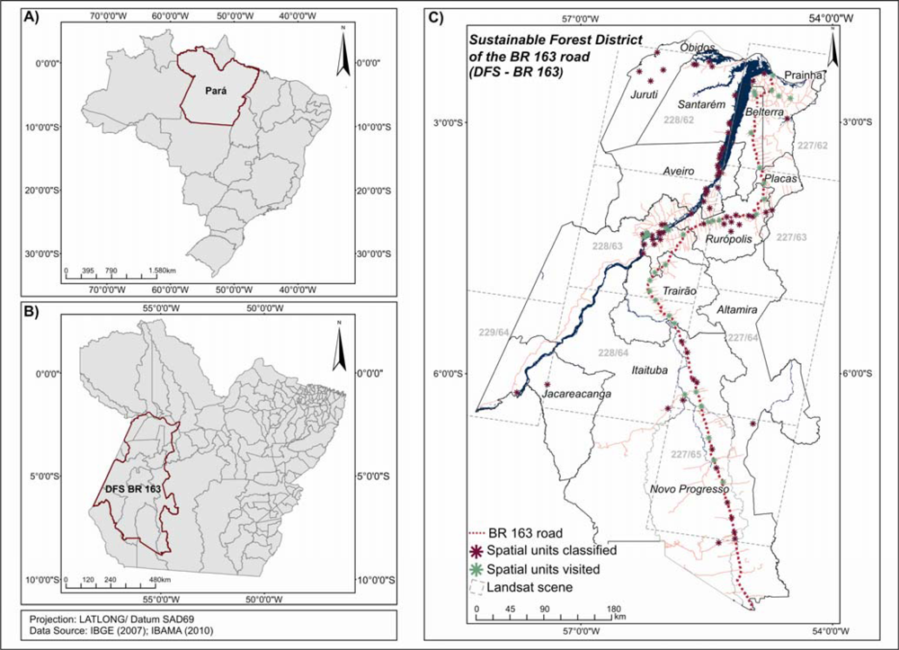
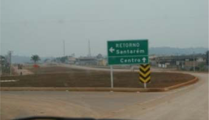
2.1. Study Site
2.2. Methodological Procedures
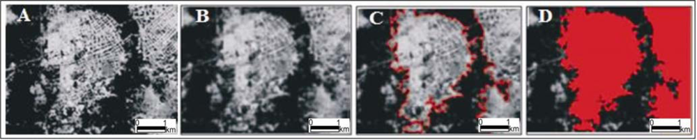
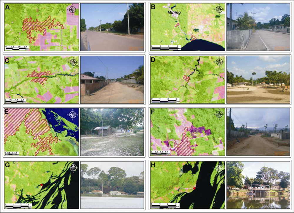
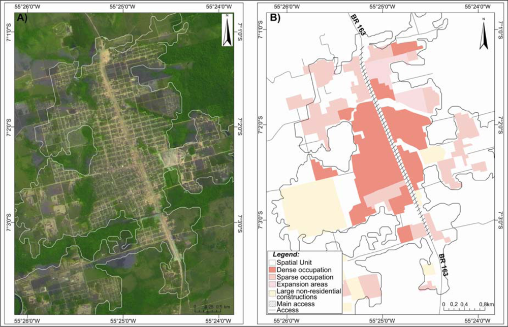
2.2.1. Identifying the Spatial Units of Human Occupation
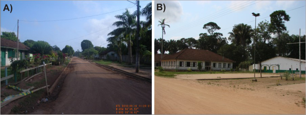
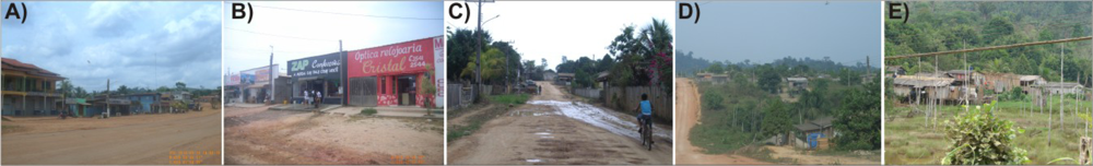
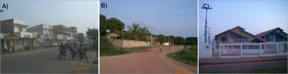
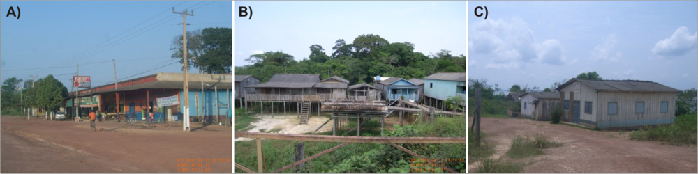
2.2.2. Characterizing the Spatial Units of Human Occupation
3. Results
4. Conclusions
Acknowledgments
References
- INPE. PRODES: Programa de Monitoramento do Desmatamento da Amazônia por Satélite. 2010. Available online: http://www.obt.inpe.br/prodes/ (accessed on 15 April 2011).
- IBGE. Censo Demográfico. 2010. Available online: http://www.ibge.gov.br/servidor_arquivos_est/ (accessed on 20 October 2011).
- Becker, B.K. Undoing myths: The Amazon—An urbanized forest. In Brazilian Perspectives on Sustainable Development of the Amazon Region; Man and Biosphere Series; Sachs, G.M.C.I., Ed.; UNESCO e Pathernon Publish Group Limited: Paris, France, 1995; pp. 53–89. [Google Scholar]
- Becker, B.K. Geopolítica da Amazônia. Estudos Avançados 2005, 19, 71–86. [Google Scholar]
- Padoch, C.; Brondizio, E.; Costa, S.; Pinedo-Vasquez, M.; Sears, R.R.; Siqueira, A. Urban forest and rural cities: Multi-sited households, consumption patterns, and forest resources in Amazonia. Ecol. Soc 2008, 13. art. 2.. [Google Scholar]
- WinklerPrins, A.M.G.A.; de Souza, P.S. Surviving the city: Urban home gardens and the economy of affection in the Brazilian Amazon. J. Latin Amer. Geogr 2005, 4, 107–126. [Google Scholar]
- Browder, J.O. The urban-rural interface: Urbanization and tropical forest cover change. Urban Ecossystems 2002, 6, 21–41. [Google Scholar]
- Cardoso, A.C.D.; Lima, J.J.F. Tipologias e padrões de ocupacao urbana na Amazônia Oriental: Para que e para quem? In O Rural e o Urbano na Amazônia. Diferentes olhares e perspectivas; Cardoso, A.C.D., Ed.; EDUFPA: Belém, PA, Brazil, 2006; pp. 55–98. [Google Scholar]
- Godfrey, B.J. Boom towns of the Amazon. Geogr. Rev 1990, 80, 103–117. [Google Scholar]
- Roberts, J.T. Squatters and urban growth in Amazonia. Geogr. Rev 1992, 82, 441–457. [Google Scholar]
- Garcia, R.A.; Soares-Filho, B.S.; Sawyer, D.O. Socioeconomic dimensions, migration, and deforestation: An integrated model of territorial organization for the Brazilian Amazon. Ecol. Indic 2007, 7, 719–730. [Google Scholar]
- Becker, B. Amazônia, 2nd ed; Editora Ática: Rio de Janeiro, Brazil, 1990. [Google Scholar]
- Amaral, S.; Camara, G.; Monteiro, A.M.V. Configurações Espaciais do Processo de Desflorestamento da Amazônia; INPE: São José dos Campos, Brazil, 2001. [Google Scholar]
- Becker, B.K. Revisão das políticas de ocupação da Amazônia: é possível identificar modelos para projetar Cenários? Revista Parcerias Estratégicas 2001, 12, 135–159. [Google Scholar]
- Guedes, G.; Costa, S.; Brondizio, E. Revisiting the hierarchy of urban areas in the Brazilian Amazon: a multilevel approach. Popul. Environ 2009, 30, 159–192. [Google Scholar]
- Browder, J.O.; Godfrey, B.J. Rainforest Cities: Urbanization, Development, and Globalization of the Brazilian Amazon; Columbia University Press: New York, NY, USA, 1997. [Google Scholar]
- Herold, M.; Gardner, M.E.; Roberts, D.A. Spectral resolution requirements for mapping urban areas. IEEE Trans. Geosci. Remote Sens 2003, 41, 1907–1919. [Google Scholar]
- Greenhill, D.R.; Ripke, L.T.; Hitchman, A.P.; Jones, G.A.; Wilkinson, G.G. Characterization of suburban areas for land use planning using landscape ecological indicators derived from Ikonos-2 multispectral imagery. IEEE Trans. Geosci. Remote Sens 2003, 41, 2015–2021. [Google Scholar]
- Souza, I.M. Análise do espaço intra-urbano para estimativa populacional intercensitária utilizando dados orbitais de alta resolução espacial; Instituto de Pesquisa e Desenvolvimento da Universidade do Vale do Paraíba: São José dos Campos, SP, Brazil, 2004. [Google Scholar]
- Amorin, L.; Barros Filho, M.N.; Cruz, D. Urban Texture and Space Configuration: Analysing Recife’s Urban Fragments. Proceedings of 7th International Space Syntax Symposium, Stockholm, Sweden, 6–8 June 2009.
- Chen, S.; Zeng, S.; Xie, C. Remote sensing and GIS for urban growth analysis in China. Photogramm. Eng. Remote Sensing 2000, 66, 593–598. [Google Scholar]
- Guindon, B.; Zhang, Y.; Dillabaugh, C. Landsat urban mapping based on a combined spectral-spatial methodology. Remote Sens. Environ 2004, 92, 218–232. [Google Scholar]
- Pereira, M.N.; Gonçalves, C.D.A.B.; Souza, I.M.; Garcia, S.; Portela, A.G.; Almeida, C.M.; Rosemback, R.; Florenzano, T.G. Uso de imagens de satélite como subsídio ao estudo do processo de urbanização; INPE: São José dos Campos, SP, Brazil, 2005; p. 39. [Google Scholar]
- Karaburun, A.; Demirci, A.; Suen, I. Impacts of urban growth on forest cover in Istanbul (1987–2007). Environ. Monit. Assess 2010, 166, 267–277. [Google Scholar]
- Powell, R.L.; Roberts, D.A. Characterizing Variability of the urban physical environment for a suite of cities in Rondônia, Brazil. Earth Interact 2008, 12, 1–32. [Google Scholar]
- Monte-Mór, R.L. Urbanização extensiva e novas lógicas de povoamento: um olhar ambiental. In Território: Globalização e Fragmentação; Santos, M., Souza, M.A., Silveira, M.L., Eds.; Hucitec/Anpur: São Paulo, Brazil, 1994; pp. 169–181. [Google Scholar]
- IBGE. Região de Influência das Cidades-REGIC 2007; IBGE: Rio de Janeiro, Brazil, 2008. [Google Scholar]
- MMA. Plano de Ação 2006–2007: Grupo de trabalho interinstitucional do Distrito Florestal da BR-163; MMA: Brazil, 2006; p. 27. [Google Scholar]
- MCTI. Integração dos Programas do MCT e da Embrapa na Amazônia—PIME. Available online: http://www.mct.gov.br/index.php/content/view/43742.html (accessed on 22 October 2011).
- Alves, P.A.; Amaral, S.; Escada, M.I.S.; Monteiro, A.M.V. Explorando as relações entre a dinâmica demográfica, estrutura econômica e mudanças no uso e cobertura da terra no sul do Pará: lições para o Distrito Florestal Sustentável da BR 163. Geografia (Rio Claro) 2010, 35, 165–182. [Google Scholar]
- Amaral, S.; Andrade, P.R.; Escada, M.I.S.; Alves, P.A.; Pinheiro, T.F.; Pinho, C.M.D.; Medeiros, L.C.C.; Saito, É.A.; Rabelo, T.N. Da Canoa à rabeta: estrutura e conexão das comunidades ribeirinhas no Tapajós (PA). Pesquisa de Campo Jun/Jul de 2009; INPE: São José dos Campos, Brazil, 2009; p. 30. [Google Scholar]
- Escada, M.I.S.; Amaral, S.; Rennó, C.D.; Pinheiro, T. Levantamento do Uso e Cobertura da Terra e da rede de infra-estrutura no Distrito Florestal da BR-163; INPE: São José dos Campos, Brazil, 2009; p. 52. [Google Scholar]
- IBGE. Censo Demográfico 2000. Agregados por Setores Censitários dos Resultados do Universo; IBGE: Rio de Janeiro, Brazil, 2003. [Google Scholar]
- Camara, G.; Souza, R.C.M.; Freitas, U.M.; Garrido, J. SPRING: Integrating remote sensingnad GIS by object-oriented data modelling. Comput. Graph 1996, 20, 395–403. [Google Scholar]
- Camara, G.; Valeriano, D.M.; Soares, J.V. Metodologia para o cálculo da taxa anual de desmatamento na Amazônia Legal; INPE: São José dos Campos, Brazil, 2006; p. 24. [Google Scholar]
- Ferraz, S.F.B.; Vettorazzi, C.A.; Theobald, D.M.; Ballester, M.V.R. Landscape dynamics of Amazonia deforestation between 1984 and 2002 in central Rondônia, Brazil: Assessment and future scenarios. Forest Ecol. Manage 2005, 204, 67–83. [Google Scholar]
- Correia, V.R.M.; Monteiro, A.M.V.; Carvalho, M.S.; Werneck, G.L. Uma aplicação do sensoriamento remoto para a investigação de endemias urbanas. Cadernos de Saúde Pública 2007, 23, 1015–1028. [Google Scholar]
- Bins, L.S.; Fonseca, L.M.G.; Erthal, G.J.; Mitsuo, F., II. Satellite imagery segmentation: A region growing approach. Proceedings of VII Simpósio Brasileiro de Sensoriamento Remote (SBSR), Salvador, Brazil; 1996; pp. 677–680. [Google Scholar]
- Kailath, T. The divergence and Battacharya distante measures in signal selection. IEEE Trans. Commun. Tech 1967, 15, 52–60. [Google Scholar]
- IBAMA. Dados Vetoriais. Available online: http://siscom.ibama.gov.br/shapes/ (accessed on 14 April 2010).
- IBGE. Malha Municipal do Brasil. Available online: ftp://geoftp.ibge.gov.br/ (accessed on 23 March 2010).
- Fonseca, L.M.G.; Prasad, G.S.S.D.; Mascarenhas, N.D.A. Combined interpolation-restoration of Landsat imagens through FIR filter design techniques. Int. J. Remote Sens 1993, 14, 2547–2561. [Google Scholar]
- Abdon, M.M.; Oliveira, M.; Luciano, A.C.S.; Silva, J.S.V. Identificação e mapeamento de pastagens degradadas nos municípios de Corguinho e Rio Negro, MS, utilizando fusão de imagens CBERS-2B (CCD e HRC). Proceedings of II Simpósio de Geotecnologias no Pantanal, Corumbá, Brazil, 7–11 November 2009; pp. 343–352.
- Salgado, M.P.G.; Trabaquini, K.; Oliveira, P.V.C.; Pereira, F.R.S. Análise de paisagem auxiliar por fusão de imagens orbitais e modelo digital de elevação. Proceedings of II Simpósio de Geotecnologias no Pantanal, Corumbá, Brazil, 7–11 November 2009; pp. 593–602.
- Pohl, C.; Van Genderen, J.L. Review article Multisensor image fusion in remote sensing: Concepts, methods and applications. Int. J. Remote Sens 1998, 19, 823–854. [Google Scholar]
- Foley, J.D.; Van Dam, A.; Feiner, S.K.; Hughus, J.F. Computer Graphics: Principles and Practice, 2nd ed.; Addison Wesley: Boston, MA, USA, 2000. [Google Scholar]
- Namikawa, L.M. Fusão de Imagens de Satélite CBERS-2B no Spring. Available online: http://wiki.dpi.inpe.br/doku.php?id=fusaohrcccdcbers2b:exemplo (accessed on 13 August 2010).
- OBT. 2010-Cenarios/Santarem. 2010. Available online: http://www.obt.inpe.br/fototeca/fototeca.html (accessed on 23 March 2010).
- IBGE. Agregado de Setores-Pará. 2000. Available online: ftp://geoftp.ibge.gov.br/ (accessed on 23 March 2010).
- Gavlak, A.A. Aplicação de um método multivariado para geração de superfícies de distribuição populacional. Proceedings of I Encontro Nacional de Pós-Graduação em Demografia e Áreas Afins, Campinas, Brazil, 22–24 February 2010.
- Corrêa, R.L. A periodização da rede urbana da Amazônia. Revista Brasileira de Geografia 1987, 39–68. [Google Scholar]
- Oliveira, J.A.A. A cultura na (das) pequenas cidades da Amazônia Brasileira. Proceedings of IV Congresso Luso-Afro-Brasileiro de Ciências Sociais, Coimbra, Portugal, 16–18 September 2004.


| WRS | Data | WRS | Data |
|---|---|---|---|
| 227/62** | 12/07/2009 | 228/62** | 16/07/2008 |
| 227/63* | 12/07/2009 | 228/63* | 16/07/2008 |
| 227/64* | 12/07/2009 | 228/64* | 16/07/2008 |
| 227/65** | 12/07/2009 | 229/64* | 11/08/2009 |
| Year | CBERS-CCD | CBERS-HRC |
|---|---|---|
| 2008 | 167/104, 167/105, 167/108, 168/104, 168/105, 168/106, 168/107, 169/104, 169/105 | 167-C-104-3, 167-C-104-4, 167-C-104-5, 167-A-107-3, 167-A-107-4; 167-C-107-4, 167-C-107-5, 167-D-108-4, 168-E-107-1, 168-E-107-2, 168-E-107-3 |
| 2009 | 167/107 | 168-D-104-2, 168-D-104-3, 168-D-104-4, 168-D-104-5, 168-D-105-1, 168-D-105-2, 168-E-105-2, 169-E-105-3 |
| 2008 and 2009 | 167-B-108-1, 167-B-168-2, 167-B-108-3, 167-B-108-4, 167-C-108-1, 167-C-108-2, 167-C-108-3, 167-C-108-4, 167-C-105-1, 167-C-105-2, 167-D-105-1, 167-D-105-2, 167-D-105-3, 167-D-105-4, 167-D-105-5; 168-A-105-2, 168-A-105-3 |
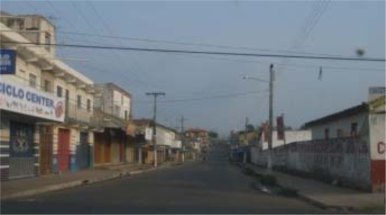
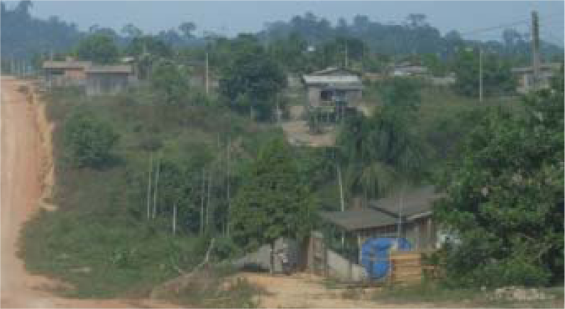
| Spatial Pattern | CBERS-CCD/HRC | Description | General appearance |
|---|---|---|---|
| Dense Occupation |  |
|  |
| Sparse occupation |  |
|  |
| Expansion areas | 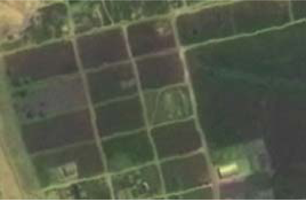 |
| 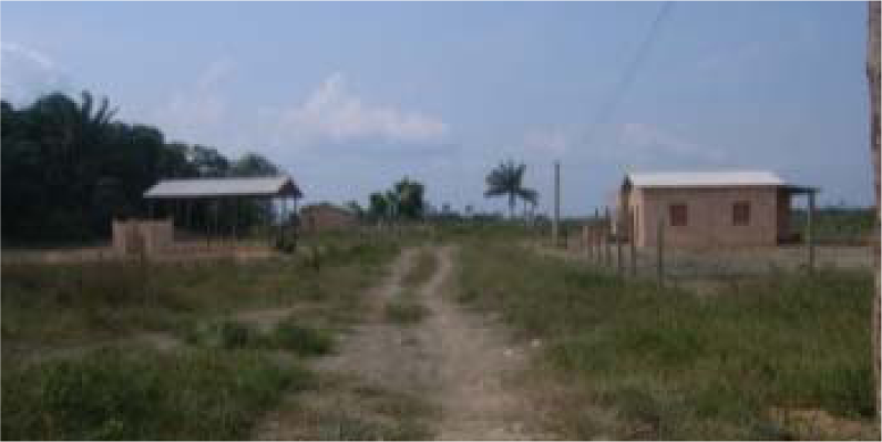 |
| Large non-residential constructions |  |
| 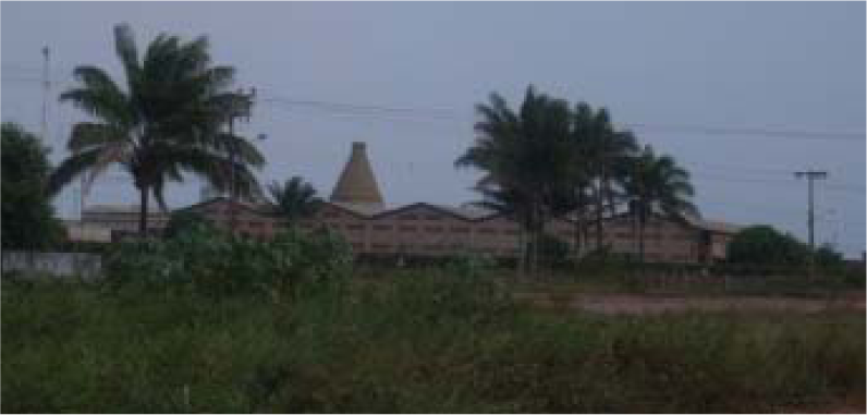 |
| Main access roads | 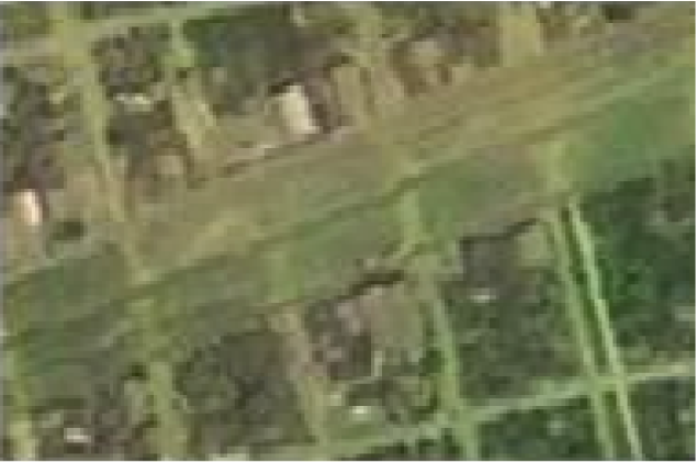 |
|  |
| Type of Census Tracts* | Classified | Verified | Visited (%) | Confirmed (%) | Minimum area classified (km2) | Maximum area classified (km2) | Total area (km2) |
|---|---|---|---|---|---|---|---|
| Urbanized area | 18 | 10 | 55.56 | 100 | 0.09 | 50.46 | 139.2 |
| Rural village | 16 | 13 | 81.25 | 100 | 0.09 | 3.90 | 89.0 |
| Rural zone | 95 | 38 | 40.00 | 97.36 | 0.05 | 2.37 | 89.5 |
| Special census tracts** | 4 | 1 | 25.00 | 100 | 0.11 | 0.38 | 0.8 |
| Total | 133 | 62 | 46.62 | 99.34 | - | - | 318.5 |
| Spatial Unit | Typology | Municipality | Foundation Date1 | Connectivity | Population | Category |
|---|---|---|---|---|---|---|
| Itaituba | City | Itaituba | 1856 | Tapajós River/BR230 road | 70,682* | Structured |
| Santarém | City | Santarém | 1848 | Tapajós, Amazonas River/BR163 road | 215,790* | Structured |
| Vila Bode2 | Community | Belterra | 1930–35 | side road | 413 | Established |
| Belterra | City | Belterra | 1947 | side road | 6,852* | Established |
| Betânia | Community | Belterra | 1975 | BR163 road | 200 | Recent |
| São Jorge | Community | Belterra | 1972 | side road | 3,000 | Recent |
| Itacimpasa | Community | Itaituba | side road | 600 | Recent | |
| Nova Esperança | Community | Itaituba | 1980 | BR163 road | 720 | Recent |
| Km 30 | Community | Itaituba | BR230 road | 1,666@ | Recent | |
| Jardim do Ouro | Community | Itaituba | 1984 | Transgarimpeira road | 500 to 600 | Recent |
| Riozinho das Arraias | Community | Novo Progresso | 1985 | BR163 road | 550 | Recent |
| Alvorada da Amazônia | Community | Novo Progresso | 1980 | BR163 road | 5,000 | Recent |
| Santa Júlia | Community | Novo Progresso | BR163 road | 33** | Recent | |
| Novo Paraíso | Community | Placas | BR163 road | 58** | Recent | |
| Estrela do Norte | Community | Rurópolis | 1981 | BR163 road | 240 | Recent |
| Água Azul | Community | Rurópolis | 1985 | BR163 road | 700 | Recent |
| Divinópolis | Community | Rurópolis | BR163 road | 2,464@ | Recent | |
| São José | Community | Rurópolis | BR163 road | 115** | Recent | |
| Boa Esperança | Community | Santarém | 1962 | side road | 3,500 | Recent |
| Tucunaré | Community | Trairão | BR163 road | 70 | Recent | |
| Bela Vista do Caracol | Community | Trairão | BR163 road | 7,200 | Recent | |
| Jamanxim | Community | Trairão | BR163 road | 1,200 | Recent | |
| TrêsBueiras | Community | Trairão | BR163 road | 28** | Recent | |
| Moraes Almeida | District | Itaituba | 2002 | BR163 road | 3,504@ | Recent |
| Miritituba | District | Itaituba | 1993 | Tapajós River / BR230 road | 4,500@ | Recent |
| Trairão | City | Trairão | 1991 | BR163 road | 5,679* | Recent |
| Novo Progresso | City | Novo Progresso | 1991 | BR163 road | 17,717* | Recent |
| Rurópolis | City | Rurópolis | 1988 | BR163 and BR320 roads | 15,273* | Recent |
| Aruri | Community | Itaituba | 1930 | BR163 road | 160 | Dependent |
| Nova Canaã | Community | Itaituba | 1930 | Tapajós River / BR230 road | 220 | Dependent |
| Taboca | Community | Santarém | side road | 15,455 | Dependent | |
| Mojuí dos Campos | District | Santarém | 1964 | side road | 5,940@ | Dependent |
Share and Cite
Dal’Asta, A.P.; Brigatti, N.; Amaral, S.; Sobral Escada, M.I.; Vieira Monteiro, A.M. Identifying Spatial Units of Human Occupation in the Brazilian Amazon Using Landsat and CBERS Multi-Resolution Imagery. Remote Sens. 2012, 4, 68-87. https://doi.org/10.3390/rs4010068
Dal’Asta AP, Brigatti N, Amaral S, Sobral Escada MI, Vieira Monteiro AM. Identifying Spatial Units of Human Occupation in the Brazilian Amazon Using Landsat and CBERS Multi-Resolution Imagery. Remote Sensing. 2012; 4(1):68-87. https://doi.org/10.3390/rs4010068
Chicago/Turabian StyleDal’Asta, Ana Paula, Newton Brigatti, Silvana Amaral, Maria Isabel Sobral Escada, and Antonio Miguel Vieira Monteiro. 2012. "Identifying Spatial Units of Human Occupation in the Brazilian Amazon Using Landsat and CBERS Multi-Resolution Imagery" Remote Sensing 4, no. 1: 68-87. https://doi.org/10.3390/rs4010068
APA StyleDal’Asta, A. P., Brigatti, N., Amaral, S., Sobral Escada, M. I., & Vieira Monteiro, A. M. (2012). Identifying Spatial Units of Human Occupation in the Brazilian Amazon Using Landsat and CBERS Multi-Resolution Imagery. Remote Sensing, 4(1), 68-87. https://doi.org/10.3390/rs4010068