Post-Disaster Image Processing for Damage Analysis Using GENESI-DR, WPS and Grid Computing
Abstract
:1. Introduction
- Disaster alert identifying location and disaster type is received (via online alerting system or government representative);
- Search and download pre-disaster imagery if available;
- Order/Acquire and download post-disaster imagery as soon as possible;
- Analyse pre- and post-disaster imagery to identify affected populated areas;
- Produce and disseminate maps and reports to stakeholders based on the most current available information.
1.1. GENESI-DR
1.2. Web Processing Service
1.3. Computing Power
1.4. Trust
2. A Review of the State-of-the-Art
2.1. WPS and Service Chaining
2.2. Trust and Security
3. Automating the Post-Disaster Image Processing Scenario
3.1. Scenario
3.2. Methodology
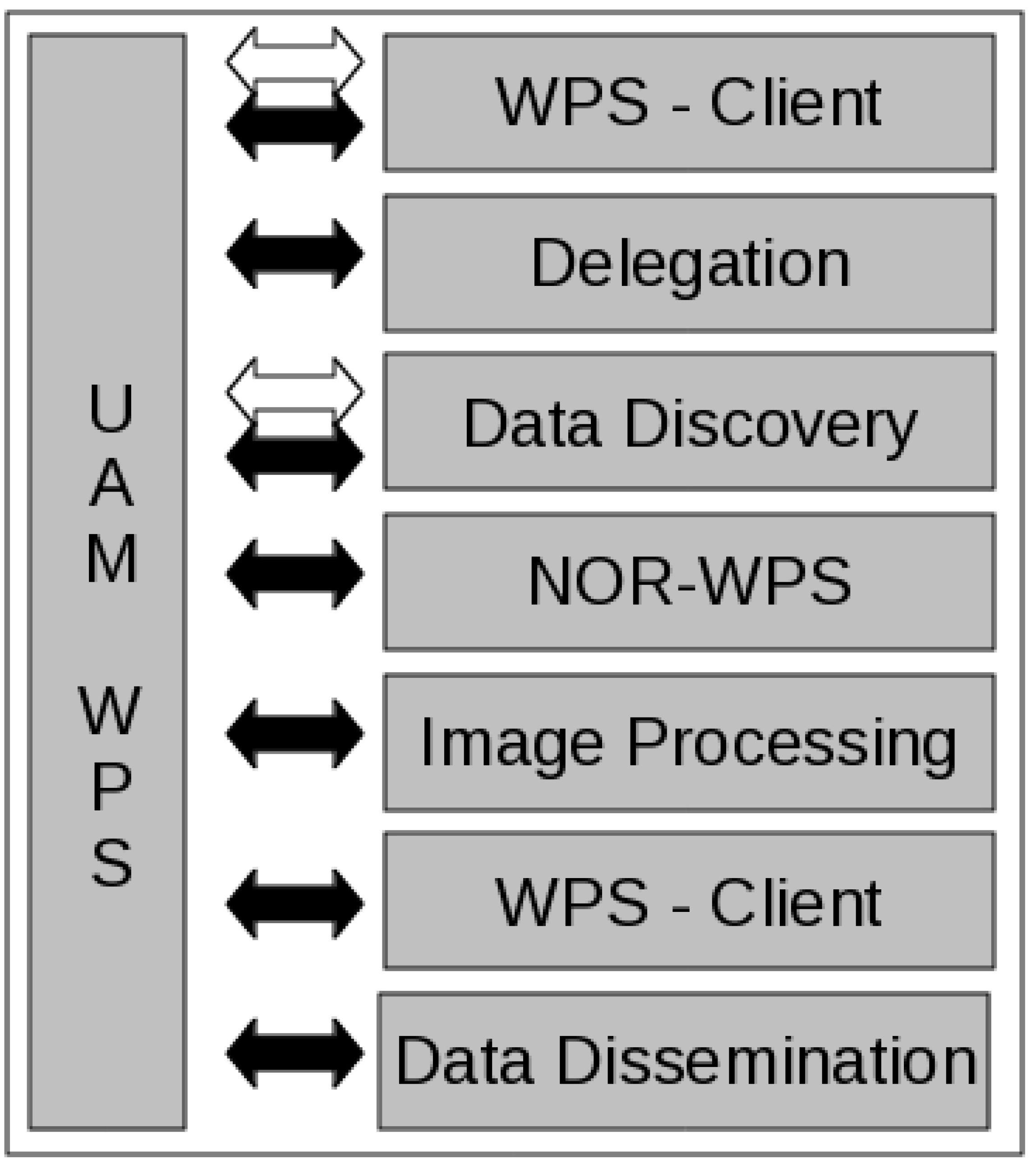
- The NOR and UAM applications were already regularly applied at the JRC but needed to be served via a WPS turning them into services;
- Trusted communication between the various clients and servers needed to be provided;
- The UAM application is computationally heavy and therefore access to a computing cluster was necessary and;
- An image upload/submission tool for GENESI-DR was developed to permit trusted dissemination of results.
4. Results


4.1. Scenario Description
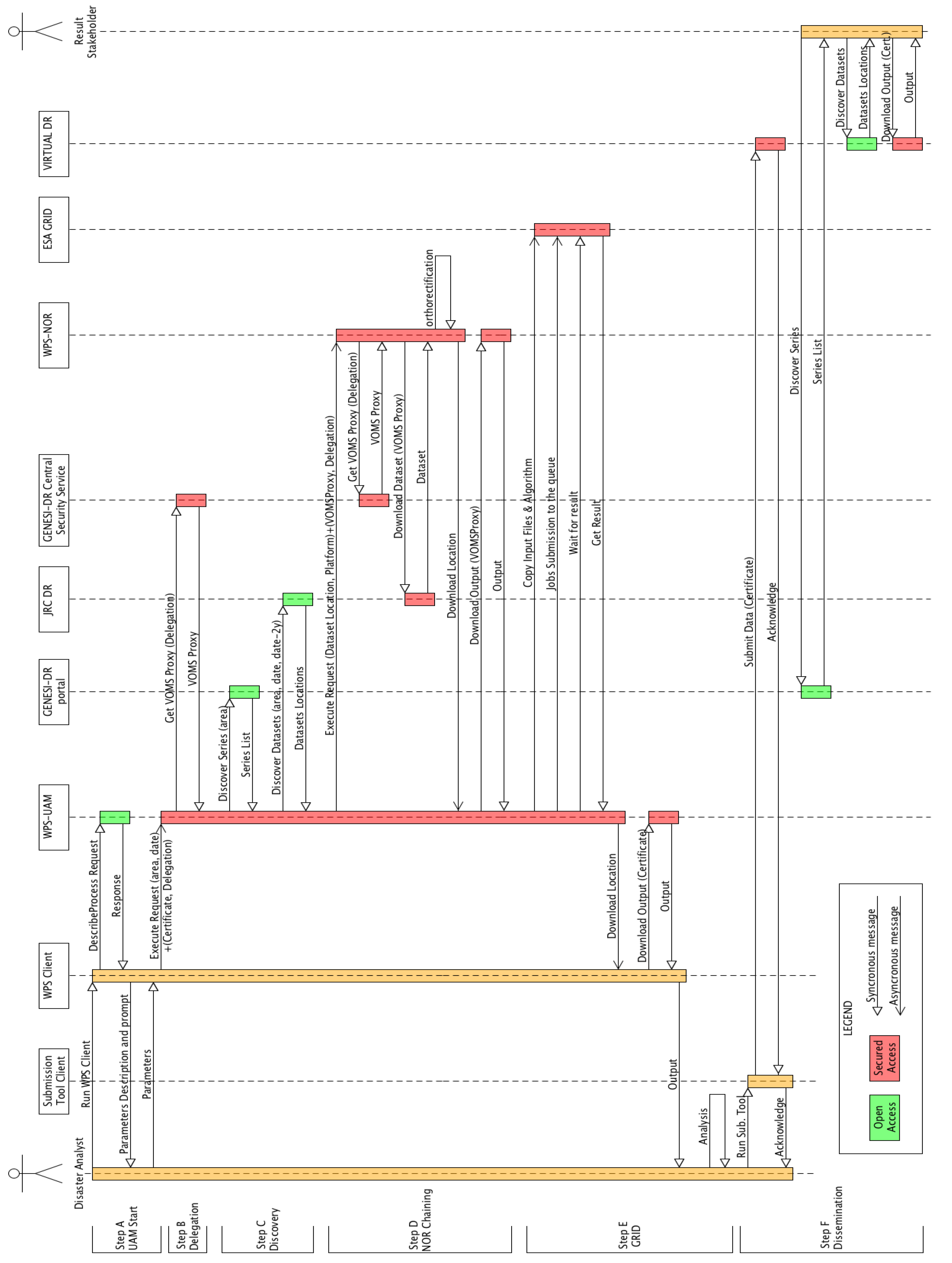
- The WPS Client. An ad-hoc simplified WPS client customized to perform GENESI-DR data discovery via the OpenSearch technologies (http://en.wikipedia.org/wiki/OpenSearch) and supporting the use of X.509 certificates for authentication was developed in Python (http://www.python.org/) applying the TDD technique.
- The JRC WPS Server. UAM and NOR were exposed as geospatial web services via the same server. The server machine was running the Debian Linux distribution with Apache as the web server. Two Apache modules were also required: mod-gridsite for X.509 certificates support and mod-Python for accessing HTTP(S) protocol objects via Python. PyWPS [24] provided the WPS v1.0.0 interface but the software layer between PyWPS and the underlying in-house developed applications needed to be developed and TDD was also applied.
- GENESI-DR (Discovery Service / Central Security Service). The GENESI-DR provided catalog discovery functionality via OpenSearch web syndication. OpenSearch, with the Geo and Time extensions developed within GENESI-DR, will be part of OGC CSW3.0 (currently being discussed in draft documents 09-084 and 10-032). The GENESI-DR Central Security Service is a server that provides VOMS proxies for authorisation delegation as well as stores information linking users to Virtual Organisations.
- Digital Repositories (JRC DR, Virtual DR). The Digital Repositories in GENESI-DR provide secure access to geospatial datasets and include the GENESI catalogue generator, discovery agent, data catalogue, and catalogue access service. The JRC CID DR is GENESI-DR compliant and serves a subset of the data available from the CID Portal (http://cidportal.jrc.ec.europa.eu/imagearchive/main/). The Virtual Digital Repository was set up specifically for this demo and is a standard GENESI-DR Digital Repository used to show the possibilities of secured and remote dissemination.
- On Demand Grid Processing. ESA provided access to their computing grid which is also part of the European Grid Infrastructure (http://www.egi.eu/). Processing jobs were submitted using the GridWay (http://www.gridway.org) metascheduler providing access to machines running Scientific Linux. The UAM binaries and input imagery were submitted in this manner based on a bash script prepared by the WPS.
4.2. Test Driven Development
- A test for new functionality is written and making sure the test fails;
- The production code to pass the test is written making the test succeed;
- The code is refactored, removing duplication and making it more readable. The updated version is re-tested to be sure that nothing was broken during refactoring.
4.3. Service Activity
5. Conclusions and Discussion
- The GENESI-DR infrastructure provided the image discovery functionality and secure authorized access to imagery from a variety of data owners as well as dissemination to authorized partners.
- The WPS standard provided a controlled “self service” to users and stakeholders which presented the required credentials and possessed the needed permissions. This service means that people anywhere can have access to the services whenever they are required and tailor them to their particular needs.
- Grid computing infrastructures both in Europe and across the globe provide on-demand access to high performance computing clusters.
- Web security and authorization provided a secure way of communicating and authorizing services.
Acknowledgements
References
- Ground European Network for Earth Science Interoperations-Digital Repositories (GENESI-DR). 2010. Available online: http://www.genesi-dec.eu/ (accessed on 28 April 2011).
- European Commission FP7 Project Page for GENESI-DR. Available online: http://cordis.europa.eu/fetch?CALLER=FP7_PROJ_EN&ACTION=D&DOC=1&CAT=PROJ&RCN=86424 (accessed on 27 April 2011).
- Burger, A.; Hasenohr, P.; Åstrand, P.J. Providing Access to Terabytes of Earth Observation Data—Infrastructure, Services, and Licensing. In Proceedings of 14th MARS Annual Conference “Geomatics in support of the CAP”, Ljubljana, Slovenia, 3–5 December 2008.
- Westin, T.; Edgardh, L.A. Automatic Model Adjustment to Reference Data Sets. 2006. Available online: http://www.spacemetric.com (accessed on 27 April 2011).
- Schut, P. OpenGIS Web Processing Service (WPS) 1.0.0; 05-007r7; Open Geospatial Consortium Inc.: Wayland, MA, USA, 2007; Available online: http://www.opengeospatial.org/standards/wps (accessed on 28 April 2011).
- Pesaresi, M.; Gerhardinger, A.; Kayitakire, F. A robust built-up area presence index by anisotropic rotation-invariant textural measure. IEEE J. Sel. Topics Appl. Earth Obs. Remote Sens. 2008, 1, 180–192. [Google Scholar] [CrossRef]
- Stokes, J. Amazon goes from cloud to grid with new cluster product. Ars Technica. 2010. Available online: http://arstechnica.com/business/news/2010/07/amazon-goes-grid-with-cluster-compute-instances-for-ec2.ars (accessed on 27 April 2011).
- Stokes, J. The cloud: A short introduction. Ars Technica. 2009. Available online: http://arstechnica.com/business/news/2009/11/the-cloud-a-short-introduction.ars (accessed on 27 April 2011).
- Brauner, J.; Foerster, T.; Schaeffer, B.; Baranski, B. Towards a Research Agenda for Geoprocessing Services. In Proceedings of 12th AGILE International Conference on Geographic Information Science, Hannover, Germany, 2–5 June 2009.
- Khalsa, S.J.; Percivall, G. Geoscience depends on geospatial information standards. IEEE Geosci. Remote Sens. Soc. Newslett. 2010, 12, 18–22. [Google Scholar]
- Gehlot, S.; Verbree, E. Web-Based Sharing of a Geo-Processing Chain: Combination and Dissemination of Data and Services. In Proceedings of The International Symposium on Geospatial Databases for Sustainable Development/ISPRS TC Commitee IV Geo-Databases and Digital Mapping, Goa, India, 25–30 September 2006.
- Foerster, T.; Schaeffer, B.; Brauner, J.; Jirka, S. Integrating OGC Web Processing Services into Geospatial Mass-Market Applications. In Proceedings of The International Conference on Advanced Geographic Information Systems & Web Services, Cancun, Mexico, 1–6 February 2009.
- Granell, C.; Diaz, L.; Gould, M. Managing Earth Observation Data with Distributed Geoprocessing Services. In Proceedings of The International Geoscience and Remote Sensing Symposium (IGARSS 2007), Barcelona, Spain, 23–27 July 2007; pp. 4777–4780.
- Schaeffer, B. Towards a Transactional Web Processing Service (WPS-T). In Proceedings of GI-Days 2008: The 6th Geographic Information Days, Muenster, Germany, 16–18 June 2008; Volume 32.
- Stöllberg, B.; Zipf, A. Development of a WPS Process Chaining Tool and Application in a Disaster Management Use Case for Urban Areas. In Proceedings of 27th Urban Data Management Symposium (UDMS 2009), Ljubljana, Slovenija, 24–26 June 2009.
- Christensen, E.; Curbera, F.; Meredith, G.; Weerawarana, S. Web Services Description Language (WSDL) 1.1. W3C Note; The World Wide Web Consortium (W3C), 15 March 2001. Available online: http://www.w3.org/TR/wsdl (accessed on 28 April 2011).
- Walenciak, G.; Stöllberg, B.; Neubauer, S.; Zipf, A. Extending Spatial Data Infrastructures 3D by Geoprocessing Functionality—3D Simulations in Disaster Management and environmental Research. In Proceedings of The International Conference on Advanced Geographic Information Systems & Web Services, Cancun, Mexico, 1–6 February 2009.
- Stöllberg, B.; Zipf, A. OGC Web Processing Service Interface for Web Service Orchestration Aggregating Geo-processing Services in a Bomb Threat Scenario. Lecture Notes Comput. Sci. 2007, 4857, 239–251. [Google Scholar]
- Lanig, S.; Schiling, A.; Stöllberg, B.; Zipf, A. Towards Standards-based Processing of Digital Elevation Models for Grid Computing through Web Processing Service (WPS). In Proceedings of The 2008 International Conference on Computational Science and its Applications (ICCSA2008), Hong Kong, 19–21 March 2008.
- Box, D.; Ehnebuske, D.; Kakivaya, G.; Layman, A.; Mendelsohn, N.; Nielsen, H.F.; Thatte, S.; Winer, D. Simple Object Access Protocol (SOAP) 1.1; W3C Note; The World Wide Web Consortium (W3C): 8 May 2000; Available online: http://www.w3.org/TR/2000/NOTESOAP20000508/ (accessed on 28 April 2011).
- Hobona, G.E.; Fairbairn, D.; James, P.M. Workflow Enactment of Grid-Enabled Geospatial Web Services. In Proceedings of the UK e-Science All Hands Meeting, Nottingham, UK, 10–13 September 2007.
- Baranski, B. Grid Computing Enabled Web Processing Service. In Proceedings of GI-Days 2008: The 6th Geographic Information Days, Muenster, Germany, 16–18 June 2008; Volume 32.
- Friis-Christensen, A.; Ostländer, N.; Lutz, M.; Bernard, L. Designing service architectures for distributed geoprocessing: Challenges and future directions. Trans. GIS 2007, 11, 799–818. [Google Scholar] [CrossRef]
- Cepicky, J.; Becchi, L. Geospatial Processing via Internet on Remote Servers PyWPS. OSGeo J. 2007, 1, 39–42. Available online: http://www.osgeo.org/ojs/index.php/journal/issue/view/17 (accessed on 27 April 2011). [Google Scholar]
- Liu, J.; Sun, J.; Xu, Z.Q. Secure distribution for high resolution remote sensing images. J. Appl. Remote Sens. 2010, 4, 1–12. [Google Scholar] [CrossRef]
- Lanig, S.; Zipf, A. Interoperable processing of digital elevation models in grid infrastructures. Earth Sci. Inf. 2009, 2, 107–116. [Google Scholar] [CrossRef]
- Foster, I. Globus Toolkit Version 4: Software for service-oriented systems. In IFIP International Conference on Network and Parallel Computing; LNCS 2779; Springer-Verlag: Berlin/Heidelberg, Germany, 2005; pp. 2–13. [Google Scholar]
- Moses, T. PKI trust models. In IT-University of Copenhagen Course Material; IT-University of Copenhagen: Copenhagen, Denmark, 2003; Available online: http://www.itu.dk/courses/DSK/E2003/DOCS/PKI_Trust_models.pdf (accessed on 1 May 2011).
- Infrastructure for Spatial Information in the European Community (INSPIRE). Official J. Europ. Union. 14 March 2007. Available online: http://eurlex.europa.eu/LexUriServ/LexUriServ.do?uri=OJ:L:2007:108:0001:0014:EN:PDF (accessed on 28 April 2011).
- Beck, K. Test Driven Development: By Example; Addison-Wesley Professional: Boston, MA, USA, 2002. [Google Scholar]
- Kerle, M. Satellite-based damage mapping following the 2006 Indonesia earthquake—How accurate was it? Int. J. Appl. Earth Obs. Geoinf. 2010, 6, 466–476. [Google Scholar] [CrossRef]
© 2011 by the authors; licensee MDPI, Basel, Switzerland. This article is an open access article distributed under the terms and conditions of the Creative Commons Attribution license (http://creativecommons.org/licenses/by/3.0/.)
Share and Cite
Bielski, C.; Gentilini, S.; Pappalardo, M. Post-Disaster Image Processing for Damage Analysis Using GENESI-DR, WPS and Grid Computing. Remote Sens. 2011, 3, 1234-1250. https://doi.org/10.3390/rs3061234
Bielski C, Gentilini S, Pappalardo M. Post-Disaster Image Processing for Damage Analysis Using GENESI-DR, WPS and Grid Computing. Remote Sensing. 2011; 3(6):1234-1250. https://doi.org/10.3390/rs3061234
Chicago/Turabian StyleBielski, Conrad, Simone Gentilini, and Marco Pappalardo. 2011. "Post-Disaster Image Processing for Damage Analysis Using GENESI-DR, WPS and Grid Computing" Remote Sensing 3, no. 6: 1234-1250. https://doi.org/10.3390/rs3061234
APA StyleBielski, C., Gentilini, S., & Pappalardo, M. (2011). Post-Disaster Image Processing for Damage Analysis Using GENESI-DR, WPS and Grid Computing. Remote Sensing, 3(6), 1234-1250. https://doi.org/10.3390/rs3061234


