Evaluating Spectral Indices for Assessing Fire Severity in Chaparral Ecosystems (Southern California) Using MODIS/ASTER (MASTER) Airborne Simulator Data

Abstract
:1. Introduction
2. Methodology
2.1. Study Area

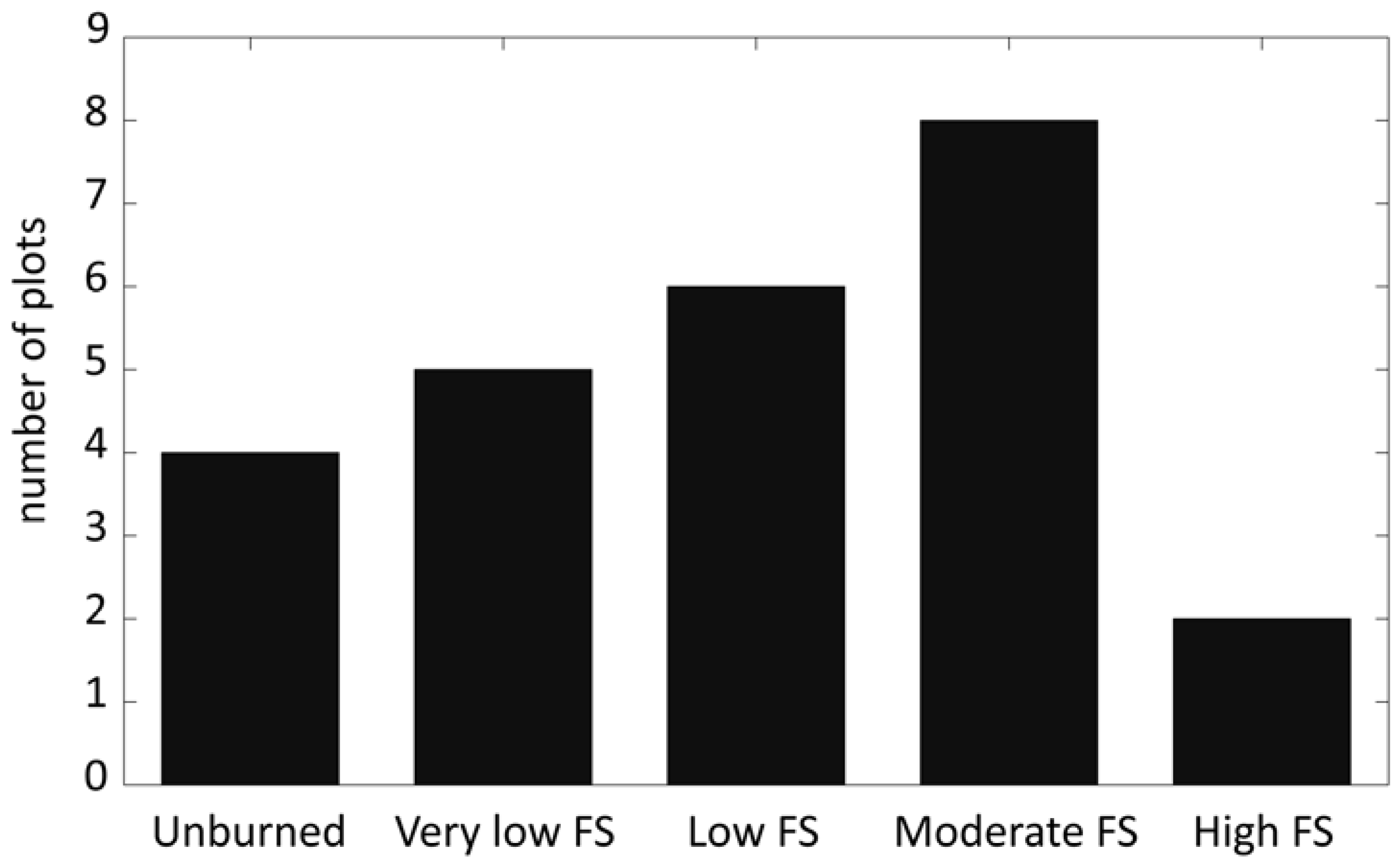
2.2. Field Data

| Fire severity Class | Substrate | Vegetation |
|---|---|---|
| Unburned (1) | Not burned | Not burned |
| Very low (2) | Litter partially blackened; duff nearly unchanged; wood/leaf structures unchanged | Foliage scorched and attached to supporting twigs |
| Low (3) | Litter charred to partially consumed, some leaf structure undamaged; surface is predominantly black; some gray ash may be present immediately postburn; charring may extend slightly into soil surface where litter is sparse, otherwise soil is not altered | Foliage and smaller twigs partially to completely consumed; branches mostly intact; less than 60% of the shrub canopy is commonly consumed |
| Moderate (4) | Leaf litter consumed, leaving coarse, light colored ash; duff deeply charred, but underlying mineral soil is not visibly altered; woody debris is mostly consumed; logs are deeply charred, burned-out stump holes are common | Foliage, twigs, ands small stems consumed; some branches (>0.6–1 cm in diameter) still present; 40–80% of the shrub canopy is commonly consumed |
| High (5) | Leaf litter completely consumed, leaving a fluffy fine white ash; all organic material is consumed in mineral soil to a depth of 1–2.5 cm, this is underlain by a zone of black organic material; colloidal structure of the surface mineral soil may be altered | All plant parts consumed leaving only stubs greater than 1 cm in diameter |
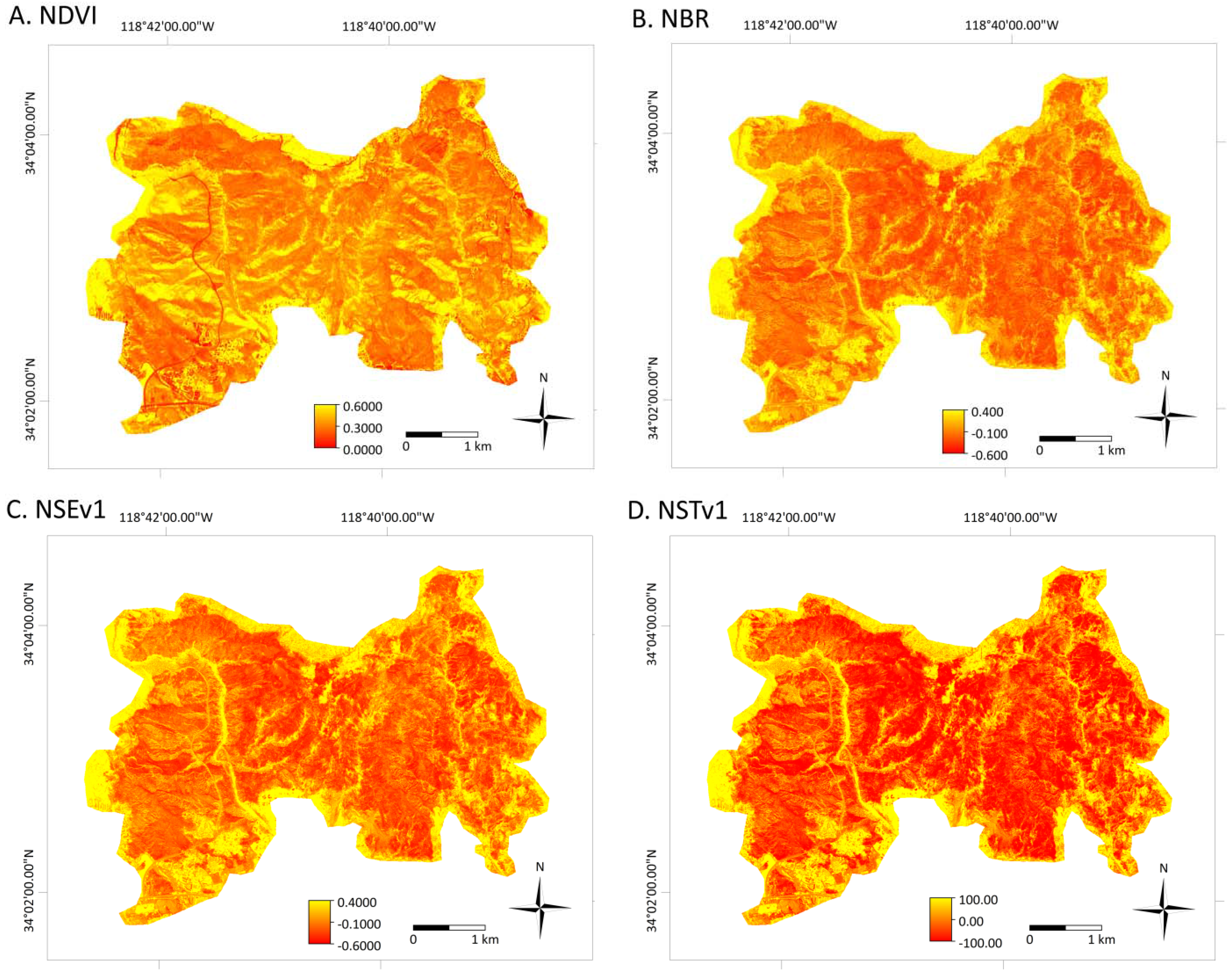
2.3. MASTER Imagery and Preprocessing
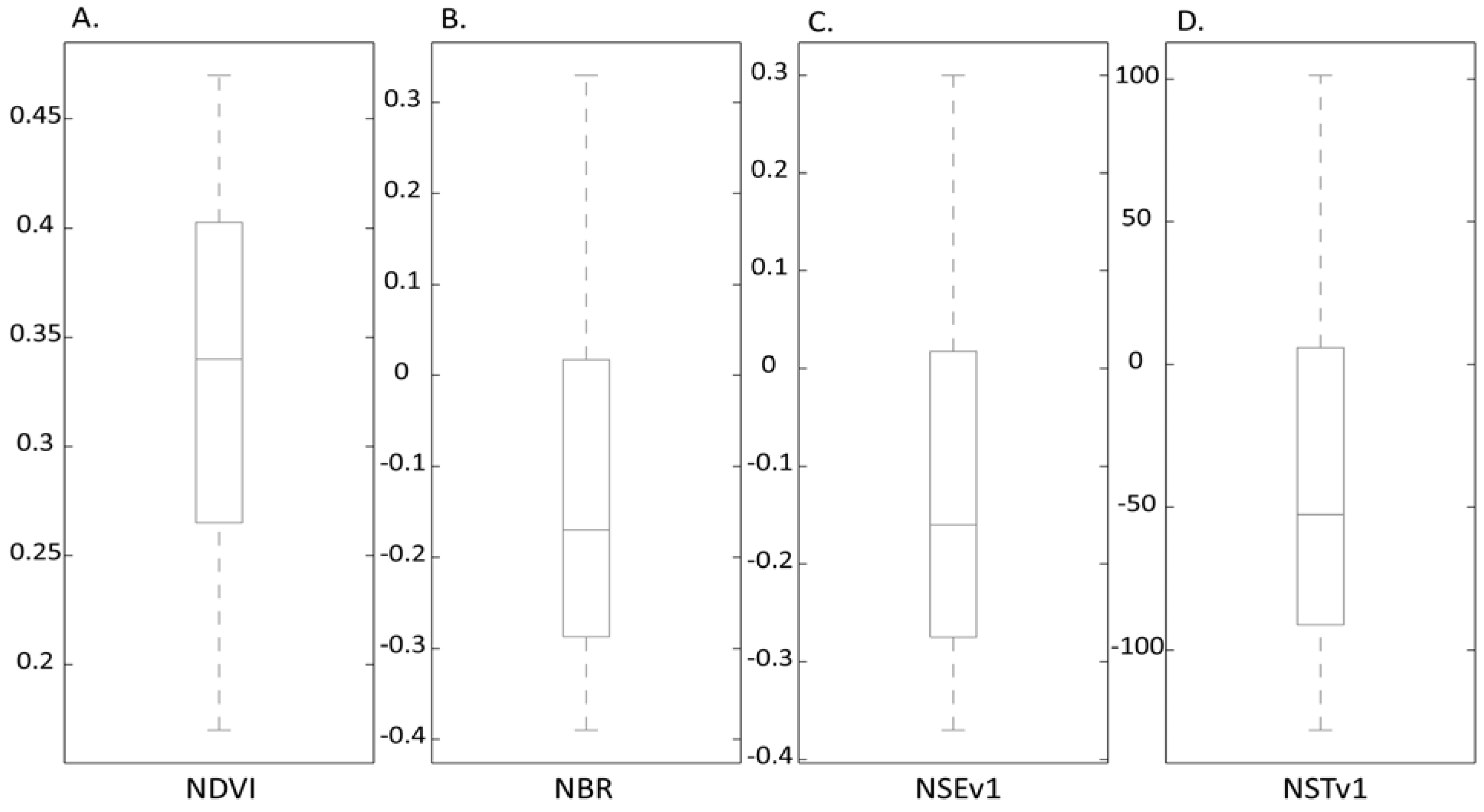
2.4. Spectral Indices
| Index | Abbreviation and Reference | Formula |
|---|---|---|
| Normalized Difference Vegetation Index | NDVI [57] | |
| Global Environment Monitoring Index | GEMI [58] | with |
| Enhanced Vegetation Index | EVI [59] | |
| Vegetation Index 3 | VI3 [67] | |
| Soil Adjusted Vegetation Index | SAVI [60] | with L = 0.5 |
| Modified Soil Adjusted Vegetation Index | MSAVI [61] | |
| Burned Area Index | BAI [62] | |
| Global Environment Monitoring Index 3 | GEMI3 [63] | with |
| Normalized Burn Ratio | NBR [27] | |
| Char Soil Index | CSI [64] | |
| Mid InfraRed Burn Index | MIRBI [65] | |
| Normalized Difference Vegetation Index Thermal | NDVIT [47] | . |
| Soil Adjusted Vegetation Index Thermal | SAVIT [47] | with L = 0.5 |
| Normalized Burn Ratio Thermal | NBRT [46] | |
| Vegetation Index 6 Thermal | VI6T [46] | |
| NIR-SWIR-Emissivity Version 1 | NSEv1 [48] | |
| NIR-SWIR-Emissivity Version 2 | NSEv2 [48] | |
| NIR-SWIR-Temperature Version 1 | NSTv1 [48] | |
| NIR-SWIR-Temperature Version 2 | NSTv2 [48] |
2.5. Logistic Regression Analysis
3. Results and Discussion
| Spectral Index | Deviance (D) |
|---|---|
| NSTv1 | 64.24 |
| NBR | 64.34 |
| NSEv1 | 64.50 |
| NSEv2 | 64.55 |
| CSI | 66.77 |
| NBRT | 67.81 |
| SAVI | 70.26 |
| VI3 | 70.68 |
| NDVI | 71.15 |
| NDVIT | 72.27 |
| NSTv2 | 73.59 |
| SAVIT | 73.91 |
| GEMI | 73.94 |
| GEMI3 | 74.36 |
| VI6T | 74.53 |
| BAI | 74.76 |
| EVI | 74.83 |
| MIRBI | 76.19 |
| MSAVI | 76.19 |

4. Conclusions
Acknowledgments
References
- Morgan, P.; Hardy, C.; Swetnam, T.; Rollins, M.; Long, D. Mapping fire regimes across time and space: understanding coarse and fine scale fire patterns. Int. J. Wildland Fire 2001, 10, 329–343. [Google Scholar] [CrossRef]
- Keeley, J. Fire intensity, fire severity and burn severity: A brief review and suggested usage. Int. J. Wildland Fire 2009, 18, 116–126. [Google Scholar] [CrossRef]
- Hammill, K.; Bradstock, R. Remote sensing of fire severity in the Blue Mountains: Influence of vegetation type and inferring fire intensity. Int. J. Wildland Fire 2006, 15, 213–226. [Google Scholar] [CrossRef]
- Gonzalez-Alonso, F.; Merino-De-Miguel, S.; Roldan-Zamarron, A.; Garcia-Gigorro, S.; Cuevas, J. MERIS Full Resolution data for mapping level-of-damage caused by forest fires: The Valencia de Alcántara event in August 2003. Int. J. Remote Sens. 2007, 28, 789–809. [Google Scholar] [CrossRef]
- Chafer, C. A comparison of fire severity measures: An Australian example and implications for predicting major areas of soil erosion. Catena 2008, 74, 235–245. [Google Scholar] [CrossRef]
- Landmann, T. Characterizing sub-pixel Landsat ETM+ fire severity on experimental fire in the Kruger National Park, South Africa. South Afr. J. Sci. 2003, 99, 357–359. [Google Scholar]
- Chafer, C.; Noonan, M.; Macnaught, E. The post-fire measurement of fire severity and intensity in the Christmas 2001 Sydney wildfires. Int. J. Wildland Fire 2004, 13, 227–240. [Google Scholar] [CrossRef]
- Cocke, A.; Fule, P.; Crouse, J. Comparison of burn severity assessments using Differenced Normalized Burn Ratio and ground data. Int. J. Wildland Fire 2005, 14, 189–198. [Google Scholar] [CrossRef]
- Stow, D.; Petersen, A.; Rogan, J.; Franklin, J. Mapping burn severity of Mediterranean-type vegetation using satellite multispectral data. GISci. Remote Sens. 2007, 44, 1–23. [Google Scholar] [CrossRef]
- Lee, B.; Kim, S.; Chung, J.; Park, P. Estimation of fire severity by use of Landsat TM images and its relevance to vegetation and topography in the 2000 Samcheok forest fire. J. Forest Res. 2008, 13, 197–204. [Google Scholar] [CrossRef]
- Brewer, K.; Winne, C.; Redmond, R.; Opitz, D.; Mangrich, M. Classifying and mapping wildfire severity: A comparison of methods. Photogramm. Eng. Remote Sensing 2005, 71, 1311–1320. [Google Scholar] [CrossRef]
- Eidenshink, J.; Schwind, B.; Brewer, K.; Zhu, Z.; Quayle, B.; Howard, S. A project for monitoring trends in burn severity. Fire Ecol. 2007, 3, 3–21. [Google Scholar] [CrossRef]
- Lentile, L.; Holden, Z.; Smith, A.; Falkowski, M.; Hudak, A.; Morgan, P.; Lewis, S.; Gessler, P.; Benson, N. Remote sensing techniques to assess active fire characteristics and post-fire effects. Int. J. Wildland Fire 2006, 15, 319–345. [Google Scholar] [CrossRef]
- Veraverbeke, S.; Lhermitte, S.; Verstraeten, W.W.; Goossens, R. The temporal dimension of differenced Normalized Burn Ratio (dNBR) fire/burn severity studies: The case of the large 2007 Peloponnese wildfires in Greece. Remote Sens. Environ. 2010, 114, 2548–2563. [Google Scholar] [CrossRef]
- Jain, T.; Pilliod, D.; Graham, R. Tongue-tied. Wildfire 2004, 4, 22–26. [Google Scholar]
- Andreae, M.; Crutzen, P. Atmospheric aerosols: Biogeochemical sources and role in atmospheric chemistry. Science 1997, 276, 1052–1058. [Google Scholar] [CrossRef]
- Chuvieco, E.; Riano, D.; Danson, F.; Martin, P. Use of a radiative transfer model to simulate the postfire spectral response to burn severity. J. Geophys. Res. 2006, 111, G04S09. [Google Scholar] [CrossRef]
- De Santis, A.; Chuvieco, E. Severity estimation from remotely sensed data: Performance of simulation versus empirical models. Remote Sens. Environ. 2007, 108, 422–435. [Google Scholar] [CrossRef]
- De Santis, A.; Chuvieco, E.; Vaughan, P. Short-term assessment of burn severity using the inversion of PROSPECT and GeoSail models. Remote Sens. Environ. 2009, 113, 126–136. [Google Scholar] [CrossRef]
- De Santis, A.; Asnser, G.; Vaughan, P.; Knapp, D. Mapping burn severity and burning efficiency in California using simulation models and Landsat imagery. Remote Sens. Environ. 2010, 114, 1535–1545. [Google Scholar] [CrossRef]
- Rogan, J.; Yool, S. Mapping fire-induced vegetation depletion in the Peloncillo mountains, Arizona and New Mexico. Int. J. Remote Sens. 2001, 16, 3101–3121. [Google Scholar] [CrossRef]
- Lewis, S.; Lentile, L.; Hudak, A.; Robichaud, P.; Morgan, P.; Bobbitt, M. Mapping ground cover using hyperspectral remote sensing after the 2003 Simi and Old wildfires in Southern California. Fire Ecol. 2007, 3, 109–128. [Google Scholar] [CrossRef]
- Robichaud, P.; Lewis, S.; Laes, D.; Hudak, A.; Kokaly, R.; Zamudio, J. Post-fire soil burn severity mapping with hyperspectral image unmixing. Remote Sens. Environ. 2007, 108, 467–480. [Google Scholar] [CrossRef]
- Rogan, J.; Franklin, J. Mapping wildfire burn severity in southern California forests and shrublands using Enhanced Thematic Mapper imagery. Geocarto Int. 2001, 16, 1–11. [Google Scholar] [CrossRef]
- Lopez-Garcia, M.; Caselles, V. Mapping burns and natural reforestation using Thematic Mapper data. Geocarto Int. 1991, 6, 31–37. [Google Scholar] [CrossRef]
- Epting, J.; Verbyla, D.; Sorbel, B. Evaluation of remotely sensed indices for assessing burn severity in interior Alaska using Landsat TM and ETM+. Remote Sens. Environ. 2005, 96, 328–339. [Google Scholar] [CrossRef]
- Key, C.; Benson, N. Landscape assessment: Ground measure of severity; The Composite Burn Index, and remote sensing of severity, the Normalized Burn Index. In FIREMON: Fire Effects Monitoring and Inventory System; Lutes, D., Keane, R., Caratti, J., Key, C., Benson, N., Sutherland, S., Gangi, L., Eds.; Rocky Mountains Research Station, USDA Forest Service: Fort Collins, CO, USA, 2005; pp. 1–51. [Google Scholar]
- Ju, J.; Roy, D. The availability of cloud-free Landsat ETM+ data over the conterminous United States and globally. Remote Sens. Environ. 2008, 112, 1196–1211. [Google Scholar] [CrossRef]
- Veraverbeke, S.; Lhermitte, S.; Verstraeten, W.W.; Goossens, R. Illumination effects on the differenced Normalized Burn Ratio’s optimality for assessing fire severity. Int. J. Appl. Earth Obs. Geoinf. 2010, 12, 60–70. [Google Scholar] [CrossRef]
- Verbyla, D.; Kasischke, E.; Hoy, E. Seasonal and topographic effects on estimating fire severity from Landsat TM/ETM+ data. Int. J. Wildland Fire 2008, 17, 527–534. [Google Scholar] [CrossRef]
- French, N.; Kasischke, E.; Hall, R.; Murphy, K.; Verbyla, D.; Hoy, E.; Allen, J. Using Landsat data to assess fire and burn severity in the North American boreal forest region: An overview and summary of results. Int. J. Wildland Fire 2008, 17, 443–462. [Google Scholar] [CrossRef]
- Veraverbeke, S.; Verstraeten, W.W.; Lhermitte, S.; Goossens, R. Evaluating Landsat Thematic Mapper spectral indices for estimating burn severity of the 2007 Peloponnese wildfires in Greece. Int. J. Wildland Fire 2010, 19, 558–569. [Google Scholar] [CrossRef]
- Veraverbeke, S.; Lhermitte, S.; Verstraeten, W.W.; Goossens, R. Evaluation of pre/post-fire differenced spectral indices for assessing burn severity in a Mediterranean environment with Landsat Thematic Mapper. Int. J. Remote Sens. 2011, 32, 3521–3537. [Google Scholar] [CrossRef]
- Cocke, A.; Fule, P.; Crouse, J. Comparison of burn severity assessments using Differenced Normalized Burn Ratio and ground data. Int. J. Wildland Fire 2005, 14, 189–198. [Google Scholar] [CrossRef]
- Fox, D.; Maselli, F.; Carrega, P. Using SPOT images and field sampling to map burn severity and vegetation factors affecting post forest fire erosion risk. Catena 2008, 75, 326–335. [Google Scholar] [CrossRef]
- Miller, J.; Yool, S. Mapping forest post-fire canopy consumption in several overstory types using multi-temporal Landsat TM and ETM data. Remote Sens. Environ. 2002, 82, 481–496. [Google Scholar] [CrossRef]
- van Wagtendonk, J.; Root, R.; Key, C. Comparison of AVIRIS and Landsat ETM+ detection capabilities for burn severity. Remote Sens. Environ. 2004, 92, 397–408. [Google Scholar] [CrossRef]
- White, J.; Ryan, K.; Key, C.; Running, S. Remote sensing of forest fire severity and vegetation recovery. Int. J. Wildland Fire 1996, 6, 125–136. [Google Scholar] [CrossRef]
- Keeley, J.; Brennan, T.; Pfaff, A. Fire severity and ecosystem responses following fires in California shrublands. Ecol. Appl. 2008, 18, 1530–1546. [Google Scholar] [CrossRef] [PubMed]
- Peterson, S.; Moritz, M.; Morais, M.; Dennison, P.; Carlson, J. Modelling long-term fire regimes of southern California shrublands. Int. J. Wildland Fire 2011, 20, 1–16. [Google Scholar] [CrossRef]
- Westerling, A.; Bryant, B. Climate change and wildfire in California. Climatic Change 2008, 87 Suppl. 1, S231–S249. [Google Scholar] [CrossRef]
- Escuin, S.; Navarro, R.; Fernandez, P. Fire severity assessment by using NBR (Normalized Burn Ratio) and NDVI (Normalized Difference Vegetation Index) derived from LANDSAT TM/ETM images. Int. J. Remote Sens. 2008, 29, 1053–1073. [Google Scholar] [CrossRef]
- Tanase, M.; Perez-Cabello, F.; de la Riva, J.; Santoro, M. TerraSAR-X data for burn severity evaluation in Mediterranean forest on sloped terrain. IEEE Trans. Geosci. Remote Sens. 2010, 48, 917–929. [Google Scholar] [CrossRef]
- Cahoon, D.; Stocks, B.; Levine, J.; Cofer, W.; Pierson, J. Satellite analysis of the severe 1987 forest fires in northern China and Southeastern Siberia. J. Geophys. Res. 1994, 99, 627–638. [Google Scholar] [CrossRef]
- Lambin, E.; Goyvaerts, K.; Petit, C. Remotely-sensed indicators of burning efficiency of savannah and forest fires. Int. J. Remote Sens. 2003, 24, 3105–3118. [Google Scholar] [CrossRef]
- Holden, Z.; Smith, A.; Morgan, P.; Rollins, M.; Gessler, P. Evaluation of novel thermally enhanced spectral indices for mapping fire perimeters and comparisons with fire atlas data. Int. J. Remote Sens. 2005, 26, 4801–4808. [Google Scholar] [CrossRef]
- Smith, A.; Drake, N.; Wooster, M.; Hudak, A.; Holden, Z.; Gibbons, C. Production of Landsat ETM+ reference imagery of burned areas within Southern African savannahs: Comparison of methods and application to MODIS. Int. J. Remote Sens. 2007, 28, 2753–2775. [Google Scholar] [CrossRef]
- Veraverbeke, S.; Harris, S.; Hook, S. Evaluating spectral indices for burned area discrimination using MODIS/ASTER (MASTER) airborne simulator data. Remote Sens. Environ. 2011, 115, 2702–2709. [Google Scholar] [CrossRef]
- Hook, S.; Myers, J.; Thome, K.; Fitzgerald, M.; Kahle, A. The MODIS/ASTER airborne simulator (MASTER)—A new instrument for earth science studies. Remote Sens. Environ. 2001, 76, 93–102. [Google Scholar] [CrossRef]
- Minnich, R. Fire mosaics in southern California and northern Baja California. Science 1983, 213, 1287–1294. [Google Scholar] [CrossRef] [PubMed]
- Keeley, J. Impact of antecedent climate on fire regimes in coastal California. Int. J. Wildland Fire 2004, 13, 173–182. [Google Scholar] [CrossRef]
- USDI National Park Service. Fire Monitoring Handbook; Fire Management Program Center, National Interagency Fire Center: Boise, ID, USA, 2003; pp. 1–274. [Google Scholar]
- Richter, R. Atmospheric/Topographic Correction for Airborne Imagery. ATCOR-4 User Guide; Version 5.0; DLR-German Aerospace Center, Remote Sensing Data Center: Wessling, Germany, 2009; pp. 1–90. [Google Scholar]
- Hook, S.; Gabell, A.; Green, A.; Kealy, P. A comparison of techniques for extracting emissivity information from thermal infrared data for geologic studies. Remote Sens. Environ. 1992, 42, 123–135. [Google Scholar] [CrossRef]
- Norman, J.; Becker, F. Terminology in thermal infrared remote-sensing of natural surfaces. Agr. Forest Meteorol. 1995, 77, 153–156. [Google Scholar] [CrossRef]
- Hulley, G.; Hook, S. The North American Land Surface Emissivity Database (NAALSED) Version 2.0. Remote Sens. Environ. 2009, 113, 1967–1975. [Google Scholar] [CrossRef]
- Tucker, C. Red and photographic infrared linear combinations for monitoring vegetation. Remote Sens. Environ. 1979, 8, 127–150. [Google Scholar] [CrossRef]
- Pinty, B.; Verstraete, M. GEMI—A nonlinear index to monitor global vegetation from satellites. Vegetatio 1992, 101, 15–20. [Google Scholar] [CrossRef]
- Huete, A.; Didan, K.; Miura, T.; Rodriguez, E.; Gao, X.; Ferreira, L. Overview of the radiometric and biophysical performance of the MODIS vegetation indices. Remote Sens. Environ. 2002, 83, 195–213. [Google Scholar] [CrossRef]
- Huete, A. A Soil-Adjusted Vegetation Index (SAVI). Remote Sens. Environ. 1988, 25, 295–309. [Google Scholar] [CrossRef]
- Qi, J.; Chehbounidi, A.; Huete, A.; Kerr, Y.; Sorooshian, S. A modified soil adjusted vegetation index. Remote Sens. Environ. 1994, 48, 119–126. [Google Scholar] [CrossRef]
- Chuvieco, E.; Pilar Martin, M.; Palacios, A. Assessment of different spectral indices in the red-near-infrared spectral domain for burned land discrimination. Remote Sens. Environ. 2002, 112, 2381–2396. [Google Scholar] [CrossRef]
- Barbosa, P.; Gregoire, J.; Pereira, J. An algorithm for extracting burned areas from time series of AVHRR GAC data applied at a continental scale. Remote Sens. Environ. 1999, 69, 253–263. [Google Scholar] [CrossRef]
- Smith, A.; Wooster, M.; Drake, A.; Dipotso, F.; Falkowski, M.; Hudak, A. Testing the potential of multi-spectral remote sensing for retrospectively estimating fire severity in African savannahs. Remote Sens. Environ. 2005, 97, 92–115. [Google Scholar] [CrossRef]
- Trigg, S.; Flasse, S. An evaluation of different bi-spectral spaces for discriminating burned shrub-savanna. Int. J. Remote Sens. 2001, 22, 2641–2647. [Google Scholar] [CrossRef]
- Carlson, T.; Ripley, T. On the relation between NDVI, fractional vegetation cover and leaf area index. Remote Sens. Environ. 1997, 62, 241–252. [Google Scholar] [CrossRef]
- Kaufman, Y.; Remer, L. Detection of forests using Mid-IR reflectance: An application for aerosol studies. IEEE Trans. Geosci. Remote Sens. 1994, 32, 672–683. [Google Scholar] [CrossRef]
- Hosmer, D.; Lemeshow, S. Applied Logistic Regression; Wiley Series in Probability and Statistics; Wiley: New York, NY, USA, 2000; pp. 1–383. [Google Scholar]
- Verbesselt, J.; Jonsson, P.; Lhermitte, S.; van Aardt, J.; Coppin, P. Evaluating satellite and climate data-derived indices as fire risk indicators in savanna ecosystens. IEEE Trans. Geosci. Remote Sens. 2006, 44, 1622–1632. [Google Scholar] [CrossRef]
- Lozano, J.; Suarez-Seoane, S.; de Luis, E. Assessment of several spectral indices derived from multi-temporal Landsat data for fire occurrence probability modelling. Remote Sens. Environ. 2007, 107, 533–544. [Google Scholar] [CrossRef]
- Malone, S.; Kobziar, L.; Staudhammer, C.; Abd-Elrahman, A. Modeling relationships among 217 fires using remote sensing of burn severity in southern pine forest. Remote Sens. 2011, 3, 2005–2028. [Google Scholar] [CrossRef]
- Hoy, E.; French, N.; Turetsky, M.; Trigg, S.; Kasischke, E. Evaluating the potential of Landsat TM/ETM+ imagery for assessing fire severity in Alaskan black spruce forest. Int. J. Wildland Fire 2008, 17, 500–514. [Google Scholar] [CrossRef]
- Allen, J.; Sorbel, B. Assessing the differenced Normalized Burn Ratio’s ability to map burn severity in the boreal forest and tundra ecosystems of Alaska’s national parks. Int. J. Wildland Fire 2008, 17, 463–475. [Google Scholar] [CrossRef]
- Pereira, J. A comparative evaluation of NOAA-AVHRR Vegetation Indexes for burned surface detection and mapping. IEEE Trans. Geosci. Remote Sens. 1999, 37, 217–226. [Google Scholar] [CrossRef]
- Veraverbeke, S.; Verstraeten, W.W.; Lhermitte, S.; Van De Kerchove, R.; Goossens, R. Spaceborne assessment of post-fire changes in vegetation, land surface temperature and surface albedo. Int. J. Wildland Fire 2011, in press. [Google Scholar]
- Hulley, G.; Hook, S.; Baldridge, A. Investigating the effects of soil moisture on thermal infrared land surface and emissivity using satellite retrievals and laboratory measurements. Remote Sens. Environ. 2010, 114, 1480–1493. [Google Scholar] [CrossRef]
- Gillespie, A.; Rokugawa, S.; Matsunaga, T.; Cothern, J.; Hook., S.; Kahle, A. A temperature and emissivity separation algorithm for Advanced Spaceborned Thermal Emission and Reflectance Radiometer (ASTER) images. IEEE Trans. Geosci. Remote Sens. 1998, 36, 1113–1126. [Google Scholar] [CrossRef]
© 2011 by the authors; licensee MDPI, Basel, Switzerland. This article is an open access article distributed under the terms and conditions of the Creative Commons Attribution license (http://creativecommons.org/licenses/by/3.0/).
Share and Cite
Harris, S.; Veraverbeke, S.; Hook, S. Evaluating Spectral Indices for Assessing Fire Severity in Chaparral Ecosystems (Southern California) Using MODIS/ASTER (MASTER) Airborne Simulator Data. Remote Sens. 2011, 3, 2403-2419. https://doi.org/10.3390/rs3112403
Harris S, Veraverbeke S, Hook S. Evaluating Spectral Indices for Assessing Fire Severity in Chaparral Ecosystems (Southern California) Using MODIS/ASTER (MASTER) Airborne Simulator Data. Remote Sensing. 2011; 3(11):2403-2419. https://doi.org/10.3390/rs3112403
Chicago/Turabian StyleHarris, Sarah, Sander Veraverbeke, and Simon Hook. 2011. "Evaluating Spectral Indices for Assessing Fire Severity in Chaparral Ecosystems (Southern California) Using MODIS/ASTER (MASTER) Airborne Simulator Data" Remote Sensing 3, no. 11: 2403-2419. https://doi.org/10.3390/rs3112403
APA StyleHarris, S., Veraverbeke, S., & Hook, S. (2011). Evaluating Spectral Indices for Assessing Fire Severity in Chaparral Ecosystems (Southern California) Using MODIS/ASTER (MASTER) Airborne Simulator Data. Remote Sensing, 3(11), 2403-2419. https://doi.org/10.3390/rs3112403