Potential of MODIS EVI in Identifying Hurricane Disturbance to Coastal Vegetation in the Northern Gulf of Mexico

Abstract
:1. Introduction
2. Methods
2.1. Study Area


| Name | Year | Month | Day | Local Time | Lat (°) | Lon (°) | Wind (km/h) | Pressure (Millibars) | Category |
|---|---|---|---|---|---|---|---|---|---|
| Lili | 2002 | 10 | 3 | 6:00AM | 29.2 | −92.1 | 148 | 962 | H1 |
| Katrina | 2005 | 8 | 29 | 6:00AM | 29.5 | −89.6 | 204 | 923 | H3 |
| Rita | 2005 | 9 | 24 | 12:00AM | 29.4 | −93.6 | 185 | 935 | H3 |
| Gustav | 2008 | 9 | 1 | 6:00AM | 28.8 | −90.3 | 176 | 955 | H2 |
| Ike | 2008 | 9 | 13 | 12:00AM | 29.1 | −94.6 | 176 | 951 | H2 |
2.2. Disturbance Detection with MODIS EVI
3. Results
3.1. Disturbance Detection by EVI Changes within Months


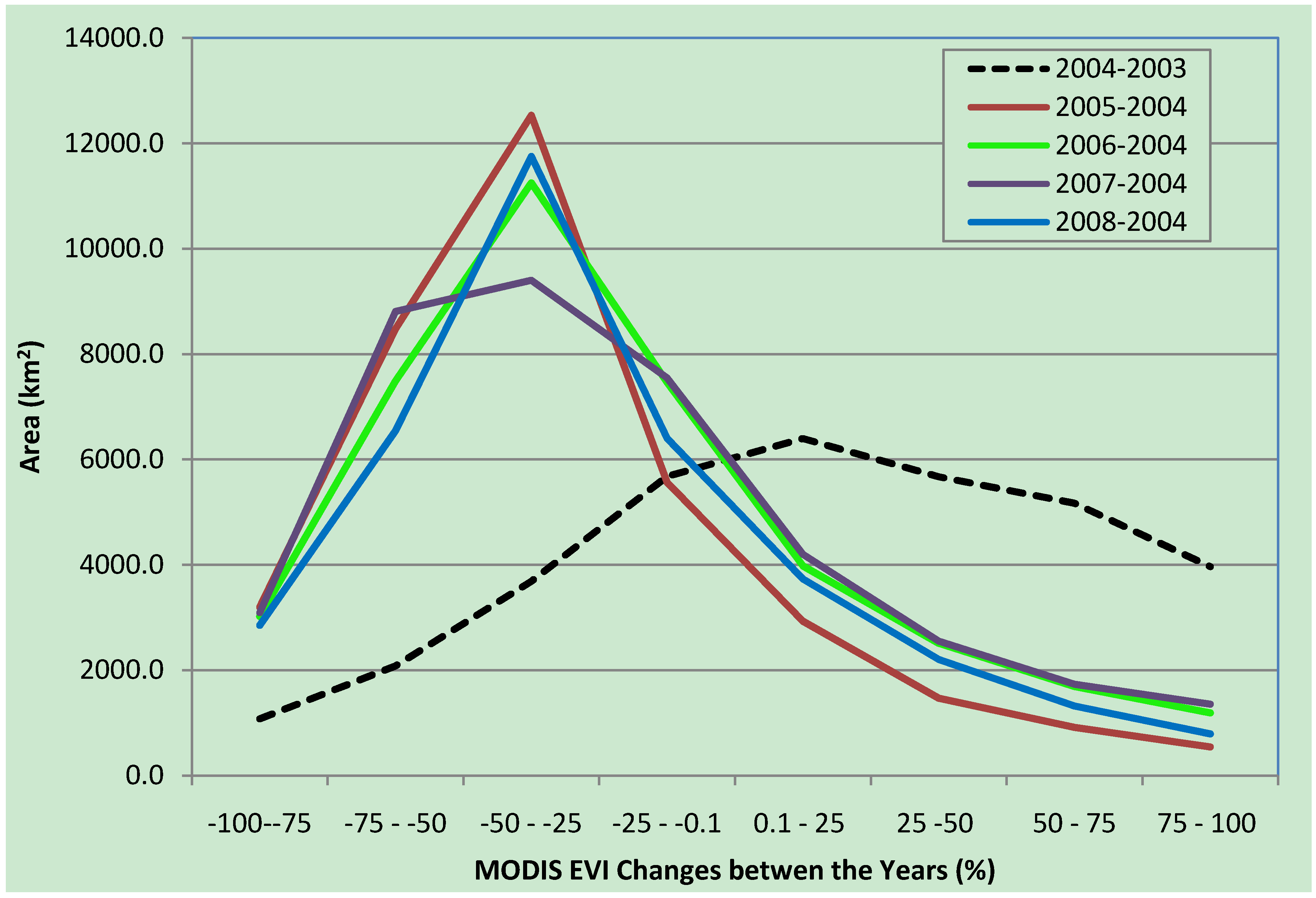
3.2. Disturbance Detection by EVI Changes between Years
3.2.1. Hurricanes Katrina and Rita


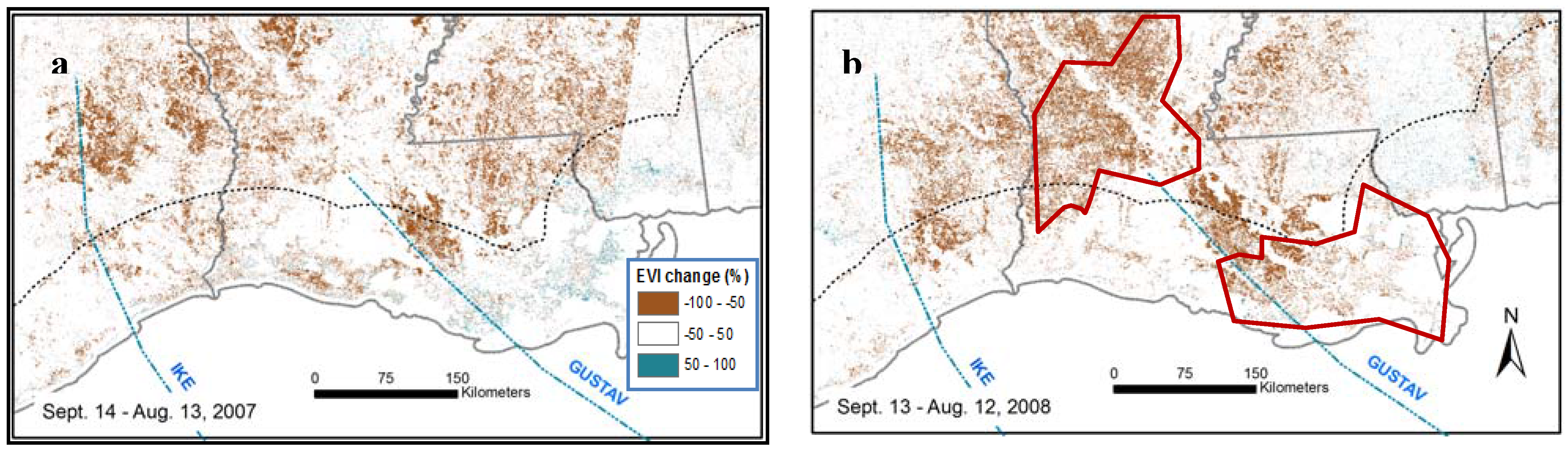
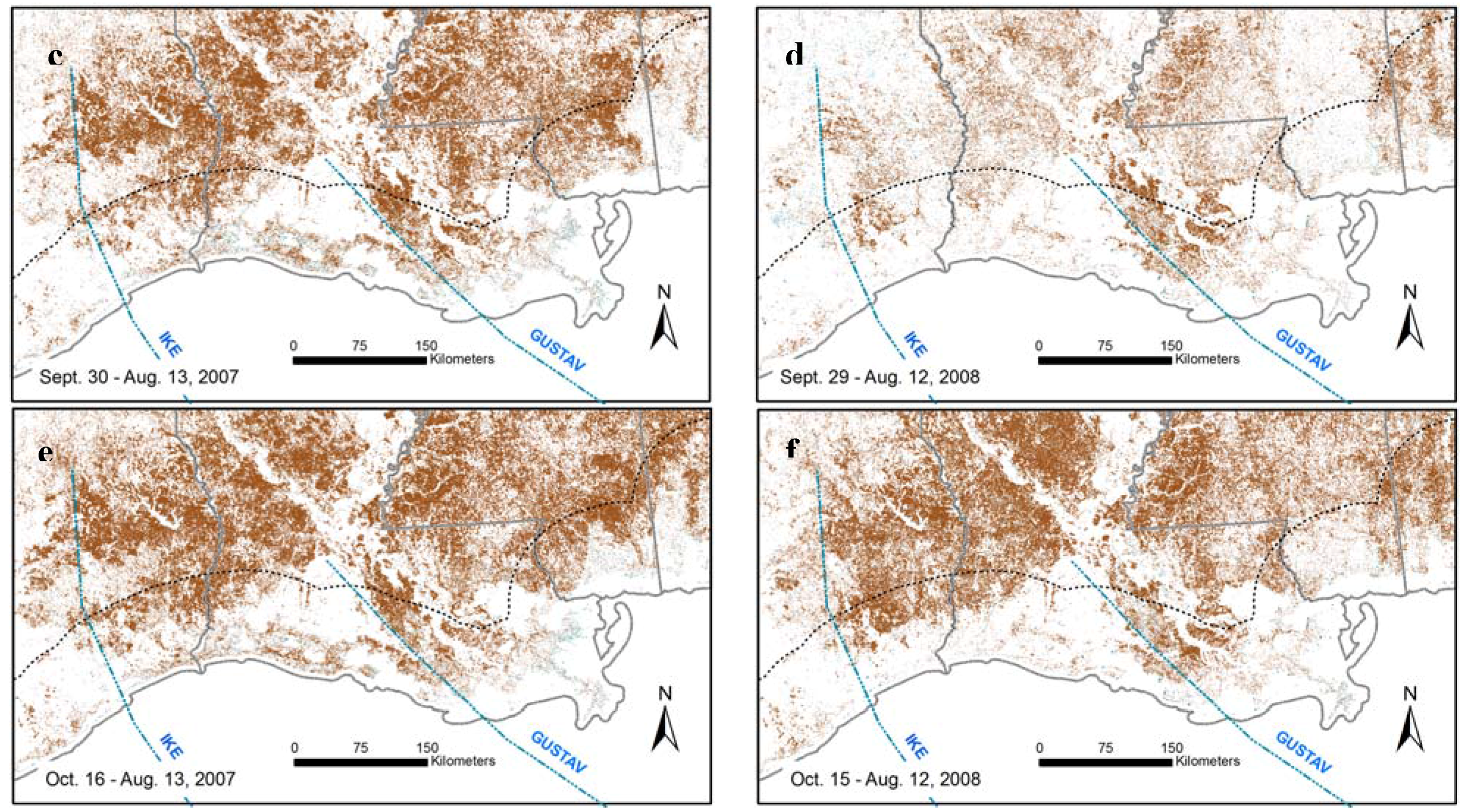
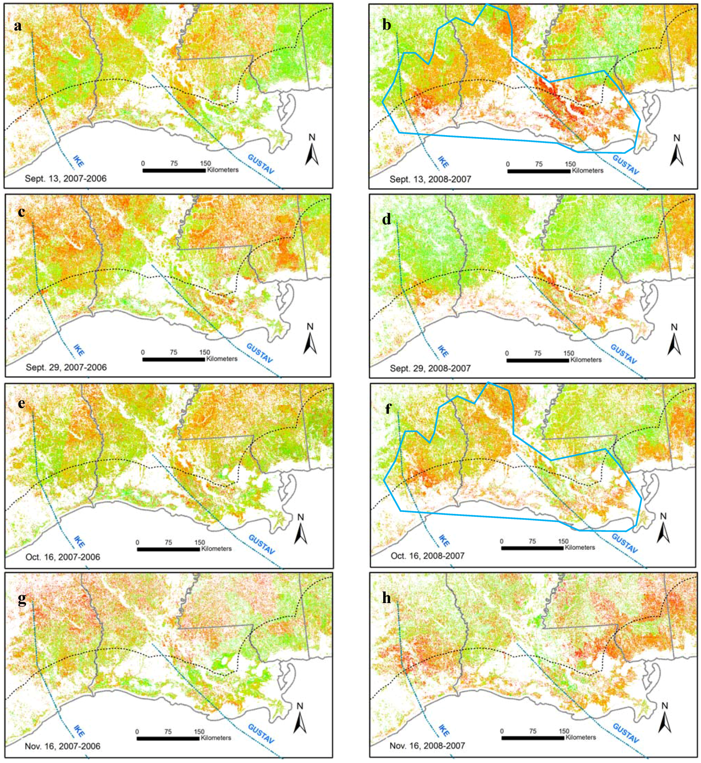
3.2.2. Hurricanes Gustav and Ike


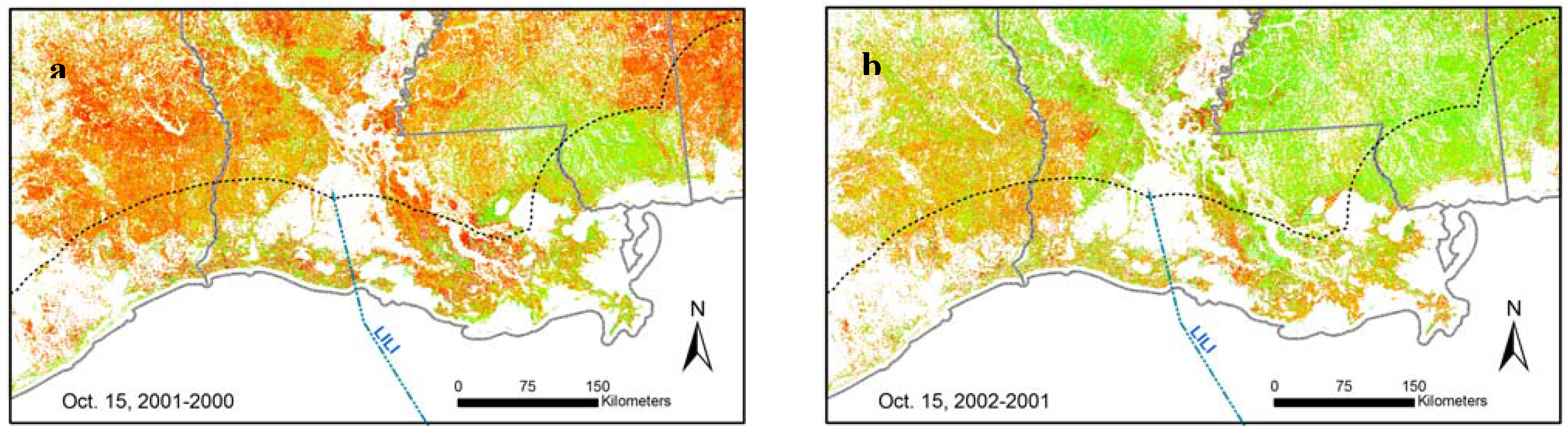
3.2.3. Lili


4. Discussion and Conclusions
Acknowledgements
References
- Bove, M.C.; Zierden, D.F.; O'Brien, J.J. Are Gulf landfalling hurricanes getting stronger? B. Am. Meteorol. Soc. 1998, 79, 1327–1328. [Google Scholar] [CrossRef]
- Change, S.J. The hurricane impact on southern pine sawtimber stumpage prices in Louisiana. Louisiana Agr. 2006, Spring Issue, 26–27. [Google Scholar]
- Middleton, B.A. Regeneration of coastal marsh vegetation impacted by Hurricanes Katrina and Rita. Wetlands 2009, 29, 54–65. [Google Scholar] [CrossRef]
- Wang, F.; Xu, Y.J. Hurricane Katrina-induced forest damage in relation to ecological factors at landscape scale. Environ. Monit. Assess. 2008. [Google Scholar] [CrossRef] [PubMed]
- Conner, W.H.; Day, J.W., Jr.; Baumann, R.H.; Randall, J.M. Influence of hurricanes on coastal ecosystems along the northern Gulf of Mexico. Wetlands Ecol. Manag. 1989, 1, 45–56. [Google Scholar] [CrossRef]
- Ramsey, E.; Rangoonwala, A.; Middleton, B.; Lu, Z. Satellite optical and radar data used to track wetland forest impact and short-term recovery from Hurricane Katrina. Wetlands 2009, 29, 66–79. [Google Scholar] [CrossRef]
- Mckee, K.L.; Cherry, J.A. Hurricane Katrina sediment slowed elevation loss in subsiding brackish marshes of the Mississippi River delta. Wetlands 2009, 29, 2–15. [Google Scholar] [CrossRef]
- Wang, H.; Hall, C.A.S. Modeling the effects of Hurricane Hugo on spatial and temporal variation in primary productivity and soil carbon and nitrogen in the Luquillo Experimental Forest, Puerto Rico. Plant Soil 2004, 263, 69–84. [Google Scholar] [CrossRef]
- Sherman, R.E.; Fahey, T.J.; Martinez, P. Hurricane impacts on a mangrove forest in the Dominican Republic: damage patterns and early recovery. Biotropica 2001, 33, 393–408. [Google Scholar] [CrossRef]
- Basnet, K. Recovery of a tropical rain-forest after hurricane damage. Plant Ecol. 1993, 109, 1–4. [Google Scholar] [CrossRef]
- Yih, K.; Boucher, D.H.; Vandemeer, J.H.; Zamora, N. Recovery of the rain-forest of Southeastern Nicaragua after destruction by Hurricane Joan. Biotropica 1991, 23, 106–113. [Google Scholar] [CrossRef]
- Yanez-Arancibia, A.; Day, J.W. Environmental sub-regions in the Gulf of Mexico coastal zone: the ecosystem approach as an integrated management tool. Ocean Coast. Manag. 2004, 47, 727–757. [Google Scholar] [CrossRef]
- Ucuncuoglu, E.; Arli, O.; Eronat, A.H. Evaluating the impact of coastal land uses on water-clarity conditions from Landsat TM/ETM+ imagery: Candarli Bay, Aegean Sea. Int. J. Remote Sens. 2006, 27, 3627–3643. [Google Scholar] [CrossRef]
- Wang, F.; Xu, Y.J. Comparison of remote sensing change detection techniques for assessing hurricane damage to forests. Environ. Monit. Assess. 2009. [Google Scholar] [CrossRef] [PubMed]
- Ramsey, E.W.; Chappell, D.K.; Baldwin, D.G. AVHRR imagery used to identify hurricane damage in a forested wetland of Louisiana. Photogramm. Eng. Remote Sens. 1997, 63, 293–297. [Google Scholar]
- Ramsey, E.W.; Hodgson, M.E.; Sapkota, S.K.; Nelson, G.A. Forest impact estimated with NOAA AVHRR and Landsat TM data related to an empirical hurricane wind-field distribution. Remote Sens. Environ. 2001, 77, 279–292. [Google Scholar] [CrossRef]
- Ayala-Silva, T.; Twumasi, Y.A. Hurricane Georges and vegetation change in Puerto Rico using AVHRR satellite data. Int. J. Remote Sens. 2004, 25, 1629–1640. [Google Scholar] [CrossRef]
- Nielsen, E.M. Rapid mapping of hurricane damage to forests. In Proceedings of the Eight Annual Forest Inventory and Analysis Symposium, Monterey, CA, USA; McRoberts, R.E., Reams, G.A., Van Deusen, P.C., McWilliams, W.H., Eds.; 2006; pp. 307–316. [Google Scholar]
- Huete, A.; Justice, C.; van Leeuwen, W. MODIS vegetation index (MOD 13)-algorithm theoretical basis document. Available online: http://modis.gsfc.nasa.gov/data/atbd/atbd_mod13.pdf (accessed on October 10, 2009).
- Abdollahi, K.; Collins, D.; Ning, Z.; Tarver, G. Urban forest ecosystem assessment for Gulfport, Mississippi prior to Hurricane Katrina's landfall. Phytopathology 2006, 96, S157–S157. [Google Scholar]
- Kupfer, J.A.; Myers, A.T.; McLane, S.E.; Melton, G.N. Patterns of forest damage in a southern Mississippi landscape caused by Hurricane Katrina. Ecosystems 2008, 11, 45–60. [Google Scholar] [CrossRef]
- Chapman, E.L.; Chambers, J.Q.; Ribbeck, K.F.; Baker, D.B.; Tobler, M.A.; Zeng, H.C.; White, D.A. Hurricane Katrina impacts on forest trees of Louisiana's Pearl River basin. Forest Ecol. Manag. 2008, 256, 883–889. [Google Scholar] [CrossRef]
- Wang, F.G.; Xu, Y.J. Hurricane Katrina-induced forest damage in relation to ecological factors at landscape scale. Environ. Monit. Assess. 2009, 156, 491–507. [Google Scholar] [CrossRef] [PubMed]
- Wang, F.G.; Xu, Y.J. Development and application of a remote sensing-based salinity prediction model for a large estuarine lake in the US Gulf of Mexico coast. J. Hydrol. 2008, 360, 184–194. [Google Scholar] [CrossRef]
- Cardno, C.A. Hurricane protection system reviewed, deemed successful during Hurricane Gustav. Civil Eng. 2009, 79, 30–32. [Google Scholar]
- Gutro, R. Landsat sees Louisiana wetland and barrier island loss from Hurricane Gustav. Available online: http://www.nasa.gov/mission_pages/hurricanes/archives/2009/wetlandloss_louisiana.html (accessed on October 25, 2009).
- Carloss, M.; Baker, T.; Lejeune, C.; Elsey, R.; Perry, G. Initial Hurricane Ike assessment for Coastal Operations and Nongame Resources Division. Available online: http://www.wlf.louisiana.gov/pdfs/hurricane/Initial_Hurricane_Ike_Assessment.pdf (accessed on October 20, 2009).
- Rodgers, J.C.; Murrah, A.W.; Cooke, W.H. The impact of Hurricane Katrina on the coastal vegetation of the Weeks Bay Reserve, Alabama from NDVI Data. Estuar. Coas. 2009, 32, 496–507. [Google Scholar] [CrossRef]
- Wang, W.; Qu, J. Assessment of post-hurricane forest damage using optical remote sensing. SPIE Newsroom-Remote Sens. 2009. DOI: 10.1117/2.1200906.1709. [Google Scholar]
- Farris, G. USGS scientists monitor coastal damage from Hurricane Lili. Available online at: http://www.eurekalert.org/pub_releases/2002-10/usgs-usm101102.php (accessed on October 8, 2009).
- Texas Forest Service Hurricane Ike timber damage report. Available online: http://txforestservice.tamu.edu/main/article.aspx?id=5588#contact (accessed on October 28, 2009).
© 2010 by the authors; licensee Molecular Diversity Preservation International, Basel, Switzerland. This article is an open-access article distributed under the terms and conditions of the Creative Commons Attribution license (http://creativecommons.org/licenses/by/3.0/).
Share and Cite
Wang, F.; D’Sa, E.J. Potential of MODIS EVI in Identifying Hurricane Disturbance to Coastal Vegetation in the Northern Gulf of Mexico. Remote Sens. 2010, 2, 1-18. https://doi.org/10.3390/rs2010001
Wang F, D’Sa EJ. Potential of MODIS EVI in Identifying Hurricane Disturbance to Coastal Vegetation in the Northern Gulf of Mexico. Remote Sensing. 2010; 2(1):1-18. https://doi.org/10.3390/rs2010001
Chicago/Turabian StyleWang, Fugui, and Eurico J. D’Sa. 2010. "Potential of MODIS EVI in Identifying Hurricane Disturbance to Coastal Vegetation in the Northern Gulf of Mexico" Remote Sensing 2, no. 1: 1-18. https://doi.org/10.3390/rs2010001